Showing 130 items matching "open cut mining"
-
 Federation University Historical Collection
Book, Sudtralasian Institute of Mining and Metallurgy, Latrobe Valley Brown Coal Resources: Geology, Exploration and Open Cut Mining Methods, 1960, 1960
... Latrobe Valley Brown Coal Resources: Geology, Exploration and Open Cut Mining Methods, 1960...Beer Latrobe Valley Brown Coal Resources: Geology, Exploration and Open Cut Mining Methods, 1960 Book Book Sudtralasian Institute of Mining and Metallurgy ...Red hard covered book. Block Prints on white pages, and sections of the Yallourn-Morwell field and the Yallourn Coal Field Includes the following chapters: * Contribution of the Minerals Industry to the Development of Australia by G.R. Fisher (including Gold, Broken Hill Field, Coal, Copper, Tin) * PLanning and Development of the Brown Coal Open Cuts of the State Electricity Commission of Victoria by E.D.J. Stewart * Geology of the Latrobe Valley Coalfield by C.S. Gloe * Developments in Equipment USed for Overburden Removal and Coal Winning in the Brown Coal Industry by H.C.G. Rodgers / J.M. Alexander * Development of Methods for Use of Punch Cards in the Recording of Drill Clogs in the Exploration for Brown Coal by H.E.C. Beernon-fictionyallourn, morwell, loy yang, brown coal, latrobe valley, aus imm, australian institute of mining and metallurgy, ausimm -
 Bendigo Historical Society Inc.
Newspaper - Kangaroo Flat Gold Mine Collection: Bendigo Mining
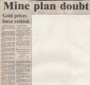
... ...open cut mining...Falling gold prices are forcing a rethink on Bendigo Mining's 'plans for open cut mining'. Bendigo Mining is planning open pits in Eaglehawk and Kangaroo Flat but may change their plan to develop underground mining projects. ...History House 11 Mackenzie Street Bendigo goldfields Gold mining Bendigo open cut mining Bendigo Mining Co. Doug Buerger Eaglehawk Kangaroo Flat 'Bendigo Advertiser' article, 8th July, 1997, 'Mine plan doubt'. ...'Bendigo Advertiser' article, 8th July, 1997, 'Mine plan doubt'. Falling gold prices are forcing a rethink on Bendigo Mining's 'plans for open cut mining'. Bendigo Mining is planning open pits in Eaglehawk and Kangaroo Flat but may change their plan to develop underground mining projects. gold mining, bendigo, open cut mining, bendigo mining co., doug buerger, eaglehawk, kangaroo flat -
 Bendigo Historical Society Inc.
Newspaper - Kangaroo Flat Gold Mine Collection: letters to Bendigo Advertiser Editor
... ...open cut mining...'A Balance to Open Cut Mining', 16th July 2001, by '. Letter refers to Geoff Turner's letter and writes to bring 'balance to this subject' 4. ...'A Balance to Open Cut Mining', 16th July 2001, by '. Letter refers to Geoff Turner's letter and writes to bring 'balance to this subject' 4. ...Three photocopies and one original 'Bendigo Advertiser' articles, 'Letters to the Editor': 1. 'Mine statements are naive', June 6, 2001, from Tony Lethlean, Don Street, Bendigo. Letter discusses the damage done to the environment by farming and logging compared to mining. 2. "Mining letter is misleading' 4th July, 2001, from Geoff Turner, AIG Victorian Branch, Strathfieldsaye. Letter discusses 'misleading information circulating in the wider Strathfieldsaye area' regarding the mining operations proposed by Perseverance Exploration Pty. Ltd. 3. 'A Balance to Open Cut Mining', 16th July 2001, by '. Letter refers to Geoff Turner's letter and writes to bring 'balance to this subject' 4. Bendigo Advertiser original copy of article: 'Cornish statue feature pleasing' 22nd January, 2001, by Ruth Hopkins, Peel Street, Bendigo. Ruth's letter discusses the history of the Cornish miner in Bendigo; the largest ethnic group on the field. The statue of the Cornish miner came about as a project of the Bendigo Cornish Association. gold mining, bendigo, perserverance exploration pty ltd., open cut mining, bendigo advertiser, tony lethlean, geoff turner, ruth hopkins, cornish association, fosterville gold mine, luch and graeme reed, objectors, cornish statue -
 The Beechworth Burke Museum
Photograph, unknown
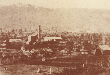
... ...open cut mining...Rocky Mountain Extended Gold Sluicing Company gold sluicing gold sluicing hydraulic sluicing gold mine open cut mining mining gold mining north-east victoria beechworth burke museum Obverse: Reverse: 84.222.5/ digital print/ Black and white rectangular reproduced photograph printed on glossy photographic paper Photograph Photograph ...This reproduced photograph is of Pennyweight Flat near Beechworth, a notable area of the 1850's gold rush in Victoria. Donald Fletcher, migrating to Beechworth from Scotland in 1855, had substantial claims at Pennyweight Flat and was amongst the first in the district to utilise hydraulic sluicing and water diverting methods.The flat is said to have seen a flurry of 200 miners to the area around 1857, and by 1861 when work commenced on extending Fletcher's tail race the census recorded 644 people residing there (European males, females and Chinese).The search for gold is ingrained into the history of Victoria and therefore, images like this one which portray an open cut sluicing site can reveal important information for society and technology for the date when the photograph was taken. This image is of important historical significance for its ability to convey information about sluicing and the methods used to find gold in 1910. It also shows a location where sluicing was undertaken which provides insight into the impact of sluicing on the environment at a time when it was done. This image is important for current research into the history of Beechworth and surrounding area including Victoria's North East. The Rocky Mountain Extended Gold Sluicing Company was a long running and very active mine that was one of the most successful and largest in the district. Therefore, this image has the capacity to be beneficial for research into society and the motivations of those living and working in this region during this period and therefore, has social significance. The Beechworth Burke Museum has additional images relating to gold sluicing which can be analysed and studied alongside images like this one. When the mine closed in 1921, in a liquidation sale, Zwar purchased the tunnel and clear water supply that ran under the town of Beechworth. He directed the water to his tannery and over time built a major industry in leather works that was a major employer in Beechworth. In growing his leather business, Zwar installed crude oil engines for electricity in his factory. He oversaw working with local council to introduce electricity to Beechworth via a sub-station on Albert Street. In 1927 Electric street lamps replaced gas lamps in the streets of Beechworth. Black and white rectangular reproduced photograph printed on glossy photographic paperObverse: Reverse: 84.222.5/ digital print/ rocky mountain extended gold sluicing company, gold, sluicing, gold sluicing, hydraulic sluicing, gold mine, open cut mining, mining, gold mining, north-east victoria, beechworth, burke museum -
 The Beechworth Burke Museum
Photograph, 1910
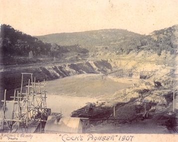
... ...open cut mining...Cock founded his gold and tin mining company which ran successfully for many years in the El Dorado region. It was an open cut sluicing company because of the abandonment of underground mining after this was deemed too dangerous. ...The Beechworth Burke Museum has additional images relating to gold sluicing and El Dorado which can be analysed and studied alongside images like this one. el dorado north east gold sluicing gold sluicing hydraulic sluicing 1910 gold and tin mine open cut mining mining gold mining north-east victoria beechworth burke museum Obverse: COCKS PIONEER Q + T SL CO, N.L. / 1910 / LOOKING EAST UP OPEN CUT / FROM NO3 BARGE SITE / Reverse: 1997 . 2611 / A02611 Sepia coloured rectangular photograph printed on gloss photographic paper mounted on board. ...This photograph dating to 1910 depicts an open cut sluicing site located in El Dorado captured looking east up the open cut from the number 3 Barge site. Sluicing was undertaken in the area from 1900 to 1942 with some short breaks between these periods. The image depicts a location mined by Cocks Pioneer Gold and Tin Sluicing Company (as recorded on the annotation on the card mount). It portrays open cut rocks with a crevice in the center of the image where the sluicing was being undertaken. There is a small timber structure on the right of the image which could be an entrance to a mine or supports made of wood to prevent a cave in at the open cut site and above the cut rock there is bush. The timber structure has rail tracks on top of the bridge which could suggest the identification of this structure as a mine entrance. The rail tracks were used for little carts which hauled soil from the mine. The Cocks Pioneer Gold and Tin Mines N.L was one of El Dorado's two largest open cut sluicing mines of the 20th Century. The other was named the Cocks El Dorado Gold Dredging Company. The Cocks Pioneer Mines operated from 1901 until 1941 and found a total of 117,378 ounces of Gold and 1,673 tones of tin concentrates over these years. The Cocks company was formed in 1898 and operated until 1941. Open cut sluicing involved the use of high-powered hoses which used the centrifugal sand pump system (known as hydraulic sluicing) which broke down the soil which was then processed for gold and other precious metals. From 1914 , four years after this image was captured, the company reformed to Cocks Pioneer Gold and Tin Mines NL (previously it was known as Cocks Pioneer Sluicing Co) and undertook large scale sluicing operations until 1929 and then 1934-1941. El Dorado is located on Reedy Creek and is surrounded by forested country to the north and east. It is 20 km east of Wangaratta in Victoria's regional north-east. John Cock was the son of a Cornish minor who arrived in El Dorado in 1858. Cock founded his gold and tin mining company which ran successfully for many years in the El Dorado region. It was an open cut sluicing company because of the abandonment of underground mining after this was deemed too dangerous. In 1935 Cock's El Dorado Company commissioned the floating dredge which is still visible in El Dorado today. The dredge was built by the Thompson engineering works, Castlemaine, and weighed over 2,000 tones and today has a place on the Victorian Registers of historic buildings. Interestingly, the name El Dorado does not derive from the gold in the region, but from the Barambogie pastoral run completed by William Baker in 1840-1841. Gold was discovered in El Dorado 1854 but the gold was too deep for individual prospectors to find, it required the use of heavy machinery.The search for gold is ingrained into the history of Victoria and therefore, images like this one which portray an open cut sluicing site can reveal important information for society and technology for the date when the photograph was taken. This image is of important historical significance for its ability to convey information about sluicing and the methods used to find gold in 1910. It also shows a location where sluicing was undertook which provides insight into the impact of sluicing on the environment at a time when it was done. This image is important for current research into the history of El Dorado, a small regional location near Wangaratta in Victoria's North East. Therefore, this image has the capacity to be beneficial for research into society and the motivations of those living and working in this region during this period and therefore, has social significance. The Beechworth Burke Museum has additional images relating to gold sluicing and El Dorado which can be analysed and studied alongside images like this one.Sepia coloured rectangular photograph printed on gloss photographic paper mounted on board.Obverse: COCKS PIONEER Q + T SL CO, N.L. / 1910 / LOOKING EAST UP OPEN CUT / FROM NO3 BARGE SITE / Reverse: 1997 . 2611 / A02611el dorado, north east gold, sluicing, gold sluicing, hydraulic sluicing, 1910, gold and tin mine, open cut mining, mining, gold mining, north-east victoria, beechworth, burke museum -
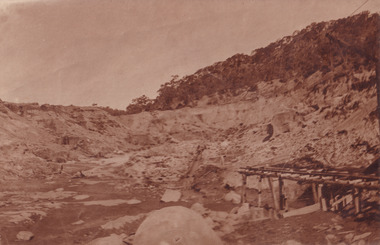
 Ballarat Tramway Museum
Document, 'State Electricty Commission of Victoria Rail Transport: Yallourn Open Cut"
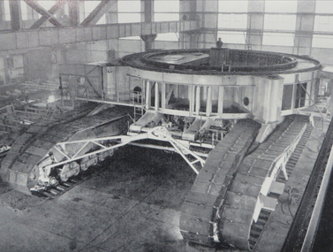
... ...Open cut mining...open cuts and the transport of coal and the locomotives used in the Latrobe Valley operations of the SEC. Possibly prepared in the early 1980s. Rail operations on the interconnecting railway ceased in 2000. Shows outline diagrams of the steam, electric and diesel locomotives and the coal wagons. Provides information about the SEC Coal railways and their rolling stock used for power generation in Victoria. SEC Tramways power supply SECV Open cut mining ...Provides details of the history of SECV rail operations in the Yallourn and other power station open cuts and the transport of coal and the locomotives used in the Latrobe Valley operations of the SEC. Possibly prepared in the early 1980s. Rail operations on the interconnecting railway ceased in 2000. Shows outline diagrams of the steam, electric and diesel locomotives and the coal wagons.Provides information about the SEC Coal railways and their rolling stock used for power generation in Victoria.Report or document - 16 A4 pages titled Report - 'State Electricty Commission of Victoria Rail Transport: Yallourn Open Cut"sec tramways, power supply, secv, open cut mining, locomotives, interconnecting railway -
 El Dorado Museum Association Inc.
Photograph (item) - Digital Image
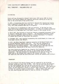
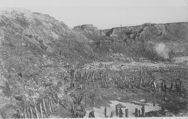
... mining...gold...tin...open cut...Cock’s Pioneer Gold and Tin Mines NL carried on large-scale hydraulic sluicing operations until 1941. mining gold tin open cut gold mining tin mining cocks pioneer el dorado eldorado Digital image copied from a black and white photograph of open cut mine with left over timbers in ground. ...Cocks Pioneer old mine timbers. Cocks Pioneer Electric Gold & Tin Mine Company was formed in 1899. The company's first power station, located at the eastern end of the valley began operating with its 340 Kilowatt steam-powered generator. By 1909, from 2,500,000 cubic yards worked, reported recovery was 17,284 ounces of gold and 224 tons of tin ore. By 1909, Cocks Pioneer’s power plant had become inadequate and uneconomical. The barge was floated downstream about a mile, but lost time caused the operations to cease. Following testing, a new mine was established by diverting Reid's Creek at a cost of £25 000. Settling dams were built, one of which held 1,935,900 cubic feet. Sold earth banks, built against a wall of stringy bark saplings constructed and laced with vertical props, were built. In 1914, the company was reformed as Cock’s Pioneer Gold and Tin Mines NL, another power station was constructed at the western end of the township, near the junction of Clear and Reid's Creeks. From 6,800,000 cubic yards of material processed, the returns were 64,397 ounces of gold and 855 ton of tin. Cocks Pioneer mine then moved the barge downs stream and continued sluicing. In 1929 Cocks Pioneer Electric Gold and Tin Mining Company ceased operations due to a drop in values. Cock’s Pioneer Gold and Tin Mines NL carried on large-scale hydraulic sluicing operations until 1941. mining, gold, tin, open cut, gold mining, tin mining, cocks pioneer, el dorado, eldorado -
 El Dorado Museum Association Inc.
Photograph (item) - Digital Image
... mining...gold...tin...open cut...Cock’s Pioneer Gold and Tin Mines NL carried on large-scale hydraulic sluicing operations until 1941. mining gold tin open cut sluicing gold mining tin mining cocks pioneer el dorado eldorado Digital image copied from a black and white photograph of open cut area of mine, showing pipes running through middle of image and large sections of pipes in foreground. ...Cocks Pioneer Pipes and Open Cut. Cocks Pioneer Electric Gold & Tin Mine Company was formed in 1899. The company's first power station, located at the eastern end of the valley began operating with its 340 Kilowatt steam-powered generator. By 1909, from 2,500,000 cubic yards worked, reported recovery was 17,284 ounces of gold and 224 tons of tin ore. By 1909, Cocks Pioneer’s power plant had become inadequate and uneconomical. The barge was floated downstream about a mile, but lost time caused the operations to cease. Following testing, a new mine was established by diverting Reid's Creek at a cost of £25,000. Settling dams were built, one of which held 1,935,900 cubic feet. Sold earth banks, built against a wall of stringy bark saplings constructed and laced with vertical props, were built. In 1914, the company was reformed as Cock’s Pioneer Gold and Tin Mines NL, another power station was constructed at the western end of the township, near the junction of Clear and Reid's Creeks. From 6,800,000 cubic yards of material processed, the returns were 64 397 ounces of gold and 855 ton of tin. Cocks Pioneer mine then moved the barge downs stream and continued sluicing. In 1929 Cocks Pioneer Electric Gold and Tin Mining Company ceased operations due to a drop in values. Cock’s Pioneer Gold and Tin Mines NL carried on large-scale hydraulic sluicing operations until 1941. mining, gold, tin, open cut, sluicing, gold mining, tin mining, cocks pioneer, el dorado, eldorado -
 El Dorado Museum Association Inc.
Photograph (item) - Digital Image
... mining...gold...tin...open cut...Cock’s Pioneer Gold and Tin Mines NL carried on large-scale hydraulic sluicing operations until 1941. mining gold tin open cut barge gold mining tin mining cocks pioneer el dorado eldorado Handwritten across front: 'HAROLD S. ...Cocks Pioneer, 1907. Cocks Pioneer Electric Gold & Tin Mine Company was formed in 1899. The company's first power station, located at the eastern end of the valley began operating with its 340 Kilowatt steam-powered generator. By 1909, from 2,500,000 cubic yards worked, reported recovery was 17,284 ounces of gold and 224 tons of tin ore. By 1909, Cocks Pioneer’s power plant had become inadequate and uneconomical. The barge was floated downstream about a mile, but lost time caused the operations to cease. Following testing, a new mine was established by diverting Reid's Creek at a cost of £25,000. Settling dams were built, one of which held 1,935,900 cubic feet. Sold earth banks, built against a wall of stringy bark saplings constructed and laced with vertical props, were built. In 1914, the company was reformed as Cock’s Pioneer Gold and Tin Mines NL, another power station was constructed at the western end of the township, near the junction of Clear and Reid's Creeks. From 6,800,000 cubic yards of material processed, the returns were 64,397 ounces of gold and 855 ton of tin. Cocks Pioneer mine then moved the barge downs stream and continued sluicing. In 1929 Cocks Pioneer Electric Gold and Tin Mining Company ceased operations due to a drop in values. Cock’s Pioneer Gold and Tin Mines NL carried on large-scale hydraulic sluicing operations until 1941. Handwritten across front: 'HAROLD S. TEMBY / Photo'; '"COCKS PIONEER" 1907'.mining, gold, tin, open cut, barge, gold mining, tin mining, cocks pioneer, el dorado, eldorado -
 Bendigo Historical Society Inc.
Photograph - Sand mining at the Whipstick
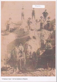
... Old Tom mine included quartz mining and open cut mining. Today the remains of the battery site, cyanide plant, hydrolic sluicing and a 1930's puddler can be seen. ...History House 11 Mackenzie Street Bendigo goldfields Old Tom mine included quartz mining and open cut mining. Today the remains of the battery site, cyanide plant, hydrolic sluicing and a 1930's puddler can be seen. ...Old Tom mine included quartz mining and open cut mining. Today the remains of the battery site, cyanide plant, hydrolic sluicing and a 1930's puddler can be seen. It was operating in August 1874 and was taken over in 1897 by an English syndicate, J. R. Syndicate. By 1899 the mine had reached 500 feet in depth . The mine closed c. 1901. Sand mining at Old Tom mine the Whipstick, Eaglehawk. O'Halloran's team of nine men and two horses and carts. Two men with horse and carts; and seven men on top of the sand deposit. A4 copy of 1513 Box 25sand mining, whipstick, old tom mine -
 Ballarat Heritage Services
Photograph - Image - Black and White, Old Works, Black Hill Gully, Ballarat, c1904, c1904
... mining...open cut...The mill ran 24 hours a day until the end of 1864 and 12 hours a day in 1865. Open cut mining then ceased. Underground ore extraction continued at Black Hill until the early twentieth century....The mill ran 24 hours a day until the end of 1864 and 12 hours a day in 1865. Open cut mining then ceased. Underground ore extraction continued at Black Hill until the early twentieth century. ballarat black hill mining open cut gold Photographic image of the abandoned open-cut mine at Black Hill, Ballarat, c1904 Old Works, Black Hill Gully, Ballarat, c1904 Photograph Image - Black and White ...The first company to make a success of hard-rock (quartz) gold mining at Black Hill was the Black Hill Company, formed in 1859. Mining from the open-cut mine probably commenced in 1860 and by 1861 the company had erected the largest stamping mill in Victoria. The mill ran 24 hours a day until the end of 1864 and 12 hours a day in 1865. Open cut mining then ceased. Underground ore extraction continued at Black Hill until the early twentieth century.Photographic image of the abandoned open-cut mine at Black Hill, Ballarat, c1904 ballarat, black hill, mining, open cut, gold -
 Bendigo Historical Society Inc.
Photograph - FORTUNA COLLECTION: FORTUNA VILLA
... The Ballestedt's pioneered open cut and quartz mining on the Bendigo gold field. ...The Ballestedt's pioneered open cut and quartz mining on the Bendigo gold field. ...Originally built by Christopher Ballestedt (1796-1869) and his son Theodore. The Ballestedt's pioneered open cut and quartz mining on the Bendigo gold field. They were very successful. After Christopher's death, Theodore continued until 1871 when he sold Fortuna, their mines and equipment to George Lansell for 30,000 pounds.Two Large black and white photographs of Fortuna Villa in the early days. Also 2 portrait photos of Edith and George Lansell. bendigo, house, fortuna villa -
 Bendigo Historical Society Inc.
Plan - FORTUNA COLLECTION: FORTUNA VILLA
... The Ballestedt's pioneered open cut and quartz mining on the Bendigo gold field. ...The Ballestedt's pioneered open cut and quartz mining on the Bendigo gold field. ...Originally built by Christopher Ballestedt (1796-1869) and his son Theodore. The Ballestedt's pioneered open cut and quartz mining on the Bendigo gold field. They were very successful. After Christopher's death, Theodore continued until 1871 when he sold Fortuna, their mines and equipment to George Lansell for 30,000 pounds.Four large plans of Fortuna villa. Scale 1:50 Australian survey office - Victoria Department of Administrative services. Fortuna Bendigo - Army Survey Regiment. Dept. of Defence - Army. Terrestrial Photogrammetric Survey. Project number: 8001/2. Reg. File: 64/531. Survey File:631. Draftsman: M.A. Osciak. Surveyed by G. Tucker. Date of Survey: 14/05/79. There are 4 large such plans in a plastic bag the measurement of the plans is approx. 115cm X 80 cm.plan, bendigo, fortuna villa -
 Federation University Historical Collection
Booklet, A History of the Yallourn Power Station and Briquette Factory
... Mining Company...electricty demand...john monash...State electricity commission...Yallourn north open cut...Barker Library (top floor) Mount Helen goldfields Latrobe Valley Brown coal Yallourn power generation morwell power station Gunai kurnai Aborigines gippsland bark canoe angus mcmillan george augustus robinson william thomas Lake tyers Ramahyuck hazelwood morwell Great Morwell Coal Mining Company electricty demand john monash State electricity commission Yallourn north open cut A.R/ La gerche Yallourn POwer station yallourne briquette Factory Bill morrison f. hasse Ernest bates migration Morwell gas plant A history ofof the Yallourn Power Station and Briquette Factory A History of the Yallourn Power Station and Briquette Factory Booklet ...A history ofof the Yallourn Power Station and Briquette Factorylatrobe valley, brown coal, yallourn, power generation, morwell power station, gunai kurnai, aborigines, gippsland, bark canoe, angus mcmillan, george augustus robinson, william thomas, lake tyers, ramahyuck, hazelwood, morwell, great morwell coal mining company, electricty demand, john monash, state electricity commission, yallourn north open cut, a.r/ la gerche, yallourn power station, yallourne briquette factory, bill morrison, f. hasse, ernest bates, migration, morwell gas plant -
Federation University Historical Collection
Book - Book - Scrapbook, Ballarat School of MInes: Scrapbook of Newspaper Cuttings, Book 35, April 1988 to July 1988
... The papers concerned are The Courier, Ballarat, The Australian, The Age over the period of 22 July 1988 to 3 October 1987. teaching positions advertised pre-employment courses courses available enrolment for smb courses aboriginal flag for smb $600000 for science studies building arbor day at victoria park smb and local industry smb's marketing company inskill ltd open learning for maths students pilot business program industry oriented training scheme rob webber new enterprise incentives scheme gerardine christou myra morgan art and craft teacher 1950s new computer software for engineers more adults return to school cuts to special school funding transition program hospitality studies - certificate of catering anne-marie allison christine brady robert reilly sue collins sculptor peter blizzard student andrew burnham ricky hains wins tippett award kandra chapman award winner sheetmetal women's access group smb women's trade and technical program offended girl mechanic hit back mining course at smb kerrie cross council president adult literacy tutors june huggins josie micich hospitality traineeship system launched farm manager computer program course peter quinn peter davis federal grant to john valves special course on stoneware glazes ceramics instructor neville french players find home at smb michael staley winning apprentice ballarat small business centre quality control course at smb calligraphyteacher eddie goodson Book with green cover, front, spiral bound. ...Collection of newspaper articles related to Ballarat School Of Mines.They cover activities and advertisements for staff. The papers concerned are The Courier, Ballarat, The Australian, The Age over the period of 22 July 1988 to 3 October 1987.Book with green cover, front, spiral bound. teaching positions advertised, pre-employment courses, courses available, enrolment for smb courses, aboriginal flag for smb, $600000 for science studies building, arbor day at victoria park, smb and local industry, smb's marketing company inskill ltd, open learning for maths students, pilot business program, industry oriented training scheme, rob webber, new enterprise incentives scheme, gerardine christou, myra morgan art and craft teacher 1950s, new computer software for engineers, more adults return to school, cuts to special school funding, transition program, hospitality studies - certificate of catering, anne-marie allison, christine brady, robert reilly, sue collins, sculptor peter blizzard, student andrew burnham, ricky hains wins tippett award, kandra chapman award winner sheetmetal, women's access group, smb women's trade and technical program, offended girl mechanic hit back, mining course at smb, kerrie cross council president, adult literacy tutors, june huggins, josie micich, hospitality traineeship system launched, farm manager computer program course, peter quinn, peter davis, federal grant to john valves, special course on stoneware glazes, ceramics instructor neville french, players find home at smb, michael staley winning apprentice, ballarat small business centre, quality control course at smb, calligraphyteacher eddie goodson -
Federation University Historical Collection
Book - Book - Scrapbook, Ballarat College of Advanced Education: Scrapbook of newspaper cutting, Book 9; March 1981 to September 1981
... Many items are dedicated to the opening of Founder's Hall. . employment advertisements application for enrolment outline of courses wind power at bcae cash outlook gloomy concert to celebrate hall opening grim look for teachers opening of founder's hall conferring of degrees at founder's hall bhp chief at degree conferring way to economic growth education mission from china library award to bcae student helen hately 50 years on college enrolments climb ronald potter winner of a e stohr medal of the institution of engineers stop college cuts political bias denied protest at education cuts graduate tom honeyman at bcae college water supply bcae field trip to western australia lectures for industry bill rofe zig plavina careers in sciences seminar fitness for volunteers study of walnuts a hit siddons plan solar heating thrust william charters inventor jobs that go begging shortage of engineers careers seminar at bcae morgan john retires prints by students on show pam dethridge hard work pays off labor pledge on education unemployment in ballarat bcae student dinner advanced learning program for secondary students first exhibition for eric collins 30 escape bus crash mining cadetship awarded to tom devries bcae open day technology week getting the facts at bcae memorial lecture prof weston bate tertiary education disadvantaged goldrush miners relied on luck more tafe funding 'not enough' equus ready for stage mineral exports vital Book with grey cover, front. ...Newspaper cuttings relating to Ballarat College of Advanced Education. These are from various newspapers and include The Age, Ballarat Courier, The Australian, The Herald. The cuttings cover the period from 12 March 1981 to 1 September 1981. Many items are dedicated to the opening of Founder's Hall. . Book with grey cover, front. Image of draught horses. Spiral bound.employment advertisements, application for enrolment, outline of courses, wind power at bcae, cash outlook gloomy, concert to celebrate hall opening, grim look for teachers, opening of founder's hall, conferring of degrees at founder's hall, bhp chief at degree conferring, way to economic growth, education mission from china, library award to bcae student, helen hately, 50 years on, college enrolments climb, ronald potter winner of a e stohr medal of the institution of engineers, stop college cuts, political bias denied, protest at education cuts, graduate tom honeyman at bcae, college water supply, bcae field trip to western australia, lectures for industry, bill rofe, zig plavina, careers in sciences seminar, fitness for volunteers, study of walnuts a hit, siddons plan solar heating thrust, william charters inventor, jobs that go begging, shortage of engineers, careers seminar at bcae, morgan john retires, prints by students on show, pam dethridge, hard work pays off, labor pledge on education, unemployment in ballarat, bcae student dinner, advanced learning program for secondary students, first exhibition for eric collins, 30 escape bus crash, mining cadetship awarded to tom devries, bcae open day, technology week, getting the facts at bcae, memorial lecture, prof weston bate, tertiary education disadvantaged, goldrush miners relied on luck, more tafe funding 'not enough', equus ready for stage, mineral exports vital -
Federation University Historical Collection
Book - Book - Scrapbook, Ballarat College of Advanced Education: Scrapbook of newspaper cutting, Book 18; June 1986 to October 1986
... cut traffic chaos...uncle vanya production...importance of physical well-being...jack barker to quit...steve moneghetti...dorothy crocker and music...conservation balance sheet needed...bcae open on sunday...open day...chemistry with a difference...durant memorial lecture...sharon stewart wins bronze...awards for students...scott ramsay...students draw plan for park...teachers visit goldfields...mining...The cuttings cover the period from 28 June 1986 to 27 October 1986. . employment advertisements application for enrolment outline of courses ballarat college of advanced education bcae bcae health education course ymca pool users "short-cut degrees" bcae commercial day christmas in july "vanya' is a modern tale bcae birthday celebrations six faculties children's diets under scrutiny gravity separator for minerals leigh oliver wins art prize ballarat needs training venue swimming widdop to visit u s and u k aquinas to offer nurse training funding system bid to cut traffic chaos uncle vanya production importance of physical well-being jack barker to quit steve moneghetti dorothy crocker and music conservation balance sheet needed bcae open on sunday open day chemistry with a difference durant memorial lecture sharon stewart wins bronze awards for students scott ramsay students draw plan for park teachers visit goldfields mining seminar course to coach coaches bound for the big desert student found boost for country sport art of murals career expo garry's memorable month fees protest Book with yellow cover, front. ...Newspaper cuttings relating to Ballarat College of Advanced Education. These are from various newspapers and include The Age, Ballarat Courier, The Australian, The Herald. The cuttings cover the period from 28 June 1986 to 27 October 1986. . Book with yellow cover, front. Spiral bound.employment advertisements, application for enrolment, outline of courses, ballarat college of advanced education, bcae, bcae health education course, ymca pool users, "short-cut degrees", bcae commercial day, christmas in july, "vanya' is a modern tale, bcae birthday celebrations, six faculties, children's diets under scrutiny, gravity separator for minerals, leigh oliver wins art prize, ballarat needs training venue, swimming, widdop to visit u s and u k, aquinas to offer nurse training, funding system, bid to cut traffic chaos, uncle vanya production, importance of physical well-being, jack barker to quit, steve moneghetti, dorothy crocker and music, conservation balance sheet needed, bcae open on sunday, open day, chemistry with a difference, durant memorial lecture, sharon stewart wins bronze, awards for students, scott ramsay, students draw plan for park, teachers visit goldfields, mining seminar, course to coach coaches, bound for the big desert, student found, boost for country sport, art of murals, career expo, garry's memorable month, fees protest -
 Bendigo Historical Society Inc.
Photograph - MINE
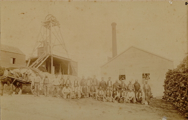
... Mining site mine? Sepia photo on fawn board. 27 workmen in front of mine buildings, horse and dray on left, poppet head to left, mine building and chimney stack. Large pile of cut wood on right. 3 men sitting in open ...Sepia photo on fawn board. 27 workmen in front of mine buildings, horse and dray on left, poppet head to left, mine building and chimney stack. Large pile of cut wood on right. 3 men sitting in open windows of building behind group. Blue pencil line drawn on the board, framing the photo.place, mining site, mine? -
 Bendigo Historical Society Inc.
Document - LONG GULLY HISTORY GROUP COLLECTION: HISTORY OF THE FIELD (GOLD)
... The history starts in 1851 when gold was discovered along the Bendigo Creek to 1992 when Bendigo Mining NL purchased the licences and infrastructure from WMC. There are four small photos: Two men working a puddling machine; Victoria Hill - 1850's Open Cut; Victoria Hill Quartz Mine, and the Central Deborah Mine. ...The history starts in 1851 when gold was discovered along the Bendigo Creek to 1992 when Bendigo Mining NL purchased the licences and infrastructure from WMC. There are four small photos: Two men working a puddling machine; Victoria Hill - 1850's Open Cut; Victoria Hill Quartz Mine, and the Central Deborah Mine. ...Three pages of History of the Field, A Brief History of Mining in Bendigo. The history starts in 1851 when gold was discovered along the Bendigo Creek to 1992 when Bendigo Mining NL purchased the licences and infrastructure from WMC. There are four small photos: Two men working a puddling machine; Victoria Hill - 1850's Open Cut; Victoria Hill Quartz Mine, and the Central Deborah Mine. There is also a web address in the top right corner.bendigo, history, long gully history group, the long gully history group - history of the field (gold), mrs margaret kennedy, mrs farrell, edward nucella emmett, cave and amos, victoria quartz, new chum railway, bendigo amalgamated gold mies, bendigo mines ltd, deborah mines, william burrell, wmc, williams united, charshalton, bendigo mining nl, new bendigo project, trevor clark, shelley saunders, peter wiseman, new bendigo - 10 million ounces of gold -
 Bendigo Historical Society Inc.
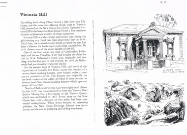
Document - LONG GULLY HISTORY GROUP COLLECTION: VICTORIA HILL
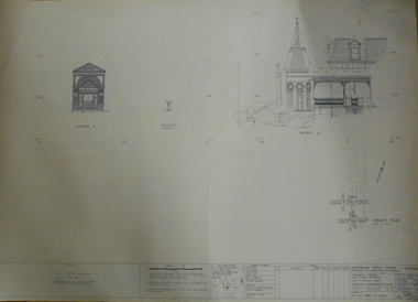
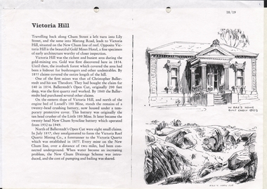
... Open Cut... Lansell's 180 Mine... Little 180 Mine... New Chum Syncline Battery... Victoria Reef Quartz Mining...History House 11 Mackenzie Street Bendigo goldfields BENDIGO History long gully history group The Long Gully History Group - Victoria Hill Gold Mines Hotel Christopher Ballerstedt Theodore Ballerstedt Ballerstedt's Open Cut Lansell's 180 Mine Little 180 Mine New Chum Syncline Battery Victoria Reef Quartz Mining Co Victoria Quartz New Chum Drainage Scheme A Roberts and Sons Tributors William Rae's Bon Accord Mine and Open Cut William Rae Adventure and Advance open Cuts Central Nell Gwynne Heinz Butcher Shop Three pages numbered 18/19, 20/21 and 22/23 titled Victoria Hill. ...Three pages numbered 18/19, 20/21 and 22/23 titled Victoria Hill. First page has some information on Victoria Hill, a sketch of W Rae's Home and Rae's Open cut. The second page has a map of the Victoria Hill Area showing streets and the New Chum Anticline, a sketch of Ballerstedt's Open Cut and a Key to Victoria Hill Area Map. The third page mentions the Victoria Quartz mine, Tributors and quartz roasting. It also has sketch of a 20 Head Crushing Battery, Victoria Hill.bendigo, history, long gully history group, the long gully history group - victoria hill, gold mines hotel, christopher ballerstedt, theodore ballerstedt, ballerstedt's open cut, lansell's 180 mine, little 180 mine, new chum syncline battery, victoria reef quartz mining co, victoria quartz, new chum drainage scheme, a roberts and sons, tributors, william rae's bon accord mine and open cut, william rae, adventure and advance open cuts, central nell gwynne, heinz butcher shop -
 Bendigo Historical Society Inc.
Document - LONG GULLY HISTORY GROUP COLLECTION: VICTORIA HILL
... Open Cut... Lansell's 180 Mine... Little 180 Mine... New Chum Syncline Battery... Victoria Reef Quartz Mining...History House 11 Mackenzie Street Bendigo goldfields BENDIGO History long gully history group The Long Gully History Group - Victoria Hill Gold Mines Hotel Christopher Ballerstedt Theodore Ballerstadt Ballerstadt's Open Cut Lansell's 180 Mine Little 180 Mine New Chum Syncline Battery Victoria Reef Quartz Mining Co Victoria Quartz New Chum Drainage System W Rae's Home Rae's Open Cut 3 Pages titled Victoria Hill. ...3 Pages titled Victoria Hill. On one side is a sketch of W Rae's Home built in the early 1870's and Rae's Open Cut. Mentioned is a short history of Victoria Hill and the mine of Christopher Ballerstadt and his son Theodore. The remains of a 20 head crushing battery, which was originally the ten head crusher of the Little 180 Mine remains. It later became the twenty head New Chum Syncline Battery. Water became a problem and the New Chum Drainage Scheme was introduced and the cost of pumping and bailing was shared between the mines.bendigo, history, long gully history group, the long gully history group - victoria hill, gold mines hotel, christopher ballerstedt, theodore ballerstadt, ballerstadt's open cut, lansell's 180 mine, little 180 mine, new chum syncline battery, victoria reef quartz mining co, victoria quartz, new chum drainage system, w rae's home, rae's open cut -
 The Beechworth Burke Museum
Photograph, c. 1870
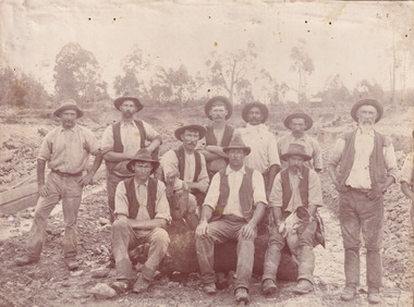
... This group of men are located in a mining location with what appears to be an open cut mine in the background of the image. ...This group of men are located in a mining location with what appears to be an open cut mine in the background of the image. ...This photograph was captured at an undisclosed location and at an unidentified time but likely dates to approximately 1870. The photographer's details are not recorded and the identities of the men in the image are also not known. This image depicts a group of 10 men in typical miners fashion. Four of them are sat on a large log with one holding a small dog. Six miners stand behind those sitting. All these men are wearing a white button-up shirt and tan coloured work trousers. They wear heavy boots and seven have included a dark vest over their shirt. The man holding the dog has a pipe in his mouth. Two of these men are clean shaven with the remainder sporting a moustache and two with a beard. The ages of these men vary from late 20s to middle age. This group of men are located in a mining location with what appears to be an open cut mine in the background of the image. The ground is muddy and has elements which can help identify it as a mining location based on the condition of the landscape. The bottom of the men's trousers are muddy which provides the assurance that these men were working in this location when their photograph was captured. In the background there is one structure, possibly a dwelling, and bush which identifies the location as Australia. Open cut sluicing is a method used to extract gold and other precious metals from beneath the surface of the earth. This technique involved the use of high-powered hoses which broke down the soil enabling miners to come along and search this soil for gold. After the gold rush of the early 1850s, diggers had to enlist the assistance of heavy machinery and techniques like hydraulic sluicing in order to reach gold because the surface alluvial gold had already been discovered and removed. This heavy machinery was not used until after 1853. The search for gold is ingrained into the history of Victoria and therefore, images like this one which portray an open cut sluicing site can reveal important information for society and technology for the date when the photograph was taken. This image is of important historical significance for its ability to convey information about sluicing and the methods used to find gold in the late 1800s and early 1900s. It also shows a location where sluicing was undertook which provides insight into the impact of sluicing on the environment at a time when it was done. Images, like this one, of Australian gold rush history can reveal important information about the social and environmental impact of this period. This image depicts diggers standing in a mining location and therefore, this image has the capacity to reveal or support significant information for researchers studying the fashion and social status of diggers in Australia in approximately 1870. It can also provide information on the landscape of Australia in this period and the impact of mining for gold on both society and the Australian landscape. The Burke Museum is home to a substantial collection of Australian mining photographs which can be used to gain a deeper understanding into life on the gold fields, technology used in mining, the miners themselves and the impact of the gold digging on the environment.Sepia toned rectangular photograph printed on matte photographic paper mounted on board.Reverse: 1997.2518mining, goldfields, beechworth, 1870, australia, australian goldfields, diggers, victoria, sluicing, gold mining, miners, diggers victoria -
 The Beechworth Burke Museum
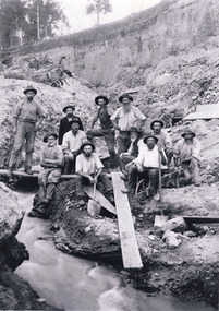
Photograph - Photograph - Reproduction, W. D. Gibbon, Early 1900s
... mining technique that involves directing high pressure water flows at dirt to uncover gold. The technique played a significant role in shaping Beechworth's landscape during the gold rush to create the topography seen today. The search for gold is ingrained into the history of Victoria and therefore, images like this one which portray an open cut ...This photograph was taken in 1911 at Three Mile Creek, about five kilometers south of Beechworth town. Significant digging took place at this location from late 1855, which led to a flood of workers and stores to follow, though daily earnings were slim compared to the nearby Woolshed site. This remained the case even after workers at Three Mile Creek attempted to protest around Beechworth during an election in November 1855. Three Mile Creek was one of seven significant divisions of the Beechworth Mining District formalised by the Governor-in-Council in 1858, though by the time this photograph was taken, the boundaries of the original seven districts had shifted to create seventeen divisions. The Three Mile Goldfields was a site of rich alluvial gold deposits located about 5km south of Beechworth in Victoria. Today, the location of this gold deposit is called Baarmutha. It was a popular area for gold mining in the 1850s but became largely abandoned by the following decade. In 1865, a man named John Pund (a man second from the left in the back row of this photograph shares this surname) recognized that the area could be potentially rich if a better water supply could be obtained. He secured a 15 year license with three other miners. Within the next five years, these men had constructed 19 km of water race going from Upper Nine Mile Creek to Three Mile Creek. By 1881, these four men had delivered 950,000 gallons to the Three Mile Sluicing area which is depicted in this photograph. Pund would later go into partnership with John Alston Wallace who would become owner of the Star Hotel in Beechworth. The Three Mile sluicing location continued to be operational until 1950. The eleven miners in this photograph are: Back row: Led Guthrie, P. Pund, F. Beel, [Unknown] Miller Front row: Paddy McNamara, J. King, W. Beel, [Unknown] Garland, J. Clarke, J. Ryan, H. Bartsh In the background of the photograph is a huge dirt wall that appears to suffer damage caused by hydraulic sluicing. Hydraulic sluicing is a specialised mining technique that involves directing high pressure water flows at dirt to uncover gold. The technique played a significant role in shaping Beechworth's landscape during the gold rush to create the topography seen today.The search for gold is ingrained into the history of Victoria and therefore, images like this one which portray an open cut sluicing site can reveal important information for society and technology for the date when the photograph was taken. This image is of important historical significance for its ability to convey information about sluicing and the methods used to find gold in the late 1800s and early 1900s. It also shows a location where sluicing was undertook which provides insight into the impact of sluicing on the environment at a time when it was done. Images, like this one, of Australian gold rush history can reveal important information about the social and environmental impact of this period. This image depicts diggers standing in a mining location and therefore, this image has the capacity to reveal or support significant information for researchers studying the fashion and social status of diggers in Australia in approximately 1911. It can also provide information on the landscape of Australia in this period and the impact of mining for gold on both society and the Australian landscape. The Burke Museum is home to a substantial collection of Australian mining photographs which can be used to gain a deeper understanding into life on the gold fields, technology used in mining, the miners themselves and the impact of the gold digging on the environment.Black and white / sepia rectangular reproduced photograph printed on glossy photographic paper mounted on board.beechworth, beechworth museum, mining, mining team, three mile creek, sluicing, hydraulic sluicing, photography, gold sluicing, gold mining, pund mining -
 The Beechworth Burke Museum
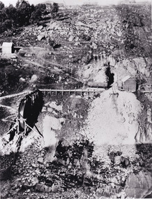
Photograph - Photograph - Reproduction, 1890-1900
... mining being able to continue at Beechworth and may have established world records in tunnelling through hard rock. The entrance at the Gorge side of the tunnel can be seen from the Beechworth Gorge Walk. The tunnel continues to be an outfall drain for the lake and the town. The search for gold is ingrained into the history of Victoria and therefore, images like this one which portray an open cut ...The photograph appears to depict the of the entrance to the Rocky Mountain Tunnel. The Rocky Mountain Tunnel runs from opening of the tunnel, underneath the Beechworth town, to the Gorge. This tunnel drained the excess water from the upper Spring Creek Goldfield to allow for mining access in the area. The Rocky Mountain Co. blasted through the granite rock to create the original 400ft-long tunnel in 1859, but between 1867 and 1871, the Rocky Mountain Gold Sluicing Co. widened and extended it. At its completion, it measured 14ft deep, 6ft wide, and almost half a mile long. The mining surveyor at Beechworth called it 'without doubt, the greatest undertaking of the kind in the colony'. When the company became the Rocky Mountain Extended Gold Sluicing Co. in the mid-1870s, they continued the tunnelling work. The work was reportedly vital to mining being able to continue at Beechworth and may have established world records in tunnelling through hard rock. The entrance at the Gorge side of the tunnel can be seen from the Beechworth Gorge Walk. The tunnel continues to be an outfall drain for the lake and the town.The search for gold is ingrained into the history of Victoria and therefore, images like this one which portray an open cut sluicing site can reveal important information for society and technology for the date when the photograph was taken. This image is of important historical significance for its ability to convey information about sluicing and the methods used to find gold in the late 1800s and early 1900s. It also shows a location where sluicing was undertook which provides insight into the impact of sluicing on the environment at a time when it was done. The Burke Museum is home to a substantial collection of Australian mining photographs which can be used to gain a deeper understanding into life on the gold fields, technology used in mining, the miners themselves and the impact of the gold digging on the environment.A black and white rectangular reproduced photograph printed on matte photographic paper.7814beechworth, beechworth museum, burke museum, australian museum, mining, rocky mountain mining co., rocky mountain mining company, mine, mining company, rocky mountain mine, mine entrance, rocky mountain, gold, gold mining -
 The Beechworth Burke Museum
Photograph, est. 1860-1875
... open-cut sluicing site can reveal important information for society and technology for the date when the photograph was taken. This image is of important historical significance for its ability to convey information about sluicing and the methods used to find gold in 1910. It also shows a location where sluicing was undertaken which provides insight into the impact of sluicing on the environment at a time when it was done. This image of the Rocky Mountain mine is historically significant as the mining ...In 1875, the Rocky Mountain Extended Gold Sluicing Company Ltd was created, utilising the previous Rocky Mountain claim for the area near Lake Sambell. The company employed A.L Martin to survey an area for a tunnel underneath Beechworth and Johnson Stephens to dig it. The tunnel was built at a rate of 40 feet a month and eventually measured 800 metres. The tunnel was a true accomplishment both in the present and during the 19th century. It was considered to be a marvelous engineering feat. Beechworth is renowned for its hydraulic sluice method of mining. This involved soil being exposed to torrents of water from high-pressure hoses. From 1876 until its closure in 1921, the mine produced an astounding 47,926 ozs of gold. Companies like this were the source of income for many Chinese gold-diggers who sought to make their fortune on the goldfields of Beechworth. During the height of the rush, the town had around 7,000 Chinese inhabitants living on the outskirts of town as they were not permitted to live within Beechworth itself.The search for gold is ingrained into the history of Victoria and therefore, images like this one which portrays an open-cut sluicing site can reveal important information for society and technology for the date when the photograph was taken. This image is of important historical significance for its ability to convey information about sluicing and the methods used to find gold in 1910. It also shows a location where sluicing was undertaken which provides insight into the impact of sluicing on the environment at a time when it was done. This image of the Rocky Mountain mine is historically significant as the mining complex is now non-existent, with the only remains being the tunnel built in 1880 by the company, which was considered one of the greatest engineering feats of the time. The image also provides a first-hand look into the social and cultural networks at play during the 19th century with racial segregation of the Chinese at the 'Chinese Camp', as well as an insight into Beechworth's origins during the Gold Rush.A sepia rectangular photograph printed on matte photographic paper as a postcardReverse: Historic Beechworth / 7792.1 / ROCKY MOUNTAIN MINE / Viewed from the “Chinese Camp”, shown partly in the foreground, we see the central plant of the famous Rocky Mountain Mining Company. This extensive complex, of which nothing remains, was situated between Silver Creek and the present Lake Sambell area. The company was responsible for a tunnel cut through solid bedrock underneath the town of Beechworth and surfacing near the keystone bridge on the Wangaratta side. Completed in 1880 it was declared to be one of the greatest engineering feats in Australia. The tunnel is still basically intact today. / Series by Wooragee Graphics: Historic Beechworth. / COPYRIGHT BURKE MUSEUM / No.72 beechworth, rocky mountain mine, sluicing, gold rush, mining, gold -
 The Beechworth Burke Museum
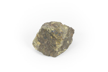
Geological specimen - Chalcopyrite
... This specimen originated from Mount Lyell on the west coast of Tasmania, where a large group of open cut and underground copper-silver-gold mines began operating in 1883. Between 1893-1994, the Mt Lyell Mining and Railway Company were responsible for operations. ...The Beechworth Burke Museum Loch Street Beechworth high-country This specimen originated from Mount Lyell on the west coast of Tasmania, where a large group of open cut and underground copper-silver-gold mines began operating in 1883. Between 1893-1994, the Mt Lyell Mining and Railway Company were responsible for operations. ...This specimen originated from Mount Lyell on the west coast of Tasmania, where a large group of open cut and underground copper-silver-gold mines began operating in 1883. Between 1893-1994, the Mt Lyell Mining and Railway Company were responsible for operations. The Mt Lyell copper-gold mines produce some excellent crystallised specimens of chalcopyrite and other minerals. The deposits are generally considered to be of Cambrian volcanic origin, but there are indications of Devonian granitic influence on the ores, plus local remobilisation during Devonian deformation. Over 120 million tonnes of ore was produced from several workings, including the main Prince Lyell mine and the North Lyell mine, which was also of great importance. The Mount Lyell mines have a long history of human and environmental disasters, including the 1912 North Lyell fire that killed 42 miners, and two separate incidents in 2013 in which three people lost their lives. The environmental impacts from this complex of mines are extensive, with waste tailings and heavy metal contamination flowing directly into the King and Queen River catchments. In 1954, the eminent Australian historian, Geoffrey Blainey, published 'The Peaks of Lyell' which delves into the history of the 1912 North Mount Lyell Disaster.Chalcopyrite does not contain the most copper in its structure relative to other minerals, but it is the most important copper ore since it can be found in many localities and occurs in a variety of ore types. The brassy-yellow colours in Chalcopyrite mean it is often confused with pyrites and gold, leading to use of the term, "fool's gold." Chalcopyrite has been the primary ore of copper since smelting began five thousand years ago. This specimen is part of a larger collection of geological and mineral specimens collected from around Australia (and some parts of the world) and donated to the Burke Museum between 1868-1880. A large percentage of these specimens were collected in Victoria as part of the Geological Survey of Victoria that begun in 1852 (in response to the Gold Rush) to study and map the geology of Victoria. Collecting geological specimens was an important part of mapping and understanding the scientific makeup of the earth. Many of these specimens were sent to research and collecting organisations across Australia, including the Burke Museum, to educate and encourage further study.This hand sized solid mineral specimen has shades of brass-yellow with spots of iridescent green-black tarnish. Chalcopyrite is a copper iron sulphide mineral and a major ore of copper common in sulphide veins and disseminated in igneous rocks. Chalcopyrite has a hardness of 3.5-4 on the Mohs Scale. It is a member of the tetragonal crystal system and has metallic lustre and opaque transparency.burke museum, beechworth, indigo shire, beechworth museum, geology, geological specimen, chalcopyrite, copper pyrites, copper mining, tasmanian geology, mount lyell, mount lyell mines, fools gold, mohs scale, crystals, minerals, historical geological collection, victorian geological survey, a.r.c selwyn, gold rush, van diemans land -
 The Beechworth Burke Museum
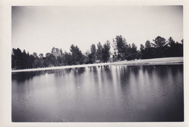
Photograph, 1960s
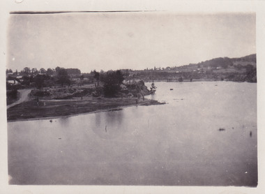
... Mining Company...Forward Beechworth Committee...Beechworth Swimming Club...Wallace Park Lake Sambell Development Scheme...Lake Sambell Caravan Park...Beechworth 1960s...Lake Sambell Swimming Pool...Lake Sambell Boating...Lake Sambell Fishing...Swimming...Boating...Water skiing...Fishing...Post-war prosperity...Minister of Lands...Artificial Lake...Open Cut...Carter Rocky Mountain Mining Company Forward Beechworth Committee Beechworth Swimming Club Wallace Park Lake Sambell Development Scheme Lake Sambell Caravan Park Beechworth 1960s Lake Sambell Swimming Pool Lake Sambell Boating Lake Sambell Fishing Swimming Boating Water skiing Fishing Post-war prosperity Minister of Lands Artificial Lake Open Cut Sluice Mine Lake Reverse: 3534 C798 Black and white rectangle photograph printed on photographic paper and unmounted. ...This photograph was taken in the 1960s at Lake Sambell and is a view across the lake from the east side, the photo was taken during a period of improvements to the lake and surrounding area. Lake Sambell is an artificial lake that was created on the site of the old Rocky Mountain Mining Company workings and was officially opened by Minister for Lands, Mr Baily, on October 5, 1928. The disused and unattractive remains of the mine were converted into a recreational area intended for swimming, boating, and fishing. The lake is named after Mr L.H. Sambell, shire engineer and secretary of the Forward Beechworth Committee, who advocated for the enhancement of Beechworth into a tourist destination and was central to the planning and establishment of the lake. Funding for the project was raised through both competition funds and donations. Since the construction in 1928 several engineering issues have arisen. In 1939 the water levels were low, and the lake was considered both an eyesore and ‘mudhole’, Beechworth Shire Council sort funding to raise the height of the lake six feet to improve the quality of water. Throughout the 1940s the Beechworth Swimming Club sort to address the structural engineering issues and improve swimming facilities at the lake. R.E. Carter, similar to L.H. Sambell, was a shire engineer who advocated the importance of positioning Beechworth as a tourist destination. Carter held the position of shire engineer from 1954-63 and organised many improvements to the Lake Sambell area including the caravan park in 1959, the lake swimming pool in 1961, water skiing and boating facilities, and increased the lake surface area in 1964. These improvements to the lake also reflect an increase in leisure time and access to travel during a period of post-war prosperity in Australia during the 1950s and 60s. This photograph is of historical significance as it documents Lake Sambell in the 1960s after a series of enhancements to the lake area to improve its appearance and usability for both the people of Beechworth and tourists. It is also of social significance in providing an insight into the increase in leisure time and access to travel during a period of post-war prosperity. Black and white rectangle photograph printed on photographic paper and unmounted.Reverse: 3534 C798lake sambell, l.h. sambell, r.e. carter, rocky mountain mining company, forward beechworth committee, beechworth swimming club, wallace park lake sambell development scheme, lake sambell caravan park, beechworth 1960s, lake sambell swimming pool, lake sambell boating, lake sambell fishing, swimming, boating, water skiing, fishing, post-war prosperity, minister of lands, artificial lake, open cut sluice mine, lake -
 The Beechworth Burke Museum
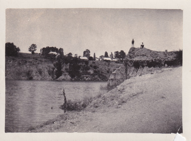
Photograph
... The present day park and reserve occupies the site of the former Rocky Mountain Mining Company, an open-cut sluice mine that began operations in the mid-Nineteenth Century and operated until the early 1900s, through the peak of Victoria’s Gold Rush. ...The present day park and reserve occupies the site of the former Rocky Mountain Mining Company, an open-cut sluice mine that began operations in the mid-Nineteenth Century and operated until the early 1900s, through the peak of Victoria’s Gold Rush. ...The photograph depicts two young men standing atop a prominent outcrop at Lake Sambell, with buildings visible on the further shore. The present day park and reserve occupies the site of the former Rocky Mountain Mining Company, an open-cut sluice mine that began operations in the mid-Nineteenth Century and operated until the early 1900s, through the peak of Victoria’s Gold Rush. It was converted into a park and leisure area in the 1920s. Lake Sambell was formally opened to the public on Friday 5th October 1928 and was opened by the Victorian Government’s Minister of Lands, Mr Bailey, as part of initiatives to boost the economies and development of country towns. The lake was named after Mr L.H. Sambell, a shire engineer and secretary of the Forward Beechworth Committee who was involved in promoting the transformation of the mining site and promoting plantation forestry and tourism as alternative industries. £300 to begin the process was provided by Mr J. McConvill, a former resident of Beechworth, who is remembered in a street name adjacent to the lake. An article in the Ovens and Murray Advertiser on Saturday, 5th May, 1917, gives some insight into issues in the Rocky Mountain Mining Company’s final years. The writer details the 1917 annual meeting of the Rocky Mountain Mining Company, stating that locals present appeared ‘well pleased this important local industry is in such a prosperous condition and that future prospects are so encouraging’. The author describes plans to give workers a bonus as evidence of profit-sharing that would ‘bridge the gulf between capital and labour’. The article concludes, however, with the statement that ‘there is a little arithmetical puzzle in the report in connection with the dredging operations I have been unable to solve.' The photograph is significant as it contributes to knowledge about how Beechworth reinvented itself after the Gold rush period, and more broadly how country towns repurpose and redevelop infrastructure and facilities to meet the present needs of their population. Sepia rectangular photograph printed on matte photographic paper. Obverse: nil. Reverse: 3471 / Velox (paper mark)beechworth, beechworth lake, lake sambell, l.h. sambell, mcconvill, rocky mountain mining company, rocky mountain mining co, minister of lands, forward beechworth committee, wallace park-lake sambell development scheme, wallace park lake sambell development scheme, lake, sambell, j. mcconvill, recreation, reserve, park, transformation, repurposed, redeveloped -
 The Beechworth Burke Museum
Photograph, c1960
... The present day park and reserve occupies the site of the former Rocky Mountain Mining Company, an open-cut sluice mine that began operations in the mid-Nineteenth Century and operated until the early 1900s, through the peak of Victoria’s Gold Rush. ...The present day park and reserve occupies the site of the former Rocky Mountain Mining Company, an open-cut sluice mine that began operations in the mid-Nineteenth Century and operated until the early 1900s, through the peak of Victoria’s Gold Rush. ...The photograph depicts a view across the water at Lake Sambell. The image dates from approximately 1960. The present day park and reserve occupies the site of the former Rocky Mountain Mining Company, an open-cut sluice mine that began operations in the mid-Nineteenth Century and operated until the early 1900s, through the peak of Victoria’s Gold Rush. It was converted into a park and leisure area in the 1920s. Lake Sambell was formally opened to the public on Friday 5th October 1928 and was opened by the Victorian Government’s Minister of Lands, Mr Bailey, as part of initiatives to boost the economies and development of country towns. The lake was named after Mr L.H. Sambell, a shire engineer and secretary of the Forward Beechworth Committee who was involved in promoting the transformation of the mining site and promoting plantation forestry and tourism as alternative industries. £300 to begin the process was provided by Mr J. McConvill, a former resident of Beechworth, who is remembered in a street name adjacent to the lake. Residents of Beechworth have worked to raise funds to improve the Lake Sambell reserve several times, such as efforts in the 1930s and 1940s to raise the banks several feet to deepen the water for swimming purposes. Fundraising campaigns include the ‘Ugly Man’ competition conducted on behalf of the Wallace Park-Lake Sambell Development Scheme. The latter competition was run by the Fire Brigade Bend’s team as part of a larger competition called the ‘Mile of Pennies’; it was won by Mr Len Knight of Beechworth’s Commercial Hotel. The ‘Mile of Pennies’ was conducted at a Carnival held on New Year’s Eve, 1947. It was proposed by the Beechworth and District Progress Association. As well as improving swimming facilities, funds were raised to install a caravan park facility near the lake. Funds were also donated by commercial entities, such as £250 received from Zwar Bros. Pty Ltd. The photograph is significant as it shows the level of development of Beechworth in the early to mid-Twentieth Century. Sepia rectangular photograph printed on matte photographic paperObverse: nil. Reverse: 3470 / Velox (paper mark)beechworth, beechworth lake, lake sambell, lake, beechworth and district progress association, forward beechworth committee, ugly man, mile of pennies, wallace park lake sambell development scheme, wallace park-lake sambell development scheme, zwar bros, zwar, l.h. sambell, j. mcconvill, minister of lands, commercial hotel, len knight, rocky mountain mining company, rocky mountain mining co, gold rush, redevelopment, transformation, community fundraising -
 The Beechworth Burke Museum
Photograph, c1960
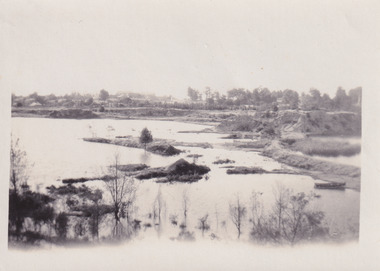
... The present day park and reserve occupies the site of the former Rocky Mountain Mining Company, an open-cut sluice mine that began operations in the mid-Nineteenth Century and operated until the early 1900s, through the peak of Victoria’s Gold Rush. ...The present day park and reserve occupies the site of the former Rocky Mountain Mining Company, an open-cut sluice mine that began operations in the mid-Nineteenth Century and operated until the early 1900s, through the peak of Victoria’s Gold Rush. ...The photograph depicts a view across the water at Lake Sambell. The image is thought to date from the 1960s so may show the lake during a period of drought, such as that experienced across South-Eastern Australia in 1967. The present day park and reserve occupies the site of the former Rocky Mountain Mining Company, an open-cut sluice mine that began operations in the mid-Nineteenth Century and operated until the early 1900s, through the peak of Victoria’s Gold Rush. It was converted into a park and leisure area in the 1920s. Lake Sambell was formally opened to the public on Friday 5th October 1928 and was opened by the Victorian Government’s Minister of Lands, Mr Bailey, as part of initiatives to boost the economies and development of country towns. The lake was named after Mr L.H. Sambell, a shire engineer and secretary of the Forward Beechworth Committee who was involved in promoting the transformation of the mining site and promoting plantation forestry and tourism as alternative industries. £300 to begin the process was provided by Mr J. McConvill, a former resident of Beechworth, who is remembered in a street name adjacent to the lake. Residents of Beechworth have worked to raise funds to improve the Lake Sambell reserve several times, such as efforts in the 1930s and 1940s to raise the banks several feet to deepen the water for swimming purposes. Fundraising campaigns include the ‘Ugly Man’ competition conducted on behalf of the Wallace Park-Lake Sambell Development Scheme. The latter competition was run by the Fire Brigade Bend’s team as part of a larger competition called the ‘Mile of Pennies’; it was won by Mr Len Knight of Beechworth’s Commercial Hotel. The ‘Mile of Pennies’ was conducted at a Carnival held on New Year’s Eve, 1947. It was proposed by the Beechworth and District Progress Association. As well as improving swimming facilities, funds were raised to install a caravan park facility near the lake. Funds were also donated by commercial entities, such as £250 received from Zwar Bros. Pty Ltd.The photograph is significant as it shows Lake Sambell at lower water levels, such as may have been experienced during period of drought.Sepia rectangular photograph printed on matte photographic paperObverse: nil Reverse: 3470beechworth, beechworth lake, lake sambell, lake, beechworth and district progress association, forward beechworth committee, ugly man, mile of pennies, wallace park lake sambell development scheme, wallace park-lake sambell development scheme, zwar bros, zwar, l.h. sambell, j. mcconvill, minister of lands, commercial hotel, len knight, rocky mountain mining company, rocky mountain mining co, gold rush, redevelopment, transformation, community fundraising, drought, 1967, 1960s