Showing 3 items matching "opossum gully"
-
 Bendigo Historical Society Inc.
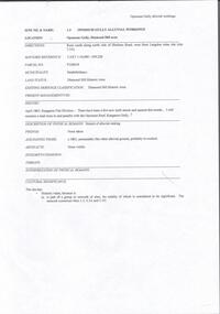
Document - OPOSSUM GULLLY ALLUVIAL WORKING, DIAMOND HILL
... ...opossum gully...One page document detailing location and description of physical mining remains in Opossum Gully, Diamond Hill Historic area....History House 11 Mackenzie Street Bendigo goldfields BENDIGO Mining opossum gully One page document detailing location and description of physical mining remains in Opossum Gully, Diamond Hill Historic area. ...One page document detailing location and description of physical mining remains in Opossum Gully, Diamond Hill Historic area.bendigo, mining, opossum gully -
 Bendigo Historical Society Inc.
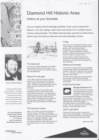
Document - DIAMOND HILL HISTORIC AREA PARKS VICTORIA
... On second page is a map of the area showing historic features: Deborah Consolidated Gold workings Red, White and Blue Extended gold workings Goldfields Extended gold workings Dead Dog Gully, alluvial gold workings Glasgow & Golconda Gold workings and tramway Surface gold mining site Hansel Mundy gold workings Bendigo Goldfields Pty gold workings Stafford gold workings Langdon gold workings Great Opossum Gully alluvial gold workings...On second page is a map of the area showing historic features: Deborah Consolidated Gold workings Red, White and Blue Extended gold workings Goldfields Extended gold workings Dead Dog Gully, alluvial gold workings Glasgow & Golconda Gold workings and tramway Surface gold mining site Hansel Mundy gold workings Bendigo Goldfields Pty gold workings Stafford gold workings Langdon gold workings Great Opossum Gully alluvial gold workings Document DIAMOND HILL HISTORIC AREA PARKS VICTORIA ...Document, two pages, prepared by Parks Victoria in relation to the Diamond Hill Historic Area. Contains information regarding the history of the area; German Miners; Plants and animals. On second page is a map of the area showing historic features: Deborah Consolidated Gold workings Red, White and Blue Extended gold workings Goldfields Extended gold workings Dead Dog Gully, alluvial gold workings Glasgow & Golconda Gold workings and tramway Surface gold mining site Hansel Mundy gold workings Bendigo Goldfields Pty gold workings Stafford gold workings Langdon gold workings Great Opossum Gully alluvial gold workingsbendigo, mining, diamond hill -
 Bendigo Historical Society Inc.
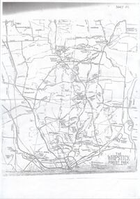
Map - Whipstick Southern Section, Unknown
... Map shows gullies - Beezlebub, Napoleon, Whitehorse, Opossum, Wellington, Red Jacket, Blackhorse, and Centipede. ...Map shows gullies - Beezlebub, Napoleon, Whitehorse, Opossum, Wellington, Red Jacket, Blackhorse, and Centipede. ...The Whipstick forest is now part of the Greater Bendigo National Park. During the goldrush era it was heavily mined with many remnants of the former mines evident. The park protects an area of high-quality Box-Ironbark forest, as well as broombush mallee, grassy woodlands and Kamarooka mallee. The park comes alive with native wildflowers in Spring, and is home to an array of wildlife including Swift Parrots and other bushland birds. Parks Vic: https://www.parks.vic.gov.au/places-to-see/parks/Greater-Bendigo-National-Park Photocopy of maps: 1. 'The Whipstick Forest Park, southern section'. Map shows gullies - Beezlebub, Napoleon, Whitehorse, Opossum, Wellington, Red Jacket, Blackhorse, and Centipede. Mine sites and other significant features are marked including the Whipstick Diggings Settlement near Shadbolt Reserve. Mine sites are identified. 2. Huntly map showing allotments and gullies - Snowball Gully, Deadhorse Gully Nuggety Gully, and Scotchmans Gully are printed in large text on the map. whipstick forest, whipstick, gullies, gold mining, gold