Showing 49 items matching "orion road"
-
 Whitehorse Historical Society Inc.
Document, Julia Marion Harvey Hale, 1907 - 1964
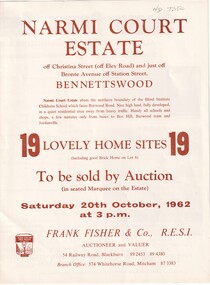
... ...orion road...Biography of the life of Julia Hale, Victoria's most prominent woman sawmiller who from 1941 lived at Buckanbe, 32 Orion Road, Vermont....Whitehorse Historical Society Inc. 2-10 Deep Creek Road Mitcham melbourne hale julia orion road vermont no. 32 kirkpatrick alfred buckanbe park evans peter s. ...Biography of the life of Julia Hale, Victoria's most prominent woman sawmiller who from 1941 lived at Buckanbe, 32 Orion Road, Vermont.hale, julia, orion road, vermont no. 32, kirkpatrick, alfred, buckanbe park, evans, peter s. -
 Whitehorse Historical Society Inc.
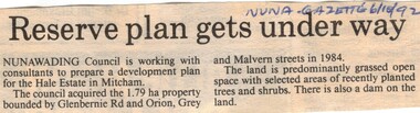
Article, Reserve plan gets under way, 6/10/1992 12:00:00 AM
... road...orion street...Whitehorse Historical Society Inc. 2-10 Deep Creek Road Mitcham melbourne hale estate mitcham glenburnie road orion street vermont grey street malvern street land subdivision Article on the development plan Article on the development plan of the Hale Estate, Mitcham. ...Article on the development planArticle on the development plan of the Hale Estate, Mitcham.Article on the development planhale estate, mitcham, glenburnie road, orion street, vermont, grey street, malvern street, land subdivision -
 Eltham District Historical Society Inc
Photograph - Digital Photograph, Alan King, Yarrambat Heritage Museum, 23 January 2008
... The museum includes the original Yarrambat Primary School, which was moved to the site in 2000 and now serves as the Yarrambat Historical Society headquarters.The museum also includes a fully operational battery (gold-bearing ore crusher) driven by a McDonald 30HP diesel engine built in Richmond in 1938. The battery was relocated from the Golden King Mine in North Oatlands Road, Yarrambat, where it operated until 1984.1 Other exhibits include farming implements and machinery from the Yarrambat district. ...The museum includes the original Yarrambat Primary School, which was moved to the site in 2000 and now serves as the Yarrambat Historical Society headquarters.The museum also includes a fully operational battery (gold-bearing ore crusher) driven by a McDonald 30HP diesel engine built in Richmond in 1938. The battery was relocated from the Golden King Mine in North Oatlands Road, Yarrambat, where it operated until 1984.1 Other exhibits include farming implements and machinery from the Yarrambat district. ...Original Yarrambat Primary School building at the Yarrambat Heritage Museum, Yarrambat Park. At the museum, visitors can gain an insight into Yarrambat’s past since non-Aboriginal settlement. The museum includes the original Yarrambat Primary School, which was moved to the site in 2000 and now serves as the Yarrambat Historical Society headquarters.The museum also includes a fully operational battery (gold-bearing ore crusher) driven by a McDonald 30HP diesel engine built in Richmond in 1938. The battery was relocated from the Golden King Mine in North Oatlands Road, Yarrambat, where it operated until 1984.1 Other exhibits include farming implements and machinery from the Yarrambat district. Published: Nillumbik Now and Then / Marguerite Marshall 2008; photographs Alan King with Marguerite Marshall.; p25This collection of almost 130 photos about places and people within the Shire of Nillumbik, an urban and rural municipality in Melbourne's north, contributes to an understanding of the history of the Shire. Published in 2008 immediately prior to the Black Saturday bushfires of February 7, 2009, it documents sites that were impacted, and in some cases destroyed by the fires. It includes photographs taken especially for the publication, creating a unique time capsule representing the Shire in the early 21st century. It remains the most recent comprehenesive publication devoted to the Shire's history connecting local residents to the past. nillumbik now and then (marshall-king) collection, yarrambat heritage museum, yarrambat historical society, yarrambat primary school -
 Eltham District Historical Society Inc
Photograph, Tess Justine (Nillumbik Shire Council), Murray's Bridge over the Diamond Creek, Eltham North, 19 Feb 2022
... Road bridge in 1958 just months after completion. Murray’s bridge was reinforced with steel some 30 years ago presumably to provide additional floodwater resistance, given the history of bridges disappearing in floodwaters. • In March 1932 it was reported in the Advertiser that there were still some prospectors operating around Eltham North who apart from further scarring the face of the earth over the previous two years had gained significant experience but little gold - hardly a driving factor for constructing a dedicated railway siding and bridge to transfer gold ore. ...Road bridge in 1958 just months after completion. Murray’s bridge was reinforced with steel some 30 years ago presumably to provide additional floodwater resistance, given the history of bridges disappearing in floodwaters. • In March 1932 it was reported in the Advertiser that there were still some prospectors operating around Eltham North who apart from further scarring the face of the earth over the previous two years had gained significant experience but little gold - hardly a driving factor for constructing a dedicated railway siding and bridge to transfer gold ore. ...Murray's Bridge over the Diamond Creek on the Diamond Creek Trail just prior to demolition and replacement with a new steel bridge. Heritage advice obtained by Nillumbik Shire Council, following a suggestion by the Eltham District Historical Society (EDHS), is that the original bridge appears to have been a simplified version of the Country Roads Board’s (CRB) standard timber bridge design of the early-to-mid 1920s. In c1990 Murray’s bridge was renovated with three recycled steel girders as part of a bike/pedestrian path in the reserve. During these alterations many parts of the bridge were removed, and some were replaced. Heritage advice indicates the condition of Murray’s bridge is poor. The remaining original parts are all in poor condition, with severe weathering, splitting and rot, especially to the stringers retained on the bridge. Heritage advice is that Murray’s Bridge does not have sufficient significance in the cultural history of the Nillumbik area to warrant inclusion in the Nillumbik Shire Heritage Overlay and also does not have sufficient significance as a rare survivor to warrant inclusion in the Nillumbik Shire Heritage Overlay. There are no indications in the historical record that this site was individually important to the cultural history of this area. EDHS is comfortable with the heritage advice provided to Council and has worked closely on this project with Council. EDHS has suggested some of the removed timbers be used in the vicinity of the bridge for landscaping and possibly seating, so as to retain these remnants close to the site of the original bridge, which is the last old timber bridge along the lower reaches of the Diamond Creek. Mary (Sweeney) Murray and John Wright Murray selected 80 acres, Lot C Section 16 and Lot 5 Section 17 Parish of Nillumbik, under an occupation license in 1866. John died in 1867 and freehold was granted to his son John in 1873. The farm was known as ‘Laurel Hill’. John Junior was an Eltham Shire councillor and sometime president from 1887 up until 1897. He added Lot A Section 16 to the farm in ca1888. John and his younger brother James arranged to rent/purchase Lot B Section 17, across Diamond Creek to the west, in ca1900. It appears that John and James farmed separately for a few years, with a new homestead built for James ad family on the high point of Lot B Section 17 in ca1910. John sold off Lot 5 Section 17 in 1912. When John died in 1912 James took over the land on both sides of the Diamond Creek. The old homestead on the west side of the Creek disappeared. A farm bridge over Diamond Creek from this period may have been located close to the northern boundary of the farm. John Langlands, owner of the farm known as ‘Ihurst’ on the west side of Diamond Creek to the south of the Murray’s land, died in 1907. In 1909 his land was then subdivided into 100 lots to become the ‘Glen Park Estate’. Other similar subdivisions of nineteenth century farms around Eltham in this period included the ‘Franktonia (or Beard’s) Estate’ to the northeast and ‘Bonsack’s Estate’ between Eltham and Greensborough. Soon after the opening of the railway extension line from Eltham to Hurstbridge in 1912, Glen Park and nearby residents including James Murray agitated for a railway station or siding to be located half-way between Eltham and Hurstbridge, so that the Glen Park residents who used the railway daily did not have to walk into the Eltham or Hurstbridge stations. Some believed Coleman’s Corner (opposite Edendale Farm) was an appropriate spot for the platform. James Murray was among those who thought the railway should be located on his land, closer to half-way between Eltham and Hurstbridge stations. The Railways Commissioners warned that the locals would have to fund these works themselves. The Glen Park Estate residents initially had difficulty accessing Eltham by road, with only an old low-level bridge over Diamond Creek at the south end of their estate. A new timber trestle bridge across the creek, now on Wattletree Road, was opened in 1915. Road access to the north was gained in 1927 when the new Murray’s Road, which crossed the Murray’s land, was built. Residents continued to agitate for a Glen Park station. By 1926 the Railways Commissioners’ preferred site was on the Murray’s land. They arranged an estimate of cost of a full-length platform. The estimate was too much for the locals, who in 1928 argued unsuccessfully for a shorter and hence cheaper platform. By 1929 Murray had agreed to donate the land, but the locals would still have to fund the works. Murray decided, unilaterally it would appear, to commence work on a timber trestle road bridge over Diamond Creek to link the new Murray Road to the proposed station. Late in 1929 he stopped work on the bridge, for reasons unknown, but started work again and completed the bridge in 1931. There is no further newspaper evidence of the campaign for the Glen Park station until 1939, when Murray and another local, Mr Maxwell, met the Railways Commissioner. The Glen Park locale now included 45 homes on the west side of the creek and 20 on the Eltham side. Most of the residents used the train every day. The Commissioner remained adamant that only a full-length platform could be built for safety reasons. It appears the campaign dissolved at this point. The increasing move to cars may have had an impact. There is no evidence of Murray’s bridge ever being connected to Murray’s Road, or of it having wide use for any purpose by locals. James Murray died in 1947 and the farm was taken over by his son James (Jim). Jim started to sell off parts of the farm in the 1980s, retaining a few acres around the ca1910 homestead and building a new house there. Recreation reserves were established along the creek. In ca1990 Murray’s bridge was renovated with steel girders as part of a bike/pedestrian path in the reserve. The old farmhouse was demolished in ca2014. * * * A theory posted on local community Facebook groups was that the bridge was built in the 1860s and was built to be more robust than was necessary for the movement of cows from one side of the creek to the other. It was suggested the robustness was necessary to support the weight of gold ore being transferred from a mine on Murray’s land to a railway siding near Murrays Bridge (presumably for transfer and processing at Diamond Creek). Perhaps this may have been one of the motivators for Murray, who really knows? Knowing when mining operations ceased on his land and how that fits the overall timeline would be useful but at the time the bridge was built, local gold production was minimal at best. The known facts are: • The railway line came to Eltham in 1902. • The extension of the railway from Eltham to Hurstbridge was constructed in 1912 so no railway line even existed through Murray's property until 1912 and the Victorian Railways maps at the time show no such siding on Murray’s property. • In 1923 a new company was formed in anticipation of the old Diamond Creek Gold Mine being re-opened. The mine had been previously closed and flooded. It was noted in the press at the time that the mine was within a mile of the railway. Nothing really came of this. • Construction of Murrays Bridge was commenced by James Murray in early 1929 in anticipation of a proposed flag station being nominated on his land, but work ceased shortly afterwards. The proposed flag station was commonly referred to as Glen Park as the residents of the Glen Park Estate wanted Option 1, located near them with the platform adjacent to Colemans corner. This was probably never going to fly as it was virtually in eyesight of Eltham station. Allandale Road was the third option, but the Commissioners' preferred option was No. 2 - on Murray's property. • The Railway Commissioners were not going to finance any such station and the works had to be funded by private landowners and residents, hence Murray investing in this himself. • Murray recommenced work two years later and finished his bridge in 1931 but unfortunately for him, the proposed flag station never eventuated. The bluestone siding you reference may well have been built by Murray as part of the proposed station platform. • Up until then, apart from the Main Road bridge, which was washed away in 1924, virtually all local crossings over the Diamond Creek were low lying bridges – Kaylocks Bridge at Brougham Street, Diamond Street bridge, Glen Park Road bridge. It is expected that Murray also had a low-lying bridge to connect his land either side of the creek. These were all washed away or severely damaged multiple times in the 1920s. Lessons were learnt, and Murrays Bridge appears to have been built in accordance with Country Road Board standards of the time. Flood damage was ongoing, and even more recently constructed raised bridges kept getting washed away, e.g., the new Wattle Tree Road bridge in 1958 just months after completion. Murray’s bridge was reinforced with steel some 30 years ago presumably to provide additional floodwater resistance, given the history of bridges disappearing in floodwaters. • In March 1932 it was reported in the Advertiser that there were still some prospectors operating around Eltham North who apart from further scarring the face of the earth over the previous two years had gained significant experience but little gold - hardly a driving factor for constructing a dedicated railway siding and bridge to transfer gold ore. It is far more probable that James Murray was hoping to have the railway station located on his property and invested his money by building the bridge to lead to it as well as a station platform. Had the station eventuated, it may well have driven up the value of his land for subdivision and new housing estates like the Glen Park Estate. That did not eventuate. Whilst the bridge was indeed old (90 years), the core structure being completed in 1931, it had been modified substantially from original and hence had no significant historic value – i.e., it was not a representative example of its type, construction, and age. Given that the bridge was not worthy of saving, the Eltham District Historical Society with Council’s support, and the Eltham Woodworkers group endeavoured to see what suitable sized timbers were salvageable to fabricate a commemorative seat. Unfortunately, the experts at the Woodworkers group were unable to salvage any suitable length/width timbers to fabricate the seat due to the presence of rot. Last remaining wooden trestle bridge on the Diamond Creek Trail just prior to demolition and replacementBorn digital image (27)diamond creek (creek), diamond creek trail, murrays bridge, ‘laurel hill’, john wright murray, mary (sweeney) murra, john murray jnr, james murray, john langlands, ‘ihurst’, ‘glen park estate’, beard's estate, franktonia, bonsack's estate, glen park estate, glen park railway station -
 Glen Eira Historical Society
Letter - Rosstown Railway
... RETURN TO ROSSTOWN: RAILWAYS LAND SALES AND SUGAR BEET VENTURES IN CAULFIELD Land Sales Walking Trails Ross William Murray Transport Objects Locomotion Walking Cycling Driving Sports Country Mansions People Caulfield John Builders Construction and Demolition Workers Occupations Careers Professionals Topography Geology Landforms Horticulture Market Gardens Primary Industry Workers City of Caulfield MOOD KEE Pennington Harold Annual General Meetings Caulfield Town Hall Glen Eira City Council Carnegie Carnegie Station Rosstown Station People by Circumstance Migrants Sugar Beet Sugar Beet Mill Sugar Beet Industry Mills Factories SEA BEACH LINES Bent Thomas Parliamentary Representatives Neville Street Miller Street Lemann’s Swamp Reserve Koornang Park Cane Sugar Industry Breweries Rabbit Processing Plants Health Establishments Hospitals Food Production Establishments Abattoirs Thieves Social Problems Vagrants Theft Squatting Financial Economics Debt Finance Industry Insurance Companies Company Managers Bentleigh Ross Leila THE GRANGE Leila Road Wild Cherry Road Financial Trouble Mortgages Gisborne Street Archibald Street Riddell Parade VICTORIA RAILWAYS Glen Huntly Road Clarence Street College Street Gladstone Parade Parrell Street Aileen Avenue Seaview Street Land Subdivisions Dover Street Sussex Street Landfill Marara Road Booran Road Woodville Avenue Dorothy Avenue Ormond Park Royal Avenue Ormond Railway Station Oakleigh Road Melten Avenue Miller Street Munro Avenue Lord Reserve Neerim Road Toolambool Road The Rosstown Hotel Rosanna Street Murrumbeena Crescent Commercial Establishments The National Bank Rosstown Road Kangaroo Road Poath Road Freda Street Hughesdale Kindergarten Oakleigh Council Hughesdale Community Centre Civic Establishments Galbally Reserve Plaques Warrigal Road OUT AND ABOUT BROCHURES Orion Estate Letter Rosstown Railway ...This file contains four items: 1/A black and white photocopy of a letter dated either 07/08/1889 or 09/08/1889, from Robert Lundon to an unidentified recipient discussing an agreement reached between the author – on behalf of the recipient – and Soon Hang Hi in regard, in regards to the allotment known as Webber’s. The agreement is outlined in the letter in what appears to be Chinese characters, and includes the marks of Robert Lundon and Soon Hang Hi. File note from Joy Wu states that the calligraphy is not Mandarin or traditional Chinese. 2/Three sheets of hand-written working notes with information taken from the Victorian Government Gazette on THE ROSSTOWN AND MURRUMBEENA LAND COMPANY LIMITED, THE ROSSTOWN JUNCTION RAILWAY AND PROSPERITY COMPANY LIOMITED, and THE ROSSTOWN JUNCTION, ELSTERNWICK, AND OAKLEIGH RAILWAY COMPANY LIMITED, covering dates between 1887 and 1894. The notes concern meetings and creditors claims relevant to the companies, with reference numbers for the information source. Date and author of the notes are not recorded. 3/A black and white photocopy of the a partial map of the Rosstown Railway and surrounding area, undated. The map includes the names of landholders in the areas of Brighton, Garden Vale and Elsternwick, as well as other railway lines present in the region. 4/A fold-out map and guide of the Rosstown Rail Trail, including a brief general history of Caulfield as well as a more extensive biography of William Murray Ross and the Rosstown Railway. The map marks and describes significant sites along the trail, including photographs of some of these sites, provided by DF Jowett.documents, correspondence, webber’s, lundon robert, chinese characters, ethnic communities, signatures, text, settlements, taxes, fraser john grieves, lovell r.h., price davies, meetings, communication activities, soon hang hi, commercial events and activities, the rosstown and murrumbeena land company limited, victorian government gazette, bulmer richard, parry john, osment henry, shareholders, creditors claims, the rosstown junction railway and property company limited, finch and best, lawyers, the rosstown junction elsternwick and oakleigh railway company limited, cameron w.c., phillips p.d., garden vale, elsternwick, elsternwick railway station, rosstown, rosstown railway, thomas street, bay street, kooyong road, melbourne and brighton railway, hawthorn road, bambra road, caulfield and frankston railway, booran road, grange road, koornang road, murrumbeena road, north road, north road railway station, east brighton railway station, south road, railway routes, railway lines, railways, land transport, murphy j., caulfield, hamilton t.f., dane p., holloway, webb, ailee john, payne t.b., brodie chas, dane john, o’neil h., mccombie john, mcmillane a., smyth c.d., cooper, ebden, landholders, jeffrey j.d., gill j., balcombe a.e., cooper h., mcnab j., white j., sutherland j., greeves a.f.a., newton m.c., chamley f.b., fowler j., inglis p., grant t., stooke j., swanson g., cochrane c., adams e.b., mccombie thas, keyes robert, brighton cemetery, burials grounds and graveyards, war-ein road, were j.b., holland j., mcmahon c., winter t.l.m., dendy henry, mitchell w., jackson s., were j.e., wickham francis dawe, bryant jane, east brighton railway station, railway stations, maps, allotments, land titles, roads and streets, rosstown rail trail, city of glen eira, tourism, trains, tourism information bureaus, tours, pamphlets, elsternwick railway park, oakleigh junction, princes park, ee gunn reserve, packer park, sites, jowett d.f., weickhardt i.g., return to rosstown: railways land sales and sugar beet ventures in caulfield, land sales, walking trails, ross william murray, transport objects, locomotion, walking, cycling, driving, sports, country mansions, people, caulfield john, builders, construction and demolition workers, occupations, careers, professionals, topography, geology, landforms, horticulture, market gardens, primary industry workers, city of caulfield, mood kee, pennington harold, annual general meetings, caulfield town hall, glen eira city council, carnegie, carnegie station, rosstown station, people by circumstance, migrants, sugar beet, sugar beet mill, sugar beet industry, mills, factories, sea beach lines, bent thomas, parliamentary representatives, neville street, miller street, lemann’s swamp reserve, koornang park, cane sugar industry, breweries, rabbit processing plants, health establishments, hospitals, food production establishments, abattoirs, thieves, social problems, vagrants, theft, squatting, financial economics, debt, finance industry, insurance companies, company managers, bentleigh, ross leila, the grange, leila road, wild cherry road, financial trouble, mortgages, gisborne street, archibald street, riddell parade, victoria railways, glen huntly road, clarence street, college street, gladstone parade, parrell street, aileen avenue, seaview street, land subdivisions, dover street, sussex street, landfill, marara road, booran road, woodville avenue, dorothy avenue, ormond park, royal avenue, ormond railway station, oakleigh road, melten avenue, miller street, munro avenue, lord reserve, neerim road, toolambool road, the rosstown hotel, rosanna street, murrumbeena crescent, commercial establishments, the national bank, rosstown road, kangaroo road, poath road, freda street, hughesdale kindergarten, oakleigh council, hughesdale community centre, civic establishments, galbally reserve, plaques, warrigal road, out and about brochures, orion estate -
Glen Eira Historical Society
Ephemera - Orion Estate
... Orion Estate Elsternwick Mars Street Jupiter Street Venus Street Saturn Street Kooyong Street Mercury Street Rosstown Junction Railway Real Estate Agents Railway Stations Lillie and Davis Auctions Ormond Station Hobsons Bay Elsternwick Station Glenhuntly Road Brighton Line Madden Walter Tunen August Building Surveyors Residential Development Plans Houses Ephemera Orion Estate ...One item about this estate: 1/A black-and-white estate agents notice for the sale of Orion Estate at 3-o-clock on the Saturday 5th December 1880s. This notice details the sale of Orion Estate by public auction into allotments.orion estate, elsternwick, mars street, jupiter street, venus street, saturn street, kooyong street, mercury street, rosstown junction railway, real estate agents, railway stations, lillie and davis, auctions, ormond station, hobsons bay, elsternwick station, glenhuntly road, brighton line, madden walter, tunen august, building surveyors, residential development, plans, houses -
 Eltham District Historical Society Inc
Photograph - Digital Photograph, Alan King, Ore crusher, Golden King mine, Yarrambat, 22 January 2008
... Road closed. It was owned by the Clayton family and in the 1960s was the only private family gold mine in Victoria. Larger mines had their own batteries and stampers to process the ore. ...Road closed. It was owned by the Clayton family and in the 1960s was the only private family gold mine in Victoria. Larger mines had their own batteries and stampers to process the ore. ...Prior to 1929 Yarrambat was known as Tanck's Corner or Reynold's Corner after Frederick Tanck who owned land north of Ironbark Road at the corner of Yan Yean Road, and Thomas Ryenolds who owned the property opposite. Tanck's Corner was at the centre of gold bearing country. Gold was mined here until 1984 when the last operating mine, the Golden King mine in North Oatlands Road closed. It was owned by the Clayton family and in the 1960s was the only private family gold mine in Victoria. Larger mines had their own batteries and stampers to process the ore. Covered under Heritage Overlay, Nillumbik Planning Scheme. Published: Nillumbik Now and Then / Marguerite Marshall 2008; photographs Alan King with Marguerite Marshall.; p23This collection of almost 130 photos about places and people within the Shire of Nillumbik, an urban and rural municipality in Melbourne's north, contributes to an understanding of the history of the Shire. Published in 2008 immediately prior to the Black Saturday bushfires of February 7, 2009, it documents sites that were impacted, and in some cases destroyed by the fires. It includes photographs taken especially for the publication, creating a unique time capsule representing the Shire in the early 21st century. It remains the most recent comprehenesive publication devoted to the Shire's history connecting local residents to the past. nillumbik now and then (marshall-king) collection, battery, clayton family, gold mining, golden king mine, ore crusher, tancks corner. reynolds corner, yarrambat -
 Bendigo Historical Society Inc.
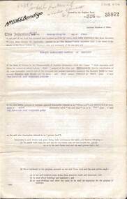
Document - MCCOLL, RANKIN AND STANISTREET COLLECTION: INDENTURE, GOLD MINING LEASE CROWN AND RONALD ALEXANDER RANKIN, BENDIGO, 24th June 1941
... Map shows lease 11166 marked in yellow with shaft, ore bins and tramway marked. Belle Vue Road , Adam Street and Griston Street shown on map...Road Adams Street Griston Street Golden Gully Ronald Alexander Rankin North Deborah Mine. 6 page document, Gold Mining Lease 11166, plus map. Indenture between Crown (King George VI) and Ronald Alexander Rankin of Bendigo, dated 24th June, 1941. Map No. 11166 Bendigo, Mining District of Bendigo, Parish of Sandhurst, County of Bendigo. Map shows lease 11166 marked in yellow with shaft, ore ...6 page document, Gold Mining Lease 11166, plus map. Indenture between Crown (King George VI) and Ronald Alexander Rankin of Bendigo, dated 24th June, 1941. Map No. 11166 Bendigo, Mining District of Bendigo, Parish of Sandhurst, County of Bendigo. Map shows lease 11166 marked in yellow with shaft, ore bins and tramway marked. Belle Vue Road , Adam Street and Griston Street shown on map. ( Golden Gully area) Dams indicated on lease holdings. Other lease holdings: 1675 T.L.9858, 10990, 11013, 11062, 11165, 11063 (void) 1172 W.R. (dam thereon) 9882 (void). Some residential lots marked along Belle Vue Road, and Adam Street. On bottom of map 21.8.41 in pencil. On last page of document : North Deborah Mining Company now the proprietor of the within described estate by transfer registered on 11th November 1914.bendigo, mining, north deborah lease, belle vue road, adams street, griston street, golden gully, ronald alexander rankin, north deborah mine. -
 The Beechworth Burke Museum
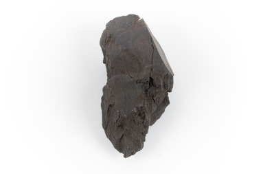
Geological specimen - Brown coal
... Ore Mine. The Lal Lal Iron Mining Company took over operations in 1874, who then peaked iron production in 1884. This mine continued operations until June 1884, when the blast furnace was extinguished and never recommenced. The blast furnace at Lal Lal is considered one of the most important and highly significant sites ion early industrial history in Australia, as it is the only remaining best furnace from the nineteenth century in the Southern Hemisphere. The furnace ruins are 17 metres high, and are clearly visible today on Iron Mine Road...Ore Mine. The Lal Lal Iron Mining Company took over operations in 1874, who then peaked iron production in 1884. This mine continued operations until June 1884, when the blast furnace was extinguished and never recommenced. The blast furnace at Lal Lal is considered one of the most important and highly significant sites ion early industrial history in Australia, as it is the only remaining best furnace from the nineteenth century in the Southern Hemisphere. The furnace ruins are 17 metres high, and are clearly visible today on Iron Mine Road ...This particular specimen was recovered from the Lal Lal Coal and Iron Mine in Victoria, 19km from Ballarat. Brown Coal was discovered here in 1857, just alongside the Geelong to Ballarat Railway line. This discovery of lignite (brown coal) was the first in Victoria, which would bring important benefits to the region and state, both of which had previously been reliant on coal imports. In the 1860s, iron ore was found just 5km from Lal Lal, and the area was converted into an Iron Ore Mine. The Lal Lal Iron Mining Company took over operations in 1874, who then peaked iron production in 1884. This mine continued operations until June 1884, when the blast furnace was extinguished and never recommenced. The blast furnace at Lal Lal is considered one of the most important and highly significant sites ion early industrial history in Australia, as it is the only remaining best furnace from the nineteenth century in the Southern Hemisphere. The furnace ruins are 17 metres high, and are clearly visible today on Iron Mine Road, Lal Lal, near the Bungal Dam. This specimen of Lignite (brown coal) is significant, as it was mined from the area where brown coal was first discovered in Victoria, leading to an important and controversial future of the mining and use of brown coal in this State. The Victorian Heritage Database has listed the Lal Lal Coal Mine with local significance, with their Statement of Significance stating: "The Lal Lal coal mine is historically significant as the site of the first discovery of lignite (brown coal) in Victoria, and one that promised important benefits to regional and state industries that were reliant on coal imports at the time. The significance of the stie is reduced by the poor state of preservation of the coal mining and processing fabric". This specimen is part of a larger collection of geological and mineral specimens collected from around Australia (and some parts of the world) and donated to the Burke Museum between 1868-1880. A large percentage of these specimens were collected in Victoria as part of the Geological Survey of Victoria that begun in 1852 (in response to the Gold Rush) to study and map the geology of Victoria. Collecting geological specimens was an important part of mapping and understanding the scientific makeup of the earth. Many of these specimens were sent to research and collecting organisations across Australia, including the Burke Museum, to educate and encourage further study.A hand-sized light-weight, soft and combustable sedimentary rock specimen, that is dark brown in colour. The specimen has jagged edges, as though parts of the rock have crumbled away. Brown coal, or Lignite, is formed naturally from compressed peat, and is typically found in natural basins. The stages to the formation of coal ('coalification') begin with plant material and wood, which will decay if it is not subjected to deep burial or heating, and turn into Peat. Peat, when sufficiently compressed naturally, will turn into Brown Coal (Lignite), and finally into Black Coal (sub-bituminous, bituminous and anthracite). Each successive stage has a higher energy content and lower water content. It is brownish-black in colour. Brown Coal has a high moisture content, between 50 and 75 percent, and a low carbon content. Some Brown Coals may be stratified, with layers of plant matter, which means little coalification has occurred beyond the peat natural processing stage. When Brown Coal is submerged in dilute nitric acid or boiling potassium hydroxide solution, it reacts to produce a reddish solution, of which higher-ranked coals do not. When brown coal is pulverised and burned in boilers, the steam is used to drive turbines, which generates electricity. It is the lowest rank of coal, as when burned, it creates a relatively low heat content, which in turn does not create a great output of steam. burke museum, beechworth, indigo shire, beechworth museum, geological, geological specimen, mineralogy, brown coal, brown coal specimen, lignite, lal lal, lal lal coal mine, lal lal iron mine, ballarat, blast furnace -
 The Beechworth Burke Museum
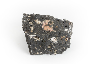
Geological specimen - Basalt, Unknown
... ore which form grains that are indistinguishable to the naked eye. It can be dark grey or black in colouring and sometimes may contain holes left by gas bubbles. Most of the Earth's basalt was produced in environments such as oceanic divergent boundaries, oceanic hotspots, and mantle plumes and hotspots beneath continents. Basalt is commonly used in construction where it is crushed and used for multiple purposes such as concrete aggregate, road...ore which form grains that are indistinguishable to the naked eye. It can be dark grey or black in colouring and sometimes may contain holes left by gas bubbles. Most of the Earth's basalt was produced in environments such as oceanic divergent boundaries, oceanic hotspots, and mantle plumes and hotspots beneath continents. Basalt is commonly used in construction where it is crushed and used for multiple purposes such as concrete aggregate, road ...Basalt is a common igneous rock that composes most of the Earth's surface and can be found on the Moon and other rocky planets of the Solar System. It is generally composed minerals such as calcic plagioclase, clinopyroxene and iron ore which form grains that are indistinguishable to the naked eye. It can be dark grey or black in colouring and sometimes may contain holes left by gas bubbles. Most of the Earth's basalt was produced in environments such as oceanic divergent boundaries, oceanic hotspots, and mantle plumes and hotspots beneath continents. Basalt is commonly used in construction where it is crushed and used for multiple purposes such as concrete aggregate, road base, or railroad ballast. Thin slabs of basalt can also be cut and used for floor tiles, stone monuments, and building veneer. This particular specimen was excavated from Talbot in Victoria, which was a small gold mining town established in 1852. As basalt is a common rock, it is not specific to Talbot. However, this specimen can be assumed to be of the Cainozoic age due to previous geomorphic surveys of the area. This particular type of Basalt was used mainly for roads due to the durability of the rock.Basalt holds significance due to the continued use of the rock from historic until present times. The rock has been utilised for many types of construction and is still used for the same purposes today. Basalt also has significance to the Earth and other rocky planets of the Solar System as it makes up most of the planet's surface. This specimen is part of a larger collection of geological and mineral specimens collected from around Australia (and some parts of the world) and donated to the Burke Museum between 1868-1880. A large percentage of these specimens were collected in Victoria as part of the Geological Survey of Victoria that begun in 1852 (in response to the Gold Rush) to study and map the geology of Victoria. Collecting geological specimens was an important part of mapping and understanding the scientific makeup of the earth. Many of these specimens were sent to research and collecting organisations across Australia, including the Burke Museum, to educate and encourage further study.A smaller than hand sized rock specimen which is dark grey in colour with small holes and white deposits across its surface.Geological survey / [illegible] /burke museum, beechworth, geological specimen, geology, basalt, basalt specemin, indigo shire, talbot, cainozoic, igneous rock -
 Greensborough Historical Society
Photograph - Digital Image, Mystery mine photographs: 10-head stamper battery for crushing ore, 1935c
... Greensborough Historical Society 34A Glenauburn Road Lower Plenty Lower Plenty melbourne 10-head stamper battery for crushing ore. .An interesting collection of photographs, the connection to Greensborough remains a mystery. tasmania mines and mining Photos have no markings or dates. ...10-head stamper battery for crushing ore..An interesting collection of photographs, the connection to Greensborough remains a mystery. Digital copy of 2 black and white photographs, two of 30 photos of mining operations.Photos have no markings or dates. Donor unknown.tasmania, mines and mining -
 Greensborough Historical Society
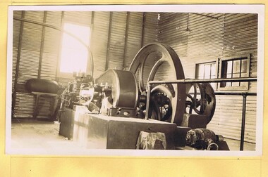
Photograph - Digital Image, Mystery mine photographs: Steam plant for crusher, 1935c
... Greensborough Historical Society 34A Glenauburn Road Lower Plenty Lower Plenty melbourne Steam plant for ore crusher, .An interesting collection of photographs, the connection to Greensborough remains a mystery. tasmania mines and mining mining machinery Photos have no markings or dates. ...Steam plant for ore crusher,.An interesting collection of photographs, the connection to Greensborough remains a mystery. Digital copy of 2 black and white photographs, two of 30 photos of mining operations.Photos have no markings or dates. Donor unknown.tasmania, mines and mining, mining machinery -
 Greensborough Historical Society
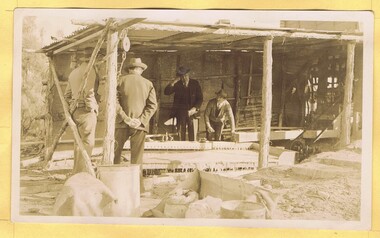
Photograph - Digital Image, Mystery mine photographs: Washing table for ore concentrate, 1935c
... Greensborough Historical Society 34A Glenauburn Road Lower Plenty Lower Plenty melbourne Washing table for ore concentrate. .An interesting collection of photographs, the connection to Greensborough remains a mystery. tasmania mines and mining mining machinery Photos have no markings or dates. ...Washing table for ore concentrate..An interesting collection of photographs, the connection to Greensborough remains a mystery. Digital copy of 2 black and white photographs, two of 30 photos of mining operations.Photos have no markings or dates. Donor unknown.tasmania, mines and mining, mining machinery -
 Greensborough Historical Society
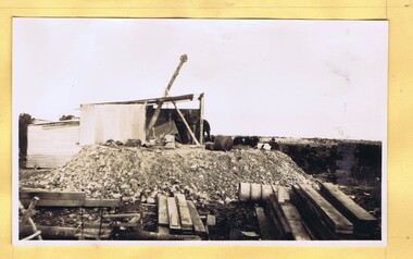
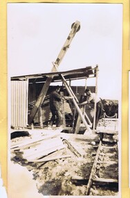
Photograph - Digital Image, Mystery mine photographs: Shaft and pulley, 1935c
... Greensborough Historical Society 34A Glenauburn Road Lower Plenty Lower Plenty melbourne Shaft and pulley bring ore out of mine and tip into cart (two views) .An interesting collection of photographs, the connection to Greensborough remains a mystery. tasmania mines and mining mining machinery Photos have no markings or dates. ...Shaft and pulley bring ore out of mine and tip into cart (two views).An interesting collection of photographs, the connection to Greensborough remains a mystery. Digital copy of 2 black and white photographs, two of 30 photos of mining operations.Photos have no markings or dates. Donor unknown.tasmania, mines and mining, mining machinery -
 Greensborough Historical Society
Photograph - Digital Image, Mystery mine photographs: Shaft and pulley 2, 1935c
... Greensborough Historical Society 34A Glenauburn Road Lower Plenty Lower Plenty melbourne Shaft and pulley bring ore out of mine and tip into cart (two views) .An interesting collection of photographs, the connection to Greensborough remains a mystery. tasmania mines and mining mining machinery Photos have no markings or dates. ...Shaft and pulley bring ore out of mine and tip into cart (two views).An interesting collection of photographs, the connection to Greensborough remains a mystery. Digital copy of 2 black and white photographs, two of 30 photos of mining operations.Photos have no markings or dates. Donor unknown.tasmania, mines and mining, mining machinery -
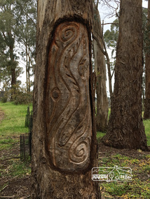 Eltham District Historical Society Inc
Photograph, Peter Pidgeon, Killeavey, Laughing Waters Road, Eltham 5 Nov 2016, 5 Nov 2016
... ore European settlement. The Wurundjeri built the eel trap in an area where the eels gathered and has proven to still be highly effective today Heriitage Excursion - Kileavey Walk and Talk activities eltham district historical society heritage excursion kileavey parks victoria laughing waters road eltham wurundjeri Born Digital Killeavey, Laughing Waters Road, Eltham 5 Nov 2016 Photograph Peter Pidgeon ...This carving represents the eels and eel trap which was discovered by Cam in the Yarra below Killeavey and has been established to be ore European settlement. The Wurundjeri built the eel trap in an area where the eels gathered and has proven to still be highly effective today Heriitage Excursion - Kileavey Walk and TalkBorn Digitalactivities, eltham district historical society, heritage excursion, kileavey, parks victoria, laughing waters road, eltham, wurundjeri -
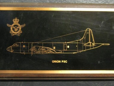 Running Rabbits Military Museum operated by the Upwey Belgrave RSL Sub Branch
Etching
... Running Rabbits Military Museum operated by the Upwey Belgrave RSL Sub Branch 1 Mast Gully Road Upwey melbourne Picture RAAF Orion P3C Etching ...Orion P3Cpicture, raaf -
 Running Rabbits Military Museum operated by the Upwey Belgrave RSL Sub Branch
Photograph (size 5)
... Running Rabbits Military Museum operated by the Upwey Belgrave RSL Sub Branch 1 Mast Gully Road Upwey melbourne Photo RAAF Orion P3 Photograph (size 5) ...Orion P3photo, raaf -
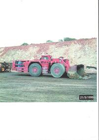 Bendigo Historical Society Inc.
Photograph - Kangaroo Flat Gold Mine Collection: mining equipment, 21st May 1999
... ore, and other materials from the digging face to processing facilities or loading areas. A bogger operator is an individual who controls the machinery used to transport materials. Western Mining Corporation goldmining capping shaft mining regulations Kangaroo Flat Gold Mine 1999 Colour photocopy of original photo. Image shows red load haul dump loader, pictured parked on a mine road ...A bogger is a heavy-duty piece of equipment used in underground mining to transport rocks, ore, and other materials from the digging face to processing facilities or loading areas. A bogger operator is an individual who controls the machinery used to transport materials.Colour photocopy of original photo. Image shows red load haul dump loader, pictured parked on a mine road at the Kangaroo Flat Gold Mine site. Date stamp on bottom RH corner: 21/5/1999.western mining corporation, goldmining, capping, shaft, mining regulations, kangaroo flat gold mine, 1999 -
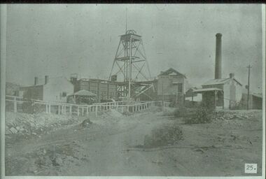
Bendigo Historical Society Inc.
Photograph - MINING IN BENDIGO COLLECTION: MINING PHOTOGRAPHS
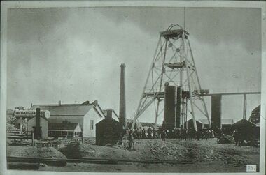
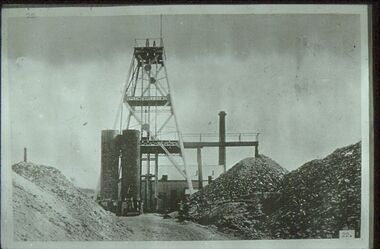
... Road. It shows the mine and its buildings, chimney, ore bins, mullock heap and tramway. ...Road. It shows the mine and its buildings, chimney, ore bins, mullock heap and tramway. ...BHS CollectionFolded paper with copies of photos of mines and various mining buildings. On the front is a view from New Chum Hill, looking south in 1890's. Pictured is the Lazarus Crushing Plant and boiler house, Lansell's '222'. Amd the new Chum Mines in the background. On the inside at the top is the New Chum Railway, Golden Square. Pictured is the mine and its buildings, two chimneys, two large wood stacks and other mines in the background. On the left, a man is standing on the side of the railway line beside the mine. The next picture is the United Hustlers and Redan Mine, west of Comet Hill State School, Sandhurst Road. It shows the mine and its buildings, chimney, ore bins, mullock heap and tramway. The middle picture is the Central Deborah, Violet Street, near Bendigo Creek, Golden Square. It shows the poppet legs, buildings and some machinery behind the large building. The large building has eight ventilators in the roof. The buildings are made of corrugated iron. The bottom left picture is the Deborah Mine, Quarry Hill. The picture shows the poppet legs on the hilltop, the buildings beside it, a square chimney behind the poppet legs and some vegetation and a peppercorn tree in the foreground. The far building also has ventilators in the roof. The picture on the right is underground at 1000 feet level in the Deborah Mine. Pictured are three men with a rock drill. On the back, at the top is a picture of a First Motion Winding Engine at Deborah - later at Central Deborah. The picture shows the engine and driver. The middle picture is the South New Moon Mine, Eaglehawk - leading mine in State in 1903. The picture shows the poppet legs, buildings, chimney and a high tramway. In the foreground is a dam. The bottom picture is Victoria Hill looking south to New Chum Hill. In the foreground is Lansell's '180' Mine and Ballerstedt's Open Cut and in the background are the 'New Chum and Victoria', 'Old Chum' and the 'North Old Chum'.photo, mining in bendigo, mining photographs, lazarus crushing plant, lansell's 222, new chum mines, new chum railway, united hustlers and redan mine, comet hill state school, central deborah, deborah mine, first motion winding engine, south new moon mine, lansell's 180, ballerstedt's open cut, new chum and victoria, old chum, north old chum, square chimney -
 Bendigo Historical Society Inc.
Slide - ALBERT RICHARDSON COLLECTION: NEW MOON GOLD MINE, EAGLEHAWK
... Road, Eaglehawk. Poppet head in centre of image, brick chimney and mine buildings on RH side, ore bins and mine sheds on LH side. ...Road, Eaglehawk. Poppet head in centre of image, brick chimney and mine buildings on RH side, ore bins and mine sheds on LH side. ...Slide. .New Moon Gold Mine, Eaglehawk. Mine situated west of Beebzlebub Road, Eaglehawk. Poppet head in centre of image, brick chimney and mine buildings on RH side, ore bins and mine sheds on LH side. Image sourced from 'Healthy, Golden Bendigo' book.No. 25 printed on bottom of slidemine, gold, new moon., bendigo mines-jack hattam collection -
 Bendigo Historical Society Inc.
Slide - ALBERT RICHARDSON COLLECTION: NEW ARGUS GOLD MINE, EAGLEHAWK
... Road. Image taken about 1906. Poppet head with elevated tramway, with ore cart on tracks. ...Road. Image taken about 1906. Poppet head with elevated tramway, with ore cart on tracks. ...Slide. New Argus Gold Mine, Eaglehawk, west of Sailor's Gully Road. Image taken about 1906. Poppet head with elevated tramway, with ore cart on tracks. Engine room and boiler on LH side, brick chimney at rear. Large group of men standing at base of poppet head.No. 23 on bottom of slide.mine, gold, new argus., bendigo mines-jack hattam collection -
 Bendigo Historical Society Inc.
Slide - ALBERT RICHARDSON COLLECTION: SPECIMEN HILL, EAGLEHAWK
... Road. Image taken about 1906. Poppet head, chimney stack, mullock heaps, ore bins....Road. Image taken about 1906. Poppet head, chimney stack, mullock heaps, ore bins. ...Slide. Specimen Hill, Eaglehawk, west of Sailor's Gully Road. Image taken about 1906. Poppet head, chimney stack, mullock heaps, ore bins.No. 22 on bottom of slidemine, gold, specimen hill (eaglehawk )., bendigo mines-jack hattam collection -
 Flagstaff Hill Maritime Museum and Village
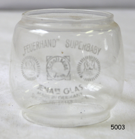
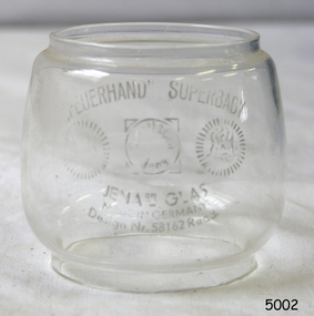
Functional object - Lantern Glass, Nier Feuerhand, 1933
... Flagstaff Hill Maritime Museum and Village 89 Merri Street Warrnambool great-ocean-road The Feuerhand lantern works were established in Beierfeld in the Saxon Ore Mountains. ...The Feuerhand lantern works were established in Beierfeld in the Saxon Ore Mountains. Called Erzgebirge in German or Krušné hory in Czech, is a mountain range in the south of Saxony in Germany known for its craftwork. Lantern production began in the area by Hermann Nier who ran a plumber's workshop around the 1870s and made lanterns, amongst other things. In the town of Beierfeld, also well-known for its metalworking were the brothers Hermann and Ernst Nier who founded a modern production centre for hurricane lanterns manufacture in 1893. Five years after the foundation, the company Frankonia (Albert Frank metalware) bought up the production site and the brothers Nier became production managers. Owing to differences with Frankonia, Hermann Nier finally started its hurricane lantern factory "Hermann Nier Feuerhandwerk" in 1902. In the same year, he applied for a patent for the manufacturing of lanterns using the stamping and folding techniques with tinning by hot-dipping and without hand-soldering. In 1914 the trademark "Feuerhand" was registered for all products as a utility model of the German Reich in German: "Deutsches Reichs-Gebrauchsmuster" (DRGM) and in 1920 the round Feuerhand emblem was added to the brand. Finally, in 1926 the patents, as well as the trademark "Firehand", were also registered in the USA. The manufacture of the well-known small hurricane lanterns the “Baby Series” complete with fireproof borosilicate glass from the Firma Schott firm from Jena started in 1933. Between 1918 and 1938 Nier Feuerhand became the biggest producer of hurricane lanterns in the world. Production continued until 1990.A significant item that demonstrates from its fabrication a manufacturing process that was far in advance of its time and that influenced the production of lanterns from many other manufactures around the world. These types of lanterns made by Feuerhand around the early 20th century are now sought after by collectors.Small round lantern replacement glass called "Feuerhand" Superbaby Model. Design No 58162.flagstaff hill, warrnambool, shipwrecked-coast, flagstaff-hill, flagstaff-hill-maritime-museum, maritime-museum, shipwreck-coast, flagstaff-hill-maritime-village, hurricane lamp glass replacement, glass, hurricane lamp, feuerhand lantern, jena glass works -
 Ringwood and District Historical Society
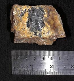
Geological specimen, Ringwood Antimony Mining samples
... Ringwood and District Historical Society 125A Warrandyte Road Ringwood North melbourne 4 pieces of stibnite, ore of antimony (Sb2S3) from Ringwood mines. ...4 pieces of stibnite, ore of antimony (Sb2S3) from Ringwood mines. Antimony sample. -
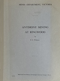 Ringwood and District Historical Society
Booklet - Mines Department, Victoria, Antimony Mining At Ringwood by H.E. Wilkinson, 1971
... Ringwood and District Historical Society 125A Warrandyte Road Ringwood North melbourne Between 1869 and 1892, the Ringwood antimony mines produced more than 3,500 tons of antimony ore, which represented bout 15 per cent of Victoria's antimony production for that period. ...Between 1869 and 1892, the Ringwood antimony mines produced more than 3,500 tons of antimony ore, which represented bout 15 per cent of Victoria's antimony production for that period. Much greater amounts were later taken from the mines at Costerfield and the Ringwood mines lapsed into obscurity. Most of the information in this booklet has been obtained from published and unpublished Geological Survey and Mines Department reports and Lease Records. (See full list of references included). -
Ringwood and District Historical Society
Geological specimen - Rock, Stibnite rock sample from a Ringwood antimony mine
... Ringwood and District Historical Society 125A Warrandyte Road Ringwood North melbourne Owned by Russ Haines since 1966. Antimony was mined in Ringwood during the 19th and early 20th centuries. The ore ...Owned by Russ Haines since 1966. Antimony was mined in Ringwood during the 19th and early 20th centuries. The ore known as Stibnite is a sulphide of Antimony. The metal is alloyed with lead in the manufacture of lead-acid batteries and in typesetting. Stibnite has been used for centuries as a cosmetic (marking eyebrows). The antimony ore may also contain gold.Lump of antimony rock (Stibnite) from the mine in Ringwood. See also History of Object. -
 Ringwood and District Historical Society
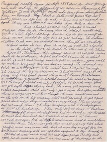
Document - Recollection, Story of William and James Smith - Ringwood from 1868 to 1920
... William and James Smith were credited for discovering antimony ore near the corner of Mt Dandenong Road and Maroondah Highway, with the main mine later developed by Pierce Boardman. ...Road Ringwood North melbourne Single page handwritten notes by unknown author (circa 1950) briefly outlining family history of William and James Smith in Ringwood from 1868 to 1920. Page ends mid-sentence however no trace of subsequent page/s. Further information on William and James Smith and family (expanding on these notes?), is contained in the book " A History of Croydon - Second Volume" by Muriel McGivern (pages 170-176). William and James Smith were credited for discovering antimony ore ...Single page handwritten notes by unknown author (circa 1950) briefly outlining family history of William and James Smith in Ringwood from 1868 to 1920. Page ends mid-sentence however no trace of subsequent page/s. Further information on William and James Smith and family (expanding on these notes?), is contained in the book " A History of Croydon - Second Volume" by Muriel McGivern (pages 170-176). William and James Smith were credited for discovering antimony ore near the corner of Mt Dandenong Road and Maroondah Highway, with the main mine later developed by Pierce Boardman. +Additional Keywords: Smith, William / Smith, James / Boardman / Pierce / Robason / antimony -
 Flagstaff Hill Maritime Museum and Village
Functional object - Lantern Glass, Nier Feuerhand, 1933
... Flagstaff Hill Maritime Museum and Village 89 Merri Street Warrnambool great-ocean-road The Feuerhand lantern works were established in Beierfeld in the Saxon Ore Mountains. ...The Feuerhand lantern works were established in Beierfeld in the Saxon Ore Mountains. Called Erzgebirge in German or Krušné hory in Czech, is a mountain range in the south of Saxony in Germany known for its craftwork. Lantern production began in the area by Hermann Nier who ran a plumber's workshop around the 1870s and made lanterns, amongst other things. In the town of Beierfeld, also well-known for its metalworking were the brothers Hermann and Ernst Nier who founded a modern production centre for hurricane lanterns manufacture in 1893. Five years after the foundation, the company Frankonia (Albert Frank metalware) bought up the production site and the brothers Nier became production managers. Owing to differences with Frankonia, Hermann Nier finally started its hurricane lantern factory "Hermann Nier Feuerhandwerk" in 1902. In the same year, he applied for a patent for the manufacturing of lanterns using the stamping and folding techniques with tinning by hot-dipping and without hand-soldering. In 1914 the trademark "Feuerhand" was registered for all products as a utility model of the German Reich in German: "Deutsches Reichs-Gebrauchsmuster" (DRGM) and in 1920 the round Feuerhand emblem was added to the brand. Finally, in 1926 the patents, as well as the trademark "Firehand", were also registered in the USA. The manufacture of the well-known small hurricane lanterns the “Baby Series” complete with fireproof borosilicate glass from the Firma Schott firm from Jena started in 1933. Between 1918 and 1938 Nier Feuerhand became the biggest producer of hurricane lanterns in the world. Production continued until 1990.A significant item that demonstrates from its fabrication a manufacturing process that was far in advance of its time and that influenced the production of lanterns from many other manufactures around the world. These types of lanterns made by Feuerhand around the early 20th century are now sought after by collectors.Small round lantern replacement glass called "Feuerhand" Superbaby Model. Design No 58162.flagstaff hill, warrnambool, shipwrecked-coast, flagstaff-hill, flagstaff-hill-maritime-museum, maritime-museum, shipwreck-coast, flagstaff-hill-maritime-village, hurricane lamp glass replacement, glass, hurricane lamp, feuerhand lantern, jena glass works -
 Flagstaff Hill Maritime Museum and Village
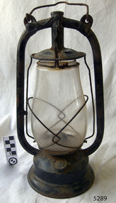
Functional object - Hurricane Lantern, Nier Feuerhand, Between 1915-1920
... Flagstaff Hill Maritime Museum and Village 89 Merri Street Warrnambool great-ocean-road The Feuerhand lantern works were established in Beierfeld in the Saxon Ore Mountains. ...The Feuerhand lantern works were established in Beierfeld in the Saxon Ore Mountains. Called Erzgebirge in German or Krušné hory in Czech, is a mountain range in the south of Saxony in Germany known for its craftwork. Lantern production began in the area by Hermann Nier who ran a plumber's workshop around the 1870s and made lanterns, amongst other things. In the town of Beierfeld, also well-known for its metalworking were the brothers Hermann and Ernst Nier who founded a modern production centre for hurricane lanterns manufacture in 1893. Five years after the foundation, the company Frankonia (Albert Frank metalware) bought up the production site and the brothers Nier became production managers. Owing to differences with Frankonia, Hermann Nier finally started its hurricane lantern factory "Hermann Nier Feuerhandwerk" in 1902. In the same year, he applied for a patent for the manufacturing of lanterns using the stamping and folding techniques with tinning by hot-dipping and without hand-soldering. In 1914 the trademark "Feuerhand" was registered for all products as a utility model of the German Reich in German: "Deutsches Reichs-Gebrauchsmuster" (DRGM) and in 1920 the round Feuerhand emblem was added to the brand. Finally, in 1926 the patents, as well as the trademark "Firehand", were also registered in the USA. The manufacture of the well-known small hurricane lanterns the “Baby Series” complete with fireproof borosilicate glass from the Firma Schott firm from Jena started in 1933. Between 1918 and 1938 Nier Feuerhand became the biggest producer of hurricane lanterns in the world. Production continued until 1990.A significant item that demonstrates from its fabrication a manufacturing process that was far in advance of its time and that influenced the production of lanterns from many other manufactures around the world. These types of lanterns made by Feuerhand around the early 20th century are now sought after by collectors.Monarch style Lantern painted black. Made in Germany has Freuerhand, manufactures logo on filler cap and top of lamp centre postflagstaff hill, warrnambool, flagstaff-hill-maritime-museum, maritime-museum, shipwreck-coast, flagstaff-hill-maritime-village, hurricane lantern, kerosene lamp, feuerhand lantern works, albert frank metalware, hermann and ernst nier