Showing 40 items matching "parish of port melbourne"
-
 Port Melbourne Historical & Preservation Society
Booklet - Carmelite Parish newsletter, "The Carmelite" 7 October 2018, 2018 - 2019
... ...parish of port melbourne...Port Melbourne Historical & Preservation Society Port Melbourne Town Hall 333 Bay Street Port Melbourne melbourne These items were collected by a PMHPS member during 2018-19 and they have been retained as a group of ephemera religion - roman catholic church (st josephs) parish of port melbourne Various ephemera of local interest showing changes in community. .01 The Carmelite Parish newsletter booklet dated 7 October 2018 "The Carmelite" 7 October 2018 Booklet Carmelite Parish newsletter ...These items were collected by a PMHPS member during 2018-19 and they have been retained as a group of ephemeraVarious ephemera of local interest showing changes in community. .01 The Carmelite Parish newsletter booklet dated 7 October 2018religion - roman catholic church (st josephs), parish of port melbourne -
 Eltham District Historical Society Inc
Photograph - Aerial Photograph, Landata, Eltham; Crown Allotment 15, Section 5, Parish of Nillumbik (Stokes Orchard Estate), Feb. 1979
... Eltham District Historical Society Inc 728 Main Rd Eltham melbourne Centred on present day Diosma Rd, Stokes Pl, Nyora Rd and Eucalyptus Rd Historic Aerial Imagery Source: Landata.vic.gov.au Aerial Photo Details: Project No :1716 Project : WESTERN PORT FORESHORES Run : 15 Frame : 91 Date : 02/1979 Film Type : B/W Camera : RC8 Flying Height : 5500 Scale : 10000 Film Number : 3286 GDA2020 : 37°42'47"S, 145°09'57"E MGA2020 : 338339, 5824447 (55) Melways : 22 C4 (ed. 42) A History of the Development of Crown Allotment 15, Section 5, Parish of Nillumbik – Stokes Orchard Crown Allotment 15, Section 5, Parish of Nillumbik (CA15) is a square allotment of 158 acres or approximately a quarter of a square mile. ...Centred on present day Diosma Rd, Stokes Pl, Nyora Rd and Eucalyptus Rd Historic Aerial Imagery Source: Landata.vic.gov.au Aerial Photo Details: Project No :1716 Project : WESTERN PORT FORESHORES Run : 15 Frame : 91 Date : 02/1979 Film Type : B/W Camera : RC8 Flying Height : 5500 Scale : 10000 Film Number : 3286 GDA2020 : 37°42'47"S, 145°09'57"E MGA2020 : 338339, 5824447 (55) Melways : 22 C4 (ed. 42) A History of the Development of Crown Allotment 15, Section 5, Parish of Nillumbik – Stokes Orchard Crown Allotment 15, Section 5, Parish of Nillumbik (CA15) is a square allotment of 158 acres or approximately a quarter of a square mile. It lies just beyond the eastern end of Pitt Street, south of Nyora Road to the northern end of Eucalyptus Road and extends east from Eucalyptus Road to Reynolds Road. The topography of CA15 is generally steep, sloping up to a hill near the centre of the land, the ridgeline passing through the properties along the southern side of Diosma Road. Eucalyptus Road is a straight north-south road with its northern end at the north west corner of CA15. Until the end of the 1970s this road was an un-named Government Road and was largely not open to traffic. With residential development in the 1970s the road was constructed, and the council allocated the name obviously in recognition of the predominant species of the local bushland. CA15 was purchased from the Crown by George D’Arley Boursiquot, a prominent Melbourne printer, on 28th October 1852. On November 23, 1922, former Member for Gippsland and Melbourne Real Estate Agent, Hubert Patrick Keogh purchased the allotment then sold it March 13, 1925, to local farmer, Robert David Taylor, a former Shire of Eltham Councillor (1911-1920) and Shire President (1919). Taylor had extensive land holdings stretching west towards Bible Street and Main Road. The Taylor home was situated at the top of the hill in Bible Street at present day 82 Bible Street. At the time of Taylor’s purchase in 1925, CA15 was subdivided into 48 lots that could be described as small rural properties or large residential lots. A typical lot size was one hectare or 2.5 acres. The subdivision created two roads, Nyora Road, and Diosma Road, each following an irregular alignment between Eucalyptus and Reynolds Roads. However, the lots were not sold off separately nor were the roads constructed. The land effectively remained as one parcel for many further years. Robert David Taylor died November 30, 1934, and probate was granted to his son of the same name, Robert David Taylor of Bible Street, Salesman and William McLelland Vance Taylor of 73 Emmeline Street, Northcote, Clerk, with the transfer of the land into their names on July 8, 1935. Frank Stokes worked as a qualified accountant at Kennons leather factory in Burnley, while living at 1 Thomas Street, Mitcham. He suffered from migraines and wanted to return to working the land (he had previously worked on farms and orchards since coming to Australia from England in 1926, both in WA and Vic.). He first travelled to the district by train in July 1942 to find land with the intention to establish an orchard. By chance he met Arthur Bird of Bird Orchard (bounded by Pitt Street, Eucalyptus Road, and Wattle Grove) and they got talking over their common interest. Arthur put Frank up for the night and pointed out the land, 158 acres- part of the Taylor Estate- £900, Crown Allotment 15, Section 5, Parish of Nillumbik (CA15) somewhat diagonally opposite Bird Orchard. Stokes applied through the Riverina Agency to purchase the land who in turn applied for permission from Canberra to sell as there was a new government regulation introduced during the Second World War banning land sales except for immediate production. Stokes obtained a loan on his Mitcham house of £600 @ 5% and paid £450 deposit with quarterly payments of £15 spread over 5 years. Stokes was assisted and advised by Arthur Bird who farmed the neighbouring orchard. In early 1943 Stokes took possession and would catch the train out to Eltham on Fridays after work and began building a hut on the corner of Nyora Road and the Government Road (Eucalyptus Road) for shelter and to lock up tools. He established an orchard on the central western part of the land through the centre of which ran a natural waterway (part of the present-day linear park) and was able to pay a neighbour (Hawkins) to help with clearing and fencing 25 acres, and with a horse and single furrowed plough, planted approximately 2,500 fruit trees - cherries, peaches, plums, almonds, pears, apricots and lemons as well as a few apples and oranges; a massive task. Aerial photographs from the 1940s through to the 1990s clearly show the orchard with most of the larger CA15 site remaining as natural bushland. A huge problem was hares and rabbits eating all the new buds off the tiny trees. As well as laying poison he painted the trees with a mixture of cow manure and lime, often working by moonlight. Procurement of wire and wire netting was difficult because of the war but after much effort he obtained a permit from the Agricultural Department for supplies in March 1944. In February 1945 Stokes applied for a permit to build a “packing shed” as no house building was allowed. It was to be 33 feet x 21 feet and cost £312. It was constructed mostly from second-hand materials, which were hard to obtain, especially iron for roofing. Stokes finished work at Kennons on October 31, 1945, and in March 1946 he sold the family home at Mitcham for £1,230 plus £170 for furniture. On May 15, 1946, title to the CA15 property was issued to Frank Howard Alfred Stokes, Orchardist and Gladys Ethel Stokes, Married Woman, both of Pitt Street, Eltham. The family of five then moved into the very unfinished “packing shed” at Eltham, which was a struggle to weatherproof. Eventually rooms were divided off and lined with hessian bags and whitewashed. Their income was firewood (cut and sold), selling rockery stones and cut Sweet Bursaria. (It was discovered during the 1940s that Sweet Bursaria contained the sunscreen compound Aesculin. The RAAF utilised this compound from Sweet Bursaria during WW2 for pilots and gunners.) The orchard’s first fruit sale was a half-case of Le Vanq peaches in December 1947 for the price of 8 shillings. In 1956 plans for house were drawn and Glen Iris bricks purchased (1956 Olympic Rings variant). The building of the house commenced in 1957 - 12 feet of original packing shed was removed – and was completed in 1959. Water was connected from newly built pressure storage on the property at the end of 1959 and the electricity connection for the first time at 3pm on April 29, 1960. The house remains to present day (somewhat modified) at 1 Nyora Road, home to Nyora Studio Gallery. On occasions, spare remnants of the 1956 bricks have been known to be unearthed in gardens on the estate as they were utilised by Frank Stokes to fill in rabbit holes. On May 26, 1950, a parcel of land was compulsorily acquired by the Melbourne and Metropolitan Board of Works on the hilltop to establish an easement for a high-level service reservoir to augment Eltham’s water supply. The project also included pipe tracks for the necessary water mains. The reservoir has now been superseded by higher level water tanks east of Reynolds Road and its former site is now a public reserve. On November 27, 1964, the State Electricity Commission served notice to compulsorily acquire a further parcel through the eastern part of the land for a major electricity transmission line that augmented supply from the La Trobe Valley to Melbourne. The easement was registered February 11, 1966. The easement was widened July 18, 1969 for a second transmission line to be constructed. In 1971 Melbourne Metropolitan Planning Scheme amendments adopted Nyora Road as the boundary between a residential zone to the north and a rural zone to the south. This determined the future development of the land. In the mid-1970s the Shire of Eltham divided the orchard into numerous rate-able parcel lots, the 48 lots having been established in 1925 and the subsequent rates assessment proved unsustainable for Stokes. He commenced selling lots outside the boundary of the orchard, north of Diosma and South of Nyora. However shortly later the land between Nyora and Diosma Roads and west of the electricity easement was sold and subdivided into residential lots, a housing development by Macquarie Builders and marketed as the Stokes Orchard Estate. New streets were created, and most were named after trees, although one, Stokes Place, commemorates the former owners. The development was undertaken in two stages; Stage 1 (1975) encompassing Scarlet Ash Court, Ironbark Close and Peppermint Grove bounded by Nyora and Eucalyptus roads and Stage 2 (1978) encompassing Stokes Place, Orchard Way, The Crest and The Lookout bound by Nyora and Diosma roads. The developer, Macquarie Builders went bankrupt shortly after the release of Stage 2 leaving many purchasers to fend for themselves and arrange for their own independent builders. There were also difficulties with sewerage for the land immediately south of Diosma Road and so the conventional residential lots were abandoned in favour of larger lots. The development of Orchard Way, The Crest and The Lookout did not proceed as planned and the proposed lots were incorporated into five-acre parcels instead. These included a low-density group housing development by the Graves family and the award winning Choong House (1983) with Gordon Ford developed garden immediately next door situated on the ridge of the hill nestled amongst the original bush, Eucalypt trees and Sweet Bursaria. In 1994, Nillumbik Shire Council applied Significant Environment and Significant Landscape overlays upon the properties on the south side of Diosma Road to ensure protection of this natural bush garden environment. With the arrival of the sewer along Diosma Road in the 1990s, most of these five-acre parcels have since been subdivided multiple times. The Choong house presently sits on a 2.7-acre property, which in 2022 Nillumbik Council nominated for Cultural Significance Heritage protection and is considered potentially significant at State level. The Stokes family were also associated with the Eltham Christian Church. In the 1970s this church had met in temporary premises in Eltham. Lots of the original 1925 subdivision remained south of Nyora Road and a number of these lots were utilized for the Eltham Christian School, which was established by the Eltham Christian Church in 1981. The school operated on this site until 2000. The premises are now used by The Vine Baptist Church. By the mid-1980s the whole of CA15 had been developed for residential and school purposes, except for the sections north of Diosma Road and between the transmission lines and Reynolds Road. Sewerage issues had been resolved for the section north of Diosma Road and in 1987 it was in the process of being subdivided into residential lots. The development coincided with the discovery of colonies of the rare and endangered Eltham Copper Butterfly on the site. This resulted in a community and political campaign to save the butterfly habitat. With the co-operation of the land developer the subdivision was altered to create two bushland reserves in the critical butterfly habitat areas. In the late 1980s the State Government was investigating options for establishing a metropolitan ring road link between Diamond Creek and Ringwood. The chosen route was adjacent to Reynolds Road and so this created a freeze on development of CA15 between Reynolds Road and the electricity easement. The ring road proposal was eventually abandoned, and this part of the land was subdivided into low density residential lots. Diosma Road has been discontinued at the electricity easement and the eastern part incorporated into View Mount Court with access from Reynolds Road. The whole of CA15 has now been developed for residential or associated purposes, ranging from conventional density to quite low density south of Nyora Road. Some remnants of the orchard remain, a few cherry trees on the Graves property and a lone apple tree in Stokes Place. The butterfly reserves comprise significant areas of remnant bushland. Linear reserves through the estate link with central Eltham via the Woodridge linear reserve and with Research along the electricity easement. CA15 as it exists today has a complicated history of rural use, Government acquisition, urban development, and community action. References: • “Stokes Orchard, an incomplete history”; Russell Yeoman with Doug Orford • Correspondence, Beryl Bradbury (nee Stokes) • Aerial Photographs, 1931-1991, Landata (landata.vic.gov.au) • Certificate of Title, Vol. 4930 Fol. 985900 • Plan Number LP 10859 aerial photo, diosma road, eltham copper butterfly, eucalyptus road, ironbark close, nyora road, peppermint grove, peter & elizabeth pidgeon collection, power transmission lines, reynolds road, scarlet ash court, stokes orchard estate, stokes place, woodridge estate, frank stokes -
 Eltham District Historical Society Inc
Photograph - Aerial Photograph, Landata, Eltham; Crown Allotment 15, Section 5, Parish of Nillumbik (Stokes Orchard Estate), Jan. 1984
... Eltham District Historical Society Inc 728 Main Rd Eltham melbourne Centred on present day Diosma Rd, Stokes Pl, Nyora Rd and Eucalyptus Rd Historic Aerial Imagery Source: Landata.vic.gov.au Aerial Photo Details: Project No :1716 Project : WESTERN PORT FORESHORES Run : 15 Frame : 70 Date : 01/1984 Film Type : B/W Camera : RC8 Flying Height : 5300 Scale : 10000 Film Number : 3833 GDA2020 : 37°42'38"S, 145°10'09"E MGA2020 : 338612, 5824719 (55) Melways : 22 D4 (ed. 42) A History of the Development of Crown Allotment 15, Section 5, Parish of Nillumbik – Stokes Orchard Crown Allotment 15, Section 5, Parish of Nillumbik (CA15) is a square allotment of 158 acres or approximately a quarter of a square mile. ...Centred on present day Diosma Rd, Stokes Pl, Nyora Rd and Eucalyptus Rd Historic Aerial Imagery Source: Landata.vic.gov.au Aerial Photo Details: Project No :1716 Project : WESTERN PORT FORESHORES Run : 15 Frame : 70 Date : 01/1984 Film Type : B/W Camera : RC8 Flying Height : 5300 Scale : 10000 Film Number : 3833 GDA2020 : 37°42'38"S, 145°10'09"E MGA2020 : 338612, 5824719 (55) Melways : 22 D4 (ed. 42) A History of the Development of Crown Allotment 15, Section 5, Parish of Nillumbik – Stokes Orchard Crown Allotment 15, Section 5, Parish of Nillumbik (CA15) is a square allotment of 158 acres or approximately a quarter of a square mile. It lies just beyond the eastern end of Pitt Street, south of Nyora Road to the northern end of Eucalyptus Road and extends east from Eucalyptus Road to Reynolds Road. The topography of CA15 is generally steep, sloping up to a hill near the centre of the land, the ridgeline passing through the properties along the southern side of Diosma Road. Eucalyptus Road is a straight north-south road with its northern end at the north west corner of CA15. Until the end of the 1970s this road was an un-named Government Road and was largely not open to traffic. With residential development in the 1970s the road was constructed, and the council allocated the name obviously in recognition of the predominant species of the local bushland. CA15 was purchased from the Crown by George D’Arley Boursiquot, a prominent Melbourne printer, on 28th October 1852. On November 23, 1922, former Member for Gippsland and Melbourne Real Estate Agent, Hubert Patrick Keogh purchased the allotment then sold it March 13, 1925, to local farmer, Robert David Taylor, a former Shire of Eltham Councillor (1911-1920) and Shire President (1919). Taylor had extensive land holdings stretching west towards Bible Street and Main Road. The Taylor home was situated at the top of the hill in Bible Street at present day 82 Bible Street. At the time of Taylor’s purchase in 1925, CA15 was subdivided into 48 lots that could be described as small rural properties or large residential lots. A typical lot size was one hectare or 2.5 acres. The subdivision created two roads, Nyora Road, and Diosma Road, each following an irregular alignment between Eucalyptus and Reynolds Roads. However, the lots were not sold off separately nor were the roads constructed. The land effectively remained as one parcel for many further years. Robert David Taylor died November 30, 1934, and probate was granted to his son of the same name, Robert David Taylor of Bible Street, Salesman and William McLelland Vance Taylor of 73 Emmeline Street, Northcote, Clerk, with the transfer of the land into their names on July 8, 1935. Frank Stokes worked as a qualified accountant at Kennons leather factory in Burnley, while living at 1 Thomas Street, Mitcham. He suffered from migraines and wanted to return to working the land (he had previously worked on farms and orchards since coming to Australia from England in 1926, both in WA and Vic.). He first travelled to the district by train in July 1942 to find land with the intention to establish an orchard. By chance he met Arthur Bird of Bird Orchard (bounded by Pitt Street, Eucalyptus Road, and Wattle Grove) and they got talking over their common interest. Arthur put Frank up for the night and pointed out the land, 158 acres- part of the Taylor Estate- £900, Crown Allotment 15, Section 5, Parish of Nillumbik (CA15) somewhat diagonally opposite Bird Orchard. Stokes applied through the Riverina Agency to purchase the land who in turn applied for permission from Canberra to sell as there was a new government regulation introduced during the Second World War banning land sales except for immediate production. Stokes obtained a loan on his Mitcham house of £600 @ 5% and paid £450 deposit with quarterly payments of £15 spread over 5 years. Stokes was assisted and advised by Arthur Bird who farmed the neighbouring orchard. In early 1943 Stokes took possession and would catch the train out to Eltham on Fridays after work and began building a hut on the corner of Nyora Road and the Government Road (Eucalyptus Road) for shelter and to lock up tools. He established an orchard on the central western part of the land through the centre of which ran a natural waterway (part of the present-day linear park) and was able to pay a neighbour (Hawkins) to help with clearing and fencing 25 acres, and with a horse and single furrowed plough, planted approximately 2,500 fruit trees - cherries, peaches, plums, almonds, pears, apricots and lemons as well as a few apples and oranges; a massive task. Aerial photographs from the 1940s through to the 1990s clearly show the orchard with most of the larger CA15 site remaining as natural bushland. A huge problem was hares and rabbits eating all the new buds off the tiny trees. As well as laying poison he painted the trees with a mixture of cow manure and lime, often working by moonlight. Procurement of wire and wire netting was difficult because of the war but after much effort he obtained a permit from the Agricultural Department for supplies in March 1944. In February 1945 Stokes applied for a permit to build a “packing shed” as no house building was allowed. It was to be 33 feet x 21 feet and cost £312. It was constructed mostly from second-hand materials, which were hard to obtain, especially iron for roofing. Stokes finished work at Kennons on October 31, 1945, and in March 1946 he sold the family home at Mitcham for £1,230 plus £170 for furniture. On May 15, 1946, title to the CA15 property was issued to Frank Howard Alfred Stokes, Orchardist and Gladys Ethel Stokes, Married Woman, both of Pitt Street, Eltham. The family of five then moved into the very unfinished “packing shed” at Eltham, which was a struggle to weatherproof. Eventually rooms were divided off and lined with hessian bags and whitewashed. Their income was firewood (cut and sold), selling rockery stones and cut Sweet Bursaria. (It was discovered during the 1940s that Sweet Bursaria contained the sunscreen compound Aesculin. The RAAF utilised this compound from Sweet Bursaria during WW2 for pilots and gunners.) The orchard’s first fruit sale was a half-case of Le Vanq peaches in December 1947 for the price of 8 shillings. In 1956 plans for house were drawn and Glen Iris bricks purchased (1956 Olympic Rings variant). The building of the house commenced in 1957 - 12 feet of original packing shed was removed – and was completed in 1959. Water was connected from newly built pressure storage on the property at the end of 1959 and the electricity connection for the first time at 3pm on April 29, 1960. The house remains to present day (somewhat modified) at 1 Nyora Road, home to Nyora Studio Gallery. On occasions, spare remnants of the 1956 bricks have been known to be unearthed in gardens on the estate as they were utilised by Frank Stokes to fill in rabbit holes. On May 26, 1950, a parcel of land was compulsorily acquired by the Melbourne and Metropolitan Board of Works on the hilltop to establish an easement for a high-level service reservoir to augment Eltham’s water supply. The project also included pipe tracks for the necessary water mains. The reservoir has now been superseded by higher level water tanks east of Reynolds Road and its former site is now a public reserve. On November 27, 1964, the State Electricity Commission served notice to compulsorily acquire a further parcel through the eastern part of the land for a major electricity transmission line that augmented supply from the La Trobe Valley to Melbourne. The easement was registered February 11, 1966. The easement was widened July 18, 1969 for a second transmission line to be constructed. In 1971 Melbourne Metropolitan Planning Scheme amendments adopted Nyora Road as the boundary between a residential zone to the north and a rural zone to the south. This determined the future development of the land. In the mid-1970s the Shire of Eltham divided the orchard into numerous rate-able parcel lots, the 48 lots having been established in 1925 and the subsequent rates assessment proved unsustainable for Stokes. He commenced selling lots outside the boundary of the orchard, north of Diosma and South of Nyora. However shortly later the land between Nyora and Diosma Roads and west of the electricity easement was sold and subdivided into residential lots, a housing development by Macquarie Builders and marketed as the Stokes Orchard Estate. New streets were created, and most were named after trees, although one, Stokes Place, commemorates the former owners. The development was undertaken in two stages; Stage 1 (1975) encompassing Scarlet Ash Court, Ironbark Close and Peppermint Grove bounded by Nyora and Eucalyptus roads and Stage 2 (1978) encompassing Stokes Place, Orchard Way, The Crest and The Lookout bound by Nyora and Diosma roads. The developer, Macquarie Builders went bankrupt shortly after the release of Stage 2 leaving many purchasers to fend for themselves and arrange for their own independent builders. There were also difficulties with sewerage for the land immediately south of Diosma Road and so the conventional residential lots were abandoned in favour of larger lots. The development of Orchard Way, The Crest and The Lookout did not proceed as planned and the proposed lots were incorporated into five-acre parcels instead. These included a low-density group housing development by the Graves family and the award winning Choong House (1983) with Gordon Ford developed garden immediately next door situated on the ridge of the hill nestled amongst the original bush, Eucalypt trees and Sweet Bursaria. In 1994, Nillumbik Shire Council applied Significant Environment and Significant Landscape overlays upon the properties on the south side of Diosma Road to ensure protection of this natural bush garden environment. With the arrival of the sewer along Diosma Road in the 1990s, most of these five-acre parcels have since been subdivided multiple times. The Choong house presently sits on a 2.7-acre property, which in 2022 Nillumbik Council nominated for Cultural Significance Heritage protection and is considered potentially significant at State level. The Stokes family were also associated with the Eltham Christian Church. In the 1970s this church had met in temporary premises in Eltham. Lots of the original 1925 subdivision remained south of Nyora Road and a number of these lots were utilized for the Eltham Christian School, which was established by the Eltham Christian Church in 1981. The school operated on this site until 2000. The premises are now used by The Vine Baptist Church. By the mid-1980s the whole of CA15 had been developed for residential and school purposes, except for the sections north of Diosma Road and between the transmission lines and Reynolds Road. Sewerage issues had been resolved for the section north of Diosma Road and in 1987 it was in the process of being subdivided into residential lots. The development coincided with the discovery of colonies of the rare and endangered Eltham Copper Butterfly on the site. This resulted in a community and political campaign to save the butterfly habitat. With the co-operation of the land developer the subdivision was altered to create two bushland reserves in the critical butterfly habitat areas. In the late 1980s the State Government was investigating options for establishing a metropolitan ring road link between Diamond Creek and Ringwood. The chosen route was adjacent to Reynolds Road and so this created a freeze on development of CA15 between Reynolds Road and the electricity easement. The ring road proposal was eventually abandoned, and this part of the land was subdivided into low density residential lots. Diosma Road has been discontinued at the electricity easement and the eastern part incorporated into View Mount Court with access from Reynolds Road. The whole of CA15 has now been developed for residential or associated purposes, ranging from conventional density to quite low density south of Nyora Road. Some remnants of the orchard remain, a few cherry trees on the Graves property and a lone apple tree in Stokes Place. The butterfly reserves comprise significant areas of remnant bushland. Linear reserves through the estate link with central Eltham via the Woodridge linear reserve and with Research along the electricity easement. CA15 as it exists today has a complicated history of rural use, Government acquisition, urban development, and community action. References: • “Stokes Orchard, an incomplete history”; Russell Yeoman with Doug Orford • Correspondence, Beryl Bradbury (nee Stokes) • Aerial Photographs, 1931-1991, Landata (landata.vic.gov.au) • Certificate of Title, Vol. 4930 Fol. 985900 • Plan Number LP 10859 aerial photo, diosma road, eltham copper butterfly, eucalyptus road, ironbark close, nyora road, peppermint grove, peter & elizabeth pidgeon collection, power transmission lines, reynolds road, scarlet ash court, stokes orchard estate, stokes place, woodridge estate, frank stokes -
 Eltham District Historical Society Inc
Photograph - Aerial Photograph, Landata, Eltham; Crown Allotment 15, Section 5, Parish of Nillumbik (Stokes Orchard Estate), Mar. 1987
... Eltham District Historical Society Inc 728 Main Rd Eltham melbourne Centred on present day Diosma Rd, Stokes Pl, Nyora Rd and Eucalyptus Rd Historic Aerial Imagery Source: Landata.vic.gov.au Aerial Photo Details: Project No :1716 Project : WESTERN PORT FORESHORES Run : 15 Frame : 108 Date : 03/1987 Film Type : B/W Camera : RC10 Flying Height : 5600 Scale : 10000 Film Number : 4102 GDA2020 : 37°43'00"S, 145°10'13"E MGA2020 : 338725, 5824036 (55) Melways : 22 D5 (ed. 42)719 (55) Melways : 22 D4 (ed. 42) A History of the Development of Crown Allotment 15, Section 5, Parish of Nillumbik – Stokes Orchard Crown Allotment 15, Section 5, Parish of Nillumbik (CA15) is a square allotment of 158 acres or approximately a quarter of a square mile. ...Centred on present day Diosma Rd, Stokes Pl, Nyora Rd and Eucalyptus Rd Historic Aerial Imagery Source: Landata.vic.gov.au Aerial Photo Details: Project No :1716 Project : WESTERN PORT FORESHORES Run : 15 Frame : 108 Date : 03/1987 Film Type : B/W Camera : RC10 Flying Height : 5600 Scale : 10000 Film Number : 4102 GDA2020 : 37°43'00"S, 145°10'13"E MGA2020 : 338725, 5824036 (55) Melways : 22 D5 (ed. 42)719 (55) Melways : 22 D4 (ed. 42) A History of the Development of Crown Allotment 15, Section 5, Parish of Nillumbik – Stokes Orchard Crown Allotment 15, Section 5, Parish of Nillumbik (CA15) is a square allotment of 158 acres or approximately a quarter of a square mile. It lies just beyond the eastern end of Pitt Street, south of Nyora Road to the northern end of Eucalyptus Road and extends east from Eucalyptus Road to Reynolds Road. The topography of CA15 is generally steep, sloping up to a hill near the centre of the land, the ridgeline passing through the properties along the southern side of Diosma Road. Eucalyptus Road is a straight north-south road with its northern end at the north west corner of CA15. Until the end of the 1970s this road was an un-named Government Road and was largely not open to traffic. With residential development in the 1970s the road was constructed, and the council allocated the name obviously in recognition of the predominant species of the local bushland. CA15 was purchased from the Crown by George D’Arley Boursiquot, a prominent Melbourne printer, on 28th October 1852. On November 23, 1922, former Member for Gippsland and Melbourne Real Estate Agent, Hubert Patrick Keogh purchased the allotment then sold it March 13, 1925, to local farmer, Robert David Taylor, a former Shire of Eltham Councillor (1911-1920) and Shire President (1919). Taylor had extensive land holdings stretching west towards Bible Street and Main Road. The Taylor home was situated at the top of the hill in Bible Street at present day 82 Bible Street. At the time of Taylor’s purchase in 1925, CA15 was subdivided into 48 lots that could be described as small rural properties or large residential lots. A typical lot size was one hectare or 2.5 acres. The subdivision created two roads, Nyora Road, and Diosma Road, each following an irregular alignment between Eucalyptus and Reynolds Roads. However, the lots were not sold off separately nor were the roads constructed. The land effectively remained as one parcel for many further years. Robert David Taylor died November 30, 1934, and probate was granted to his son of the same name, Robert David Taylor of Bible Street, Salesman and William McLelland Vance Taylor of 73 Emmeline Street, Northcote, Clerk, with the transfer of the land into their names on July 8, 1935. Frank Stokes worked as a qualified accountant at Kennons leather factory in Burnley, while living at 1 Thomas Street, Mitcham. He suffered from migraines and wanted to return to working the land (he had previously worked on farms and orchards since coming to Australia from England in 1926, both in WA and Vic.). He first travelled to the district by train in July 1942 to find land with the intention to establish an orchard. By chance he met Arthur Bird of Bird Orchard (bounded by Pitt Street, Eucalyptus Road, and Wattle Grove) and they got talking over their common interest. Arthur put Frank up for the night and pointed out the land, 158 acres- part of the Taylor Estate- £900, Crown Allotment 15, Section 5, Parish of Nillumbik (CA15) somewhat diagonally opposite Bird Orchard. Stokes applied through the Riverina Agency to purchase the land who in turn applied for permission from Canberra to sell as there was a new government regulation introduced during the Second World War banning land sales except for immediate production. Stokes obtained a loan on his Mitcham house of £600 @ 5% and paid £450 deposit with quarterly payments of £15 spread over 5 years. Stokes was assisted and advised by Arthur Bird who farmed the neighbouring orchard. In early 1943 Stokes took possession and would catch the train out to Eltham on Fridays after work and began building a hut on the corner of Nyora Road and the Government Road (Eucalyptus Road) for shelter and to lock up tools. He established an orchard on the central western part of the land through the centre of which ran a natural waterway (part of the present-day linear park) and was able to pay a neighbour (Hawkins) to help with clearing and fencing 25 acres, and with a horse and single furrowed plough, planted approximately 2,500 fruit trees - cherries, peaches, plums, almonds, pears, apricots and lemons as well as a few apples and oranges; a massive task. Aerial photographs from the 1940s through to the 1990s clearly show the orchard with most of the larger CA15 site remaining as natural bushland. A huge problem was hares and rabbits eating all the new buds off the tiny trees. As well as laying poison he painted the trees with a mixture of cow manure and lime, often working by moonlight. Procurement of wire and wire netting was difficult because of the war but after much effort he obtained a permit from the Agricultural Department for supplies in March 1944. In February 1945 Stokes applied for a permit to build a “packing shed” as no house building was allowed. It was to be 33 feet x 21 feet and cost £312. It was constructed mostly from second-hand materials, which were hard to obtain, especially iron for roofing. Stokes finished work at Kennons on October 31, 1945, and in March 1946 he sold the family home at Mitcham for £1,230 plus £170 for furniture. On May 15, 1946, title to the CA15 property was issued to Frank Howard Alfred Stokes, Orchardist and Gladys Ethel Stokes, Married Woman, both of Pitt Street, Eltham. The family of five then moved into the very unfinished “packing shed” at Eltham, which was a struggle to weatherproof. Eventually rooms were divided off and lined with hessian bags and whitewashed. Their income was firewood (cut and sold), selling rockery stones and cut Sweet Bursaria. (It was discovered during the 1940s that Sweet Bursaria contained the sunscreen compound Aesculin. The RAAF utilised this compound from Sweet Bursaria during WW2 for pilots and gunners.) The orchard’s first fruit sale was a half-case of Le Vanq peaches in December 1947 for the price of 8 shillings. In 1956 plans for house were drawn and Glen Iris bricks purchased (1956 Olympic Rings variant). The building of the house commenced in 1957 - 12 feet of original packing shed was removed – and was completed in 1959. Water was connected from newly built pressure storage on the property at the end of 1959 and the electricity connection for the first time at 3pm on April 29, 1960. The house remains to present day (somewhat modified) at 1 Nyora Road, home to Nyora Studio Gallery. On occasions, spare remnants of the 1956 bricks have been known to be unearthed in gardens on the estate as they were utilised by Frank Stokes to fill in rabbit holes. On May 26, 1950, a parcel of land was compulsorily acquired by the Melbourne and Metropolitan Board of Works on the hilltop to establish an easement for a high-level service reservoir to augment Eltham’s water supply. The project also included pipe tracks for the necessary water mains. The reservoir has now been superseded by higher level water tanks east of Reynolds Road and its former site is now a public reserve. On November 27, 1964, the State Electricity Commission served notice to compulsorily acquire a further parcel through the eastern part of the land for a major electricity transmission line that augmented supply from the La Trobe Valley to Melbourne. The easement was registered February 11, 1966. The easement was widened July 18, 1969 for a second transmission line to be constructed. In 1971 Melbourne Metropolitan Planning Scheme amendments adopted Nyora Road as the boundary between a residential zone to the north and a rural zone to the south. This determined the future development of the land. In the mid-1970s the Shire of Eltham divided the orchard into numerous rate-able parcel lots, the 48 lots having been established in 1925 and the subsequent rates assessment proved unsustainable for Stokes. He commenced selling lots outside the boundary of the orchard, north of Diosma and South of Nyora. However shortly later the land between Nyora and Diosma Roads and west of the electricity easement was sold and subdivided into residential lots, a housing development by Macquarie Builders and marketed as the Stokes Orchard Estate. New streets were created, and most were named after trees, although one, Stokes Place, commemorates the former owners. The development was undertaken in two stages; Stage 1 (1975) encompassing Scarlet Ash Court, Ironbark Close and Peppermint Grove bounded by Nyora and Eucalyptus roads and Stage 2 (1978) encompassing Stokes Place, Orchard Way, The Crest and The Lookout bound by Nyora and Diosma roads. The developer, Macquarie Builders went bankrupt shortly after the release of Stage 2 leaving many purchasers to fend for themselves and arrange for their own independent builders. There were also difficulties with sewerage for the land immediately south of Diosma Road and so the conventional residential lots were abandoned in favour of larger lots. The development of Orchard Way, The Crest and The Lookout did not proceed as planned and the proposed lots were incorporated into five-acre parcels instead. These included a low-density group housing development by the Graves family and the award winning Choong House (1983) with Gordon Ford developed garden immediately next door situated on the ridge of the hill nestled amongst the original bush, Eucalypt trees and Sweet Bursaria. In 1994, Nillumbik Shire Council applied Significant Environment and Significant Landscape overlays upon the properties on the south side of Diosma Road to ensure protection of this natural bush garden environment. With the arrival of the sewer along Diosma Road in the 1990s, most of these five-acre parcels have since been subdivided multiple times. The Choong house presently sits on a 2.7-acre property, which in 2022 Nillumbik Council nominated for Cultural Significance Heritage protection and is considered potentially significant at State level. The Stokes family were also associated with the Eltham Christian Church. In the 1970s this church had met in temporary premises in Eltham. Lots of the original 1925 subdivision remained south of Nyora Road and a number of these lots were utilized for the Eltham Christian School, which was established by the Eltham Christian Church in 1981. The school operated on this site until 2000. The premises are now used by The Vine Baptist Church. By the mid-1980s the whole of CA15 had been developed for residential and school purposes, except for the sections north of Diosma Road and between the transmission lines and Reynolds Road. Sewerage issues had been resolved for the section north of Diosma Road and in 1987 it was in the process of being subdivided into residential lots. The development coincided with the discovery of colonies of the rare and endangered Eltham Copper Butterfly on the site. This resulted in a community and political campaign to save the butterfly habitat. With the co-operation of the land developer the subdivision was altered to create two bushland reserves in the critical butterfly habitat areas. In the late 1980s the State Government was investigating options for establishing a metropolitan ring road link between Diamond Creek and Ringwood. The chosen route was adjacent to Reynolds Road and so this created a freeze on development of CA15 between Reynolds Road and the electricity easement. The ring road proposal was eventually abandoned, and this part of the land was subdivided into low density residential lots. Diosma Road has been discontinued at the electricity easement and the eastern part incorporated into View Mount Court with access from Reynolds Road. The whole of CA15 has now been developed for residential or associated purposes, ranging from conventional density to quite low density south of Nyora Road. Some remnants of the orchard remain, a few cherry trees on the Graves property and a lone apple tree in Stokes Place. The butterfly reserves comprise significant areas of remnant bushland. Linear reserves through the estate link with central Eltham via the Woodridge linear reserve and with Research along the electricity easement. CA15 as it exists today has a complicated history of rural use, Government acquisition, urban development, and community action. References: • “Stokes Orchard, an incomplete history”; Russell Yeoman with Doug Orford • Correspondence, Beryl Bradbury (nee Stokes) • Aerial Photographs, 1931-1991, Landata (landata.vic.gov.au) • Certificate of Title, Vol. 4930 Fol. 985900 • Plan Number LP 10859 aerial photo, diosma road, eltham copper butterfly, eucalyptus road, ironbark close, nyora road, peppermint grove, peter & elizabeth pidgeon collection, power transmission lines, reynolds road, scarlet ash court, stokes orchard estate, stokes place, woodridge estate, frank stokes -
Eltham District Historical Society Inc
Document - Folder, Sweeney
... melbourne Thomas Sweeney (1802-1867) was transported in 1823 and granted a conditional pardon in 1838. He married and moved to the Port Phillip District, buying land at Eltham. His house, "Culla Hill" (renamed "Sweeneys") still stands. Contents Typed notes, no author, no date, biography of Thomas Sweeney with copy of parish ...Thomas Sweeney (1802-1867) was transported in 1823 and granted a conditional pardon in 1838. He married and moved to the Port Phillip District, buying land at Eltham. His house, "Culla Hill" (renamed "Sweeneys") still stands. Contents Typed notes, no author, no date, biography of Thomas Sweeney with copy of parish plan showing Sweeney's original and later land purchases. Typed timeline Thomas Sweeney and typed transcriptions of letters to and from La Trobe archives to Thomas Sweeney. Handwritten notes: Biography of Thomas Sweeney and his descendants, also transcription of letter 10 April 1849 wanting a bridge over the Plenty River, and transcription of C J La Trobe's reply. Photocopy magazine article: "Sweeneys: A home with a hisitory", Australian Home Beautiful, 1 February 1940. Story of Thomas Sweeney and his house, with photographs. Newspaper article: "Capt. Sweeney, Eltham's first Irish settler", Associated Newspapers Eltham Cenenary Supplement, 30 March 1971. Notes on Thomas Sweeney and his house. Photocopy of p.30, "Diamond Valley Sketchbook", Brian McKinlay, 1973. "Sweeney's Cottage, Eltham. Notes and drawing of Sweeneys. Newspaper article: "A convict's cottage", Diamond Valley News, 6 October 1981. Notes on Thomas Sweeney and his house. Newspaper article: "Talented cartoonist depicts story of an Eltham pioneer", Diamond Valley News, 18 February 1986. Judith Russell had drawn cartoons of Thomas Sweeney's life called "Sweeney". Prospectus "Historic Sweeneys Culla Hill, Auction 27 Noveber 1993, 3.00 pm": Photographs and history of property, with map of lots and vegetation.. Newspaper article: "A pioneer's cottage, new-age apartments and a leafy city retreat", The Age Real Estate, 21 June 1997. Photograph and details of "Sweeneys" Newspaper article: "Legacy of convict's success", Diamond Valley News, 2 July 1997. Notes on Thomas Sweeney and his house (for sale), photograph of John Sweeney and family. Printout, National Trust register: Sweeney's. History and description of Sweeneys. Letter Mary Nelson to Eltham District Historical Society, 14 October 2004, enclosing photocopies of material on "Culla Hill" and Mary Sweeney and Michael Carrucan.Newspaper clippings, A4 photocopies, etcthomas sweeney, mary sweeney, patrick sweeney, ship isabella, mary sweeney nee meehan, "culla hill" eltham, "sweeneys" eltham, sweeneys lane eltham, michael connors, patrick guyder, george brown of illawarra district, margaret sweeney nee meehan, paddy sweeney, john sweeney, kate sweene, margaret sweeney, ellen sweeney, annie sweeney], johanna sweeney, annie sweeney, caroline sweeney, mary carrucan nee sweeney, agatha sweeney, agnes sweeney, arthur sweeney, cassie sweeney, frank sweeney, victor burston, peter cuffley, jim murray, bridget sweeney nee coleman, graham caulfield, mccorlick real estate eltham, mary nelson, betty erickson nee carrucan, michael carrucan -
 Eltham District Historical Society Inc
Photograph - Digital Photograph, Alan King, Sweeney's Cottage, Sweeneys Lane, Eltham, 30 January 2008
... They then moved to Port Phillip and squatted on the south side of the Yarra River, about seven miles (11km) from Melbourne. Around 1842, Sweeney bought 110 acres (44.5ha) in the parish of Nillumbik for £110. ...They then moved to Port Phillip and squatted on the south side of the Yarra River, about seven miles (11km) from Melbourne. Around 1842, Sweeney bought 110 acres (44.5ha) in the parish of Nillumbik for £110. ...Part of the original cottage named Culla Hill built by Thomas Sweeney (a former convict) remains as a small section of today’s house. Covered under Heritage Overlay, Nillumbik Planning Scheme National Estate National Trust of Australia (Victoria) Local Sifgnificance Published: Nillumbik Now and Then / Marguerite Marshall 2008; photographs Alan King with Marguerite Marshall.; p19 Thomas Sweeney, a former convict who became a respected citizen, once lived on a property at what is now the corner of Sweeneys Lane and Culla Hill, Eltham. As Sweeney was one of the district’s first settlers, the property is registered by the National Trust. Thomas Sweeney was born in 1802, son of impoverished tenant farmers in Tipperary County, Ireland. He became a ploughman, then at 21 he was sentenced to hang for setting on fire the house of Patrick Guyder at Gullshill. It is said the arson was due to a dispute over undelivered guns to a social justice guerilla group, the White Boys, of which Sweeney was a member. But the sentence was commuted to life transportation to Australia in 1823.1 Apparently in Sydney he became a servant to James Chandler at Botany. Soon James Chandler leased his farm and became a catechist on the Hawkesbury River, so Sweeney was reassigned to a former convict, John Brown, at Liverpool. Later Sweeney was assigned to George Brown of Lake Illawarra. In 1831, Sweeney was granted a ticket-of-leave and bought a boat to carry goods between Illawarra district and Sydney Town. He married his first wife who had come to Australia as a free woman. However she drowned after bearing him a daughter. In 1838, one month after he had received a conditional pardon, Sweeney married a blacksmith’s daughter, Margaret Meehan, newly arrived from Ireland. They then moved to Port Phillip and squatted on the south side of the Yarra River, about seven miles (11km) from Melbourne. Around 1842, Sweeney bought 110 acres (44.5ha) in the parish of Nillumbik for £110. He built a slab hut 12 x 10 feet (3.6m x 3m) and then his homestead, Culla Hill, a typical Tipperary style cottage, now known as Sweeney’s Cottage. It was here that many generations of Sweeneys lived for almost 100 years. Culla Hill became a social centre for the district and the Catholic community used it as a church. Sweeney was apparently on good terms with a tribe of Aborigines living on the river nearby, who helped him build his house.2 Sweeney proved himself a civic-minded leader. In 1844, he led a call for a bridge over the Plenty River. He was on the first school board and supplied the first grain for Eltham’s mill. Sweeney profited during the gold rush, not by gold digging, but by providing supplies for nearby fields and others as far away as Beechworth.3 Thomas Sweeney died in 1867 and was buried at the Eltham Cemetery, leaving two sons, five daughters, and 300 acres (121.4ha), as well as Culla Hill. Culla Hill – by then reduced to 75 acres (30ha) – was sold out of the family in 1939, then renamed Sweeneys. The present Sweeneys Lane, running diagonally through the original holding, was the track to the house. Part of the original cottage remains as a small section of today’s house. The dining-family room fronted by a veranda is original, and although there have been some changes, the cedar door and most of the small 12-paned wooden-framed windows are original. The walls are made of the original hand-made brick. After buying the property in 1952 Mr and Mrs Burston demolished a dilapidated slab hut, a three-roomed detached kitchen and cellar, as materials needed to restore them were very difficult to obtain so soon after the war.4 However the barn remains almost in its original condition. It is believed to have been built from stone quarried on the property. Now roofed with iron sheets it was probably originally thatched. The sandstone barn has a peaked roof supported by the original saplings and a doorway large enough to accommodate a fully loaded wagon.This collection of almost 130 photos about places and people within the Shire of Nillumbik, an urban and rural municipality in Melbourne's north, contributes to an understanding of the history of the Shire. Published in 2008 immediately prior to the Black Saturday bushfires of February 7, 2009, it documents sites that were impacted, and in some cases destroyed by the fires. It includes photographs taken especially for the publication, creating a unique time capsule representing the Shire in the early 21st century. It remains the most recent comprehenesive publication devoted to the Shire's history connecting local residents to the past. nillumbik now and then (marshall-king) collection, culla hill, eltham, sweeney's cottage, sweeneys lane, thomas sweeney -
Glen Eira Historical Society
Article - Holy Cross Church, Glen Huntly Road, 705, Caulfield South
... melbourne Two Holy Cross Musical Society Programs. Undated. Patience or Bunthorne’s Bride and The Mikado Article from Caulfield/ Port Phillip Leader 09/08/2011 Parish to Share Load Colour photo with article. ...Two Holy Cross Musical Society Programs. Undated. Patience or Bunthorne’s Bride and The Mikado Article from Caulfield/ Port Phillip Leader 09/08/2011 Parish to Share Load Colour photo with article.holy cross church, freese christina, caulfield south, glen huntly road, rosenberger virginia, catholic church, programs, mckenny ross fr., holy cross advisory committee, southwick david mp lane colin -
Glen Eira Historical Society
Article - St Peter's Catholic Church, Bentleigh East
... Melbourne South... Bignell Road... Kennedy Market Garden... Oakleigh... St Peter's Parish... St James Parish... The Living Harvest... Catholic Church... Hibernian Society... Bavarian Brass Band... St Peter's Primary School... St James Regional College... Brighton Catholic School... Brighton – St Kilda Mission... Niall Patrick William FR... Dendy Henry... Guiney John MR... King Richard... King John... Keys George... O’ Shanassy John... Keys Robert... Were Jonathan B.... O’ Connell John FR... Glass Hugh MR... O’ Farrell Peter... Brady Peter... Kennedy James... Boland Michael... McCormick Francis... Orrong Road... Little Brighton... Oakleigh... Port...Elsternwick North Road Quinn Fred Bentleigh Centre Road Kennedy James Joseph Melbourne South Bignell Road Kennedy Market Garden Oakleigh St Peter's Parish St James Parish The Living Harvest Catholic Church Hibernian Society Bavarian Brass Band St Peter's Primary School St James Regional College Brighton Catholic School Brighton – St Kilda Mission Niall Patrick William FR Dendy Henry Guiney John MR King Richard King John Keys George O’ Shanassy John Keys Robert Were Jonathan B. O’ Connell John FR Glass Hugh MR O’ Farrell Peter Brady Peter Kennedy James Boland Michael McCormick Francis Orrong Road Little Brighton Oakleigh Port ...Included In The File is A Newspaper Clipping From The Age Newspaper, Dated Sat 09/11/1974 On The Opening Written By Stuart Sayers. The Article Mentions A Brief History Of The Church & School Beginnings & The Opening Ceremony. There Are Two Copies Of The Living Harvest (One Without The Cover), The Book Gives A Detailed History Of St Peter's Catholic Church, Bentleigh East Written By W.T. Dobson And Published in 1974. From The First White Settlers, The Irish Exodus, And The Irish Catholic families, The School House And The History Of The Parish & Clergy Up To 1974.st peter's catholic church, niall patrick rev, emerald hill, bentleigh east, dobson w. t., yarra, moorabbin, heriot m. b., elsternwick, north road, quinn fred, bentleigh, centre road, kennedy james joseph, melbourne south, bignell road, kennedy market garden, oakleigh, st peter's parish, st james parish, the living harvest, catholic church, hibernian society, bavarian brass band, st peter's primary school, st james regional college, brighton catholic school, brighton – st kilda mission, niall patrick william fr, dendy henry, guiney john mr, king richard, king john, keys george, o’ shanassy john, keys robert, were jonathan b., o’ connell john fr, glass hugh mr, o’ farrell peter, brady peter, kennedy james, boland michael, mccormick francis, orrong road, little brighton, oakleigh, port phillip bay, east boundary road, north road, ormond, old dandenong road, mordialloc creek, moorabbin, springvale, no good damper road, kingstown, keysborough, bignell road, south road, heatherton, big brighton, gardenvale, elsternwick, brady road, jasper road, chesterville road, cochrane road, mcguinness road, h.a.c.b.s., school house, st patrick's church, brighton parish, denominational school, little brighton school, moorabbin catholic school, temporary chapel, st james regional college, sister of mercy, lanigans ball, east brighton public hall company ltd, east bentleigh hall, messrs. robert dunn & son, bavarian brass band, st joan of arc parish, east bentleigh parish, the sisters of our lady of sacred heart, the anchor club, mccormick cornelius, cochrane james, cochrane david, mcguinness margaret, cormick john, cahill james, quinn frederick, prendegast john patrick, naughton dennis, leary william, charlston john, carey matthew fr, gibbons patrick, kennedy joseph james, o’ sullivan tim fr, mckenna fred fr, casey william fr, browne joseph fr, crawford mal fr, hanrahan mr, gillon rose miss, sampson kate mrs, horan miss, coakley daniel fr, dillon kevin fr, whitehouse ray fr, mannix daniel dr, dobson william mr, gahan patrick, hallinan thomas, delaney john, fitzgerald patrick, st peter's catholic church -
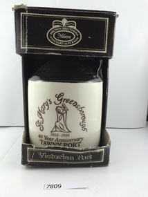 Greensborough Historical Society
Container - Bottle, St Mary's Greensborough 40 year anniversary tawny port, 1995
... Greensborough Historical Society 34A Glenauburn Road Lower Plenty Lower Plenty melbourne Commemorative Port issued in 1995 to celebrate the 40th anniversary of the opening of St Mary's Church in Greensborough. st marys parish greensborough st marys catholic church greensborough brown brothers Brown Brothers Milawa Vineyard Australia: Viictorian Port on cardboard container Ceramic wine bottle with cork in cardboard container, black and white St Mary's Greensborough 40 year anniversary tawny port Container Bottle ...Commemorative Port issued in 1995 to celebrate the 40th anniversary of the opening of St Mary's Church in Greensborough.Ceramic wine bottle with cork in cardboard container, black and whiteBrown Brothers Milawa Vineyard Australia: Viictorian Port on cardboard containerst marys parish greensborough, st marys catholic church greensborough, brown brothers -
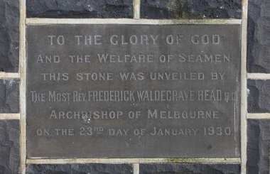 Mission to Seafarers Victoria
Photograph - Digital photograph
... Port Melbourne was in need of renovation. In February 1929 a fundraising was organised by the Box Hill branch of the Ladies Harbour Lights Guild: "The Mayoress of Box Hill (Mrs. C. Palling) opened a very successful Australian tea, held on Tuesday afternoon in St. Peter's Parish...Port Melbourne was in need of renovation. In February 1929 a fundraising was organised by the Box Hill branch of the Ladies Harbour Lights Guild: "The Mayoress of Box Hill (Mrs. C. Palling) opened a very successful Australian tea, held on Tuesday afternoon in St. Peter's Parish ...Built in 1888, the building at Port Melbourne was in need of renovation. In February 1929 a fundraising was organised by the Box Hill branch of the Ladies Harbour Lights Guild: "The Mayoress of Box Hill (Mrs. C. Palling) opened a very successful Australian tea, held on Tuesday afternoon in St. Peter's Parish Hall, by members of the Box Hill branch of the Ladies' Harbour Lights Guild, to raise funds towards the cost of renovating the Port Melbourne Seamen's institute. The building is in a very dilapidated condition, and is totally inadequate for the extensive requirements of the Mission to Seamen." (1929 'AUSTRALIAN TEA.', Box Hill Reporter (Vic. : 1925 - 1930), 15 February, p. 7.) "Additional buildings at the Seamen's Institute, conducted by the Victoria Missions to Seamen, at Port Melbourne, were officially opened and dedicated yesterday (23 January 1930) by Archbishop Head. The additions, which have been erected at a cost of £3000, comprise an extension of the recreation hall, new canteen and office, ladies' rest room, apprentices' room, officers' room, and five-roomed dwelling, for the caretaker." 1930 'MISSION TO SEAMEN.', The Age (Melbourne, Vic. : 1854 - 1954), 24 January, p. 13.Rectangular foundation stone with inscription inlayed in a bluestone wall.To the glory of God and the welfare of seamen/ This stone was unveiled by the most Rev. Frederick Waldegrave Head B.O. Archbishop of Melbourne, on the 23rd day of January 1930archbishop head, port melbourne, reverend h. s. bailey, building renovations, 1930, port melbourne mission -
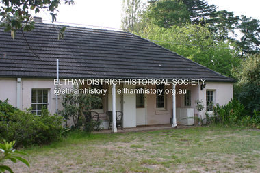
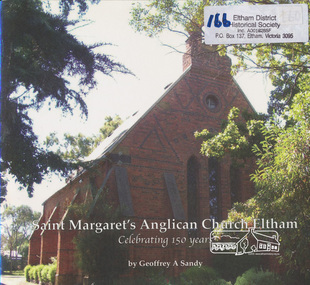 Eltham District Historical Society Inc
Book, Geoffrey A Sandy, Saint Margaret's Anglican Church Eltham by Geoffrey A Sandy, 2011
... Eltham District Historical Society Inc 728 Main Rd Eltham melbourne History of first 150 years of St Margaret's Anglican Parish Eltham st margaret's anglican parish ISBN 9780646562674 [signed by author on inside front cover and dated 17/11/11] 24 p. : ill. (some col.), ports ...History of first 150 years of St Margaret's Anglican Parish Eltham24 p. : ill. (some col.), ports. ; 21 x 23 cm.ISBN 9780646562674 [signed by author on inside front cover and dated 17/11/11]st margaret's anglican parish -
Port Melbourne Historical & Preservation Society
Map - Port Melbourne, Department of Lands and Survey, 20 Sep 1932
... Dept. of Lands and Survey Map Sheet 5 Port Melbourne, Parish of South Melbourne....Port Melbourne Historical & Preservation Society Port Melbourne Town Hall 333 Bay Street Port Melbourne melbourne Town Planning Sandridge Lagoon Melbourne Harbor Trust - Port of Melbourne Authority Transport - Railways Annotated re MHT precincts on foreshore:Plan sketches re boat harbour Dept. of Lands and Survey Map Sheet 5 Port Melbourne, Parish of South Melbourne. ...Dept. of Lands and Survey Map Sheet 5 Port Melbourne, Parish of South Melbourne.Annotated re MHT precincts on foreshore:Plan sketches re boat harbourtown planning, sandridge lagoon, melbourne harbor trust - port of melbourne authority, transport - railways -
Port Melbourne Historical & Preservation Society
Plan - Port Melbourne, 1882
... Large, deteriorated 1882 plan of Port Melbourne, Parish of South Melbourne, County of Bourke - showing Town Lots. ...Port Melbourne Historical & Preservation Society Port Melbourne Town Hall 333 Bay Street Port Melbourne melbourne Town Planning Fishermans Bend Sandridge Lagoon Transport - Railways Large, deteriorated 1882 plan of Port Melbourne, Parish of South Melbourne, County of Bourke - showing Town Lots. ...Large, deteriorated 1882 plan of Port Melbourne, Parish of South Melbourne, County of Bourke - showing Town Lots. Pasted onto board.town planning, fishermans bend, sandridge lagoon, transport - railways -
Port Melbourne Historical & Preservation Society
Photograph - First communion, St Joseph's, Port Melbourne, 1951 - 1952
... Port Melbourne Historical & Preservation Society Port Melbourne Town Hall 333 Bay Street Port Melbourne melbourne Education - Primary Schools Bernard O'FARREL Niel KING Vin ELDER TOM MOLONEY Kevin ROBERTS Trevor SHORT Terry LITTLE Chris POWER Roy KENT Frank O'CONNOR John REYNOLDS Some names on back First communion photo. St Josephs 1951 or 1952. Parish ...First communion photo. St Josephs 1951 or 1952. Parish Priest Father Bernard O'FARREL. Taken in school yard corner Bay and Rouse Streets against Swallows ice cream company wall.Some names on backeducation - primary schools, bernard o'farrel, niel king, vin elder, tom moloney, kevin roberts, trevor short, terry little, chris power, roy kent, frank o'connor, john reynolds -
Port Melbourne Historical & Preservation Society
Document - Invitation, Consecretion of Holy Trinity Anglican Church, Port Melbourne, Nov 2017
... Port Melbourne Historical & Preservation Society Port Melbourne Town Hall 333 Bay Street Port Melbourne melbourne The new church has been consecrated within the original Parish Hall, after the church itself was sold for redevelopment celebrations fetes and exhibitions religion - anglican (holy trinity) rev noel whale rev dr philip frier Invitation to attend the consecration of Holy Trinity Anglican Church of Port Melbourne by the Archbishop of Melbourne, Dr Philip Frier, Sunday 12 Nov 2017 Document Invitation, Consecretion of Holy Trinity Anglican Church, Port Melbourne ...The new church has been consecrated within the original Parish Hall, after the church itself was sold for redevelopmentInvitation to attend the consecration of Holy Trinity Anglican Church of Port Melbourne by the Archbishop of Melbourne, Dr Philip Frier, Sunday 12 Nov 2017celebrations fetes and exhibitions, religion - anglican (holy trinity), rev noel whale, rev dr philip frier -
Port Melbourne Historical & Preservation Society
Map, City of Port Melbourne. Parishes of melbourne South. Doutta Galla, c. 1930
... City of Port Melbourne. Parishes of Melbourne South. Doutta Galla Copy of map circa 1930, showing Port Melbourne, Station and Town piers. ...Port Melbourne Historical & Preservation Society Port Melbourne Town Hall 333 Bay Street Port Melbourne melbourne built environment engineering department - city of port melbourne City of Port Melbourne. Parishes ...City of Port Melbourne. Parishes of Melbourne South. Doutta Galla Copy of map circa 1930, showing Port Melbourne, Station and Town piers. Map is black on white paper with numbered red dots on most residential blocks. 1876 written in ballpoint on bottom - possibly date of first edition, before later additions.built environment, engineering department - city of port melbourne -
 Port Melbourne Historical & Preservation Society
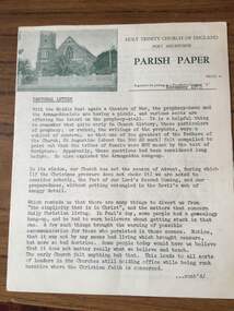
Document - Newsletter, Holy Trinity Anglican Church, Port Melbourne, Parish Paper, Nov 1973
... Port Melbourne Holy Trinity Church. Details information about the month of August 1974 for the Church and communicates information to parish goers...Monthly parish newsletter for the month of November 1973 for Holy Trinity Church, Port Melbourne...Port Melbourne Historical & Preservation Society Port Melbourne Town Hall 333 Bay Street Port Melbourne melbourne Newsletter was written for Port Melbourne Holy Trinity Church. Details information about the month of August 1974 for the Church and communicates information to parish goers Religion - Anglican (Holy Trinity) Deaths and Funerals Donald Arthur LANGFORD Lewis J MULLIN Archibald H CARMICHAEL Glynn E G MARSHALL Phillip LAWSON William A WOODS Elsie J BAXTER Eliza M AANENSEN Ernest J McCOLL William H KILPATRICK Allan A CALLICK Emily NEWTON-SIMPSON Georgia Anita FENNESSY Robert Michael FLAHERTY Raymond Bede GRZONEK Christine Carol BATH Leanne ALDERMAN Returned Services League RSL Sandridge Trugo Club South Melbourne Football Club Albert Park Bowling Club Henry MOLLOY Ged MUSTON W H COFFEY George VINES Mrs MUSTON P BEDFORD C TUNCKS John MOORE Port Melbourne Bowling Club Port Melbourne Football Club Port Melbourne Cricket Club F McGORLICK Mrs McGORLICK Lions Club W STUCKBURY J T McLEOD D JONES G CECIL Yvonne Margaret KITCHEN F A W 'Skip' SHORT Monthly parish newsletter for the month of November 1973 for Holy Trinity Church, Port Melbourne Parish Paper Document Newsletter, Holy Trinity Anglican Church, Port Melbourne ...Newsletter was written for Port Melbourne Holy Trinity Church. Details information about the month of August 1974 for the Church and communicates information to parish goersMonthly parish newsletter for the month of November 1973 for Holy Trinity Church, Port Melbournereligion - anglican (holy trinity), deaths and funerals, donald arthur langford, lewis j mullin, archibald h carmichael, glynn e g marshall, phillip lawson, william a woods, elsie j baxter, eliza m aanensen, ernest j mccoll, william h kilpatrick, allan a callick, emily newton-simpson, georgia anita fennessy, robert michael flaherty, raymond bede grzonek, christine carol bath, leanne alderman, returned services league, rsl, sandridge trugo club, south melbourne football club, albert park bowling club, henry molloy, ged muston, w h coffey, george vines, mrs muston, p bedford, c tuncks, john moore, port melbourne bowling club, port melbourne football club, port melbourne cricket club, f mcgorlick, mrs mcgorlick, lions club, w stuckbury, j t mcleod, d jones, g cecil, yvonne margaret kitchen, f a w 'skip' short -
Port Melbourne Historical & Preservation Society
Photograph - Garden City Pensioner's Club at Warburton, 16 Oct 1963
... Port Melbourne Historical & Preservation Society Port Melbourne Town Hall 333 Bay Street Port Melbourne melbourne garden city garden city pensioner's club st mary's warburton Garden .01 - B&W photocopy of Garden City Pensioner's Club at Warburton (16.10.1963). .02 B&W photocopy of Garden City Pensioner's Club outside St Mary's Parish Hall at Warburton (16.10.1963). ....01 - B&W photocopy of Garden City Pensioner's Club at Warburton (16.10.1963). .02 B&W photocopy of Garden City Pensioner's Club outside St Mary's Parish Hall at Warburton (16.10.1963).Gardengarden city, garden city pensioner's club, st mary's warburton -
Port Melbourne Historical & Preservation Society
Book - Novello's Parish Choir book
... Port Melbourne Historical & Preservation Society Port Melbourne Town Hall 333 Bay Street Port Melbourne melbourne religion - anglican (holy trinity) Novello's Parish Choir book. ...Novello's Parish Choir book. Office of the Holy Communion. Insert: Six chantsreligion - anglican (holy trinity) -
Port Melbourne Historical & Preservation Society
Document - Newsletter, Parish Papers, Holy Trinity Anglican Church, Port Melbourne, 1971 - 1974
... Newsletter, Parish Papers, Holy Trinity Anglican Church, Port Melbourne...Six issues of the Parish Papers of Holy Trinity Church of England, Port Melbourne: 1971 - 1974. ...Port Melbourne Historical & Preservation Society Port Melbourne Town Hall 333 Bay Street Port Melbourne melbourne Religion - Anglican (Holy Trinity) P A LONGFORD Mrs P HARJES Shirley LAWSON Harriet HALL Alice Ruth SIDWELL Mrs L TURNER Six issues of the Parish Papers of Holy Trinity Church of England, Port Melbourne: 1971 - 1974. ...Six issues of the Parish Papers of Holy Trinity Church of England, Port Melbourne: 1971 - 1974. Photo of the church at upper left corner, showing picket fence and Bay Street entrance. religion - anglican (holy trinity), p a longford, mrs p harjes, shirley lawson, harriet hall, alice ruth sidwell, mrs l turner -
Port Melbourne Historical & Preservation Society
Book, Ian Breward, South Port Parks Parish Mission: 150 Years of Service, 2003
... Port Melbourne Historical & Preservation Society Port Melbourne Town Hall 333 Bay Street Port Melbourne melbourne This was written by PMH&PS member Ian BREWARD, who is the archivist for the Uniting Church in Melbourne, and therefore for the Methodist, Congregational and Presbyterian churches. It was launched at the Uniting Church in South Melbourne on 2003. Religion - Uniting Church Religion - Wesleyan Methodist Church Religion - Primitive Methodist Church Religion - Presbyterian Church Ian BREWARD Emily LOCK Hazel WILSON Nancy U'REN nee MORRIS South Port Parks Parish ...This was written by PMH&PS member Ian BREWARD, who is the archivist for the Uniting Church in Melbourne, and therefore for the Methodist, Congregational and Presbyterian churches. It was launched at the Uniting Church in South Melbourne on 2003.South Port Parks Parish Mission: 150 Years of Service by Ian BREWARD - A history of the congregations and missions. Soft cover, 174 pp, illustrated.religion - uniting church, religion - wesleyan methodist church, religion - primitive methodist church, religion - presbyterian church, ian breward, emily lock, hazel wilson, nancy u'ren nee morris -
Port Melbourne Historical & Preservation Society
Programme, St Joseph's Parish - Reopening of the Church, Sep 1999
... Port Melbourne Historical & Preservation Society Port Melbourne Town Hall 333 Bay Street Port Melbourne melbourne Church and grounds were renovated in 1999, completed 4th September in time for the reopening service the following day. Hugh BROWN, Parish ...Church and grounds were renovated in 1999, completed 4th September in time for the reopening service the following day. Hugh BROWN, Parish PriestProgram of service for the reopening of St Joseph's Catholic Church 5 Sept 1999. 16pp, cover cream and green with full colour representation of stained glass windowreligion - roman catholic church (st josephs), celebrations fetes and exhibitions, jim power, hugh brown, fred elliott, kay elliott, robert winduss, dianne drury, bill blackmore, jacqui o'callaghan, cellia carmody, joseph lynch, sally o'shannessy, norma sheehan, charlotte winduss, frances moore, paula elliot, ed mcdonnell, fiona mcdonnell, scott mcdonnell, brendan o'donnell, kate ryan, kate cleaves -
Port Melbourne Historical & Preservation Society
Document - Bulletin, St Joseph's Parish - Reopening of the Church, Sep 1999
... Port Melbourne Historical & Preservation Society Port Melbourne Town Hall 333 Bay Street Port Melbourne melbourne Church and grounds were renovated in 1999, completed 4th September in time for the reopening service the following days. Hugh BROWN, Parish ...Church and grounds were renovated in 1999, completed 4th September in time for the reopening service the following days. Hugh BROWN, Parish PriestChurch bulletin for the reopening of St Joseph's Catholic Church 5 Sept 1999. 4pp, light green insert in programreligion - roman catholic church (st josephs), celebrations fetes and exhibitions, jim power, hugh brown, fred elliott, kay elliott, robert winduss, dianne drury, bill blackmore, jacqui o'callaghan, cellia carmody, joseph lynch, sally o'shannessy, norma sheehan, charlotte winduss, frances moore, paula elliot, ed mcdonnell, fiona mcdonnell, scott mcdonnell, brendan o'donnell, kate ryan, kate cleaves -
Port Melbourne Historical & Preservation Society
Archive - Port 'n' South Living and Learning Centre, Jul 1990
... Port Melbourne Historical & Preservation Society Port Melbourne Town Hall 333 Bay Street Port Melbourne melbourne The centre was one of several community groups established in the mid 1980's. After 1998 when the Baptist Church decided to discontinue the relationship, co-ordinator Julie Allen donated the minutes, brochures, photos and other records to the society. education community education - adult societies clubs unions and other organisations religion - baptist church julie allen alec babos christine fensham jenni evans south port parks parish mission From archive box containing the archives of the Port 'n' South Living and Learning Centre located at the Ross St Baptist church, 1985 to 1998. ...The centre was one of several community groups established in the mid 1980's. After 1998 when the Baptist Church decided to discontinue the relationship, co-ordinator Julie Allen donated the minutes, brochures, photos and other records to the society.From archive box containing the archives of the Port 'n' South Living and Learning Centre located at the Ross St Baptist church, 1985 to 1998. Also includes item 1207 (various files listed on separate attachment) Refer also to items 1084 and 819. .18 Report on jobs, South Port Parks Parish Mission Program result May to June 1990, 27pp; light blue 2with ultramarine tape bindingeducation, community, education - adult, societies clubs unions and other organisations, religion - baptist church, julie allen, alec babos, christine fensham, jenni evans, south port parks parish mission -
 Port Melbourne Historical & Preservation Society
Photograph - St Joseph's Catholic Primary School, Premiers, Peanut Farm Reserve, St Kilda, 1960s
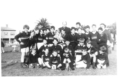
... Port Melbourne Historical & Preservation Society Port Melbourne Town Hall 333 Bay Street Port Melbourne melbourne Phyl NICHOLLS Education - Primary Schools Sport - Australian Rules Football St Josephs Catholic Primary School Religion - Roman Catholic Church (St Josephs) B&W photo St Josephs Catholic Primary Premiers 1967, taken at the Peanut Farm Reserve in St Kilda. The parish ...B&W photo St Josephs Catholic Primary Premiers 1967, taken at the Peanut Farm Reserve in St Kilda. The parish priest is at centre back, coach Phyl NICHOLLS at back right.phyl nicholls, education - primary schools, sport - australian rules football, st josephs catholic primary school, religion - roman catholic church (st josephs) -
Port Melbourne Historical & Preservation Society
Map - Footscray, Public Lands Office, 19 Oct 1857
... Port Melbourne Historical & Preservation Society Port Melbourne Town Hall 333 Bay Street Port Melbourne melbourne footscray The Township of Footscray, Parish of Cut-Paw-Paw Map of Footscray, west of Saltwater Creek; south of Hopkins Street, east of Railway and north southern boundary of Botanical Garden reserve. ...Map of Footscray, west of Saltwater Creek; south of Hopkins Street, east of Railway and north southern boundary of Botanical Garden reserve.The Township of Footscray, Parish of Cut-Paw-Pawfootscray -
Port Melbourne Historical & Preservation Society
Plan - Photographic copy, Plan of allotments marked at Sandridge, 1849, Lindsay Clarke, Surveyor, c. 1849
... Port Melbourne Historical & Preservation Society Port Melbourne Town Hall 333 Bay Street Port Melbourne melbourne Town Planning Business and Traders - Hotels Lindsay CLARKE Wilbraham Frederick Evelyn LIARDET WFE LIARDET On back, '7' in ink Photographic copy of 'Plan of allotments marked at Sandridge in the Parish of South Melbourne; by surveyor Lindsay Clarke 1849 Plan Photographic copy, Plan of allotments marked at Sandridge, 1849 Lindsay Clarke, Surveyor ...Photographic copy of 'Plan of allotments marked at Sandridge in the Parish of South Melbourne; by surveyor Lindsay Clarke 1849On back, '7' in inktown planning, business and traders - hotels, lindsay clarke, wilbraham frederick evelyn liardet, wfe liardet -
 City of Moorabbin Historical Society (Operating the Box Cottage Museum)
Newsletter, City of Moorabbin Historical Society Feb 2009, February 2009
... melbourne...moorabbin...brighton...cheltenham...ormond...bentleigh...vineyards...fruit growing...vine diseases...winemaking...grapes...market gardeners...pioneers...early settlers...moorabbin shire...box cottage museum...dairy...port phillip bay...brighton estate...moor henry...cambden estate...reitman j....reitman w....cement...pottery...jasper road ormond...east boundary road brighton...dendy’s special survey 1851...point nepean road...south road brighton...thomas street brighton...north road brighton...county of bourke...box h....box william...bruton william...brighton brewery...parish...Tom Sheehy, past President of CMHS, was an Historian and Author of ‘Battlers Tamed the Sandbelt’. city of moorabbin historical society stanley helen sheehy tom melbourne moorabbin brighton cheltenham ormond bentleigh vineyards fruit growing vine diseases winemaking grapes market gardeners pioneers early settlers moorabbin shire box cottage museum dairy port phillip bay brighton estate moor henry cambden estate reitman j. reitman w. cement pottery jasper road ormond east boundary road brighton dendy’s special survey 1851 point nepean road south road brighton thomas street brighton north road brighton county of bourke box h. box william bruton william brighton brewery parish of moorabbin parish of prahran markets shingle roof weather-board downward mr. mckinnon CITY of MOORABBIN HISTORICAL SOCIETY / FEBRUARY 2009 NEWSLETTER 2 x A4 paper printed on 3 sides Issue 10 of the bi-monthly, City of Moorabbin Historical Society Newsletter produced by Society member and Secretary, Mrs Helen Stanley in February 2009. ...The City of Moorabbin Historical Society was formed c 1960 by a group of Moorabbin residents who were concerned that the history of the area should be preserved. A good response to a call for items related to the historical area of Moorabbin Shire brought donations of a wide variety of artefacts which are now preserved by the current members of CMHS at Box Cottage Museum . Helen Stanley, Secretary of CMHS, began producing a Newsletter for members in April 2007 to provide current information and well researched items of historical interest.Helen Stanley has produced a bi-monthly Newsletter, 2007 - 2013, for the members of the City of Moorabbin Historical Society that contains well researched interesting historical items, notification of upcoming events, current advice from Royal Australian Historical Society , Museums Australia Victoria and activities of Local Historical Societies. The Newsletter is an important record of the activities of the CMHS. Tom Sheehy, past President of CMHS, was an Historian and Author of ‘Battlers Tamed the Sandbelt’. 2 x A4 paper printed on 3 sides Issue 10 of the bi-monthly, City of Moorabbin Historical Society Newsletter produced by Society member and Secretary, Mrs Helen Stanley in February 2009. The Victorian Bushfire tragedy around Marysville is still unfolding as this Newsletter is written. The first meeting for the year is February 22nd and subscriptions are due. An excerpt is transcribed from the City of Moorabbin Historical Society Newsletter October 1962, “A Piece of History in Ormond” by an unknown eyewitness author, describing the original “Box Cottage” situated in Mr J. Reitman’s cement products factory at 306 Jasper Road, Ormond prior to demolition. The current Editor gives information obtained from further recent research . An Article by Tom Sheehy, past President and Historian, February 1979 “The Vineyards of Moorabbin”. The ‘Brighton Estate” began when Henry Moor brought Vine cuttings from Camden NSW 1848 and they were productive after 3 years. Many Vineyards then appeared from Port Phillip Bay to East Boundary Road and produced 2/3 of the annual Victorian grape crop. Disease or insect caused failure in1858 and the land reverted to market gardens. A coloured photocopied photo of Box Cottage 2005. CITY of MOORABBIN HISTORICAL SOCIETY / FEBRUARY 2009 NEWSLETTERcity of moorabbin historical society, stanley helen, sheehy tom, melbourne, moorabbin, brighton, cheltenham, ormond, bentleigh, vineyards, fruit growing, vine diseases, winemaking, grapes, market gardeners, pioneers, early settlers, moorabbin shire, box cottage museum, dairy, port phillip bay, brighton estate, moor henry, cambden estate, reitman j., reitman w., cement, pottery, jasper road ormond, east boundary road brighton, dendy’s special survey 1851, point nepean road, south road brighton, thomas street brighton, north road brighton, county of bourke, box h., box william, bruton william, brighton brewery, parish of moorabbin, parish of prahran, markets, shingle roof, weather-board, downward mr., mckinnon -
 City of Moorabbin Historical Society (Operating the Box Cottage Museum)
Newsletter, City of Moorabbin Historical Society Apr 2009, April 2009
... melbourne...moorabbin...brighton...friends of cheltenham and reional cemeteries...cheltenham...ormond...bentleigh...market gardeners...irish immigrants c1850pioneers...early settlers...moorabbin shire...box cottage museum...port phillip bay...brighton estate...jasper road ormond...east boundary road brighton...dendy’s special survey 1851...point nepean road...south road brighton...thomas street brighton...north road brighton...county of bourke...box h....box william...parish...The Newsletter is an important record of the activities of the CMHS. city of moorabbin historical society stanley helen dobson w.t. melbourne moorabbin brighton friends of cheltenham and reional cemeteries cheltenham ormond bentleigh market gardeners irish immigrants c1850pioneers early settlers moorabbin shire box cottage museum port phillip bay brighton estate jasper road ormond east boundary road brighton dendy’s special survey 1851 point nepean road south road brighton thomas street brighton north road brighton county of bourke box h. box william parish of moorabbin parish of prahran markets shingle roof weather-board mr. mckinnon were jonathan niall rev. fr. patrick quinn fred elsternwick catholic church directory 1878 hibernian society melbourne brady peter. kennedy mr. boland mr. leary mr. gahan mr. archbishop carr rev. fr. gough. presentation convent gardenvale sister mary vincent charlston john bavarian dress band hales jasper CITY of MOORABBIN HISTORICAL SOCIETY / APRIL 2009 NEWSLETTER 2 x A4 paper printed on 4 sides Issue 11 of the bi-monthly, City of Moorabbin Historical Society Newsletter produced by Society member and Secretary, Mrs Helen Stanley in April 2009. ...The City of Moorabbin Historical Society was formed c 1960 by a group of Moorabbin residents who were concerned that the history of the area should be preserved. A good response to a call for items related to the historical area of Moorabbin Shire brought donations of a wide variety of artefacts which are now preserved by the current members of CMHS at Box Cottage Museum . Helen Stanley, Secretary of CMHS, began producing a Newsletter for members in April 2007 to provide current information and well researched items of historical interest.Helen Stanley has produced a bi-monthly Newsletter, 2007 - 2013, for the members of the City of Moorabbin Historical Society that contains well researched interesting historical items, notification of upcoming events, current advice from Royal Australian Historical Society , Museums Australia Victoria and activities of Local Historical Societies. The Newsletter is an important record of the activities of the CMHS.2 x A4 paper printed on 4 sides Issue 11 of the bi-monthly, City of Moorabbin Historical Society Newsletter produced by Society member and Secretary, Mrs Helen Stanley in April 2009. Notice that Mr Travis Sellars, Friends of Cheltenham and Regional Cemeteries, will talk about ‘The Tragic 20’s’ at the meeting April 26th . Volunteers are needed to show visitors around on Open Days each month and a Roster will be made on April 26th . Suggestions are requested for the Community Grant Application to be submitted by CMHS. Historical details are condensed from ‘ The Living Harvest’ by W.T Dobson, describing the establishment of St. Peter’s Catholic School East Bentleigh 1865 on land donated by Fred Quinn , in Centre Road, East Brighton ( East Bentleigh). A photo copy of Parts of Country Portion 39 of Dendy’s Special Survey or Brighton Estate showing the Land Sales of Lot 2, & 3 North Road and Jasper Road 1841 – 1869. Interesting note on the origin of ‘Jasper Road’. 3 photocopied photographs of St Peter’s School building 1903, School Children at East Brighton Railway Station, 1903, A Lorry in the parade 1903. CITY of MOORABBIN HISTORICAL SOCIETY / APRIL 2009 NEWSLETTERcity of moorabbin historical society, stanley helen, dobson w.t., melbourne, moorabbin, brighton, friends of cheltenham and reional cemeteries, cheltenham, ormond, bentleigh, market gardeners, irish immigrants c1850pioneers, early settlers, moorabbin shire, box cottage museum, port phillip bay, brighton estate, jasper road ormond, east boundary road brighton, dendy’s special survey 1851, point nepean road, south road brighton, thomas street brighton, north road brighton, county of bourke, box h., box william, parish of moorabbin, parish of prahran, markets, shingle roof, weather-board, mr., mckinnon, were jonathan, niall rev. fr. patrick, quinn fred, elsternwick, catholic church directory 1878, hibernian society melbourne, brady peter., kennedy mr., boland mr., leary mr., gahan mr., archbishop carr, rev. fr. gough., presentation convent gardenvale, sister mary vincent, charlston john, bavarian dress band, hales jasper -
 City of Moorabbin Historical Society (Operating the Box Cottage Museum)
Newsletter, City of Moorabbin Historical Society June 2009, June 2009
... melbourne...moorabbin...brighton...cheltenham...ormond...bentleigh...market gardeners...pioneers...early settlers...moorabbin shire...box cottage museum...jasper road ormond...dendy’s special survey 1851...north road brighton...county of bourke...box h....box william...parish of moorabbin...were jonathan...hales jasper...port...Jasper Hale , transported for theft, earned his ‘Ticket of Leave, and purchased land in Dendy’s Special Survey of 1841 later known as East Bentleigh. city of moorabbin historical society stanley helen rigby jan melbourne moorabbin brighton cheltenham ormond bentleigh market gardeners pioneers early settlers moorabbin shire box cottage museum jasper road ormond dendy’s special survey 1851 north road brighton county of bourke box h. box william parish of moorabbin were jonathan hales jasper port jackson penal colony burgess s. william kemble wiltshire england stonemason bricklayer ‘york’ sailing ship brummell mary st. mary’s catholic church sydney nelson mary ann ‘george hibbert’ sailing ship hale james hale eliza parkes new south wales gold rush ballarat gold rush clunes gold rush forbes nsw gold rush parkes historical society CITY of MOORABBIN HISTORICAL SOCIETY / JUNE 2009 NEWSLETTER 2 x A4 paper printed on 3 sides Issue 12 of the bi-monthly, City of Moorabbin Historical Society Newsletter produced by Society member and Secretary, Mrs Helen Stanley in June 2009. ...The City of Moorabbin Historical Society was formed c 1960 by a group of Moorabbin residents who were concerned that the history of the area should be preserved. A good response to a call for items related to the historical area of Moorabbin Shire brought donations of a wide variety of artefacts which are now preserved by the current members of CMHS at Box Cottage Museum . Helen Stanley, Secretary of CMHS, began producing a Newsletter for members in April 2007 to provide current information and well researched items of historical interest.Helen Stanley has produced a bi-monthly Newsletter, 2007 - 2013, for the members of the City of Moorabbin Historical Society that contains well researched interesting historical items, notification of upcoming events, current advice from Royal Australian Historical Society , Museums Australia Victoria and activities of Local Historical Societies. The Newsletter is an important record of the activities of the CMHS. Jasper Hale , transported for theft, earned his ‘Ticket of Leave, and purchased land in Dendy’s Special Survey of 1841 later known as East Bentleigh. 2 x A4 paper printed on 3 sides Issue 12 of the bi-monthly, City of Moorabbin Historical Society Newsletter produced by Society member and Secretary, Mrs Helen Stanley in June 2009. Notices of the meeting June 28th , an article in ‘The Leader’ newspaper about the Robert Keys ‘Best Fruit Garden 1881 - 82’ Trophy Cup , a large vinyl banner purchased with Grant money, and while acknowledging the Cottage garden volunteer a request for more helpers at Open Days is made. Jan Rigby, CMHS member, has provided research information about Jasper Hale b 1805 in Gloucester, England, transported to NSW 1830, ‘freed man ‘ 1839, purchased land in Dendy’s Special Survey 1844, sold this land 1846 and died 1884 in Parkes NSW. On arrival as a convict in 1830 his occupation is bricklayer and he can ‘ read and write’. CITY of MOORABBIN HISTORICAL SOCIETY / JUNE 2009 NEWSLETTERcity of moorabbin historical society, stanley helen, rigby jan, melbourne, moorabbin, brighton, cheltenham, ormond, bentleigh, market gardeners, pioneers, early settlers, moorabbin shire, box cottage museum, jasper road ormond, dendy’s special survey 1851, north road brighton, county of bourke, box h., box william, parish of moorabbin, were jonathan, hales jasper, port jackson penal colony, burgess s. william, kemble wiltshire england, stonemason, bricklayer, ‘york’ sailing ship, brummell mary, st. mary’s catholic church sydney, nelson mary ann, ‘george hibbert’ sailing ship, hale james, hale eliza, parkes new south wales gold rush, ballarat gold rush, clunes gold rush, forbes nsw gold rush, parkes historical society