Showing 562 items matching "park street (kew)"
-
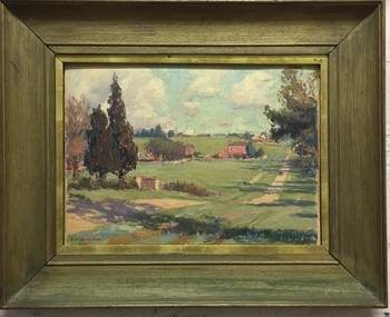
![Painting: Park Street [Adeney Avenue] Kew](/media/collectors/550653872162f11fb04854aa/items/5826877cd0cdd11284ad5413/item-media/614ac683a53a0756fd5e49da/item-fit-380x285.jpg?cb=6) Kew Historical Society Inc
Kew Historical Society IncPainting, Park Street [Adeney Avenue] Kew, c. 1896
... Park Street [Adeney Avenue] Kew......park street (kew)...‘Adeney Avenue’ was the title given to this painting following its donation to the Kew Historical Society, yet the work’s origins predate the naming of Adeney Avenue in 1907 [originally gazetted as ‘Park Street’ (1865) and ‘Park Street South’ (1875).] ...The painting is historically significant as it records the cleared and farmed landscape by settlers in the Nineteenth century. adeney avenue (kew) eborensis park street (kew) Label on rear of frame states "House on corner of Adeney Ave & Parkhill. ...‘Adeney Avenue’ was the title given to this painting following its donation to the Kew Historical Society, yet the work’s origins predate the naming of Adeney Avenue in 1907 [originally gazetted as ‘Park Street’ (1865) and ‘Park Street South’ (1875).] Park Street ran between High Street and Parkhill Road beside what was later to become ‘Victoria Park’. This area was described in 1851 as “…a dense forest of gums and wattles which were to be largely cleared by 1888 after the naming of a recreation reserve”. The Reserve was still bisected by an unnamed creek in 1896, when the area was surveyed by the MMBW. The panoramic vista selected by the artist would appear to include ‘Eborensis’ (c.1895) on the corner of Parkhill Road and what was then Park Street, with views across cleared land towards the distant ranges. In the 19th century, north Kew was largely undeveloped farms stretching down to the Yarra. Oil on canvas by an unidentified artist of a panoramic view depicting what is now known as East Kew with mountains on the horizon. In the foreground is a two storey brick residence - Eborensis - located on the northeast corner of Parkhill Road and what is now Adeney Avenue. The view of the landscape and its rolling hills resulted from farming practices adopted following colonisation and settlement. Trees in the foreground and in the distance include remnant Eucalypts and introduced exotics.Label on rear of frame states "House on corner of Adeney Ave & Parkhill. [Regd. 254"]. Otherwise unsigned and undatedadeney avenue (kew), eborensis, park street (kew) -
 Kew Historical Society Inc
Painting, W Nicholls Anderson, Adeney Avenue, Kew, 1906
... Nicholls Anderson of Park Street, Kew (now Adeney Avenue) looking uphill in a southerly direction towards Cotham Road. ...Nicholls Anderson of Park Street, Kew (now Adeney Avenue) looking uphill in a southerly direction towards Cotham Road. ...William Nichols Anderson (1873-1927) was an Australian painter, one of whose works from the 1906 series River + Rail is in the Kew Historical Society’s art collection (donated 1984). A separate archive file contains correspondence, biographical information (written by his niece), and locations in Kew where he lived. Much of the correspondence between the Society and the City of Kew relates to the painting and its location in the Mayor’s Room at the Kew Civic Offices, Charles Street, where it was on loan from the Society. Lucy M (Jean) Hornby, the artist’s niece and the donor of the painting was a resident of 5 and 20 Queens Street, Kew (Vic). Australian ImpressionismGift of Lucy Hornby, 1984Framed oil on canvas by W. Nicholls Anderson of Park Street, Kew (now Adeney Avenue) looking uphill in a southerly direction towards Cotham Road. The painting is dated to 1906. The two storey house at left was known as 'Eborensis'. The house is still extant on the corner of Adeney Avenue and Parkhill Road. On sticker on back of frame - Adeney Ave./1913/ £3.3.0/ 13th Annual/ Exhib. V.A.S [Victorian Artists Society]/1911 Aust Art Exhib/the Guidlhall/Swanston st Melb./ Adeney's Paddock/ Kew. £3.0.0.artists - kew - victoria - australia, victorian artists society, william nicholls anderson (1873-1927), adeney avenue kew, australian art exhibition 1911, victorian artists' society, w. nicholls anderson -
 Ballarat Heritage Services
Photograph - Photograph - Colour, 33 Wills St, Kew, c1973, c1973
... A brick building in Wills Street, Studley Park, Kew....Ballarat Heritage Services PO Box 2209 Bakery Hill Post Office goldfields In the 1980s and 1990s this property was owned by Pedro and Isobel Jiminez. 33 wills st kew pedro jiminez isobel jiminez A brick building in Wills Street, Studley Park, Kew. 33 Wills St, Kew, c1973 Photograph Photograph - Colour ...In the 1980s and 1990s this property was owned by Pedro and Isobel Jiminez.A brick building in Wills Street, Studley Park, Kew.33 wills st, kew, pedro jiminez, isobel jiminez -
 Kew Historical Society Inc
Photograph - The Model Dairy Pty Ltd, 1968
... Original black and white photographic positive of a Model Dairy Truck parked in Kent Street, Kew....The entire site has since been redeveloped. the model dairy pty ltd the model dairy co john simonton james venn morgan john tanner cotham road kent street ridgeway avenue bates smart & mccutcheon dairies -- kew (vic.) Original black and white photographic positive of a Model Dairy Truck parked in Kent Street, Kew. ...This well-known Kew business, which would become known as The Model Dairy, was founded in 1863 by James Venn Morgan. Morgan sold the company in the 1890s to John Simonton who renamed the business The Model Dairy Co. Simonton had experience in the local dairying industry having previously leased the Willsmere Park Dairy. He moved the business to Belmont Avenue in c.1899. In 1924, following his retirement, the company expanded to become The Model Dairy Pty Ltd with Arnold Thompson Simonton and John Tanner as its owner/directors. With new techniques and processes such a pasteurisation, the Belmont Avenue site no longer met required standards for processing and bottling, so its operations moved to 191 Cotham Road. The company celebrated its centenary in 1963. A new factory, built in 1959 to a design by Bates, Smart & McCutcheon, was purchased by Bib Stillwell Motors after the dairy closed. The entire site has since been redeveloped.Original black and white photographic positive of a Model Dairy Truck parked in Kent Street, Kew.the model dairy pty ltd, the model dairy co, john simonton, james venn morgan, john tanner, cotham road, kent street, ridgeway avenue, bates smart & mccutcheon, dairies -- kew (vic.) -
 Victoria Police Museum
Photograph (police car)
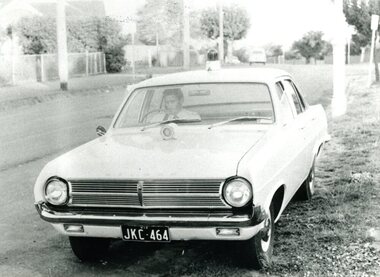
... Holden station car, registration number JKC-464, with blue light on roof and siren on bonnet. Parked in a Kew street. Constable William Robertson driver.Circa 1965...Victoria Police Museum 313 Spencer Street Docklands melbourne police vehicles; motor transport branch; motor transport section; holden car Holden station car, registration number JKC-464, with blue light on roof and siren on bonnet. Parked in a Kew ...Holden station car, registration number JKC-464, with blue light on roof and siren on bonnet. Parked in a Kew street. Constable William Robertson driver.Circa 1965police vehicles; motor transport branch; motor transport section; holden car -
 Kew Historical Society Inc
Photograph - Gates, Victoria Park, 1988
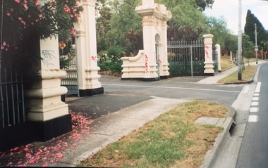
... Colour photographic positive of the former Kew Asylum Gates which were relocated in 1942 to Victoria Park in High Street, Kew. ...Colour photographic positive of the former Kew Asylum Gates which were relocated in 1942 to Victoria Park in High Street, Kew. ...The Kew Asylum Entrance Gateway and an adjacent gate lodge were built at the Princess Street entrance in 1873.1 The imposing sandstone pillars and cast-iron gates impressed upon visitors the therapeutic and civilising vision of the asylum. The entrance opened onto a tree-lined drive (now known as Main Drive) which culminated in an elliptical carriageway in front of the main building. (Heritage Council of Victoria)Colour photographic positive of the former Kew Asylum Gates which were relocated in 1942 to Victoria Park in High Street, Kew. The gates were listed by Heritage Victoria in 2020. The citation reads: "The Former Kew Asylum Entrance Gateway consists of two 4.5 metre sandstone gate piers on bluestone bases on either side of a 5.5 metre vehicle entrance set back from the High Street pavement. The 1870s gate piers are of Barrabool sandstone and repairs during 2015-16 were undertaken with sandstone from English Town, Tasmania. The gate piers are highly decorative and feature oculi, triglyphs, dentils, corbeling and other ornamental work. Each gate pier incorporates a pedestrian archway with a cast-iron pedestrian swing gate. Two curved sections of cast-iron palisade fencing on rusticated bluestone blocks extend from the outer edges of the piers to a set of shorter sandstone pillars on the High Street pavement. Straight sections of cast-iron fence extend 4.5 metres ending at two bluestone pillars. Garden beds have been created within the curved sections of fencing, bordered by concreted bluestone and planted with shrubs." (Heritage Council of Victoria)gates -- kew asylum, gates -- victoria park -- kew (vic.) -
 Emerald Museum & Nobelius Heritage Park
Map - Plan of Survey County of Evelyn Crown Allotment 51, Belgrave - Gembrook Rd. Acquire & declare, Near Lawson Rd, Acquire & declare Crown Allotment 51, Belgrave - Gembrook Rd, c1988
... Emerald Museum & Nobelius Heritage Park 5 Crichton Rd Emerald yarra-valley-and-the-dandenong-ranges RCA/Survey and Mapping/Plan of Survey/ County of Evelyn, Parish of Gembrook, Part of Crown Alloment 51/A.M.G. reference 792/55/364200/5801000/Municipality - Shire of Sherbrooke/Proposed Action Belgrave - Gembrook Road - Acquire & Declare/Plan prepared and signed by John E. Tulloch, 60 Denmark Street, Kew ...Image of Plan of Survey County of Evelyn Crown Allotment 51, Belgrave - Gembrook Rd. Acquire & declare, Near Lawson Rd.RCA/Survey and Mapping/Plan of Survey/ County of Evelyn, Parish of Gembrook, Part of Crown Alloment 51/A.M.G. reference 792/55/364200/5801000/Municipality - Shire of Sherbrooke/Proposed Action Belgrave - Gembrook Road - Acquire & Declare/Plan prepared and signed by John E. Tulloch, 60 Denmark Street, Kew/10th March 1988/Approved Manager of Survey & Mapping - JD Murray 2-6-88/File number 87/17936/1/Survey Register Number 622/SP 17583 -
 Emerald Museum & Nobelius Heritage Park
Map - Acquire & declare action for Belgrave-Gembrook Rd., Emerald 1988, Acquire & declare action for Belgrave-Gembrook Rd., Emerald 1988. near Beaconsfield-Emerald Rd. and Emerald Monbulk Rd, c1988
... Park 5 Crichton Rd Emerald yarra-valley-and-the-dandenong-ranges Land Information and Survey Group/Plan of Survey/Counties of Evelyn and Mornington, Parish of Gembrook, Township of Emerald, Part of a Frmer Govt. Road Section A, Part of Crown Allotment 18, Part of Recreation reserve (Crown Allotment 11C), Part of mechanics Institute & Free Library reserve (Crown Allotment 11B)/AMG Reference 7922/55/363 200/5800700/Municipality - Shire of Sherbrooke/Proposed Action/Belgrave -Gembrook Road acquire & Declare 1 & 4 to 6, revoke and declare 2 & 3.Albert McLaren Road Construction Authority, 60 Denmark Street, Kew/(signed) 5TH December 1988 a.m. ...Image of Map of Acquire & declare action for Belgrave-Gembrook Rd., Emerald 1988 near Beaconsfield-Emerald Rd. and Emerald Monbulk Rd.Land Information and Survey Group/Plan of Survey/Counties of Evelyn and Mornington, Parish of Gembrook, Township of Emerald, Part of a Frmer Govt. Road Section A, Part of Crown Allotment 18, Part of Recreation reserve (Crown Allotment 11C), Part of mechanics Institute & Free Library reserve (Crown Allotment 11B)/AMG Reference 7922/55/363 200/5800700/Municipality - Shire of Sherbrooke/Proposed Action/Belgrave -Gembrook Road acquire & Declare 1 & 4 to 6, revoke and declare 2 & 3.Albert McLaren Road Construction Authority, 60 Denmark Street, Kew/(signed) 5TH December 1988 a.m. LARSEN, licensed surveyor/Approved JD MURRAY, 9/12/88 - Manager - Land Information and Survey Group/SP17861 -
 Emerald Museum & Nobelius Heritage Park
Map - Municipality Road Classification - Wellington Rd. (part), Crown Description - part of Crown Allotment 106 G1, Parish of Narree Worran, c1977
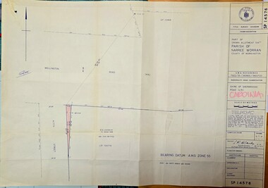
... Emerald Museum & Nobelius Heritage Park 5 Crichton Rd Emerald yarra-valley-and-the-dandenong-ranges SP14576/Title Survey Division/Crown Description/Part of Crown Allotment 106 G1, Parish of Narree Worran, County of Mornington/AMG Reference 7922/55/360800/5800100/Municipality Road Classification/Shire of Sherbrooke Road/Kenneth Douglas Adams, Country Roads Board, 60 Denmark Street, Kew, Surveyor, dated 15th November, 1977/Approved S.R. ...Image of Title Survey, Part of Crown Allotment 106G1, Road Classification Shire of Sherbrooke Rd (Wellington Rd.)SP14576/Title Survey Division/Crown Description/Part of Crown Allotment 106 G1, Parish of Narree Worran, County of Mornington/AMG Reference 7922/55/360800/5800100/Municipality Road Classification/Shire of Sherbrooke Road/Kenneth Douglas Adams, Country Roads Board, 60 Denmark Street, Kew, Surveyor, dated 15th November, 1977/Approved S.R. CLARKE, Principal Surveyor and Proper Officer 21.11.77 -
 Emerald Museum & Nobelius Heritage Park
Map - Plan of Survey Acquire & Declare Proposed Action Belgrave-Gembrook Rd., Shire of Sherbrooke, Plan of Survey acquire and declare proposed action, Belgrave-Gembrook Rd, c1988
... Park 5 Crichton Rd Emerald yarra-valley-and-the-dandenong-ranges SP17861/Land Information and survey Group/Plan of Survey/Counties of Evelyn and Mornington, Parish of Gembrook, Township of Emerald, part of former Govt. Road Section A Part of Crown Allotment 18, Part of recreation Reserve (Crown Allotment 11C), Part of mechanics Institute & Free Library reserve (Crown Allotment 11B)/AMG REFERENCE 7922/55/363200/5800700/municipality, shire of Sherbrooke/Proposed Action, Belgrave-Gembrook Road Acquire & Declare 1 & 4 to 6, revoke & declare 2 & 3/Albert McLaren, Road Construction Authority, 60 Denmark Street, Kew 5th December 1988, (signed) A M Larson, Licensed Surveyor/Approved JD Murray 9/12/88, Manager - Land Information and Survey Group Image of Plan of Survey Acquire & Declare Proposed Action Belgrave-Gembrook Rd., Shire of Sherbrooke Plan of Survey acquire and declare proposed action, Belgrave-Gembrook Rd. ...Image of Plan of Survey Acquire & Declare Proposed Action Belgrave-Gembrook Rd., Shire of SherbrookeSP17861/Land Information and survey Group/Plan of Survey/Counties of Evelyn and Mornington, Parish of Gembrook, Township of Emerald, part of former Govt. Road Section A Part of Crown Allotment 18, Part of recreation Reserve (Crown Allotment 11C), Part of mechanics Institute & Free Library reserve (Crown Allotment 11B)/AMG REFERENCE 7922/55/363200/5800700/municipality, shire of Sherbrooke/Proposed Action, Belgrave-Gembrook Road Acquire & Declare 1 & 4 to 6, revoke & declare 2 & 3/Albert McLaren, Road Construction Authority, 60 Denmark Street, Kew 5th December 1988, (signed) A M Larson, Licensed Surveyor/Approved JD Murray 9/12/88, Manager - Land Information and Survey Group -
 Eltham District Historical Society Inc
Document - Folder, Stanton, Harry
... Park...Chirmside family...Hood and Stanton Malthouse...Mayor of Collingsood...Collingwood Town Hall...Victoria Street Bridge Kew...Harry Stanton Werribbe Park Chirmside family Hood and Stanton Malthouse Mayor of Collingsood Collingwood Town Hall Victoria Street Bridge Kew eltham Bowling Club Guests and Brockoff Yellow Cabs Second Field Regiment Newspaper clippings, A4 photocopies, etc Stanton, Harry Document Folder ...Harry Stanton, whose great-great grandfather laid out the gardens of Werribee Park, ultimately had his own landscaping business after working in many jobs including a family dairy business. Contents Newspaper article: "Harry Stanton reflects on a colorful life", Diamond Valley News, 17 June 1986. Life story of Harry Stanton and his ancestors.Newspaper clippings, A4 photocopies, etcharry stanton, werribbe park, chirmside family, hood and stanton malthouse, mayor of collingsood, collingwood town hall, victoria street bridge kew, eltham bowling club, guests and brockoff, yellow cabs, second field regiment -
 Mission to Seafarers Victoria
Photograph, Seamen standing in front of the house - Findon, Kew
... Mission to Seafarers Victoria 717 Flinders Street Docklands melbourne This house is probably "Findon", Studley Park in Kew, belonging to Mrs Aubrey Bowen, widow of eye surgeon Thomas Aubrey Bowen (1837-1893). ...This house is probably "Findon", Studley Park in Kew, belonging to Mrs Aubrey Bowen, widow of eye surgeon Thomas Aubrey Bowen (1837-1893). She welcomed large groups of seamen (up to 125) for Boxing Day at least on three consecutive years in 1906, 1907, 1908. Small monochrome photograph (faded) depicting outdoor gathering of seamen in front of a building with arches at one of the summer venues.findon, mrs aubrey bowen, thomas aubrey bowen, boxing day, kew, studley park -
 Mission to Seafarers Victoria
Photograph, Cosy Nook Cup Day 1928
... Mission to Seafarers Victoria 717 Flinders Street Docklands melbourne Mr John Innerarity Buchan, Scottish real estate, and his wife. organised at least 4 known outings at their property - Finhaven - in Studley Park, Kew. ...Mr John Innerarity Buchan, Scottish real estate, and his wife. organised at least 4 known outings at their property - Finhaven - in Studley Park, Kew. Those parties were hosted for Cup Day in 1920, 1922, 1924 and 1928. Mr Buchan died in December 1922, but his wife continued with the tradition. The house was sold and demolished in 1941 to create several allotments around Finhaven Court.on page 13 (has been cut)mr john inerrarity buchan, finhaven, studley park, kew, cup day, 1928, fan album -
 Mission to Seafarers Victoria
Photograph - Photograph, Black and White, Ladies preparing lunch Mrs Buchans 1928 Cup Day, November 1928
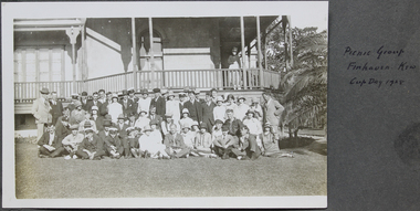
... Mission to Seafarers Victoria 717 Flinders Street Docklands melbourne Mr John Innerarity Buchan, Scottish real estate, and his wife. organised at least 4 known outings at their property - Finhaven - in Studley Park, Kew. ...Mr John Innerarity Buchan, Scottish real estate, and his wife. organised at least 4 known outings at their property - Finhaven - in Studley Park, Kew. Those parties were hosted for Cup Day in 1920, 1922, 1924 and 1928. Mr Buchan died in December 1922, but his wife continued with the tradition. The house was sold and demolished in 1941 to create several allotments around Finhaven Court.on oage 13finhaven, mr john inerrarity buchan, cup day, studley park, kew, reverend john reginald weller (1880-1969), 1928, fan album -
 Mission to Seafarers Victoria
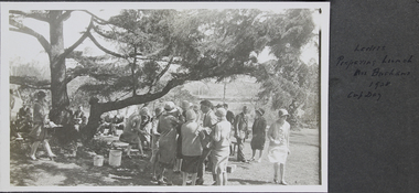
Photograph - Gelatin silver photograph, Picnic group, Finhaven, Kew, Cup Day 1928
... Mission to Seafarers Victoria 717 Flinders Street Docklands melbourne Mr John Innerarity Buchan, Scottish real estate, and his wife. organised at least 4 known outings at their property - Finhaven - in Studley Park, Kew. ...Mr John Innerarity Buchan, Scottish real estate, and his wife. organised at least 4 known outings at their property - Finhaven - in Studley Park, Kew. Those parties were hosted for Cup Day in 1920, 1922, 1924 and 1928. Mr Buchan died in December 1922, but his wife continued with the tradition. The house was sold and demolished in 1941 to create several allotments around Finhaven Court.The photograph was published in the 1928 Annual ReportGroup photograph of men and ladies skiing on the grass and standing in front of a house. Reverend Weller is sitting on the grass in the middle first row. on page 13 (page cut from fan album)Picnic group Finhaven Kew Cup Day 1928 on the album pagefinhaven, mr john inerrarity buchan, mrs buchan, cup day, reverend john reginald weller, 1928, fan album -
 Eltham District Historical Society Inc
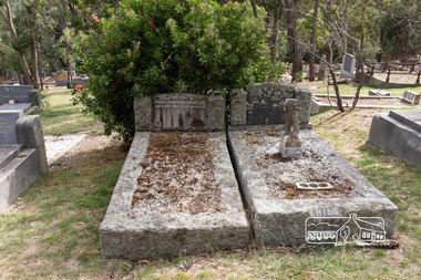
Photograph, Peter Pidgeon, Graves of Mary Josephine Swallow, John Swallow (unmarked) and Patricia Catherine Hill, Eltham Cemetery, Victoria, 5 April 2021
... Kew for four years. John’s body was returned to Eltham Cemetery and buried in the same grave as Mary. There is no mention of his name on the head stone. Patricia’s grave is next to Mary and John. A sad irony has an angel upon her grave, “its head missing”, possibly vandals or just an accident of time and events. What became of the home where all of this took place on New Street shall remain a mystery but within six months of this horrific event, the street had been re-named to Lavender Park...Kew for four years. John’s body was returned to Eltham Cemetery and buried in the same grave as Mary. There is no mention of his name on the head stone. Patricia’s grave is next to Mary and John. A sad irony has an angel upon her grave, “its head missing”, possibly vandals or just an accident of time and events. What became of the home where all of this took place on New Street shall remain a mystery but within six months of this horrific event, the street had been re-named to Lavender Park ...On the 29th of May 1954, a local Eltham carpenter by the name of John Swallow, committed a double murder at his home on New Street. This happened on the same day as the federal election of that year. John 48, his wife Mary 47, and stepdaughter Patricia 25, all went to the Eltham Courthouse on Main Road to cast their vote in the election that Saturday. After voting they returned home to their New Street house around midday. Patricia would later recall to ambulance officers, that she was feeling unwell, and so went to lay down when she heard an argument erupt over voting between her mother Mary and stepfather John. A concerned neighbour heard loud thudding noises and yelling coming from John and Mary’s house, he went to investigate. When he arrived at the house he was met by John at the front door. He would later describe John as “having a frantic look upon his face, and manic eyes”. John must have been a sight, bleeding and clutching a cut throat razor by his side. He then announced to the neighbour, “they voted commie!” before turning and going back inside. The distressed neighbour immediately raced home to call the Police. When the police arrived, they found Mary dead on the kitchen floor from catastrophic head injuries; her daughter, Patricia, clinging to life, slumped on her bed. Both women had been attacked by the same weapon, a large hammer, or sledge hammer as reported by the newspapers. John was also discovered in the house, bleeding from self-inflicted wounds from the razor, and had attempted to ingest caustic soda. Patricia was taken to St Vincent’s hospital, but died the following day, the 30th of May. John was also taken to St Vincent’s, where he remained under constant police guard for several months while he recovered from his injuries, at least the physical. He was eventually well enough to be taken to the City Watch House and then Pentridge Prison before his trial in October of the same year. When it came time for John to face the courts, the Judge called a mistrial, the Crown would not prosecute on the grounds of insanity. John was led away from the dock of The Magistrates Court and taken directly to Willsmere, the Kew Mental Asylum. On the 9th of August 1962, John Mervyn Swallow died of heart failure, he was 57. He had been a resident of Kew for four years. John’s body was returned to Eltham Cemetery and buried in the same grave as Mary. There is no mention of his name on the head stone. Patricia’s grave is next to Mary and John. A sad irony has an angel upon her grave, “its head missing”, possibly vandals or just an accident of time and events. What became of the home where all of this took place on New Street shall remain a mystery but within six months of this horrific event, the street had been re-named to Lavender Park Road after the original property near the end of the road, Lavender Park. In Memory Of Mary Josephine Swallow Died 29th May 1954 aged 47 Also Patricia Cathryn Hill Dearly beloved wife of Kel Called home 30th May 1954 Aged 25 yearsBorn Digitaleltham cemetery, gravestones, mary josephine swallow, patricia catherine hill, john swallow -
 City of Melbourne Libraries
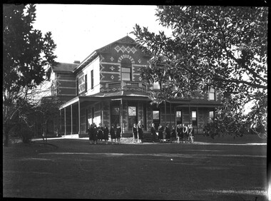
Photograph, Bull, Hugh Jones, 1897-1993, Ruyton Girls School 1933
... The original school, one of Victoria’s oldest independent schools for girls, was located at the home of Mrs Anderson at 63 High Street South, Kew. In 1882 she moved the school to Edgecombe in Studley Park Road. ...The original school, one of Victoria’s oldest independent schools for girls, was located at the home of Mrs Anderson at 63 High Street South, Kew. In 1882 she moved the school to Edgecombe in Studley Park Road. ...Published: Age (Melbourne, Vic.: 1854- ), 4 August 1933, page 3 Published title: GIRLS’ SCHOOLS – MODEL YACHTING - FOOTBALL Published caption: The headmistress, Miss H. Daniell, and girls at Ruyton, Selbourne Road, Kew, snapped after school hours. Trove article identifier: http://nla.gov.au/nla.news-article204381763 Research by Project Volunteer, Louise McKenzie: Rather than the people, this charming building takes the eye! Originally named “Tarring”, it was built in 1872 by Mr Henry Henty and his wife Mrs Marion Anne Henty (nee McKellar) for their family. Located at 82 Selbourne Road, Kew, it is described by Melbourne’s Open House organisation as “… a two-storey, polychrome brick mansion built for them by prominent Melbourne architect Albert Purchas. The house and nearly four acres of grounds served as their family home until the death of Marian Henty in 1919. “ (See below for further information on Albert Purchas.) In 1920 it was sold to Ruyton Girls School. Ruyton was established in 1878 by its first principal, Charlotte Anderson (1838-1906), who named it in honour of the parish in Shropshire, England, Ruyton-XI-Towns, where her great-great-grandfather David Evans had been vicar. Its motto is Recte et Fideliter, meaning "Upright and Faithful", which is also the name of the school song. The original school, one of Victoria’s oldest independent schools for girls, was located at the home of Mrs Anderson at 63 High Street South, Kew. In 1882 she moved the school to Edgecombe in Studley Park Road. Mrs Anderson retired due to ill health and sold the school to her friend Miss Eliza Bromby. One of Ruyton's four Houses, Anderson, is named for Charlotte Anderson. When Ruyton Girls School was moved to the site in 1920 it established the building as a Boarding House, and renamed the building “Henty House” in honour of its original owners. Today the school remains an all girls’ school, and pays tribute to its founder and the historic significance of Henty House and its magnificent Moreton Bay Fig tree, which still stands today. The building retains many original, Victorian-era features, while also showing the layers of change, made over the decades in order to meet the evolving needs of one of Melbourne’s leading schools. The headmistress mentioned in the caption for MCK016 is Miss Hilda Daniell, shown standing in front of Henty House in the midst of a group of Ruyton girls in their school uniforms, some holding hockey sticks. Miss Daniell was the longest serving Principal of Ruyton 1913-1952. She was originally a student in 1893, then joined the teaching staff in 1898. It was under her leadership that the School purchased and moved to “Tarring”. The boarding house included a flat for Hilda to live onsite. An article in the Ruyton Heritage Collection – Bedford Series, dated 21 May 2021 cites that Miss Daniell “was affectionately known as “Dream” by Ruytonians of her era” apparently due to a tendency to quiet reflection. The article continues, “After her retirement in 1952 Miss Daniell was awarded an Order of the British Empire for her many services to education, an award she received from the hands of the Queen during the 1954 Royal Tour. Also in 1952, the Kew Council honoured her by renaming Brougham Place as ‘Daniell Place’.” Arthur Purchas, architect: The architect responsible for the design of “Tarring”. Arthur Purchas, was extremely active and highly regarded at this time. Born in Wales in 1825, he emigrated to Melbourne in 1851 and soon established a private practice as a surveyor and architect, with offices variously in Little Collins, Queen Street, Chancery Lane, and finally 462 Little Collins Street. Wikipedia notes in an early reference to Purchas that “An early story is that one of his first jobs, when he would have been about 25 years old, was a position under Surveyor-General Robert Hoddle, and disagreeing with him over the line for St Kilda Road, appealed to Governor La Trobe, and successfully got the road diverted around the hill which eventually became the site of the Shrine of Remembrance. There may not be much truth to this, since by 1851 St Kilda Road was already a well worn track running around the hill, the top of which La Trobe had reserved for a Government House in 1840.” The timing of Purchas’s arrival in Melbourne was perfect. The Victorian gold rush of the 1850’s generated enormous wealth in Melbourne, and a building boom followed. The Wikipedia entry continues … that alone, or with his brother in law Charles R Swyer, “Purchas is said to have designed over 140 houses, offices, churches, banks and cemetery buildings in Victoria in his long career. Berkely Hall, St Kilda dating from 1854 is one of his first buildings, and still exists, though the original house is obscured by an early C20th verandah. Another notable early design was the head office of the Melbourne Savings Bank, built on the corner Flinders Lane and Market Street in 1857-58, in an elaborately detailed Renaissance Revival style. His churches were mostly Gothic Revival, built for the Anglican Church, along with some parsonages, while most of the bank buildings were Renaissance Revival designs for the Bank of Australasia. He also designed city buildings in the 1860s and 70s, such as the Mutual Insurance Co, Northern Insurance Co, and the first premises for George & George, destroyed by fire in 1889. One of his most outstanding designs is St George's Presbyterian Church in Chapel Street, St Kilda (1877–80), in a striking polychrome brick Gothic Revival style, unusually carried on through to the interior. Purchas produced one of the few published maps and compilations of the early pastoral settlers runs in Victoria in 1853. In the same year he designed the layout of the Melbourne General Cemetery, the first 'garden' cemetery in Victoria, a curvilinear layout with extensive plantings, as well as the gate lodge and gates (the gates lodge were demolished and the gates relocated to their present position in the 1930s). He was a long time member of the Cemetery Trust, serving as secretary from 1876-1886. He was also Chairman of the Boroondara General Cemetery Board of Trustees 1867 to 1909, and designed many aspects of the cemetery, including the landscape, the cast iron entrance gates (1889), the rotunda (1890) and the surrounding brick wall (1895–6). Purchas was a keen inventor having applied for a patent for an invention for lighting a railway carriage with gas in 1861, and won a competition for a model farm complex, in 1862. This unusual design had the dairy either underground or half underground, to keep it cool, with a 'dry lining' around the outside of the sunken portions. In 1883, with fellow architect Alfred Smith, he took out a patent for fire-proof floors, arches, staircases and other parts of buildings.” Purchas died in his home in Kew in 1909 and, not surprisingly, was buried at Boroondara Cemetery. Henty family history in Australia: Henry Henty (b.1833-d.1912) was a successful businessman, and briefly a MLA for the seat of Grenville, Victoria in 1866. He was one of three sons of James Henty, and nephew of Edward Henty who is considered to be the first permanent European colonist to take up residence in Victoria. The Australian Dictionary of Biography provides a riveting overview of the complex and enthusiastic activities of the Henty family, and its entanglement in the development of mercantile life in WA, Tasmania, SA and Victoria from 1828 onwards. The family had a focussed commitment to creating thriving businesses in Australia, despite being regularly thwarted by legislative pushbacks and law changes, instigated in Britain as the Australian colony developed. Areas of greatest influence were merino sheep, beef and horse breeding, whaling, farm establishment, membership of the legal and political fraternities, sporting prowess, and board directorships in banking and railways. The Dictionary of Biography summarises: “As settlers the Henty men were notable not merely for being the first to settle in Victoria but also for their number and quality: a father and seven educated sons experienced in farming and trading, occupations of prime importance to a new colony, and importers of unusually substantial capital in money, skilled workers and thoroughbred stock.” As well as Tarring, the Henty family Melbourne residences included Findon (in Kew, overlooking Studley Park), Offington (St Kilda Road overlooking Albert Park) and Field Place (Henty Court, Kew), and descriptions of the houses in Wikipedia –Melbourne Architecture 1870s - reflect the development of Melbourne society. References RUYTON (1934, December 15). The Argus (Melbourne, Vic. : 1848 - 1957), p. 18. Retrieved March 12, 2025, from http://nla.gov.au/nla.news-article11001092 https://en.wikipedia.org/wiki/Ruyton_Girls%27_School#:~:text=Ruyton%20Girls'%20School%2C%20commonly%20referred,of%20Melbourne%2C%20Victoria%2C%20Australia. https://www.ruyton.vic.edu.au/our-school#:~:text=With%20an%20international%20reputation%20as,opportunity%20and%20challenge%20for%20girls. https://victoriancollections.net.au/items/5bea06b121ea690bf4eb08ed https://www.ruyton.vic.edu.au/our-school/campus-and-facilities Biography of Edward Henty and family: https://adb.anu.edu.au/biography/henty-edward-2247 Article on Offington House: http://nla.gov.au/nla.news-article196554993 Article on Field Place House : https://vhd.heritagecouncil.vic.gov.au/places/64881 Article on Findon: https://www.facebook.com/KewHistoryGroup/posts/in-the-book-jubilee-history-of-kew-1803-1910-by-fga-barnard-there-is-a-photo-of-/4389837914376555/ Charlotte Anderson/Ruyton: https://victoriancollections.net.au/items/5be4b8c821ea6a039c7a13e3 https://victoriancollections.net.au/items/6179e90da912eb195970bdf8 https://victoriancollections.net.au/items/5bea06b121ea690bf4eb08ed https://victoriancollections.net.au/items/65d3e05c5b5e5c61346420a2 Photo of Charlotte Anderson: https://viewer.slv.vic.gov.au/?entity=IE1515776&mode=browse Photo of Charlotte Anderson: https://victoriancollections.net.au/items/6179e90da912eb195970bdf8 https://victoriancollections.net.au/items/5be4b8c821ea6a039c7a13e3 Wikipedia: Architecture of Melbourne: https://en.wikipedia.org/wiki/Architecture_of_Melbourne Open House Melbourne: Henty House: https://www.universe.com/events/henty-house-ruyton-girls-school-tickets-Z45LYH Albert Purchas: https://en.wikipedia.org/wiki/Albert_Purchas Leader (Melbourne, Vic. : 1862 - 1918, 1935), Saturday 3 June 1876, page 9 – Article on Offington http://www.ohta.org.au/organs/organs/BoxHillUC.html Melb Architecture 1870s - Wikipedia Victorian Collections: Letters of Hilda Daniell https://victoriancollections.net.au/items/65d3e05c5b5e5c61346420a2 Photographer notations on slide: "Ruyton Girls School 1933".schools, 1930-1939, architecture, victorian architecture, trees, architects -
 Melbourne Tram Museum
Album - Robert Thomson Slide Collection, AETA Convention 1978 Melbourne
... Number Brief Description RT175 St Kilda Carlisle St - tram 966 - "Kew Cotham Rd" - route 69 RT176 Pantograph W Class RT177 Z Class 91 Preston 28-3-78 - tram 91 - " Northcote Dundas St via High St" RT178 Z Class cars Preston 28-3-78 RT179 Wheel Transport Car 16W "Q" Class Preston 28-3-78 RT180 Z Class 51 Royal Park Res Track 27-3-78 - tram 51 -"Special" RT181 W6 - 990 - Glen Iris Terminus 26-3-78 "City" - route 6 RT182 w7-1007 Elizabeth Street Terminus 24-3-73 "Essendon Airport" - route 59 RT183 Z Class 51 Napier St Siding Essendon 27-3-78 - "City" RT184 Volvo Bus Swanston - Flinders 24-3-78 - "Bulleen via North Kew" - route 202 RT185 W6 - 878 Burwood Old Terminus 26-3-78 - "Spencer St" - route 74 RT186 W6 - 878 Burwood Old Terminus 26-3-78 - "Spencer St" - route 75 RT187 East Burwood Andrews Street 26-3-78 RT188 East Burwood Elgar Road 26-3-78 RT189 East Burwood Reservation Parer Street 26-3-78 RT190 East Burwood Terminus 26-3-78 RT191 East Burwood Terminus 26-3-78 RT192 "6" RT193 "5" RT194 "4" RT195 "3" RT196 "2" RT197 "1" Z Cars under construction...Number Brief Description RT175 St Kilda Carlisle St - tram 966 - "Kew Cotham Rd" - route 69 RT176 Pantograph W Class RT177 Z Class 91 Preston 28-3-78 - tram 91 - " Northcote Dundas St via High St" RT178 Z Class cars Preston 28-3-78 RT179 Wheel Transport Car 16W "Q" Class Preston 28-3-78 RT180 Z Class 51 Royal Park Res Track 27-3-78 - tram 51 -"Special" RT181 W6 - 990 - Glen Iris Terminus 26-3-78 "City" - route 6 RT182 w7-1007 Elizabeth Street Terminus 24-3-73 "Essendon Airport" - route 59 RT183 Z Class 51 Napier St Siding Essendon 27-3-78 - "City" RT184 Volvo Bus Swanston - Flinders 24-3-78 - "Bulleen via North Kew" - route 202 RT185 W6 - 878 Burwood Old Terminus 26-3-78 - "Spencer St" - route 74 RT186 W6 - 878 Burwood Old Terminus 26-3-78 - "Spencer St" - route 75 RT187 East Burwood Andrews Street 26-3-78 RT188 East Burwood Elgar Road 26-3-78 RT189 East Burwood Reservation Parer Street 26-3-78 RT190 East Burwood Terminus 26-3-78 RT191 East Burwood Terminus 26-3-78 RT192 "6" RT193 "5" RT194 "4" RT195 "3" RT196 "2" RT197 "1" Z Cars under construction Demonstrates the work of Robert Thomson in photography, collection and/or production of slides Melbourne tramways trams Assembled album in a black presentation folder of 23 colour slides, collected or produced by Robert Thomson. ...Photo - see pdf file for further information. Number Brief Description RT175 St Kilda Carlisle St - tram 966 - "Kew Cotham Rd" - route 69 RT176 Pantograph W Class RT177 Z Class 91 Preston 28-3-78 - tram 91 - " Northcote Dundas St via High St" RT178 Z Class cars Preston 28-3-78 RT179 Wheel Transport Car 16W "Q" Class Preston 28-3-78 RT180 Z Class 51 Royal Park Res Track 27-3-78 - tram 51 -"Special" RT181 W6 - 990 - Glen Iris Terminus 26-3-78 "City" - route 6 RT182 w7-1007 Elizabeth Street Terminus 24-3-73 "Essendon Airport" - route 59 RT183 Z Class 51 Napier St Siding Essendon 27-3-78 - "City" RT184 Volvo Bus Swanston - Flinders 24-3-78 - "Bulleen via North Kew" - route 202 RT185 W6 - 878 Burwood Old Terminus 26-3-78 - "Spencer St" - route 74 RT186 W6 - 878 Burwood Old Terminus 26-3-78 - "Spencer St" - route 75 RT187 East Burwood Andrews Street 26-3-78 RT188 East Burwood Elgar Road 26-3-78 RT189 East Burwood Reservation Parer Street 26-3-78 RT190 East Burwood Terminus 26-3-78 RT191 East Burwood Terminus 26-3-78 RT192 "6" RT193 "5" RT194 "4" RT195 "3" RT196 "2" RT197 "1" Z Cars under constructionDemonstrates the work of Robert Thomson in photography, collection and/or production of slidesAssembled album in a black presentation folder of 23 colour slides, collected or produced by Robert Thomson. All photographs have been scanned and placed on the Museum's G drive. A list of all photographs with details has been compiled. melbourne, tramways, trams -
 Ruyton Girls' School
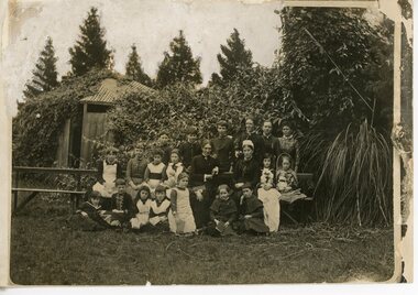
Photograph - Group photograph, Mrs Charlotte Anderson with younger students, Original image: 1885 circa
... In 1878, Mrs Charlotte Anderson founded an private school for girls in her home at Bulleen Road, Kew (now 63 High Street South, Kew). She moved her school to ‘Edgecomb’, in Studley Park Road in 1882 and named it Ruyton. ...Ruyton Girls' School 12 Selbourne Road Kew melbourne In 1878, Mrs Charlotte Anderson founded an private school for girls in her home at Bulleen Road, Kew (now 63 High Street South, Kew). She moved her school to ‘Edgecomb’, in Studley Park Road in 1882 and named it Ruyton. ...In 1878, Mrs Charlotte Anderson founded an private school for girls in her home at Bulleen Road, Kew (now 63 High Street South, Kew). She moved her school to ‘Edgecomb’, in Studley Park Road in 1882 and named it Ruyton. Charlotte Anderson retired in 1888, and sold her school to Miss Eliza Bromby. This image was used to illustrate The Ruytonian, June 1915, p2. The date of manufacture of the duplicate photograph is unknown.Black & white duplicate photograph of Mrs Charlotte Anderson with staff and a group of younger students from Ruyton Girls’ School, c.1885. The group is arranged in three rows of seated and standing individuals, and is located on a garden setting. The photograph was taken at ‘Edgecomb’, Studley Park Road, Kew which was the location of Ruyton from 1882-1888. Mrs Anderson is seated in the middle row, third from right. ruyton girls' school, kew, charlotte anderson -
 Ruyton Girls' School
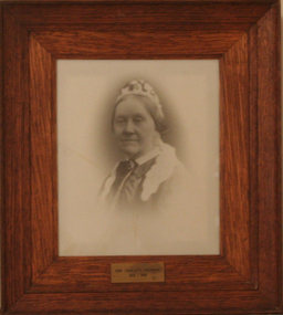
Photograph - Photographic Portrait, Mrs Charlotte Anderson
... Kew (Vic)...Bulleen Road...High Street South...Studley Park...Charlotte Anderson Ruyton Ruyton Girls' School Kew (Vic) Bulleen Road High Street South Studley Park Road Edgecomb woman school teacher principal Anderson reproduction 1990s Plaque on frame: "Mrs Charlotte Anderson/ 1878-1888" A framed, black & white reproduction of a photographic portrait. ...Mrs Charlotte Anderson was born Charlotte Eliza Alsop in England in 1838 and arrived in Australia in 1848. She married lawyer James Anderson in 1864, and in the year of his death in 1878 she became the founding owner-Principal of Ruyton Girls' School, Kew. Mrs Anderson operated Ruyton initially in her own home of 63 Bulleen Road, Kew (now 63 High Street South). According to Ruyton histories, Mrs Anderson is said to have begun the school with her own two sons, four daughters and some of her Alsop nieces and nephews who resided in Kew. Around the time of the addition of Maud King, the first student outside the family, the school changed to a 'Ladies College', and the boys were sent elsewhere for their education. By late 1881 Mrs Anderson began using the name 'Ruyton' for the school, in honour of a connection to Ruyton-XI-Towns, Shropshire, England where her great-grandfather had been vicar and where she was baptised. In 1882 Mrs Anderson moved the School to Edgecomb in Studley Park Road from 1882-1888. The larger premises enabled her to begin accepting boarding students from 1882. She retired due to ill health and sold the school to her friend Miss Eliza Bromby. Mrs Anderson lived at 'Bongamero', in the King Valley, Victoria until her death in 1906. She is buried in Boroondara Cemetery. One of Ruyton's four Houses, Anderson, is named for Charlotte Anderson. Artwork AC/0099 is a framed reproduction photograph of an original portrait of Mrs Anderson, c.1900-1906. The location and date of the original photograph is unknown, but may be held among Ruyton papers at the State Library of Victoria (MS 12079). The reproduction was probably created to be part of the gallery of Principals and significant people for the Conference/Boardroom, Henty House.A framed, black & white reproduction of a photographic portrait. The portrait shows the head and shoulders of a middle aged woman wearing Victorian-era clothing including a dark ribbon tied around her collar. She wears a lace cap on her head, and the cap's tail is draped around her shoulders. The woman's body is partially turned away from the camera, while her face is turned toward the camera. Plaque on frame: "Mrs Charlotte Anderson/ 1878-1888"charlotte anderson, ruyton, ruyton girls' school, kew (vic), bulleen road, high street south, studley park road, edgecomb, woman, school, teacher, principal, anderson, reproduction, 1990s -
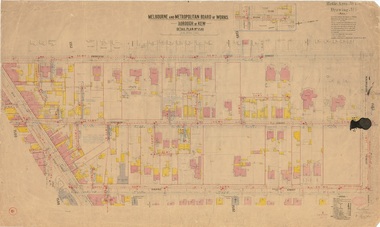
 Kew Historical Society Inc
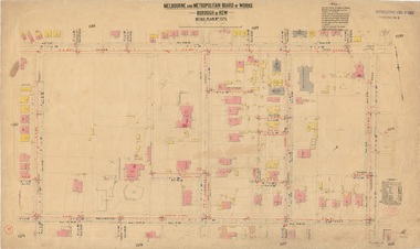
Plan, Melbourne & Metropolitan Board of Works : Borough of Kew : Detail Plan No.1576, 1904
... Street Kew melbourne The Melbourne and Metropolitan Board of Works (MMBW) plans were produced from the 1890s to the 1950s. They were crucial to the design and development of Melbourne's sewerage and drainage system. The plans, at a scale of 40 feet to 1 inch (1:480), provide a detailed historical record of Melbourne streetscapes and environmental features. Each plan covers one or two street blocks (roughly six streets), showing details of buildings, including garden layouts and ownership boundaries, and features such as laneways, drains, bridges, parks ...The Melbourne and Metropolitan Board of Works (MMBW) plans were produced from the 1890s to the 1950s. They were crucial to the design and development of Melbourne's sewerage and drainage system. The plans, at a scale of 40 feet to 1 inch (1:480), provide a detailed historical record of Melbourne streetscapes and environmental features. Each plan covers one or two street blocks (roughly six streets), showing details of buildings, including garden layouts and ownership boundaries, and features such as laneways, drains, bridges, parks, municipal boundaries and other prominent landmarks as they existed at the time each plan was produced. (Source: State Library of Victoria)This plan forms part of a large group of MMBW plans and maps that was donated to the Society by the Mr Poulter, City Engineer of the City of Kew in 1989. Within this collection, thirty-five hand-coloured plans, backed with linen, are of statewide significance as they include annotations that provide details of construction materials used in buildings in the first decade of the 20th century as well as additional information about land ownership and usage. The copies in the Public Record Office Victoria and the State Library of Victoria are monochrome versions which do not denote building materials so that the maps in this collection are invaluable and unique tools for researchers and heritage consultants. A number of the plans are not held in the collection of the State Library of Victoria so they have the additional attribute of rarity.Original survey plan, issued by the MMBW to a contractor with responsibility for constructing sewers in the area identified on the plan within the Borough of Kew. The plan was at some stage hand-coloured, possibly by the contractor, but more likely by officers working in the Engineering Department of the Borough and later Town, then City of Kew. The hand-coloured sections of buildings on the plan were used to denote masonry or brick constructions (pink), weatherboard constructions (yellow), and public buildings (grey). Development in the 20th century has irreparably altered that part of Kew represented in this plan. In the block bounded by Cotham Road, Charles Street, Wellington Street and Gellibrand; just one house standing in 1903 remains. This block included two of the most historic houses in Kew: ‘Ordsall’ (later ‘Southesk’) and ‘Madford’ (previously ‘Elm Lodge’). Ordsall was the home of the second chairman of Kew, John Halfey. It contained some of the most significant interior murals in Kew, created for Halfey by artists working for Cullen & Co. It was demolished in 1960 to make way for the Kew Civic Centre. Elm Lodge had been built for William Siddeley in ca. 1864. Arthur Septimus King purchased it in 1874. The lower paddocks of Madford were sold in 1905 by his wife to the Borough of Kew and, after landscaping by George and Thomas Pockett, opened as the Alexandra Gardens in 1908. Elm Lodge/Madford was in 1922 to become St. Anthony’s Home for Little Children before its subsequent demolition in the 1980s.melbourne and metropolitan board of works, detail plans, maps - borough of kew, mmbw 1576, cartography -
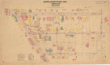
 Kew Historical Society Inc
Plan, Borough of Kew Detail Plan No.1577, 1904
... Street Kew melbourne The Melbourne and Metropolitan Board of Works (MMBW) plans were produced from the 1890s to the 1950s. They were crucial to the design and development of Melbourne's sewerage and drainage system. The plans, at a scale of 40 feet to 1 inch (1:480), provide a detailed historical record of Melbourne streetscapes and environmental features. Each plan covers one or two street blocks (roughly six streets), showing details of buildings, including garden layouts and ownership boundaries, and features such as laneways, drains, bridges, parks ...The Melbourne and Metropolitan Board of Works (MMBW) plans were produced from the 1890s to the 1950s. They were crucial to the design and development of Melbourne's sewerage and drainage system. The plans, at a scale of 40 feet to 1 inch (1:480), provide a detailed historical record of Melbourne streetscapes and environmental features. Each plan covers one or two street blocks (roughly six streets), showing details of buildings, including garden layouts and ownership boundaries, and features such as laneways, drains, bridges, parks, municipal boundaries and other prominent landmarks as they existed at the time each plan was produced. (Source: State Library of Victoria)This plan forms part of a large group of MMBW plans and maps that was donated to the Society by the Mr Poulter, City Engineer of the City of Kew in 1989. Within this collection, thirty-five hand-coloured plans, backed with linen, are of statewide significance as they include annotations that provide details of construction materials used in buildings in the first decade of the 20th century as well as additional information about land ownership and usage. The copies in the Public Record Office Victoria and the State Library of Victoria are monochrome versions which do not denote building materials so that the maps in this collection are invaluable and unique tools for researchers and heritage consultants. A number of the plans are not held in the collection of the State Library of Victoria so they have the additional attribute of rarity.Original survey plan, issued by the MMBW to a contractor with responsibility for constructing sewers in the area identified on the plan within the Borough of Kew. The plan was at some stage hand-coloured, possibly by the contractor, but more likely by officers working in the Engineering Department of the Borough and later Town, then City of Kew. The hand-coloured sections of buildings on the plan were used to denote masonry or brick constructions (pink), weatherboard constructions (yellow), and public buildings (grey). MMBW Plan No.1577 includes some of the most significant houses in Kew: Herbert Henty’s ‘Roxeth’ (now part of Trinity Grammar), ‘Butleigh Wooton’, ‘Bokara’ and ‘Harrow’. It also includes the streets that have since changed their names. That part of College Parade linked to Glenferrie Road is now named College Place, College Parade now extends further north, and Charles Street did not yet reach Barkers Road. Roxeth is one of a number of Henty houses in Kew. Herbert Henty made his home here and was elected a member of Kew Municipal Council in 1864 and mayor in 1868-69. Walter Henry Serle, of Harrow served in the First World War. He was awarded the Military Medal ‘’For conspicuous bravery and devotion to duty. On 29th September near BELLICOURT he showed the greatest bravery and determination when his platoon was attacked by enemy bombing parties. It was due largely to his personal efforts that all the attacks were repulsed. Until wounded, his utter disregard of personal safety and boldness in dealing with the attacks were the means of saving the situation and were an inspiring example to his men.’melbourne and metropolitan board of works, detail plans, maps - borough of kew, mmbw 1577, cartography -
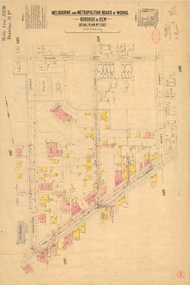
 Kew Historical Society Inc
Plan, Melbourne & Metropolitan Board of Works : Borough of Kew : Detail Plan No.1578, 1904
... Street Kew melbourne The Melbourne and Metropolitan Board of Works (MMBW) plans were produced from the 1890s to the 1950s. They were crucial to the design and development of Melbourne's sewerage and drainage system. The plans, at a scale of 40 feet to 1 inch (1:480), provide a detailed historical record of Melbourne streetscapes and environmental features. Each plan covers one or two street blocks (roughly six streets), showing details of buildings, including garden layouts and ownership boundaries, and features such as laneways, drains, bridges, parks ...The Melbourne and Metropolitan Board of Works (MMBW) plans were produced from the 1890s to the 1950s. They were crucial to the design and development of Melbourne's sewerage and drainage system. The plans, at a scale of 40 feet to 1 inch (1:480), provide a detailed historical record of Melbourne streetscapes and environmental features. Each plan covers one or two street blocks (roughly six streets), showing details of buildings, including garden layouts and ownership boundaries, and features such as laneways, drains, bridges, parks, municipal boundaries and other prominent landmarks as they existed at the time each plan was produced. (Source: State Library of Victoria). This plan forms part of a large group of MMBW plans and maps that was donated to the Society by the Mr Poulter, City Engineer of the City of Kew in 1989. Within this collection, thirty-five hand-coloured plans, backed with linen, are of statewide significance as they include annotations that provide details of construction materials used in buildings in the first decade of the 20th century as well as additional information about land ownership and usage. The copies in the Public Record Office Victoria and the State Library of Victoria are monochrome versions which do not denote building materials so that the maps in this collection are invaluable and unique tools for researchers and heritage consultants. A number of the plans are not held in the collection of the State Library of Victoria so they have the additional attribute of rarity.Original survey plan, issued by the MMBW to a contractor with responsibility for constructing sewers in the area identified on the plan within the Borough of Kew. The plan was at some stage hand-coloured, possibly by the contractor, but more likely by officers working in the Engineering Department of the Borough and later Town, then City of Kew. The hand-coloured sections of buildings on the plan were used to denote masonry or brick constructions (pink), weatherboard constructions (yellow), and public buildings (grey). MMBW Plan No.1578 is significant in that it defines the extent of two private schools: Xavier College and Kew High School (now part of Trinity Grammar) by 1904. In relation to the latter, the plan clarifies which buildings the High School operated from behind the mansion ‘Molina’. Established in 1902, Trinity Grammar was to later lease and subsequently buy Molina (now ‘Merritt House’) and ‘Elsinore’ (now ‘Roberts House’). Xavier College had been established in 1872. This 1904 plan delineates the West Wing and the Great Hall (built in 1890).melbourne and metropolitan board of works, detail plans, maps - borough of kew, mmbw 1578, cartography -
 Kew Historical Society Inc
Plan, Melbourne & Metropolitan Board of Works. Borough of Kew Detail Plan No.1579, 1904
... Street Kew melbourne The Melbourne and Metropolitan Board of Works (MMBW) plans were produced from the 1890s to the 1950s. They were crucial to the design and development of Melbourne's sewerage and drainage system. The plans, at a scale of 40 feet to 1 inch (1:480), provide a detailed historical record of Melbourne streetscapes and environmental features. Each plan covers one or two street blocks (roughly six streets), showing details of buildings, including garden layouts and ownership boundaries, and features such as laneways, drains, bridges, parks ...The Melbourne and Metropolitan Board of Works (MMBW) plans were produced from the 1890s to the 1950s. They were crucial to the design and development of Melbourne's sewerage and drainage system. The plans, at a scale of 40 feet to 1 inch (1:480), provide a detailed historical record of Melbourne streetscapes and environmental features. Each plan covers one or two street blocks (roughly six streets), showing details of buildings, including garden layouts and ownership boundaries, and features such as laneways, drains, bridges, parks, municipal boundaries and other prominent landmarks as they existed at the time each plan was produced. (Source: State Library of Victoria). This plan forms part of a large group of MMBW plans and maps that was donated to the Society by the Mr Poulter, City Engineer of the City of Kew in 1989. Within this collection, thirty-five hand-coloured plans, backed with linen, are of statewide significance as they include annotations that provide details of construction materials used in buildings in the first decade of the 20th century as well as additional information about land ownership and usage. The copies in the Public Record Office Victoria and the State Library of Victoria are monochrome versions which do not denote building materials so that the maps in this collection are invaluable and unique tools for researchers and heritage consultants. A number of the plans are not held in the collection of the State Library of Victoria so they have the additional attribute of rarity.Original survey plan, issued by the MMBW to a contractor with responsibility for constructing sewers in the area identified on the plan within the Borough of Kew. The plan was at some stage hand-coloured, possibly by the contractor, but more likely by officers working in the Engineering Department of the Borough and later Town, then City of Kew. The hand-coloured sections of buildings on the plan were used to denote masonry or brick constructions (pink), weatherboard constructions (yellow), and public buildings (grey). While MMBW Plan No.1579 does not include many buildings, those that it does show are significant to Kew’s history. These include the ‘Kew [Railway] Station’ in Denmark Street and the ‘Recreation Hall’ and rear courts off Wellington Street. The plan shows the outline of the Recreation Hall, constructed in 1880, at the rear of which is listed a bowling green, two tennis courts, a ‘skittle alley’ and a pavilion. When the Hall was first built, the Kew Cricket Club occupied an adjacent ground, however in 1885 this was acquired by the State Government as the future location of the Kew Railway Station. The Plan also shows a single oval at Xavier College. This oval was completed in 1883. One of the current ovals conforms to this oval’s original shape and position in the school grounds.melbourne and metropolitan board of works, detail plans, maps - borough of kew, mmbw 1579, cartography -
 Kew Historical Society Inc
Plan, Melbourne and Metropolitan Board of Works, Borough of Kew : Detail Plan No.1580, 1904
... Street Kew melbourne The Melbourne and Metropolitan Board of Works (MMBW) plans were produced from the 1890s to the 1950s. They were crucial to the design and development of Melbourne's sewerage and drainage system. The plans, at a scale of 40 feet to 1 inch (1:480), provide a detailed historical record of Melbourne streetscapes and environmental features. Each plan covers one or two street blocks (roughly six streets), showing details of buildings, including garden layouts and ownership boundaries, and features such as laneways, drains, bridges, parks ...The Melbourne and Metropolitan Board of Works (MMBW) plans were produced from the 1890s to the 1950s. They were crucial to the design and development of Melbourne's sewerage and drainage system. The plans, at a scale of 40 feet to 1 inch (1:480), provide a detailed historical record of Melbourne streetscapes and environmental features. Each plan covers one or two street blocks (roughly six streets), showing details of buildings, including garden layouts and ownership boundaries, and features such as laneways, drains, bridges, parks, municipal boundaries and other prominent landmarks as they existed at the time each plan was produced. (Source: State Library of Victoria)This plan forms part of a large group of MMBW plans and maps that was donated to the Society by the Mr Poulter, City Engineer of the City of Kew in 1989. Within this collection, thirty-five hand-coloured plans, backed with linen, are of statewide significance as they include annotations that provide details of construction materials used in buildings in the first decade of the 20th century as well as additional information about land ownership and usage. The copies in the Public Record Office Victoria and the State Library of Victoria are monochrome versions which do not denote building materials so that the maps in this collection are invaluable and unique tools for researchers and heritage consultants. A number of the plans are not held in the collection of the State Library of Victoria so they have the additional attribute of rarity.Original survey plan, issued by the MMBW to a contractor with responsibility for constructing sewers in the area identified on the plan within the Borough of Kew. The plan was at some stage hand-coloured, possibly by the contractor, but more likely by officers working in the Engineering Department of the Borough and later Town, then City of Kew. The hand-coloured sections of buildings on the plan were used to denote masonry or brick constructions (pink), weatherboard constructions (yellow), and public buildings (grey). The area represented in this detail plan has undergone significant change during the 20th century. The widening of High Street in the 1930s and 1950s involved the shops on the south side of High Street being demolished and later rebuilt to fit the widened street. Another significant loss was the mansion ‘Drayton’ fronting Wellington Street, owned at this stage by Susannah Fenton. Her family name would later to be given to Fenton Way, which was to be built over the grounds of the house following its demolition. The plan of the garden is particularly interesting, containing a batten dome fronting Wellington Street, an ornamental pond, a fountain and a brick and glass conservatory. The notes by the plumbing contractor on this plan are particularly detailed. Pink borders delineate the ownership of the varying parcels of land. Some of the better known owners listed include the real estate agent Cr. Henry de Castres Kellett (bt) and John Padbury, the funeral director. This particular plan provides a clear view of the configuration of the Kew Junction in 1903 and the commercial buildings that surrounded it.melbourne and metropolitan board of works, detail plans, maps - borough of kew, mmbw 1580, cartography -
 Kew Historical Society Inc
Plan, Melbourne & Metropolitan Board of Works : Borough of Kew : Detail Plan No.1581, 1904
... Street Kew melbourne The Melbourne and Metropolitan Board of Works (MMBW) plans were produced from the 1890s to the 1950s. They were crucial to the design and development of Melbourne's sewerage and drainage system. The plans, at a scale of 40 feet to 1 inch (1:480), provide a detailed historical record of Melbourne streetscapes and environmental features. Each plan covers one or two street blocks (roughly six streets), showing details of buildings, including garden layouts and ownership boundaries, and features such as laneways, drains, bridges, parks ...The Melbourne and Metropolitan Board of Works (MMBW) plans were produced from the 1890s to the 1950s. They were crucial to the design and development of Melbourne's sewerage and drainage system. The plans, at a scale of 40 feet to 1 inch (1:480), provide a detailed historical record of Melbourne streetscapes and environmental features. Each plan covers one or two street blocks (roughly six streets), showing details of buildings, including garden layouts and ownership boundaries, and features such as laneways, drains, bridges, parks, municipal boundaries and other prominent landmarks as they existed at the time each plan was produced. (Source: State Library of Victoria)This plan forms part of a large group of MMBW plans and maps that was donated to the Society by the Mr Poulter, City Engineer of the City of Kew in 1989. Within this collection, thirty-five hand-coloured plans, backed with linen, are of statewide significance as they include annotations that provide details of construction materials used in buildings in the first decade of the 20th century as well as additional information about land ownership and usage. The copies in the Public Record Office Victoria and the State Library of Victoria are monochrome versions which do not denote building materials so that the maps in this collection are invaluable and unique tools for researchers and heritage consultants. A number of the plans are not held in the collection of the State Library of Victoria so they have the additional attribute of rarity.Original survey plan, issued by the MMBW to a contractor with responsibility for constructing sewers in the area identified on the plan within the Borough of Kew. The plan was at some stage hand-coloured, possibly by the contractor, but more likely by officers working in the Engineering Department of the Borough and later Town, then City of Kew. The hand-coloured sections of buildings on the plan were used to denote masonry or brick constructions (pink), weatherboard constructions (yellow), and public buildings (grey). The streets and built structures in this plan were surveyed in 1903 and released to contractors in 1904. In addition to the designation of building types by colour, the plan includes detailed descriptions of land use and ownership. While many buildings remain from this period, a number of the buildings represented have been demolished including the original Kew Town Hall, and the Congregational and Roman Catholic churches in Walpole Street. While the mansion ‘Illapa’ in Princess Street is still extant – now part of ‘Rylands’ – the neighbouring mansion ‘Elsmere’ was demolished some decades ago. Rivalling Illapa and Elsmere in size were two mansions in Walpole Street, one named on the plan as ‘Gnarlbine’. Over time, Kew Junction and the south side of High Street have been reconfigured and widened, so that the commercial buildings on the corner of Princess and High Street no longer exist. A surprising feature of this part of central Kew to the northwest of Kew Junction is the amount of vacant land. In a number of cases, this land is noted by the contractor as used for vegetable gardens.melbourne and metropolitan board of works, detail plans, maps - borough of kew, mmbw 1581, cartography -
 Kew Historical Society Inc
Plan, Melbourne & Metropolitan Board of Works : Borough of Kew : Detail Plan No.1582, 1904
... Street Kew melbourne The Melbourne and Metropolitan Board of Works (MMBW) plans were produced from the 1890s to the 1950s. They were crucial to the design and development of Melbourne's sewerage and drainage system. The plans, at a scale of 40 feet to 1 inch (1:480), provide a detailed historical record of Melbourne streetscapes and environmental features. Each plan covers one or two street blocks (roughly six streets), showing details of buildings, including garden layouts and ownership boundaries, and features such as laneways, drains, bridges, parks ...The Melbourne and Metropolitan Board of Works (MMBW) plans were produced from the 1890s to the 1950s. They were crucial to the design and development of Melbourne's sewerage and drainage system. The plans, at a scale of 40 feet to 1 inch (1:480), provide a detailed historical record of Melbourne streetscapes and environmental features. Each plan covers one or two street blocks (roughly six streets), showing details of buildings, including garden layouts and ownership boundaries, and features such as laneways, drains, bridges, parks, municipal boundaries and other prominent landmarks as they existed at the time each plan was produced. (Source: State Library of Victoria)This plan forms part of a large group of MMBW plans and maps that was donated to the Society by the Mr Poulter, City Engineer of the City of Kew in 1989. Within this collection, thirty-five hand-coloured plans, backed with linen, are of statewide significance as they include annotations that provide details of construction materials used in buildings in the first decade of the 20th century as well as additional information about land ownership and usage. The copies in the Public Record Office Victoria and the State Library of Victoria are monochrome versions which do not denote building materials so that the maps in this collection are invaluable and unique tools for researchers and heritage consultants. A number of the plans are not held in the collection of the State Library of Victoria so they have the additional attribute of rarity.Original survey plan, issued by the MMBW to a contractor with responsibility for constructing sewers in the area identified on the plan within the Borough of Kew. The plan was at some stage hand-coloured, possibly by the contractor, but more likely by officers working in the Engineering Department of the Borough and later Town, then City of Kew. The hand-coloured sections of buildings on the plan were used to denote masonry or brick constructions (pink), weatherboard constructions (yellow), and public buildings (grey). Public buildings, coloured grey on the Plan 1582 include the police station and post office, churches and schools. The earliest church school, Common School No.356 was located at the rear of the Congregational Church in Peel Street. It was constructed in 1859. The first buildings of Kew Primary School No.1075 on the other side of Peel Street were constructed in 1871. The school in 1903 only occupied a small fraction of its current site. In 1903, where the rear playground is now located, were two weatherboard and one brick villa. Trinity Grammar School was founded in 1902 and opened in the Parish Hall at the rear of Holy Trinity Anglican Church. It was not to move to its current site until 1906. The outline of the building housing the Kew Fire Brigade in the centre of the north side of Walton Street is shown but not named on the plan. Further down Pakington Street stood the two-storey Italianate mansion ‘Overton’. The home of Stanford Chapman, it was to be featured in the Imperial Institute series of bromide photographs of Victoria, Vol. 1: Homes and scenery. It was later to become a boarding house before it was later demolished.melbourne and metropolitan board of works, detail plans, maps - borough of kew, mmbw 1582, cartography -
 Kew Historical Society Inc
Plan, Melbourne & Metropolitan Board of Works : Borough of Kew : Detail Plan No.1585, 1904
... Street Kew melbourne The Melbourne and Metropolitan Board of Works (MMBW) plans were produced from the 1890s to the 1950s. They were crucial to the design and development of Melbourne's sewerage and drainage system. The plans, at a scale of 40 feet to 1 inch (1:480), provide a detailed historical record of Melbourne streetscapes and environmental features. Each plan covers one or two street blocks (roughly six streets), showing details of buildings, including garden layouts and ownership boundaries, and features such as laneways, drains, bridges, parks ...The Melbourne and Metropolitan Board of Works (MMBW) plans were produced from the 1890s to the 1950s. They were crucial to the design and development of Melbourne's sewerage and drainage system. The plans, at a scale of 40 feet to 1 inch (1:480), provide a detailed historical record of Melbourne streetscapes and environmental features. Each plan covers one or two street blocks (roughly six streets), showing details of buildings, including garden layouts and ownership boundaries, and features such as laneways, drains, bridges, parks, municipal boundaries and other prominent landmarks as they existed at the time each plan was produced. (Source: State Library of Victoria)This plan forms part of a large group of MMBW plans and maps that was donated to the Society by the Mr Poulter, City Engineer of the City of Kew in 1989. Within this collection, thirty-five hand-coloured plans, backed with linen, are of statewide significance as they include annotations that provide details of construction materials used in buildings in the first decade of the 20th century as well as additional information about land ownership and usage. The copies in the Public Record Office Victoria and the State Library of Victoria are monochrome versions which do not denote building materials so that the maps in this collection are invaluable and unique tools for researchers and heritage consultants. A number of the plans are not held in the collection of the State Library of Victoria so they have the additional attribute of rarity.Original survey plan, issued by the MMBW to a contractor with responsibility for constructing sewers in the area identified on the plan within the Borough of Kew. The plan was at some stage hand-coloured, possibly by the contractor, but more likely by officers working in the Engineering Department of the Borough and later Town, then City of Kew. The hand-coloured sections of buildings on the plan were used to denote masonry or brick constructions (pink), weatherboard constructions (yellow), and public buildings (grey). This plan, which covers parts of High Street, Pakington Street and Derby Street is dominated by two historic Kew mansions: ‘Konetta’ and ‘Ramornie’. Ramornie was constructed in 1890 for James Maitland Campbell, three times Mayor of Kew. Sold in 1940, it became a boarding house known as ‘The Towers’. Now a private residence again, it has only one of its three balconies remaining. The location of the missing two balconies can be seen on the plan. In 1903, the grounds of Ramornie included a large tennis court fronting Pakington Street. The rear of the property is shown as extending to Cobden Street. One of Kew’s oldest hotels, the Prospect Hill Hotel on the corner of High and Cobden Street was established in 1858. The outline of the hotel shown on the plan represents the second building on the site. During the 19th century it was often used for electoral meetings. The Prospect Hill Hotel was to be redeveloped again in 1928, by the local architect Robert McIntyre. Since the 1980s, the hotel has been a live music venue, the home of the Melbourne Jazz Club, a restaurant and a liquor outlet.melbourne and metropolitan board of works, detail plans, maps - borough of kew, mmbw 1585, cartography -
 Kew Historical Society Inc
Plan, Melbourne & Metropolitan Board of Works : Borough of Kew : Detail Plan No.1588, 1904
... Street Kew melbourne The Melbourne and Metropolitan Board of Works (MMBW) plans were produced from the 1890s to the 1950s. They were crucial to the design and development of Melbourne's sewerage and drainage system. The plans, at a scale of 40 feet to 1 inch (1:480), provide a detailed historical record of Melbourne streetscapes and environmental features. Each plan covers one or two street blocks (roughly six streets), showing details of buildings, including garden layouts and ownership boundaries, and features such as laneways, drains, bridges, parks ...The Melbourne and Metropolitan Board of Works (MMBW) plans were produced from the 1890s to the 1950s. They were crucial to the design and development of Melbourne's sewerage and drainage system. The plans, at a scale of 40 feet to 1 inch (1:480), provide a detailed historical record of Melbourne streetscapes and environmental features. Each plan covers one or two street blocks (roughly six streets), showing details of buildings, including garden layouts and ownership boundaries, and features such as laneways, drains, bridges, parks, municipal boundaries and other prominent landmarks as they existed at the time each plan was produced. (Source: State Library of Victoria)This plan forms part of a large group of MMBW plans and maps that was donated to the Society by the Mr Poulter, City Engineer of the City of Kew in 1989. Within this collection, thirty-five hand-coloured plans, backed with linen, are of statewide significance as they include annotations that provide details of construction materials used in buildings in the first decade of the 20th century as well as additional information about land ownership and usage. The copies in the Public Record Office Victoria and the State Library of Victoria are monochrome versions which do not denote building materials so that the maps in this collection are invaluable and unique tools for researchers and heritage consultants. A number of the plans are not held in the collection of the State Library of Victoria so they have the additional attribute of rarity.Original survey plan, issued by the MMBW to a contractor with responsibility for constructing sewers in the area identified on the plan within the Borough of Kew. The plan was at some stage hand-coloured, possibly by the contractor, but more likely by officers working in the Engineering Department of the Borough and later Town, then City of Kew. The hand-coloured sections of buildings on the plan were used to denote masonry or brick constructions (pink), weatherboard constructions (yellow), and public buildings (grey). This plan shows the original configuration of the Kew Post Office, Court House and Police Station, which had opened in 1888. This configuration was to essentially remain until the purchase of the Court House and Police Station by the City of Boroondara in 2007 and its subsequent renovation. Interestingly, the MMBW surveyors incorrectly labelled parts of the complex. In the triangle in front of the Post Office, before the erection of the Kew Cenotaph in 1925, was located a lawn and the Queen Victoria Jubilee Fountain. While many of the shops on the south side of High street had been constructed by 1903 a number of sites were still used as vegetable gardens. Further along High Street, on the corner of Charles Street, the Salvation Army Barracks can be seen on the plan. These Barracks predate the later Citadel and ‘Young People’s Hall’ that were opened in 1919. At 22 Charles Street can be seen the house of James Venn Morgan. Hailed as the ‘father of Kew’, Morgan arrived in Melbourne in 1840. He was first engaged as a bookmaker, but a fortunate venture on the goldfields enabled him to purchase land in Kew. He conducted a market garden and dairy in Kew for many years.melbourne and metropolitan board of works, detail plans, maps - borough of kew, mmbw 1588, cartography