Showing 42 items matching "patterson river"
-
 Chelsea & District Historical Society Inc
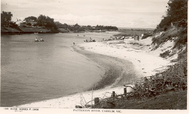
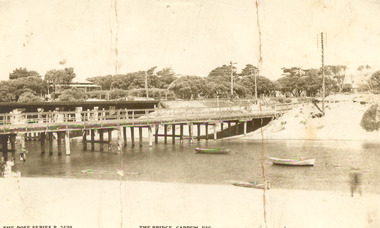
Photograph - Patterson River, Rose Series Postcard
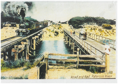
... Patterson River...Patterson River...Black and white photo of Patterson River, looking east from the Patterson River Bridge. ...THE ROSE SERIES P. 2908 - PATTERSON RIVER, CARRUM, VIC...Chelsea & District Historical Society Inc The Chelsea Activity Hub 3-5 Showers Ave Chelsea 3196 melbourne The first bridge over the river was built in the early 1880's, prior to this it was a pontoon bridge. Patterson River Chelsea Patterson River Bridge Carrum Bridge canoes beach leisure The Rose Series THE ROSE SERIES P. 2908 - PATTERSON RIVER, CARRUM, VIC Black and white photo of Patterson River, looking east from the Patterson River Bridge. ...The first bridge over the river was built in the early 1880's, prior to this it was a pontoon bridge.Black and white photo of Patterson River, looking east from the Patterson River Bridge. People in canoes on the river and sitting on the river bank. Houses can be seen on the opposite bank.THE ROSE SERIES P. 2908 - PATTERSON RIVER, CARRUM, VICpatterson river, chelsea, patterson river bridge, carrum bridge, canoes, beach, leisure, the rose series -
 Chelsea & District Historical Society Inc
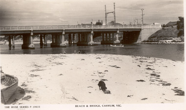
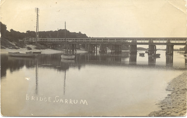
Photograph - Patterson River, Rose Series Postcard
... Patterson River...Patterson River...Black and white photo of Patterson River, looking looking east to the Patterson River Bridge. ...Chelsea & District Historical Society Inc The Chelsea Activity Hub 3-5 Showers Ave Chelsea 3196 melbourne The first bridge over the river was built in the early 1880's, prior to this it was a pontoon bridge. Patterson River Chelsea Patterson River Bridge Carrum Bridge canoes beach leisure The Rose Series THE ROSE SERIES P. 10633 - BEACH AND BRIDGE, CARRUM, VIC Black and white photo of Patterson River, looking looking east to the Patterson River Bridge. ...The first bridge over the river was built in the early 1880's, prior to this it was a pontoon bridge.Black and white photo of Patterson River, looking looking east to the Patterson River Bridge. People in canoes on the river and sitting on the river bank. THE ROSE SERIES P. 10633 - BEACH AND BRIDGE, CARRUM, VICpatterson river, chelsea, patterson river bridge, carrum bridge, canoes, beach, leisure, the rose series -
 Chelsea & District Historical Society Inc
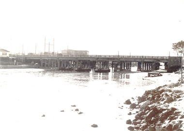
Photograph - Patterson River, Rail and Road Bridge, Carrum
... Patterson River...Patterson River...Black and white photo of Patterson River, looking east from the Port Phillip Bay. ...In 1927 a concrete bridge was built to replace the wooden bridge. Patterson River Chelsea Patterson River Bridge Carrum Bridge canoes beach leisure PATTERSON RRIVER BRIDGE, CARRUM Black and white photo of Patterson River, looking east from the Port Phillip Bay. ...The first bridge over the river was built in the early 1880's, prior to this it was a pontoon bridge. In 1927 a concrete bridge was built to replace the wooden bridge.Black and white photo of Patterson River, looking east from the Port Phillip Bay. PATTERSON RRIVER BRIDGE, CARRUMpatterson river, chelsea, patterson river bridge, carrum bridge, canoes, beach, leisure -
 Chelsea & District Historical Society Inc
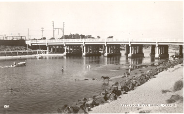
Photograph - Patterson River, Rail and Road Bridge, Carrum
... Patterson River...Patterson River...Black and white photo of Patterson River, taken from Beauty Point, Carrum Victoria. ...In 1927 a concrete bridge was built to replace the wooden bridge. Patterson River Chelsea Patterson River Bridge Carrum Bridge beach leisure Beauty Point boats Black and white photo of Patterson River, taken from Beauty Point, Carrum Victoria. ...The first bridge over the river was built in the early 1880's, prior to this it was a pontoon bridge. In 1927 a concrete bridge was built to replace the wooden bridge.Black and white photo of Patterson River, taken from Beauty Point, Carrum Victoria. patterson river, chelsea, patterson river bridge, carrum bridge, beach, leisure, beauty point, boats -
 Chelsea & District Historical Society Inc
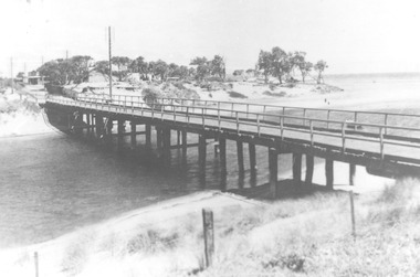
Photograph - Patterson River, Rail and Road Bridge, c 1912
... Patterson River...Patterson River...Sepia photo of the road bridge (Point Nepean / Nepean Highway) and rail bridge, near the mouth of the Patterson River., Carrum ...Chelsea & District Historical Society Inc The Chelsea Activity Hub 3-5 Showers Ave Chelsea 3196 melbourne The first bridge over the river was built in the early 1880's, prior to this it was a pontoon bridge. Patterson River road bridge rail bridge Chelsea transport Patterson River Bridge Carrum Bridge Sepia photo of the road bridge (Point Nepean / Nepean Highway) and rail bridge, near the mouth of the Patterson River., Carrum Rail and Road Bridge Photograph Patterson River ...The first bridge over the river was built in the early 1880's, prior to this it was a pontoon bridge.Sepia photo of the road bridge (Point Nepean / Nepean Highway) and rail bridge, near the mouth of the Patterson River., Carrum patterson river, road bridge, rail bridge, chelsea, transport, patterson river bridge, carrum bridge -
 Chelsea & District Historical Society Inc
Photograph - Patterson River, Rail and Road Bridge, c 1910
... Patterson River...Patterson River...Black and white photo of the wooden road bridge (Point Nepean / Nepean Highway), over Patterson River, Carrum near the mouth of the river. ...Rail and Road Bridge Photograph Patterson River ...The first bridge over the river was built in the early 1880's, prior to this it was a pontoon bridge.Black and white photo of the wooden road bridge (Point Nepean / Nepean Highway), over Patterson River, Carrum near the mouth of the river. patterson river, road bridge, rail bridge, chelsea, transport, patterson river bridge, carrum bridge -
 Chelsea & District Historical Society Inc
Photograph - Patterson River, Rail and Road Bridge
... Patterson River...Patterson River...Black and white photo of the road bridge (Point Nepean / Nepean Highway) and rail bridge, near the mouth of the Patterson River. Taken from the mouth of the river....Rail and Road Bridge Photograph Patterson River ...The first bridge over the river was built in the early 1880's, prior to this it was a pontoon bridge.Black and white photo of the road bridge (Point Nepean / Nepean Highway) and rail bridge, near the mouth of the Patterson River. Taken from the mouth of the river.patterson river, road bridge, rail bridge, chelsea, transport, patterson river bridge, carrum bridge -
 Chelsea & District Historical Society Inc
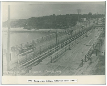
Photograph - Patterson River, Temporary and Old Bridge, c 1927
... Patterson River...Patterson River...Black and white photo of the old wooden road bridge (Point Nepean / Nepean Highway), and a temporary bridge over Patterson River, Carrum near the mouth of the river. ...Temporary and Old Bridge Photograph Patterson River ...The first bridge over the river was built in the early 1880's, prior to this it was a pontoon bridge. In 1927 the construction of a concrete bridge was undertaken.Black and white photo of the old wooden road bridge (Point Nepean / Nepean Highway), and a temporary bridge over Patterson River, Carrum near the mouth of the river. Cars using the old bridge. Rowing boats on shore. Temporary and old bridge, Carrumpatterson river, road bridge, rail bridge, chelsea, transport, patterson river bridge, carrum bridge, temporary bridge, cars -
 Chelsea & District Historical Society Inc
Photograph - Patterson River Postcards, Rail and Road Bridge, c 1905
... Patterson River Postcards...Patterson River...Two postcards of the road bridge (Nepean Highway) with a horse and cart and people crossing and single line rail bridge , with a steam train crossing over Patterson River, near the mouth of the river. One card has been coloured, the other has been modified to advertise Dr Sheldon's Magnetic Liniment....Rail and Road Bridge Photograph Patterson River Postcards ...The first bridge over the river was built in the early 1880's, prior to this it was a pontoon bridge. Dr. Sheldon's Magnetic Liniment was advertised as being able to relieve "at once rheumatism, lumbago, lame back, cuts, bruises or burns, will effect a cure in a remarkably short time. Price 1s 6d and 3s"Two postcards of the road bridge (Nepean Highway) with a horse and cart and people crossing and single line rail bridge , with a steam train crossing over Patterson River, near the mouth of the river. One card has been coloured, the other has been modified to advertise Dr Sheldon's Magnetic Liniment.DR SHELDON'S NEW DISCOVERY 16' & 3' BANISHES ALL PAINS AT CARRUM VICTORIApatterson river, road bridge, rail bridge, dr sheldon's linament, chelsea, steam train, transport, chelsea bridge, patterson bridge -
 Kingston Arts
Painting, Pauline Quinn, Patterson River, 1981
... Patterson River...Kingston Arts 979 Nepean Hwy (Cnr South Road and Nepean Hwy, 100 metres from Moorabbin train station) Moorabbin melbourne Patterson River Painting Pauline Quinn ... -
 Uniting Church Archives - Synod of Victoria
Photograph, 1987
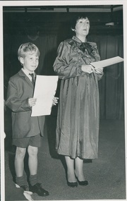
... Anne Hedt was Director of Music at St Leonard's Patterson River campus....B&W photograph showing Thomas Kellett student and Anne Hedt Director of Music at St Leonard's Patterson River campus....Uniting Church Archives - Synod of Victoria 54 Serrell Street Malvern East melbourne Anne Hedt was Director of Music at St Leonard's Patterson River campus. hedt, anne kellett, thomas st leonard's college "Thomas Kellett and Anne Hedt C&N 8/7/1987 page 16" B&W photograph showing Thomas Kellett student and Anne Hedt Director of Music at St Leonard's Patterson River campus. ...Anne Hedt was Director of Music at St Leonard's Patterson River campus.B&W photograph showing Thomas Kellett student and Anne Hedt Director of Music at St Leonard's Patterson River campus."Thomas Kellett and Anne Hedt C&N 8/7/1987 page 16"hedt, anne, kellett, thomas, st leonard's college -
 City of Kingston
Photograph - Colour, 29 January 1993
... ...Patterson River...This 1993 image includes Bonbeach High School prior to demolition, Bonbeach Primary School and Patterson River Golf Club. Sections of Patterson Lakes are not yet developed, including Rhode and Staten Islands. ...This 1993 image includes Bonbeach High School prior to demolition, Bonbeach Primary School and Patterson River Golf Club. Sections of Patterson Lakes are not yet developed, including Rhode and Staten Islands. ...Bonbeach, Carrum and Patterson Lakes are suburbs in the City of Kingston. Bonbeach and Carrum were holiday destinations in early 20th century and over time the housing has converted to permanent residential structures. In Patterson Lakes, the area consists predominantly of newer housing developments and the tidal canal system which is accessible to many dwellings joins Port Phillip Bay.Bonbeach, Carrum and Patterson Lakes were previously part of the extensive Carrum Carrum Swamp. The area was once a source of fish and eels for the Mayone-Bulluk clan of the Bunurong people. Over time the area was drained and this allowed farming at Carrum and Bonbeach, although the area was prone to flooding. In the early 1920s and 30s the land was converted to residential dwellings. In 1973 investigations commenced nearby to Bonbeach and Carrum into the development of a unique residential area comprising canals and waterways. It was originally proposed to be known as "Gladesville". Circa 1974, the area was rezoned from rural to residential and named Patterson Lakes. Development has been continuous since the 1970s with staged construction of the waterways, residential housing, and supporting infrastructure and facilities.Laminated colour aerial photograph of the Bonbeach, Carrum and Patterson Lakes region within City of Kingston. This 1993 image includes Bonbeach High School prior to demolition, Bonbeach Primary School and Patterson River Golf Club. Sections of Patterson Lakes are not yet developed, including Rhode and Staten Islands. Long Island Point appears to be a recent development with many spare blocks and new houses under construction. The Patterson River marina is prominent and the river mouth as it meets Port Phillip Bay. The Carrum railway station is visible.Black type on white adhesive sticker: No. 6661 Black type on white adhesive sticker: 26E/6661, 29/1/93, 4.25 pm Black type on white adhesive sticker 29-1-93 Yellow circular adhesive stickerbonbeach, carrum, patterson lakes, patterson river, carrum carrum swamp, canals and waterways -
City of Kingston
Photograph - Colour, 31 January 1993
... Patterson Lakes is a suburb in the City of Kingston that is built one kilometre upstream of the mouth of the Patterson River. The area is bordered by the Patterson River and Eel Race Drain which enters the Kananook Creek. ...This 1993 image includes Patterson River Secondary College, Roy Dore Reserve, Kananook Creek and Nepean Highway. ...City of Kingston Parkdale Library 96 Parkers Road, Parkdale Parkdale Patterson Lakes is a suburb in the City of Kingston that is built one kilometre upstream of the mouth of the Patterson River. The area is bordered by the Patterson River and Eel Race Drain which enters the Kananook Creek. ...Patterson Lakes is a suburb in the City of Kingston that is built one kilometre upstream of the mouth of the Patterson River. The area is bordered by the Patterson River and Eel Race Drain which enters the Kananook Creek. The suburb consists predominantly of newer housing developments and the tidal canal system of the development joins Port Phillip Bay. Patterson Lakes and the Kananook Creek were previously part of the extensive Carrum Carrum Swamp. The area was once a source of fish and eels for the Mayone-Bulluk clan of the Bunurong people. Over time the area was drained and in 1973 investigations commenced into the development of a unique residential area that would be built adjacent to canals and waterways. It was originally proposed to be known as "Gladesville". The development would give the suburb's homeowners access to Port Phillip Bay "from their back door". Circa 1974, the area was rezoned from rural to residential and named Patterson Lakes. Development has been continuous since the 1970s with construction of residential housing, schools, shopping centres, marinas, a hotel and library.Laminated colour aerial photograph of the Carrum and Patterson Lakes region within City of Kingston. This 1993 image includes Patterson River Secondary College, Roy Dore Reserve, Kananook Creek and Nepean Highway. The railway line can be seen as it veers inland from Eel Race Road, Seaford. The section of Ocean Reef Drive and Palm Beach Drive in Patterson Lakes appears to be a recent development with many spare blocks and new houses under construction.Black typed lettering on white adhesive label: 31.1.93 Black typed lettering on white adhesive label: 27E/7140 31/1/93 12.55 pm Black typed lettering on white label: 7140 Yellow round adhesive label located on left sidepatterson lakes, seaford, kananook creek, carrum carrum swamp, canals and waterways -
City of Kingston
Photograph - Colour, c. 1993
... Patterson Lakes is a suburb in the City of Kingston that is built one kilometre upstream of the mouth of the Patterson River. The area is bordered by the Patterson River and Eel Race Drain which enters the Kananook Creek. ...This 1993 image includes Patterson River Secondary College, Roy Dore Reserve, Kananook Creek and Nepean Highway. ...City of Kingston Parkdale Library 96 Parkers Road, Parkdale Parkdale Patterson Lakes is a suburb in the City of Kingston that is built one kilometre upstream of the mouth of the Patterson River. The area is bordered by the Patterson River and Eel Race Drain which enters the Kananook Creek. ...Patterson Lakes is a suburb in the City of Kingston that is built one kilometre upstream of the mouth of the Patterson River. The area is bordered by the Patterson River and Eel Race Drain which enters the Kananook Creek. The suburb consists predominantly of newer housing developments and the tidal canal system of the development joins Port Phillip Bay.Patterson Lakes and the Kananook Creek were previously part of the extensive Carrum Carrum Swamp. The area was once a source of fish and eels for the Mayone-Bulluk clan of the Bunurong people. Over time the area was drained and in 1973 investigations commenced into the development of a unique residential area that would be built adjacent to canals and waterways. It was originally proposed to be known as "Gladesville". The development would give the suburb's homeowners access to Port Phillip Bay "from their back door". Circa 1974, the area was rezoned from rural to residential and named Patterson Lakes. Development has been continuous since the 1970s with construction of residential housing, schools, shopping centres, marinas, a hotel and library.Laminated colour aerial photograph of the Carrum and Patterson Lakes region within City of Kingston. This 1993 image includes Patterson River Secondary College, Roy Dore Reserve, Kananook Creek and Nepean Highway. The railway line can be seen as it veers inland from Eel Race Road, Seaford. The section of Palm Beach Drive, Curlew Point Drive, Snapper Point Drive, Clipper Island and Myola Street in Patterson Lakes appears to be a recent development with many spare blocks and new houses under construction.patterson lakes, seaford, kananook creek, carrum carrum swamp, canals and waterways -
City of Kingston
Photograph - Colour, 1993
... Carrum is a suburb in the City of Kingston bordered by the Patterson River in the north and Kananook Creek in the south. ...Prominent features include Roy Dore Reserve, Carrum Primary School, Patterson River Secondary College, Keast Park Seaford, the Seaford Swamp Drain and a section of Downs Estate situated on the traditional lands of the Bunurong people....City of Kingston Parkdale Library 96 Parkers Road, Parkdale Parkdale Carrum is a suburb in the City of Kingston bordered by the Patterson River in the north and Kananook Creek in the south. ...Carrum is a suburb in the City of Kingston bordered by the Patterson River in the north and Kananook Creek in the south. To the east the suburb is adjacent to Patterson Lakes. The Carrum Station was opened in 1882, when the railway line from Mordialloc was extended to Frankston. In the early 20th century, it was a destination for holidaymakers occupying tents and cabins. The area now consists of older housing and over time there have been many new housing developments.Carrum is located in the area that was originally part of the Carrum Carrum Swamp. The district had originally been the home of the Bunerong people who fished, gathered food and found refuge in the sand dunes. The Swamp was drained in 1879 when the Patterson Cut was formed and became known as Patterson River. Apart from local farmers, fishermen and hotel-keepers, there were few permanent residents until the early 20th century when it had become popular as a beach resort. In the 1920s and 1930s the area became occupied by more permanent residents.Laminated aerial colour photograph of Carrum and Patterson Lakes in the City of Kingston. The photograph also includes Kananook Creek and the northern section of Seaford. Prominent features include Roy Dore Reserve, Carrum Primary School, Patterson River Secondary College, Keast Park Seaford, the Seaford Swamp Drain and a section of Downs Estate situated on the traditional lands of the Bunurong people.Black type on white adhesive sticker: No. 7140 Black type of white adhesive sticker: 31-1-93 Black handwritten ink (marker): * [an asterisk] Yellow circular adhesive stickerpatterson lakes, seaford, carrum carrum swamp -
 Uniting Church Archives - Synod of Victoria
Photograph
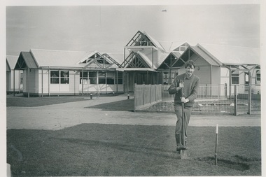
... Caretaker Ross Simpson at Patterson River. Church and Nation 8 July 1987 p.15 ...Caretaker Ross Simpson at Patterson River. Church and Nation 8 July 1987 p.15 Ross Simpson Photograph ...Ross SimpsonCaretaker Ross Simpson at Patterson River. Church and Nation 8 July 1987 p.15 -
 Chelsea & District Historical Society Inc
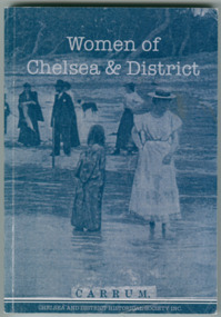
Book - Book. With blue & white cover. No ISBN Printed 2010, Dorothy Meadows OAM et al, Women of Chelsea & District
... Several People paddling in Patterson River. 184 pages. 14. M X 210m....Several People paddling in Patterson River. 184 pages. 14. M X 210m. Women of Chelsea & District Book Book. ...A Tribute to the varied lives of Women of Chelsea & District .Commitee Included. Margaret Diggerson, Val Hambridge, Margaret Jacobs, Dorothy Meadows OAM, Linda Meadows, Shirley Simpson, Leonie Taylor. Limited publication 2010.Only 500 published. Contains localised information about women of Chelsea.Blue & white Cover, Lower Right Corner creased. Several People paddling in Patterson River. 184 pages. 14. M X 210m.Women of Chelsea & Districtchelsea & district historical society inc., book, women, women of chelsea -
City of Kingston
Photograph - Colour, 29 January 1993
... Immediately east of the school sites is the Patterson River Golf Club. The Bonbeach sports reserve has five ovals and is home to the Bonbeach football and baseball clubs. ...The extent of this 1993 aerial image includes: Top left - Maury Road at the south end of the Chelsea shopping Centre; Top right - Scotch Parade Chelsea Bottom left - Monica Avenue in Bonbeach; Bottom right - Patterson River Golf Club. Landmarks include St Joseph's Church and Primary School, Chelsea Primary School, Bonbeach Station, Bonbeach Fotball Club sports playing fields and Bonbeach Life Saving Club. ...Immediately east of the school sites is the Patterson River Golf Club. The Bonbeach sports reserve has five ovals and is home to the Bonbeach football and baseball clubs. ...Bonbeach is a small beachside suburb located between Chelsea and Carrum. The station was opened in 1926 and was the last to be established in the group from Aspendale to Carrum. Urban growth began after World War II. State primary and high schools were opened in 1958 on land in Breeze Street that was once occupied by The Australian Glass Manufacturers. Immediately east of the school sites is the Patterson River Golf Club. The Bonbeach sports reserve has five ovals and is home to the Bonbeach football and baseball clubs. The suburb borders the Edithvale-Seaford Wetlands which is the remnant site of the Carrum Carrum swamp, once the home of the Bunurong people.Bonbeach was originally a seaside destination for holidaymakers and the housing comprised of holiday homes and gradually more permanent residents. It was not until 1926 that Bonbeach had its own railway station. From 1906 until the late 1940s sand was quarried on the east side of the railway line and used in the manufacture of glass. The Australian Glass Manufacturers sold this land in residential blocks and Bonbeach's permanent population spread from the coastal strip across to the other side of the railway line. Laminated colour aerial photograph of the suburb of Bonbeach and also the southern section of neighbouring Chelsea within the City of Kingston. The extent of this 1993 aerial image includes: Top left - Maury Road at the south end of the Chelsea shopping Centre; Top right - Scotch Parade Chelsea Bottom left - Monica Avenue in Bonbeach; Bottom right - Patterson River Golf Club. Landmarks include St Joseph's Church and Primary School, Chelsea Primary School, Bonbeach Station, Bonbeach Fotball Club sports playing fields and Bonbeach Life Saving Club. The Edithvale Wetlands is featured prominently to the right-hand side of the image. Black typed writing on white adhesive label: No. 6662 Black typed writing on white adhesive label: 26E/6662, 29/1/93, 4.25 pm Black typed writing on white adhesive label: 29-1-93 Black typed writing on white adhesive label: P000109 Circular yellow adhesive sticker bonbeach, chelsea -
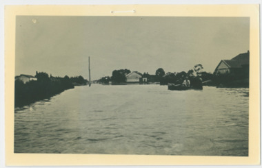
 Chelsea & District Historical Society Inc
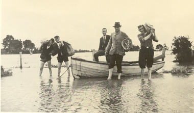
Photograph - Chelsea Flood December 1934, Delivering Food
... In December 1934, 700 houses were inundated with water, when the Dandenong Creek and Patterson River broke their banks....Chelsea & District Historical Society Inc The Chelsea Activity Hub 3-5 Showers Ave Chelsea 3196 melbourne In December 1934, 700 houses were inundated with water, when the Dandenong Creek and Patterson River broke their banks. flood chelsea Dandenong Creek Wells Road Black and white photo of five men in a life boat delivering rations to flood victims, landing at Wells Road. ...In December 1934, 700 houses were inundated with water, when the Dandenong Creek and Patterson River broke their banks.Black and white photo of five men in a life boat delivering rations to flood victims, landing at Wells Road. One of the men is Livock.flood, chelsea, dandenong creek, wells road -
 Chelsea & District Historical Society Inc
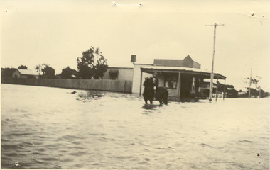
Photograph - Chelsea Flood December 1934, Corner of Sherwood Avenue and Fowler Street
... In December 1934, 700 houses were inundated with water, when the Dandenong Creek and Patterson River broke their banks....Chelsea & District Historical Society Inc The Chelsea Activity Hub 3-5 Showers Ave Chelsea 3196 melbourne In December 1934, 700 houses were inundated with water, when the Dandenong Creek and Patterson River broke their banks. flood chelsea Dandenong Creek Fowler Street Sherwood Avenue Black and white photo of water inundating a shop on the corner of Sherwood Avenue and Fowler Street, Chelsea. ...In December 1934, 700 houses were inundated with water, when the Dandenong Creek and Patterson River broke their banks.Black and white photo of water inundating a shop on the corner of Sherwood Avenue and Fowler Street, Chelsea. A person is on course back riding through the flood waters.flood, chelsea, dandenong creek, fowler street, sherwood avenue -
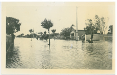
 Chelsea & District Historical Society Inc
Photograph - Chelsea Flood December 1934, Wells Road and Thames Promenade
... In December 1934, 700 houses were inundated with water, when the Dandenong Creek and Patterson River broke their banks....Chelsea & District Historical Society Inc The Chelsea Activity Hub 3-5 Showers Ave Chelsea 3196 melbourne In December 1934, 700 houses were inundated with water, when the Dandenong Creek and Patterson River broke their banks. flood chelsea Dandenong Creek Fowler Street Sherwood Avenue Black and white photo taken from Wells Road looking down Thames Promenade, Chelsea. ...In December 1934, 700 houses were inundated with water, when the Dandenong Creek and Patterson River broke their banks.Black and white photo taken from Wells Road looking down Thames Promenade, Chelsea.flood, chelsea, dandenong creek, fowler street, sherwood avenue -
 Chelsea & District Historical Society Inc
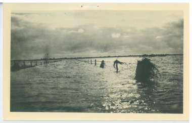
Photograph - Chelsea Flood December 1934, Men in boat delivering supplies
... In December 1934, 700 houses were inundated with water, when the Dandenong Creek and Patterson River broke their banks....Chelsea & District Historical Society Inc The Chelsea Activity Hub 3-5 Showers Ave Chelsea 3196 melbourne In December 1934, 700 houses were inundated with water, when the Dandenong Creek and Patterson River broke their banks. flood chelsea Dandenong Creek Fowler Street Sherwood Avenue Black and white photo of four men in a life boat taking supplies to houses and farms Men in boat delivering supplies Photograph Chelsea Flood December 1934 ...In December 1934, 700 houses were inundated with water, when the Dandenong Creek and Patterson River broke their banks.Black and white photo of four men in a life boat taking supplies to houses and farmsflood, chelsea, dandenong creek, fowler street, sherwood avenue -
 Chelsea & District Historical Society Inc
Photograph - Chelsea Flood December 1934, Argyle Avenue, Chelsea
... In December 1934, 700 houses were inundated with water, when the Dandenong Creek and Patterson River broke their banks....Chelsea & District Historical Society Inc The Chelsea Activity Hub 3-5 Showers Ave Chelsea 3196 melbourne In December 1934, 700 houses were inundated with water, when the Dandenong Creek and Patterson River broke their banks. flood chelsea Dandenong Creek Fowler Street Argyle avenue Horse and Cart Black and white photo boys playing in the flood waters in Argyle Street, Chelsea, East of Fowler Street. ...In December 1934, 700 houses were inundated with water, when the Dandenong Creek and Patterson River broke their banks.Black and white photo boys playing in the flood waters in Argyle Street, Chelsea, East of Fowler Street. Coming down the street is a horse pulling a cart with people on board, and a person on horse back following.flood, chelsea, dandenong creek, fowler street, argyle avenue, horse and cart -
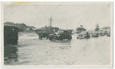 Chelsea & District Historical Society Inc
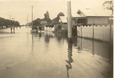
Photograph - Chelsea Flood December 1934, Point Nepean Road (Nepean Highway)
... In December 1934, 700 houses were inundated with water, when the Dandenong Creek and Patterson River broke their banks....Chelsea & District Historical Society Inc The Chelsea Activity Hub 3-5 Showers Ave Chelsea 3196 melbourne In December 1934, 700 houses were inundated with water, when the Dandenong Creek and Patterson River broke their banks. flood chelsea Dandenong Creek Nepean Highway Point Nepean Road Black and white photo of flood waters across Point Nepean Road (now Nepean Highway). ...In December 1934, 700 houses were inundated with water, when the Dandenong Creek and Patterson River broke their banks.Black and white photo of flood waters across Point Nepean Road (now Nepean Highway). Cars and trucks are driving through the water.flood, chelsea, dandenong creek, nepean highway, point nepean road -
 Chelsea & District Historical Society Inc
Photograph - Chelsea Flood December 1934, Wells Road, Chelsea
... In December 1934, 700 houses were inundated with water, when the Dandenong Creek and Patterson River broke their banks....Chelsea & District Historical Society Inc The Chelsea Activity Hub 3-5 Showers Ave Chelsea 3196 melbourne In December 1934, 700 houses were inundated with water, when the Dandenong Creek and Patterson River broke their banks. flood chelsea Dandenong Creek Nepean Highway Point Nepean Road Three Black and white photo of flood waters across Wells Road, Chelsea. ...In December 1934, 700 houses were inundated with water, when the Dandenong Creek and Patterson River broke their banks.Three Black and white photo of flood waters across Wells Road, Chelsea. A SEC truck can be see travelling down Wells Road in photo one and two, with people viewing the flooded street.flood, chelsea, dandenong creek, nepean highway, point nepean road -
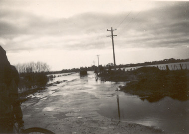
 Chelsea & District Historical Society Inc
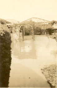
Photograph - Chelsea Flood December 1934, Carrum Hotel, Nepean Highway
... In December 1934, 700 houses were inundated with water, when the Dandenong Creek and Patterson River broke their banks....Chelsea & District Historical Society Inc The Chelsea Activity Hub 3-5 Showers Ave Chelsea 3196 melbourne In December 1934, 700 houses were inundated with water, when the Dandenong Creek and Patterson River broke their banks. flood chelsea Dandenong Creek Nepean Highway Point Nepean Road Carrum Hotel Black and white photo of flood waters in the garden of Carrum Hotel, showing an archway and in the background is a partially built building. ...In December 1934, 700 houses were inundated with water, when the Dandenong Creek and Patterson River broke their banks.Black and white photo of flood waters in the garden of Carrum Hotel, showing an archway and in the background is a partially built building.flood, chelsea, dandenong creek, nepean highway, point nepean road, carrum hotel -
 Chelsea & District Historical Society Inc
Photograph - Chelsea Flood December 1934
... In December 1934, 700 houses were inundated with water, when the Dandenong Creek and Patterson River broke their banks....Chelsea & District Historical Society Inc The Chelsea Activity Hub 3-5 Showers Ave Chelsea 3196 melbourne In December 1934, 700 houses were inundated with water, when the Dandenong Creek and Patterson River broke their banks. flood chelsea Dandenong Creek Nepean Highway Point Nepean Road Two Black and white photo of flood waters in Chelsea. ...In December 1934, 700 houses were inundated with water, when the Dandenong Creek and Patterson River broke their banks.Two Black and white photo of flood waters in Chelsea. flood, chelsea, dandenong creek, nepean highway, point nepean road -
 Charlton Golden Grains Museum Inc
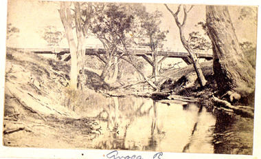
Photograph, Avoca River
... Patterson...Avoca River...Photo handed through the family of James Patterson (builder) of the first bridge accross the Avoca River at Charlton....Grace Cadgow James Patterson Avoca River James Patterson Bridge Photo handed through the family of James Patterson (builder) of the first bridge accross the Avoca River at Charlton. ...Landscape Sepia Photograph UnfamedPhoto handed through the family of James Patterson (builder) of the first bridge accross the Avoca River at Charlton.grace cadgow james patterson, avoca river, james patterson bridge -
 Charlton Golden Grains Museum Inc
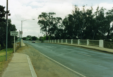
Photograph, James Patterson Bridge
... James Patterson Bridge...Avoca River...James Patterson Bridge Avoca River Calder Highway Bridge accross Avoca River Charlton Vic. 3525 Landscape Coloured Photograph James Patterson Bridge Photograph ...Landscape Coloured Photographjames patterson bridge, avoca river, calder highway bridge accross avoca river charlton vic. 3525 -
 Chelsea & District Historical Society Inc
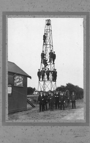
Photograph - Chelsea Fire Brigade, Members of the Chelsea Fire Brigade standing in front of the of the Fire station, on the bell and the hose tower, c 1920
... In March 2006, the brigade amalgamated with the Carrum Fire Brigade to form the Patterson River Fire Brigade. ...In March 2006, the brigade amalgamated with the Carrum Fire Brigade to form the Patterson River Fire Brigade. Firefighters Chelsea Chelsea Fire Brigade Fireman fire equipment Black and White photo of the members of the Chelsea Fire Brigade, standing in front of the station which was situated on Point Nepean Road. ...The Chelsea Fire Brigade in Victoria, Australia, began as a volunteer unit around 1912 to serve the growing beachside suburb. Officially registered with the Country Fire Brigades Board in 1925, the brigade was a vital community service for decades. In March 2006, the brigade amalgamated with the Carrum Fire Brigade to form the Patterson River Fire Brigade. Black and White photo of the members of the Chelsea Fire Brigade, standing in front of the station which was situated on Point Nepean Road. Four members Have been identified: Standing on ground from the right, Captain J. J. Smith, Frank Jennings, Mr Frickie, Zeke Smith.firefighters, chelsea, chelsea fire brigade, fireman, fire equipment