Showing 59 items matching "pine avenue"
-
 Greensborough Historical Society
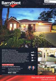
Advertising Leaflet, 9 Pine Avenue Briar Hill, 07/11/2012
... 9 Pine Avenue Briar Hill...pine avenue briar hill...9 Pine Avenue Briar Hill. 3 bedroom home, private sale, sold 7 November 2012 for $515,000...Greensborough Historical Society 34A Glenauburn Road Lower Plenty Lower Plenty melbourne 9 Pine Avenue Briar Hill. 3 bedroom home, private sale, sold 7 November 2012 for $515,000 pine avenue briar hill Real estate advertising leaflet, 1 sheet, printed in colour both sides 9 Pine Avenue Briar Hill Advertising Leaflet Barry Plant Eltham ...9 Pine Avenue Briar Hill. 3 bedroom home, private sale, sold 7 November 2012 for $515,000Real estate advertising leaflet, 1 sheet, printed in colour both sidespine avenue briar hill -
 Camberwell Historical Society
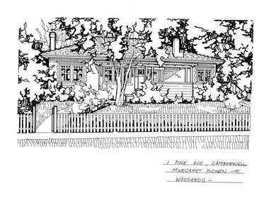
Drawing (series) - Architectural drawing, 1 Pine Avenue, Camberwell, 1991
... 1 Pine Avenue, Camberwell...Pen and ink architectural drawing on drafting film of 1 Pine Avenue, Camberwell by Margaret Picken...The fact that each drawing is dated with the year it was created also proves a valuable record for house historians - since that date a number of the depicted properties have either been altered or demolished. artist architectural drawings margaret picken camberwell houses 1 PINE AVE., CAMBERWELL / MARGARET PICKEN - 91 / WOODARDS Pen and ink architectural drawing on drafting film of 1 Pine Avenue, Camberwell by Margaret Picken 1 Pine Avenue, Camberwell Drawing Architectural drawing ...artist, architectural drawings, margaret picken, camberwell, housesartist, architectural drawings, margaret picken, camberwell, houses -
 Camberwell Historical Society
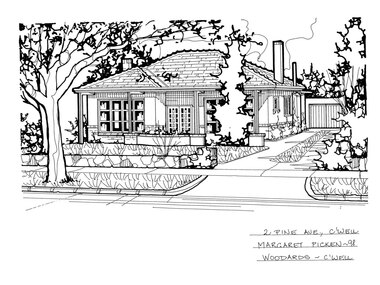
Drawing (series) - Architectural drawing, 2 Pine Avenue, Camberwell, 1998
... 2 Pine Avenue, Camberwell...Pen and ink architectural drawing on drafting film of 2 Pine Avenue, Camberwell by Margaret Picken...The fact that each drawing is dated with the year it was created also proves a valuable record for house historians - since that date a number of the depicted properties have either been altered or demolished. artist architectural drawings margaret picken camberwell houses 2 PINE AVE., C'WELL / MARGARET PICKEN - 98 / WOODARDS - C'WELL Pen and ink architectural drawing on drafting film of 2 Pine Avenue, Camberwell by Margaret Picken 2 Pine Avenue, Camberwell Drawing Architectural drawing ...artist, architectural drawings, margaret picken, camberwell, housesartist, architectural drawings, margaret picken, camberwell, houses -
 Camberwell Historical Society
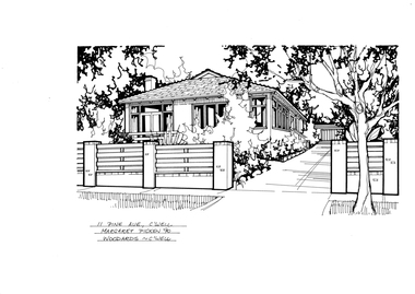
Drawing (series) - Architectural drawing, 11 Pine Avenue, Camberwell, 1990
... 11 Pine Avenue, Camberwell...Pen and ink architectural drawing on drafting film of 11 Pine Avenue, Camberwell by Margaret Picken...The fact that each drawing is dated with the year it was created also proves a valuable record for house historians - since that date a number of the depicted properties have either been altered or demolished. artist architectural drawings margaret picken camberwell houses 11 PINE AVE., C'WELL / MARGARET PICKEN '90 / WOODARDS - C'WELL Pen and ink architectural drawing on drafting film of 11 Pine Avenue, Camberwell by Margaret Picken 11 Pine Avenue, Camberwell Drawing Architectural drawing ...artist, architectural drawings, margaret picken, camberwell, housesartist, architectural drawings, margaret picken, camberwell, houses -
 Camberwell Historical Society
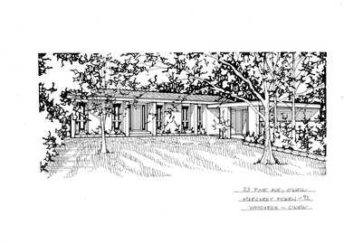
Drawing (series) - Architectural drawing, 23 Pine Avenue, Camberwell, 1992
... 23 Pine Avenue, Camberwell...Pen and ink architectural drawing on drafting film of 23 Pine Avenue, Camberwell by Margaret Picken...The fact that each drawing is dated with the year it was created also proves a valuable record for house historians - since that date a number of the depicted properties have either been altered or demolished. artist architectural drawings margaret picken camberwell houses 23 PINE AVE., C'WELL / MARGARET PICKEN - 92 / WOODARDS - C'WELL Pen and ink architectural drawing on drafting film of 23 Pine Avenue, Camberwell by Margaret Picken 23 Pine Avenue, Camberwell Drawing Architectural drawing ...artist, architectural drawings, margaret picken, camberwell, housesartist, architectural drawings, margaret picken, camberwell, houses -
 Camberwell Historical Society
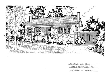
Drawing (series) - Architectural drawing, 34 Pine Avenue, Camberwell, 1992
... 34 Pine Avenue, Camberwell...Pen and ink architectural drawing on drafting film of 34 Pine Avenue, Camberwell by Margaret Picken...The fact that each drawing is dated with the year it was created also proves a valuable record for house historians - since that date a number of the depicted properties have either been altered or demolished. artist architectural drawings margaret picken camberwell houses 34 PINE AVE., C'WELL / MARGARET PICKEN - 92 / WOODARDS - BALWYN Pen and ink architectural drawing on drafting film of 34 Pine Avenue, Camberwell by Margaret Picken 34 Pine Avenue, Camberwell Drawing Architectural drawing ...artist, architectural drawings, margaret picken, camberwell, housesartist, architectural drawings, margaret picken, camberwell, houses -
 Rutherglen Historical Society
Image, Greetings from Rutherglen, 1910 to 1912
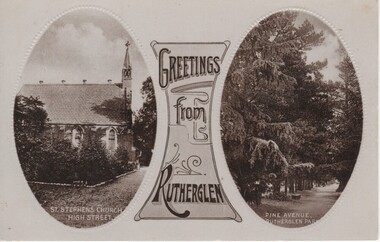
... ...pine avenue...At bottom of right photograph: "Pine Avenue. Rutherglen Park."...Rutherglen Historical Society Murray Street Rutherglen high-country st stephens church rutherglen park high street pine avenue At bottom of left photograph: "St Stephen's Church. ...Black and white postcard with two oval photographs with "Greetings from Rutherglen" on a decorative panel between them. The left photograph is of a church. The right one is of pine trees in Rutherglen Park.At bottom of left photograph: "St Stephen's Church. High Street." At bottom of right photograph: "Pine Avenue. Rutherglen Park."st stephens church, rutherglen park, high street, pine avenue -
 University of Melbourne, Burnley Campus Archives
Photograph - Sepia print, A.E. Bennett, Entrance Gates, 1894-1990
... ...pine tree avenue...I have seen a plan which showed an attractive avenue of trees (pine) from the western end of the property (where the Stockman's Cottage was later sited.)"...I have seen a plan which showed an attractive avenue of trees (pine) from the western end of the property (where the Stockman's Cottage was later sited.)" entrance gates prize essays alfred e. bennett curator's residence pavilion stockman's cottage pine tree avenue 2 copies sepia photograph. ...Note by E.B. Littlejohn, "Is the roadway the original Swan Street? Entrance gates to Gardens in the distance. Roadway leading to the Pavilion hidden behind the trees. No elms showing along the roadway," and by T.H. Kneen, "The roadway appears to terminate at the gates outside the Curator's Residence, sweeping past the Pavilion on the right. I have seen a plan which showed an attractive avenue of trees (pine) from the western end of the property (where the Stockman's Cottage was later sited.)" 2 copies sepia photograph. Copy of sepia photograph of the roadway to the Entrance Gates and Curator's Cottage seen in the distance, with the Pavilion on the right, in, "Prize Essays," Alfred E. Bennett, c.1894, after p 116. Pinus radiata avenue on each side of the road.entrance gates, prize essays, alfred e. bennett, curator's residence, pavilion, stockman's cottage, pine tree avenue -
 Eltham District Historical Society Inc
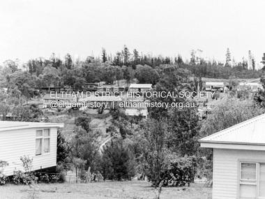
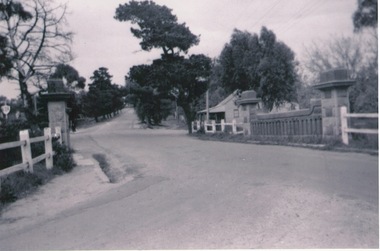
Photograph, Barry Philp, Looking north from Main Road to Storey Avenue, Research, c.1969
... Pine trees...Storey Avenue...Taken from Main Road looking north to the houses in Storey Avenue and the Maroondah Aqueduct. From the appearance of the pine trees along the aqueduct it was taken just after the 1968-1969 fire....Research (Vic.) bushfires Main Road Maroondah Aqueduct Pine trees Storey Avenue Victorian Bushfires - 1969 Digital copy only Looking north from Main Road to Storey Avenue, Research Photograph Photograph Barry Philp ...Taken from Main Road looking north to the houses in Storey Avenue and the Maroondah Aqueduct. From the appearance of the pine trees along the aqueduct it was taken just after the 1968-1969 fire.research (vic.), bushfires, main road, maroondah aqueduct, pine trees, storey avenue, victorian bushfires - 1969 -
 Phillip Island and District Historical Society Inc.
Photograph, 1960
... Black & White photograph of shop buildings with Baker's shop on corner of Chapel Street & thompson Avenue. Pine trees and buildings beside and in the background....Phillip Island and District Historical Society Inc. phillip-island-and-the-bass-coast Donated by Jack Jenner phillip island bakery cowes shop buildings phillip island jack jenner On back: "About 1960" Black & White photograph of shop buildings with Baker's shop on corner of Chapel Street & thompson Avenue. Pine trees and buildings beside and in the background. ...Donated by Jack JennerBlack & White photograph of shop buildings with Baker's shop on corner of Chapel Street & thompson Avenue. Pine trees and buildings beside and in the background.On back: "About 1960"phillip island bakery, cowes shop buildings, phillip island, jack jenner -
 Hume City Civic Collection
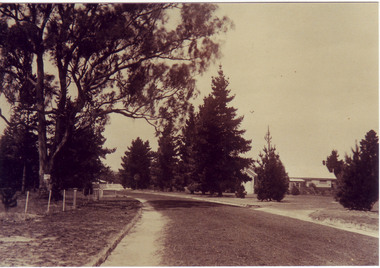
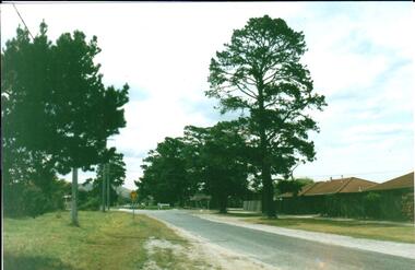
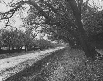
Photograph, Early 1980's
... A coloured photograph of Cornish Street, looking west taken from Horne Street, with an avenue of pine trees on either side of the road. ...Hume City Civic Collection 44 Macedon Street Sunbury melbourne cornish street horne street mt. holden george evans collection A coloured photograph of Cornish Street, looking west taken from Horne Street, with an avenue of pine trees on either side of the road. ...A coloured photograph of Cornish Street, looking west taken from Horne Street, with an avenue of pine trees on either side of the road. There is a roundabout at the first intersection and Mt. Holden can be seen in the distance.cornish street, horne street, mt. holden, george evans collection -
 Phillip Island and District Historical Society Inc.
Photograph, 23/04/1925
... Photographs taken by Jessie "girlie" Smith of San Remo who owned The Penguin Cafe in Thompson Avenue. Norfolk Pine believed to have been planted by Baron Ferdinand von Mueller approx. 1863....Phillip Island and District Historical Society Inc. phillip-island-and-the-bass-coast Photographs taken by Jessie "girlie" Smith of San Remo who owned The Penguin Cafe in Thompson Avenue. Norfolk Pine believed to have been planted by Baron Ferdinand von Mueller approx. 1863. phillip island isle of wight hotel fire jessie smith norfolk pine baron ferdinand von mueller Post Card Two black & white photographs of the scene during fire at Isle of wight Hotel 23/4/1925. ...Photographs taken by Jessie "girlie" Smith of San Remo who owned The Penguin Cafe in Thompson Avenue. Norfolk Pine believed to have been planted by Baron Ferdinand von Mueller approx. 1863.Two black & white photographs of the scene during fire at Isle of wight Hotel 23/4/1925. Gateways left and right. Norfolk Pine in the centre. Smoke billowing behind.Post Cardphillip island, isle of wight hotel fire, jessie smith, norfolk pine, baron ferdinand von mueller -
 Sunbury Family History and Heritage Society Inc.
Photograph, Rosa McCall, Old Broadmeadows Township, 1949
... A small building with a pitched roof and a verandah is on the RHS of the image and the road leading out of the town is bordered with an avenue of pine trees....A small building with a pitched roof and a verandah is on the RHS of the image and the road leading out of the town is bordered with an avenue of pine trees. Old Broadmeadows Township Photograph Rosa McCall ...The small town in the photograph is the former Broadmeadows Township (now part of Westmeadows). It was situated on the Old Sydney Road (Mickleham Road) and 2 miles east of the Broadmeadows Station. The stone bridge in the foreground spans the Moonee Ponds Creek and Fawkner Street is the road, which leads southwards to Gladstone Park and Tullamarine. The little building was a lolly shop that Mrs. Ethel Mitchell owned and ran for many years.Until 1869, before Sydney Road was finally opened, travellers on their way to Sydney would pass through the Broadmeadows Township.A copy of a non-digital black and white photograph of a road way with a bridge in the foreground leading to a small settlement. A small building with a pitched roof and a verandah is on the RHS of the image and the road leading out of the town is bordered with an avenue of pine trees.old broadmeadows township, fawkner street, moonee ponds creek, westmeadows, bridges -
 Bendigo Historical Society Inc.
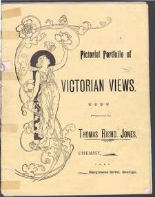
Document - PICTORIAL PORTFOLIO OF VICTORIAN VIEWS
... 'On the Campaspe, near Bendigo. View No 8 The Pine Avenue, Rosalind Park. View No 9. Scenes on Lake Wendouree, Ballarat. ...'On the Campaspe, near Bendigo. View No 8 The Pine Avenue, Rosalind Park. View No 9. Scenes on Lake Wendouree, Ballarat. ...Yellow covered nine page booklet containing 19th Century views of Bendigo and Ballarat presented by Thomas Richard Jones, Chemist of Hargreaves Street Bendigo. Art Noveau figure of woman on front cover. Inside cover features T R Jones Dispensing Chemist and Druggist printed beside man holding a horse. List of Veterinary products supplied by Jones. Farmer's requisites included Strychnine, Toxa, Phosphorus, Poisoined wheat, Bi-sulphide of Carbon. Egg preserving fluid and milk preserving powder Rennet and butter colouring along with Drenches and Cattle medicenes supplied. View No1. Moorabel Falls Ballarat. View No 2. Statues of Leda and Spring Ballarat. View No 3. A Giant Palm Bendigo. View No 4. View from St Paul's Bendigo. View No 5. Unveiling 'The first Public Statue' Bendigo P/Office in background. View No 6. Statue Presented to the City of Bendigo by Cr Harkness. [Reclining greek beside dog fighting lion] View No 7. 'On the Campaspe, near Bendigo. View No 8 The Pine Avenue, Rosalind Park. View No 9. Scenes on Lake Wendouree, Ballarat. View No 10. Statuary in The Botanical Gardens Ballarat. View No 11. Statues of Burns & Moore Ballarat. View No 12. Botanical Gardens, Ballarat. Inside back cover features list of T R Jones products. Outside back cover features advertisement for T R Jones Universal Corn Cure, and Jone's Compound Pectoral Balm.Printed by Periodicacls Publishing Co, 21 Elizabeth Street Melbourne.bendigo, parks and gardens, bendigo chemist and local views. -
 Eltham District Historical Society Inc
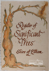
Work on paper - Folio, Register of Significant Trees, Shire of Eltham, c.1993
... Plantanas acerifolia (Plane tree) A number of trees forming the Avenue of Honour to Eltham's First World War soldiers along Main Road between Dalton and Pitt Streets, Eltham. 5. Pinus canariensis (Canary Island Pine), Pinus pinea, (Stone pine) and Cedras altlantica, (Cedar) These trees are located at the Hurst family graves in the grounds of the Hurstbridge Pre-school Centre. ...Plantanas acerifolia (Plane tree) A number of trees forming the Avenue of Honour to Eltham's First World War soldiers along Main Road between Dalton and Pitt Streets, Eltham. 5. Pinus canariensis (Canary Island Pine), Pinus pinea, (Stone pine) and Cedras altlantica, (Cedar) These trees are located at the Hurst family graves in the grounds of the Hurstbridge Pre-school Centre. ...In 1983, the National Trust advised the Shire of Eltham that it was investigating a number of trees within the shire which had been nominated for recording the Register of Significant Trees of Victoria. The trees involved were described in the Shire of Eltham Historical Society Newsletter No. 29, March 1983 as follows:- 1. Eucalyptus melliadora (Yellow box) . a) An outstanding mature specimen 42 metres high in Laughing Waters Road, Eltham. b) Another mature specimen in Arthurs Creek road, Hurstbridge is reported to be the tree under which the bushranger Robert Bourke was tied after he shot and killed Henry Hurst in 1866 . 2. Quercus robur (English Oak). a) "Donaldson's Oak", Donaldsons Road, Kangaroo Ground was planted by John Donaldson from seed collected from Windsor Great Park in 1878. b) "Wippells Oak". This now misshapen tree is located on the St. Andrews Road near the Kangaroo Ground Fire Station. Its origins may have been similar to Donaldson's Oak, and as a young tree it apparently slipped from higher up the hill during wet weather. Both oaks are of local historical importance. 3. Eucalyptus globulus (Blue Gum). A large mature specimen at the corner of the Kangaroo Ground-St. Andrews Road and Bakehouse Road, Panton Hill. 4. Plantanas acerifolia (Plane tree) A number of trees forming the Avenue of Honour to Eltham's First World War soldiers along Main Road between Dalton and Pitt Streets, Eltham. 5. Pinus canariensis (Canary Island Pine), Pinus pinea, (Stone pine) and Cedras altlantica, (Cedar) These trees are located at the Hurst family graves in the grounds of the Hurstbridge Pre-school Centre. In 1991 the Shire of Eltham introduced controls into its planning scheme to protect sites of architectural, historic or conservation interest and significant trees. The controls were approved by the Minister for Planning and Housing. As advised in the Shire of Eltham Historical Society Newsletter No. 78, May 1991, a planning permit is required to demolish or alter any listed building or to destroy, lop or remove any listed tree. Provision is made for comments to be obtained from the National Trust or Historic Buildings Council in considering any applications. The buildings and trees listed were: Buildings: 250 Bolton Street Eltham (former Walter Withers home) "Rosehill" - Bonds Road Lower Plenty St Andrews Church of England - St Andrews "Montsalvat" - Hillcrest Avenue Eltham St Margarets Church and former vicarage - Pitt Street Eltham Presbyterian Church - Kangaroo Ground Parks and Environment Office (former police quarters) Main Road Eltham Former Court House - Main Road Eltham "Shillinglaw Cottage" - Main Road Eltham "The Robins" - Kangaroo Ground Road Warrandyte Trees: "Donaldsons Oak" - Donaldsons Road Kangaroo Ground Yellow Box - Laughing Waters Road Eltham Yellow Box - Arthurs Creek Road Hurstbridge Wippells Oak - St Andrews Road Kanqaroo Road Pines and Cedar - Hurst family cemetery Greysharps Road Hurstbridge Yellow Box - Parsons Road Eltham A large Blue Gum at Panton Hill has been listed but has recently died (1991). In 1993 work by Council Parks and Environment staff and volunteers resulted in the preparation of a Significant Tree Register listing forty-one trees or groups of trees. According to Shire of Eltham Historical Society Newsletter No. 91, March 1993, a similar number remained to be assessed for inclusion in the register. There is a wide range of indigenous and planted trees on private and public land and extending through the Shire of Eltham from Lower Plenty to Kinglake. Most can be viewed from publicly accessible locations. The Significant Tree Register lists 41 trees or groups of trees throughout the Shire. It contains a wide range of naturally occurring and planted trees. They have been assessed according to eleven criteria including size, age, rarity, historical value and the like. The list includes large old Red Gums at Lower Plenty, historic Oaks at Kangaroo Ground and Mountain Ash at Kinglake. The register includes a set of slides showing each tree. Garry Bartlett of the Council's Parks and Environment Section and Faye Shepherd were extensively involved in establishment of the register (Newsletter No. 93, November 1993). In 1999 Niliumbik planners prepared an amendment to the Planning Scheme to provide protection for approximately 200 of the places listed in the heritage studies and also in the Significant Tree Register commenced by the Eltham Council (Eltham District Historical Society Newsletter No. 127, July 1999. In 2004, The Register of Significant Trees was presented to the Eltham District Historical Society by Nillumbik Shire Council as part of a wider collection of of its memorabilia of the former Eltham Shire Council (EDHS Newsletter No. 159, July 2004. Album of loose handmade paper sheets contained within a handmade slip cover constructed of handcrafted card with encapsulated flora material (flowers, vines, ferns) and tinted. Each page also contains an embedded/adhered fern leaf also tinted with lacqueur or similar, text as appropriate in ink by hand calligraphy. Each page also has a white protective sheet cut to size and adhered to back surface with sticky tape and folded over face of page. Pages variously have photographs and coloured masks adhered with a gum resin. Over time much of this resin has let go and photos/masks have been reattached using acid free archival safe adhesive. 15 pages 41 x 29 cm inclusive of 3 blank pages. Slip case 42 x 30 x 1 cm; face cover of slip case has broken off at left hand margin as insufficient depth/flexibility for contents.arthurs creek road, blue gum (eucalyptus globulus), canary island pine (pinus canariensis), couties road, donaldsons oak, donaldsons road, eltham, english oak (quercus robur), eucalyptus melliodora, graysharps road, hurst tree, hurstbridge, ironbark (eucalyptus tricarpa), ironbark hill, kangaroo ground, kangaroo ground-kinglake road, laughing waters road, panton hill hotel, panton hill, parsons road, significant trees register, sonia van bodegraven, sonjart, stone pine (pinus pinea). atlantic cedar (cedrus atlantica), wippells oak, yellow box gum (eucalyptus melliodora), yellow box gum -
 Glen Eira Historical Society
Article - MCKINNON
... Avenue... Ormond Theatre... Theatres... Lester Harry... The Plaza... Railway Crossing... Railway Gates... Wright Street... Nichols L.... Builders... Pine...White Horrie Robinson’s McInnerney’s Flower Shop Jean Darling’s Cakes Wyles Jim McKinnon Progress Association Glen Orme Avenue Ormond Theatre Theatres Lester Harry The Plaza Railway Crossing Railway Gates Wright Street Nichols L. Builders Pine ...Brief typed history of McKinnon settlement taken from Moorabbin A Pictorial History 1862-1994 by John Cribben. Includes photocopied pages of railway gates, five land estate flyers and an article from the McKinnon Progress, undated.mckinnon, cribben john, crop production, markets, farmers, elster creek, mcmillan archibald, thomas street, centre road, wheatley road, vineyards, south road, ormond, brighton, moorabbin, irish, immigrants, bentleigh, priests, hanrahan pierce, hanrahan johanna, caroll michael, caroll catherine, howes eliza, howes john, howes edward, shanahan denis, shanahan ellen, gould james, gould catherine, howes george, bignell road, jasper road, tucker road, mcguiness family, quinn family, halinan family, malane family, inns, the gardeners arms, mckinnon hotel, bent james, bent thomas, tickets of leave, murray road, were nicholas, sargood family, ripponlea, mansions, elsternwick, st. stephens’ common school, church of england, school houses, evelyn street, st. john’s anglican church, telegraph offices, post offices, state schools, manchester road, north road, nicholls buildings, rivers frank, rivers ray, shops, pridgeon mr., elm grove, sobrin mr., clark misses, greaves bakery, armitage mrs., rout mr., tunnicliffe mrs., lance’s milk bar, johnson’s hardware shop, stiringer mrs., white horrie, robinson’s, mcinnerney’s flower shop, jean darling’s cakes, wyles jim, mckinnon progress association, glen orme avenue, ormond theatre, theatres, lester harry, the plaza, railway crossing, railway gates, wright street, nichols l., builders, pine grove, halls, st. elmo estate, patterson station estate, patterson road, brewer road, purton road, clee hill estate, railway park, hawthorn grove, wattle grove, elm grove, learys estate, manchester road, selkirk avenue, masters estate, lancaster street, moylan street, moorabbin railway crossing -
 Glen Eira Historical Society
Photograph, Beauville Avenue, 34, Murrumbeena, 2001
... Well-established garden including 2 matching pencil pines. Beauville Avenue, 34, Murrumbeena Photograph Photograph ...Originally labelled "Beauville Estate, Established 1936, Still Thriving 65 years on, 10th March 2001", the Beauville Estate Album contains colour photographs of houses in the Estate. They were taken around the time of the Beauville Estate’s 65th Heritage Celebration held on 10/03/2001 and donated to the Caulfield Historical Society shortly afterwards. Photographer unknown.City of Glen Eira’s Heritage Management Plan Vol 2 p79 (this is p84 of the pdf version) – HO12 Beauville Estate and environs, Murrumbeena: The Beauville Historic Area is important at the State level as the first large housing estate undertaken by the AV Jennings Construction Co, later Jennings Group Limited, Victoria’s largest home builder. It is important also as a very early estate development incorporating a range of features other than houses and including made roads, shops and recreation facilities. In this respect it was the forerunner of the comprehensively planned housing estate of the post war era. The estate is distinguished by its aesthetic values, as is the earlier and comparable Hillcrest Estate, which are formed by a combination of restrained diversity in house styles, with the exception of no. 30 in the emerging International style, and by a landscaped garden environment. Colour photograph of white rendered, corner house with unpainted variegated brown brick features. Other features include a wide arched porch, tiled roof, tall brick chimney, cast iron work black porch door, window awnings and low unpainted matching brick fence in the foreground with "34" on the white metal letterbox on top of the right brick pillar beside the concrete pathway leading to the porch. Well-established garden including 2 matching pencil pines.murrumbeena, houses, beauville avenue, architectural styles, 1930's, inter war style, a.v. jennings, av jennings, jennings, brick houses, beauville estate, porches, sir albert victor jennings, a v jennings construction co, beauville estate heritage area, glen eira city council, architectural features, jennings group limited, land subdivision, gardens, beauville historic area, rendered houses, corner houses, brick features, awnings, brick fences, metal letterboxes, trees, cast iron work door -
Glen Eira Historical Society
Document - Glen Orme Avenue, 2, McKinnon
... Avenue... McKinnon... Pine...Landells Rosalind Bick David Railway Park Glen Orme Avenue Glenorme Avenue McKinnon Pine Grove Pinegrove Elster Creek Murray Road Baker Samuel Baker F J Morris J R Dewhurst Edward Y Jamrich B Dendy Henry Were J B Bullock Hilary Document Glen Orme Avenue, 2, McKinnon ...A one page typed research note by Rosalind Landells of the Brighton Historical Society regarding 2 Glen Orme Avenue / Pinegrove, McKinnon, dated 10/07/1991. The note lists the previous owners of the property and gives a brief history of the land. The file also includes one page of handwritten, undated and unattributed working notes.landells rosalind, bick david, railway park, glen orme avenue, glenorme avenue, mckinnon, pine grove, pinegrove, elster creek, murray road, baker samuel, baker f j, morris j r, dewhurst edward y, jamrich b, dendy henry, were j b, bullock hilary -
Glen Eira Historical Society
Article - Glen Eira Parks and Gardens
... Pine... Princes Park... Packer Park... Duncan McKinnon Reserve... King George Reserve... Caulfield Park... Glenhuntly Park... Glen Huntly Park... Bentleigh Reserve... Victory Park... Schools... Education Establishments... Recycling... Water disposal... Cultural Structures... Cultural Establishments... Caulfield RSL... Johnson Carl... War Memorials... Monuments... Memorials... Avenue...Aloysius College Band Rotundas Entertainment Structures Musical Ensembles City of Glen Eira Band Bands The Friends of Caulfield Park Gallipoli Lone Pine Princes Park Packer Park Duncan McKinnon Reserve King George Reserve Caulfield Park Glenhuntly Park Glen Huntly Park Bentleigh Reserve Victory Park Schools Education Establishments Recycling Water disposal Cultural Structures Cultural Establishments Caulfield RSL Johnson Carl War Memorials Monuments Memorials Avenue of Honour “Lone Pine” Glen Eira Leader Glen Eira News Caulfield/Port Phillip Leader Glen Eira Leader Article Glen Eira Parks and Gardens ...This file contains four items. 1/ An article in the Glen Eira News reporting on a new park with indigenous planting and an interpretive walk being developed to link Duncan McKinnon Reserve and Packer Park in Murrumbeena, dated September 2000. 2/ An article from the Glen Eira Leader on the converting of sports grounds from cool season to warm season grasses, as well as the installation of subsurface drip irrigation at Princes Park, Caulfield South, dated March 2012. 3/ An article from the Caulfield/Port Phillip leader reporting Caulfield RSL military historian Carl Johnson’s appeal to have a “lone pine” in Caulfield Park designated as a war memorial, dated 11/9/2012 4/ An article from the Glen Eira/Port Phillip Leader reporting on the Friends of Caulfield Park organising the first band stand concert in over twenty years with the City of Glen Eira Band, dated 6/11/2012glen eira council, hawthorn rd caulfield, glen eira rd caulfield, glen eira, caulfield, parks, reserves, leila rd caulfield, glen eira city council, landscaping, memorial park, kooyong rd caulfield north, caulfield recreation tennis club, murrumbeena rd caulfield, churchill green housing estate, north rd caulfield, boake street caulfield, exservices organisation, rsl clubs, sporting clubs, recreations, sportsgrounds, clubs, tennis clubs, associations, leisure, cultural events, cultural activities, sports establishments, recreations establishments, irrigation, water conservation, conservation of natural resources, water supply, ovals, playing fields, tennis courts, murrumbeena park, school concerts, musical activities, musical events, glen eira artists society, dimarco lisa, st. aloysius college, band rotundas, entertainment structures, musical ensembles, city of glen eira band, bands, the friends of caulfield park, gallipoli lone pine, princes park, packer park, duncan mckinnon reserve, king george reserve, caulfield park, glenhuntly park, glen huntly park, bentleigh reserve, victory park, schools, education establishments, recycling, water disposal, cultural structures, cultural establishments, caulfield rsl, johnson carl, war memorials, monuments, memorials, avenue of honour, “lone pine”, glen eira leader, glen eira news, caulfield/port phillip leader, glen eira leader -
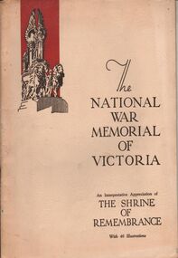 Bendigo Historical Society Inc.
Book - AILEEN AND JOHN ELLISON COLLECTION: THE NATIONAL WAR MEMORIAL OF VICTORIA
... Contents: The Shrine of Remembrance - The call and the response - The past speaks to the present - Dedicatory descriptions - The Greek tradition - General design - Architectural features - The buttress group - Dome promenades - The north and south porticos and the tympana - Floodlighting - Battle honors - The inner chamber - The roll of fame - The king's book - Ambulatory and stairs - The sanctuary - The stone of remembrance - The gleaming bay - The crypt - The final message - Subsidiary memorials - The lone pine tree - Other memorial trees - Birdwood avenue - Historical record of the Shrine of Remembrance....Contents: The Shrine of Remembrance - The call and the response - The past speaks to the present - Dedicatory descriptions - The Greek tradition - General design - Architectural features - The buttress group - Dome promenades - The north and south porticos and the tympana - Floodlighting - Battle honors - The inner chamber - The roll of fame - The king's book - Ambulatory and stairs - The sanctuary - The stone of remembrance - The gleaming bay - The crypt - The final message - Subsidiary memorials - The lone pine tree - Other memorial trees - Birdwood avenue - Historical record of the Shrine of Remembrance. ...The National War Memorial of Victoria, an interpretative appreciation of The Shrine of Remembrance, with 46 illustrations. This moment was erected by a grateful people to the honoured memory of the men and women of Victoria who served the empire in the great war of 1914-1918. The book has 44 pages. Contents: The Shrine of Remembrance - The call and the response - The past speaks to the present - Dedicatory descriptions - The Greek tradition - General design - Architectural features - The buttress group - Dome promenades - The north and south porticos and the tympana - Floodlighting - Battle honors - The inner chamber - The roll of fame - The king's book - Ambulatory and stairs - The sanctuary - The stone of remembrance - The gleaming bay - The crypt - The final message - Subsidiary memorials - The lone pine tree - Other memorial trees - Birdwood avenue - Historical record of the Shrine of Remembrance.books, military, shrine of remembrance -
 The Beechworth Burke Museum
Photograph
... pine, bilsted, redgum, satin-walnut, star-leaved gum, alligatorwood, or simply sweetgum. On the right is a row of English Oak trees commonly known as common oak, pedunculate oak, or European oak. Behind the English oaks is Old Beechworth Goal. Many of the trees in the Beechworth township were planted in the 1860's and today have exceptional historical, botanical or cultural value. Their place within the built environment reflects the importance in the Victorian era of town planning for a community, wealthy in gold and civic pride. beechworth acacia avenue ...This photograph was taken of an avenuw of acacias on Sydney Rd, Beechworth. Picture on the left hand-side is a row of Liquidamber trees also known as American storax, hazel pine, bilsted, redgum, satin-walnut, star-leaved gum, alligatorwood, or simply sweetgum. On the right is a row of English Oak trees commonly known as common oak, pedunculate oak, or European oak. Behind the English oaks is Old Beechworth Goal. Many of the trees in the Beechworth township were planted in the 1860's and today have exceptional historical, botanical or cultural value. Their place within the built environment reflects the importance in the Victorian era of town planning for a community, wealthy in gold and civic pride.Black and white rectangular photograph. The image is printed on gloss photographic paper and mounted on cardboard. Obverse: NO INSCRIPTION Reverse: 7760 The old Acacia Avenue alongside the jail. Sydney Road Beechworth Gardens & Parks beechworth, acacia avenue, gaol, sydney road, burke museum, photograph, post card, english oak, liquidambar -
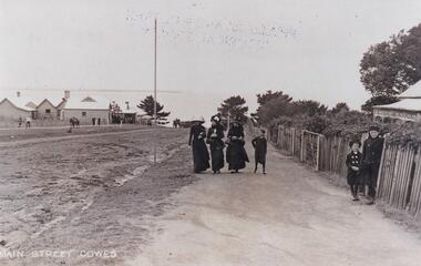 Phillip Island and District Historical Society Inc.
Photograph, Cowes Phillip Island, 1920
... Pine in the background. On right side of road on footpath are three women and a child. The women are attired in long black dresses and large smart hats. Along side them is a picket fence, shrubby garden and a house. A small child and male figure popping out the gate. local history photographs streetscape cowes black & white photograph mary robb Main Street Cowes Thompson Avenue, Cowes Cowes Phillip Island Photograph Photograph ...A stretch of the main Street of Cowes, looking towards Westernport Bay. A narrow strip of the Peninsula in the background. Left side of road depicts a group of buildings and Post Office. A Norfolk Pine in the background. On right side of road on footpath are three women and a child. The women are attired in long black dresses and large smart hats. Along side them is a picket fence, shrubby garden and a house. A small child and male figure popping out the gate.Thompson Avenue, CowesMain Street Coweslocal history, photographs, streetscape, cowes, black & white photograph, mary robb -
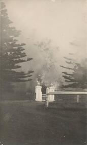
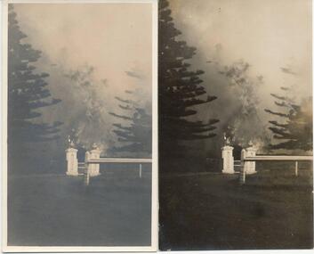 Phillip Island and District Historical Society Inc.
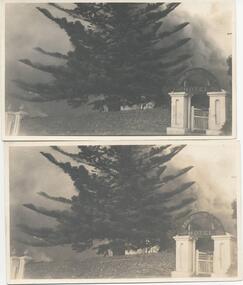
Photograph, Isle of Wight Fire, 23/04/1925
... Phillip Island and District Historical Society Inc. phillip-island-and-the-bass-coast One of a collection of photographs taken by Jessie Smith ("girlie") of San Remo, who owned the Penguin Cafe in Thompson Avenue, Cowes, Phillip Island. phillip island isle of wight hotel fire, phillip island jessie smith penguin cafe, cowes Sepia photographs or the Isle of Wight Hotel fire showing gateway - 2 pines and railed fence. ...One of a collection of photographs taken by Jessie Smith ("girlie") of San Remo, who owned the Penguin Cafe in Thompson Avenue, Cowes, Phillip Island.Sepia photographs or the Isle of Wight Hotel fire showing gateway - 2 pines and railed fence. Two identical photographs. Fire 23/4/1925phillip island, isle of wight hotel fire, phillip island, jessie smith, penguin cafe, cowes -
 Phillip Island and District Historical Society Inc.
Photograph, 23/04/1925
... Phillip Island and District Historical Society Inc. phillip-island-and-the-bass-coast Photograph taken by Jessie "Girlie" Smith of San Remo who owned the Penguin Cafe in Thompson Avenue, Cowes. phillip island isle of wight hotel fire jessie smith Photograph of scene during fire at Isle of Wight Hotel. Gateway and Norfolk Island pine ...Photograph taken by Jessie "Girlie" Smith of San Remo who owned the Penguin Cafe in Thompson Avenue, Cowes.Photograph of scene during fire at Isle of Wight Hotel. Gateway and Norfolk Island pine. Smoke.phillip island, isle of wight hotel fire, jessie smith -
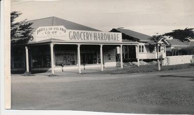 Phillip Island and District Historical Society Inc.
Photograph, 1959
... Avenue, Cowes. Two weatherboard houses to the right of building. Three Pine trees....Avenue, Cowes. Two weatherboard houses to the right of building. Three Pine trees. ...Donated by Jack JennerBlack & White photograph of the Phillip Island co-op on the cnr Chapel Street & Thompson Avenue, Cowes. Two weatherboard houses to the right of building. Three Pine trees.On back: "Site of Southern Trading Store immediately before building. Date should be easy to obtain" (August 1959)phillip island co-op store, chapel street cowes, thompson avenue cowes, phillip island, jack jenner -
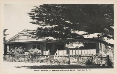 Phillip Island and District Historical Society Inc.
Photograph - Post Card, Early 1900's
... Avenue, Cowes. House has verandah with garden behind a fence and a pine tree providing shade in the street outside....Avenue, Cowes. House has verandah with garden behind a fence and a pine tree providing shade in the street outside. ...One of a collection of photographs purchased by the Society from Jack Day of Mornington.Black & White postacrd of Marldon Guest House. Situated in an elevated position over looking bay in Thompson Avenue, Cowes. House has verandah with garden behind a fence and a pine tree providing shade in the street outside."Murray Views No. 21" "Marldon Guest House, Cowes, Phillip Island, Vic." On Back: "Dear Matre, We are having a nice time here. It is my birthday today and we had a cake with three candles and I got 2 ribbons and some sweeties and some hankies. Will see you on Sat. Love Lyn. Addressed to: Mrs C. Henderson,17 Woodmason Street, Malvern, Melbourne."marldon guest house, cowes, phillip island, jack day collection -
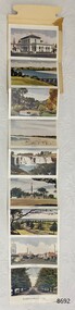 Flagstaff Hill Maritime Museum and Village
Postcard - Postcard Folder set, Valentine Publishing Co. Pty. Ltd. Melbourne and Sydney, Beautiful Views in Colour of WARRNAMBOOL VIC, 1930-50
... Flagstaff Hill Maritime Museum and Village Great Ocean Road Warrnambool Flagstaff Hill postcard postcard folder Warrnambool Scenes Picturesque views of Warrnambool Souvenir Hopkins River Botanic Gardens Post Office Beach Hopkins Falls War Memorial Avenue of Pines Liebig St Beach Rd and Harbour 1930s 1940s Valentine Publishing Co. ...Postcard folders such as these were popular as holiday souvenirs in the early to mid-20th century and were kept in good condition by collectors. The size is convenient for posting to friends and relatives and packing as holiday luggage. The images of iconic Warrnambool sights in this postcard folder were most likely taken during the 1930s-40s looking at the cars in the picture of Liebig St. The Valentine Publishing Co. Pty. Ltd., Melbourne and Sydney, was formed in 1923 so date the folder after this date. The postcards in this folder record images of local Warrnambool history from the early to mid 20th century. They are able to be used as a record of changes to structures and land formations around Warrnambool over time.A postcard folder containing nine coloured images of photographed scenes showcasing Warrnambool and district around the 1930s-1940s. The images are printed on one side of a long strip of white paper that is Z-folded and attached to a cover of heavier cream card. The front of the folder has a picture of a tree framing a beach scene, the title ‘Beautiful Views in Colour of WARRNAMBOOL VIC.’ and an address area. Slits on the rear cover enable the folder to be secured.flagstaff hill maritime museum and village, great ocean road, warrnambool, flagstaff hill, postcard, postcard folder, warrnambool scenes, picturesque views of warrnambool, souvenir, hopkins river, botanic gardens, post office, beach, hopkins falls, war memorial, avenue of pines, liebig st, beach rd and harbour, 1930s, 1940s, valentine publishing co. pty. ltd. melbourne & sydney -
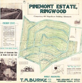 Ringwood and District Historical Society
Poster, Land Sale Advertisement - Pinemont Estate, Ringwood, Victoria - circa 1924
... Subdivision includes Wonga Road (later Loughnan's Road), Glenvale Road, Kubba Road, Felix Crescent, Summit Crescent, Pine Crescent, Aurum Crescent, Hygeia Parade, Panorama Avenue, Avalon Grove, Montalbo Road, Cielterre Avenue. ...Ringwood and District Historical Society 125A Warrandyte Road Ringwood North melbourne Subdivision includes Wonga Road (later Loughnan's Road), Glenvale Road, Kubba Road, Felix Crescent, Summit Crescent, Pine Crescent, Aurum Crescent, Hygeia Parade, Panorama Avenue, Avalon Grove, Montalbo Road, Cielterre Avenue. ...Map of residential allotments for sale, with terms of sale, summary of subdivision features and local services and facilities, and photographs of local street scene and lake (Loughnan's Lake - location not marked), Subdivision includes Wonga Road (later Loughnan's Road), Glenvale Road, Kubba Road, Felix Crescent, Summit Crescent, Pine Crescent, Aurum Crescent, Hygeia Parade, Panorama Avenue, Avalon Grove, Montalbo Road, Cielterre Avenue. Sole Agents T.M. Burke Pty Ltd, 340 Collins Street Melbourne Phones 6294, 6779. Map by S. Callanan, Licensed Surveyor, 107 Elizabeth Street Melbourne. Date of poster estimated from railway services information extract " ... 36 fast electric trains to Flinders Street daily ... proposed electrification to Croydon ..." . Timeline for electrification of Lilydale Line record indicates Box Hill to Ringwood January 1923, Ringwood to Croydon November 1924 (Source: History of Croydon - McGivern, Vol.1 p20). -
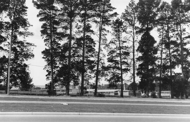 Ringwood and District Historical Society
Photograph, Croydon West High School off Cutts Avenue and Maroondah Hwy, Ringwood - November, 1969
... pine trees was used as a training ground by the Wilhelmina Soccer Club, later called Ringwood City SC and Ringwood FC. It was later sub-divided and the two streets named Wilhelmina and Juliana Courts, in honor of Wilhelmina, Queen of the Netherlands, and her daughter, Juliana, later succeeding her as Queen. The Burnt Bridge Shopping Centre can be seen in the far west on one of the images. Croydon West High School off Cutts Avenue ...Written on backing sheet, "West Croydon School (In Ringwood municipality)". November 1969. The area behind the pine trees was used as a training ground by the Wilhelmina Soccer Club, later called Ringwood City SC and Ringwood FC. It was later sub-divided and the two streets named Wilhelmina and Juliana Courts, in honor of Wilhelmina, Queen of the Netherlands, and her daughter, Juliana, later succeeding her as Queen. The Burnt Bridge Shopping Centre can be seen in the far west on one of the images. -
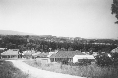 Ringwood and District Historical Society
Photograph, Jewkes pine forest in Mullum Road. Ringwood. 1958
... Written next to photograph, "Jewkes pine forest in Mullum Road. Looking down from Wonga Road to Collett Avenue, 1958."...Ringwood and District Historical Society 125A Warrandyte Road Ringwood North melbourne Written next to photograph, "Jewkes pine forest in Mullum Road. Looking down from Wonga Road to Collett Avenue, 1958." ...Written next to photograph, "Jewkes pine forest in Mullum Road. Looking down from Wonga Road to Collett Avenue, 1958."