Showing 744 items matching "plan of survey"
-
 Emerald Museum & Nobelius Heritage Park
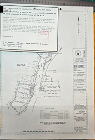
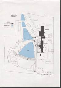
Map - Plan of Survey Acquire & Declare Proposed Action Belgrave-Gembrook Rd., Shire of Sherbrooke, Plan of Survey acquire and declare proposed action, Belgrave-Gembrook Rd, c1988
... Plan of Survey Acquire & Declare Proposed Action Belgrave-Gembrook Rd., Shire of Sherbrooke...Plan of Survey acquire and declare proposed action, Belgrave-Gembrook Rd....Image of Plan of Survey Acquire & Declare Proposed Action Belgrave-Gembrook Rd., Shire of Sherbrooke...SP17861/Land Information and survey Group/Plan of Survey/Counties of Evelyn and Mornington, Parish of Gembrook, Township of Emerald, part of former Govt. ...Map Plan of Survey Acquire & Declare Proposed Action Belgrave-Gembrook Rd., Shire of Sherbrooke ...Image of Plan of Survey Acquire & Declare Proposed Action Belgrave-Gembrook Rd., Shire of SherbrookeSP17861/Land Information and survey Group/Plan of Survey/Counties of Evelyn and Mornington, Parish of Gembrook, Township of Emerald, part of former Govt. Road Section A Part of Crown Allotment 18, Part of recreation Reserve (Crown Allotment 11C), Part of mechanics Institute & Free Library reserve (Crown Allotment 11B)/AMG REFERENCE 7922/55/363200/5800700/municipality, shire of Sherbrooke/Proposed Action, Belgrave-Gembrook Road Acquire & Declare 1 & 4 to 6, revoke & declare 2 & 3/Albert McLaren, Road Construction Authority, 60 Denmark Street, Kew 5th December 1988, (signed) A M Larson, Licensed Surveyor/Approved JD Murray 9/12/88, Manager - Land Information and Survey Group -
 Emerald Museum & Nobelius Heritage Park
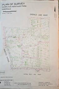
Map - Plan of Survey - Nobelius Heritage Park 2013, L. Nobelius, Nobelius Heritage Park, Plan of Survey 2013, c2013
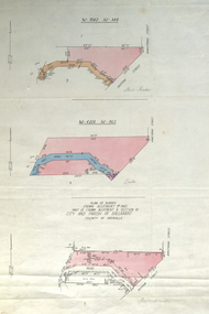
... Plan of Survey - Nobelius Heritage Park 2013...Nobelius Heritage Park, Plan of Survey 2013...Image of Plan of Survey of Nobelius Heritage Park, Emerald...Nobelius Historical connection between surveyor and the park's creator Topographical map of Nobelius Heritage Park/Denotes tree positions/Scale 1:1000 (A3)/drawn by L.NOBELIUS 20/3/2013/Survey Ref Number 5884/Nobelius Land Surveyors, PO Box 461, Pakenham 3810, Ph 03 9541 4112 Image of Plan of Survey of Nobelius Heritage Park, Emerald Nobelius Heritage Park, Plan of Survey 2013 Map Plan of Survey - Nobelius Heritage Park 2013 L. ...Survey map printed by L. NobeliusHistorical connection between surveyor and the park's creatorImage of Plan of Survey of Nobelius Heritage Park, EmeraldTopographical map of Nobelius Heritage Park/Denotes tree positions/Scale 1:1000 (A3)/drawn by L.NOBELIUS 20/3/2013/Survey Ref Number 5884/Nobelius Land Surveyors, PO Box 461, Pakenham 3810, Ph 03 9541 4112 -
 Emerald Museum & Nobelius Heritage Park
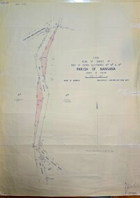
Map - Plan of Survey of Crown Allotments, Healesville - Koo Wee Rup Road, Shire of Berwick, c1969
... Plan of Survey of Crown Allotments, Healesville - Koo Wee Rup Road, Shire of Berwick...Plan of Survey of Crown Allotments, Healesville - Koo Wee Rup Road, Shire of Berwick...C.R.B./Plan of Survey of part of Crown Allotments 61A, 61B and 61E/Parish of Nangana, County of Evelyn/Shire of Berwick/Healesville0KooWeeRup Road...Emerald Museum & Nobelius Heritage Park 5 Crichton Rd Emerald yarra-valley-and-the-dandenong-ranges C.R.B./Plan of Survey of part of Crown Allotments 61A, 61B and 61E/Parish of Nangana, County of Evelyn/Shire of Berwick/Healesville0KooWeeRup Road Image of Survey of Crown Allotments 61A, 61B & 81E, Parish of Nangana Plan of Survey of Crown Allotments, Healesville - Koo Wee Rup Road, Shire of Berwick Map Plan of Survey of Crown Allotments, Healesville - Koo Wee Rup Road, Shire of Berwick ...Image of Survey of Crown Allotments 61A, 61B & 81E, Parish of NanganaC.R.B./Plan of Survey of part of Crown Allotments 61A, 61B and 61E/Parish of Nangana, County of Evelyn/Shire of Berwick/Healesville0KooWeeRup Road -
 Bendigo Historical Society Inc.
Plan - MCCOLL, RANKIN AND STANISTREET COLLECTION: PLAN OF SURVEY OF DAM SITE, 1941
... MCCOLL, RANKIN AND STANISTREET COLLECTION: PLAN OF SURVEY OF DAM SITE...... Plan of Survey of Dam site...McColl Rankin & Stanistreet, Plan of Survey of Dam site, Part of Crown Allotment 98 Section C, City of Bendigo, Parish of Sandhurst, County of Bendigo. ...No Liability Plan MCCOLL, RANKIN AND STANISTREET COLLECTION: PLAN OF SURVEY OF DAM SITE ...McColl Rankin & Stanistreet, Plan of Survey of Dam site, Part of Crown Allotment 98 Section C, City of Bendigo, Parish of Sandhurst, County of Bendigo. Signed by Garnet G Birch 1 Feb 1941. 33.5 x 43. Attached is a Copy of Field notes, Dam Site in Crown Allotment 198 Sec. City of Bendigo, Parish of Sandhurst. True Meridian, County of Bendigo, Area 0A 1R 16P. Signed Garnet G Birch, 1/2/1941. Drawn in red and black pen. 20.8 x 33. Both maps are for Deborah Extended Gold Mining Co. No Liabilityorganization, mining, deborah extended gold mining co nl, mccoll rankin & stanistreet, plan of survey of dam site -
 Emerald Museum & Nobelius Heritage Park
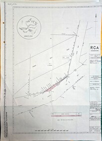
Map - Plan of Survey County of Evelyn Crown Allotment 51, Belgrave - Gembrook Rd. Acquire & declare, Near Lawson Rd, Acquire & declare Crown Allotment 51, Belgrave - Gembrook Rd, c1988
... Plan of Survey County of Evelyn Crown Allotment 51, Belgrave - Gembrook Rd. ...Image of Plan of Survey County of Evelyn Crown Allotment 51, Belgrave - Gembrook Rd. ...RCA/Survey and Mapping/Plan of Survey/ County of Evelyn, Parish of Gembrook, Part of Crown Alloment 51/A.M.G. reference 792/55/364200/5801000/Municipality - Shire of Sherbrooke/Proposed Action Belgrave - Gembrook Road - Acquire & Declare/Plan prepared and signed by John E. ...Acquire & declare Crown Allotment 51, Belgrave - Gembrook Rd. Map Plan of Survey County of Evelyn Crown Allotment 51, Belgrave - Gembrook Rd. ...Image of Plan of Survey County of Evelyn Crown Allotment 51, Belgrave - Gembrook Rd. Acquire & declare, Near Lawson Rd.RCA/Survey and Mapping/Plan of Survey/ County of Evelyn, Parish of Gembrook, Part of Crown Alloment 51/A.M.G. reference 792/55/364200/5801000/Municipality - Shire of Sherbrooke/Proposed Action Belgrave - Gembrook Road - Acquire & Declare/Plan prepared and signed by John E. Tulloch, 60 Denmark Street, Kew/10th March 1988/Approved Manager of Survey & Mapping - JD Murray 2-6-88/File number 87/17936/1/Survey Register Number 622/SP 17583 -
 Lakes Entrance Historical Society
Plan - Diagram Plan of Survey at Mount Barkly Gipps Land Lakes
... Diagram Plan of Survey at Mount Barkly Gipps Land Lakes...Plan of survey at Mount Barkly...Lakes Entrance Historical Society 4 Marine Parade Lakes Entrance gippsland Plan of waterways, The Narrows, North Arm, Reeves River to the Entrance, Snake Island, Lancet Island, Rigby Island Southern Ocean Waterways Islands Ocean Plan of survey at Mount Barkly Plan Diagram Plan of Survey at Mount Barkly Gipps Land Lakes ...Plan of waterways, The Narrows, North Arm, Reeves River to the Entrance, Snake Island, Lancet Island, Rigby Island Southern OceanPlan of survey at Mount Barklywaterways, islands, ocean -
 Federation University Historical Collection
Plan, Plan of Survey Crown Allotment 9A and Part of Crown Allotment 8 Section 10 City and Parish of Ballaarat, after 1929
... Plan of Survey Crown Allotment 9A and Part of Crown Allotment 8 Section 10 City and Parish of Ballaarat......plan of survey...ballaraat ballarat plan plan of survey armstrong street skipton street text and measurements ink and watercolor on watermarked laid paper dated 1928 Plan of Survey Crown Allotment 9A and Part of Crown Allotment 8 Section 10 City and Parish of Ballaarat Plan Plan ...ink and watercolor on watermarked laid paper dated 1928text and measurementsballaraat, ballarat, plan, plan of survey, armstrong street, skipton street -
 Ringwood and District Historical Society
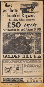
Article - Newspaper Clipping, Land Sale Advertisements, Golden Hill Estate, Ringwood - 1965, 1966, and Plan of Survey of Lot 8, Mullum Mullum Road Ringwood, 1970
... Land Sale Advertisements, Golden Hill Estate, Ringwood - 1965, 1966, and Plan of Survey of Lot 8, Mullum Mullum Road Ringwood, 1970....Attachments include reference to Lot 46 as site of original Peter Vergers' orchard residence and subsequent 1970 surveyor's Plan of Survey of Lot 8 Mullum Mullum Road Ringwood, LP 67513, Cert of Title 8581/429....(Phone) 26-2443, A.H. 850-2195. Plan of Survey signed on 25.7.1970 by Roger M. Gamble, Land Surveyor, 28 Summit Crescent, Ringwood 3134....(Phone) 26-2443, A.H. 850-2195. Plan of Survey signed on 25.7.1970 by Roger M. Gamble, Land Surveyor, 28 Summit Crescent, Ringwood 3134. ...Newspaper clippings from Melbourne Sun newspaper (11th December 1965 and 15th January 1966) advertising sale of land - Golden Hill Estate, Ringwood, with summary of features and aerial photograph including artistic representation of street layout. Subdivision includes Mullum Mullum Road, Sonia Street, Jill Court, Linda Drive, Eve Court, Alma Court, and Jacynthe Court. Attachments include reference to Lot 46 as site of original Peter Vergers' orchard residence and subsequent 1970 surveyor's Plan of Survey of Lot 8 Mullum Mullum Road Ringwood, LP 67513, Cert of Title 8581/429.Agent - Aaron, King & Co., Suite 2, 33 Queens Road, Melbourne. (Phone) 26-2443, A.H. 850-2195. Plan of Survey signed on 25.7.1970 by Roger M. Gamble, Land Surveyor, 28 Summit Crescent, Ringwood 3134. -
 Melbourne Tram Museum
Drawing, "Plan of Survey of Part of Crown Allotments 15 and 16 at Hawthorn, Parish of Boroondara, County of Bourke", 1922
... "Plan of Survey of Part of Crown Allotments 15 and 16 at Hawthorn, Parish of Boroondara, County of Bourke"...Drawing, coloured with water based drawing wash, titled "Plan of Survey of Part of Crown Allotments 15 and 16 at Hawthorn, Parish of Boroondara, County of Bourke". ...Stored folded. "Plan of Survey of Part of Crown Allotments 15 and 16 at Hawthorn, Parish of Boroondara, County of Bourke" Drawing H. ...Drawing, coloured with water based drawing wash, titled "Plan of Survey of Part of Crown Allotments 15 and 16 at Hawthorn, Parish of Boroondara, County of Bourke". Shows the tram track, Wallen Road, changes around the intersection with Power St, buildings. A note at the bottom notes who owns what - MMTB and City of Hawthorn. Prepared by H. S. McComb, licensed Surveyor 6-9-1922. Stored folded.Stamped "Drawing Office" "Office Copy" and in red pencil "Hawthorn" in the bottom right hand corner, and on the rear "Drawing Office" "Office Copy" and "Hawthorn Depot" in pencil.trams, tramways, htt, mmtb, hawthorn depot, plans -
Whitehorse Historical Society Inc.
Map, Plan of special survey selected by H. Elgar Esq, 1841
... Plan of special survey selected by H. Elgar Esq.... Note on verso: Plan of special survey selected by H. Elgar Esq in the Parishes of Boroondara and Nunawading, County of Bourke. ...Note on verso: Plan of special survey selected by H. Elgar Esq in the Parishes of Boroondara and Nunawading, County of Bourke. ...Boroondara Special Survey B.17, with attached descriptive note by T. H. Nott. Plan of special survey selected by H. ...Photocopy of plan and listing of corner stakes.Photocopy of plan and listing of corner stakes. Note on verso: Plan of special survey selected by H. Elgar Esq in the Parishes of Boroondara and Nunawading, County of Bourke. Surveyed by T.H. Nott (?Sydney) 31 May 1841. Boroondara Special Survey B.17, with attached descriptive note by T. H. Nott.Photocopy of plan and listing of corner stakes. maps, parish of boroondara, parish of nunawading, elgar, h, nott, t.h. -
 Ringwood and District Historical Society
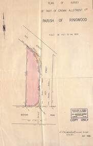
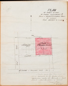
Document - Plan of Survey, Part of Crown Allotment 17D, Parish of Ringwood - 1961
... Plan of Survey ...Part of Crown Allotment 17D, Parish of Ringwood - 1961 Document Plan of Survey ...Map of property shaded pink along Pitt Street from Bedford Road corner, Ringwood, Victoria.Signature, date and rubber stamp of Kirkpatrick & Webber, Surveyors & Engineers, 225 Maroondah Highway, Ringwood, Telephone WU 8969, 6/4/'61. -
 Ringwood and District Historical Society
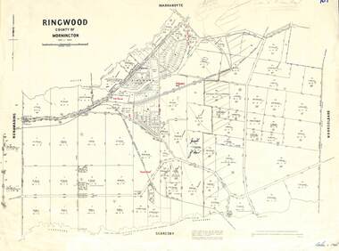
Map - 1957 Reproduction of Plan of Survey, Parish of Ringwood, County of Mornington
... 1957 Reproduction of Plan of Survey ...Parish of Ringwood, County of Mornington Map 1957 Reproduction of Plan of Survey ...Updated original 1878 map with names of early selectors in area bounded by Nunawading, Warrandyte, Scoresby and Mooroolbark, and Mullum Mullum & Dandenong Creeks.Authorised by W.M. Houston, Government Printer, Melbourne. Drawn and reproduced at the Department of Lands and Survey, Melbourne - 1957. -
 Ringwood and District Historical Society
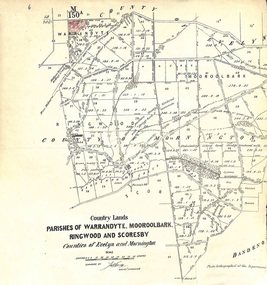
Map - Plan of Survey, Country Lands, Parishes of Warrandyte, Mooroolbark, Ringwood and Scoresby, Counties of Evelyn and Mornington - circa 1855
... Plan of Survey ...Country Lands, Parishes of Warrandyte, Mooroolbark, Ringwood and Scoresby, Counties of Evelyn and Mornington - circa 1855. Map Plan of Survey ...Clipped section of larger survey map including descriptions of treed areas and topographical features. Surveyed by (signature of J. Hardy) - Assistant Surveyor. -
 Ringwood and District Historical Society
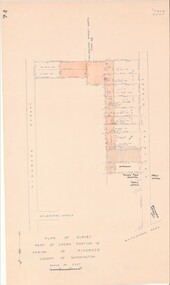
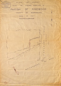
Map - Plan of Survey, Part of Crown Portion 12, Parish of Ringwood, Victoria - circa 1930
... Plan of Survey...Part of Crown Portion 12, Parish of Ringwood, Victoria - circa 1930. Map Plan of Survey ...Map of area bounded by Ringwood Street, Melbourne Street and Adelaide Street, showing details of Adelaide Street allotments and existing outbuildings. Certificate of Title numbers include Ringwood Street C/T 3418-553, C/T 3563-433, Adelaide Street C/T 7151-047, C/T 7038-465, C/T 7098-464, C/T 7098-465, C/T 3604-635, C/T 8066-900, C/T 3866-118, C/T 3609-728, and C/T Vol 3670 Fol 133992.Subsequent additional notations identifying 1971 closure of Melbourne Street North, and properties of Hone, Patendon, Pines Hosptial, Mail Office, Presbyterian Church and Falconers Grocery Shop on Whitehorse Road corner. -
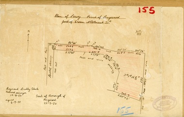 Ringwood and District Historical Society
Map, Plan of Survey, Parish of Ringwood - Part of Crown Allotment 31A - 1950
... Plan of Survey, Parish of Ringwood - Part of Crown Allotment 31A - 1950..., Ringwood East. Plan of Survey, Parish of Ringwood - Part of Crown Allotment 31A - 1950 Map ...Hand drawn and labelled copy of map with survey measurements of allotment on Isobel Avenue (Isabel Avenue?), Ringwood East. Raymond Dudley Steele Licensed Surveyor 10-8-50, signed 6-9-50, Seal of Borough of Ringwood 26-9-50. Rubber stamp - Dugdale, Simmons & Stevens, Solicitors, Peacock House, 486 Bourke Street Melbourne. Typewritten heading on backing paper - Capt. M.H. Moyes - Correspondence Supplementary to Statements. -
 Ringwood and District Historical Society
Map, Plan of Survey, Part of CP12, Adelaide Street, Ringwood, Circa 1920s
... Plan of Survey, Part of CP12, Adelaide Street, Ringwood, Circa 1920s...Macey, Licensed Surveyor 36 Narissa Street Burwood BX1917. Plan of Survey, Part of CP12, Adelaide Street, Ringwood, Circa 1920s Map ...Undated map of part of commercial area in Parish of Ringwood, County of Mornington showing Adelaide Street, Whitehorse Road, and un-named laneway behind Whitehorse Road shops marked as Road, and New Road Alignment. Made by H.J. Macey, Licensed Surveyor 36 Narissa Street Burwood BX1917. -
 Bacchus Marsh & District Historical Society
Map, Plan of Survey of Part of Crown Allotment 9, Parish of Korkuperrimul, 1890
... Plan of Survey of Part of Crown Allotment 9, Parish of Korkuperrimul, 1890...At bottom of map: I hereby certify that I have made this survey expressly for the purpose of an application under the Transfer of Land Statute that this plan is correct. ...High resolution digital image stored on BMDHS computer network. Plan of Survey of Part of Crown Allotment 9, Parish of Korkuperrimul, 1890 Map Shire of Bacchus Marsh ...This map documents a transfer of an allotment of land in Clarke Street Bacchus Marsh in 1890. Clarke Street is located on the eastern side of Bacchus Marsh not far from Main Street and Crook Street. It is now known as Candeloro Street. The map indicates J. Booth as the owner of the land and H. Simpson as the occupier. Next to this allotment is a an allotment of land owned by J. Elmore,Single page map showing Crown allotment 9, Parish of Korkuperrimul, County of Bourke. Scale 100 feet to inch. Part of a set of maps which are pasted into a bound volume containing 76 maps or plans in total. High resolution digital image stored on BMDHS computer network. At bottom of map: I hereby certify that I have made this survey expressly for the purpose of an application under the Transfer of Land Statute that this plan is correct. Barry B???, Lic. Surveyor, 16.10.90bacchus marsh victoria maps, clarke street bacchus marsh maps -
 Federation University Historical Collection
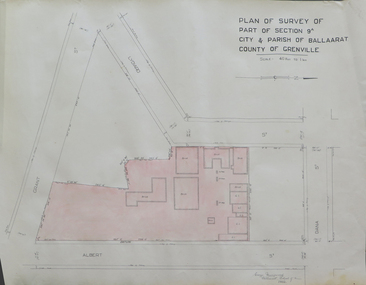
Plan, Plan of Survey of Part of Section 9A City & Parish of Ballarat County of Grenville (Albert Street frontage), 1932
... Plan of Survey of Part of Section 9A City & Parish of Ballarat County of Grenville (Albert Street frontage)...Plan of SMB showing Albert, Grant, Lydiard and Dana streets, on paper with colored highlights undertaken by Ballarat School of Mines student George Murrowood in 1932 2. Hand written page by George Murrowood, of technical description of land surveying... Grade II 1932 Plan of Survey of Part of Section 9A City & Parish of Ballarat County of Grenville (Albert Street frontage) Plan Plan George Murrowood ...The M.B. John Trade Building was built on the Albert Street Frontage.1. Plan of SMB showing Albert, Grant, Lydiard and Dana streets, on paper with colored highlights undertaken by Ballarat School of Mines student George Murrowood in 1932 2. Hand written page by George Murrowood, of technical description of land surveying Grade II 1932ballarat school of mines, surveying, george murrowood, albert street, alumni, m.b. john building, architectural plan -
 Bendigo Historical Society Inc.
Document - NORM HARRIS COLLECTION: PLAN OF 'FORTUNA 'ARMY SURVEY REGIMENT
... NORM HARRIS COLLECTION: PLAN OF 'FORTUNA 'ARMY SURVEY REGIMENT...Norm Harris Collection Plan of 'Fortuna 'Army Survey Regiment showing original buildings , original lakes and existing details together with Roman bath and a tunnel....Document NORM HARRIS COLLECTION: PLAN OF 'FORTUNA 'ARMY SURVEY REGIMENT ...Norm Harris Collection Plan of 'Fortuna 'Army Survey Regiment showing original buildings , original lakes and existing details together with Roman bath and a tunnel.plan, bendigo -
 Bendigo Historical Society Inc.
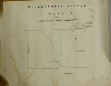
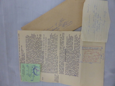
Plan - MARKS COLLECTION: PLAN OF UNDERGROUND SURVEY G. DENNIS MINE
... MARKS COLLECTION: PLAN OF UNDERGROUND SURVEY G. DENNIS MINE...Plan drawn on heavy parchment 'underground survey G. Dennis' printed on top of plan. ...Plan MARKS COLLECTION: PLAN OF UNDERGROUND SURVEY G. DENNIS MINE ...Plan drawn on heavy parchment 'underground survey G. Dennis' printed on top of plan. Plan shows boundary lines and peg site. P. Bonati claim marked on bottom of plan. B. Letter with plan on letterhead 'City of Sandhurst, Town Hall, July 2nd. 1873' Addressed to Mr. George Dennis, Sir, In reply to your letter of the 19th. ulto I am empowered to state that subject to the formation of the road referred to, your existing rights are conserved, and the council will undertake not to object to the renewal of your lease. The only conditions being that you shall not sink a shaft in the street or attempt to obstruct it when formed. I have the honor to be, Sir, your obedient servant, Geo Fletcher, Town Clerk.bendigo, mining, g. dennis claim -
 Bendigo Historical Society Inc.
Document - SURVEY PLAN OF HARGREAVES & HOPETOWN STREETS
... SURVEY PLAN OF HARGREAVES & HOPETOWN STREETS...Undated survey plan by William Bockli, Consulting Engineer 422-428 Collins St Melbourne showing land between Hargreaves St and Hopetoun St Bendigo, stamped 'Hanro Aust Bendigo Knitting Mill, PTY,LTD., Job 37, drawing No 8. ...Unknown donor Document SURVEY PLAN OF HARGREAVES & HOPETOWN STREETS ...Undated survey plan by William Bockli, Consulting Engineer 422-428 Collins St Melbourne showing land between Hargreaves St and Hopetoun St Bendigo, stamped 'Hanro Aust Bendigo Knitting Mill, PTY,LTD., Job 37, drawing No 8. Scale . 30 feet to an inch. Unknown donorbendigo, industry, hanro knitting mill -
 Tatura Irrigation & Wartime Camps Museum
Map - Map - Photocopy, New Guinea Escape Route
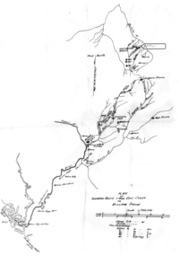
... Plan of surveyed route from Edie Creek to Bulldog Drome...Willi Hertle (Ref C0750) papua new guinea escape map wau willi hertle kiessling Plan of surveyed route from Edie Creek to Bulldog Drome Photocopy of New Guinea map showing escape route New Guinea Escape Route Map Map - Photocopy ...At the end of January 1942 there was only about 250 men left in Wau, as the women and children had been evacuated by air a little earlier. With no planes to take the men they had to make their own way to Port Moresby and then travel by ship to Australia. Some men went down to Salamaua and made their way along the north coast, but small groups also made their way over the Owen Stanley Ranges; rafting down the Lakekamu RIver to Yule Island and by boat to Port Moresby. Donor Vanessa Kiessling's Father was part of the second group, and had drawn a detailed map of their route. This might be the same route taken by Rev. Willi Hertle (Ref C0750)Photocopy of New Guinea map showing escape routePlan of surveyed route from Edie Creek to Bulldog Dromepapua new guinea, escape, map, wau, willi hertle, kiessling -
Stawell Historical Society Inc
Map, Gold Mines of Australia, Gold Mines of Australia underground workings. Newington Rd Darlington Rd Area 1950, 1950
... Plans Showing Surveys & Drilling Stawell Investment...Stawell Historical Society Inc 46 Longfield St Stawell grampians mining gold map Gold Mines of Australia Stawell Investment 2003 Plans Showing Surveys & Drilling Stawell Investment Gold Mines of Australia underground workings. ...Plans Showing Surveys & Drilling Stawell InvestmentGold Mines of Australia Stawell Investment 2003 mining, gold, map -
Lakes Entrance Historical Society
Map - Survey Mt Barkly Gippsland Lakes
... Survey No 1 Diagram Plan of Survey at Mt Barkley...Lakes Entrance Historical Society 4 Marine Parade Lakes Entrance gippsland Surveying Plan Survey No 1 Diagram Plan of Survey at Mt Barkley Map Survey Mt Barkly Gippsland Lakes ...Survey No 1 Diagram Plan of Survey at Mt Barkleysurveying, plan -
 Warrnambool and District Historical Society Inc.
Documents, Swintons Paper att 18/53 Merri St. Contract. Map. Notes, 1959
... .2 ‘Plan of Survey of Part of Crown Allotment 18 Section 3 Township of .2 ‘Plan of Survey of Part of Crown Allotment 18 Section 3 Township of Warrnambool Parish of Wangoom County of Villiers’ .3 ‘Tuesday Dear Mr Swinton I am writing to say that I would like to have the ‘Office’ Thanking You George O’Grady’...The current Swinton business in Timor Street is the oldest family business in Warrnambool and, with the name Swinton associated with businesses in Timor Street Warrnambool for 152 years it is amongst the oldest family businesses in Australia. swinton family, warrnambool .2 ‘Plan of Survey of Part of Crown Allotment 18 Section 3 Township of .2 ‘Plan of Survey of Part of Crown Allotment 18 Section 3 Township of Warrnambool Parish of Wangoom County of Villiers’ .3 ‘Tuesday Dear Mr Swinton I am writing to say that I would like to have the ‘Office’ Thanking You George O’Grady’ The items here relate to the sale of land by Swintons Pty Ltd., Warrnambool. .1 These are three pages of white paper with typed material, a lawyer’s signature in blue ink, one green stamp and a sketch of the land location. .2 This is a sheet of thick paper containing a plan of the land sold. ...These documents relate to the sale of land in Merri Street Warrnambool in 1959 by Swintons Pty Ltd of Warrnambool. The buyer of the land was George O’Grady, a Warrnambool baker. The land sold for £4000 and there was a shed on the land (called the ‘Office’) which George O’Grady indicated he wished to be included in the sale. William and Ann Swinton migrated to Australia in 1854 and for a decade William Swinton worked as a builder and carpenter in the Warrnambool area, erecting many buildings, including the Wangoom Presbyterian Church. In 1865 he opened a store in Timor Street Warrnambool, selling groceries, hardware, china and glassware. By 1888 the business was known as William Swinton and Sons. Branch stores were opened in Wangoom, Cudgee, Nullawarre, South Warrnambool and West Warrnambool. After William Swinton died his son Robert became the first managing director of Swintons Pty Ltd. In 1934 the business split with George Swinton and Sons selling clothing, furnishings and glassware and Swintons Pty Ltd selling seeds, produce and hardware. Today the Swinton family still operates a furniture and bedding shop in Timor St Warrnambool.These items are of some interest as being connected to the Warrnambool business of Swintons Pty Ltd. They will be of interest to researchers. The current Swinton business in Timor Street is the oldest family business in Warrnambool and, with the name Swinton associated with businesses in Timor Street Warrnambool for 152 years it is amongst the oldest family businesses in Australia.The items here relate to the sale of land by Swintons Pty Ltd., Warrnambool. .1 These are three pages of white paper with typed material, a lawyer’s signature in blue ink, one green stamp and a sketch of the land location. .2 This is a sheet of thick paper containing a plan of the land sold. The paper has printed material and a sketch of the land with part of it coloured in pink. .3 This is a small piece of paper torn at the bottom right edge. It has handwritten material (a letter) in blue ink..2 ‘Plan of Survey of Part of Crown Allotment 18 Section 3 Township of .2 ‘Plan of Survey of Part of Crown Allotment 18 Section 3 Township of Warrnambool Parish of Wangoom County of Villiers’ .3 ‘Tuesday Dear Mr Swinton I am writing to say that I would like to have the ‘Office’ Thanking You George O’Grady’swinton family,, warrnambool -
Southern Sherbrooke Historical Society Inc.
Map - photocopy
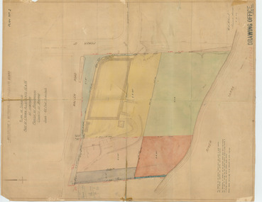
... A3 photocopy of plan of survey of part of Crown Allotments 20 & 21, section C, parish of Narre Worran, County of Mornington. ...A3 photocopy of plan of survey of part of Crown Allotments 20 & 21, section C, parish of Narre Worran, County of Mornington. ...A photocopy taken from the original land sale map provided to the society through Karel Coxell of Stockdale & Leggo. The original maps are stored in large bound account books and were originally the propert of McNally Real Estate. The books are held (in 2A3 photocopy of plan of survey of part of Crown Allotments 20 & 21, section C, parish of Narre Worran, County of Mornington. Clements Ave and environs in Belgrave Heights"Villette Estate" in top LH corner, "Locality Plan" in bottom LH corner, "Not in sale" written on one block and crossed out. All handwritten in pencil on original. "Colby Drive " and "Verona Street" added in pencil to copy.land sales, advertisements, subdivision -
 Bendigo Historical Society Inc.
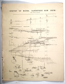
Map - SURVEY OF MINES, SANDHURST, NEW CHUM, Circa 1881
... plan...Survey of Mines ...History House 11 Mackenzie Street Bendigo goldfields MAP mining plan Survey of Mines Sandhurst New Chum Gold Mines Bendigo Map: Survey of Mines, Sandhurst, New Chum, Longtitudinal Section of the New Chum, reef. 2 sheets. ...Map: Survey of Mines, Sandhurst, New Chum, Longtitudinal Section of the New Chum, reef. 2 sheets. Sheet 5 and Sheet 8map, mining plan, survey of mines , sandhurst, new chum, gold mines bendigo -
 Bendigo Historical Society Inc.
Plan - Shenandoah and North Shenandoah mines
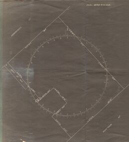
... Plan shows shafts and levels. Printed on bottom of plan: 'Surveyed by E.T. ...Plan shows shafts and levels. Printed on bottom of plan: 'Surveyed by E.T. ...The Shenandoah Gold Mine was located in High Street, opposite the (then) Fire Station in Golden Square. The North Shenandoah Gold Mine was located in Panton Street, Golden Square, approx. 300m from the corner of Thistle Street. Drawn on light tan paper, printed on top of plan: "Underground survey of mines, Sandhurst. Shenandoah and North Shenandoah'. Plan shows shafts and levels. Printed on bottom of plan: 'Surveyed by E.T. Brown under the direction of the Secretary of the Mines , Mining Department, June 1890' Plan forms part of the Margaret Roberts Collection of mining records. margaret roberts, gold, gold mine, bendigo, shenandoah and north shenandoah, high street, panton street, golden square -
Whitehorse Historical Society Inc.
Document, Division of Survey and Mapping, 1984
... Information guide to Parish and Township Plans - Division of Survey and Mapping - Victorian Government.....Information guide to Parish and Township Plans - Division of Survey and Mapping - Victorian Government.. ...Information guide to Parish and Township Plans - Division of Survey and Mapping - Victorian Government..Information guide to Parish and Township Plans - Division of Survey and Mapping - Victorian Government..Information guide to Parish and Township Plans - Division of Survey and Mapping - Victorian Government..crown lands, victorian government, land surveys -
Whitehorse Historical Society Inc.
Map, Burwood Road, Box Hill City, 15/02/1952 12:00:00 AM
... Between Milford Avenue and Station Street. Marked as Survey Plan No 5441....Plan of subdivision of ten blocks in Burwood Road, Burwood between Milford Avenue and Station Street. Marked as Survey...Plan of subdivision of ten blocks in Burwood Road, Burwood between Milford Avenue and Station Street. Marked as Survey ...Plan of subdivision of ten blocks in Burwood Road, Burwood.Plan of subdivision of ten blocks in Burwood Road, Burwood between Milford Avenue and Station Street. Marked as Survey Plan No 5441.Plan of subdivision of ten blocks in Burwood Road, Burwood. land subdivision, burwood road, burwood, milford avenue, burwood, central court, burwood