Showing 2413 items matching "planning document"
-
 Federation University Historical Collection
Document - Report, Ballarat School of Mines Planning Document for Meeting with the Minister for Education the Hon. Ian Cathie, M.P., 1986, 06/06/1986
... Ballarat School of Mines Planning Document for Meeting with the Minister for Education the Hon. ......planning document...Ballarat School of Mines planning document for a meeting with the minister for education....Barker Library (top floor) Mount Helen goldfields ballarat school of mines planning document ian cathie minister for education Ballarat School of Mines planning document for a meeting with the minister for education. ...Ballarat School of Mines planning document for a meeting with the minister for education.ballarat school of mines, planning document, ian cathie, minister for education -
Federation University Historical Collection
Report, Ballarat School of Mines Planning Document for Meeting with the Minister for Education the Hon. Robert Fordham, M.P., 1983, 16/09/1983
... Ballarat School of Mines Planning Document for Meeting with the Minister for Education the Hon. ......planning document...Ballarat School of Mines planning document for a meeting with the minister for education....Barker Library (top floor) Mount Helen goldfields ballarat school of mines planning document minister for education robert fordham Ballarat School of Mines planning document for a meeting with the minister for education. ...Ballarat School of Mines planning document for a meeting with the minister for education.ballarat school of mines, planning document, minister for education, robert fordham -
Port Melbourne Historical & Preservation Society
Book - Community Services Centre, Planning Document, 1992
... Community Services Centre, Planning Document...Community Services Centre. Planning Document 1992. Detailed planning document to co-ordinate community services and, in particular, to meet the changing needs of residents. ...Blue front page Book Community Services Centre, Planning Document Community Services Centre ...Community Services Centre. Planning Document 1992. Detailed planning document to co-ordinate community services and, in particular, to meet the changing needs of residents. City of Port Melbourne 1992. Blue front pagelocal government - city of port melbourne -
Federation University Historical Collection
Booklet, Ballarat School of Mines, Regional Unemployment: Ballarat School of Mines Planning Document 7:79, 02/1979
... Regional Unemployment: Ballarat School of Mines Planning Document 7:79...Barker Library (top floor) Mount Helen goldfields unempolyment ballarat school of mines ballarat horsham ararat mildura maryborough tullaroop creswick clunes talbot st arnaud bacchus marsh bet bet kara kara bungaree buninyong ballan dunmunkle stawell dimboola lowan kaniva kowree White cardboard cover with black plastic spine Regional Unemployment: Ballarat School of Mines Planning Document 7:79 Booklet Booklet Ballarat School of Mines ...White cardboard cover with black plastic spineunempolyment, ballarat school of mines, ballarat, horsham, ararat, mildura, maryborough, tullaroop, creswick, clunes, talbot, st arnaud, bacchus marsh, bet bet, kara kara, bungaree, buninyong, ballan, dunmunkle, stawell, dimboola, lowan, kaniva, kowree -
 Greensborough Historical Society
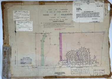
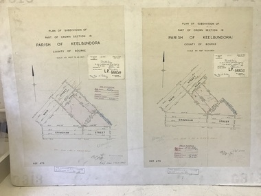
Poster - Planning Document, City of Heidelberg et al, Subdivision Plan # H 41 - Crown portion 8, Parish of Keelbundoora - Yallambie, and Crown Portion 9, Parish of Keelbundoora, 1922-1967
... Planning Document...Planning Document: Subdivision Plan # H 41 Side 1, Crown portion 8, Parish of Keelbundoora - Yallambie Road, Allima Avenue, Koolya Court, Ekam Court (Jennings Estate). ...Greensborough Historical Society 34A Glenauburn Road Lower Plenty Lower Plenty melbourne Planning Document: Subdivision Plan # H 41 Side 1, Crown portion 8, Parish of Keelbundoora - Yallambie Road, Allima Avenue, Koolya Court, Ekam Court (Jennings Estate). ...Planning Document: Subdivision Plan # H 41 Side 1, Crown portion 8, Parish of Keelbundoora - Yallambie Road, Allima Avenue, Koolya Court, Ekam Court (Jennings Estate). Side 2: Crown Portion 9, Parish of Keelbundoora consist of 5 small subdivision sheets: 1. Somers Avenue, Stewart Terrace, Toubay Street and Railway Place (no date); 2. Somers Avenue, Maxwell Street, Greensborough Road, 1924; 3. Heidelberg Avenue, Golf Avenue, St Andrews Avenue (no date); 4. Birdwood Avenue, May Street (no date); 5. Strathallan Road 1924.An example of hard copy subdivision plans from the Greensborough area. Mainly from the Shire of Diamond Valley era (1964-1994).Plan (2 sided) mounted on heavy card. Stamped and handwritten Council permissions, dates and other details.subdivision plans, city of heidelberg, yallambie, macleod, greensborough -
Federation University Historical Collection
Report, Ballarat School of Mines Report on Training for Caravan Park Managers, 1979, 02/1979
... ...planning document...Ballarat School of Mines report . Planning Document 5.79...Planning Document 5.79 Ballarat School of Mines Report on Training for Caravan Park Managers, 1979 Report ...Ballarat School of Mines report . Planning Document 5.79ballarat school of mines, planning document, tafe, caravan park managers, j.l. turner, tourism -
Federation University Historical Collection
Report, Ballarat School of Mines Pilot Conservation Project, 1980, 06/1980
... ...planning document...Submission for funds for a pilot conservation project . Planning Document 11.80...Planning Document 11.80 Ballarat School of Mines Pilot Conservation Project, 1980 Report ...Submission for funds for a pilot conservation project . Planning Document 11.80ballarat school of mines, planning document, t. white, tafe, national youth advisory group, land degredation, unemployment, economics, dryland salting -
Federation University Historical Collection
Report, Ballarat School of Mines Report on a TAFE Information Film, 1978, 04/1978
... ...planning document...Ballarat School of Mines report . Planning Document 28-78...Planning Document 28-78 Ballarat School of Mines Report on a TAFE Information Film, 1978 Report ...Script by Peter Drummond Ballarat School of Mines report . Planning Document 28-78ballarat school of mines, planning document, tafe, j.l. turner, peter drummond, film, tafe information film, film script, peter lawless, lee wallis, nancy shepherd, alistair clark, rocky hazlett, craig thomas, geoff tierney -
![Planning Document, Plan of proposed subdivision of land in Greensborough [Map shows Scotland house], 01/04/1971](/media/collectors/4f729f5697f83e03086015b8/items/5982a68921ea6b1420e4e560/item-media/59916fb521ea681094908d7a/item-fit-380x285.jpg?cb=6) Greensborough Historical Society
Greensborough Historical SocietyPlanning Document, Plan of proposed subdivision of land in Greensborough [Map shows Scotland house], 01/04/1971
... Planning Document...Plan of proposed subdivision of land in Greensborough [Map shows Scotland house] Planning Document ...This subdivision of Greensborough shows the home of John Scotland (died 1888) and surrounding area bounded by Hailes, William, Lorimer, and Jessop Streets.Photocopy of plan, 2 pages.Part of plan (68G) of proposed subdivision of Greensborough, part of Crown Portion 18, Parish pf Keelbundora. Scale: 132 ft. to an inchjohn scotland, hailes street greensborough, william street greensborough, lorimer street greensborough, jessop street greensborough -
 Greensborough Historical Society
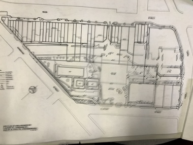
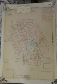
Planning Document, Banyule City Council, Site plan of Greensborough 1997, 28/07/1997
... Planning Document...This plan shows central Greensborough before the Watermarc development greensborough greensborough swimming pool Set of 8 site plans Site plan of Greensborough 1997 Planning Document Banyule City Council ...Site plans for the area bounded by Flintoff Street; Grimshaw Street; Main Street and Para Road Greensborough. these plans show the area before the development of Watermarc.This plan shows central Greensborough before the Watermarc developmentSet of 8 site plansgreensborough, greensborough swimming pool -
 Greensborough Historical Society
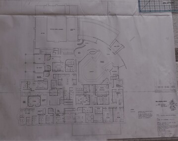
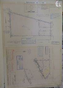
Planning Document, Shire of Diamond Valley, Civic Centre Redevelopment 1992, 1992_08
... Planning Document...Civic Centre Redevelopment 1992 Planning Document Shire of Diamond Valley ...6 plans for the proposed redevelopment of the Shire of Diamond Valley offices in Civic Drive, now the offices of Nillumbik Council. Shire of Diamond Valley existed from 1964 to 1994.6 planning drawings, black ink on white paper.shire of diamond valley, nillumbik council -
 Greensborough Historical Society
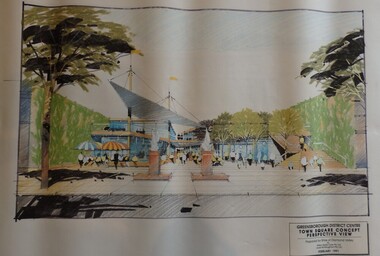
Planning Document, Shire of Diamond Valley, Greensborough District Centre, Town Square Concept Plans 1991, 1991_02
... Planning Document...Greensborough District Centre, Town Square Concept Plans 1991 Planning Document Shire of Diamond Valley ...Plans and concept drawings for the proposed development of the Greensborough District Centre, Town Square. Shire of Diamond Valley existed from 1964 to 1994.7 plans and 2 concept drawings, black and coloured ink on white paper.shire of diamond valley, greensborough -
 Greensborough Historical Society
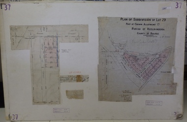
Planning Document, Subdivision Plan # 37. Poulter Avenue and Bicton Street; and, Adeline Street and Grimshaw Street Greensborough, 1971_
... Planning Document...Poulter Avenue and Bicton Street; and, Adeline Street and Grimshaw Street Greensborough Planning Document C. S. Honman ...Plan of subdivision Lot 29, Part of Crown Allotment, Parish of Keelbundoora, County of Bourke. Poulter Avenue and Bicton Street; and, Adeline Street and Grimshaw Street.An example of hard copy subdivision plans from the Greensborough area. Mainly from the Shire of Diamond Valley era (1964-1994).Plan (2 sheets) mounted on heavy card. subdivision plans, grimshaw street, poulter avenue, adeline street -
 Greensborough Historical Society
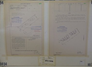
Planning Document, Subdivision Plan #1034. 50 Hume Street, 03/02/1982
... Planning Document...Subdivision Plan #1034. 50 Hume Street. Planning Document N A Webster and Associates ...Plan of Strata Subdivision at 50 Hume Street Greensborough for 7 units.An example of hard copy subdivision plans from the Greensborough area. Mainly from the Shire of Diamond Valley era (1964-1994).Plan (2 sheets) mounted on heavy card.Stamped and handwritten Council permissions, dates and other details.subdivision plan -
 Greensborough Historical Society
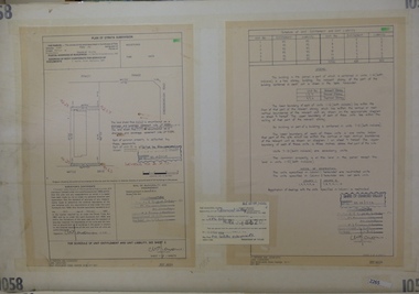
Planning Document, Subdivision Plan #1058. Wattle Drive Watsonia, 14/07/1983
... Planning Document...Wattle Drive Watsonia Planning Document M J Parsons and Associates ...Plan of Strata Subdivision at 6 Wattle Drive Watsonia for 6 units.An example of hard copy subdivision plans from the Greensborough area. Mainly from the Shire of Diamond Valley era (1964-1994).Plan (3 sheets) mounted on heavy card.Stamped and handwritten Council permissions, dates and other details.subdivision plans, wattle drive watsonia -
 Greensborough Historical Society
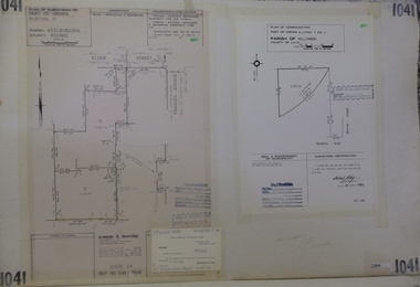
Planning Document, Subdivision Plan #1041. Elder Street Greensborough, 20/04/1983
... Planning Document...Elder Street Greensborough . Planning Document O'Connor and Beveridge ...Plan of Consolidation of Allotments 3 and 4 Brixton Avenue and Plan of Subdivision for Elder Street. An example of hard copy subdivision plans from the Greensborough area. Mainly from the Shire of Diamond Valley era (1964-1994).Plan (2 sheets) mounted on heavy card.Stamped and handwritten Council permissions, dates and other details.subdivision plans, elder street, brixton avenue -
 Greensborough Historical Society
Planning Document, Subdivision Plan # 1060, 8 Ulmara Place Greensborough, 20/04/1983
... Planning Document...Subdivision Plan # 1060, 8 Ulmara Place Greensborough. Planning Document Clive Singleton and Associates ...Plan of Strata Subdivision at 8 Ulmara Place Greensborough for 2 houses.An example of hard copy subdivision plans from the Greensborough area. Mainly from the Shire of Diamond Valley era (1964-1994).Plan (3 sheets) mounted on heavy card.Stamped and handwritten Council permissions, dates and other details.subdivision plans, ulmara place -
 Greensborough Historical Society
Planning document, Subdivision Plan #1128. St Helena Road Greensborough, 1985_
... Planning document...St Helena Road Greensborough. Planning document Lawlor and Loy ...Plan of Subdivision for property at St Helena Road. (superseded plan)An example of hard copy subdivision plans from the Greensborough area. Mainly from the Shire of Diamond Valley era (1964-1994).Plan (2 sheets) mounted on heavy card.Stamped and handwritten Council permissions, dates and other details. Notation: 'Superseded plan see G1190'subdivision plans, st helena road -
 Greensborough Historical Society
Planning Document, Subdivision Plan # 1016. Corner Weidlich and St Clems Roads Greensborough, 05/10/1981
... Planning Document...Corner Weidlich and St Clems Roads Greensborough. Planning Document Fisher Cleeland Turner and Dwyer ...Plan of Subdivision of land at corner of Weidlich Road and St Clems Road Greensborough.Plan (2 sheets) mounted on heavy card.Stamped and handwritten Council permissions, dates and other details.subdivision plans, weidlich road -
 Greensborough Historical Society
Planning document, Subdivision Plan #1011. Corner Mountainview Road and Hume Streets, 1981_
... Planning document...Corner Mountainview Road and Hume Streets. Planning document Des Bennett and Associates ...Plan of Strata Subdivision for units at corner of Mountainview Road and Hume Street Briar Hill.An example of hard copy subdivision plans from the Greensborough area. Mainly from the Shire of Diamond Valley era (1964-1994).Plan (2 sheets) mounted on heavy card.Stamped and handwritten Council permissions, dates and other details.subdivision plans, mountainview road, hume street -
 Greensborough Historical Society
Planning document, Subdivision Plan #1009. Corner Allumba Drive and Beales Road Greensborough, 1981_
... Planning document...Corner Allumba Drive and Beales Road Greensborough. Planning document Hellier Van Pty Ltd ...Plan of Subdivision of land at corner of Allumba Drive and Beales Road Greensborough.An example of hard copy subdivision plans from the Greensborough area. Mainly from the Shire of Diamond Valley era (1964-1994).Plan (2 sheets) mounted on heavy card.Stamped and handwritten Council permissions, dates and other details.subdivision plans, allumba drive, beales road -
 Greensborough Historical Society
Planning document, Subdivision Plan #1005. Corner Douglas Court and Glen Katherine Drive Greensborough, 1981_
... Planning document...Corner Douglas Court and Glen Katherine Drive Greensborough. Planning document Fisher Cleeland Turner and Dwyer ...Plan of Subdivision. Corner Douglas Court and Glen Katherine Drive Greensborough.An example of hard copy subdivision plans from the Greensborough area. Mainly from the Shire of Diamond Valley era (1964-1994).Plan (2 sheets) mounted on heavy card.Stamped and handwritten Council permissions, dates and other details.subdivision plans, douglas court, glen katherine drive -
 Greensborough Historical Society
Planning document, City of Heidelberg, Subdivision Plan # G26. Grace Park Estate Greensborough, 1950c
... Planning document...Grace Park Estate Greensborough. Planning document City of Heidelberg ...Plan of Subdivision (G26). Grace Park Estate. An example of hard copy subdivision plans from the Greensborough area. From Shire of Heidelberg.Plan mounted on heavy card.Stamped and handwritten Council permissions, dates and other details.subdivision plans, grace park -
 Greensborough Historical Society
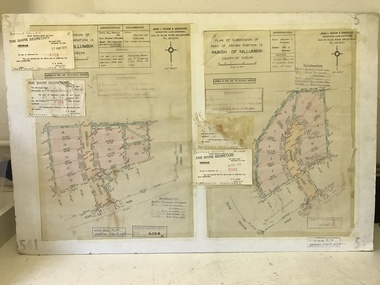
Planning Document, John Taylor & Assoc, Subdivision Plan # 541, Somerleigh Crescent and Rainham Close, Greenhills, 21/06/1971
... Planning Document...Subdivision Plan # 541, Somerleigh Crescent and Rainham Close, Greenhills. Planning Document John Taylor & Assoc. ...Plan of Subdivision at Somerleigh Crescent and Rainham Close, Greenhills.An example of hard copy subdivision plans from the Greensborough area. Mainly from the Shire of Diamond Valley era (1964-1994).Plan (2 sheets) mounted on heavy card.Stamped and handwritten Council permissions, dates and other details.subdivision plans, somerleigh crescent greensborough, rainham close greensborough -
 Greensborough Historical Society
Poster - Planning Document, City of Heidelberg, Subdivision Plan # G313, Corner Main and Grimshaw Streets, Greensborough, 08/03/1960
... Planning Document...Subdivision Plan # G313, Corner Main and Grimshaw Streets, Greensborough. Poster Planning Document City of Heidelberg ...Plan of Subdivision at corner of Main and Grimshaw Streets, Greensborough.An example of hard copy subdivision plans from the Greensborough area. Mainly from the Shire of Diamond Valley era (1964-1994).Plan (2 sheets) mounted on heavy card.Stamped and handwritten Council permissions, dates and other details.subdivision plans, main street greensborough, grimshaw street greensborough -
 Greensborough Historical Society
Book - Planning Document, TTM Consulting Pty Ltd, Greensborough District Centre: Structure plan, 1989, 1989_07
... Planning Document...Greensborough District Centre: Structure plan, 1989 Book Planning Document TTM Consulting Pty Ltd Shire of Diamond Valley Wilson Sayer Core Pty Ltd ...A summary of investigations into impacts of the Greensborough District Centre in 1989, with plans for the development of the East side of Main Street Greensborough.91 pages text and black and white line drawings. One colour fold out map. Black plastic binding and clear plastic cover. greensborough district centre, main street greensborough, greensborough plaza -
 Greensborough Historical Society
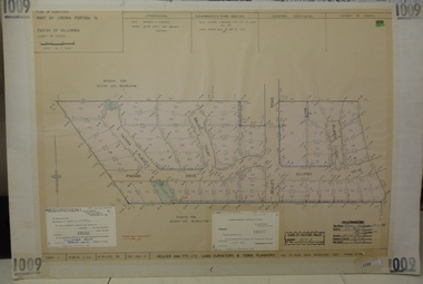
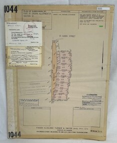
Poster - Planning Document, Shire of Diamond Valley et al, Subdivision Plan # 1044 - Parish of Nillumbik, County Bourke, Crown Allotment B Section 12, Eltham North, 1981-1987
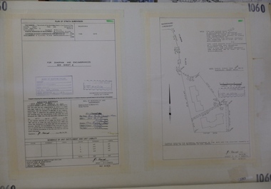
... Planning Document...Subdivision Plan # 1044 - Parish of Nillumbik, County Bourke, Crown Allotment B Section 12, Eltham North. Poster Planning Document Shire of Diamond Valley Fisher Cleeland Turner & Dwyer Vic ...Subdivision Plan # 1044 - Parish of Nillumbik, County Bourke, Crown Allotment B Section 12, Eltham North. This subdivision plan includes Weidlich Road and St Clems Street. The developer for this subdivision is Taunton Developments and the Surveyors are Fisher Cleeland Turner & Dwyer Vic, Surveyors and Engineers.An example of hard copy subdivision plans from the Greensborough area. Mainly from the Shire of Diamond Valley era (1964-1994).Plan (single sided) mounted on heavy card. Stamped and handwritten Council permissions, dates and other details. subdivision plans, shire of diamond valley, taunton developments -
 Greensborough Historical Society
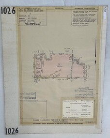
Poster - Planning Document, Shire of Diamond Valley et al, Subdivision Plan # 1026 - Parish of Nillumbik, County Bourke, Crown Allotment B Section 12, Eltham North, 1981-1984
... Planning Document...Subdivision Plan # 1026 - Parish of Nillumbik, County Bourke, Crown Allotment B Section 12, Eltham North. Poster Planning Document Shire of Diamond Valley Fisher Cleeland Turner & Dwyer Vic ...Subdivision Plan # 1026 - Parish of Nillumbik, County Bourke, Crown Allotment B Section 12, Eltham North. This subdivision plan includes Ryans Road (also known as Government Road) and St Clems Street. The developer for this subdivision is Taunton Developments and the Surveyors are Fisher Cleeland Turner & Dwyer Vic, Surveyors and Engineers.An example of hard copy subdivision plans from the Greensborough area. Mainly from the Shire of Diamond Valley era (1964-1994).Plan (single sided) mounted on heavy card. Stamped and handwritten Council permissions, dates and other details. subdivision plans, shire of diamond valley, taunton developments -
 Greensborough Historical Society
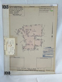
Poster - Planning Document, Shire of Diamond Valley et al, Subdivision Plan # 1018 - Parish of Nillumbik, County Bourke, Crown Allotment 4 Section 15, and Crown Allotment B Section 12, Eltham North, 1981-1982
... Planning Document...Subdivision Plan # 1018 - Parish of Nillumbik, County Bourke, Crown Allotment 4 Section 15, and Crown Allotment B Section 12, Eltham North. Poster Planning Document Shire of Diamond Valley Fisher Cleeland Turner & Dwyer Vic ...Subdivision Plan # 1018 - Parish of Nillumbik, County Bourke, Crown Allotment 4 Section 15, and Crown Allotment B Section 12, Eltham North. This subdivision plan includes Ryans Road (also known as Government Road) and St Clems Street. The developer for this subdivision is Taunton Developments and the Surveyors are Fisher Cleeland Turner & Dwyer Vic, Surveyors and Engineers.An example of hard copy subdivision plans from the Greensborough area. Mainly from the Shire of Diamond Valley era (1964-1994).Plan (single sided) mounted on heavy card. Stamped and handwritten Council permissions, dates and other details. subdivision plans, shire of diamond valley, taunton developments -
 Greensborough Historical Society
Poster - Planning Document, Shire of Diamond Valley, Subdivision Plan # G 1, Watsonia, 1962 and 1976
... Planning Document...Subdivision Plan # G 1, Watsonia Poster Planning Document Shire of Diamond Valley ...Plan of Subdivisions in Shire of Diamond Valley: Side 1: subdivision of LP5406 bounded by Plenty Road, Greensborough Road, Meakin Avenue, Watsonia and includes Aqueduct Road, 1976. Side 2: 2 plans - Keelbundoora: Morwell Avenue and Grace Street; Nillumbik: Inglis Street and Chute Street Diamond Creek, 1962An example of hard copy subdivision plans from the Greensborough area. Mainly from the Shire of Diamond Valley era (1964-1994).Plan (2 sided) mounted on heavy card. Contains 2 sheets pasted together.Stamped and handwritten Council permissions, dates and other details. subdivision plans, diamond creek, shire of diamond valley