Showing 210 items matching "plenty farm"
-
 Greensborough Historical Society
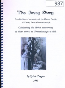
Book, The Davey Story; a collection of memories of the Davey Family of Plenty Farm, Greensborough; by Sylvia Tupper 2013, 1913-2013
... The Davey Story; a collection of memories of the Davey Family of Plenty Farm, Greensborough; by Sylvia Tupper 2013.......plenty farm...This history of the Davey Family of Plenty Farm Greensborough was published to celebrate the 100th anniversary of John Henry Davey, his wife Elizabeth and children settling in Greensborough in 1913. ...The Davey Story; a collection of memories of the Davey Family of Plenty Farm, Greensborough; by Sylvia Tupper 2013. ...This history of the Davey Family of Plenty Farm Greensborough was published to celebrate the 100th anniversary of John Henry Davey, his wife Elizabeth and children settling in Greensborough in 1913. The book contains stories written by many family members, photographs and traces the family line back to England in the 17th century.A thoroughly researched and referenced family history.108 pages, colour and black and white illustrations. Spiral binding. davey family, sylvia tupper, plenty farm, greensborough -
 Greensborough Historical Society
CD-ROM, The Davey story: a collection of memories of the Davey Family of Plenty Farm Greensborough, by Sylvia Tupper, 1913-2013
... The Davey story: a collection of memories of the Davey Family of Plenty Farm Greensborough, by Sylvia Tupper...This CD contains stories collected and published by Sylvia Tupper. davey family sylvia tupper CD-ROM in envelope The Davey story: a collection of memories of the Davey Family of Plenty Farm Greensborough, by Sylvia Tupper CD-ROM Sylvia Tupper (nee Davey) ...The Davey family came to live in Greensborough in 1913. This CD contains stories collected and published by Sylvia Tupper.CD-ROM in envelopedavey family, sylvia tupper -
 Greensborough Historical Society
Article, Greensborough Historical Society et al, Walter Bruce, 1914-1918
... At the time of Walter Bruce's enlistment, he was living at Plenty Farm and working for Mr John Davey....At the time of Walter Bruce's enlistment, he was living at Plenty Farm and working for Mr John Davey. world war 1 project walter bruce 1 Page, text and colour images. ...A short article about Walter Bruce and his service in World War 1. At the time of Walter Bruce's enlistment, he was living at Plenty Farm and working for Mr John Davey.1 Page, text and colour images.world war 1 project, walter bruce -
 Greensborough Historical Society
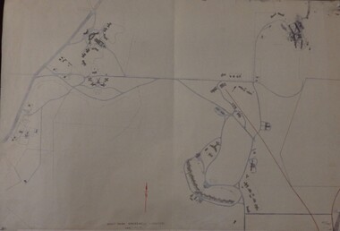
Maps, Mont Park, Gresswell, Larundel, 01/08/1949
... Map of Mont Park area, including Larundel, Gresswell and Kingsbury Farm, between Plenty Road and Waiora Road, as at 1949, including buildings. ...Greensborough Historical Society 34A Glenauburn Road Lower Plenty Lower Plenty melbourne Map of Mont Park area, including Larundel, Gresswell and Kingsbury Farm, between Plenty Road and Waiora Road, as at 1949, including buildings. mont park larundel gresswell watsonia kingsbury 49/147, R. ...Map of Mont Park area, including Larundel, Gresswell and Kingsbury Farm, between Plenty Road and Waiora Road, as at 1949, including buildings. Map of Mont Park area, including Larundel, Gresswell and Kingsbury Farm. Ink & pencil. Scale: 200': 1 inch49/147, R. G. H.mont park, larundel, gresswell watsonia, kingsbury -
 Greensborough Historical Society
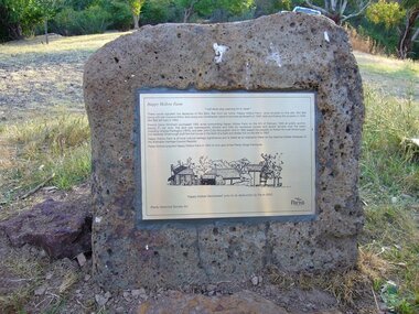
Photograph - Digital Image, Happy Hollow plaque, 05/02/1840o
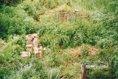
... plenty river...happy hollow...happy hollow farm...The land surrounding Happy Hollow farm at Plenty was purchased by Francis Wickham in 1840. ...Greensborough Historical Society 34A Glenauburn Road Lower Plenty Lower Plenty melbourne The land surrounding Happy Hollow farm at Plenty was purchased by Francis Wickham in 1840. ...The land surrounding Happy Hollow farm at Plenty was purchased by Francis Wickham in 1840. The land was later subdivided and held by various owners including Charles Partington (1875) and John McLaughlin who leased the property in 1892 to Robert Emmett Whatmough who erected the first dwelling on the property. The land was later owned by Mrs Betty Bell and was purchased by Parks Victoria in 1994 to form part of the Plenty Gorge Parklands. This plaque was laid by Plenty Historical Society.Happy Hollow was an example of early settlement along the Plenty River.Digital copy of colour photograph. Plaque at Plenty Gorge Parklands.plenty river, happy hollow, happy hollow farm, robert emmett whatmough, betty bell, john mclaughlin, charles partington, parks victoria -
 Warrnambool and District Historical Society Inc.
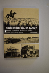
Book, StarPrinting Service Pty ltd, Soldiering On – Caramut and the Soldier Settler Movement, 2018
... Plenty of Possums’ produced in 1988 by the Caramut Bicentennial Group. The author, James Affleck, has produced several books dealing with local history in the Warrnambool area. This book is of considerable importance as it is a comprehensive record of the history of the post World War Two Soldier Settlement in the Caramut area. It will be very useful for local researchers. James Affleck, Peterborough Soldier Settlement, Caramut History of Warrnambool soldier settlement caramut This book records the history of the post World War Two soldier settlement farms ...This book records the history of the post World War Two soldier settlement farms in the Caramut area. Number two in a series of books on Soldier Settlements in Western Victoria.This is a soft cover book of 315 pages. It has a buff-coloured cover with black and white photographs and white printing on the front cover and black printing on the spine. The book includes printed material, black and white photographs, maps and plans. non-fiction This book records the history of the post World War Two soldier settlement farms in the Caramut area. Number two in a series of books on Soldier Settlements in Western Victoria.james affleck, peterborough, soldier settlement, caramut, history of warrnambool, soldier settlement, caramut -
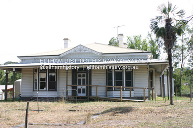
 Eltham District Historical Society Inc
Photograph - Digital Photograph, Marguerite Marshall, Stuchbery Farm dairy, 14 March 2008
... farm buildings...Yarrambat...Plenty...Stuchbery Farm was situated on the Plenty River bounded by Smugglers Gully to the north and La trobe Road, Yarrambat, to the east. ...Nillumbik Now and Then (Marshall-King) Collection Ada Stuchbery Alan Stuchbery dairy Stuchbery Farm farm buildings Yarrambat Plenty Gorge Park Born digital image file Stuchbery Farm dairy Photograph Digital Photograph Marguerite Marshall Marguerite Marshall Alan King ...Stuchbery Farm was situated on the Plenty River bounded by Smugglers Gully to the north and La trobe Road, Yarrambat, to the east. Alan and Ada Stutchbery moved to the valley in 1890, first living in a tent where four children were born. Alfred built a home and outbuildings around 1896. They planted an orchard, then a market garden and developed a dairy. Published: Nillumbik Now and Then / Marguerite Marshall 2008; photographs Alan King with Marguerite Marshall.; p179 The dramatic steep-sided Plenty Gorge lies along the divide of two geological areas, and separates the Nillumbik Shire and the City of Whittlesea. On the Nillumbik side are undulating hills and sedimentary rock, and in Whittlesea, lies a basalt plain formed by volcanic action up to two million years ago. This provides the Plenty Gorge Park with diverse vegetation and habitats, making it one of Greater Melbourne’s most important refuges for threatened and significant species. The park, established in 1986, consists of around 1350 hectares, and extends 11 kilometres along the Plenty River, from Greensborough to Mernda. It provides a wildlife corridor for around 500 native plant and 280 animal species. The area’s plentiful food and water attracted the Wurundjeri Aboriginal people and then European settlers. By 1837 squatters had claimed large runs of land for their sheep and cattle. The Plenty Valley was among the first in the Port Phillip District to be settled - mainly in the less heavily timbered west - and was proclaimed a settled district in 1841. But by the late 1880s, the settlers’ extensive land clearing for animal grazing, then agriculture, depleted the Wurundjeri’s traditional food sources, which helped to drive them away. Many Wurundjeri artefacts remain (now government protected), and so far 57 sites have been identified in the park, including scarred trees, burial areas and stone artefacts. Pioneer life could be very hard because of isolation, flooding, bushfires and bushrangers. Following the Black Thursday bushfires of 1851, basalt was quarried to build more fire-resistant homes. Gold discoveries in the early 1850s swelled the population, particularly around Smugglers Gully; but food production made more of an impact. In the late 1850s wheat production supplanted grazing. In the 1860s the government made small holdings available to poorer settlers. These had the greatest effect on the district, particularly in Doreen and Yarrambat, where orchards were established from the 1880s to 1914. Links with a prominent early family are the remains of Stuchbery Farm, by the river’s edge bounded by Smugglers Gully to the north and La Trobe Road, Yarrambat, to the east. The Stuchberys moved to the valley in 1890, and the family still lives in the area. In 1890, Alfred and Ada first lived in a tent where four children were born, then Alfred built the house and outbuildings around 1896. They planted an orchard, then a market garden, and developed a dairy. The family belonged to the local Methodist and tennis communities. Their grandson Walter, opened the Flying Scotsman Model Railway Museum in Yarrambat, which his widow, Vi, continues to run. Wal was also the Yarrambat CFA Captain for 22 years until 1987. Walter sold 24 hectares in 1976 for development - now Vista Court - and in 1990, the remaining 22.6 hectares for the park. Remaining are an early stone dairy and remnants of a stone barn, a pig sty and a well. Until it was destroyed by fire in 2003, a slab hut stood on the Happy Hollow Farm site, at the southern end of the park. The hut is thought to have been built in the Depression around 1893. This was a rare and late example of a slab hut with a domestic orchard close to Melbourne. Emmet Watmough and his family first occupied the hut, followed by a succession of families, until the Bell family bought it around 1948. There they led a subsistence lifestyle for 50 years, despite encroaching Melbourne suburbia. The Yellow Gum Recreation Area includes the Blue Lake, coloured turquoise at certain times of the year. Following the 1957 bushfires, this area was quarried by Reid Quarries Pty Ltd for Melbourne’s first skyscrapers, then by Boral Australia. However in the early 1970s water began seeping into the quarry forming the Blue Lake and the quarry was closed. The State Government bought the site in 1997 and opened it as a park in 1999.This collection of almost 130 photos about places and people within the Shire of Nillumbik, an urban and rural municipality in Melbourne's north, contributes to an understanding of the history of the Shire. Published in 2008 immediately prior to the Black Saturday bushfires of February 7, 2009, it documents sites that were impacted, and in some cases destroyed by the fires. It includes photographs taken especially for the publication, creating a unique time capsule representing the Shire in the early 21st century. It remains the most recent comprehenesive publication devoted to the Shire's history connecting local residents to the past. nillumbik now and then (marshall-king) collection, ada stuchbery, alan stuchbery, dairy, stuchbery farm, farm buildings, yarrambat, plenty gorge park -
 Eltham District Historical Society Inc
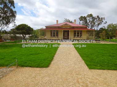
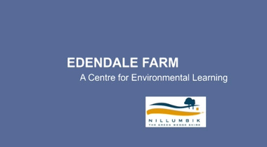
Photograph - Digital Photograph, Jim Connor, Edendale Farm Homestead, 11 December 2014
... Plenty. In 1896 Thomas Cool, Club Manager of the Victoria Coffee Palace in Melbourne purchased 7 acres of the original Stooke land and built the house now known as Edendale. Cool did not farm...Plenty. In 1896 Thomas Cool, Club Manager of the Victoria Coffee Palace in Melbourne purchased 7 acres of the original Stooke land and built the house now known as Edendale. Cool did not farm ...Edendale Farm is Nillumbik Shire Council's environment centre situated in Gastons Road, Eltham between the railway and the Diamond Creek. The homestead on the property was built in 1896 and is of historical significance, being the subject of a Heritage Overlay under the Nillumbik Planning Scheme. The Edendale property was originally part of an extensive land purchase in 1852 from the Crown by pioneer Eltham farmer Henry Stooke. He initially purchased 51 acres and later expanded his holdings by purchasing another three adjacent Crown allotments extending northerly from Josiah Holloway's Little Eltham subdivision. Despite clearing the land, Stooke did not build on this property, choosing to live on his property "Rosehill" at Lower Plenty. In 1896 Thomas Cool, Club Manager of the Victoria Coffee Palace in Melbourne purchased 7 acres of the original Stooke land and built the house now known as Edendale. Cool did not farm the land, instead using it as a gentleman’s residence, retiring to Eltham at weekends. In 1918 he purchased an additional 7 acres but in 1919 he sold the property. Later owners included J.W. Cox, the Gaston family and D. Mummery. In the 1980s the Eltham Shire Council purchased the site for use as a Council depot, but this use did not proceed. Subsequently, it was used as the Council pound. The Edendale Farm Pet Education and Retention Centre was established in the summer of 1988/1989 and was set up to replace the existing dog kennels with a high standard pet retention centre. The design style of the building was established to compliment the features of the existing house. It was equipped with 10 retention pens, a veterinary room and a pet education area where school children and other interested parties learnt about pet care procedures. It was later developed into a community farm and was run by an advisory committee and in 2000 it became an Environment Centre. In early 2006 an advisory committee was established for the development of a master plan for future development at Edendale Farm. The committee included Russell Yeoman, a former long-time shire planner and founding member of the Eltham District Historical Society. At the time of filming the Master Plan and future for Edendale was about continuing to develop Edendale as a centre of environment learning and looking at expanding displays and school program, running a lot more of life-long learning and workshops around sustainable living.jim connor collection, edendale community farm, edendale farm, eltham, gastons road -
 Eltham District Historical Society Inc
Photograph - Colour Print, Janefield, Bundoora, c.1982
... Plenty Road. He retired when the school closed around 1993. Mick pointed out the location of three remnant farm houses of the 1800s. ...Plenty Road. He retired when the school closed around 1993. Mick pointed out the location of three remnant farm houses of the 1800s. ...The photo encompasses what is present-day University Hill shopping complex and the Janefield Wetlands. Plenty Road is just visible to the left of the photo. Janefield was an area 18 km north-east of central Melbourne that is now part of Bundoora. In 1842 a flour mill, powered by the Plenty River, was built at Janefield, although the locality was not known by that name at that time. It seems that the name Springfield was used in the late 1840s, after a Springfield homestead, and this was changed to Janefield possibly upon the death of Jane Brock in 1847. She was the wife of James Brock, a local landowner and son of the purchaser of the flour mill. This photo is not strictly within the area of interest for EDHS but overlaps do occur at times with other Society’s interests through families and other associated connections. Eltham District Historical Society member (and Greensborough Historical Society member), Peter Van Eeken was undertaking research into this photo and approached the Local History Librarian at Yarra Plenty Regional Library to enquire about digitising the large print copy to facilitate research. Approaches were made to EDHS who had suitable facilities and were willing to accommodate and all parties agreed to add the image as part of their respective collections in partnership. Michael Lanigan, started work as a message boy at Mont Park when he left school at age 14. He worked his way up the system to become farm manager at Mont Park and Janefield Special School. He was one of the last people to drive a herd of cattle (in 1964) between the two locations along Plenty Road. He retired when the school closed around 1993. Mick pointed out the location of three remnant farm houses of the 1800s. The Brock House being the main one. Peter has been unable to find any photos of the Brock House, which what built in the late 1850s, severely burnt in the 1930s and demolished in the mid 1960s. The tree plantation along Plenty Road was established in 1930 and cut down in the mid 1980s. The Victorian Government established tree plantations at about 350 schools in the early 1930s. Briar Hill School had one but Peter is not sure about any other local schools having a tree plantation. Mick informed Peter that it was his job to remove the 14 acres of pine tree roots, after the trees were cut down (due to old age and an infestation of sap sucking insects). For Mick, this was an impossible job, so he arranged a contract, to house all the soil removed from works associated with the construction of the Greensborough Bypass, which needed temporary storage as it was too valuable, and would be great for use in road construction. The contract to store the soil was important to Mick, as the contract stipulated that when the soil was eventually removed, the tree roots had to be removed too. Which got rid of Mick's headache. Apparently, the huge mound of soil that covered the roots in the late 1980s could be seen from Briar Hill. Based on this, the photo is most likely to have been taken 1982 or 1983. The key to a final date is working out when the Board of Works Office opened but so far no information has come to light. (It was purchased by La Trobe University in 1991). The Office existed, or is hinted at, in the photo at the extreme north of the photo, opposite McKimmies Road, on the eastern side of Plenty Road. Photo on loan from Michael Lanigan via Peter Van Eeken. He cannot recall why it was taken. brock family, janefield, janefield drive, janefield wetlands, plenty road, university hill -
 Eltham District Historical Society Inc
Photograph, Ruins of Coulstocks Mill, Janefield, South Morang
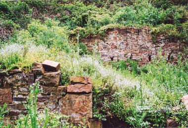
... Mill Park Farm at Janefield on the Plenty River was established around 1840 by George Coulstock where he grew wheat. ...Eltham District Historical Society Inc 728 Main Rd Eltham melbourne Mill Park Farm at Janefield on the Plenty River was established around 1840 by George Coulstock where he grew wheat. ...Mill Park Farm at Janefield on the Plenty River was established around 1840 by George Coulstock where he grew wheat. His flour mill was one of the first in Victoria, under construction as early as 1841. After bushfires and Coulstock's early death in 1842, the farm and its mill were taken over by local landowners Henry Miller and John Brock. Peter Hurlestone took charge of the mill. With water diverted from the Plenty River to fill the newly built Yan Yean Reservoir which opened in 1857, the Hurlestone family quit and that was the demise of the mill.Four colour photographs showing the ruins of Coulstocks Flour Mill (Janefield Mill), Janefield. 1. Stone wall 2. Old mill 3. Stone remains of old mill 4. Tree near old mill sitemills, flour mills, coulstock, janefield, plenty river, ruins, stone walls, plenty gorge, bundoora -
 Eltham District Historical Society Inc
Photograph, Ruins of Coulstocks Mill, Janefield, South Morang
... Mill Park Farm at Janefield on the Plenty River was established around 1840 by George Coulstock where he grew wheat. ...Eltham District Historical Society Inc 728 Main Rd Eltham melbourne Mill Park Farm at Janefield on the Plenty River was established around 1840 by George Coulstock where he grew wheat. ...Mill Park Farm at Janefield on the Plenty River was established around 1840 by George Coulstock where he grew wheat. His flour mill was one of the first in Victoria, under construction as early as 1841. After bushfires and Coulstock's early death in 1842, the farm and its mill were taken over by local landowners Henry Miller and John Brock. Peter Hurlestone took charge of the mill. With water diverted from the Plenty River to fill the newly built Yan Yean Reservoir which opened in 1857, the Hurlestone family quit and that was the demise of the mill.Five colour photographs of ruins of Coulstocks Mill, Janefield (Mill Park - Bundoora)mills, flour mills, coulstock, janefield, plenty river, ruins, stone walls, bundoora, plenty gorge -
 Eltham District Historical Society Inc
Folder, James Johnston
... Arriving in Melbourne in 1840, and spending twelve months on the Plenty, and another similar period on the Darebin Creek, he went in 1842, to the Kangaroo Ground, where he rented a farm from Mr Donaldson for seven years, subsequently purchasing 160 acres of land from the Government at one pound 13s per acre, and also owning 60 acres adjoining, where he carries on farming. ...Arriving in Melbourne in 1840, and spending twelve months on the Plenty, and another similar period on the Darebin Creek, he went in 1842, to the Kangaroo Ground, where he rented a farm from Mr Donaldson for seven years, subsequently purchasing 160 acres of land from the Government at one pound 13s per acre, and also owning 60 acres adjoining, where he carries on farming. ..."Johnston, James - Kangaroo Ground, is a scotchman by birth, born in Aberdeenshire in 1812. Arriving in Melbourne in 1840, and spending twelve months on the Plenty, and another similar period on the Darebin Creek, he went in 1842, to the Kangaroo Ground, where he rented a farm from Mr Donaldson for seven years, subsequently purchasing 160 acres of land from the Government at one pound 13s per acre, and also owning 60 acres adjoining, where he carries on farming. Mr Johnston has a family of three sons and four daughters." Sutherland, Alexander Victoria and its Metropolis, v.2 1888 page 434. Folder of information on James Johnston, Kangaroo Ground pioneerjames johnston, pioneer, kangaroo ground -
 Eltham District Historical Society Inc
Film - Video (DVD), Nillumbik Shire Council, Edendale Farm Community Environment Centre: History, c.2009
... Plenty. In 1896 Thomas Cool, Club Manager of the Victoria Coffee Palace in Melbourne purchased 7 acres of the original Stooke land and built the house now known as Edendale. Cool did not farm...Plenty. In 1896 Thomas Cool, Club Manager of the Victoria Coffee Palace in Melbourne purchased 7 acres of the original Stooke land and built the house now known as Edendale. Cool did not farm ...EDENDALE FARM Edendale Farm is Nillumbik Shire Council's environment centre situated in Gastons Road, Eltham between the railway and the Diamond Creek. The homestead on the property was built in 1896 and is of historical significance, being the subject of a Heritage Overlay under the Nillumbik Planning Scheme. The Edendale property was originally part of an extensive land purchase in 1852 from the Crown by pioneer Eltham farmer Henry Stooke. He initially purchased 51 acres and later expanded his holdings by purchasing another three adjacent Crown allotments extending northerly from Josiah Holloway's Little Eltham subdivision. Despite clearing the land, Stooke did not build on this property, choosing to live on his property "Rosehill" at Lower Plenty. In 1896 Thomas Cool, Club Manager of the Victoria Coffee Palace in Melbourne purchased 7 acres of the original Stooke land and built the house now known as Edendale. Cool did not farm the land, instead using it as a gentleman’s residence, retiring to Eltham at weekends. In 1918 he purchased an additional 7 acres but in 1919 he sold the property. Later owners included J.W. Cox, the Gaston family and D. Mummery. In the 1980s the Eltham Shire Council purchased the site for use as a Council depot, but this use did not proceed. Subsequently, it was used as the Council pound. The Edendale Farm Pet Education and Retention Centre was established in the summer of 1988/1989 and was set up to replace the existing dog kennels with a high standard pet retention centre. The design style of the building was established to compliment the features of the existing house. It was equipped with 10 retention pens, a veterinary room and a pet education area where school children and other interested parties learnt about pet care procedures. It was later developed into a community farm and was run by an advisory committee and in 2000 it became an Environment Centre. In early 2006 an advisory committee was established for the development of a master plan for future development at Edendale Farm. The committee included Russell Yeoman, a former long-time shire planner and founding member of the Eltham District Historical Society. At the time of filming the Master Plan and future for Edendale was about continuing to develop Edendale as a centre of environment learning and looking at expanding displays and school program, running a lot more of life-long learning and workshops around sustainable living.edendale community farm, eltham, gastons homestead, gastons road, shire of nillumbik, video recording -
Eltham District Historical Society Inc
Document - Folder, Macmillan, Donald
... Plenty River property of Captain Aneas McPerson, under the manager Thomas Walker. MacMillan married again and son Hugh was born 1860, first of another six children. They lived at Morang but, in 1866, selected land at Arthurs Creek. Hugh and his sister Ann attended the Hazel Glen School. Later Hugh carried mail from South Yan Year (now Mernda) to Arthurs Creek School (also the post office); he was Sunday School teacher at the Arthurs Creek Methodist Church. Hugh married Helena Heatley from New Zealand who managed the farm...Plenty River property of Captain Aneas McPerson, under the manager Thomas Walker. MacMillan married again and son Hugh was born 1860, first of another six children. They lived at Morang but, in 1866, selected land at Arthurs Creek. Hugh and his sister Ann attended the Hazel Glen School. Later Hugh carried mail from South Yan Year (now Mernda) to Arthurs Creek School (also the post office); he was Sunday School teacher at the Arthurs Creek Methodist Church. Hugh married Helena Heatley from New Zealand who managed the farm ...Donald MacMillan (widower) with his six children eft Inverness, Scotland, in 1849, and worked as a shepherd on Plenty River property of Captain Aneas McPerson, under the manager Thomas Walker. MacMillan married again and son Hugh was born 1860, first of another six children. They lived at Morang but, in 1866, selected land at Arthurs Creek. Hugh and his sister Ann attended the Hazel Glen School. Later Hugh carried mail from South Yan Year (now Mernda) to Arthurs Creek School (also the post office); he was Sunday School teacher at the Arthurs Creek Methodist Church. Hugh married Helena Heatley from New Zealand who managed the farm after Hugh died, growing fruit and vegetables, carted by wagon to the Victoria Market. Their firstborn was Ken. Contents Newspaper article: "Donald MacMillan - a romantic", Diamond Valley News, 29 October 1985, pp30-31; history of MacMillan family. Newspaper article: "An alternative road to happiness", Diamond Valley News, 29 October 1985, p29; Mic Webb's travels and philosophy, now living at Hurstbridge.Newspaper clippings, A4 photocopies, etcdonald macmillan, plenty river victoria, captain aneas mcpherson, thomas walker, morang victoria, arthurs creek victoria, ann macmillan, hazel glen school victoria, south yan yean victoria, mernda victoria, arthurs creek school victoria, arthurs creek methodist church, malcolm macmillan, helena macmillan nee heatley, ken macmillan, mic webb, hurstbridge learning co-op, hurstbridge victoria, cottlesbridge victoria, st andrews victoria -
 Eltham District Historical Society Inc
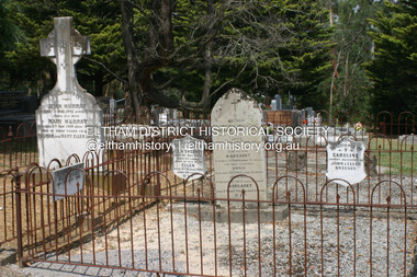
Photograph - Digital Photograph, Alan King, Graves of Thomas Sweeney and family, Eltham Cemetery, Victoria, 27 January 2008
... Plenty River and the establishment of a school at Eltham. Roman Catholic Church services were held at Culla Hill in the early years. When he died in 1867, he was regarded as a respected member of the community. Thomas and Margaret are buried in Eltham Cemetery with many of their descendants. Their first son John continued to farm...Plenty River and the establishment of a school at Eltham. Roman Catholic Church services were held at Culla Hill in the early years. When he died in 1867, he was regarded as a respected member of the community. Thomas and Margaret are buried in Eltham Cemetery with many of their descendants. Their first son John continued to farm ...The grave of Thomas Sweeney, former convict turned respectable citizen. The Murray and Sweeney families were both early settlers of the Eltham district and connected by marriage. Their family plots are located side by side in the Catholic section of the Eltham Cemetery. Irish-born Thomas Sweeney is regarded as the first settler in Eltham. He was transported to Sydney in 1823 after being convicted of arson. He was granted his freedom in 1838 and married Margaret Meehan in the same year. They moved to Melbourne and in 1842 Thomas purchased 110 acres beside the Yarra River in the vicinity of present-day Sweeneys Lane. He called the property ‘Culla Hill’ and built a small slab hut (reputedly with Wurundjeri help; Margaret is said to have run an informal hospital for them in return). This was followed in 1846 by more substantial buildings consisting of a three-roomed Irish-style ‘longhouse’ and a barn made of stone and handmade bricks, with doors large enough to accommodate a fully loaded wagon. When the gold rush came, Thomas prospered by selling meat and potatoes to the prospectors, enabling him to purchase a further 308 acres in 1856. He promoted the construction of a bridge over the Plenty River and the establishment of a school at Eltham. Roman Catholic Church services were held at Culla Hill in the early years. When he died in 1867, he was regarded as a respected member of the community. Thomas and Margaret are buried in Eltham Cemetery with many of their descendants. Their first son John continued to farm Culla Hill until his death in 1909. Culla Hill passed out of the Sweeneys' possession in 1939. The house and barn remain today, though lesser outbuildings have gone. The facade of the house is much the same as it was in the 1840s. Sacred To the memory of Thomas Sweeney Who died Sep 6th 1867 Aged 65 years May his soul res in peace Also his wife Margaret Died Oct 3rd 1884 aged 73 years And their daughters Annie Died Aug 22nd 1860 aged 21 years Johanna Died Aug 19th 1872 aged 22 years Margaret Died 7th Sep 1913 aged 72 years R.I.P. Also In Memory Of John Sweeney Died 24th May 1909 Aged 65 years Also of his wife Ellen Died 8th March 1910 Aged 64 years R.I.P Also In Memory Of Caroline Infant daughter of John & Ellen Sweeney Published: Nillumbik Now and Then / Marguerite Marshall 2008; photographs Alan King with Marguerite Marshall.; p55 From the piety and poverty of 19th century Eltham, 20th century artists and environmentalists, to today’s comfortable middle class, Eltham Cemetery records it all — and more. A visit to Eltham Cemetery reveals an important social record since its beginnings in 1858. The cemetery was situated on about six acres (2.4ha) (now around 4.8ha) at the corner of Mount Pleasant and Metery Roads.1* It is thought that Metery Road was originally called Cemetery Road, but in the early 1940s, a resident, possibly a councillor, objected to the name resulting in the change.2 Much can be gleaned about the developing Eltham community from burial styles and the names of former local residents. Originally the cemetery was divided into Christian denominations, like others of that time, following the United Kingdom burial system. In 1861 the cemetery included Church of England, Presbyterian, Roman Catholic and Wesleyans (later Methodist) sites. Graves also indicated social class. Some had grand tombstones, perhaps fenced with ornamental cast iron railing, but most in the 1860s and 1870s were constructed of modest stone slabs.3 This indicated the poverty of the district, which was largely inhabited by farmers on small landholdings. A poignant reminder of the high rates of infant mortality of those times, are the many infants and young children recorded on the headstones. Major changes occurred in the cemetery in the late 20th century as Christian adherence weakened and society became more egalitarian and informal. In the early 1970s a non-denominational lawn section for burials was established. Since then all new areas have been non-denominational to accommodate the more diverse local community. Now, instead of large ornamental headstones, some mourners have chosen boulders, reflecting the natural Eltham style, while others choose graves in the lawn areas or niches in walls. In the late 1970s, the University Donor Section was established north-west of Candlebark Lawn for those who donated their bodies for The University of Melbourne medical research. In the early 1980s the natural Australian garden style, popular in Eltham, was mirrored in a new section called Ashes Walk. Local landscape architect Gordon Ford, who had popularised this style, designed the Walk using boulders shaded by native plants beside curved pathways. Landscape architect Robert Boyle later redesigned Ashes Walk and developed other parts of the cemetery in keeping with this style.4 Appropriately Ford, who died in 1999, was interred in the Native Garden Section in a cluster of sites shaded by a large eucalyptus tree.5 By 2007, about 6400 interments were recorded in the Eltham Cemetery. Close inspection reveals notable names in the district’s history. The grave of Thomas Sweeney, a former convict who became a respected citizen, can be found in the Roman Catholic section near the path. Eltham Primary School’s first headmaster, David Clark, is buried in a modest grave in the Church of England section to the east of the path from the main entrance. Sir William Irvine, Victorian Premier from 1900 to 1902, whose grave is in the north-east Presbyterian section was at various times Victoria’s Chief Justice, Deputy Governor and Treasurer.6 Further south is the grave of social reformer Bertram Wainer, born in Scotland in 1928 and died in 1987. He campaigned to legalise abortion and exposed police corruption in allowing illegal ‘backyard’ abortions. Other prominent local residents interred in the cemetery include: Justus Jörgensen, who founded Montsalvat; Alistair Knox, the mud-brick housing pioneer and Eltham Shire Councillor from 1971 to 1975 and President in 1975; Clem and Nina Christensen, who had a major influence on the literary development of post World War Two Australia. Others were: composer Dorian Le Gallienne; artist Peter Glass; Stephen Dattner, a prominent Melbourne furrier; ALP parliamentarian for Greensborough, Pauline Toner and political scientist and commentator, Professor William Macmahon Ball.This collection of almost 130 photos about places and people within the Shire of Nillumbik, an urban and rural municipality in Melbourne's north, contributes to an understanding of the history of the Shire. Published in 2008 immediately prior to the Black Saturday bushfires of February 7, 2009, it documents sites that were impacted, and in some cases destroyed by the fires. It includes photographs taken especially for the publication, creating a unique time capsule representing the Shire in the early 21st century. It remains the most recent comprehenesive publication devoted to the Shire's history connecting local residents to the past. nillumbik now and then (marshall-king) collection, annie sweeney, caroline sweeney, ellen sweeney, eltham cemetery, graves, gravestones, johanna sweeney, john murray, john sweeney, margaret sweeney, mary ellen drain, mary murray, thomas murray, thomas sweeney -
 Eltham District Historical Society Inc
Photograph - Digital Photograph, Alan King, Edendale Farm Homestead, 29 January 2008
... Plenty. In 1896 Thomas Cool, Club Manager of the Victoria Coffee Palace in Melbourne purchased 7 acres of the original Stooke land and built the house now known as Edendale. Cool did not farm...Plenty. In 1896 Thomas Cool, Club Manager of the Victoria Coffee Palace in Melbourne purchased 7 acres of the original Stooke land and built the house now known as Edendale. Cool did not farm ...Edendale Farm is Nillumbik Shire Council's environment centre situated in Gastons Road, Eltham between the railway and the Diamond Creek. The homestead on the property was built in 1896 and is of historical significance, being the subject of a Heritage Overlay under the Nillumbik Planning Scheme. The Edendale property was originally part of an extensive land purchase in 1852 from the Crown by pioneer Eltham farmer Henry Stooke. He initially purchased 51 acres and later expanded his holdings by purchasing another three adjacent Crown allotments extending northerly from Josiah Holloway's Little Eltham subdivision. Despite clearing the land, Stooke did not build on this property, choosing to live on his property "Rosehill" at Lower Plenty. In 1896 Thomas Cool, Club Manager of the Victoria Coffee Palace in Melbourne purchased 7 acres of the original Stooke land and built the house now known as Edendale. Cool did not farm the land, instead using it as a gentleman’s residence, retiring to Eltham at weekends. In 1918 he purchased an additional 7 acres but in 1919 he sold the property. Later owners included J.W. Cox, the Gaston family and D. Mummery. In the 1980s the Eltham Shire Council purchased the site for use as a Council depot, but this use did not proceed. Subsequently, it was used as the Council pound. The Edendale Farm Pet Education and Retention Centre was established in the summer of 1988/1989 and was set up to replace the existing dog kennels with a high standard pet retention centre. The design style of the building was established to compliment the features of the existing house. It was equipped with 10 retention pens, a veterinary room and a pet education area where school children and other interested parties learnt about pet care procedures. It was later developed into a community farm and was run by an advisory committee and in 2000 it became an Environment Centre. In early 2006 an advisory committee was established for the development of a master plan for future development at Edendale Farm. The committee included Russell Yeoman, a former long-time shire planner and founding member of the Eltham District Historical Society. At the time of filming the Master Plan and future for Edendale was about continuing to develop Edendale as a centre of environment learning and looking at expanding displays and school program, running a lot more of life-long learning and workshops around sustainable living. Covered under Heritage Overlay, Nillumbik Planning Scheme. Published: Nillumbik Now and Then / Marguerite Marshall 2008; photographs Alan King with Marguerite Marshall.; p101 A sharp turn from busy Wattletree Road by the railway line, brings a surprise. Only 1.4 km from Eltham’s centre, sheep feed, blissfully unaware of the hectic suburban activity so close by. At the entrance to the 5.6ha Edendale Farm is another surprise. A work of art that looks like huge tree trunks transformed into bowler and top-hatted men. The Fences Act 1968 by Tony Trembath with Mark Cain and John Doyle, 1996, is classified by the National Trust of Australia as having Regional Significance. The title refers to a government act on disputes between neighbors over the placement of fences and boundaries. This takes a ‘wry swipe’ at a community divided by trivial squabbles. It also celebrates making do with limited resources.1 Further along on the left, the office wall is decorated with a massive Eltham Copper Butterfly, designed by Robert Tickner and made by school children with used plastic bottles and other waste material. Nillumbik Council runs Edendale as an Environmental Education Centre, to help preserve and enhance the local environment. As early as 1988 the former Eltham Shire Council realised Edendale’s importance in meeting people’s needs, particularly of children, to enjoy farmland. The centre, with the Eltham North Reserve to the north - including remnant bushland and open parkland - makes up the major part of the public open space for this area. The council considers this area will become increasingly important to the local community for recreational use.2 Educational programs aim to encourage community involvement to ensure the long-term rehabilitation and protection of natural bushland areas. Edendale is used by people of all ages - from school children to adults - for environmental programs and workshops, as well as for recreation, to enjoy the domestic animals and to picnic. Edendale is also home to the Environmental Works staff who manage reserves and roadsides and support Nillumbik Friends environmental groups. The Friends propagate plants at the nursery, which grows indigenous plants and sells these to the public.3 The centre demonstrates the sustainable living the farm teaches, with features like solar hot water and drive lighting and for the fireplace, logs of recycled cardboard. Edendale has had a varied history as a dog pound and even as a retreat for Thomas Cool, Club Manager of the Victoria Coffee Palace in Melbourne. His single-storey weatherboard house built in 1896, which still stands, was grander than most homes in Eltham. Although such buildings were common in many other parts of Melbourne, Eltham’s poverty and remoteness did not encourage such construction. The Victorian rectangular-shaped house, with a corrugated iron roof and veranda, has elegant large rooms, leadlight windows, ceiling roses, two bay windows and ornately carved wooden fireplace surrounds. Cool bought seven acres (2.8ha) from pioneer Eltham farmer Henry Stooke’s 200 acre (81ha) farm, which he had bought from the Crown in 1852. In 1918 Cool bought an extra seven acres (2.8ha) but in 1919 sold the estate to farmer John Cox. In 1933 Cox sold Edendale to Mrs Elizabeth Gaston, after whom the road leading to the centre was named. The property was owned by several Gaston family members, who called it Edendale, then by a police constable, Douglas Mummery, until the Shire of Eltham bought it in 1970. Oddly Edendale was known as Mummery’s for almost 20 years, although Mummery owned it only for a short time.4 The shire used Edendale as a dog pound until amalgamation with other municipalities in 1996. The pound then moved to the Yan Yean Road, Plenty site, which had been used by the former Diamond Valley Shire Council. To the west and north the centre is bounded by Diamond Creek and on the east by the Melbourne-Hurstbridge railway line. Part of the Research creek forms the centre’s southern boundary.This collection of almost 130 photos about places and people within the Shire of Nillumbik, an urban and rural municipality in Melbourne's north, contributes to an understanding of the history of the Shire. Published in 2008 immediately prior to the Black Saturday bushfires of February 7, 2009, it documents sites that were impacted, and in some cases destroyed by the fires. It includes photographs taken especially for the publication, creating a unique time capsule representing the Shire in the early 21st century. It remains the most recent comprehenesive publication devoted to the Shire's history connecting local residents to the past. nillumbik now and then (marshall-king) collection, edendale farm -
![Photograph - Digital image, Robert Partington [cropped from family portrait], 31/01/1857](/media/collectors/4f729f5697f83e03086015b8/items/58104e5bd0cdd1266096d94f/item-media/58104e91d0cdd1266096f300/item-fit-380x285.jpg?cb=6) Greensborough Historical Society
Greensborough Historical SocietyPhotograph - Digital image, Robert Partington [cropped from family portrait], 31/01/1857
... Charles Partington and family came to Melbourne in the 1857and moved to Greensborough where they farmed along the Plenty River. Descendants still live in Greensborough. ...Greensborough Historical Society 34A Glenauburn Road Lower Plenty Lower Plenty melbourne Portrait of Robert Partington cropped from family photograph. Charles Partington and family came to Melbourne in the 1857and moved to Greensborough where they farmed along the Plenty River. ...Portrait of Robert Partington cropped from family photograph. Charles Partington and family came to Melbourne in the 1857and moved to Greensborough where they farmed along the Plenty River. Descendants still live in Greensborough. A pioneer Greensborough family.Digital copy of cropped sections of black and white studio photograph.robert partington -
 Greensborough Historical Society
Photograph - Digital Image, Benjamin Partington, 1899c
... Charles Partington and family came to Melbourne in the 1840s and moved to Greensborough where they farmed along the Plenty River. Descendants still live in Greensborough. ...Unidentified photograph, (Verified to by Faye Partington that it Benjamin (born at Point Lookout). Lived and worked at Willis Vale on the farm and orchards. Married at age 34.Charles Partington and family came to Melbourne in the 1840s and moved to Greensborough where they farmed along the Plenty River. Descendants still live in Greensborough.Digital copy of black and white studio photograph. -
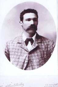
 Greensborough Historical Society
Article, Greensborough Historical Society et al, Bruce Alexander Pope, 1914-1918
... Greensborough Historical Society 34A Glenauburn Road Lower Plenty Lower Plenty melbourne A short article about Bruce Alexander Pope and his service in World War 1. At the time of his enlistment he was living at Diamond Creek. Bruce Pope farmed ...A short article about Bruce Alexander Pope and his service in World War 1. At the time of his enlistment he was living at Diamond Creek. Bruce Pope farmed in the Greensborough area post-war.One page, text and colour images.world war 1 project, bruce alexander pope -
 Greensborough Historical Society
Article, De Henzell Storey, 23/12/1920
... Greensborough Historical Society 34A Glenauburn Road Lower Plenty Lower Plenty melbourne Death notice (Argus) and short obituary (The Age) of De Henzell Storey, Real Estate agent in Sandringham, who had a farm in Research and died 23 December 1920. ...Death notice (Argus) and short obituary (The Age) of De Henzell Storey, Real Estate agent in Sandringham, who had a farm in Research and died 23 December 1920. He and his wife are buried at St Helena Cemetery.2 p. text and photographs.de henzell storey, st helena cemetery -
 Greensborough Historical Society
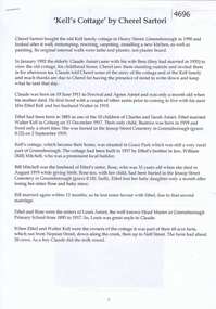
Article, Cherel Sartori, Kell's Cottage by Cherel Sartori, 1917o
... Greensborough Historical Society 34A Glenauburn Road Lower Plenty Lower Plenty melbourne Story of Kell's Cottage, built 1917, at 112 Henry Street Greensborough by William Mitchell on the 60 acre dairy farm owned by Ethel and Walter Kell. ...Story of Kell's Cottage, built 1917, at 112 Henry Street Greensborough by William Mitchell on the 60 acre dairy farm owned by Ethel and Walter Kell. This account was written by Cherel Sartori (who owned the house from 1990-2000), following a visit by Claude Amiet who lived in the house as a child in the early 20th century.12 p., text and sepia and col. photographskell's cottage, claude amiet, cherel sartori -
 Greensborough Historical Society
Photograph - Digital Image, Art at WaterMarc, July 2017, 22/07/2017
... Plenty melbourne Photographs of an art installation by Jessie Stanley at WaterMarc Greensborough on 22/07/2017. From Jessie Stanley's FaceBook page :Dust to Dust is complete... It's an ephemeral site-specific work about how the Melbourne suburb of Greensborough has transformed over time. This area's exceptionally fertile soil [used by] by white settlers for farms ...Photographs of an art installation by Jessie Stanley at WaterMarc Greensborough on 22/07/2017. From Jessie Stanley's FaceBook page :Dust to Dust is complete... It's an ephemeral site-specific work about how the Melbourne suburb of Greensborough has transformed over time. This area's exceptionally fertile soil [used by] by white settlers for farms, market gardens and orchards reshaped the Wurundjeri's traditional lands - and today the private sale and division of these farms informs the streetscape and town plan. With soil sourced locally this work reveals some of the area’s history - the text running around the perimeter was written by former resident Val Wilson, a snippet of her recollections of growing up in the area in the 1950s. The arrows and text act like a compass to orientate this site with greater Melbourne. On display in the lobby of Banyule Council until chance, time (or a broom) sweeps it away, Many thanks to Banyule City Council, Greensborough Historical Society and Valerie Wilson. "An artistic representation of Greensborough's history.Digital photographs of art installation.jessie stanley, watermarc, greensborough historical society, banyule council -
 Greensborough Historical Society
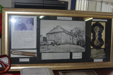
Photograph - Digital Image, Marilyn Smith, Happy Hollow Farm, framed memorabilia, 24/06/2017
... Plenty melbourne A photograph taken at the June 24 2017 meeting of Greensborough Historical Society. This framed collection of Happy Hollow memorabilia is owned by Jacinta Crealy. greensborough historical society jacinta crealy robert whatmough happy hollow farm Digital copy of colour photograph Happy Hollow Farm, framed memorabilia Photograph - Digital Image Marilyn Smith ...A photograph taken at the June 24 2017 meeting of Greensborough Historical Society. This framed collection of Happy Hollow memorabilia is owned by Jacinta Crealy.Digital copy of colour photographgreensborough historical society, jacinta crealy, robert whatmough, happy hollow farm -
 Greensborough Historical Society
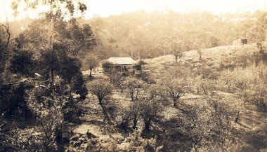
Photograph - Digital image, Happy Hollow 1934, 1840o
... Greensborough Historical Society 34A Glenauburn Road Lower Plenty Lower Plenty melbourne Photographs of Happy Hollow Farm in as a bark hut in the 19th century and a cottage the early 20th century(circa 1934). robert emmett whatmough parks victoria happy hollow farm Digital copies of 2 views of Happy Hollow Farm.. ...Photographs of Happy Hollow Farm in as a bark hut in the 19th century and a cottage the early 20th century(circa 1934). Digital copies of 2 views of Happy Hollow Farm..robert emmett whatmough, parks victoria, happy hollow farm -
 Greensborough Historical Society
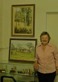
Photograph - Digital Image, June Hall with paintings by Doug Hall, 16/02/2017
... Greensborough Historical Society 34A Glenauburn Road Lower Plenty Lower Plenty melbourne GHS member June Hall is photographed with 2 paintings by her late husband Doug Hall. June donated these paintings to the Greensborough Historical Society. One of the paintings if of Oldstead Farm ...GHS member June Hall is photographed with 2 paintings by her late husband Doug Hall. June donated these paintings to the Greensborough Historical Society. One of the paintings if of Oldstead Farm house that was sited at Oldstead Road Greensborough..Paintings are of the local area.Digital copy of colour photographsgreensborough historical society, june hall nee evans, doug hall -
 Greensborough Historical Society
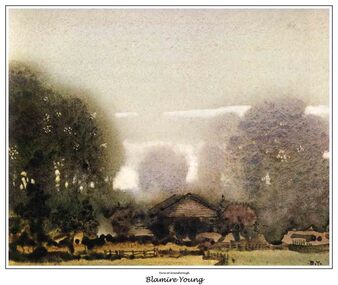
Painting - Digital image, Farm at Greensborough, by Blamire Young, 1907_
... Greensborough Historical Society 34A Glenauburn Road Lower Plenty Lower Plenty melbourne A photograph of a painting of a farm at Greensborough, around 1907, by Blamire Young. greensborough blamire young Colour photograph of painting. ...A photograph of a painting of a farm at Greensborough, around 1907, by Blamire Young.Colour photograph of painting.greensborough, blamire young -
 Greensborough Historical Society
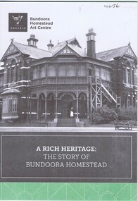
Pamphlet, City of Darebin, A Rich heritage: the story of Bundoora Homestead, 2016_
... Greensborough Historical Society 34A Glenauburn Road Lower Plenty Lower Plenty melbourne History of Bundoora Homestead, from its initial use by John Matthew Vincent Smith as a horse and cattle stud, and later as a convalescent farm and repatriation hospital until its ownership by Darebin City Council and restoration. bundoora homestead 10 p. pamphlet, col. & black & white photographs and plans A Rich heritage: the story of Bundoora Homestead Pamphlet Bundoora Homestead Art Centre City of Darebin ...History of Bundoora Homestead, from its initial use by John Matthew Vincent Smith as a horse and cattle stud, and later as a convalescent farm and repatriation hospital until its ownership by Darebin City Council and restoration.10 p. pamphlet, col. & black & white photographs and plansbundoora homestead -
 Greensborough Historical Society
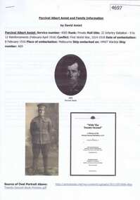
Document, David Amiet et al, Percival Albert Amiet and family information, by David Amiet, 1881o
... Greensborough Historical Society 34A Glenauburn Road Lower Plenty Lower Plenty melbourne Information supplied by Richard Gary Amiet to David Amiet, who compiled this document. Includes Percival Albert Amiet's war service in 1916. His son Claude by his first marriage was brought up by his sister Ethel at a dairy farm in Greensborough. amiet family percival albert amiet 5 pages, black and white print, black and white and colour photographs. ...Information supplied by Richard Gary Amiet to David Amiet, who compiled this document. Includes Percival Albert Amiet's war service in 1916. His son Claude by his first marriage was brought up by his sister Ethel at a dairy farm in Greensborough.5 pages, black and white print, black and white and colour photographs.amiet family, percival albert amiet -
 Greensborough Historical Society
Document, Miles Lewis, Happy Hollow farm: File note, by Miles Lewis, 1994_
... Greensborough Historical Society 34A Glenauburn Road Lower Plenty Lower Plenty melbourne This is a File note written by Professor Miles Lewis, of Faculty of Architecture, University of Melbourne on Happy Hollow Farm, reputed to be the home of Emmett Whatmough and his family and subsequently by Charles Partington and his family and at time of compilation (1994) home of Dr. ...This is a File note written by Professor Miles Lewis, of Faculty of Architecture, University of Melbourne on Happy Hollow Farm, reputed to be the home of Emmett Whatmough and his family and subsequently by Charles Partington and his family and at time of compilation (1994) home of Dr. Christopher Bell. His examination was intended to assist in determining the age of the building, with a view to seeing whether it be nominated for inclusion on the Historic Buildings Register5 page photocopy of typescript, with house plan.happy hollow farm, christopher bell, whatmough, partington, betty bell -
 Greensborough Historical Society
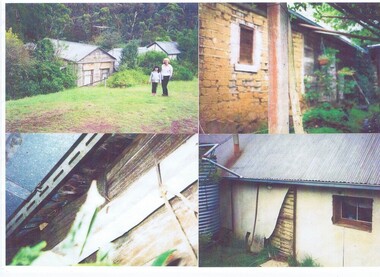
Photograph - Digital image, Happy Hollow, 1892o
... Plenty melbourne Robert Emmett Whatmough leased the Happy Hollow site from John Cully McLaughlin in 1892 and built a bark house there. This was retained by later owners, the Bell family. Original photographs were taken prior to 2003, as the building was destroyed by fire in 2003 whatmough family happy hollow farm bell family Copies of four coloured photographs on one page Happy Hollow Photograph - Digital image ...Robert Emmett Whatmough leased the Happy Hollow site from John Cully McLaughlin in 1892 and built a bark house there. This was retained by later owners, the Bell family. Original photographs were taken prior to 2003, as the building was destroyed by fire in 2003Copies of four coloured photographs on one pagewhatmough family, happy hollow farm, bell family