Showing 25 items matching "postwar use"
-
 Moorabbin Air Museum
Book - De Havilland DH -4, De Havilland DH-4 From Flaming Coffin to Living Legend
... ...Postwar use...De Havilland DH -4 Primitive beginnings De Havilland Liberty engine Liberty plane Liberty planes at war Postwar use Restorations History & overview of De Havilland DH-4 fighter of WW1, circa 1984 De Havilland DH-4 From Flaming Coffin to Living Legend Book De Havilland DH -4 ...History & overview of De Havilland DH-4 fighter of WW1, circa 1984non-fictionHistory & overview of De Havilland DH-4 fighter of WW1, circa 1984primitive beginnings, de havilland, liberty engine, liberty plane, liberty planes at war, postwar use, restorations -
 Bendigo Military Museum
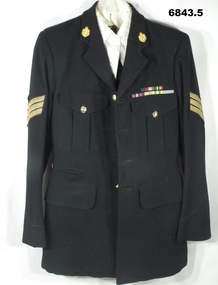
Uniform - MESS DRESS, ARMY, 1. 1950. 2. 1951. 3, 4, 5 unknown
... The pants have posssibly been used to make up a uniform. WW2 Postwar WW2 Uniform Passchendaele Barracks Trust Jacket - Inside has written - “3/2729 J.D. ...The Jacket belonged to Dennis James Powell, enlisted on 7.5.1941 No VX55199. Was a POW, discharged on 21.12.1945 in 2/29th Bn. Served Korea in the 3rd Bn No 32729 from 27.5.1951 - 14.8.1951, 24.9.51 - 22.4.1952. The service ribbons on the jacket are; 1939 - 45 Star Pacific Star British War Medal Australian Service Medal Korea Medal Un Medal Korea. The pants have posssibly been used to make up a uniform. 1. This is a black woollen jacket. It has 4 front pockets. It has Sgt's stripes on arm (Gold). It has RA Inf buttons. On the collars are another pattern RA Inf button - Kings Crown. Shiled design surrounded with oak leaves. Crossed rifles in centre of shield. It has six ribbons - see below. 2. Trousers - black wool. red stripe on legs. Fly is held shut with buttons, black. Two side pockets - One rear pocket. 3. Shirt - off white - civilian. 4. Belt - black wool, brass buckle. 5. Tie - black, purple liner.Jacket - Inside has written - “3/2729 J.D. Powell” Trousers- “ Jorgenson R/5”ww2, postwar ww2, uniform, passchendaele barracks trust -
 Eltham District Historical Society Inc
Audio - Audio Recording, The Prize, Eltham Films 1959, 11 Oct. 2023
... use the local area as the setting for his first film. Following this film Burstall went on to make many more. He became a key figure in Australian postwar cinema and was instrumental in helping to rebuild the Australian film industry, at a time when it had been effectively dead for years. ...use the local area as the setting for his first film. Following this film Burstall went on to make many more. He became a key figure in Australian postwar cinema and was instrumental in helping to rebuild the Australian film industry, at a time when it had been effectively dead for years. ...EDHS Newsletter No. 272 October 2023 Our next meeting will be a special evening, if not a little unusual. On pages 3 and 4 in this newsletter edition there are articles about Eltham Films, with particular reference to the film ‘The Prize’, made by Tim Burstall in 1958/59. As Burstall had strong connections with Eltham it would have been an easy decision for him and his associates to use the local area as the setting for his first film. Following this film Burstall went on to make many more. He became a key figure in Australian postwar cinema and was instrumental in helping to rebuild the Australian film industry, at a time when it had been effectively dead for years. At this EDHS meeting we will view this film, or should we say review this film, stopping at times to attempt to identify the main actors and where certain scenes were filmed around Eltham. Some locations may be more obvious than others. The actors are mainly children playing the characters in the film. So this will be an exercise in identifying people and places, whilst enjoying the rare opportunity to view a valued example of early Eltham film history.1:12:11 duration Digital MP3 file; 24.7MBaudio recording, eltham district historical society, meeting, society meeting, eltham, eltham films, guest speaker, the prize (film), tim burstall -
Glen Eira Historical Society
Document - KOOYONG ROAD, 75, CAULFIELD NORTH
... The pamphlet includes a brief history of the unit’s association with the City of Caulfield, a list of individuals holding posts within the Unit, text of the scroll conferring the Freedom of Entry on the Unit, a program of the ceremony, a brief history of the Royal Australian Army Ordnance Corps including the Unit’s use of 75 Kooyong Road as their premises, a brief history of the City of Caulfield from 1937-postwar years, and an explanation of the tradition of conferring Freedom of Entry to a city. ...The pamphlet includes a brief history of the unit’s association with the City of Caulfield, a list of individuals holding posts within the Unit, text of the scroll conferring the Freedom of Entry on the Unit, a program of the ceremony, a brief history of the Royal Australian Army Ordnance Corps including the Unit’s use of 75 Kooyong Road as their premises, a brief history of the City of Caulfield from 1937-postwar years, and an explanation of the tradition of conferring Freedom of Entry to a city. ...Two copies of a pamphlet for the ceremony of the Third Ordnance Services Unit ‘Exercising the Right of the Freedom of Entry to the City of Caulfield’ held on 23/10/1983. The pamphlet includes a brief history of the unit’s association with the City of Caulfield, a list of individuals holding posts within the Unit, text of the scroll conferring the Freedom of Entry on the Unit, a program of the ceremony, a brief history of the Royal Australian Army Ordnance Corps including the Unit’s use of 75 Kooyong Road as their premises, a brief history of the City of Caulfield from 1937-postwar years, and an explanation of the tradition of conferring Freedom of Entry to a city. The pamphlet includes also: 1/A black and white photograph (47x35mm) of the Mayor of Caulfield, W.R. Walters, undated and unattributed. 2/A black and white photograph (81x69mm) of Major A.G. Storen, Commanding Officer of the Third Ordnance Services Unit, undated and unattributed. 3/A color photograph (88x84mm) of the Sovereign’s Banner, undated and unattributed. 4/A black and white copy (137x87mm) of the scroll conferring Freedom of Entry into the City of Caulfield, which was seated August 4 1978. 5/A color illustration (30x32mm) of the City of Caulfield Coat of Arms. 6/A color illustration (40x32mm) of the Third Ordnance Services Unit, Royal Australian Army Ordnance Corps Coat of Arms. 7/A black and white illustration (21x24mm) of the city of Caulfield Coat of Arms. 8/A black and white illustration (19x14mm) of the City of Caulfield badge. 9/A black and white illustration (22x31mm) of the City of Caulfield banner.walters w.r., storen a.g. major, finning d.j. captain, hately p.g. major, davidson j. (captain), swendson r. (second lieutenant), caulfield, city of caulfield, australian army, the third ordnance services unit royal australian army ordnance corps, caulfield park, caulfield council, north caulfield, campton e.j. (brigadier), walters w.r. mrs., calder g.k., calder g.k. mrs., mahon j. (chief superintendent), city hall, balaclava road, hawthorn road, glen eira road, hartley avenue, kooyong road, caulfield racecourse, caulfield town hall, alma road, red cheques cab company, army headquarters printing press, searchlight company, amenities store, armoured replacement unit, first base printing company r.a.a.o.c., garden vale, caulfield railway station, paddy’s swamp, great dandenong road, glen ferrie road, dandenong road, east caulfield reserve, caulfield military hospital, ‘glen eira’, town hall, ‘war office’, caulfield district road board, shire of caulfield, caulfield recruiting committee for volunteers, city repatriation committee, red cross emergency service, women’s national service, mayor’s patriotic fund, promotions committee for war savings certificates, war savings group scheme, ‘the gazette’, air raid precautions committee, orrong road, armed forces, world war 1939-1945, local government, parades and processions, military reserves, world war 1914-1918, councillors, events and activities, historic events, official events, caulfield john, wyne agar, murphy (mayor), hale p., ison (captain), fisher andrew, morris t.w. (mayor) -
 City of Moorabbin Historical Society (Operating the Box Cottage Museum)
Tools, Bicycle spanner kit c1937, c1937
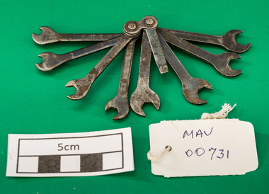
... Lottie Moore migrated to Australia 1949 and used it to repair her bicycles in Melbourne. bicycles tools spanners london melbourne migrants postwar immigration british made transport 'Nubot 100 British made' on spanner '8'. ...This tool kit of 8 spanners came with the purchase of a bicycle in London, England c1937. Lottie Moore migrated to Australia 1949 and used it to repair her bicycles in Melbourne.A set of 8 steel spanners for a bicycle c1937'Nubot 100 British made' on spanner '8'. Each spanner numbered 1 -8bicycles, tools spanners, london, melbourne, migrants, postwar immigration, british made, transport -
 Sunshine and District Historical Society Incorporated
Document - Brimbank Rising, Tony Smith, 2018
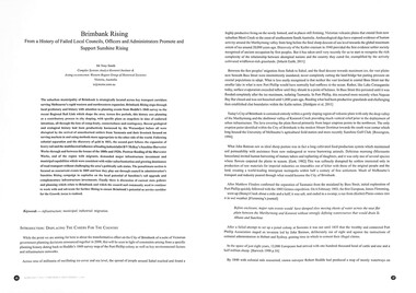
... using methods more appropriate to the other side of the world. Following colonial separation and the discovery of gold in 1851, the second part follows the expansion of heavy rail and the multifaceted influence of leading industrialist H V McKay’s Sunshine Harvester Works through and between the booms of the 1880s and 1920s. Postwar...using methods more appropriate to the other side of the world. Following colonial separation and the discovery of gold in 1851, the second part follows the expansion of heavy rail and the multifaceted influence of leading industrialist H V McKay’s Sunshine Harvester Works through and between the booms of the 1880s and 1920s. Postwar ...The suburban municipality of Brimbank is strategically located across key transport corridors serving Melbourne’s rapid western and northwestern expansion. Brimbank Rising steps through local prehistory and history with attention to planning events from Hoddle’s 1840 survey to the recent Regional Rail Link which shape the area. Across five periods, this history sees planning as a contributory process to city shaping, with specific plans as snapshots in time of endorsed intentions, all through the lens of complexity, connectedness and contingency. Recent geological and ecological history had been productively harnessed by the Wurundjeri before all were disrupted by the arrival of unauthorised settlers from Tasmania and their livestock focused on serving markets in and using methods more appropriate to the other side of the world. Following colonial separation and the discovery of gold in 1851, the second part follows the expansion of heavy rail and the multifaceted influence of leading industrialist H V McKay’s Sunshine Harvester Works through and between the booms of the 1880s and 1920s. Postwar flooding of the Harvester Works, and of the region with migrants, demanded major infrastructure investment and municipal capabilities which were consistent with wider suburbanisation and growing dominance of road transport without challenging the area’s politically safe status. The penultimate section is focused on concurrent events in 2009 and how they play out through council in administration’s Sunshine Rising campaign to capitalise on the local potential of Sunshine’s rail upgrade and complementary infrastructure investments. Finally, there is discussion of current state policies and planning which relate to Brimbank and which the council and community need to continue to work with and advocate for further Rising to ensure Brimbank’s potential as service corridor for the Growth Areas is realised.Brimbank Rising From a History of Failed Local Councils, Officers and Administrators Promote and Support Sunshine Risingaboriginal, first nation, h.v. mckay, sunshine harvester factory -
 Kew Historical Society Inc
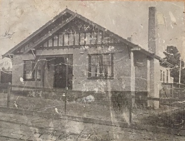
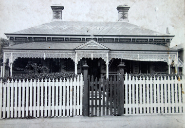
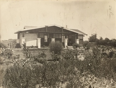
Photograph - Brick and Stucco Bungalow, J E Barnes, c.1920
... postwar period. These early plans were assembled by a local firm, Jas R Mather & McMillan, which had an office in Cotham Road. Many of the plans, and sometimes photos, were annotated by the agents. Subdivision plans are historically important documents used ...The Kew Historical Society's map collection includes a substantial number of real estate subdivision plans, mainly of Kew but also of surrounding suburbs in Melbourne. Most of the subdivision plans date from the 1920s and 1930s when the districts old homes and local farmland were being split up to accommodate residential growth in the postwar period. These early plans were assembled by a local firm, Jas R Mather & McMillan, which had an office in Cotham Road. Many of the plans, and sometimes photos, were annotated by the agents.Subdivision plans are historically important documents used as evidence for the growth of suburbs in Australia. They frequently provide information about when the land was sold as well as evidence relating to surveyors and real estate and financial agents. The numerous subdivision plans in the Kew Historical Society's collection represent working documents, ranging from the initial sketches made in planning a subdivision to printed plans on which auctioneers or agents listed the prices for which individual lots were sold. In a number of cases, the reverse of a subdivision plan in the collection includes a photograph of a house that was also for sale by the agent. These photographs provide significant heritage information relating house design and decoration, fencing and household gardens.The photograph may also be aesthetically significant depending o the importance of the photographic atelier.Real estate photograph for a local agent by the Kew photographer, Josiah Earl Barnes. The photo is of a weatherboard or brick rendered bungalow with a twisted wire fence. Given Barnes' status a a Kew photographer, the house is probably locate din Kew or East Kew. Unfortunately the handwritten information on the mount bordering the photo is damaged and cannot be read. The bungalow has a gabled, tiled roof with terra cotta finials at the front of both gables. The house has a central doorway, framed by a pseudo portico supported by four wooden columns. On each side of the doorway, at the front, there are paired sash windows, which, like the half-timbered gable, are picked out in a darker colour.Handwritten, mostly illegible description by selling agent on mount surround: " .... in Diningroom, Drawing Rooms, ... Photographers details printed on mount: "J. E. Barnes / Photo / Phone 1966 Haw KEW"houses - kew, bungalows - kew, real estate photographs, j.e. barnes -- photographer -
 Kew Historical Society Inc
Photograph - Victorian Double-fronted Brock Villa, Cotham Road, c. 1919
... postwar period. These early plans were assembled by a local firm, Jas R Mather & McMillan, which had an office in Cotham Road. Many of the plans, and sometimes photos, were annotated by the agents. Subdivision plans are historically important documents used ...The Kew Historical Society's map collection includes a substantial number of real estate subdivision plans, mainly of Kew but also of surrounding suburbs in Melbourne. Most of the subdivision plans date from the 1920s and 1930s when the districts old homes and local farmland were being split up to accommodate residential growth in the postwar period. These early plans were assembled by a local firm, Jas R Mather & McMillan, which had an office in Cotham Road. Many of the plans, and sometimes photos, were annotated by the agents.Subdivision plans are historically important documents used as evidence for the growth of suburbs in Australia. They frequently provide information about when the land was sold as well as evidence relating to surveyors and real estate and financial agents. The numerous subdivision plans in the Kew Historical Society's collection represent working documents, ranging from the initial sketches made in planning a subdivision to printed plans on which auctioneers or agents listed the prices for which individual lots were sold. In a number of cases, the reverse of a subdivision plan in the collection includes a photograph of a house that was also for sale by the agent. These photographs provide significant heritage information relating house design and decoration, fencing and household gardens.The photograph may also be aesthetically significant depending o the importance of the photographic atelier.Real estate photographs of a classic double-fronted late Victorian brick villa. It central location in Cotham Road, Kew enabled the selling agent to note its proximity to the tram. With seven rooms, all ‘modern conveniences’, and land of 66×167, the house was to be sold for £1100. The villa has a number of interesting features including a pattern within the slate roof as well as the use of polychrome brickwork under the eaves and on the façade. The intricacy of the cast iron lace is emphasised by the line of projecting wooden blocks above it. The picket gate is painted a different colour to the pickets of the fence. The house has a name (illegible) that is attached to the inset cast iron lace of the central projecting gable in the veranda. Stamped on mount: "Kew. Central. Close tram. / Comfortable Brick Villa. / Containing 7 rooms / Modern conveniences: / Land 66 x 167. Sold 1100 pounds:"houses - kew, victorian villas, real estate photographs, cotham road - kew -
 Kew Historical Society Inc
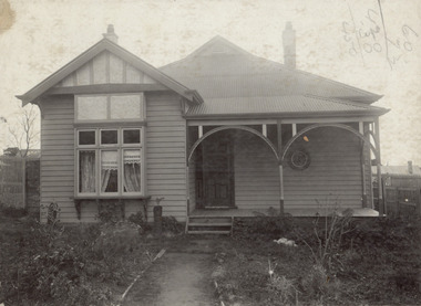
Photograph - Double-fronted Edwardian Villa, c.1918
... postwar period. These early plans were assembled by a local firm, Jas R Mather & McMillan, which had an office in Cotham Road. Many of the plans, and sometimes photos, were annotated by the agents. Subdivision plans are historically important documents used ...The Kew Historical Society's map collection includes a substantial number of real estate subdivision plans, mainly of Kew but also of surrounding suburbs in Melbourne. Most of the subdivision plans date from the 1920s and 1930s when the districts old homes and local farmland were being split up to accommodate residential growth in the postwar period. These early plans were assembled by a local firm, Jas R Mather & McMillan, which had an office in Cotham Road. Many of the plans, and sometimes photos, were annotated by the agents.Subdivision plans are historically important documents used as evidence for the growth of suburbs in Australia. They frequently provide information about when the land was sold as well as evidence relating to surveyors and real estate and financial agents. The numerous subdivision plans in the Kew Historical Society's collection represent working documents, ranging from the initial sketches made in planning a subdivision to printed plans on which auctioneers or agents listed the prices for which individual lots were sold. In a number of cases, the reverse of a subdivision plan in the collection includes a photograph of a house that was also for sale by the agent. These photographs provide significant heritage information relating house design and decoration, fencing and household gardens.The photograph may also be aesthetically significant depending on the importance of the photographic atelier.On the reverse of a subdivision plan of the Palmyra Estate (Kew) is a photograph of a double-fronted Edwardian villa. The weatherboard and stucco house with high brick chimneys provides a clear indication of the style of curtains and gardens in houses of the period. Holland blinds with lace inserts are used in the left front window. They are combined with long lace curtains. The garden, with its curved pathway is bordered with garden beds that include marguerite daisies and roses. Reflecting a new interest in the Australian landscape, tree ferns and ground ferns are planted closer to the house.houses - kew, architecture - edwardian, real estate photographs -
 Kew Historical Society Inc
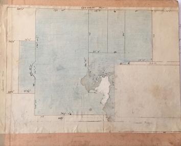
Plan - Subdivision : Cotham and Glenferrie Roads, J R Mathers & McMillan
... postwar period. These early plans were assembled by a local firm, Jas R Mather & McMillan, which had an office in Cotham Road. Many of the plans, and sometimes photos, were annotated by the agents. Subdivision plans are historically important documents used ...The Kew Historical Society's map collection includes a substantial number of real estate subdivision plans, mainly of Kew but also of surrounding suburbs in Melbourne. Most of the subdivision plans date from the 1920s and 1930s when the districts old homes and local farmland were being split up to accommodate residential growth in the postwar period. These early plans were assembled by a local firm, Jas R Mather & McMillan, which had an office in Cotham Road. Many of the plans, and sometimes photos, were annotated by the agents.Subdivision plans are historically important documents used as evidence for the growth of suburbs in Australia. They frequently provide information about when the land was sold as well as evidence relating to surveyors and real estate and financial agents. The numerous subdivision plans in the Kew Historical Society's collection represent working documents, ranging from the initial sketches made in planning a subdivision to printed plans on which auctioneers or agents listed the prices for which individual lots were sold. In a number of cases, the reverse of a subdivision plan in the collection includes a photograph of a house that was also for sale by the agent. These photographs provide significant heritage information relating house design and decoration, fencing and household gardens.The photograph may also be aesthetically significant depending on the importance of the photographic atelier.An undated and untitled hand-drawn and coloured subdivision plan detailing the boundaries of a number of irregular allotments bordering Cotham Road, Glenferrie Road and Stirling Avenue (now Stirling Street). The plan predates the actual subdivision that led to the creation of the eight commercial properties occupying 118-132 Cotham Road. The plan may represent an old subdivision that was further subdivided at a later date, or it may be a subdivision that never eventuated. On MMBW Detail Plan 1575 (1903), the area represented by the proposed subdivision was residential rather than commercial. The irregularity of lots is also apparent in the MMBW Plan. The largest of the unnumbered blocks on the hand-drawn subdivision plan may relate to the boundaries of the nineteenth century mansion identified as ‘Kelso’ on the MMBW Plan.subdivision plans - kew, cotham road - kew,, glenferrie road - kew , stirling avenue street - kew -
 Kew Historical Society Inc
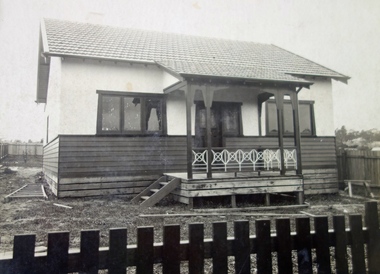
Photograph - Cottage, probably East Kew, A. Aberline, 1920s
... postwar period. These early plans were assembled by a local firm, Jas R Mather & McMillan, which had an office in Cotham Road. Many of the plans, and sometimes photos, were annotated by the agents. Subdivision plans are historically important documents used ...The Kew Historical Society's map collection includes a substantial number of real estate subdivision plans, mainly of Kew but also of surrounding suburbs in Melbourne. Most of the subdivision plans date from the 1920s and 1930s when the districts old homes and local farmland were being split up to accommodate residential growth in the postwar period. These early plans were assembled by a local firm, Jas R Mather & McMillan, which had an office in Cotham Road. Many of the plans, and sometimes photos, were annotated by the agents.Subdivision plans are historically important documents used as evidence for the growth of suburbs in Australia. They frequently provide information about when the land was sold as well as evidence relating to surveyors and real estate and financial agents. The numerous subdivision plans in the Kew Historical Society's collection represent working documents, ranging from the initial sketches made in planning a subdivision to printed plans on which auctioneers or agents listed the prices for which individual lots were sold. In a number of cases, the reverse of a subdivision plan in the collection includes a photograph of a house that was also for sale by the agent. These photographs provide significant heritage information relating house design and decoration, fencing and household gardens.The photograph may also be aesthetically significant depending on the importance of the photographic atelier.An elevated, modest weatherboard house, photographed towards the end of the construction phase. The lower section of the weatherboards are exposed and stained. The upper section is rendered with rough-cast. The tiled roof has a single gable that extends over the centrally placed front porch. On the porch, the door and single sidelight are filled with coloured leadlight whereas the casement windows in the front rooms contain plain glass. The leadlight and the wrought iron of the verandah are the only decorative elements of the utilitarian design. The location of the house, which was advertised for sale, has not to date been identified. The real estate photograph is mounted on the reverse of a subdivision plan for the Harvest Home Estate, Kew East.Photographer's stamp, lower right on mount: "A. Aberline, Glenferrie"houses - kew, bungalows - kew, real estate photographs -
 Kew Historical Society Inc
Photograph - Bungalow, probably East Kew, 1920s
... postwar period. These early plans were assembled by a local firm, Jas R Mather & McMillan, which had an office in Cotham Road. Many of the plans, and sometimes photos, were annotated by the agents. Subdivision plans are historically important documents used ...The Kew Historical Society's map collection includes a substantial number of real estate subdivision plans, mainly of Kew but also of surrounding suburbs in Melbourne. Most of the subdivision plans date from the 1920s and 1930s when the districts old homes and local farmland were being split up to accommodate residential growth in the postwar period. These early plans were assembled by a local firm, Jas R Mather & McMillan, which had an office in Cotham Road. Many of the plans, and sometimes photos, were annotated by the agents.Subdivision plans are historically important documents used as evidence for the growth of suburbs in Australia. They frequently provide information about when the land was sold as well as evidence relating to surveyors and real estate and financial agents. The numerous subdivision plans in the Kew Historical Society's collection represent working documents, ranging from the initial sketches made in planning a subdivision to printed plans on which auctioneers or agents listed the prices for which individual lots were sold. In a number of cases, the reverse of a subdivision plan in the collection includes a photograph of a house that was also for sale by the agent. These photographs provide significant heritage information relating house design and decoration, fencing and household gardens.The photograph may also be aesthetically significant depending on the importance of the photographic atelier.An unusual bungalow that does not conform to a particular architectural style but which contains eclectic elements of the style of varying periods. The most striking element of the design is the cantilevered veranda that is supported by heavy chains that are attached to the central gable. This deep gable extends across most of the façade, forming an extensive veranda. Parts of this are infilled with screens. Seven wooden posts, whose lower halves are encased in rendered brick pillars, support this gabled veranda. The roof would appear to be covered with corrugated iron. The location of the house, which was advertised for sale, has to date not been identified. The real estate photo is on the reverse of a plan for the Myrtle Hill Subdivision, Kew.bungalows - kew, architecture - 1920s, real estate photographs -
 Kew Historical Society Inc
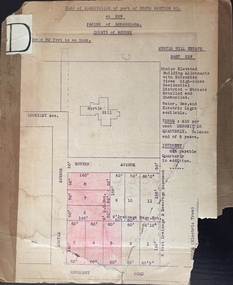
Plan - Subdivision Plan, J R Mathers & McMillan, Myrtle Hill Estate, East Kew, circa 1949, c.1949
... postwar period. These early plans were assembled by a local firm, Jas R Mather & McMillan, which had an office in Cotham Road. Many of the plans, and sometimes photos, were annotated by the agents. Subdivision plans are historically important documents used ...The Kew Historical Society's map collection includes a substantial number of real estate subdivision plans, mainly of Kew but also of surrounding suburbs in Melbourne. Most of the subdivision plans date from the 1920s and 1930s when the districts old homes and local farmland were being split up to accommodate residential growth in the postwar period. These early plans were assembled by a local firm, Jas R Mather & McMillan, which had an office in Cotham Road. Many of the plans, and sometimes photos, were annotated by the agents.Subdivision plans are historically important documents used as evidence for the growth of suburbs in Australia. They frequently provide information about when the land was sold as well as evidence relating to surveyors and real estate and financial agents. The numerous subdivision plans in the Kew Historical Society's collection represent working documents, ranging from the initial sketches made in planning a subdivision to printed plans on which auctioneers or agents listed the prices for which individual lots were sold. In a number of cases, the reverse of a subdivision plan in the collection includes a photograph of a house that was also for sale by the agent. These photographs provide significant heritage information relating house design and decoration, fencing and household gardens.The photograph may also be aesthetically significant depending on the importance of the photographic atelier.Myrtle Hill, at 14 Vista Avenue, Kew, is of local historical and architectural significance as a good example of a large and imposing single-storey Italianate house of the early 1870s surviving in Kew. Originally sited on a large allotment overlooking Normanby Road, the setting of the house has been dramatically altered through extensive subdivision and development. The subdivision plan of the ‘Myrtle Hill Estate’ indicates that in one such subdivision, 11 allotments were created fronting Bowyer Avenue, Myrtle Avenue, and Normanby Road. The outline and building profile of Myrtle Hill is shown on the west side of Bowyer Avenue.The full (typed) title of this subdivision plan is :"Plan of SUBDIVISION of part of CROWN PORTION 83. / at KEW / PARISH OF BOROONDARA. / COUNTY OF BOURKE". / "MYRTLE HILL ESTATE / EAST KEW" In addition to the Title and subtitle, the plan also lists the advantages of the subdivision. -
 Kew Historical Society Inc
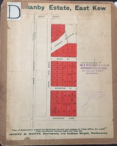
Plan - Subdivision Plan, J R Mathers & McMillan, Normanby Estate, c.1913
... postwar period. These early plans were assembled by a local firm, Jas R Mather & McMillan, which had an office in Cotham Road. Many of the plans, and sometimes photos, were annotated by the agents. Subdivision plans are historically important documents used ...The Kew Historical Society's map collection includes a substantial number of real estate subdivision plans, mainly of Kew but also of surrounding suburbs in Melbourne. Most of the subdivision plans date from the 1920s and 1930s when the districts old homes and local farmland were being split up to accommodate residential growth in the postwar period. These early plans were assembled by a local firm, Jas R Mather & McMillan, which had an office in Cotham Road. Many of the plans, and sometimes photos, were annotated by the agents.Subdivision plans are historically important documents used as evidence for the growth of suburbs in Australia. They frequently provide information about when the land was sold as well as evidence relating to surveyors and real estate and financial agents. The numerous subdivision plans in the Kew Historical Society's collection represent working documents, ranging from the initial sketches made in planning a subdivision to printed plans on which auctioneers or agents listed the prices for which individual lots were sold. In a number of cases, the reverse of a subdivision plan in the collection includes a photograph of a house that was also for sale by the agent. These photographs provide significant heritage information relating house design and decoration, fencing and household gardens.The photograph may also be aesthetically significant depending on the importance of the photographic atelier.The Normanby Estate, which was adjacent to Normanby Road, Kew East, included thirty-one lots for sale. Streets on the subdivision plan include Adeney Avenue, Park Hill Road, Normanby Road, Weir Street and Wharton Street. Cotham Road and its tramway are shown nearby. The plan is interesting as it shows Wharton Street, named after the architect and town planner George Wharton, who was the first chairman of the Municipality of Kew. The street was to later be renamed Cecil Street. Also shown are proposed ‘Municipal Gardens’ where Parkhill Drive is now located."D" in top left corner. Stamped auctioneers contact details: "Jas. R. Mathers & Son & McMillan / Auctioneer & Land Salesmen, / 271 Collins Street / Melbourne" and Jas. R. Mathers / Estate & Financial Agent / Cotham Road / Kew".weir street - kew, wharton street - kew, normanby road - kew, cotham road - kew, municipal gardens - kew, park hill parkhill road - kew, braemar - kew, subdivision plans - kew -
 Kew Historical Society Inc
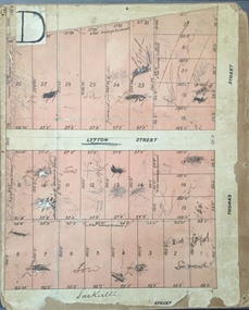
Plan, J R Mathers & McMillan, Sackville, Thomas & Lytton Streets, Kew, Twentieth Century
... postwar period. These early plans were assembled by a local firm, Jas R Mather & McMillan, which had an office in Cotham Road. Many of the plans, and sometimes photos, were annotated by the agents. Subdivision plans are historically important documents used ...The Kew Historical Society's map collection includes a substantial number of real estate subdivision plans, mainly of Kew but also of surrounding suburbs in Melbourne. Most of the subdivision plans date from the 1920s and 1930s when the districts old homes and local farmland were being split up to accommodate residential growth in the postwar period. These early plans were assembled by a local firm, Jas R Mather & McMillan, which had an office in Cotham Road. Many of the plans, and sometimes photos, were annotated by the agents.Subdivision plans are historically important documents used as evidence for the growth of suburbs in Australia. They frequently provide information about when the land was sold as well as evidence relating to surveyors and real estate and financial agents. The numerous subdivision plans in the Kew Historical Society's collection represent working documents, ranging from the initial sketches made in planning a subdivision to printed plans on which auctioneers or agents listed the prices for which individual lots were sold. In a number of cases, the reverse of a subdivision plan in the collection includes a photograph of a house that was also for sale by the agent. These photographs provide significant heritage information relating house design and decoration, fencing and household gardens.The photograph may also be aesthetically significant depending on the importance of the photographic atelier.Lithographed subdivision plan for an un-named estate with 28 allotments facing Lytton, Sackville and Thomas Streets in Kew. The land would have originally formed part of the Dumaresq Estate. subdivision plans - kew, lytton street, sackville street, thomas street - kew -
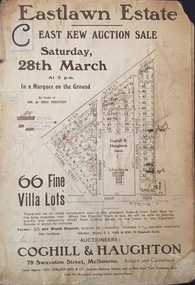 Kew Historical Society Inc
Plan - Subdivision Plan, Jas R Mathers Son & McMillan, Eastlawn Estate : East Kew Auction Sale, 1914
... postwar period. These early plans were assembled by a local firm, Jas R Mather & McMillan, which had an office in Cotham Road. Many of the plans, and sometimes photos, were annotated by the agents. Subdivision plans are historically important documents used ...The Kew Historical Society's map collection includes a substantial number of real estate subdivision plans, mainly of Kew but also of surrounding suburbs in Melbourne. Most of the subdivision plans date from the 1920s and 1930s when the districts old homes and local farmland were being split up to accommodate residential growth in the postwar period. These early plans were assembled by a local firm, Jas R Mather & McMillan, which had an office in Cotham Road. Many of the plans, and sometimes photos, were annotated by the agents.Subdivision plans are historically important documents used as evidence for the growth of suburbs in Australia. They frequently provide information about when the land was sold as well as evidence relating to surveyors and real estate and financial agents. The numerous subdivision plans in the Kew Historical Society's collection represent working documents, ranging from the initial sketches made in planning a subdivision to printed plans on which auctioneers or agents listed the prices for which individual lots were sold. In a number of cases, the reverse of a subdivision plan in the collection includes a photograph of a house that was also for sale by the agent. These photographs provide significant heritage information relating house design and decoration, fencing and household gardens.The photograph may also be aesthetically significant depending on the importance of the photographic atelier.The ‘Eastlawn Estate’ was surveyed and ready for auction in March 1914, three months before the outbreak of World War I. Sixty-six allotments, created on the ‘order of Mr & Miss Preston’ surrounded the mansion of Woodlands in Harp Road. Woodlands formed part of the Estate, being advertised as lot 1. The allotments faced High, Station and Wright Streets, Harp and Normanby Roads, and Woodlands Avenue. Pru Sanderson in the Kew Conservation Study (Vol.2, 1988) wrote that the Eastlawn Estate ‘covered the western half of the failed Harp of Erin Estate’. Contemporary advertisements promoted the Eastlawn Estate as: ‘There will be no more convenient district nor pleasant Suburb than East Kew for the busy business man. When the Electric Tram is laid, he will be able to journey quickly and pleasantly direct from Collins Street to his home in the Eastlawn Estate in about 20 minutes’. The actual plans of subdivision were included in advertisements in The Argus and in the local newspapers."C" top left. Various annotations.subdivision plans - kew, station street, normanby road, high street, woodlands avenue, harp road, woodlands - kew -
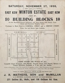 Kew Historical Society Inc
Plan - Subdivision Plan, Winton Estate, East Kew : Sale of 10 Building Blocks, 1920
... postwar period. These early plans were assembled by a local firm, Jas R Mather & McMillan, which had an office in Cotham Road. Many of the plans, and sometimes photos, were annotated by the agents. Subdivision plans are historically important documents used ...The Kew Historical Society's map collection includes a substantial number of real estate subdivision plans, mainly of Kew but also of surrounding suburbs in Melbourne. Most of the subdivision plans date from the 1920s and 1930s when the districts old homes and local farmland were being split up to accommodate residential growth in the postwar period. These early plans were assembled by a local firm, Jas R Mather & McMillan, which had an office in Cotham Road. Many of the plans, and sometimes photos, were annotated by the agents.Subdivision plans are historically important documents used as evidence for the growth of suburbs in Australia. They frequently provide information about when the land was sold as well as evidence relating to surveyors and real estate and financial agents. The numerous subdivision plans in the Kew Historical Society's collection represent working documents, ranging from the initial sketches made in planning a subdivision to printed plans on which auctioneers or agents listed the prices for which individual lots were sold. In a number of cases, the reverse of a subdivision plan in the collection includes a photograph of a house that was also for sale by the agent. These photographs provide significant heritage information relating house design and decoration, fencing and household gardens.The photograph may also be aesthetically significant depending on the importance of the photographic atelier.Subdivision plan for the so-called Winton Estate in East Kew. The Estate comprised 10 lots facing Simpson Street and Campbell Street. The estate was auctioned by Jas. R. Mathers, Son and McMillan. campbell street, simpson street, hunter street, normanby road - kew, subdivision plans - east kew, subdivision plans - kew -
![7 Roomed Brick [villa]; Modern Conveniences](/media/collectors/550653872162f11fb04854aa/items/59ec3da221ea690fdc4ba793/item-media/59ec3ee521ea690fdc4d0c37/item-fit-380x285.jpg?cb=6) Kew Historical Society Inc
Kew Historical Society IncPhotograph - 7 Roomed Brick [villa]; Modern Conveniences, 1920s
... postwar period. These early plans were assembled by a local firm, Jas R Mather & McMillan, which had an office in Cotham Road. Many of the plans, and sometimes photos, were annotated by the agents. Subdivision plans are historically important documents used ...The Kew Historical Society's map collection includes a substantial number of real estate subdivision plans, mainly of Kew but also of surrounding suburbs in Melbourne. Most of the subdivision plans date from the 1920s and 1930s when the districts old homes and local farmland were being split up to accommodate residential growth in the postwar period. These early plans were assembled by a local firm, Jas R Mather & McMillan, which had an office in Cotham Road. Many of the plans, and sometimes photos, were annotated by the agents.Subdivision plans are historically important documents used as evidence for the growth of suburbs in Australia. They frequently provide information about when the land was sold as well as evidence relating to surveyors and real estate and financial agents. The numerous subdivision plans in the Kew Historical Society's collection represent working documents, ranging from the initial sketches made in planning a subdivision to printed plans on which auctioneers or agents listed the prices for which individual lots were sold. In a number of cases, the reverse of a subdivision plan in the collection includes a photograph of a house that was also for sale by the agent. These photographs provide significant heritage information relating house design and decoration, fencing and household gardens.The photograph may also be aesthetically significant depending on the importance of the photographic atelier.A professionally produced photograph for a local real estate agent, probably Jas. R. Mathers, Son & McMillan. The photograph is of a Federation-era bungalow, in Kew. The photo is on the reverse of a subdivision plan for the Normanby Heights Estate, Kew.The mount on which the photograph is placed includes: "Kew. 1 minute to tram. Good Position. / 7 roomed brick. Modern conveniences. / Land 60 x 135. 1100 pounds"real estate photographs, houses - kew, federation architecture -
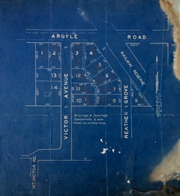 Kew Historical Society Inc
Plan - Subdivision Plan, Argyle Road, Heather Grove, Victor Avenue, Kew, c.1937
... postwar period. These early plans were assembled by a local firm, Jas R Mather & McMillan, which had an office in Cotham Road. Many of the plans, and sometimes photos, were annotated by the agents. Subdivision plans are historically important documents used ...The Kew Historical Society's map collection includes a substantial number of real estate subdivision plans, mainly of Kew but also of surrounding suburbs in Melbourne. Most of the subdivision plans date from the 1920s and 1930s when the districts old homes and local farmland were being split up to accommodate residential growth in the postwar period. These early plans were assembled by a local firm, Jas R Mather & McMillan, which had an office in Cotham Road. Many of the plans, and sometimes photos, were annotated by the agents.Subdivision plans are historically important documents used as evidence for the growth of suburbs in Australia. They frequently provide information about when the land was sold as well as evidence relating to surveyors and real estate and financial agents. The numerous subdivision plans in the Kew Historical Society's collection represent working documents, ranging from the initial sketches made in planning a subdivision to printed plans on which auctioneers or agents listed the prices for which individual lots were sold. In a number of cases, the reverse of a subdivision plan in the collection includes a photograph of a house that was also for sale by the agent. These photographs provide significant heritage information relating house design and decoration, fencing and household gardens.The photograph may also be aesthetically significant depending on the importance of the photographic atelier.Undated blue subdivision plan in Kew of 14 lots facing Argyle Road, Heather Grove and Victor Road. The Plan identifies Tuxen & Miller as the surveyors. [Formerly catalogued as MAP.0059]subdivision plans - kew, argyle road - kew, heather grove - kew, victor avenue - kew -
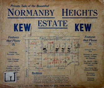 Kew Historical Society Inc
Plan - Subdivision Plan, Normanby Heights Estate, Kew, 1919
... The experience of Australia at war undoubtedly contributed to the use of terms such as ‘Backbone of a Nation’ and the appeal to egalitarian principles in the choice of the term ‘young citizen’. The recognition that women had savings and might be the prospective purchaser also reflects a new sense of the rights and entitlements of women in the postwar period....The experience of Australia at war undoubtedly contributed to the use of terms such as ‘Backbone of a Nation’ and the appeal to egalitarian principles in the choice of the term ‘young citizen’. The recognition that women had savings and might be the prospective purchaser also reflects a new sense of the rights and entitlements of women in the postwar period. ...Prue Sanderson, in her groundbreaking ‘City of Kew Urban Conservation Study : Volume 2 - Development History’ (1988), summarised the periods of urban development and subdivisions of land in Kew. The periods that she identified included 1845-1880, 1880-1893, 1893-1921, 1921-1933, 1933-1943, and Post-War Development. These periods were selected as they represented periods of rapid growth or decline in urban development. An obvious starting point for Sanderson’s groupings involved population growth and the associated economic cycles. These cycles also highlighted urban expansion onto land that was predominantly rural, although in other cases it represented the decline and breakup of large estates. A number of the plans in the Kew Historical Society’s collection can also be found in other collections, such as those of the State Library of Victoria and the Boroondara Library Service. A number are however unique to the collection.The Kew Historical Society collection includes almost 100 subdivision plans pertaining to suburbs of the City of Melbourne. Most of these are of Kew, Kew East or Studley Park, although a smaller number are plans of Camberwell, Deepdene, Balwyn and Hawthorn. It is believed that the majority of the plans were gifted to the Society by persons connected with the real estate firm - J. R. Mathers and McMillan, 136 Cotham Road, Kew. The Plans in the collection are rarely in pristine form, being working plans on which the agent would write notes and record lots sold and the prices of these. The subdivision plans are historically significant examples of the growth of urban Melbourne from the beginning of the 20th Century up until the 1980s. A number of the plans are double-sided and often include a photograph on the reverse. A number of the latter are by noted photographers such as J.E. Barnes.The Normanby Heights Estate not unusually used hyperbole to attract purchasers to the auction of 17 lots facing Argyle Street (sic), Pleasant Avenue and Normanby Road. Predictably factors appealed to included the proximity to schools etc, the availability of public utilities, friable soil, picturesque views and ‘advancing settlement’. If that were not enough, the sales pitch exhorted prospective purchasers to consider their backbone. ‘Thrift is unquestionably the Backbone of any Nation. No better form of Thrift can be encouraged in the young citizen than by investing his or her savings in a piece of land in a growing, healthy and beautiful locality. NORMANBY HEIGHTS ESTATE admirably fits the need.’ The experience of Australia at war undoubtedly contributed to the use of terms such as ‘Backbone of a Nation’ and the appeal to egalitarian principles in the choice of the term ‘young citizen’. The recognition that women had savings and might be the prospective purchaser also reflects a new sense of the rights and entitlements of women in the postwar period.subdivision plans - kew, normanby heights estate, pleasant avenue, normanby road, argyle street -
 Wodonga & District Historical Society Inc
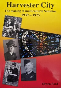
Book - Harvester City - The Making of Multicultural Sunshine 1939 - 1975, Olwen Ford, Published 2012
... postwar migration This publication by the Sunshine & District Historical Society builds on an earlier publication "Harvester Town: The Making of Sunshine 1890-1925". It focuses on the post-war migration years when thousands of young immigrants settled in the new City of Sunshine, bought land, built homes, had families and worked in the area's important industries. It uses ...This publication by the Sunshine & District Historical Society builds on an earlier publication "Harvester Town: The Making of Sunshine 1890-1925". It focuses on the post-war migration years when thousands of young immigrants settled in the new City of Sunshine, bought land, built homes, had families and worked in the area's important industries. It uses a range of primary resources including photos, photo stories, interviews and other documents to explain the challenges, achievements and issues faced in the development of "Multicultural Sunshine"A soft cover publication of 590 pages. The cover features several photos of people and places in Sunshine, The background of these cover photos is coloured in yellow and orange. The book includes photos and photo stories as well as extracts from newspapers, government archives and census records to document key developments and stories of hardships and achievements during a critical period of industrialisation and postwar migration to Australia. It includes bibliographical references and an index.non-fictionThis publication by the Sunshine & District Historical Society builds on an earlier publication "Harvester Town: The Making of Sunshine 1890-1925". It focuses on the post-war migration years when thousands of young immigrants settled in the new City of Sunshine, bought land, built homes, had families and worked in the area's important industries. It uses a range of primary resources including photos, photo stories, interviews and other documents to explain the challenges, achievements and issues faced in the development of "Multicultural Sunshine"multiculturalism australia, , sunshine victoria, postwar migration -
 Kew Historical Society Inc
Book, Civvy Symphony, December, 1946 : the world since V.P. day / cartooned by Armstrong of the Argus, 1946, 1946
... used by members for research into aspects of local history and/or to support the Society's collections of pictures, maps, fashion and artefacts. Reference books have entered the collection through donation, presentation, collection and purchase. Important social document illustrating Australian views of the world in the immediate postwar ...Kew Historical Society, founded in 1958, has an extensive reference library, of which this book is a part. Volumes in the library are used by members for research into aspects of local history and/or to support the Society's collections of pictures, maps, fashion and artefacts. Reference books have entered the collection through donation, presentation, collection and purchase.Important social document illustrating Australian views of the world in the immediate postwar periodMont Albert [Vic.] : Edgar J.K. Thompson for the Argus and Australasian Ltd., 1946 48 p. : chiefly ill. (some col.) ; 31 cm. "australian wit and humour -- pictorial, australia -- social life and customs -- 1945-1965 -- caricatures and cartoons. -
 Kew Historical Society Inc
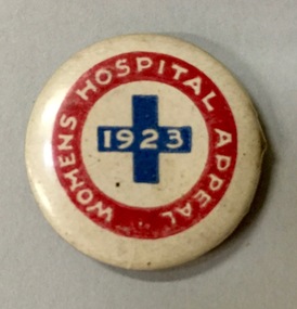
Badge - Fundraising Button, Women’s Hospital Appeal 1923, 1923
... A postwar fundraising button featuring a simple design using white text in a red boarder with and central blue cross. ...used at festivals and sporting events. Because of the manufacturing process, many surviving buttons and badges have been affected by inadequate storage, suffering from oxidisation and physical damage. These survivors are now historically and socially significant artefacts, revealing much about the attitudes and values of the period in which they were produced. Their widespread distribution means that they are frequently significant at a local, state, national and international level. royal womens hospital fundraising buttons badges "Women’s Hospital Appeal 1923" A postwar ...Frances Rigg was a local business identity in Kew, at one stage managing the local branch of the English, Scottish and Australian (ES&A) Bank at 175 High Street from c. 1920 until the 1940s. After Francis Rigg’s death, the collection of buttons and medallions was inherited by his son, Ken Rigg (1922-2014). The collection was subsequently donated to the Kew Historical Society in 2015 by Francis' grandson, Adrian Rigg, at the time of the Gallipoli & Beyond Commemoration in 2015. The collection covers a period of almost 40 years. The majority of the buttons are patriotic buttons, issued and sold during and immediately after the First World World War (1914-1918) to raise funds for national and overseas causes. The collection also includes a number of locally significant sporting event buttons and sporting club medallions, issued in the 1920s and 1930s.Patriotic and other pressed tin buttons and badges were produced in large numbers in the first decades of the twentieth century. By nature, insubstantial and ephemeral, they have not always survived. The collections of badges, buttons and medallions in the Kew Historical Society collection is homogenous and yet diverse, ranging from buttons sold to raise funds for the war efforts in 1914-18 and 1939-45, to those used at festivals and sporting events. Because of the manufacturing process, many surviving buttons and badges have been affected by inadequate storage, suffering from oxidisation and physical damage. These survivors are now historically and socially significant artefacts, revealing much about the attitudes and values of the period in which they were produced. Their widespread distribution means that they are frequently significant at a local, state, national and international level.A postwar fundraising button featuring a simple design using white text in a red boarder with and central blue cross. In February when the buttons were sold, The Argus reported that: ‘Each suburban municipality has formed a committee under its mayoress, to assist in the button distribution, and local committees in the country are also working for the success of the appeal. Kiosks are prohibited in the city streets, but many suburban councils have granted permission for their erection. In addition to buttons, many kinds of saleable articles will be obtainable at the kiosks.’"Women’s Hospital Appeal 1923"royal womens hospital, fundraising buttons, badges -
 Kew Historical Society Inc
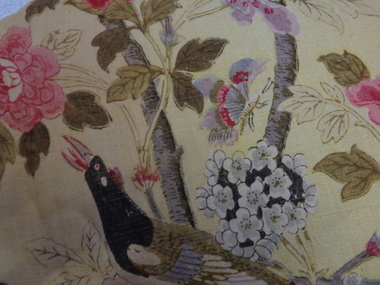
Decorative object - Paradise Bird Design Linen Curtains, GP&J Baker, 1920s
... The first use of the design was in 1918, following the Great War, and the design is said to reflect the hope for peace which was a feature of the postwar years. ...William Turner, a Scottish born free-lance designer, who was contracted to GP&J Baker, painted the image on which the design was based in 1918. Turner had trained as a furniture designer before leaving for London in the 1890s, where he rose to prominence as an Arts & Crafts designer. The bird that gives this design its name is adapted from Robert Havell’s ‘A Collection of Birds of Paradise’, published in 1835, and was a favourite of Victorian chintz designers.“Paradise Bird” has been in continuous production since its creation. The hand-block print, of which these curtains are an early example, was supplemented by a version engraved on copper rollers in 1962, and was updated onto screens in 1982. The curtains have significance to the collection because of their intrinsic value and for the link to one of the historic mansions in the City of Boroondara. The curtains by G.P & J Baker of London use one of the exemplary designs in this manufacturer’s output. The first use of the design was in 1918, following the Great War, and the design is said to reflect the hope for peace which was a feature of the postwar years. The curtains are an early example of the Paradise Bird design, and were block printed. A pair of curtains originally situated in one of the front reception rooms of 'Tourmont' in Balwyn Road, Balwyn (now Fintona Girls’ School). The fabric in the curtains was manufactured by the English firm of GP&J Baker. The textile design is variably named as ‘Paradise Bird’ or more recently, ‘Hydrangea Bird’. Turner’s bird perches in a blossoming branch directly above a woodpecker, which is an attribute of Mars, god of war. Thus the design reads as a symbolic statement where War is reversed and Paradise returns (a hopeful message at the end of WWI). “Paradise Bird” has been in continuous production since its creation. . curtains, fabric design, historic buildings -
 Bendigo Historical Society Inc.
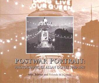
Book - "Postwar Portrait. Photographs by Allan Doney. 1900-1987", 2002
... In early 2025, using archival materials purchased by the NTAV, a dedicated team of Bendigo Historical Society volunteers carefully and methodically re-housed all 14,000 negatives into archival-grade folders, greatly enhancing their long-term preservation and accessibility. Doney Photographs Bendigo Mid-century "Postwar ...Allan Doney was a tailer by profession, born in July, 1900 in East Ballarat. His family later moved to Dimboola in the Wimmera where his interest in photography began with his first camera, aged 15. He married and moved to Bendigo in 1949 where he set up business as a tailor. The 1950's was a time of great change in Bendigo, which was not well recorded photographically. Doney took and printed high quality photographs of events, scenes and buildings. Allan Doney (1900–1987) was a passionate amateur photographer with a keen eye for everyday life in and around Bendigo. From the 1950s through to the 1970s, he photographed streetscapes, events, industries, and ordinary moments that together form an extraordinary visual record of the region. Allan’s extensive body of work offers remarkable insight into the Bendigo region’s social and cultural history. Doney sold his collection of prints and negatives to the National Trust for $2,000 in 1980 - comprising 14,000 negatives and 3,000 prints. For more than three decades, the negatives were loaned to the Bendigo Library (Goldfields Library Corporation). In 2024, the long-standing loan with the Bendigo Library concluded, and a new loan agreement for the negatives was established with the Bendigo Historical Society. In early 2025, using archival materials purchased by the NTAV, a dedicated team of Bendigo Historical Society volunteers carefully and methodically re-housed all 14,000 negatives into archival-grade folders, greatly enhancing their long-term preservation and accessibility. "Postwar Portrait. Photographs by Allan Doney. 1900-1987" written by Mike Butcher and Yolande M j Colllins. Contains images by the Allan Doney, photographer. Published in Australia by Holland House for the National Trust of Australia (Victoria) in 2002. Soft cover. Cover is primarily gold of different tones with a black and white image of the Alexandria Fountain, Bendigo, inset on front cover; and black and white image inset of Allan Doney on back cover. Book includes black and white images with brief description of each image. Forward by Stephen Hare, CEO, National Trust of Australia (Victoria). 148 pp. Contents page at the front of book lists each image and page number. ISBN 978-0-9871627-1-7.doney, photographs, bendigo, mid-century