Showing 44 items matching "poverty street"
-
 Tarnagulla History Archive
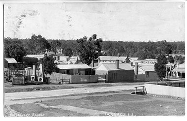
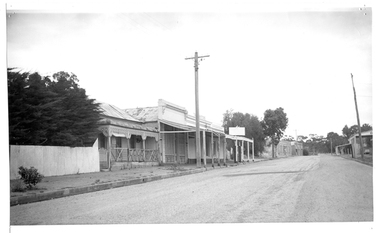
Photograph of Tarnagulla from Poverty Street, behind Bank, Tarnagulla from Poverty Street, behind Bank, Between 1886 and 1899
... Photograph of Tarnagulla from Poverty Street, behind Bank...Tarnagulla from Poverty Street, behind Bank......poverty street...View of part of Commercial Road and Poverty Streets, Tarnagulla, from a position on Poverty Street behind the Bank site. ...Corner of Poverty Street and Commercial Road, Tarnagulla, Victoria, Australia...View of part of Commercial Road and Poverty Streets, Tarnagulla, from a position on Poverty Street behind the Bank site. ...Murray Comrie Collection. Information collated by Murray Comrie: Photo after 1886 and before 1899. Shows bakers shop at corner of Commercial Rd and Poverty St, bakery stables and horse. Clouston's, Renshaw's Victoria House, Golden Age Hotel, Renshaw's Commerce House and Post Office. This is an original photographic postcard. Monochrome photographic postcard. View of part of Commercial Road and Poverty Streets, Tarnagulla, from a position on Poverty Street behind the Bank site. Premises on Commercial Road which are visible include the Golden Age Hotel and Renshaw's Drapers.Text near bottom edge: 'Johnsn & Co. Ararat' and 'Tarnagulla'.tarnagulla, commerce, shops, businesses, streetscapes, horses, stables, poverty street, commercial road, main street, golden age hotel, renshaw's, bakery, clouston's -
 Tarnagulla History Archive
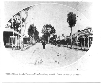
Photograph of Commercial Road, Tarnagulla looking south from Poverty Street, Commercial Road, Tarnagulla Looking South from Poverty Street, January 1907, at the time of the Poseidon Gold Rush, circa 1890 - 1900
... Photograph of Commercial Road, Tarnagulla looking south from Poverty Street....Commercial Road, Tarnagulla Looking South from Poverty Street, January 1907, at the time of the Poseidon Gold Rush....Typed caption on original is 'Commercial Road, Tarnagulla, looking south from Poverty Street'....Photograph of Commercial Road, Tarnagulla looking south from Poverty Street. ...Murray Comrie Collection. This is a reasonable copy of an older original. Copy probably made by Murray Comrie in the 1970s. Monochrome photograph. View of Commercial Road Tarnagulla looking south. A man at centre, walking toward camera. Right of this figure are two carts standing at the road's edge. Far right is Renshaw's Drapery and left of that the Golden Age Hotel. A man is walking along the footpath in front of Renshaw's. Typed caption on original is 'Commercial Road, Tarnagulla, looking south from Poverty Street'.tarnagulla, commerce, stores, shopping, shops, draper, hotels, golden age hotel, buildings, commercial road, main street -
 Tarnagulla History Archive
Postcard - Photographic postcard: Commercial Road, Tarnagulla looking south from Poverty Street, c. 1910
... Photographic postcard: Commercial Road, Tarnagulla looking south from Poverty Street...Photographic postcard, front image depicting Commercial Road, Tarnagulla looking south from Poverty Street. ...Tarnagulla History Archive Tarnagulla Public Hall 69-71 Commercial Rd Tarnagulla goldfields Williams Family Collection. tarnagulla Handwritten on reverse: '1/2 main street, Commercial Road, Tarnagulla' and 'L.Williams Tarnagulla' Photographic postcard, front image depicting Commercial Road, Tarnagulla looking south from Poverty Street. Postcard Photographic postcard: Commercial Road, Tarnagulla looking south from Poverty Street ...Williams Family Collection. Photographic postcard, front image depicting Commercial Road, Tarnagulla looking south from Poverty Street. Handwritten on reverse: '1/2 main street, Commercial Road, Tarnagulla' and 'L.Williams Tarnagulla'tarnagulla -
 Tarnagulla History Archive
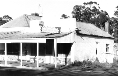
Photograph: Building on corner of Poverty Street and Commercial Road, Tarnagulla
... Photograph: Building on corner of Poverty Street and Commercial Road, Tarnagulla...Photograph: Building on corner of Poverty Street and Commercial Road, Tarnagulla Stokes & Son ...David Gordon Collection. -
 Tarnagulla History Archive
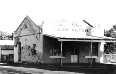
Photograph: Cash Butcher building on corner of Poverty Street and Commercial Road, Tarnagulla
... Photograph: Cash Butcher building on corner of Poverty Street and Commercial Road, Tarnagulla...Photograph: Cash Butcher building on corner of Poverty Street and Commercial Road, Tarnagulla Stokes & Son ...David Gordon Collection. -
 Tarnagulla History Archive
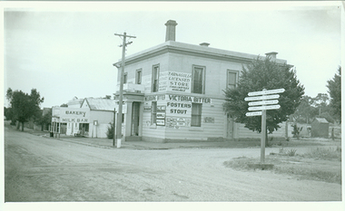
Photograph of former bank building being used as general store, Tarnagulla, Former bank building being used as general store, Tarnagulla, circa late 1960s
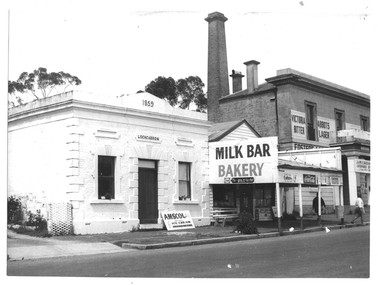
... Monochrome photograph depicting a section of Commercial Road, Tarnagulla at the intersection with Poverty Street, including two stores - one a bakery/milk-bar and the other a general store operating in the former Bank building. ...Probably taken by Murray Comrie in the late 1960s. tarnagulla banks banking commerce stores shopping shops food groceries buildings commercial road Monochrome photograph depicting a section of Commercial Road, Tarnagulla at the intersection with Poverty Street, including two stores - one a bakery/milk-bar and the other a general store operating in the former Bank building. ...Murray Comrie Collection. This image depicts stores in the main street of Tarnagulla, including the two-storey bank building being used as a licensed general store. The bank building was used first by the Colonial Bank of Australasia (from 1866 to 1888) and then by the Union Bank (from 1888 to 1942). The two-storey bank building was built in 1866 by the Colonial Bank of Australasia. Before this, the site had been occupied by Foo's shop. Whilst it was being built, the Colonial Bank operated from Company's Hotel (later known as Burstall Hall and the Council Chambers). The new double-storey building was used by the Colonial Bank from 1866 until 21st February, 1888. The premises were sold to the Union Bank for £2500. The Union Bank moved in and commenced operations on 6th June 1888, continuing until 1942. The building was later used as a general store until the 1990s. It is a now private residence. Probably taken by Murray Comrie in the late 1960s. Monochrome photograph depicting a section of Commercial Road, Tarnagulla at the intersection with Poverty Street, including two stores - one a bakery/milk-bar and the other a general store operating in the former Bank building. tarnagulla, banks, banking, commerce, stores, shopping, shops, food, groceries, buildings, commercial road -
 Tarnagulla History Archive
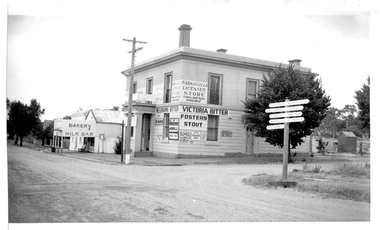
Photograph of former bank building being used as general store, Tarnagulla, Former bank building being used as general store, Tarnagulla, circa 1960s-70s
... Monochrome photograph depicting a section of Commercial Road, Tarnagulla at the intersection with Poverty Street, including two stores - one a bakery/milk-bar and the other a general store operating in the former Bank building. ...Copy probably made by Murray Comrie in the 1970s. tarnagulla banks banking commerce stores shopping shops food groceries buildings commercial road Monochrome photograph depicting a section of Commercial Road, Tarnagulla at the intersection with Poverty Street, including two stores - one a bakery/milk-bar and the other a general store operating in the former Bank building. ...Murray Comrie Collection. This image depicts stores in the main street of Tarnagulla, including the two-storey bank building being used as a licensed general store. The bank building was used first by the Colonial Bank of Australasia (from 1866 to 1888) and then by the Union Bank (from 1888 to 1942). The two-storey bank building was built in 1866 by the Colonial Bank of Australasia. Before this, the site had been occupied by Foo's shop. Whilst it was being built, the Colonial Bank operated from Company's Hotel (later known as Burstall Hall and the Council Chambers). The new double-storey building was used by the Colonial Bank from 1866 until 21st February, 1888. The premises were sold to the Union Bank for £2500. The Union Bank moved in and commenced operations on 6th June 1888, continuing until 1942. The building was later used as a general store until the 1990s. It is a now private residence. This is a reasonable copy of an older original. Copy probably made by Murray Comrie in the 1970s. Monochrome photograph depicting a section of Commercial Road, Tarnagulla at the intersection with Poverty Street, including two stores - one a bakery/milk-bar and the other a general store operating in the former Bank building. The general store was operated at this time by James Buchanan. tarnagulla, banks, banking, commerce, stores, shopping, shops, food, groceries, buildings, commercial road -
 Tarnagulla History Archive
Photograph looking down Commercial Road, Tarnagulla, Looking down Commercial Road, Tarnagulla, c.1960s
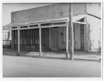
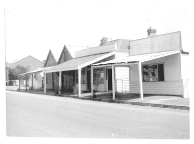
... Shopfront located on west side of Commercial Rd between King and Poverty Streets. Original print....Shopfront located on west side of Commercial Rd between King and Poverty Streets. Original print. tarnagulla buildings businesses commercial road Monochrome photograph of a shopfront in Commercial Road, Tarnagulla. ...Murray Comrie Collection. Shopfront located on west side of Commercial Rd between King and Poverty Streets. Original print.Monochrome photograph of a shopfront in Commercial Road, Tarnagulla. tarnagulla, buildings, businesses, commercial road -
 Tarnagulla History Archive
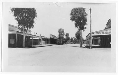
Photograph looking up Commercial Road, Tarnagulla, Looking up Commercial Road, Tarnagulla, c.1960s
... View looking up Commercial Road, Tarnagulla, from the Poverty Street intersection. Street deserted - no people or vehicles visible. ...View looking up Commercial Road, Tarnagulla, from the Poverty Street intersection. Street deserted - no people or vehicles visible. ...Murray Comrie Collection. Original print.Monochrome photograph. View looking up Commercial Road, Tarnagulla, from the Poverty Street intersection. Street deserted - no people or vehicles visible. Building with text 'Williams & Clouston's' visible at far right. Willersdorf;s store opposite, and the Borough Council Chambers can vaguely be seen in the left distance. tarnagulla, businesses, commercial road -
Tarnagulla History Archive
Registration of Birth form, 1870
... Registration of Birth form for: Child's name: Harry Charles Smith Date of Birth: section missing but known from older transcription: 1871 Place of birth: Poverty Street, Tarnagulla Father: William Smith Mother: section missing but known from older transcription: Margaret Ann (nee Hodgson)...Registration of Birth form for: Child's name: Harry Charles Smith Date of Birth: section missing but known from older transcription: 1871 Place of birth: Poverty Street, Tarnagulla Father: William Smith Mother: section missing but known from older transcription: Margaret Ann (nee Hodgson) Registration of Birth form ...A large lot of papers, including this and many other birth and death registration forms, were apparently found in the ceiling cavity of the Sandy Creek/Tarnagulla Post and Telegraph Office in the later 20th Century, during building works. Donald Clark Collection. Registration of Birth form for: Child's name: Harry Charles Smith Date of Birth: section missing but known from older transcription: 1871 Place of birth: Poverty Street, Tarnagulla Father: William Smith Mother: section missing but known from older transcription: Margaret Ann (nee Hodgson) -
 Tarnagulla History Archive
Photograph of buildings on Commercial Road, Tarnagulla, Buildings on Commercial Road, Tarnagulla, Late 1960s
... Commercial Road Tarnagulla between Poverty and Wayman Streets. ...Commercial Road Tarnagulla between Poverty and Wayman Streets. Buildings on Commercial Road, Tarnagulla Photograph of buildings on Commercial Road, Tarnagulla ...Murray Comrie Collection. Burstall Hall is visible in the distant background.Monochrome photograph, streetscape. Commercial Road Tarnagulla between Poverty and Wayman Streets. tarnagulla, buildings, commercial road -
 Tarnagulla History Archive
Photograph of buildings on Commercial Road, Tarnagulla, Buildings on Commercial Road, Tarnagulla, Late 1960s
... Commercial Road Tarnagulla between Poverty and King Streets. ...Commercial Road Tarnagulla between Poverty and King Streets. Buildings on Commercial Road, Tarnagulla Photograph of buildings on Commercial Road, Tarnagulla ...Murray Comrie Collection. A good quality original print.Monochrome photograph, streetscape. Commercial Road Tarnagulla between Poverty and King Streets. tarnagulla, buildings, commercial road -
 Tarnagulla History Archive
Photograph of milk bar and general store, Tarnagulla, Milk bar and general store, Tarnagulla, circa 1960s-70s
... Monochrome photograph depicting a section of Commercial Road, Tarnagulla near the intersection with Poverty Street, including two stores - one a bakery/milk-bar and the other a general store operating in the former Colonial/Union Bank building. ...Copy probably made by Murray Comrie in the 1970s. tarnagulla banks banking commerce stores shopping shops food groceries buildings commercial road Monochrome photograph depicting a section of Commercial Road, Tarnagulla near the intersection with Poverty Street, including two stores - one a bakery/milk-bar and the other a general store operating in the former Colonial/Union Bank building. ...Murray Comrie Collection. This image depicts stores in the main street of Tarnagulla, including the two-storey bank building being used as a licensed general store. The building on the left was also a bank, originally constructed by the Union Bank in 1859, and Is probably the first brick and stone building at Tarnagulla. It was used by the bank until 1888 at which time the Union and Colonial banks amalgamated. After this, the building was used for a variety of purposes. The milk bar section was constructed in the 1920s in an area at the front of what had once been the Bank’s manager’s residence. The Two-story bank building On the right was constructed and used by the Colonial Bank of Australasia (from 1866 to 1888) and, following bank amalgamation, by the Union Bank (from 1888 until closure in 1942). The original site had been occupied by Joseph Foo's store, a large wooden building with attached theatre. While the bank was being built, the Colonial Bank operated from the former Company's Hotel (soon after to become the Borough of Tarnagulla Council Chambers, then the Mechanics’ Institute, and finally, prior to final demolition in 1980, Burstall Hall) The new double-storey building was used by the Colonial Bank from 1866 until 21st February, 1888. The premises were sold to the Union Bank for £2500. The Union Bank moved in and commenced operations on 6th June 1888, continuing until 1942. The building was later used as a general store until the 1990s. It is a now private residence. This is a reasonable copy of an older original. Copy probably made by Murray Comrie in the 1970s. Monochrome photograph depicting a section of Commercial Road, Tarnagulla near the intersection with Poverty Street, including two stores - one a bakery/milk-bar and the other a general store operating in the former Colonial/Union Bank building. Photograph taken from north of milk-bar. Two people walking away from photographer on footpath/curb between the two stores. The building on the left was the Union Bank premises, constructed in 1859 and Tarnagulla's oldest surviving brick building. The Union Bank absorbed the Colonial Bank in 1888, and the Union Bank moved operations next door into the much larger former Colonial Bank premises which had been constructed in 1865/66. After amalgamation, the old Union Bank premises was then used for a variety of purposes from visiting doctor's rooms to cafe, etc. The Union Bank continued to operate at Tarnagulla until closure in 1942, at which time business had fallen away and Tarnagulla Branch had already been downgraded to sub-branch status. tarnagulla, banks, banking, commerce, stores, shopping, shops, food, groceries, buildings, commercial road -
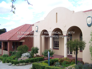
 Eltham District Historical Society Inc
Photograph - Digital Photograph, Alan King, St Margaret's Anglican Church, Pitt Street, Eltham, 30 January 2008
... Street and the Shillinglaw Cottage near Eltham’s Central Park. It is believed the first Anglican Bishop of Melbourne, Bishop Perry, dedicated the church. After the ceremony he joined in the festivities at the nearby pub and a bill was sent to the parish for teas taken there by the bishop with other participants. The first vicar was the Reverend Robert Mackie from 1864 to1866. St Margaret’s Church was originally called Christ Church until its consecration in 1871, when it was completely free of debt (£1700 pounds for the church and parsonage) despite the district’s poverty...Street and the Shillinglaw Cottage near Eltham’s Central Park. It is believed the first Anglican Bishop of Melbourne, Bishop Perry, dedicated the church. After the ceremony he joined in the festivities at the nearby pub and a bill was sent to the parish for teas taken there by the bishop with other participants. The first vicar was the Reverend Robert Mackie from 1864 to1866. St Margaret’s Church was originally called Christ Church until its consecration in 1871, when it was completely free of debt (£1700 pounds for the church and parsonage) despite the district’s poverty ...St Margaret’s Church of England was officially opened on December 12, 1861. It is the oldest intact church building in Eltham. At the time it was known as Christ Church until its consecration in 1871, when it was completely free of debt (£1,700 for the church and parsonage) despite the district’s poverty. This was largely due to the free labour and materials, including locally made bricks donated by local artisans and others. The church is historically significant because it is the oldest church in the former Shire of Eltham and has associations with the philanthropist and founder of Brighton, Henry Dendy (who donated the land on which the church is built), the architect Nathaniel Billing and the prominent local builder, George Stebbing. The church is architecturally and aesthetically significant because it is constructed in the Gothic Revival style with several stained-glass windows of various dates and is also a very early use of polychromatic brickwork in Victoria. Billing was one of the first Melbourne architects to employ polychromatic brickwork and an important early architect. The rear wall was intended to be temporary. A major feature of the design is the large buttresses with long, steeply graded upper faces. The overall design is well proportioned with the surface brick patterns relieving an otherwise austere design. The church is spiritually and socially significant because it has been an important place of worship for the people of Eltham for almost 150 years. The land on which the buildings stand was donated by Henry Dendy. Dendy arrived in Melbourne in 1841 after purchasing in England eight square miles at Brighton under the system of "special surveys". After this land passed out of his hands, Dendy moved about Victoria, visited England, then returned to settle in Eltham where he purchased a flour mill. Dendy chaired the meeting held in 1860 “for the purpose of devising such means as may be expedient for the establishment of a Church of England in the township of Eltham”. He became chairman and treasurer of the church committee. Unlike the establishment of many early churches in Victoria where a vicar was appointed to a parish and later a permanent church was constructed, the population at Eltham initiated action to build a church. The nearest church at that time was at Heidelberg and the Eltham settlement was part of the parish of St Johns Heidelberg. Isolation and the tedious, time consuming journey between Heidelberg and Eltham resulted in the Eltham community taking its own action. The original vicarage (Dendy House) at the rear of the church is also an important part of the cultural significance of this place because it is connected to the church and the development of the Eltham area. Together, the church and the vicarage are aesthetically significant because they form a significant streetscape feature. The mud-brick community hall designed by Robert Marshall was added in 1978. In 2014 the original temporary rear wall was removed as part of a modern extension designed by Architects Atelier Wagner and constructed by Conrad Construction and Management. Covered under Heritage Overlay, Nillumbik Planning Scheme. National Trust of Australia (Victoria) State significance Victorian Heritage Published: Nillumbik Now and Then / Marguerite Marshall 2008; photographs Alan King with Marguerite Marshall.; p67 St Margaret’s Anglican Church in Pitt Street, Eltham, which officially opened on December 12, 1861, is the oldest intact church building in Eltham.1 With the nearby courthouse and police station, it was one of the first permanent community buildings in the district. The church and vicarage are on the Register of the Heritage Council of Victoria and the National Trust of Australia – Victoria. The church is important as an early example of polychrome brickwork by the notable architect Nathaniel Billings. It is also notable for its historic associations with the early settlement of the Shire of Eltham and its connection with Henry Dendy, Brighton’s founder.2 Henry Dendy, who lived in Eltham much longer than at Brighton, chaired the original meeting which planned the church, and he donated the half-acre (0.2ha) site. Dendy had arrived in Melbourne in 1841 after buying eight square miles (20.7sq km) at Brighton while in England. After this land passed out of his hands, he eventually settled in Eltham where he bought a flour mill, west from the corner of Main Road and Pitt Street (then called Brewery Lane). The vicarage was named Dendy House after him. The Eltham settlers were unusual in initiating the establishment of a church. Usually in Victoria a vicar was appointed to a parish and then a permanent church was constructed. But then, the nearest church was at Heidelberg, which was a tedious and time-consuming journey. St Margaret’s builder was a local, George Stebbing, who also constructed the former Methodist, later Uniting, Church at John Street and the Shillinglaw Cottage near Eltham’s Central Park. It is believed the first Anglican Bishop of Melbourne, Bishop Perry, dedicated the church. After the ceremony he joined in the festivities at the nearby pub and a bill was sent to the parish for teas taken there by the bishop with other participants. The first vicar was the Reverend Robert Mackie from 1864 to1866. St Margaret’s Church was originally called Christ Church until its consecration in 1871, when it was completely free of debt (£1700 pounds for the church and parsonage) despite the district’s poverty. This was largely due to the free labour and materials, including local bricks, donated by local artisans and others. St Margaret’s Church is in the Gothic Revival tradition with a buttressed nave, paired lancet windows, porch and bell-cote. It was the first polychromatic brick church in Australia, using softly contrasting coloured brickwork.3 Billing was one of the first architects to introduce polychrome brickwork into Melbourne. His original drawings for St Margaret’s survive in a folio of his architectural work. However the church’s brickwork is more subdued than in his drawings. About half the windows – those in clear glass with gold borders – are original. The stained glass windows were made much later, but the one behind the altar is thought to be the oldest in the Diamond Valley. It was to be temporary until the congregation could afford to extend the church. In the early 1960s the original cedar pews were replaced by blonde timber pews and the originals were sold to restaurants and to private individuals. Eminent local sculptor Matcham Skipper created a crucifix for the church. A major addition was made in 1978, when the weatherboard hall was replaced by a mud-brick hall. Made of local material, it was designed by local architect and a former shire president Robert Marshall. The mud-brick hall reflects the style of building in Eltham of the late 1970s and for which Eltham is well-known. Perhaps because its earthy tones blend with the surrounding environment, the hall sits well with the church building. St Margaret’s membership has included economist and ABC chairman, Richard Downing; political commentator, diplomat and academic, William Macmahon Ball; Eltham civic leader, Charles Wingrove; artist, Peter Glass; and Eltham’s first postmaster, Frederick Falkiner.This collection of almost 130 photos about places and people within the Shire of Nillumbik, an urban and rural municipality in Melbourne's north, contributes to an understanding of the history of the Shire. Published in 2008 immediately prior to the Black Saturday bushfires of February 7, 2009, it documents sites that were impacted, and in some cases destroyed by the fires. It includes photographs taken especially for the publication, creating a unique time capsule representing the Shire in the early 21st century. It remains the most recent comprehenesive publication devoted to the Shire's history connecting local residents to the past. nillumbik now and then (marshall-king) collection, eltham, st margaret's anglican church, st margaret's church, st margarets church hall, christ church -
 Eltham District Historical Society Inc
Photograph - Digital Photograph, Marguerite Marshall, Sutherland Home for Children, Diamond Creek, 27 September 2007
... poverty, or because single parents could not cope. However later, most placements occurred due to family violence, abuse or neglect. The property was originally bought from the Crown in 1869 by Timothy Mahony. Later owner, Augusta Meglin, ran a 40-acre (16ha) farm there. In 1909 she bequeathed this, including the house, orchards, vegetable gardens, vineyards and the balance of her income to The Sutherland Homes for Neglected Children. Sutherland Homes’ founder, Selina Sutherland, was known as ‘New Zealand’s Florence Nightingale’. In 1888 she became Victoria’s first licensed ‘child rescuer’3 and was to rescue around 3000 waifs from Victoria’s streets...poverty, or because single parents could not cope. However later, most placements occurred due to family violence, abuse or neglect. The property was originally bought from the Crown in 1869 by Timothy Mahony. Later owner, Augusta Meglin, ran a 40-acre (16ha) farm there. In 1909 she bequeathed this, including the house, orchards, vegetable gardens, vineyards and the balance of her income to The Sutherland Homes for Neglected Children. Sutherland Homes’ founder, Selina Sutherland, was known as ‘New Zealand’s Florence Nightingale’. In 1888 she became Victoria’s first licensed ‘child rescuer’3 and was to rescue around 3000 waifs from Victoria’s streets ...The Sutherland Homes for Children on Yan Yean Road, Diamond Creek cared for thousands of children from when it was opened in 1912. The site closed for this purpose in 1991 and was sold and later developed for commercial and office purposes. Covered under Heritage Overlay, Nillumbik Planning Scheme. Published: Nillumbik Now and Then / Marguerite Marshall 2008; photographs Alan King with Marguerite Marshall.; p107 The Sutherland Homes for Children at 14 Yan Yean Road, Diamond Creek, cared for thousands of children since they opened in 1912, after beginning at La Trobe Street, Melbourne in 1908. In 1994 Sutherland Homes (then called Sutherland Child, Youth and Family Services) amalgamated with Berry Street Child and Family Welfare. Together as Berry Street Victoria, they formed Victoria’s largest independent provider of support and accommodation services for children, young people and families in crisis.1 However with the move from institutional to community care, the Diamond Creek site had not been used since 1991 and was sold to private purchasers in 1999. More than 2000 former residents, staff, neighbours and friends attended a farewell in February, 2000.2 The Sutherland Homes red-brick and stuccoed building in Diamond Creek (a rare design in the Eltham Shire), was opened in 1929 by Lord Somers, the Governor of Victoria. Destitute children lived in dormitories bathed in natural light through large windows. However in 1958 as the cottage–parent system replaced the dormitory system, the first of eight residential cottages accommodating ten to 12 children was built. The site also included Special School 3660 and a farm, and the children were able to form relationships with people outside Sutherland, by staying with holiday hosts. Children were originally placed at Sutherland because of extreme poverty, or because single parents could not cope. However later, most placements occurred due to family violence, abuse or neglect. The property was originally bought from the Crown in 1869 by Timothy Mahony. Later owner, Augusta Meglin, ran a 40-acre (16ha) farm there. In 1909 she bequeathed this, including the house, orchards, vegetable gardens, vineyards and the balance of her income to The Sutherland Homes for Neglected Children. Sutherland Homes’ founder, Selina Sutherland, was known as ‘New Zealand’s Florence Nightingale’. In 1888 she became Victoria’s first licensed ‘child rescuer’3 and was to rescue around 3000 waifs from Victoria’s streets and slums.4 Born in Scotland in 1839, Sutherland joined her sister, who had emigrated with her husband to New Zealand. Sutherland trained as a nurse and led the establishment of a public hospital at Masterton. In 1881, while holidaying in Melbourne, Sutherland was so touched by seeing young people living under Princes Bridge, that this determined her future work. Meanwhile Sutherland instigated the Melbourne District Nursing Society, (now Royal District Nursing Service). She also led the founding of The Victorian Neglected Children’s Aid Society (now Oz Child) and the Presbyterian Neglected Children’s Aid Society (now Kildonan). From 1894 Miss Sutherland was Melbourne’s best known woman and cut a distinctive figure, wearing an alpine hat with a prominent feather. In 1906 Prime Minister Alfred Deakin named her Melbourne’s most successful philanthropic worker. However she was to face some difficult times. That year she suffered severely from an injured shoulder and dizzy turns and was pressured to resign as Superintendent of The Victorian Neglected Children’s Aid Society. In 1908 the committee of management offered her 12 months leave with pay. Sutherland declined – but soon after, was dismissed. However she continued her work from Latrobe Street, Melbourne, with the help of Sister Ellen Sanderson and several committee members. Sutherland attempted to register her new organisation but the Victorian Neglected Children’s Aid Society objected to the government, alleging that Sutherland, because of increasing infirmity, was unable to satisfactorily carry out such duties. They accused her of cruelty and of intoxication. However the charges were not proven, so The Sutherland Homes for Neglected Children was registered.5 Sadly, in 1909 Sutherland died, the day she was to move the children to the ‘country property’ at Diamond Creek. At her death she owned less than £10. Today Berry Street recognises Sutherland’s enormous contribution to child welfare with a memorial and an annual Selina Sutherland Award, presented to an outstanding volunteer.This collection of almost 130 photos about places and people within the Shire of Nillumbik, an urban and rural municipality in Melbourne's north, contributes to an understanding of the history of the Shire. Published in 2008 immediately prior to the Black Saturday bushfires of February 7, 2009, it documents sites that were impacted, and in some cases destroyed by the fires. It includes photographs taken especially for the publication, creating a unique time capsule representing the Shire in the early 21st century. It remains the most recent comprehenesive publication devoted to the Shire's history connecting local residents to the past. nillumbik now and then (marshall-king) collection, diamond creek, sutherland home for children -
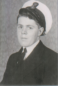 The Beechworth Burke Museum
Audio - Oral History, Jennifer Williams, Mr Ray Stone, 8th June 2000
... street...navy...The Great Depression...poverty...While the township of Beechworth is known for its history as a gold rush town, these accounts provide a unique insight into the day-to-day life of the town's residents during the 20th century, many of which will have now been lost if they had not been preserved. listen to what they say beechworth oral history burke museum stone ray stone tannery tanneries finch street navy The Great Depression poverty wheelbarrow race cars gift footrace marriage travel Mr Ray Stone / This is a digital copy of a recording that was originally captured on a cassette tape. ...Ray Stone was born in 1927, growing up in Beechworth as the oldest of eight children, but spent much of his life travelling, which he recalls in this oral history. Although he started working at the Beechworth Tannery with his father, he joined the Navy before he was of age in 1944 to support the war effort, and upon returning to Beechworth gave up on the Tannery after half a day to continue working jobs across Victoria instead. He talks extensively about watching Beechworth's famous Wheelbarrow race, where Tony Evans bet Tom Parkinson that the latter would not be able to push the former in a wheelbarrow from the Beechworth Post Office to Mt Buffalo in eight days. Calling himself a "helper all [his] life", he discusses the way many towns he worked in would come together to support struggling families, especially widows. In comparison, he suggests that the Beechworth of 2000 is much less community-orientated. He also discusses the economic changes he's witnessed around Beechworth, from the difficulties during the Depression while he was a child, to business improvements at the Tannery and Brewery, to the tourism boom. This oral history recording was part of a project conducted by Jennifer Williams in the year 2000 to capture the everyday life and struggles in Beechworth during the twentieth century. This project involved recording seventy oral histories on cassette tapes of local Beechworth residents which were then published in a book titled: Listen to what they say: voices of twentieth century Beechworth. These cassette tapes were digitised in July 2021 with funds made available by the Friends of the Burke.Ray Stone's account of his life is historically and socially significant to the region of Beechworth for the way it describes changes in the town over the twentieth century. It covers themes including community relationships, business development, and cultural life. It makes this commentary in comparison to nearby regions such as the Snowy Mountains. This oral history account is socially and historically significant as it is a part of a broader collection of interviews conducted by Jennifer Williams which were published in the book 'Listen to what they say: voices of twentieth-century Beechworth.' While the township of Beechworth is known for its history as a gold rush town, these accounts provide a unique insight into the day-to-day life of the town's residents during the 20th century, many of which will have now been lost if they had not been preserved.This is a digital copy of a recording that was originally captured on a cassette tape. The cassette tape is black with a horizontal white strip and is currently stored in a clear flat plastic rectangular container. It holds up 40 minutes of recordings on each side.Mr Ray Stone /listen to what they say, beechworth, oral history, burke museum, stone, ray stone, tannery, tanneries, finch street, navy, the great depression, poverty, wheelbarrow race, cars, gift footrace, marriage, travel -
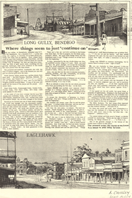 Bendigo Historical Society Inc.
Newspaper - LONG GULLY HISTORY GROUP COLLECTION: LONG GULLY - BENDIGO
... History House 11 Mackenzie Street Bendigo goldfields BHS Collection BENDIGO History long gully history group The Long Gully History Group - Long Gully - Bendigo Nell Gynne Hercules Deborah New Chum Tyson's Reef Dead Horse Gully Pennyweight Gully Golden Gully Poverty Gully Poor Man's Gully Job's Gully Methodist Chapel The Shamrock Bulls Head Old House at Home Five Lions Photocopy of a newspaper page two titled Long Gully, Bendigo Where things seem to just 'continue on'. ...BHS CollectionPhotocopy of a newspaper page two titled Long Gully, Bendigo Where things seem to just 'continue on'. At the top of the page is a sketched streetscape of Long Gully with buildings and a poppet legs along the street, tram tracks going around a corner and some people on the street. At the bottom of the page is a streetscape of Eaglehawk with buildings along the street, tram tracks and electrical poles in the centre of the road.. Written at the top of the page is Approx 1936 and at the bottom of the page is A Crossley Long Gully. The article mentions what it was like in the early years and late refers to biblical references.bendigo, history, long gully history group, the long gully history group - long gully - bendigo, nell gynne, hercules, deborah, new chum, tyson's reef, dead horse gully, pennyweight gully, golden gully, poverty gully, poor man's gully, job's gully, methodist chapel, the shamrock, bulls head, old house at home, five lions -
 Bendigo Historical Society Inc.
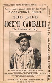
Book - LYDIA CHANCELLOR COLLECTION: THE LIFE OF JOSEPH GARIBALDI
... History House 11 Mackenzie Street Bendigo goldfields BOOKS Biography joseph garibaldi Lydia Chancellor collection Joseph Garibaldi person individual male famous people Italy Italilan history Ward & Lock's Penny Historical Series Ward & Lock's Penny Books for the People Biographical Series penny books advertisements A book titled 'The Life of Joseph Garibaldi the liberator of Italy. The brave warrior who freed his country from the yoke of despotism. The ardent, persevering and unconquerable p atriot, who preferred honourable poverty ...A book titled 'The Life of Joseph Garibaldi the liberator of Italy. The brave warrior who freed his country from the yoke of despotism. The ardent, persevering and unconquerable p atriot, who preferred honourable poverty to splendid servitude.' London : Ward, Lock & Co., Salisbury Square, E.C.This booklet is one of a series of 53 ' Ward & Lock's Penny Books for the People.' 'Biographical Series.' Price one penny. There are advertisements of note.books, biography, joseph garibaldi, lydia chancellor, collection, joseph garibaldi, person, individual, male, famous people, italy, italilan history, ward & lock's penny historical series, ward & lock's penny books for the people, biographical series, penny books, advertisements -
 Bendigo Historical Society Inc.
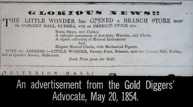
Slide - DIGGERS & MINING. STORES AT THE DIGGINGS, May 20, 1854
... Street Bendigo goldfields EDUCATION Tertiary goldfields hanimount Diggers & Mining. Stores at the diggings. GLORIOUS NEWS!! THE LITTLE WONDER has OPENED a BRANCH STORE near the CONCERT HALL, EUREKA, with an IMMENSE STOCK of - Boots, shoes and clothes. A splendid assortment of Jewellery, watches and Clocks. A superb collection of Musical Instruments and Elegant Musical Clocks with Mechanical Figures. NOTE the ADDRESS!:- LITTLE WONDER, Poverty ...Diggers & Mining. Stores at the diggings. GLORIOUS NEWS!! THE LITTLE WONDER has OPENED a BRANCH STORE near the CONCERT HALL, EUREKA, with an IMMENSE STOCK of - Boots, shoes and clothes. A splendid assortment of Jewellery, watches and Clocks. A superb collection of Musical Instruments and Elegant Musical Clocks with Mechanical Figures. NOTE the ADDRESS!:- LITTLE WONDER, Poverty Point, Balaarat, near the concert Hall Eureka and at Queen's Arcade, Melbourne. Bank price given for gold. Slide reads: An advertisement from the Gold Diggers' Advocate, May 20, 1854. Markings: 17 994.LIF. 5. Used as a teaching aid.hanimounteducation, tertiary, goldfields -
 Bendigo Historical Society Inc.
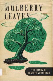
Book - ALEC H CHISHOLM COLLECTION: BOOK ''MULBERRY LEAVES'' BY CLIVE TURNBULL
... Street Bendigo goldfields BOOKS Collections biography ALEC H CHISHOLM COLLECTION CLIVE TURNBULL CHARLES WHITEHEAD BIOGRAPHY Clive Turnbull Book. ALEC H CHISHOLM COLLECTION. 42 page hardcover book telling the story of Charles Whitehead, a forgotten author, associate of Charles Dickens who came to Melbourne in the gold rush days and died in poverty. ...Book. ALEC H CHISHOLM COLLECTION. 42 page hardcover book telling the story of Charles Whitehead, a forgotten author, associate of Charles Dickens who came to Melbourne in the gold rush days and died in poverty. Published in 1945 by the Hawthorn Press, Melbourne. Designed and printed by John Gartner at the Hawthorn Press. Edition limited to 500 copies. Catalogue sticker ''2162 TUR'' on spine. Handwritten in ink on flyleaf '' To Alec Chisholm, this tribute laid at the foot of the Viceroy's throne, by his Obednt Servt Clive Turnbull 22 : vii : 45 ''Clive Turnbullbooks, collections, biography, alec h chisholm collection, clive turnbull, charles whitehead, biography -
 Bendigo Historical Society Inc.
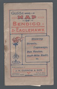
Map - GUIDE MAP OF BENDIGO & EAGLEHAWK, Late 1920's
... Street and Bridge Lane. Also shows Acclimitization Reserve located behind The Botanical Gardens at White Hills. Shows the location of Sailors Gully, Peg-Leg Gully, Jobs Gully, California Gully, Long Gully, Ironbark Gully, Golden Gully, Poverty Gully, Sheepshead Gully, Charcoal Gully, Eaglehawk Creek, Bendigo Creek and Back Creek. ...Street and Bridge Lane. Also shows Acclimitization Reserve located behind The Botanical Gardens at White Hills. Shows the location of Sailors Gully, Peg-Leg Gully, Jobs Gully, California Gully, Long Gully, Ironbark Gully, Golden Gully, Poverty Gully, Sheepshead Gully, Charcoal Gully, Eaglehawk Creek, Bendigo Creek and Back Creek. ...Map. Guide Map of Bendigo & Eaglehawk. Light brown coloured booklet containing folded map of Bendigo and Eaglehawk. Outer cover is printed in blue and red ink and states - With compliments of J H Curnow & Son, Auctioneers, Real Estate Agents, Farm & Dairy Produce Merchants, Bendigo. Printed by J B Young, Lithographer. Map shows tramways & bus routes. Map shows Agricultural Showgrounds located between Park Street, Water Street, Barnard Street and Bridge Lane. Also shows Acclimitization Reserve located behind The Botanical Gardens at White Hills. Shows the location of Sailors Gully, Peg-Leg Gully, Jobs Gully, California Gully, Long Gully, Ironbark Gully, Golden Gully, Poverty Gully, Sheepshead Gully, Charcoal Gully, Eaglehawk Creek, Bendigo Creek and Back Creek. Contains interesting facts about Bendigo - Area 7,900 acres. Population - 26,000. First Council elected - 1855. Proclaimed a Borough - 1863. Proclaimed a City - 1871. Gold Rush broke out - 1851. For first 10 years gold yield averaged 8,600 ozs. per week . Total gold yield to 1923 - 572 tons valued at 82,000,000 pounds. Deepest mines - Victoria Quartz 4,614 ft., New Chum Railway 4,318 ft. 13 mines over 3.000 ft. deep. 53 mines over 2,000 ft. deep. Sewering of City commenced 1922, all principal buildings now sewered. Map printed by Arnall & Jackson, General Printers, Stationers & Engravers, 476 Collins Street. Map displays advertisement for J H Curnow & Son, Bendigo's leading Auctioneer and Estate Agents, Mitchell & Queen Sts. Bendigo. Map Scale 20 chs. = 1 in.cottage, miners, guide map of bendigo and eaglehawk -
 Bendigo Historical Society Inc.
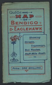
Map - GUIDE MAP OF BENDIGO & EAGLEHAWK, Late 1920's
... Street and Bridge Lane. Also shows Acclimitization Reserve located behind the Botanical Gardens at White Hills. Shows the location of Sailors Gully, Peg-Leg Gully, Jobs Gully, California Gully, Long Gully, Ironbark Gully, Golden Gully, Poverty Gully, Sheepshead Gully, Charcoal Gully, Eaglehawk Creek, Bendigo Creek and Back Creek.Contains interesting facts about Bendigo:- Area - 7,900 acres, Population - 26,000, First Council elected - 1855, Proclaimed a City - 1871. ...Street and Bridge Lane. Also shows Acclimitization Reserve located behind the Botanical Gardens at White Hills. Shows the location of Sailors Gully, Peg-Leg Gully, Jobs Gully, California Gully, Long Gully, Ironbark Gully, Golden Gully, Poverty Gully, Sheepshead Gully, Charcoal Gully, Eaglehawk Creek, Bendigo Creek and Back Creek.Contains interesting facts about Bendigo:- Area - 7,900 acres, Population - 26,000, First Council elected - 1855, Proclaimed a City - 1871. ...Map. Guide map of Bendigo & Eaglehawk. Folded map of Bendigo & Eaglehawk with blue outer cover booklet. Map is compiled by E E Parker, Eaglehawk. Map shows tramways, bus routes and cost one shilling. Map shows Agricultural Showgrounds located between Park Street, Water Street, Barnard Street and Bridge Lane. Also shows Acclimitization Reserve located behind the Botanical Gardens at White Hills. Shows the location of Sailors Gully, Peg-Leg Gully, Jobs Gully, California Gully, Long Gully, Ironbark Gully, Golden Gully, Poverty Gully, Sheepshead Gully, Charcoal Gully, Eaglehawk Creek, Bendigo Creek and Back Creek.Contains interesting facts about Bendigo:- Area - 7,900 acres, Population - 26,000, First Council elected - 1855, Proclaimed a City - 1871. Gold Rush broke out - 1851. For first 10 years gold yield averaged 8,600 ozs. Per week. Total gold yield to 1923 - 572 tons valued at 82,000,000 pounds. Deepest mines - Victoria Quartz 4,614 ft., New Chum Railway 4,318 ft., 13 mines over 3,000ft. deep, 53 mines over 2,000 ft. deep. Sewering of City commenced 1922. All principal buildings now sewered. Map printed by Arnall & Jackson, General Printers, Stationers & Engravers, 476 Collins Street. Outer map blue cover printed in red and blue ink by J B Young, Lithographer. Map displays advertisement for Bendigo Timber Co. Outer blue cover displays advertisement for Campbell Connelly & Co. Pty. Ltd, Ironmongers, Timware Manufacturers, Plumbers, Sewerage Contractors, High and Forest Sts, Bendigo 9outside back cover) and for Hartleys ( J L Shoosmith) Bendigo, displaying Indian Motor Cycles (inside back cover).map, bendigo, township, guide map of bendigo & eaglehawk -
 Federation University Historical Collection
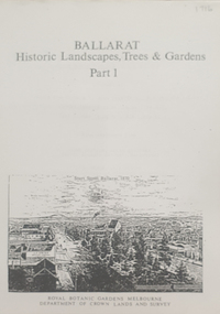
Book, Peter Lumley et al, Ballarat: Historic Landscapes, Trees & Gardens, 1983, 1983
... 275 page landscape study of Ballarat including Trees in the Victorian Landscape; Plant sources early Ballarat nurseries, Botanical Gardens, Lake Wendouree, Fairy Gardens, Victoria Park, Ballaarat Old Cemetery, Eastern Oval, City Oval, Ballarat East Town Hall Gardens, Eureka Stockade, Observatory, Yarrowee, Black Hill, Sovereign Hill, Cheek Channels, Canadian Creek, Poverty Point Reserve, Goldmining Relics, Woah Hawp, Buninyong, street plantings, Russell, Victoria, Bridge Mall, Sturt Street Gardens, Avenue of Honour, Webster, Elms, ...Barker Library (top floor) Mount Helen goldfields Lisa Green and Lisa Morcom of Ballarat College of Advanced Educatiion contributed to this report. ballarat trees nursery r.u. nicholls francis moss ballarat botanical gardens Victoria Park Lake Wendouree Ballaarat Old Cemetery Eastern Oval Ballarat East Town Hall Gardens Ballarat School of Mines Botanical gardens Eureka Stckade Recreation Reserve Ballarat Observatory Yarrowee Creek Black Hill Reserve Sovereign Hill Ballarat Avenue of Honour Victoria Street plantings Bridge Mall Plantings george longley 275 page landscape study of Ballarat including Trees in the Victorian Landscape; Plant sources early Ballarat nurseries, Botanical Gardens, Lake Wendouree, Fairy Gardens, Victoria Park, Ballaarat Old Cemetery, Eastern Oval, City Oval, Ballarat East Town Hall Gardens, Eureka Stockade, Observatory, Yarrowee, Black Hill, Sovereign Hill, Cheek Channels, Canadian Creek, Poverty Point Reserve, Goldmining Relics, Woah Hawp, Buninyong, street plantings, Russell, Victoria, Bridge Mall, Sturt Street Gardens, Avenue of Honour, Webster, Elms, Ballarat: Historic Landscapes, Trees & Gardens, 1983 Book Book Peter Lumley John Dyke Roger Spencer Eve Almond ...Lisa Green and Lisa Morcom of Ballarat College of Advanced Educatiion contributed to this report.275 page landscape study of Ballarat including Trees in the Victorian Landscape; Plant sources early Ballarat nurseries, Botanical Gardens, Lake Wendouree, Fairy Gardens, Victoria Park, Ballaarat Old Cemetery, Eastern Oval, City Oval, Ballarat East Town Hall Gardens, Eureka Stockade, Observatory, Yarrowee, Black Hill, Sovereign Hill, Cheek Channels, Canadian Creek, Poverty Point Reserve, Goldmining Relics, Woah Hawp, Buninyong, street plantings, Russell, Victoria, Bridge Mall, Sturt Street Gardens, Avenue of Honour, Webster, Elms, ballarat, trees, nursery, r.u. nicholls, francis moss, ballarat botanical gardens, victoria park, lake wendouree, ballaarat old cemetery, eastern oval, ballarat east town hall gardens, ballarat school of mines botanical gardens, eureka stckade recreation reserve, ballarat observatory, yarrowee creek, black hill reserve, sovereign hill, ballarat avenue of honour, victoria street plantings, bridge mall plantings, george longley -
Federation University Historical Collection
Book, Historic Sites Survey: North Central Study Area, 1979, 1979
... poverty point reserve...union jack reserve buninyong...imperial mine, buninyong...victoria street...Barker Library (top floor) Mount Helen goldfields The North Central Study Area included the Shires of Avoca, Bet Bet, east Loddon, Goulburn, Untly, Kara Kara, Korong, Maldon, Marong, Metcalfe, McIvor, Newstead, Strathfieldsaye, Stawell, Talbot, Clunes, Tullaroop and Waranga. castlemaine mount alexander goldfield maldon percydale warrenmang moliagul tarnagulla stuart mill the whipstick whroo rushworth graytown ironbark forest st arnoaud new bendigo landsborough inglewood kurting wedderburn wehla kooroora langham flat mcintyre rheola diamond hill fosterville coliban water works green gully newstead muckleford forest costerfield graytown bailieston waranga irrigaiton system eucalyptus distillery mia mia bridge korokubeal township researce concegella slate quarry chewton fryerstown kingower timor talbot majorca carisbroook clunes st arnaud taradale icomos dunolly limestone castlemaine slate quarry harcourt granite taradale railway viaduct loddon united waterworks trust gouldburn weir carisbrook lock-up history of tree planting in streets history of public reserves r.u. nicholls nurseryman thomas lang francis moss ballarat botanical gardens ballarat school of mines botanical gardens lake wendouree victoria park, ballarat muont holled smith ballaarat old cemetery planting eastern oval ballarat east botanical gardens ballarat east town hall gardens eureka stockade reserve ballarat observatory plantings yarrowee creek plantings yarrowee bluestone channels ballarat woollen mill band and albion mullock heap black hill plantings yarrowee creek channels canadian creek channel specimen vale channel poverty point reserve union jack reserve buninyong imperial mine, buninyong victoria street plantings bridge mall sturt street gardens ballarat avenue of honour plantings white flat oval plantings camp street elms burnt creek 153 page book with white plastic binding. ...The North Central Study Area included the Shires of Avoca, Bet Bet, east Loddon, Goulburn, Untly, Kara Kara, Korong, Maldon, Marong, Metcalfe, McIvor, Newstead, Strathfieldsaye, Stawell, Talbot, Clunes, Tullaroop and Waranga. 153 page book with white plastic binding. It is an historic sites survey for the North Central Study Area commissioned by the Land Conservation Council, the Ministry for COnservation and the Australian Heritage Commission. castlemaine, mount alexander goldfield, maldon, percydale, warrenmang, moliagul, tarnagulla, stuart mill, the whipstick, whroo, rushworth, graytown ironbark forest, st arnoaud, new bendigo, landsborough, inglewood, kurting, wedderburn, wehla, kooroora, langham flat, mcintyre, rheola, diamond hill, fosterville, coliban water works, green gully, newstead, muckleford forest, costerfield, graytown, bailieston, waranga irrigaiton system, eucalyptus distillery, mia mia bridge, korokubeal township researce, concegella slate quarry, chewton, fryerstown, kingower, timor, talbot, majorca, carisbroook, clunes, st arnaud, taradale, icomos, dunolly, limestone, castlemaine slate quarry, harcourt granite, taradale railway viaduct, loddon united waterworks trust, gouldburn weir, carisbrook lock-up, history of tree planting in streets, history of public reserves, r.u. nicholls nurseryman, thomas lang, francis moss, ballarat botanical gardens, ballarat school of mines botanical gardens, lake wendouree, victoria park, ballarat, muont holled smith, ballaarat old cemetery planting, eastern oval, ballarat east botanical gardens, ballarat east town hall gardens, eureka stockade reserve, ballarat observatory plantings, yarrowee creek plantings, yarrowee bluestone channels, ballarat woollen mill, band and albion mullock heap, black hill plantings, yarrowee creek channels, canadian creek channel, specimen vale channel, poverty point reserve, union jack reserve buninyong, imperial mine, buninyong, victoria street plantings, bridge mall, sturt street gardens, ballarat avenue of honour plantings, white flat oval plantings, camp street, elms, burnt creek -
 Narre Warren and District Family History Group
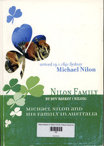
Book, Bev Rasker, Nilon family. Michael Nilon and his family in Australia, 2000
... Narre Warren and District Family History Group 110 High Street Berwick melbourne Michael Nilon Bolong (NSW) Cootamundra (NSW) In the early 19th Century rural Ireland was experiencing severe economic and social problems Population continued to grow as couples married at 16 or 17 and proceeded to have an average of 9 children. At the bottom end of the social scale labourers and the very smallest of farmers were in dire poverty ...In the early 19th Century rural Ireland was experiencing severe economic and social problems Population continued to grow as couples married at 16 or 17 and proceeded to have an average of 9 children. At the bottom end of the social scale labourers and the very smallest of farmers were in dire poverty. For the more comfortable farmers with 20 acres or so circumstances were better as they were in a position to grow additional crops which generated extra valuable income. Crop failures in 1822 and 1837 and again in 1845 to 1848 brought about unendurable hardship and famine. It was against this backdrop that Michael Neylon (Nilon) left his native Benvoran, Kilmurry McMahon Co Clare in search of opportunity and a better life. Now Beverley Rasker (nee Nilon) has fully researched his arrival in Australia in 1841 and she has taken up his story and that of his many descendants. Having communicated with Beverley for some time, I eventually had the pleasure of meeting her in September 2000, during her 2nd trip to Ireland in connection with her research. She has now put together an excellent record of interesting and informative material, which indeed makes us all proud of the achievements of the Neylon (Nilon) family. As we say in Irish'Molann an obair an fear' Sean Neylon, Kilkee, Co Clare Ireland. November 2000non-fictionIn the early 19th Century rural Ireland was experiencing severe economic and social problems Population continued to grow as couples married at 16 or 17 and proceeded to have an average of 9 children. At the bottom end of the social scale labourers and the very smallest of farmers were in dire poverty. For the more comfortable farmers with 20 acres or so circumstances were better as they were in a position to grow additional crops which generated extra valuable income. Crop failures in 1822 and 1837 and again in 1845 to 1848 brought about unendurable hardship and famine. It was against this backdrop that Michael Neylon (Nilon) left his native Benvoran, Kilmurry McMahon Co Clare in search of opportunity and a better life. Now Beverley Rasker (nee Nilon) has fully researched his arrival in Australia in 1841 and she has taken up his story and that of his many descendants. Having communicated with Beverley for some time, I eventually had the pleasure of meeting her in September 2000, during her 2nd trip to Ireland in connection with her research. She has now put together an excellent record of interesting and informative material, which indeed makes us all proud of the achievements of the Neylon (Nilon) family. As we say in Irish'Molann an obair an fear' Sean Neylon, Kilkee, Co Clare Ireland. November 2000michael nilon, bolong (nsw), cootamundra (nsw) -
 Bendigo Historical Society Inc.
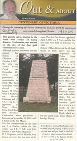
Newspaper - Newspaper articles by Ken Arnold, Out &About, 2000 - 2003
... Street Bendigo goldfields Ken Arnold is a Bendigo author and publisher. Events Monuments Historical sites Landmarks A series of one hundred and thirty-five articles written by Ken Arnold and published in the Bendigo Weekly between 2000 and 2003. Each article has a topic or theme and includes historical information and details. Each article includes a photograph. The articles are stored in a red vinyl covered two ring A5 folder. Index below. Number Article Name Date 1. Centenary of Victoria 19.5.00 2. Storm Water Drain 26.5.00 3. Granite Rollers 2.6.00 4. Poverty ...Ken Arnold is a Bendigo author and publisher.A series of one hundred and thirty-five articles written by Ken Arnold and published in the Bendigo Weekly between 2000 and 2003. Each article has a topic or theme and includes historical information and details. Each article includes a photograph. The articles are stored in a red vinyl covered two ring A5 folder. Index below. Number Article Name Date 1. Centenary of Victoria 19.5.00 2. Storm Water Drain 26.5.00 3. Granite Rollers 2.6.00 4. Poverty Mine 9.6.00 5. Golden Monument. St Arnaud 16.6.00 6. Turner Statue 7.7.00 7. Gold Monument. High St Golden Square 30.6.00 8. Gold Monument. Howard Square Bendigo 14.7.00 9. Lansell Statue 21.7.00 10. Shelbourne West School 18.8.00 11. Mologa’s State Schools 25.8.00 12. Salinity Stone. Pyramid Hill 1.9.00 13. Cairn. Carisbrook 8.9.00 14. Commemorative Markers. Taradale 15.9.00 15. Burke Monument. Castlemaine 22.9.00 16. Cairn. Harcourt area 29.9.00 17. Cairn Marks Gold Route 6.10.00 18. Volcanic Rock Cairn. Woodstock 13.10.00 19. Garfield Water Wheel 20.10.00 20. Anticline. Castlemaine 27.10.00 21. Lawson Bridge 10.11.00 22. Plaque. Sutton Grange area 17.11.00 23. Memorial Cairn. Maryborough 1.12.00 24. Lonely Grave 8.12.00 25. Moonlight Flat Church 5.1.01 26. Historic Church. Near Tullaroop reservoir 12.1.01 27. Granite Statue. Castlemaine 19.1.01 28. Marker. Near Tullaroop reservoir 25.1.01 29. Church Site. Mologa 2.2.01 30. Church Site. Mologa 9.2.01 31. Plaque. Mologa 16.2.01 32. Mincha School 23.2.01 33. Historic Marker. Mincha 2.3.01 34. Expedition Marker. Pyramid Hill 9.3.01 35. Irrigation Marker. Tragowel 16.3.01 36. Mologa School Sites 23.3.01 37. Cairn. Pyramid Hill 30.3.01 38. Plaque. Pyramid Hill 6.4.01 39. Bristol Hill Lookout Tower. Maryborough 12.4.01 40. Eppalock Reservoir 20.4.01 41. Colbinabbin Cairn 27.4.01 42. Mount Macedon Cross 4.5.01 43. Memorial Gateway. Macedon 11.5.01 44. Cairn. Daylesford 18.5.01 45. Grave. Carlsruhe 25.5.01 46. Water Tower. Elmore 1.6.01 47. State School Site. Glenalbyn 8.6.01 48. Cairn. Kanya 15.6.01 49. Lonely Grave. Wedderburn 22.6.01 50. Church Cairn. Glenalbyn 29.6.01 51. Kamarooka School 6.7.01 52. Granite Marker. Moyston 13.7.01 53. Memorial Park. Kerang 20.7.01 54. Water Plaque. Bears Lagoon 27.7.01 55. Cemetery. Bears Lagoon 3.8.01 56. Race Monument 10.8.01 57. Cairn. Pyalong 17.8.01 58. Cairn. In memory of Edward Parker 24.8.01 59. Mt Macedon 31.8.01 60. Mt Macedon Cairn 7.9.01 61. Expedition Pass. Chewton 14.9.01 62. Granite Archway. St Arnaud 21.9.01 63. Stuart Mill School Site 28.9.01 64. School Site. Beazley’s Bridge 5.10.01 65. Fosterville 12.10.01 66. Barnadown 19.10.01 67. Salisbury School Site 26.10.01 68. Cricket History at Wattle Flat 2.11.01 69. School Site. Waterloo Plains 9.11.01 70. Carapooee School Site 11.01 71. Turkish Gun. Maldon 11.01 72. Kooreh 30.11.01 73. Marnoo East School 7.12.01 74. Bulgana Site 14.12.01 75. Emu School 21.12.01 76. Kooroocheang 4.1.02 77. Church Site. Gre Gre North 11.1.02 78. Carmens Tunnel. Maldon 18.1.02 79. Monument. Maldon 25.1.02 80. Woodfull Plaques. Maldon 1.2.02 81. Carapooee. St Peters Anglican Church 8.2.02 82. Cairn. Kingower 15.2.02 83. Cob & Co Stopover. Rheola 22.2.02 84. Flynn Monument 1.3.02 85. The Welcome Stranger. Moliagul 8.3.02 86. Campbell’s Creek Reserve 15.3.02 87. Mine. Fryerstown 22.3.02 88. Escott Grave. Near Chewton 28.3.02 89. School No 808. Kurting area 5.4.02 90. Graves. Bendigo Creek 10.5.02 91. School. Fish Point, Benjeroop North 17.5.02 92. Old Township. Diggora 24.5.02 93. Diggora West (1) 31.5.02 94. Diggora West (2) 7.6.02 95. School No 2735. Gower East 14.6.02 96. Pannoomilloo 21.6.02 97. Kamarooka Settlement 28.6.02 98. Mincha West State School No 1931 5.7.02 99. Bridges. Arnold 12.7.02 100. Woodvale 19.7.02 101. A Famous Son of Raywood. Jack Donaldson 26.7.02 102. Tandarra Area Schools 2.8.02 103. Dingee 9.8.02 104. Avonmore 30.8.02 105. Myola East School 6.9.02 106. Colbinabbin West 13.9.02 107. Colbinabbin West School 20.9.02 108. Runnymede area 27.9.02 109. Wanalta 4.10.02 110. School Sites. Between Wanalta and Carop 11.10.02 111. Burramboot 18.10.02 112. Kangaroo Chair. 25.10.02 113. Mincha South 1.11.02 114. Woodlands Church 8.11.02 115. School site. Sylvaterre 15.11.02 116. Terrick Terrick 22.11.02 117. Leitchville 29.11.02 118. Pennyweight Cemetery. Castlemaine 6.12.02 119. Mincha Area 13.12.02 120. Musk School 20.12.02 121. Dowie Park. Carisbrook 3.1.03 122. Neereman School Site 10.1.03 123. Bald Rock 17.1.03 124. Sylvaterre School Site 24.1.02 125. Carlsruhe 31.1.02 126. Athenaeum. Maldon 7.2.03 127. School. Mincha West 14.2.03 128. Yarraberb 21.2.03 129. Settlement Marker. Ravenswood Estate 28.2.03 130. Comini Reserve. Ravenswood 7.3.03 131. Ironbark and Gold Track. Whroo 14.3.03 132. Burke and Wills Obelisk. Castlemaine 21.3.03 133. James Cook Statue. Myers St Bendigo 28.3.03 134. St Marys Church. Axedale 4 .4.03 135. Butter Factory Site. Warragamba 11.4.03 events, monuments, historical sites, landmarks -
 Ballarat Tramway Museum
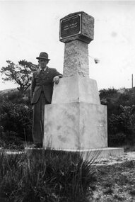
Photograph - Black & White Photograph/s, Wal Jack, Wal Jack at Poverty Point Monument, Sept. 1946
... Photo of a man (Wal Jack) standing by the Gold Monument at Poverty Point at the rear of Main Street Ballarat East. Monument looks new or recently cleaned up. ...Ballarat Tramway Museum South Gardens Reserve Wendouree Parade Ballarat Ballarat goldfields Photo of a man (Wal Jack) standing by the Gold Monument at Poverty Point at the rear of Main Street Ballarat East. Monument looks new or recently cleaned up. ...Photo of a man (Wal Jack) standing by the Gold Monument at Poverty Point at the rear of Main Street Ballarat East. Monument looks new or recently cleaned up. Photo taken Sept. 1946.Has a close association with Wal Jack, an avid collector of Ballarat Tramway and other tramway and railway materials.Black and white photographic print with hand written note on the rear.On rear in ink "Gold Monument at rear of Main Street Ballarat East. / First gold discovered in Ballarat 1851 / Sept 1946." In Wal Jack's handwriting.trams, tramways, ballarat, gold monument, poverty point -
 City of Ballarat
Artwork, other - Public Artwork, The Pioneer Miner's Monument, 1951
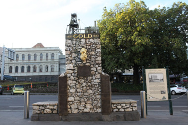
... City of Ballarat The Phoenix 25 Armstrong Street South Ballarat goldfields The Pioneer Miners’ Monument marks the very first finding of gold at Poverty Point in 1851. ...The Pioneer Miners’ Monument marks the very first finding of gold at Poverty Point in 1851. The quartz structure features a replica of the 62.8kg Welcome Nugget – the world’s largest at the time, found in Ballarat in 1858. The original was once displayed, and local mothers would sit their babies on top for luck. The artwork tells the story of gold discovery with plaques and dates of some of the more famous gold nuggets finds in Ballarat and is a reminder that these gold discoveries changed the world for Australians. The monument is of aesthetic and historical significance to the people of BallaratFitted copper miniature poppet head set atop a rough made plinth in Quartz and concrete mortar. A copy of the Welcome Nugget (Ballarat) is affixed to the front of the memorial. Includes several plaques listing the nuggets, the companies involved, the shop that paid for the last repair. THIS MONUMENT WAS ERECTED/ BY THE BALLARAT HISTORICAL/ SOCIETY TO COMMEMORATE THE/ FINDING OF GOLD AT POVERTY/ POINT 21ST AUGUST 1851 AND IS/ DEDECATED TO THE MEMORY OF/ PIONEER MINERS OF BALLARATgold, ballaraat, gold rush -
 Robin Boyd Foundation
Document - Manuscript, Robin Boyd, Looking at Australia’s Future, c. 1967
... Robin Boyd Foundation 290 Walsh Street South Yarra melbourne Discusses American technological advancement and American tendency to look forward; Australia is 15 years behind and should be more forward looking; Australian private affluence and public poverty, motor cars, expressways and roads. ...Discusses American technological advancement and American tendency to look forward; Australia is 15 years behind and should be more forward looking; Australian private affluence and public poverty, motor cars, expressways and roads. America is described as looking to a future beyond cars; Boyd proposes that Australia skips expressway building. Discusses tourism, the Australian accent, imagining 2000AD, Archigram's Plug-In City, anti-city, integrate bush into the city - the gumtree aesthetic.Typewritten (c copy), quarto, 29 pages. (Two copies plus one incomplete version with 13p)Incomplete one contains pencil editsfuture, america, henry ford, automobiles, road development, destruction of old buildings, destruction of nature, tourism, great barrier reef, australian accent, globalisation, isolationism, canada, new zealand, archigram, athens, los angeles, suburbia, heidelberg school, diggers, robin boyd, manuscript -
 Robin Boyd Foundation
Document - Manuscript, Robin Boyd, The Sad State of India’s `Canberra', 1964
... Robin Boyd Foundation 290 Walsh Street South Yarra melbourne Boyd writes about his opinion on Le Corbusier's Chandigarh and compares the qualities between the newly built city with Canberra. While Boyd praises Le Corbusier's plan, he also comments on the contrast of the grand buildings (Secretariat, Parliament and High Court) situated among the poverty that is ever present, which ultimately affects the image of Chandigarh. ...Boyd writes about his opinion on Le Corbusier's Chandigarh and compares the qualities between the newly built city with Canberra. While Boyd praises Le Corbusier's plan, he also comments on the contrast of the grand buildings (Secretariat, Parliament and High Court) situated among the poverty that is ever present, which ultimately affects the image of Chandigarh. This manuscript of Boyd's weekly newspaper column in 'The Australian' was published with the title 'The City of Sordid Splendor' on 28.06.1964. Original manuscript of an article published as 'The City of Sordid Splendor' in 'The Australian' 28.06.1964Typewritten, quarto, 5 pagescanberra, chandigarh, le corbusier, punjab, india, robin boyd, manuscript, ohm2022, ohm2022_16