Showing 2831 items matching public buildings
-
 Kew Historical Society Inc
Plan - Subdivision Plan, Riversdale Estate, 1939
... at right lists the major public buildings in the area: Burnely... by the subdivision). The Locality Plan at right lists the major public ...The Kew Historical Society collection includes almost 100 subdivision plans pertaining to suburbs of the City of Melbourne. Most of these are of Kew, Kew East or Studley Park, although a smaller number are plans of Camberwell, Deepdene, Balwyn and Hawthorn. It is believed that the majority of the plans were gifted to the Society by persons connected with the real estate firm - J. R. Mathers and McMillan, 136 Cotham Road, Kew. The Plans in the collection are rarely in pristine form, being working plans on which the agent would write notes and record lots sold and the prices of these. The subdivision plans are historically significant examples of the growth of urban Melbourne from the beginning of the 20th Century up until the 1980s. A number of the plans are double-sided and often include a photograph on the reverse. A number of the latter are by noted photographers such as J.E. Barnes.The Riversdale Estate in Hawthorn created a subdivision of 20 allotments bordering on Riversdale Road and Riversdale Court (which was created by the subdivision). The Locality Plan at right lists the major public buildings in the area: Burnely Horticultural Gardens, Hawthorn Tram Depot and Railway Station, Scotch College and the River Yarra and The Boulevard.subdivision plans - hawthorn, riversdale estate -
 Port Melbourne Historical & Preservation Society
Document - DVD, Public Records Office Victoria (PROV), Masonic Hall Port Melbourne. Public Building file, 1967 - 1974
... Masonic Hall Port Melbourne. Public Building file...COPYRIGHT PROV Masonic Hall Port Melbourne. Public... Melbourne. Public Building file COPYRIGHT PROV Masonic Hall Port ...COPYRIGHT PROV Masonic Hall Port Melbourne. Public Building file. DVD containing 10 pages of images of documents to and from the Public Health Department regarding specifications and plans for the Masonic Hall in Liardet St, Port Melbourne in 1917. Plus renewal of registration forms in 1922, 1937, 1941societies clubs unions and other organisations, built environment, health - general health, masonic hall, william howe -
Tatura Irrigation & Wartime Camps Museum
Folio, Tatura Mechanics Institute, Jun-01
... public building... public building victory hall documents reports ...Mechanics Institute Hall opened 1881 was Tatura's first public buildingPhotographic and photocopiedrecords of archival materials covering development 1881-1972, 1977-1983victory hall, documents, reports -
 Buninyong & District Historical Society
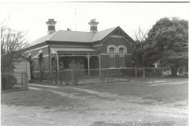
Photograph - B/W photograph, Mr C J Brooks, Former Police Station and residence, Scott St. Buninyong, July 1993
... Historic public building, built by Richard Rennie... and Residence, built by Richard Rennie c1880, brick building, L-fronted ...Historic public building, built by Richard Rennie, prominent local builderHistoric BuildingB/W Photo of former Police Station and Residence, built by Richard Rennie c1880, brick building, L-fronted, verandah, rendered cornice and window cappings.buninyong, police station, richard rennie, streetscape, scott st -
Port Melbourne Historical & Preservation Society
Document - DVD, Public Records Office Victoria (PROV), Seamen's Mission (230 Rouse St) Port Melbourne, Public Building file, 1906
... Seamen's Mission (230 Rouse St) Port Melbourne, Public... Melbourne, Public Building file. DVD containing 14 pages of images... (230 Rouse St) Port Melbourne, Public Building file COPYRIGHT ...NB this does not relate to the Beach and Nott Institute, but to a separate one from Temperance Hall that leased premises in 1906COPYRIGHT PROV Seamen's Mission (230 Rouse St) Port Melbourne, Public Building file. DVD containing 14 pages of images of documents between Rev B Cozens and the Public Health Department regarding conversion of four rented rooms into a Seamen's Mission at 230 Rouse St, Port Melbourne in 1906built environment, transport - shipping, missions to seamen, societies clubs unions and other organisations, rev b cozens -
 Bacchus Marsh & District Historical Society
Album, Jeremeas Family Album of Photographs of Bacchus Marsh and District in 1883 by Stevenson and McNicoll
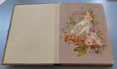
... in Bacchus Marsh, public buildings like the Court House and Bacchus..., public buildings like the Court House and Bacchus Marsh Primary... in Bacchus Marsh, public buildings like the Court House and Bacchus ...In late 1883 the Melbourne based photographers Stevenson and McNicoll visited the Bacchus Marsh township and nearby districts. They are known to have been visiting the town in September 1883 and by November 1883 they were reported to have moved on to Myrniong and Ballan. During their visit they took numerous photographs. The images produced comprise scenes of shops and businesses in Bacchus Marsh, public buildings like the Court House and Bacchus Marsh Primary School, houses and their owners and several broader views of streets. The photos were then offered for sale. Photography businesses also sold albums for purchasers to display their photos.A unique and comprehensive set of images of people and places in the Bacchus Marsh town and district at a particular period in time, September-November 1883. This album of "carte de visites" photographs presents a rare compilation of the work of the Stevenson and McNicoll photography business. This team of photographers are known to have made several visits to towns and districts in the rural areas of Victoria and southern New South Wales in the 1880s and this album represents a very rare example of their non-portrait photography. The album is an example of the Victorian middle-class fashion to display family photographs for themselves and their visitors. These albums were often very expensive and in themselves evidence of the affluence of the family. They were made possible by the popularisation of photography as a social medium and were a forerunner of the coffee-table book. Medium sized leather-bound album, brown, front cover engraved with gold tooling in a starburst pattern. Pages are gold-lined. The inside front and end covers are in pale blue silk embossed with a gold floral pattern. The metal locking clasp is broken. The front page has a floral wreath of roses and forget-me-nots and a dragon-fly. The word "Album" is in the centre of the wreath, printed in gold in Gothic print. There are nine pages with pockets for four 65mm x 105mm sized "carte de visites" style photographs. Several feature pages have a single pocket for a larger photograph, or double pockets, possibly designed for family portraits. These portrait pages are also decorated with floral wreaths and insects, reflecting the theme of the frontispiece page. The smaller photos in the album were taken by the Melbourne photographers Stevenson and McNicoll, There are 48 of these smaller images. The images were created around September 1883 when photographers for Stevenson and McNicoll are known to have visited Bacchus Marsh and district. The images comprise scenes of shops and businesses in Bacchus Marsh, public buildings like the Court House and Bacchus Marsh Primary School, houses with their owners and several broader views of streets. References to various photos being created and being available for sale are mentioned in the Bacchus Marsh Express newspaper during September to November 1883. Each smaller photo has printed on the verso: Light & Truth. Copies of this Portrait can be had at any time by sending the Name and Post Office Money Order or Stamps for the amount of order to Stevenson & McNicoll, late Benson & McNicoll, Photographers. 108 Elizabeth Street, Melbourne.bacchus marsh vic. history, streetscapes, shops bacchus marsh vic., roads and streets bacchus marsh vic., stevenson and mcnicoll photographers, stevenson and mcnicoll 1883 photographs of bacchus marsh and district -
 Hume City Civic Collection
Photograph, Late 1980's
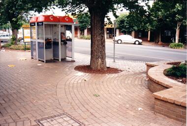
... occurred on public buildings... occurred on public buildings vandalism evans street taxi ranks ...The series of seven photographs highlight examples of vandalism within the town centre precinct. Most of the vandalism occurred on public buildingsA coloured photograph of public telephones and the taxi rank in Evans Street. The telephone directories have been torn up an thrown around the brick pavement along with other litter. The trunk of an elm tree is in the middle of the photograph.vandalism, evans street, taxi ranks, public telephones, telstra, telecom, george evans collection -
Port Melbourne Historical & Preservation Society
Document - DVD, Public Records Office Victoria (PROV), Temperance Hall, Port Melbourne, Public Building file, 1890 - 1963
... Temperance Hall, Port Melbourne, Public Building file...COPYRIGHT PROV Temperance Hall, Port Melbourne, Public... PROV Temperance Hall, Port Melbourne, Public Building file ...COPYRIGHT PROV Temperance Hall, Port Melbourne, Public Building file. DVD containing 25 pages of images of letters, documents and plans concerning the Temperance Hall, corner Nott and Liardet Streets, Port Melbourne from 1890 to 1963, belonging to the Independent Order of Rechabites. 1963 documents relate to the sale of the building to Port Melbourne Council for use as an Elderly Citizens Centrebuilt environment - civic, local government - city of port melbourne, societies clubs unions and other organisations, health - general health, port melbourne temperance hall, edward clark, town clerks, senior citizens centre, liardet community centre -
 Cheese World Museum
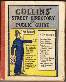
Book, Queen City Printers Pty Ltd, Collins Street Directoryand Publice Guide: 8th Edition
... each/CONTENTS/ Suburban Maps/Street Indices/Public Buildings... Maps/Street Indices/Public Buildings/Tourist Information ...The Percy Uebergang family lived at Tooram Park, Allansford from 1912 until 1992. This booklet was part of the collection of items given into the care of the Cheese World Museum. Uebergang catalogue No. -not listed White hard cover pocket-sized street directory book with red cloth spine. The front cover has a blue and yellow background with title, contents, edition listed and a policeman in a blue uniform. The back cover has information in black print. Melbourne and suburbs maps throughout. 439 pages.COLLINS' STREET DIRECTORY/AND/PUBLIC GUIDE/8th Edition/2/6 each/CONTENTS/ Suburban Maps/Street Indices/Public Buildings/Tourist Information and Holiday Notes/Weights and Measures/Postal Rates/Calendar/Conversion Tables/Justices of the Peace/And other useful and up-to-date matterallansford, uebergang, street directory, public guide, collins, melbourne, maps, tourist information, queen city printers pty ltd, almanacs, local history -
 Robin Boyd Foundation
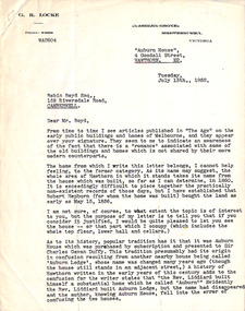
Letter, G. R. Locke, G R Locke to Robin Boyd, 15.07.1952
... newspaper articles on early public buildings and homes. This letter... on early Melbourne public buildings and homes, the writer ...The letter writer G. R. Locke has read Robin Boyd's newspaper articles on early public buildings and homes. This letter tells Boyd about the historic home "Auburn House", 4 Goodall St Hawthorn, established for Robert Hepburn with land purchased in 1856. It also tells of the confusion with neighbouring house "Auburn Lodge". Since Boyd writes on early Melbourne public buildings and homes, the writer is inviting Boyd to view the house. It is not known whether Robin Boyd took up the invitation. In 1960 it was included in the National Trust Register. -
 Hume City Civic Collection
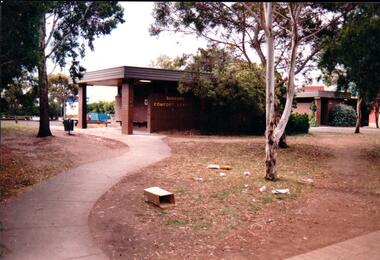
Photograph, Late 1980's
... occurred on public buildings. The toilet block was demolished... precinct. Most of the vandalism occurred on public buildings ...The series of seven photographs highlight examples of vandalism within the town centre precinct. Most of the vandalism occurred on public buildings. The toilet block was demolished in the late 1990's to make way for further expansion of the retail shopping centre in Sunbury.A coloured photograph of the Sunbury Comfort Station which was erected on a section of public land in Evans Street between the post office and Sunbury Shopping Square. The brown brick building has an open porch on one side and a curved concrete path leads from the street to the building. A smaller block is in the background and a grassed ared with trees is in the foreground with rubbish thrown across the grass.vandalism, public toilet blocks, evans street, sunbury comfort station, shire of bulla, george evans collection -
 Eltham District Historical Society Inc
Photograph, Jim Connor, Avenue of Honour, Main Road, Eltham, 3 Apr 2021
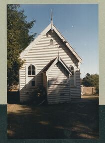
... . The Courthouse is the oldest public building in the shire. It was built... Shire Council. The Courthouse is the oldest public building ...Former Eltham Courthouse, 730 Main Road immediately prior to major restoration works undertaken by Nillumbik Shire Council. The Courthouse is the oldest public building in the shire. It was built in 1860 and ceased operations as part of the Court of Petty Sessions in 1985.Tomorrow's history documented todayeltham, jim connor collection, main road, eltham gateway, eltham courthouse, eltham justice precinct, avenue of honour -
 Kew Historical Society Inc
Map, MMBW, River Yarra Beautification Schemes, c.1913
... are not represented. Public buildings and institutions are clearly represented... by this date yet numerous streets are not represented. Public buildings ...The Melbourne and Metropolitan Board of Works (MMBW) was established by an act of the Victorian Parliament in 1890 to prepare for and to implement a sewerage and water reticulation system across what was then inner Melbourne, its surrounding and middle distance suburbs, including Kew. The MMBW was disbanded in 1991.The map collection of the Kew Historical Society has at its core the historic maps assembled and originally stored in the City Engineer's Department of the City of Kew. These include maps in a number of scales. The vast majority of maps were produced by the MMBW in the first two decades of the twentieth century, and are solid working maps, backed by linen for durability. These maps are historically significant to Kew, the City of Boroondara and to the history of the development of state utilities in Victoria. A number of the Kew maps have additional details added by former municipal officers, including the levels reached by various floods. As these were working documents, information was added to them long after the period of their initial production and distribution.Map of the City of Kew showing part of the River Yarra Beautification Schemes. The map shows development to date and the flood levels reached in 1923 and 1924. This map may have been adapted from an earlier map, as most development in central Kew and Studley Park had occurred by this date yet numerous streets are not represented. Public buildings and institutions are clearly represented and named on the map as are significant public transport infrastructure (eg the Outer Circle railway).MELBOURNE AND METROPOLITAN BOARD OF WORKS / RIVER YARRA BEAUTIFICATION SCHEMES / SCHEME / SCALE 10 CHAINS TO AN INCHmelbourne & metropolitan board of works, mmbw maps, mmbw plans, city of kew, flood levels -- kew (vic.), cartography -
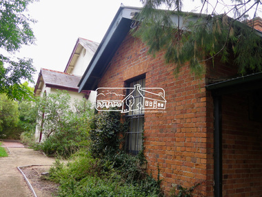
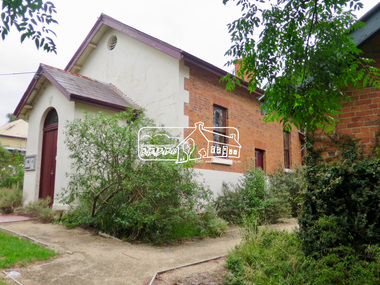
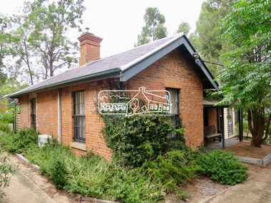
 University of Melbourne, Burnley Campus Archives
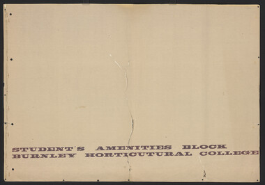
Plan, D.C. Bradbury, Student's Amenity Block Burnley Horticultural College, 1971
... Site Plan First Floor Elevations by D.C. Bradbury, Public.... Bradbury, Public Works Department Building Division, Victoria ...Site Plan First Floor Elevations by D.C. Bradbury, Public Works Department Building Division, Victoria 28.7.1971.students, amenities -
Tatura Irrigation & Wartime Camps Museum
Book, Public Library of NSW, 1943
... public building...To mark the completion of the Public Library Building, 1943... to the Building To mark the completion of the Public Library Building ...To mark the completion of the Public Library Building, 1943- Library of NSWA brief guide to the Buildingpublic building, books, history, local -
 South Gippsland Shire Council
Photographs, B & W, Country Roads Board Collection, 1965-1969
... images of several public buildings. Locations include Inverloch... of several public buildings. Locations include Inverloch, Dumbalk ...Collection of 57 black and white photographs of bridge and roadworks around the South Gippsland Shire 1965-1969. Includes images of several public buildings. Locations include Inverloch, Dumbalk & Meeniyan. Photographs taken by the Country Roads Board photographer. Mounted on cream textured card. Several have captions affixed. Each photograph is stamped and numbered on the reverse with the negative number used by the CRB. A prefix of 65, 67 & 69 is noted as part of the negative number which relates to the year the image was taken. -
 Eltham District Historical Society Inc
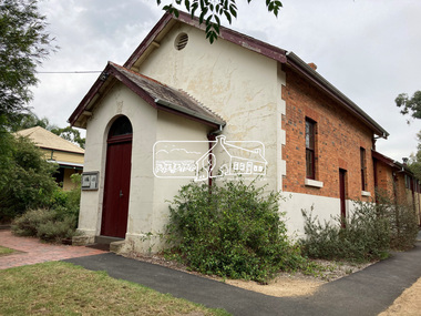
Photograph, Jim Connor, Avenue of Honour, Main Road, Eltham, 14 Jan 2017
... public building in the shire and the former Police Residence... public building in the shire and the former Police Residence ...Eltham Gateway, Eltham Justice Precinct featuring the former Eltham Courthouse (1860) at 730 Main Road, the oldest public building in the shire and the former Police Residence (1859) at 728 Main Road, Eltham - now part of the Local History Centre and home to Eltham District Historical SocietyTomorrow's history documented todayeltham, jim connor collection, main road, eltham gateway, eltham courthouse, eltham justice precinct, local history centre, police residence, avenue of honour -
 Eltham District Historical Society Inc
Photograph, Jim Connor, Avenue of Honour, Main Road, Eltham, 14 Jan 2017
... public building in the shire and the former Police Residence... public building in the shire and the former Police Residence ...Eltham Gateway, Eltham Justice Precinct featuring the former Eltham Courthouse (1860) at 730 Main Road, the oldest public building in the shire and the former Police Residence (1859) at 728 Main Road, Eltham - now part of the Local History Centre and home to Eltham District Historical SocietyTomorrow's history documented todayeltham, jim connor collection, main road, eltham gateway, eltham courthouse, eltham justice precinct, local history centre, police residence, avenue of honour -
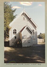 Uniting Church Archives - Synod of Victoria
Photograph, 1986
... Shires as a major and early public building in both districts... public building in both districts. The church may be the oldest ...Tynong North former Methodist Church, originally known as Christ Church, Berwick, has been an important community meeting place from c1870 and is significant to the Cardinia and Casey Shires as a major and early public building in both districts. The church may be the oldest (in part) public building in Cardinia Shire. This is a simple gabled church, clad with weatherboards and roofed with corrugated iron. It has a gabled porch with finial and distinctive arched openings (windows and doors) which may be indicative of its reputed early date (c1870), as linked with its classical styling. The windows have multi-paned glazing and the roof gable retains its finial. The concrete stumps and lack of mature planting around the church confirm that it has been moved to the site and restumped. Ref: https://vhd.heritagecouncil.vic.gov.au/places/30143/download-reportColour exterior view of the Tynong North Uniting Church, Clarke Rd. Tynong. The image shows a timber church with a porch.tynong north uniting church -
 Whitehorse Historical Society Inc.
Document, Koonung Mullum Forestway Association, 1998
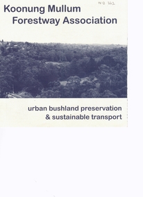
... . Improving public transport instead of building new freeways..... Improving public transport instead of building new freeways ...Improving public transportPamphlet suggesting a different vision for transport. Improving public transport instead of building new freeways.Improving public transport environment, koonung creek, mullum mullum creek, freeway, transport, koonung mullum forestway association -
 Kiewa Valley Historical Society
Folder - Early Photos of Mt Beauty
... Electric Scheme many houses were sold and the public buildings... and the public buildings handed over to the Alpine Shire. Mt Beauty has ...Mt Beauty township was built during the 1950's to house the employees of the State Electricity Commission working on the Kiewa Hydro Electric Scheme. After the completion of the Kiewa Hydro Electric Scheme many houses were sold and the public buildings handed over to the Alpine Shire. Mt Beauty has always been a tourist destination especially with its proximity to the ski fields at Falls Creek.This folder contains many early photos of Mt Beauty showing the construction town during its development during the Kiewa Hydro Electric Scheme and its early days of tourism. A3 size black plastic folder with clear plastic sleeves holding early black & white photos of Mt Beauty township. Also included are: 1. 3 foolscap pages -Nov., 1953 Kiewa Hydro-Electric Scheme Progress. 2. SECV Drawing Plan (No. K6242) of Mt Beauty House - 3 angles and floor plan, English Pre-cut Type 3B.ILA with note that all houses with prefix 3B are similar. 3. Orange, black and white pamphlet "Welcome to Kiewa" 4. Tourist postcard 'fold-up' of 11 postcards "Mt Beauty and the Kiewa Scheme, Victoria 5. Drawing Plan of 'Mt Beauty Housing. Use of Prefabricated Cubicles for Houses. Type C.1 6. Drawing Plan of 'Kiewa Scheme Mt Beauty Housing Type "G". 7. 5 pages on "Twelve Tips on Caring for Old Buildings 8. Booklet advertising Mt Beauty housing for sale including activities available in the area. (1960's) 9. List of Photos from SECV held by KVHS Some photos have handwritten labels mt beauty. secv. kiewa hydro electric scheme.tourism. housing. construction town. falls creek. -
 Warrnambool and District Historical Society Inc.
Booklet, Port Fairy Historical Society, Historic Buildings of Port Fairy, 2012
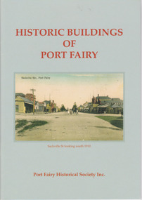
... in 1836, has an exceptional collection of public buildings... in 1836, has an exceptional collection of public buildings ...Port Fairy, a small town in Western Victoria established in 1836, has an exceptional collection of public buildings and dwellings dating from the 1840s. This booklet gives short descriptions of 58 of these historic buildings, many with accompanying photographs. These include many buildings in Gipps and Sackville Streets, the Powder Magazine, some hotels, the Drill Hall, Dublin House, the Port Fairy Cemetery and several schools and churches. This booklet is useful for those seeking quick information on the historic buildings in Port Fairy and for those wanting to undertake a walk around the town’s historic spots. TryBooking will show you the full breakdown on the Booking Payment Report and the Event Revenue Itemised Report so you can clearly see the ticket sales, credit card processing fee and the funds that are yours. Front cover: ‘Historic Buildings of Port Fairy, Port Fairy Historical Society Inc.’ Photograph on front cover: ‘Sackville Str. Port Fairy’, ‘Sackville St. looking south 1910’ Back cover map: ‘Port Fairy Historic Buildings’ warrnambool, port fairy, western victoria, historic buildings -
 Warrnambool and District Historical Society Inc.
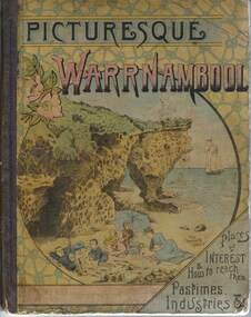
Book, Picturesque Warrnambool, 1891
... statistical evidence relating to public buildings and organisations... statistical evidence relating to public buildings and organisations ...This book presents a pictorial and written record of Warrnambool in 1891.It covers a wide range of topics. It provides statistical evidence relating to public buildings and organisations of that era, as well as basic information about district points of interest. The Mechanics Institute, the Common, Albert Park, the rivers, the Museum and the Sea Baths are all mentioned. The various drawings and advertisements provide a list of businesses which were prevalent at the time. As this book is one of only two complete copies documented to be still in existence, it is of considerable significance and importance to our collection. The drawings and text are artistically very much of the era and are aesthetically pleasing. Cardboard cover with picture of people on beach in tones of yellow, pink and blue sitting within a circle. Dark purple cloth spine binding. Back cover has drawing of Western Hotel. Pages are not numbered and there are a number of coloured and black and white drawings. Title is in dark purple and Warrnambool is in pink and blue tonesOn front cover “The Mermaids Caves” 1896. 1891 written in pen beneath roman numerals on bottom of title page. List of numbers written down title page in black pen.warrnambool, picturesque warrnambool, warrnambool 1891, -
 Warrnambool and District Historical Society Inc.
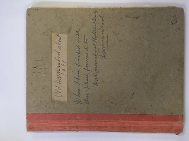
Book, Picturesque Warrnambool, C1891
... statistical evidence relating to public buildings and organisations... statistical evidence relating to public buildings and organisations ...This book presents a pictorial and written record of Warrnambool in 1891.It covers a wide range of topics. It provides statistical evidence relating to public buildings and organisations of that era, as well as basic information about district points of interest. The Mechanics Institute, the Common, Albert Park, the rivers, the Museum and the Sea Baths are all mentioned. The various drawings and advertisements provide a list of businesses which were prevalent at the time.As this book is one of only two complete copies documented to be still in existence, it is of considerable significance and importance to our collection. The drawings and text are artistically very much of the era and are aesthetically pleasing.Plain grey card cover with fabric binding. Handwriting on front cover and inside front cover. It contains a number of black and white and coloured plates depicting scenes of Warrnambool and the district. Approximately 70 pages.Old Warrnambool about 1891 hand written on label on front cover, underneath is also written “When I have finished with these please forward to Warrnambool Historical Society Warrnambool. D 77, 252 in bottom RHC of cover. picturesque warrnambool,, warrnambool 1891, -
 Federation University Historical Collection
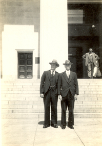
Photograph - black and white, Frank Wright and Mr Buckley in Auckland, New Zealand, Feb 1933
... to a large public building. At the top of the stairs is a panelled... leading to a large public building. At the top of the stairs ...Frank Wright was a renown resident of Smeaton, where he was born on 2 August 1901. He lived at Laura Villa, and attended Smeaton State School. His father William was a gold miner and his mother's name was Sarah. Their family won many singing and instrumental awards. Frank was tutored by Percy Code and was awarded a gold medal for the highest marks in the ALCM examinations in the British Colonies at the age of seventeen years. He became the Australian Open Cornet Champion by the age of eighteen. A year later, Frank conducted the City of Ballarat Band, and later the Ballarat Soldiers’ Memorial Band. He formed the Frank Wright Frisco Band and Frank Wright and his Coliseum Orchestra. These bands won many South Street awards, and Frank as conductor won many awards in the Australian Band Championship contest. In 1933 Frank Wright sailed to England to conduct the famous St Hilda’s Band and was later appointed Musical Director of the London County Council, where he organized many amazing concerts in parks, in and around the London district. He was made Professor of Brass and Military Band Scoring and conducted at the Guildhall of Music and Drama. Frank was often invited to adjudicate Brass Band Championships around Europe, in Australia, including South Street and in New Zealand. The Frank Wright Medal at the Royal South Street competition is awarded to an individual recognized as making an outstanding contribution to brass music in Australia.1). Black and white photograph of two men dressed in suits and hats, standing at the bottom of a flight of stairs leading to a large public building. At the top of the stairs is a panelled door to the left and to the right is a man standing with his hands on his hips. The man on the left is Frank Wright and the man on his right is Mr Buckley. The place is the museum in Auckland, New Zealand. 2). Black and white photograph of three men wearing suits and hats, walking along the pavement. In the background city buildings can be seen. The man on the left is Frank Wright and the place is Christchurch, New Zealand.1). Written in pencil on back - Frank Wright, Mr Buckley, Auckland (N.Z.) Museum, Feb 1933 2). Stamped on back - The Filmograph Co. (N.Z.), Majestic Theatre Buildings, Christchurch. (The paper has been cut in half, so half the written information is lost) Written in pencil of back - right, adjudicator, secretary N.Z.B.B.ch., Band Contest, 1933frank wright, mr buckley, auckland museum, magestic theatre buildings, brass band, christchurch, adjudicator