Showing 716 items matching "public land"
-
 Lakes Entrance Historical Society
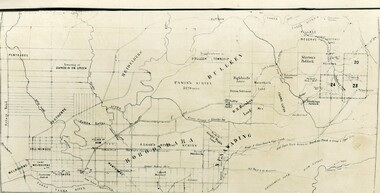
Map - Alpine Study Area Public Land and Blocks, Land Conservation Council
... Alpine Study Area Public Land and Blocks...Map showing public land and descriptive blocks in the Alpine area with names and numbers...Lakes Entrance Historical Society 4 Marine Parade Lakes Entrance gippsland study Land conservation Map No. 1 Map showing public land and descriptive blocks in the Alpine area with names and numbers Map Alpine Study Area Public Land and Blocks Land Conservation Council ...Map showing public land and descriptive blocks in the Alpine area with names and numbersMap No. 1study, land conservation -
Lakes Entrance Historical Society
Map - Public Land and Descriptive Blocks Gippsland Lakes Hinterland Area
... Public Land and Descriptive Blocks Gippsland Lakes Hinterland Area......public land...Lakes Entrance Historical Society 4 Marine Parade Lakes Entrance gippsland Topography public land Waterways Map shows the area of Macalister, Avon, Mitchell, Nicholson, Tambo, Colquhoun, Gippsland Lakes Map Public Land and Descriptive Blocks Gippsland Lakes Hinterland Area ...Map shows the area of Macalister, Avon, Mitchell, Nicholson, Tambo, Colquhoun, Gippsland Lakestopography, public land, waterways -
University of Melbourne, Burnley Campus Archives
Document - Report, Department of Conservation and National Parks and Public Land Division, Kooyoora State Park Proposed Management Plan, November 1991
... Produced by the Department of Conservation and Environment, Victoria, Bendigo Region and National Parks and Public Land Division...Department of Conservation and National Parks and Public Land Division....Produced by the Department of Conservation and Environment, Victoria, Bendigo Region and National Parks and Public Land Division Kooyoora State Park Proposed Management Plan Document Report Department of Conservation and National Parks and Public Land Division. ...kooyoora state park, management plan, department of conservation & environment, bendigo region -
 Orbost & District Historical Society
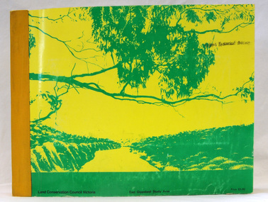
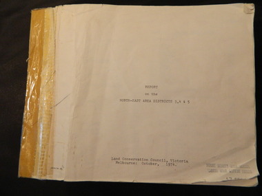
book, Report on the East Gippsland Study Area, June 1974
... East-Gippsland-Study-Area conservation public-land-use...As one of its three functions, it makes recommendations to the Minister for Planning and Environment with respect to the use of public land, in order to provide for the balanced use of land in Victoria. ...It contains folded maps and information on public land use in East Gippsland....East-Gippsland-Study-Area conservation public-land-use inside - "With Compliments - Bruce Evans, M.P." ...In 1961 Bruce Evans was elected to the Victorian Legislative Assembly as the member for Gippsland East. He was the party's deputy leader from 1964 to 1970 and its whip from 1970 until his retirement in 1992. "The Land Conservation Council was established by the Land Conservation Act 1970. As one of its three functions, it makes recommendations to the Minister for Planning and Environment with respect to the use of public land, in order to provide for the balanced use of land in Victoria. This report contains the Council’s final recommendations concerning the use of public land in the East Gippsland study area, the boundaries of which correspond to those of the Shire of Orbost. The recommendations in the text are grouped under major headings, such as Parks, State Forest, and so on. " The Council met on seven occasions during the year, and also made visits of inspection to each study area. The Chairman visited Shire Councils in study areas to explain the role and the functions of the Land Conservation Council and to invite submissions on the use of public land in these areas. This is the fourth annual report by the council. This is a useful research tool.A large book 236 pp book with a yellow / gold cover with a green bush scene . The binding is orange. It contains folded maps and information on public land use in East Gippsland.inside - "With Compliments - Bruce Evans, M.P."east-gippsland-study-area conservation public-land-use -
 Ringwood and District Historical Society
Map - Public Land Sale by Thomas Ham, 2000 Acres for Sale - Crown Sections 20, 23, 24 - Ringwood, Victoria - 1855
... Public Land Sale by Thomas Ham...Detailed description of lots for sale and navigational directions to the property from Richmond by Thomas Ham, Victorian public servant, map maker, publisher, lithographer and original Ringwood land owner. ...Inset map enlarging area between Yarra River and Dandenong Creek, with southern boundary of allotments later forming part of Oban Road, North Ringwood. 2000 Acres for Sale - Crown Sections 20, 23, 24 - Ringwood, Victoria - 1855 Map Public Land Sale by Thomas Ham ...Two 1850s surveyor's maps on cardboard backing showing area from Melbourne extending East beyond Bulleen and Nunawading. Detailed description of lots for sale and navigational directions to the property from Richmond by Thomas Ham, Victorian public servant, map maker, publisher, lithographer and original Ringwood land owner. Inset map enlarging area between Yarra River and Dandenong Creek, with southern boundary of allotments later forming part of Oban Road, North Ringwood.TRANSCRIPT: "This really valuable Property is now offered to the public for sale, in lots to suit purchasers at the Iow rate of £1 per Acre for 80 acres and upwards, and £1.10s per Acre for any smaller portion. Terms of payment Half Cash, Balance in 6 and 12 months, bearing 8 per cent interest. The Estate is well wooded with Gum, Cherry Tree and Stringy Bark, with Wattle in the valleys of the several creeks. Every lot is Staked and Trenched at the corners marked on the Plan thus - The Surveyor has carefully sub-divided the Property, in order to give every Farm a Creek for Water, Valley for Cultivation, and Hills for House and Grass Paddock. The ROADS have been very carefully laid out so as to give a firm, well drained, and nearly level road to each Homestead. Intending purchasers can readily find the property by the following directions, viz: Start from Richmond Bridge, at Hawthorne, then take the left-hand road to KEW. When at the "Woodman Inn", take the Cotham Road to the right, bearing due east, keep this Road, passing Trainor's "White Horse" Inn, and before you leave the fences, you will see calico bills (see margin) nailed to the Trees on the bush track leading to the Upper Yarra country, follow the Bills till you come to the SOUTH boundary line of the Property, which bears East and West (see Plan) where you will see Bills nailed up "THIS PROPERTY FOR SALE, etc." The Bills from Town lead direct to where Mr. Jull is erecting his Store, and arrangements have been made with him to show the lots to intending purchasers free of charge. At the respective corners of the lots the Bills are nailed up double, with numbers to denote the lot, and that the corner stake is adjacent. Any parties wishing to proceed to the property by way of BULLEEN will find Bills nailed on the Trees, commencing at the NEW INN, at "Wilson's Slip Rail." Keep this Track till you come to the Log Bridge, over the Deep Creek at Bloxhome's Paddock; go through the land now being cleared; keep the track over the hill till you come to an Iron House, you will then be on the property, which Iies to the North and East as per Plan. Follow the Bills till you come to Mr. Jull's Store, etc. etc. Further particulars can be had from the Agent for the Property. THOMAS HAM. " -
 Ringwood and District Historical Society
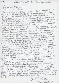
Letter, JK McCaskill objecting to the Bowling Club using further public reserve land
... JK McCaskill objecting to the Bowling Club using further public reserve land...JK McCaskill objecting to the Bowling Club using further public reserve land. Undated....JK McCaskill objecting to the Bowling Club using further public reserve land Letter ...1929 saw the establishment of the Ringwood Bowls Club initially located on the land now occupied by the Eastland Shopping Centre. It moved to its current location in Loughnan Road, Ringwood in 1997.JK McCaskill objecting to the Bowling Club using further public reserve land. Undated.city of ringwood bowls club, ringwood bowling club, ringwood bowls club, lawn bowls, bowling -
Save the Dandenongs League Inc.
Archive (item), Save the Dandenongs League Incorporated, Upper Yarra Valley and Dandenong Ranges Authority - Technical Report Series - Report No. 16 - 1988 - Planning for Public Land
... Upper Yarra Valley and Dandenong Ranges Authority - Technical Report Series - Report No. 16 - 1988 - Planning for Public Land...Upper Yarra Valley and Dandenong Ranges Authority - Technical Report Series - Report No. 16 - 1988 - Planning for Public Land Archive Save the Dandenongs League Incorporated ... -
Save the Dandenongs League Inc.
Archive (item), Save the Dandenongs League Incorporated, A Study of the Recreational Potential of Public Land in the Don Valley
... A Study of the Recreational Potential of Public Land in the Don Valley...Upper Yarra Valley and Dandenong Ranges Authority (UYVDRA) A Study of the Recreational Potential of Public Land in the Don Valley Archive Save the Dandenongs League Incorporated ...upper yarra valley and dandenong ranges authority (uyvdra) -
 Victorian Aboriginal Corporation for Languages
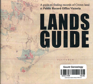
CD-ROM, Public Record Office Victoria, Lands guide : a guide to finding records of Crown land at Public Record Office Victoria, 2009
... Lands guide : a guide to finding records of Crown land at Public Record Office Victoria...A Guide to finding records of Crown land at Public Records Office Victoria....Victorian Aboriginal Corporation for Languages 33 Saxon Street Brunswick melbourne CD-ROM A Guide to finding records of Crown land at Public Records Office Victoria. Lands guide : a guide to finding records of Crown land at Public Record Office Victoria CD-ROM Public Record Office Victoria ...A Guide to finding records of Crown land at Public Records Office Victoria.CD-ROM -
 Kiewa Valley Historical Society
Report - Land Conservation Council x2, Land Conservation Council, Victoria Melbourne, April 1978, October 1974
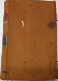
... ...public land...Land Conservation Act 1970 established the Land Conservation Council to investigate and recommend to the Minister use of public land in Victoria. It describes and assesses the natural resources:-Physiography, Geology, Topography, Land Systems, Outdoor Recreation, Public land and blocks. ...Kiewa Valley Historical Society Mount Beauty Information Centre 31 Bogong High Plains Rd Mt Beauty high-country Land Conservation Act 1970 established the Land Conservation Council to investigate and recommend to the Minister use of public land in Victoria. It describes and assesses the natural resources:-Physiography, Geology, Topography, Land Systems, Outdoor Recreation, Public land and blocks. ...Land Conservation Act 1970 established the Land Conservation Council to investigate and recommend to the Minister use of public land in Victoria. It describes and assesses the natural resources:-Physiography, Geology, Topography, Land Systems, Outdoor Recreation, Public land and blocks. Primary Production. Vegetation.North East Victoria includes the Kiewa Valley. This report gives an understanding of the development of the area.Thick heavy book with 312 pages with black and white photos. Back half has a folder with heavy cardboard attached to thick cardboard back cover. Inside folder are 9 maps with color each with a different title.Stamped on Front Cover: "Mount Beauty High School" Has a library borrowing slip at the back of the last page.land conservation council, environment, public land, kiewa valley, planning -
 Otway Districts Historical Society
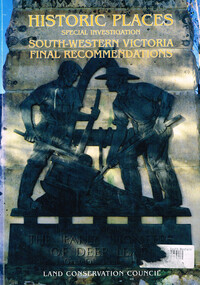
Book, Land Conservation Council, Historic places: special investigation: South-Western Victoria: Final recommendations, January 1997
... Land Conservation Council; Conservation; Historic places; Public land; Aborigines; South West Victoria;...The report also contains recommendations relating to general historic places management, the processes available in Victoria for the protection of historic places on public land, and Aboriginal historic places....The report also contains recommendations relating to general historic places management, the processes available in Victoria for the protection of historic places on public land, and Aboriginal historic places. Land Conservation Council; Conservation; Historic places; Public land; Aborigines; South West Victoria; Maps in plastic sleeve. ...The Land Conservation Council has carried out an investigation of historic places in public land in South-western Victoria. The report contains the Council's recommendations for the protection, management and future use of more than 700 historic places, out of 2200 places identified during the investigation. The places have been assigned to three categories, A, B and C, representing State, regional and local levels of significance. The report also contains recommendations relating to general historic places management, the processes available in Victoria for the protection of historic places on public land, and Aboriginal historic places.Historic places: Special investigation: South-Western Victoria: Final recommendations. Land Conservation Council. Land Conservation Council; Melbourne (Vic); January 1997. viii, 176 p.; illus.; maps. Soft cover. ISBN 0 7241 9290 5Maps in plastic sleeve.land conservation council; conservation; historic places; public land; aborigines; south west victoria; -
Lakes Entrance Historical Society
Map - Map 10 Land Tenure North Arm
... Map shows public land managed by East Gippsland Shire. ...Lakes Entrance Historical Society 4 Marine Parade Lakes Entrance gippsland Land management Environment Recreation Facilities Map shows public land managed by East Gippsland Shire. Public land managed by Dept N.R.E. ...Map shows public land managed by East Gippsland Shire. Public land managed by Dept N.R.E. Public land managed by Lakes Entrance Recreation Reserve Committee of Management. 3 pagesland management, environment, recreation facilities -
 Bendigo Historical Society Inc.
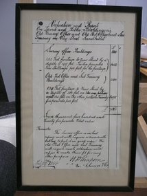
Document - VALUATION AND REPORT ON LAND AND PUBLIC BUILDINGS, 1888
... VALUATION AND REPORT ON LAND AND PUBLIC BUILDINGS...Framed document, valuation and report on land and public buildings vis old survey office and Post Office and sub Treasury in View Street Sandhurst, hand written in black ink and signed N P Simpson Feby 22nd 1888. ...Document VALUATION AND REPORT ON LAND AND PUBLIC BUILDINGS ...Framed document, valuation and report on land and public buildings vis old survey office and Post Office and sub Treasury in View Street Sandhurst, hand written in black ink and signed N P Simpson Feby 22nd 1888. Under glass in a thin black wooden frame.document, certificate, public buildings -
 Surrey Hills Historical Society Collection
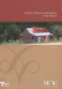
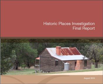
Book, Historic Places Investigation, Aug-16
... In March 2014, the then Minister for Environment and Climate change requested the Victorian Environmental Assessment Council (VEAC) to undertake an investigation into historic places on public land across Victoria. This final report completes VEAC's investigation....In March 2014, the then Minister for Environment and Climate change requested the Victorian Environmental Assessment Council (VEAC) to undertake an investigation into historic places on public land across Victoria. This final report completes VEAC's investigation....Surrey Hills Historical Society Collection 190A Canterbury Road Canterbury melbourne In March 2014, the then Minister for Environment and Climate change requested the Victorian Environmental Assessment Council (VEAC) to undertake an investigation into historic places on public land across Victoria. This final report completes VEAC's investigation. historiic buildings - victoria historic sites - victoria public lands - victoria veac In March 2014, the then Minister for Environment and Climate change requested the Victorian Environmental Assessment Council (VEAC) to undertake an investigation into historic places on public land across Victoria. ...In March 2014, the then Minister for Environment and Climate change requested the Victorian Environmental Assessment Council (VEAC) to undertake an investigation into historic places on public land across Victoria. This final report completes VEAC's investigation.In March 2014, the then Minister for Environment and Climate change requested the Victorian Environmental Assessment Council (VEAC) to undertake an investigation into historic places on public land across Victoria. This final report completes VEAC's investigation.historiic buildings - victoria, historic sites - victoria, public lands - victoria, veac -
Canterbury History Group
Document - List of significant trees, May 2001 - May 2003
... Lists of significant trees on public land and private property in Boroondara...Canterbury History Group 190A Canterbury Road Canterbury melbourne Canterbury Camberwell Deepdene Balwyn Kew Hawthorn Glen Iris Surrey Hills Trees Lists of significant trees on public land and private property in Boroondara Document List of significant trees ...Lists of significant trees on public land and private property in Boroondaracanterbury, camberwell, deepdene, balwyn, kew, hawthorn, glen iris, surrey hills, trees -
Lakes Entrance Historical Society
Book, Land Conservation Council, Victoria, Final Recommendations East Gippsland Study Area 1977, 1977
... A summary of the final recommendation for the adequate management and protection of public land in East Gippsland....Lakes Entrance Historical Society 4 Marine Parade Lakes Entrance gippsland Natural Resources Recreation Agriculture A summary of the final recommendation for the adequate management and protection of public land in East Gippsland. Final Recommendations East Gippsland Study Area 1977 Book Land Conservation Council, Victoria. ...A summary of the final recommendation for the adequate management and protection of public land in East Gippsland.natural resources, recreation, agriculture -
Whitehorse Historical Society Inc.
Article, Keep land for public, 2013
... Keep land for public...Article about site of former Nunawading primary School. Keep land for public Article Article ...Article about site of former Nunawading primary School.Article about site of former Nunawading primary School.Article about site of former Nunawading primary School.nunawading primary school no. 4190, former site -
 Bendigo Historical Society Inc.
Document - LANDS OFFICE, REPORTS OF SALES BY PUBLIC AUCTION, 1864 - 1892
... ... public land auctions...On spine on red rectangle ' Land sales by public auction' written in gold. On bottom of spine 'Lands and Survey' written in gold on black. ...History House 11 Mackenzie Street Bendigo goldfields PLACE Bendigo Sandhurst crown land public land auctions land sales. Lands and Survey Dept. ...Document: buff leather hard covered journal. On spine on red rectangle ' Land sales by public auction' written in gold. On bottom of spine 'Lands and Survey' written in gold on black. On base of spine '4' printed in black. Pages contain details of sales of crown lands by public auction Act 25, Victoria 145. Alphabetical index of counties inside front cover. 443 numbered pages. LH side columns, number, county, parish, section, allotment sold, unsold, price. RH page - improvements, purchaser, residence, amount, later sales have printed notices pasted in. Dated 27 April 1864 to 7 October 1892.Lands and Survey Dept.place, bendigo, sandhurst, crown land, public land auctions, land sales. -
 Kiewa Valley Historical Society
Report - Alpine Study Area Volume 2 Maps, Land Conservation Council, 1970s
... They provide a framework for use of Public Land in Victoria. The Land Conservation Council was established by the Land Conservation Act 1970....Maps include 1. Public land and descriptive blocks. 2. Physiography. 3. ...Maps include 1. Public land and descriptive blocks. 2. Physiography. 3. ...The Victorian Environmental Assessment Council and the former Environment Conservation Council (ECC) and Land Conservation Council (LCC) have completed 36 land use investigations over more than 35 years, including 27 regional reviews. They provide a framework for use of Public Land in Victoria. The Land Conservation Council was established by the Land Conservation Act 1970.These maps provide an assessment of the Alpine area at the time the maps were created. Some of the topics eg. Rainfall and water resources may change over the years thus providing a comparative analysis. Others may provide information for future development such as mineral exploration, building of a dam / tunnel etc.Blue box shaped folder containing 9 of 10 Maps of the Alpine Study Area produced by the Land Conservation Council. Maps include 1. Public land and descriptive blocks. 2. Physiography. 3. Topography. 4. Geology (missing). 5. Rainfall and water resources. 6. Vegetation 7. Land systems. 8. Recreation. 9. Primary production. 10. Minerals Ex library item. Stamped in red "Discarded From Stock / Swan Hill Regional Libraryalpine area, maps of alpine area, land conservation council -
 Camberwell Historical Society
Booklet (Item) - Report, Phil Honeywood, Historic Places Investigation Final Report, 2016
... Second and final report for the Historic Places Investigation, an investigation into historic places on public land across Victoria conducted in 2014....Camberwell Historical Society 25 Inglesby Road Camberwell melbourne Melbourne Victoria Council Second and final report for the Historic Places Investigation, an investigation into historic places on public land across Victoria conducted in 2014. ...melbourne, victoria, council -
Marysville & District Historical Society
THE TRIANGLE NEWS-VOL 36 NO 24-JULY 3 2009
... firewood strategy for public land...Marysville & District Historical Society 39 Darwin Street Marysville yarra-valley-and-the-dandenong-ranges marysville victoria australia german violinist lucas barr music & the arts marysville toorak uniting church what's on when buxton progress assocn buxton primary school murrindindi regional tourism assocn agm mrta marysville cricket club marysville & district lions club buxton strength training marysville central update vip visitor greg norman crossways inn the lolly shop council resource recovery centre wandin inner wheel club wandin rotary visitors to marysville our lady of assumption primary school cheltenham donations maryville temporary village advertisements councillor comment church notices marysville christian fellowship new beginners fellowship domestic firewood permits dse customer service centre firewood strategy for public land marysville medical clinic THE TRIANGLE NEWS-VOL 36 NO 24-JULY 3 2009 ...marysville, victoria, australia, german violinist lucas barr, music & the arts marysville, toorak uniting church, what's on when, buxton progress assocn, buxton primary school, murrindindi regional tourism assocn agm, mrta, marysville cricket club, marysville & district lions club, buxton strength training, marysville central update, vip visitor greg norman, crossways inn, the lolly shop, council resource recovery centre, wandin inner wheel club, wandin rotary, visitors to marysville, our lady of assumption primary school cheltenham donations, maryville temporary village, advertisements, councillor comment, church notices, marysville christian fellowship, new beginners fellowship, domestic firewood permits, dse customer service centre, firewood strategy for public land, marysville medical clinic -
Federation University Historical Collection
Book, Jacobs Lewis Vines Architects and Conservation Planners, Historic Sites Survey: Ballarat Study Area, 1980, 1980
... ...public land...Barker Library (top floor) Mount Helen goldfields This survey was commissioned by the Land Conservation Council, Australian Heritage Commission and the Ministry for Conservation historic sites ballarat Wendy jacobs miles lewis gary vines berringa buninyong creswick dunnstown fiery creek lal lal langi logan cathcart mount cole Mount Egerton nerrina gong gong wombat state forest railways explorers routes early roads land conservation council ausralian hertiage commission department of planning ICOMOS (Burra) Charter nigel lewis richard aitken freehold land public land langi ghiran New jubille mine birthday tunnel mine pitfield plains smythesdale buninyong company Mount Clear mt clear canadian gully Warrenheip Distillery thomas mitchell waterloo trawalla beaufort raglan internment camps forestry mining mining mt egerton Mary Hollick Collection Jubilee Mine Burra Charter Historica areas data form explorers Egerton Company Black Horse mine Mt Egerton Government Battery kaolin Mines Anderson Brothers Barkstead Anderson's Tramway Clarkesdale Berry Leads Birthday Tunnel Mine Berringa Warrenheip Australasian Company Mount Mercer Lanvi-Kal-Kal water race 114 page report on historic sites in the Ballarat region. ...This survey was commissioned by the Land Conservation Council, Australian Heritage Commission and the Ministry for Conservation 114 page report on historic sites in the Ballarat region. It includes information on sites, a schexdule of sites, silte selection and designated areas (ie around towns)historic sites, ballarat, wendy jacobs, miles lewis, gary vines, berringa, buninyong, creswick, dunnstown, fiery creek, lal lal, langi logan, cathcart, mount cole, mount egerton, nerrina, gong gong, wombat state forest, railways, explorers routes, early roads, land conservation council, ausralian hertiage commission, department of planning, icomos (burra) charter, nigel lewis, richard aitken, freehold land, public land, langi ghiran, new jubille mine, birthday tunnel mine, pitfield plains, smythesdale, buninyong company, mount clear, mt clear, canadian gully, warrenheip distillery, thomas mitchell, waterloo, trawalla, beaufort, raglan, internment camps, forestry, mining, mining, mt egerton, mary hollick collection, jubilee mine, burra charter, historica areas data form, explorers, egerton company, black horse mine, mt egerton government battery, kaolin mines, anderson brothers, barkstead, anderson's tramway, clarkesdale, berry leads, birthday tunnel mine berringa, warrenheip, australasian company, mount mercer, lanvi-kal-kal, water race -
Federation University Historical Collection
Book, Tourism at the University of Ballarat - 1996 AH&TE Conference: Historic Mining Site Management, 1996
... ...public land in victoria...Barker Library (top floor) Mount Helen goldfields Tourism at the University of Ballarat - 1996 AH&TE Conference: Historic Mining Site Management mary hollick public land in victoria heritage legislation commonwealth management issues list of key mining heritage trails preliminary market research survey locations university of ballarat, school of business Historic Mining Site Historic mining site management tourism mining heritage trails White soft covered folder. ...Tourism at the University of Ballarat - 1996 AH&TE Conference: Historic Mining Site ManagementWhite soft covered folder. mary hollick, public land in victoria, heritage legislation commonwealth, management issues, list of key mining heritage trails, preliminary market research, survey locations, university of ballarat, school of business, historic mining site, historic mining site management, tourism, mining heritage trails -
Ballarat Heritage Services
Book, Hepburn Shire Council Biodiversity strategy, 2018, 2018
... ...public land management...Biodiversity Shire of Hepburn Ricky Nelson Dja Dja Wurrung public land management Climate Change Habitat Corridors Biolink zones weed management 48 Page report on biodiversity in the Victorian Shire of Hepburn. ...48 Page report on biodiversity in the Victorian Shire of Hepburn. non-fictionbiodiversity, shire of hepburn, ricky nelson, dja dja wurrung, public land management, climate change, habitat corridors, biolink zones, weed management -
Lakes Entrance Historical Society
Book, Land Conservation Council Victoria, The Gippsland Lakes Land Use Strategy Plan 1978, 1985
... A review of public land use in the East Gippsland area, including natural resources, flora and fauna, recreation. ...Lakes Entrance Historical Society 4 Marine Parade Lakes Entrance gippsland Conservation Aboriginals Primary industry A review of public land use in the East Gippsland area, including natural resources, flora and fauna, recreation. ...A review of public land use in the East Gippsland area, including natural resources, flora and fauna, recreation. Contains photographs, maps statistics.conservation, aboriginals, primary industry -
 Anglesea and District Historical Society
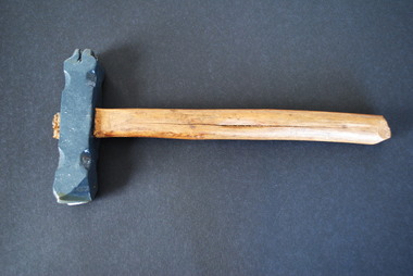
Forestry Branding Hammer, Unknown
... Probably used to mark trees on public land....Probably used to mark trees on public land. Forestry Branding Hammer ...Old logging stamp hammer, double-sided, iron head on wooden handle. F.C. on one end. Arrow on the other end. Probably used to mark trees on public land.F.C. on one end of head. Arrow on other end of head. Metal head painted grey.forestry commission, branding hammer -
Lakes Entrance Historical Society
Book, Land Conservation Council Victoria Alpine Area, 1977
... Report containing information from various sources relevant to the future use of public land in the alpine area of Victoria. History, climate, landform, vegetation, land use, are some of the aspects presented....Lakes Entrance Historical Society 4 Marine Parade Lakes Entrance gippsland Topography Vegetation Ruth Clark Report containing information from various sources relevant to the future use of public land in the alpine area of Victoria. History, climate, landform, vegetation, land use, are some of the aspects presented. ...Report containing information from various sources relevant to the future use of public land in the alpine area of Victoria. History, climate, landform, vegetation, land use, are some of the aspects presented.Ruth Clarktopography, vegetation -
Lakes Entrance Historical Society
Book, Land Conservation Council Victoria South Gippsland Area District 2, 1980
... Report describing and assessing the natural resources of the public land in the South Gippsland (Victoria) Study Area 2, comprising the Latrobe Valley, Strzelecki Range, South Gippsland coastal plains and all of Wilson's Promontory. ...Lakes Entrance Historical Society 4 Marine Parade Lakes Entrance gippsland Gippsland Topography Natural History Vegetation Ruth Clark Report describing and assessing the natural resources of the public land in the South Gippsland (Victoria) Study Area 2, comprising the Latrobe Valley, Strzelecki Range, South Gippsland coastal plains and all of Wilson's Promontory. ...Report describing and assessing the natural resources of the public land in the South Gippsland (Victoria) Study Area 2, comprising the Latrobe Valley, Strzelecki Range, South Gippsland coastal plains and all of Wilson's Promontory. Ruth Clarkgippsland, topography, natural history, vegetation -
Lakes Entrance Historical Society
Book, VEAC, Draft Paper on Historical Places Investigation, 2015
... In March 2014 the minister of environment and climate change requested VEAC to undertake an investigation into historic places on public land in Victoria. This draft paper initiated a public consultation after which a final report in 2016....Lakes Entrance Historical Society 4 Marine Parade Lakes Entrance gippsland Historic Sites In March 2014 the minister of environment and climate change requested VEAC to undertake an investigation into historic places on public land in Victoria. This draft paper initiated a public consultation after which a final report in 2016. ...In March 2014 the minister of environment and climate change requested VEAC to undertake an investigation into historic places on public land in Victoria. This draft paper initiated a public consultation after which a final report in 2016.historic sites -
Lakes Entrance Historical Society
Book, Land Conservation Council Victoria, Land Conservation Council East Gippsland Area Review, 1985
... Report describing the physical and biological aspects of the public land in the eastern corner of Victoria, predominantly the Orbost Shire. ...Lakes Entrance Historical Society 4 Marine Parade Lakes Entrance gippsland Parks Waterways Tourism Gippsland Report describing the physical and biological aspects of the public land in the eastern corner of Victoria, predominantly the Orbost Shire. ...Report describing the physical and biological aspects of the public land in the eastern corner of Victoria, predominantly the Orbost Shire. Many issues are covered in the report, including timber industry, national parks, waterways and tourism. Six mapsparks, waterways, tourism, gippsland