Showing 854 items matching "public parks"
-
 Port Melbourne Historical & Preservation Society
Letter - Department of Lands and Survey grant for improving public parks in Sandridge, Department of Lands and Survey, 19 Oct 1863
... Department of Lands and Survey grant for improving public parks in Sandridge...Handwritten letter from Dept of Lands and Survey 19.10.1863, notifying grant of £90/0/0 for the improving of public parks in Sandridge for 1863...Port Melbourne Historical & Preservation Society Port Melbourne Town Hall 333 Bay Street Port Melbourne melbourne Local Government - Borough of Sandridge Handwritten letter from Dept of Lands and Survey 19.10.1863, notifying grant of £90/0/0 for the improving of public parks in Sandridge for 1863 Letter Department of Lands and Survey grant for improving public parks in Sandridge Department of Lands and Survey ...Handwritten letter from Dept of Lands and Survey 19.10.1863, notifying grant of £90/0/0 for the improving of public parks in Sandridge for 1863local government - borough of sandridge -
 Kew Historical Society Inc
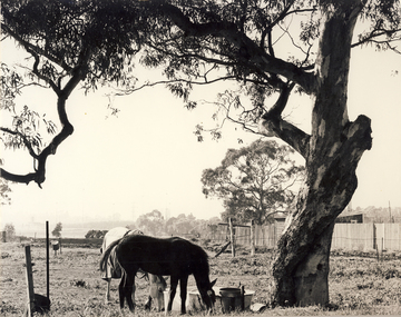
Photograph, City of Kew, Hays Paddock, Kew East, c.1980
... ...kew (vic) - public parks...The photos represent a snapshot in time. hays paddock - kew east (vic) kew (vic) - history kew (vic) - public parks kew (vic) - farming Enlarged photograph mounted on board, donated to the Kew Historical Society by the City of Kew on 10 April 1991. ...One of a series of photos created for an exhibition by the City of Kew of notable locations. The photos represent a snapshot in time.Enlarged photograph mounted on board, donated to the Kew Historical Society by the City of Kew on 10 April 1991.hays paddock - kew east (vic), kew (vic) - history, kew (vic) - public parks, kew (vic) - farming -
 University of Melbourne, Burnley Campus Archives
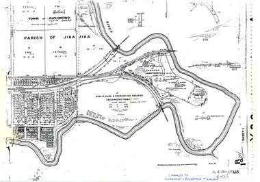
Plan, Allan & Tuxen et al, Public Park & Recreation Reserve (Richmond Park), 1886-1996
... Public Park & Recreation Reserve (Richmond Park)...public parks...Based on plan of Parish of Jika Jika R 19 (3) Public Park & Recreation Reserve (Richmond Park) Plan Allan & Tuxen State Library of Victoria ...Shows changes in ownership of various parts of Richmond Park and Burnley Gardens including University of Melbourne, Amrad, Melbourne City Link, etc. from gazettal in 1873 to 1996Photocopy of plan of Richmond Park and Burnley Gardens with University of Melbourne land acquisition 13.10.1994 hand drawn on it, dates Act revoked and Gazette numbers. Based on plan of Parish of Jika Jika R 19 (3)"Changes to ownership & boundaries of Gardens" in inkpublic parks, recreation reserve, richmond, parish if jika jika, burnley gardens, horticultural society of victoria -
University of Melbourne, Burnley Campus Archives
Plan, S. Subari, Footscray Park Existing Conditions, 1987-1991
... park...s. subari...City of Footscray...trees...public...University of Melbourne, Burnley Campus Archives 500 Yarra Boulevard Richmond melbourne footscray park s. subari City of Footscray trees public parks Plans by the City Engineer, City of Footscray File No 4329 drawn by S. ...Plans by the City Engineer, City of Footscray File No 4329 drawn by S. Subari 25/9/1987. Scale 1:1000. (1) Sheet 1 of 2, 1 full plan with plant legend for trees by letter, 2 sections of plan enlarged with numbering for "Other Trees," different numbering on each. (2) Sheet 2 of 2, full plan with plant legend for trees by letter. (3) Footscray Park: Key to Tree Species. (4) 2 copies handwritten notes by John Hawker, 1 set numbered. Plant survey January 1991.footscray park, s. subari, city of footscray, trees, public parks -
 Kew Historical Society Inc
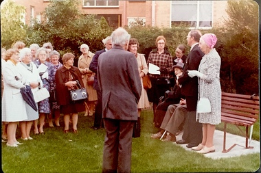
Photograph - Opening of the Dorothy Rogers Reserve, 1976
... ...public parks -- kew (vic.)...Three years after her death in 1973, the Reserve was opened in her honour. dorothy rogers reserve public parks -- kew (vic.) Inscribed verso: "Members and relatives of the late Dorothy Rogers. ...Dorothy Rogers wrote two major books on Kew's history: Lovely Old Homes of Kew (1961) and A History of Kew (1973). In addition to her published works, she was a regular contributor on issues of local history to suburban newspapers. Her archives are held in the collections of the State Library of Victoria and Kew Historical Society. Three years after her death in 1973, the Reserve was opened in her honour.Faded colour positive photograph of the opening of the Dorothy Rogers Reserve in 1976. The naming of the reserve honoured the contribution of the historian Dorothy Rogers, foundation member of the Society. The reserve is located on the north side of Studley Park Road just west of Kew Junction. Inscribed verso: "Members and relatives of the late Dorothy Rogers. Memorial reserve named and unveiled in her honour by (Cr Whiting Mayor) and City Manager Mr Fell 1978. In respect for her great research and service to the history of early Kew, and other places."dorothy rogers reserve, public parks -- kew (vic.) -
 Kew Historical Society Inc
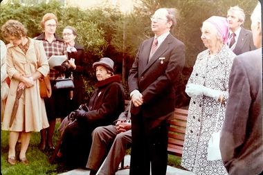
Photograph - Opening of the Dorothy Rogers Reserve, 1976
... ...public parks -- kew (vic.)...Three years after her death in 1973, the Reserve was opened in her honour. dorothy rogers reserve public parks -- kew (vic.) Inscribed verso: "Left to right: Mrs Rogers Jnr, Joy Stewart, Miss Jenkins sitting / Mrs Richardson and Mr Richardson, Brother of D. ...Dorothy Rogers wrote two major books on Kew's history: Lovely Old Homes of Kew (1961) and A History of Kew (1973). In addition to her published works, she was a regular contributor on issues of local history to suburban newspapers. Her archives are held in the collections of the State Library of Victoria and Kew Historical Society. Three years after her death in 1973, the Reserve was opened in her honour.Faded colour positive photograph of the opening of the Dorothy Rogers Reserve in 1976. The naming of the reserve honoured the contribution of the historian Dorothy Rogers, foundation member of the Society. The reserve is located on the north side of Studley Park Road just west of Kew Junction. Inscribed verso: "Left to right: Mrs Rogers Jnr, Joy Stewart, Miss Jenkins sitting / Mrs Richardson and Mr Richardson, Brother of D. Rogers), Mayor Cr Whiting, City Manager Mr Fell, Background / KHS President Miss Hall, Mr B O'Neill KHS member, / taken during the memorial unveiling of the Dorothy Rogers Reserve"dorothy rogers reserve, public parks -- kew (vic.) -
 Federation University Historical Collection
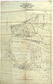
Plan, Ballaarat East Town Allotments, 1891, 18/09/1891
... The streets developed along gold leads and early tracks. The Public Park Botanic Gardens and Recreation Reserve is now Mount Xavier Golf Course, and Ballarat Secondary College Eastern Campus. ...It shows Victoria Street, Clifford Street, Finlay Street, Ryan Street, Bradbury Street, Elford Street, Fussell Street, Jones Street, Park Parade, Ballarat -Geelong Railway, Eureka Street, Ballarat East Public Park Botanic Garden and Recreation Reserve. ...The streets developed along gold leads and early tracks. The Public Park Botanic Gardens and Recreation Reserve is now Mount Xavier Golf Course, and Ballarat Secondary College Eastern Campus. ...Ballarat East was historically a separate municipality than Ballaarat. The streets developed along gold leads and early tracks. The Public Park Botanic Gardens and Recreation Reserve is now Mount Xavier Golf Course, and Ballarat Secondary College Eastern Campus. The section with Bettle's Private Property is now Saint Francis Xavier Primary School. Elford Street now appears to be the continuation of Eureka Street.Plan of Town Allotments for a portion of Ballarat East in the County of Grant. It shows Victoria Street, Clifford Street, Finlay Street, Ryan Street, Bradbury Street, Elford Street, Fussell Street, Jones Street, Park Parade, Ballarat -Geelong Railway, Eureka Street, Ballarat East Public Park Botanic Garden and Recreation Reserve. The only allotment names is Bettle's Private Property. Gift of the Squire Family, 2014ballarat east, ballaarat east, victoria street, ballarat east botanical gardens, richard squire, squire, ryan street, jones street, bradbury street, humffray steet, fussell street, elford street -
Whitehorse Historical Society Inc.
Article, Land safe, no houses, 2008
... Land at Lake Road Blackburn will become a public park belonging to Whitehorse Council and the Federal government after 30 December 2009....Land at Lake Road Blackburn will become a public park belonging to Whitehorse Council and the Federal government after 30 December 2009. ...Land at Lake Road Blackburn will become a public park belonging to Whitehorse Council and the Federal government after 30 December 2009.Land at Lake Road Blackburn will become a public park belonging to Whitehorse Council and the Federal government after 30 December 2009.Land at Lake Road Blackburn will become a public park belonging to Whitehorse Council and the Federal government after 30 December 2009.blackburn lake sanctuary, lake road blackburn, barresi, phil -
 Tennis Australia
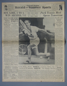
Newspaper, 28-Jun-36
... 28 June 1936 issue of the 'Chicago Herald and Examiner', featuring an article about veteran Gene Quinn's attempt to win the 3rd annual Chicago Public Parks Tournament. Materials: Ink, Paper...Tennis Australia Melbourne Park Olympic Boulevard Melbourne Park Melbourne melbourne Tennis 28 June 1936 issue of the 'Chicago Herald and Examiner', featuring an article about veteran Gene Quinn's attempt to win the 3rd annual Chicago Public Parks Tournament. Materials: Ink, Paper Newspaper ...28 June 1936 issue of the 'Chicago Herald and Examiner', featuring an article about veteran Gene Quinn's attempt to win the 3rd annual Chicago Public Parks Tournament. Materials: Ink, Papertennis -
 Coal Creek Community Park & Museum
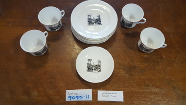
Tea set, 1932
... White chin tea set with a black printed transfer of Korumburra Public Park as the decoration on each item. 9090.1 - 9090.4 Four tea cups 9090.5 Saucer 9090.6 - 9090.11 Six side plates...On bottom of each SHEFFIELD MADE IN ENGLAND White chin tea set with a black printed transfer of Korumburra Public Park as the decoration on each item. 9090.1 - 9090.4 Four tea cups 9090.5 Saucer 9090.6 - 9090.11 Six side plates Tea set ...Presented to Olive Cassell in 1932 on the occasion of her marriage to Clive Jarvis, by her brother Leonard, son of local butcher Milton Cassell. The tea set was bought at O.Gilpins store in Korumburra . It was donated by Leonard Cassell on 22nd September 2011. White chin tea set with a black printed transfer of Korumburra Public Park as the decoration on each item. 9090.1 - 9090.4 Four tea cups 9090.5 Saucer 9090.6 - 9090.11 Six side platesOn bottom of each SHEFFIELD MADE IN ENGLAND -
 Bendigo Historical Society Inc.
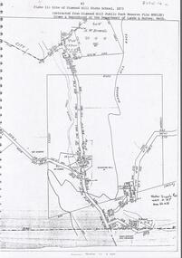
Document - DIAMOND HILL STATE SCHOOL SITE
... On top of page 'extracted from Diamond Hill Public Park Reserve File RS8128, drawn and reproduced at the Department of Lands and Survey, Melbourne'...On top of page 'extracted from Diamond Hill Public Park Reserve File RS8128, drawn and reproduced at the Department of Lands and Survey, Melbourne' Document DIAMOND HILL STATE SCHOOL SITE ...Map (copy) showing the site of Diamond Hill State School, 1873. On top of page 'extracted from Diamond Hill Public Park Reserve File RS8128, drawn and reproduced at the Department of Lands and Survey, Melbourne'bendigo, education, diamond hill state school -
 Phillip Island and District Historical Society Inc.
Photograph
... ...public camping park...Photograph of the old TeaTree Tea House in the public Camping Park, Church Street, Cowes. ...This is the current Cowes Foreshore Tourist Park. 2020 phillip island local history photography photographs the old ti-tree tea house black & white photograph tea house cowes public camping park john jenner bryant west Camping Photograph of the old TeaTree Tea House in the public Camping Park, Church Street, Cowes. ...One of a collection of over 400 photographs in an album commenced in 1960 and presented to the Phillip Island & Westernport Historical Society by the Shire of Phillip Island. This is the current Cowes Foreshore Tourist Park. 2020Photograph of the old TeaTree Tea House in the public Camping Park, Church Street, Cowes. phillip island, local history, photography, photographs, the old ti-tree tea house, black & white photograph, tea house, cowes, public camping park, john jenner, bryant west, camping -
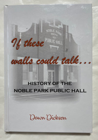 City of Moorabbin Historical Society (Operating the Box Cottage Museum)
Book, Dickson, Dawn, If these walls could talk : History of the Noble Park Public Hall
... If these walls could talk : History of the Noble Park Public Hall...Park...Dandenong...Public...The story and stories of Noble Park Public Hall....The story and stories of Noble Park Public Hall. If these walls could talk : History of the Noble Park Public Hall Book Dickson, Dawn ...The story and stories of Noble Park Public Hall.The story and stories of Noble Park Public Hall.non-fictionThe story and stories of Noble Park Public Hall.noble park, dandenong, public hall -
 Eltham District Historical Society Inc
Photograph, Public toilets, Were Street, Montmorency, c.1990
... public tiolets...were street...Parks...Brick paved footpath, angle parking and two public phone boxes. montmorency public tiolets were street Parks Public Toilets shopping centres 6 colour photographs (2 sets) Public toilets, Were Street, Montmorency Photograph Photograph ...Photographs of public land in Were Street, Montmorency with public toilets. Before the the erection of the wind mill. Brick paved footpath, angle parking and two public phone boxes.6 colour photographs (2 sets)montmorency, public tiolets, were street, parks, public toilets, shopping centres -
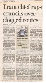 Melbourne Tram Museum
Newspaper, The Age, "Tram chief raps councils over clogged routes", 22/04/2007 12:00:00 AM
... ... Public Transport... Car Parks...Melbourne Tram Museum 8 Wallen Road Hawthorn melbourne Trams tramways Traffic Lights Congestion Public Transport Car Parks Newspaper clipping from The Age, 22/4/2007 titled "Tram chief raps councils over clogged routes "written by Stephen Cauchi. about issues with clearways. ...Newspaper clipping from The Age, 22/4/2007 titled "Tram chief raps councils over clogged routes "written by Stephen Cauchi. about issues with clearways. Quotes Dennis Cliche, Yarra Trams CEO, Jim Betts, Director of Public Transport, Dick Gross President of the MAV, Peter Daly RACV and Daniel Bower PTUA. Concerned with the length of journeys, Think Tram, traffic light priority.trams, tramways, traffic lights, congestion, public transport, car parks -
Lakes Entrance Historical Society
Album - Photograph Album, Lady Harrietts Barge relocation,Lakes Entrance Victoria, 1995
... Parks...Public Works...Lakes Entrance Historical Society 4 Marine Parade Lakes Entrance gippsland Environment Parks Public Works Small photograph album containing twenty three colour photographs showing relocation of Lady Harrietts Barge from Bullock Island to New Works precinct Lakes Entrance Victoria. ...Small photograph album containing twenty three colour photographs showing relocation of Lady Harrietts Barge from Bullock Island to New Works precinct Lakes Entrance Victoria. Includes two colour photographs of toilets and two colour photographs of old machinery on concrete pad at New Workds areaenvironment, parks, public works -
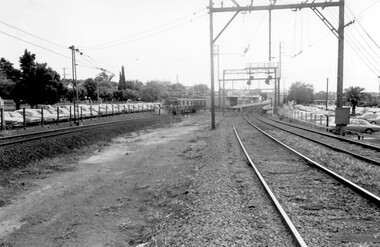 Surrey Hills Historical Society Collection
Photograph, Surrey Hills Station and car park
... parks...public transport...The palm tree had been planted in the station master's front garden and was retained in a small garden bed within the car park. 1971 surrey hills station railway stations car parks public transport trains railway lines palm tree A black and white photograph of a station with cars parked on both sides of the 3 tracks. ...There are 3 tracks; the third track was built in 1971, which gives an approximate date for the photo. At this time the original station buildings were demolished and replaced by buildings constructed from concrete bricks and a second subway replaced the overhead footbridge. According to Roderick Smith, a local railway enthusiast, originally there had been 3 railway houses at the Mont Albert end of the northern car park. These were demolished to extend the car park. Certainly 8 Bedford Avenue, built as the station master's house was demolished at this time. The palm tree had been planted in the station master's front garden and was retained in a small garden bed within the car park. A black and white photograph of a station with cars parked on both sides of the 3 tracks. A Harris train is departing the station heading towards Mont Albert. A palm tree is prominent in the station car park to the north.1971, surrey hills station, railway stations, car parks, public transport, trains, railway lines, palm tree -
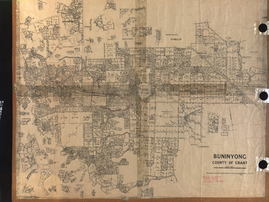 Federation University Historical Collection
Plan, Department of Crown Lands and Survey, Melbourne, Buninyong County of Grant, 23/07/1929
... A parish plan of Buninyong, including Robert Scott's Mt Buninyong Pre-emptive Right, Mt Buninyong Public Park, Thomas Learmonth's land, John Learmonth's land, Scotchan's, Yendon. ...Forrest Parkin Lee Buninyong Recreation Reserve A parish plan of Buninyong, including Robert Scott's Mt Buninyong Pre-emptive Right, Mt Buninyong Public Park, Thomas Learmonth's land, John Learmonth's land, Scotchan's, Yendon. ...The plan was photo-lithographed at the Departmen tof Lands and Survey, MelbourneA parish plan of Buninyong, including Robert Scott's Mt Buninyong Pre-emptive Right, Mt Buninyong Public Park, Thomas Learmonth's land, John Learmonth's land, Scotchan's, Yendon. The Buninyong POst Office is Allotment 1. Pisition of tracks in 1859 have been marked on the plan in red.buninyong, scotchman's, mt buninyong, robert scott, clarendon, lal lal creek, yendon, warrenheip, yarowee, enfield, thomas learmonth, john learmonth, archibald fisken, g. schloo, george innes, peter inglis, durham lead, j. fry, j. forrest, parkin lee, buninyong recreation reserve -
Phillip Island and District Historical Society Inc.
Photograph, 1993
... The gazebo stands on land set apart as a public park in 1991....The gazebo stands on land set apart as a public park in 1991. local history photography photographs slides film gazebo in phillip island cemetery coloured photograph phillip island cemetery edwin rayner major donor Photograph of gazebo in Phillip Island Cemetery Photograph Photograph ...The cemetery land was set aside in 1870 and surveyed in 1903. The gazebo stands on land set apart as a public park in 1991.Photograph of gazebo in Phillip Island Cemeterylocal history, photography, photographs, slides, film, gazebo in phillip island cemetery, coloured photograph, phillip island cemetery, edwin rayner, major donor -
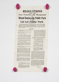 Buninyong & District Historical Society
Document - Printed Linen Notice, Regulations for the Care, Protection, and Management of Mount Buninyong Public Park and Lal Lal Public Park, 1936
... Regulations for the Care, Protection, and Management of Mount Buninyong Public Park and Lal Lal Public Park...The printed notice would have been posted publicly at the Mount Buninyong and Lal Lal parks to advertise the 1936 regulations for the care, protection and management of these public parks....Buninyong & District Historical Society Old Court House, Buninyong Town Hall 313 Learmonth Street Buninyong goldfields The printed notice would have been posted publicly at the Mount Buninyong and Lal Lal parks to advertise the 1936 regulations for the care, protection and management of these public parks. historical and social record of the types of regulations imposed on the public while in public places in 1936 Mount Buninyong Lal Lal park regulations Linen notice printed with ink, describing 1936 regulations of Mount Buninyong and Lal Lal parks Regulations for the Care, Protection, and Management of Mount Buninyong Public Park and Lal Lal Public Park Document Printed Linen Notice ...The printed notice would have been posted publicly at the Mount Buninyong and Lal Lal parks to advertise the 1936 regulations for the care, protection and management of these public parks.historical and social record of the types of regulations imposed on the public while in public places in 1936Linen notice printed with ink, describing 1936 regulations of Mount Buninyong and Lal Lal parksmount buninyong, lal lal, park, regulations -
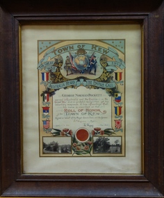 Kew Historical Society Inc
Certificate, Town of Kew, Roll of Honor of the Town of Kew : George Norman Pockett, 1918
... George Norman Pockett, who was awarded the certificate was the son of George Pockett , who with his brother designed a number of public parks in Melbourne. George Pockett Snr. was the first curator of the Alexandra Gardens in Kew. ...Kew Historical Society Inc Kew Court House 188 High Street Kew melbourne George Norman Pockett, who was awarded the certificate was the son of George Pockett , who with his brother designed a number of public parks in Melbourne. George Pockett Snr. was the first curator of the Alexandra Gardens in Kew. ...George Norman Pockett, who was awarded the certificate was the son of George Pockett , who with his brother designed a number of public parks in Melbourne. George Pockett Snr. was the first curator of the Alexandra Gardens in Kew. (see Comment below)Rolls of Honor were awarded to returned soldiers at the end of the First World War by many towns and cities. This framed certificate awarded to George Norman Pockett by the Town of Kew is one of two held in the Collection. The item is well-provenanced, and through the formal use of emblems and images in the design allows us to make judgements about social and cultural values in the period.Framed Illuminated Certificate: A commemorative certificate documenting the war service of George Norman Pockett of 18 Cobden Street, Kew. George Pockett enrolled at the age of 23 on 5 October 1915, as an engineer in the Australian Army. He embarked on HMAT Wiltshire A18 on 18 November 1915. His rank was that of Warrant Officer Armament Artificer in the 4 FAB [Field Artillery Brigade]. The website of the Australian War Memorial records that he was mentioned in dispatches. The formal certificate records that ‘George Norman Pockett served Australia and the Empire in the Great War and in grateful recognition of his voluntary response to his Country’s Call his name is inscribed on the Roll of Honor of the Town of Kew’. The then Mayor and Town Clerk signed the certificate. [Kew did not become a ‘City’ until 1921]. The certificate highlights emblems and symbols of Australia and Great Britain, and includes the coats of arms of the allies in the war. The certificate is customised with two black and white photographs of Kew: the rotunda in the Alexandra Gardens at left, and boating on the Yarra River at right.George Norman Pockett served Australia and the Empire in the Great War and in grateful recognition of his voluntary response to his Country's Call his name is recorded on the Roll of Honor Town of Kew on behalf of the Mayor, Councillors and Burgesses. 1.8.18. E.P. Wynne [Mayor] H. Harrison [Town Clerk]george norman pockett, first world war - memorabilia - certificates, town of kew (vic), kew war memorial - roll of honor, wwi -
 Kew Historical Society Inc
Photograph - Yarra Valley at Kew, 1918
... In the twentieth century, before and after the construction of the Eastern Freeway, much of this low-lying area was used as golf courses and public parks....In the twentieth century, before and after the construction of the Eastern Freeway, much of this low-lying area was used as golf courses and public parks. yarra river yarra valley Verso: "Willsmere / East Kew? ...During the nineteenth century, the land abutting the south side of the Yarra in Kew was devoted to dairy farming. In the twentieth century, before and after the construction of the Eastern Freeway, much of this low-lying area was used as golf courses and public parks.View of the farmland in the Yarra Valley at what is believed to be East Kew in 1918. Verso: "Willsmere / East Kew? / 1918"yarra river, yarra valley -
 Kew Historical Society Inc
Photograph - Yarra Valley at Kew, 1912
... In the twentieth century, before and after the construction of the Eastern Freeway, much of this low-lying area was used as golf courses and public parks....In the twentieth century, before and after the construction of the Eastern Freeway, much of this low-lying area was used as golf courses and public parks. yarra river yarra valley farming -- kew (vic.) ...During the nineteenth century, the land abutting the south side of the Yarra in Kew was devoted to dairy farming. In the twentieth century, before and after the construction of the Eastern Freeway, much of this low-lying area was used as golf courses and public parks.Real-photo postcard of the farmland in the Yarra Valley in what is believed to be North Kew in 1912. Verso: "Willsmere / East Kew / 1912"yarra river, yarra valley, farming -- kew (vic.) -
University of Melbourne, Burnley Campus Archives
Document - Report, Department of Conservation and National Parks and Public Land Division, Kooyoora State Park Proposed Management Plan, November 1991
... Provides detailed management aims and actions to protect the Park's natural and cultural values and to promote public enjoyment of the Park. ...Department of Conservation and National Parks and Public Land Division....Produced by the Department of Conservation and Environment, Victoria, Bendigo Region and National Parks and Public Land Division Kooyoora State Park Proposed Management Plan Document Report Department of Conservation and National Parks and Public Land Division. ...kooyoora state park, management plan, department of conservation & environment, bendigo region -
Glen Eira Historical Society
Document - Lempriere Avenue, 10, St. Kilda East
... Includes some information on the Lempriere Family and public park, Greenmeadows Gardens. The document by Rosalind Landells, David Bick and Hilary Bullock of the Brighton Historical Society is dated October 30, 1995. ...Includes some information on the Lempriere Family and public park, Greenmeadows Gardens. The document by Rosalind Landells, David Bick and Hilary Bullock of the Brighton Historical Society is dated October 30, 1995. ...A brief history of the property at 10 Lempriere Avenue, St. Kilda East, built on a subdivision of the land of William George Lempriere. Includes some information on the Lempriere Family and public park, Greenmeadows Gardens. The document by Rosalind Landells, David Bick and Hilary Bullock of the Brighton Historical Society is dated October 30, 1995. Includes handwritten notes covering mostly same information. Includes bibliography.greenmeadows, lempriere william george, clarke william senior, lempriere john thomson, zimmerman a.k., nelson frank l., greenmeadows gardens, lempriere avenue, nelson m.d., st. kilda east, parks and reserves, zucker a.a., greenmeadows lane, lempriere family, lempriere’s paddock, councillors -
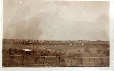
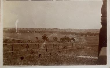
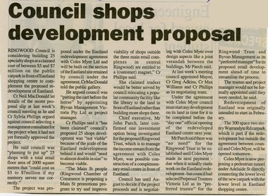 Ringwood and District Historical Society
Newspaper, Scrapbook Clipping, Library Collection, Ringwood, Victoria, `
... Ringwood Council is considering building 25 specialty shops at a claimed cost of between $5 and $7 million on the public car park in front of Eastland shopping centre to cpmplement the proposed redevelopment of Eastland....Ringwood and District Historical Society 125A Warrandyte Road Ringwood North melbourne ` ` ` Ringwood Council is considering building 25 specialty shops at a claimed cost of between $5 and $7 million on the public car park in front of Eastland shopping centre to cpmplement the proposed redevelopment of Eastland. ...``Newspaper clipping from "The Post", 24-3-93, P3. Council shops development proposal Ringwood Council is considering building 25 specialty shops at a claimed cost of between $5 and $7 million on the public car park in front of Eastland shopping centre to cpmplement the proposed redevelopment of Eastland.` -
 Greensborough Historical Society
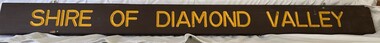
Sign, Shire of Diamond Valley, Shire of Diamond Valley: Park or Reserve sign, 1964-1994
... This sign would have been at the entry to one of the many public parks and reserves created during the time of the Shire of Diamond Valley (1964-1994). ...This sign would have been at the entry to one of the many public parks and reserves created during the time of the Shire of Diamond Valley (1964-1994). ...Shire of Diamond Valley timber sign. This sign would have been at the entry to one of the many public parks and reserves created during the time of the Shire of Diamond Valley (1964-1994). Following the redistribution of local government areas in 1994, the previous Shire of Diamond Valley was split between City of Banyule and Shire of Nillumbik. Signage would have been replaced to reflect the new 'owners' of the property. The exact location of this sign is unknown.Brown painted Timber sign with yellow writing etched into timbershire of diamond valley, sign, parks - greensborough -
!['Save Fairfield Hospital' badge, [1990s]](/media/collectors/5bb42dc221eaf31100db1d3b/items/5c9af03221ea720f88da88fb/item-media/5c9af03f21ea720f88daaa65/item-fit-380x285.jpg?cb=6) Australian Nursing & Midwifery Federation
Australian Nursing & Midwifery Federation'Save Fairfield Hospital' badge, [1990s]
... One section of the site was gazetted as a Public Park and Memorial Garden (containing an AIDS Garden)....One section of the site was gazetted as a Public Park and Memorial Garden (containing an AIDS Garden). medicine health public institutions fairfield victoria city of darebin melbourne politics political protest public protest campaigning badges buttons pins public health infectious diseases aids Circular white and red plastic badge. ...Fairfield Hospital opened in 1904 as the Queen's Memorial Infectious Diseases Hospital, the first purpose-built isolation hospital for infectious diseases in Victoria. Its 22-acre site was located on a bank of the Yarra River. It was renamed Fairfield Hospital in 1948. In its later years, the hospital was a centre for AIDS treatment in Victoria, and a passionate campaign fought against its planned closure in the 1990s. Fairfield Hospital finally closed in June 1996. One section of the site was gazetted as a Public Park and Memorial Garden (containing an AIDS Garden).Circular white and red plastic badge. Silver metal, plastic-coated, with safety pin fastener adhered to back. Badge printed with the red text 'SAVE FAIRFIELD HOSPITAL'. Silver metal, plastic-coated, with safety pin fastener adhered to back.medicine, health, public institutions, fairfield, victoria, city of darebin, melbourne, politics, political protest, public protest, campaigning, badges, buttons, pins, public health, infectious diseases, aids -
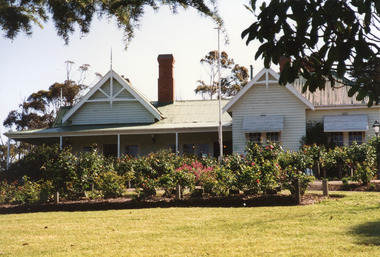 Lakes Entrance Historical Society
Photograph - Nyerimilang Homestead Kalimna West 1999
... Nyerimilang Homestead is in public ownership, managed by Parks Victoria....Nyerimilang Homestead is in public ownership, managed by Parks Victoria. Historic Buildings Local History Colour photograph of Nyerimilang Homestead showing front view, including rose garden. ...Nyerimilang Homestead is in public ownership, managed by Parks Victoria.Colour photograph of Nyerimilang Homestead showing front view, including rose garden. Situated off Kalimna West Road, Nungurner, it is a large white painted timber homestead, corrugated iron roof of hips and gables, painted green, five internal brick chimneys. Situated above the lake with views of Fraser Island and Flannagan Island, outer barrier and distant ocean. Nungurner Victoriahistoric buildings, local history -
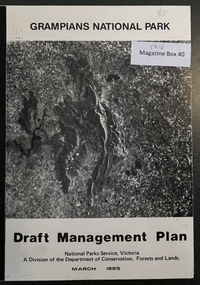 Stawell Historical Society Inc
Book - Report, Grampians National Park Draft Management Plan, 1985
... For Public comment to National Park Service, Victoria. A Division of the department of Conservation, Forest and Lands...For Public comment to National Park Service, Victoria. A Division of the department of Conservation, Forest and Lands $5 Barry Clugston Soft Cover with B/W Photo of aerial view of ranges of Grampians. ...For Public comment to National Park Service, Victoria. A Division of the department of Conservation, Forest and LandsSoft Cover with B/W Photo of aerial view of ranges of Grampians. Black taped Spine binding.$5 Barry Clugston