
Showing 18 items matching "railway map 1887"
-
 Bendigo Historical Society Inc.
Photograph - RAILWAY PHOTOGRAPHS
... ...Railway map 1887...Railway Photographs Disc 1 1887 Railways Map - Disc 2...Railway Photographs Railway map 1887 DVD. Railway Photographs Disc 1 1887 Railways Map - Disc 2 Photograph RAILWAY PHOTOGRAPHS ...DVD. Railway Photographs Disc 1 1887 Railways Map - Disc 2railway photographs, railway map 1887 -
 Federation University Historical Collection
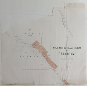
Plan, Goldmining Lease Blocks at Darkbonne, c1887
... This map was originally inserteed into the Reports of Mining Registrars for the Quarter ender 30th June 1887. darkbonne st arnaud new bendigo mine alpha mine working miners mine chinese camp donald/st arnaud railway Saint Arnaud Darkbonne State School Paper plan showing Goldmining Lease Blocks at Darkbonne, north west of and near St Arnaud, on the Sunraysia Highway. ...This map was originally inserteed into the Reports of Mining Registrars for the Quarter ender 30th June 1887.Paper plan showing Goldmining Lease Blocks at Darkbonne, north west of and near St Arnaud, on the Sunraysia Highway. darkbonne, st arnaud, new bendigo mine, alpha mine, working miners mine, chinese camp, donald/st arnaud railway, saint arnaud, darkbonne state school -
 Ringwood and District Historical Society
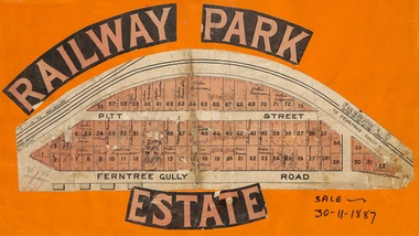
Flyer, Subdivision sale poster - Railway Park Estate, Ringwood, Victoria - 1887
... Collage of clipped lettering and map pasted to orange coloured card depicting Railway Park Estate subdivision sale. Handwritten names associated with allotments and notation of sale date - 30 November, 1887. ...Collage of clipped lettering and map pasted to orange coloured card depicting Railway Park Estate subdivision sale. Handwritten names associated with allotments and notation of sale date - 30 November, 1887. ...Collage of clipped lettering and map pasted to orange coloured card depicting Railway Park Estate subdivision sale. Handwritten names associated with allotments and notation of sale date - 30 November, 1887. Subdivision plan with pink shading highlighting 73 allotments in Ferntree Gully Road (later Bedford Road) and Pitt Street, Ringwood. Handwritten names associated with allotments include Arthur Wiseman, T. Grant, J.J. Miller, M. Dickson, G.G. Miller, J. Frost, J.K. Turnbul, J.W. Davis, William Aldridge. Additional hand-drawn map on cardboard backing labeled Allotments for Sale at Ringwood - Part of Crown Allotment 17. -
 Ringwood and District Historical Society
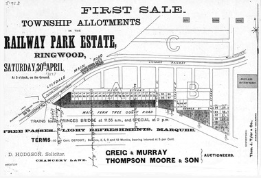
Flyer, Subdivision advertisement - Railway Park Estate, Ringwood, Victoria - circa 1887
... Photocopy of advertisement for auction sale of township allotments in Railway Park Estate, Ringwood, on Saturday 30th April (1887?), with terms of sale and location map....map includes Pitt Street and Main Ferntree Gully Road (later Bedford Road). (Agents) Greig & Murray, Thompson Moore & Son, Auctioneers. Photocopy of advertisement for auction sale of township allotments in Railway Park Estate, Ringwood, on Saturday 30th April (1887?) ...Photocopy of advertisement for auction sale of township allotments in Railway Park Estate, Ringwood, on Saturday 30th April (1887?), with terms of sale and location map.Subdivision map includes Pitt Street and Main Ferntree Gully Road (later Bedford Road). (Agents) Greig & Murray, Thompson Moore & Son, Auctioneers. -
 Ringwood and District Historical Society
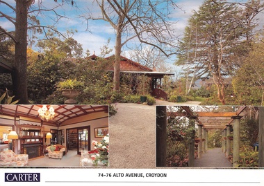
Document, Real Estate History of "Shadowood", 74-76 Alto Avenue, Croydon, Victoria
... Map of Wicklow Hills subdivision, including Alto Avenue, Elesmere Avenue, Glenora Avenue, Wicklow Avenue, and railway line to Lilydale. Title Vol 1323 Fol 264412 Allotment 43C Parish of Warrandyte - Ann McKean, dated 6th October, 1881. Title Vol 1937 Fol 387367 Part of Allotment 43C Parish of Warrandyte - Richard Bonynge Kelly, 11th August, 1887...Map of Wicklow Hills subdivision, including Alto Avenue, Elesmere Avenue, Glenora Avenue, Wicklow Avenue, and railway line to Lilydale. Title Vol 1323 Fol 264412 Allotment 43C Parish of Warrandyte - Ann McKean, dated 6th October, 1881. Title Vol 1937 Fol 387367 Part of Allotment 43C Parish of Warrandyte - Richard Bonynge Kelly, 11th August, 1887 ...Folder of Estate Agent's notes compiled in preparation for property auction, 11th October, 2008. Two-page history of "Shadowood", display photo of house with floor plan dating from circa 1920s, copies of LANDATA title documents. Map of Wicklow Hills subdivision, including Alto Avenue, Elesmere Avenue, Glenora Avenue, Wicklow Avenue, and railway line to Lilydale. Title Vol 1323 Fol 264412 Allotment 43C Parish of Warrandyte - Ann McKean, dated 6th October, 1881. Title Vol 1937 Fol 387367 Part of Allotment 43C Parish of Warrandyte - Richard Bonynge Kelly, 11th August, 1887. Title Vol 2728 Fol 543569 Part of Allotment 43C Parish of Warrandyte - Thomas Robertson, 27th July, 1898. Title Vol 4161 Fol 832181 Part of Allotment 43C Parish of Warrandyte - John Gordon Robertson, 4th November, 1918. Title Vol 4490 Fol 897808 Lots 82 and 83, Plan of Subdivision 7478 - Elizabeth Rutherford Morell, 12th August, 1921. Title Vol 4617 Fol 923322 Lot 82, Plan of Subdivision 7478 - Flora Clapperton, 23rd September, 1922. Title Vol 8409 Fol 533, part of Lot 82, Plan of Subdivision 7478 - Hugh Ravenscroft Hastings Wettenhall and Sybella Anne Wettenhall, 1st May, 1962. -
 Bendigo Historical Society Inc.
Map - RAILWAY POSTAL & TELEGRAPH MAP OF VICTORIA, 1887
... Railway Postal & Telegraph Map of Victoria 1887 printed on canvas in a fold out book form with name printed on back F.L.Outtrim, in a cardboard cover with red and blue pattern....MAP Victoria railway Picturesque Atlas Publishing Co Ltd Sydney & Melbourne Railway Postal & Telegraph Map of Victoria 1887 printed on canvas in a fold out book form with name printed on back F.L.Outtrim, in a cardboard cover with red and blue pattern. ...Railway Postal & Telegraph Map of Victoria 1887 printed on canvas in a fold out book form with name printed on back F.L.Outtrim, in a cardboard cover with red and blue pattern.Picturesque Atlas Publishing Co Ltd Sydney & Melbournemap, victoria, railway -
 Bendigo Historical Society Inc.
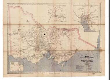
Map - RAILWAYS COLLECTION: PHOTO OF RAILWAY POSTAL & TELEGRAPH MAP OF VICTORIA 1887, 1887
... RAILWAYS COLLECTION: PHOTO OF RAILWAY POSTAL & TELEGRAPH MAP OF VICTORIA 1887...Railway Postal & Telegraph Map of Victoria 1887-...RAILWAYS COLLECTION- photo of Railway Postal & Telegraph Map of Victoria 1887- aged map showing the various Country Lines and insets show Melbourne and vicinity, Ballarat and vicinity and Geelong and vicinity....PHOTOGRAPH Railway Postal & Telegraph Map of Victoria 1887- Picturesque Atlas Publishing Company RAILWAYS COLLECTION- photo of Railway Postal & Telegraph Map of Victoria 1887- aged map showing the various Country Lines and insets show Melbourne and vicinity, Ballarat and vicinity and Geelong and vicinity. ...RAILWAYS COLLECTION- photo of Railway Postal & Telegraph Map of Victoria 1887- aged map showing the various Country Lines and insets show Melbourne and vicinity, Ballarat and vicinity and Geelong and vicinity.Picturesque Atlas Publishing Companyphotograph, railway postal & telegraph map of victoria 1887- -
 Bendigo Historical Society Inc.
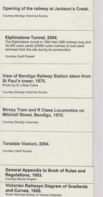
Document - BADHAM COLLECTION: EXHIBITION LABELS X 15 - CARDBOARDS
... Exhibition labels x 15 - cardboards Railway Post Office stamps, 1865, and book 1951 - Courtesy Edna Westhead. Copy of 1887 Map of Railway Post Offices - Courtesy Edna Westhead Taken in 1921, Bendigo railway men celebrating 50 years since first train arrived in Bendigo in 1862 - Courtesy Bendigo Historical Society Book of Signals, 1949 - Courtesy Bernie Kingdon Book of Instruction Rolling Stock 1921, 1943 - Courtesy Bernie Kingdon Lost Property Book, 1886 - Courtesy Ross Rowley View of Bendigo Railway Station taken from St. ...DOCUMENT Memo railway Exhibition labels x 15 - cardboards Railway Post Office stamps, 1865, and book 1951 - Courtesy Edna Westhead. Copy of 1887 Map of Railway Post Offices - Courtesy Edna Westhead Taken in 1921, Bendigo railway men celebrating 50 years since first train arrived in Bendigo in 1862 - Courtesy Bendigo Historical Society Book of Signals, 1949 - Courtesy Bernie Kingdon Book of Instruction Rolling Stock 1921, 1943 - Courtesy Bernie Kingdon Lost Property Book, 1886 - Courtesy Ross Rowley View of Bendigo Railway Station taken from St. ...Exhibition labels x 15 - cardboards Railway Post Office stamps, 1865, and book 1951 - Courtesy Edna Westhead. Copy of 1887 Map of Railway Post Offices - Courtesy Edna Westhead Taken in 1921, Bendigo railway men celebrating 50 years since first train arrived in Bendigo in 1862 - Courtesy Bendigo Historical Society Book of Signals, 1949 - Courtesy Bernie Kingdon Book of Instruction Rolling Stock 1921, 1943 - Courtesy Bernie Kingdon Lost Property Book, 1886 - Courtesy Ross Rowley View of Bendigo Railway Station taken from St. Paul's tower, 1875 - Courtesy Bendigo Historical Society...document, memo, railway -
 Glen Eira Historical Society
Letter - Rosstown Railway
... RAILWAY COMPANY LIMITED, covering dates between 1887 and 1894. The notes concern meetings and creditors claims relevant to the companies, with reference numbers for the information source. Date and author of the notes are not recorded. 3/A black and white photocopy of the a partial map...RAILWAY COMPANY LIMITED, covering dates between 1887 and 1894. The notes concern meetings and creditors claims relevant to the companies, with reference numbers for the information source. Date and author of the notes are not recorded. 3/A black and white photocopy of the a partial map ...This file contains four items: 1/A black and white photocopy of a letter dated either 07/08/1889 or 09/08/1889, from Robert Lundon to an unidentified recipient discussing an agreement reached between the author – on behalf of the recipient – and Soon Hang Hi in regard, in regards to the allotment known as Webber’s. The agreement is outlined in the letter in what appears to be Chinese characters, and includes the marks of Robert Lundon and Soon Hang Hi. File note from Joy Wu states that the calligraphy is not Mandarin or traditional Chinese. 2/Three sheets of hand-written working notes with information taken from the Victorian Government Gazette on THE ROSSTOWN AND MURRUMBEENA LAND COMPANY LIMITED, THE ROSSTOWN JUNCTION RAILWAY AND PROSPERITY COMPANY LIOMITED, and THE ROSSTOWN JUNCTION, ELSTERNWICK, AND OAKLEIGH RAILWAY COMPANY LIMITED, covering dates between 1887 and 1894. The notes concern meetings and creditors claims relevant to the companies, with reference numbers for the information source. Date and author of the notes are not recorded. 3/A black and white photocopy of the a partial map of the Rosstown Railway and surrounding area, undated. The map includes the names of landholders in the areas of Brighton, Garden Vale and Elsternwick, as well as other railway lines present in the region. 4/A fold-out map and guide of the Rosstown Rail Trail, including a brief general history of Caulfield as well as a more extensive biography of William Murray Ross and the Rosstown Railway. The map marks and describes significant sites along the trail, including photographs of some of these sites, provided by DF Jowett.documents, correspondence, webber’s, lundon robert, chinese characters, ethnic communities, signatures, text, settlements, taxes, fraser john grieves, lovell r.h., price davies, meetings, communication activities, soon hang hi, commercial events and activities, the rosstown and murrumbeena land company limited, victorian government gazette, bulmer richard, parry john, osment henry, shareholders, creditors claims, the rosstown junction railway and property company limited, finch and best, lawyers, the rosstown junction elsternwick and oakleigh railway company limited, cameron w.c., phillips p.d., garden vale, elsternwick, elsternwick railway station, rosstown, rosstown railway, thomas street, bay street, kooyong road, melbourne and brighton railway, hawthorn road, bambra road, caulfield and frankston railway, booran road, grange road, koornang road, murrumbeena road, north road, north road railway station, east brighton railway station, south road, railway routes, railway lines, railways, land transport, murphy j., caulfield, hamilton t.f., dane p., holloway, webb, ailee john, payne t.b., brodie chas, dane john, o’neil h., mccombie john, mcmillane a., smyth c.d., cooper, ebden, landholders, jeffrey j.d., gill j., balcombe a.e., cooper h., mcnab j., white j., sutherland j., greeves a.f.a., newton m.c., chamley f.b., fowler j., inglis p., grant t., stooke j., swanson g., cochrane c., adams e.b., mccombie thas, keyes robert, brighton cemetery, burials grounds and graveyards, war-ein road, were j.b., holland j., mcmahon c., winter t.l.m., dendy henry, mitchell w., jackson s., were j.e., wickham francis dawe, bryant jane, east brighton railway station, railway stations, maps, allotments, land titles, roads and streets, rosstown rail trail, city of glen eira, tourism, trains, tourism information bureaus, tours, pamphlets, elsternwick railway park, oakleigh junction, princes park, ee gunn reserve, packer park, sites, jowett d.f., weickhardt i.g., return to rosstown: railways land sales and sugar beet ventures in caulfield, land sales, walking trails, ross william murray, transport objects, locomotion, walking, cycling, driving, sports, country mansions, people, caulfield john, builders, construction and demolition workers, occupations, careers, professionals, topography, geology, landforms, horticulture, market gardens, primary industry workers, city of caulfield, mood kee, pennington harold, annual general meetings, caulfield town hall, glen eira city council, carnegie, carnegie station, rosstown station, people by circumstance, migrants, sugar beet, sugar beet mill, sugar beet industry, mills, factories, sea beach lines, bent thomas, parliamentary representatives, neville street, miller street, lemann’s swamp reserve, koornang park, cane sugar industry, breweries, rabbit processing plants, health establishments, hospitals, food production establishments, abattoirs, thieves, social problems, vagrants, theft, squatting, financial economics, debt, finance industry, insurance companies, company managers, bentleigh, ross leila, the grange, leila road, wild cherry road, financial trouble, mortgages, gisborne street, archibald street, riddell parade, victoria railways, glen huntly road, clarence street, college street, gladstone parade, parrell street, aileen avenue, seaview street, land subdivisions, dover street, sussex street, landfill, marara road, booran road, woodville avenue, dorothy avenue, ormond park, royal avenue, ormond railway station, oakleigh road, melten avenue, miller street, munro avenue, lord reserve, neerim road, toolambool road, the rosstown hotel, rosanna street, murrumbeena crescent, commercial establishments, the national bank, rosstown road, kangaroo road, poath road, freda street, hughesdale kindergarten, oakleigh council, hughesdale community centre, civic establishments, galbally reserve, plaques, warrigal road, out and about brochures, orion estate -
 Warrnambool and District Historical Society Inc.
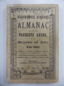
Book, Warrnambool Standard Almanac 1887, 1887
... map of the railway routes in Victoria. The cover is buff-coloured with black lettering and is slightly frayed. There is some scribble on the first page and the back cover. There are many black and white illustrations and several sketches of Warrnambool and district printed in pink. The name ‘Barber’ is handwritten in black ink on the front cover. Warrnambool Standard Almanac 1887 ...This booklet was given to subscribers to the Warrnambool Standard newspaper as an almanac for the year 1887. These Standard almanacs were produced from 1875 to 1930. They contain much local information on Warrnambool and district about the businesses, government officials, schools, societies and organizations, harbour management, churches, banks etc. The Warrnambool Standard newspaper was established in 1872 and continues to this day. This booklet is of high significance as it contains much valuable information on Warrnambool and district for the year 1887. It is a very important research tool for those studying and writing the history of Warrnambool and district. This copy has the name ‘Barber’ on the front cover and probably refers to George Barber, the son of George Barber, a well-known solicitor who opened a legal practice in Warrnambool in 1855. He died in 1879 and it appears that a member or members of his family went to live in the Maryborough district. This copy came into the collection of the Warrnambool and District Historical Society via the Midlands Historical Society.This is a soft cover booklet of 73 pages, plus several pages of advertisements. The section on the tourist’s guide to Warrnambool is printed in pink. There is a fold-out page with a map of the railway routes in Victoria. The cover is buff-coloured with black lettering and is slightly frayed. There is some scribble on the first page and the back cover. There are many black and white illustrations and several sketches of Warrnambool and district printed in pink. The name ‘Barber’ is handwritten in black ink on the front cover. ‘Barber’ ‘Miss Duff c/o Mrs Hyslop Farquar Lodge Lysle Street Ladysmith South Africa’warrnambool standard newspaper, history of warrnambool, standard almanac1887 -
 Sunshine and District Historical Society Incorporated
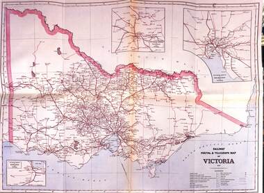
Map - 1887 Map of Railways and Telegraph Lines, 2004
... Railway Brochure Making Tracks celebrating 150 years of the Victorian Railways 12 September 2004 Map 1887 Map of Railways and Telegraph Lines ...railway -
 Ballarat Tramway Museum
Magazine, Australian Railway and Locomotive Historical Society, "ARLHS Bulletin", 1942
... Railway and Locomotive Historical Society Bulletins for the period May 1942 to December 1942. Each page has been stencil duplicated. Index sheets for the journals at the front of the documents. The sheets have been placed in a heavy brown flysheet and then placed in "The Riven" spring back binder. May 1942 - page 57 to 59 - has a article, Horse Trams of Ballarat 1887 to 1913" written by Wal Jack, including a map...Railway and Locomotive Historical Society Bulletins for the period May 1942 to December 1942. Each page has been stencil duplicated. Index sheets for the journals at the front of the documents. The sheets have been placed in a heavy brown flysheet and then placed in "The Riven" spring back binder. May 1942 - page 57 to 59 - has a article, Horse Trams of Ballarat 1887 to 1913" written by Wal Jack, including a map ...Yields information about the tramways of Ballarat and the North Melbourne tramways and has a strong association with well known tramway enthusiasts of the era., Yields information about the tramways of Ballarat and the North Melbourne tramways and has a strong association with well known tramway enthusiasts of the era.Set of 8 Australian Railway and Locomotive Historical Society Bulletins for the period May 1942 to December 1942. Each page has been stencil duplicated. Index sheets for the journals at the front of the documents. The sheets have been placed in a heavy brown flysheet and then placed in "The Riven" spring back binder. May 1942 - page 57 to 59 - has a article, Horse Trams of Ballarat 1887 to 1913" written by Wal Jack, including a map prepared by C. C. Singleton. June 1942 - page 82 & 83 - has an article "Electric Trams of Ballarat 1905 to 1942" written by Wal Jack. November 1942 - page 65 & 66, has an article "Flemington Bridge Tramways, The North Melbourne Electric Tramway and Lighting Company" written by Peter W Duckett.ballarat, esco, nmetl, melbourne, horse trams, electrification -
 Kew Historical Society Inc
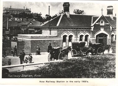
Print, Kew Railway Station in the early 1900s
... 1887 after a prolonged campaign for a railway by the people of Kew. Due to a decline in patronage, the passenger service ceased operations in August 1952. While a freight service continued for another five years, the line and station were officially closed on 13 May 1957. Subsequently demolished in 1959, the headquarters of VicRoads (formerly Country Roads Board) now stands on the former Station site. This work forms part of the collection assembled by the historian Dorothy Rogers, that was donated to the Kew Historical Society by her son John Rogers in 2015. The manuscripts, photographs, maps ...Kew Railway Station (1887-1959). ‘Kew Railway Station’ in Denmark Street was the terminus of the Kew Line, which extended from Hawthorn Station to just south of Wellington Street. The Station opened on 19 December 1887 after a prolonged campaign for a railway by the people of Kew. Due to a decline in patronage, the passenger service ceased operations in August 1952. While a freight service continued for another five years, the line and station were officially closed on 13 May 1957. Subsequently demolished in 1959, the headquarters of VicRoads (formerly Country Roads Board) now stands on the former Station site.This work forms part of the collection assembled by the historian Dorothy Rogers, that was donated to the Kew Historical Society by her son John Rogers in 2015. The manuscripts, photographs, maps, and documents were sourced by her from both family and local collections or produced as references for her print publications. Many were directly used by Rogers in writing ‘Lovely Old Homes of Kew’ (1961) and 'A History of Kew' (1973), or the numerous articles on local history that she produced for suburban newspapers. Most of the photographs in the collection include detailed annotations in her hand. The Rogers Collection provides a comprehensive insight into the working habits of a historian in the 1960s and 1970s. Together it forms the largest privately-donated collection within the archives of the Kew Historical Society.A photographic copy of a book plate from 'Kew's Civic Century' (1960) by W.D. Vaughan. The book plate was itself a copy of an early 20th century postcard depicting the Kew Railway Station."Railway opened 1887 - Then as photo states"kew railway station, dorothy rogers, country roads board, vicroads -
![Map, Ballarat and Gordons Lane Plan of Land required [for railway line work]](/media/collectors/5e461d8021ea67224c82f2a1/items/676ff3a62c3783fe00b96a8d/item-media/676ff4a42c3783fe00b96cb6/item-fit-380x285.jpg?cb=6) Bacchus Marsh & District Historical Society
Bacchus Marsh & District Historical SocietyMap, Ballarat and Gordons Lane Plan of Land required [for railway line work]
... The railway line from Melbourne to Bacchus Marsh was completed in February 1887. After this date work continued to extend the line to Ballan. This map...The railway line from Melbourne to Bacchus Marsh was completed in February 1887. After this date work continued to extend the line to Ballan. This map ...The railway line from Melbourne to Bacchus Marsh was completed in February 1887. After this date work continued to extend the line to Ballan. This map indicates a portion of land only a few hundred metres west of the Bacchus Marsh railway station which would have been among the first stages of the line to Ballan to have been constructed. This suggests the date of this map to be in the late 1880s.Single page map showing land required for railway line work near Griffith Street, Bacchus Marsh. Scale 10 chains to 1 inch. Hand-written on the map are the exact distances between Bacchus Marsh and Gordons (Gordon) and between Bacchus Marsh and Melbourne as measured from the corner of Maddingley Road and Station Street. Distances recorded are in miles, chains and links. The land required for the railway works is marked in red ink and runs through an area known as Kennedy's Gully. Part of a set of maps which are pasted into a bound volume containing 76 maps or plans in total. High resolution digital image stored on BMDHS computer network. bacchus marsh victoria history, maddingley victoria history, railway lines -
 Bacchus Marsh & District Historical Society
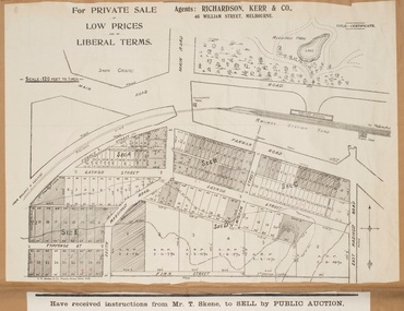
Map, Gaynor Street Land Sales, Maddingley, circa 1880s-1890s
... Features present on the map such as the Bacchus Marsh Railway Station indicate the land sale must have taken place some time after 1887 when the Railway Station opened. ...Features present on the map such as the Bacchus Marsh Railway Station indicate the land sale must have taken place some time after 1887 when the Railway Station opened. ...This map was produced for a major sale of land in the Maddingley area of Bacchus Marsh. The precise date of the sale has not been determined. Features present on the map such as the Bacchus Marsh Railway Station indicate the land sale must have taken place some time after 1887 when the Railway Station opened. A single page paper map showing land allotments for sale in the Maddingley area of Bacchus Marsh. Locations shown include Gaynor Street, Maddingley Road South, Parwan Road, Mitchem Street, Typpynge Street, Finn Street and East Maddingley Road. . The map is pasted into a bound volume containing 76 maps or plans in total. High resolution digital image stored on BMDHS computer network. bacchus marsh victoria maps, maddingley victoria maps, land use, maddingley victoria history, land sales bacchus marsh, land sales maddingley -
 Bacchus Marsh & District Historical Society
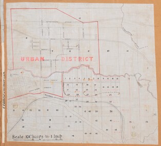
Map, Bacchus Marsh Urban District
... The date of this map has not been established but the date would be sometime after 1887 as the Bacchus Marsh Railway Station, which opened in 1887, is shown on the map. ...The date of this map has not been established but the date would be sometime after 1887 as the Bacchus Marsh Railway Station, which opened in 1887, is shown on the map. ...The date of this map has not been established but the date would be sometime after 1887 as the Bacchus Marsh Railway Station, which opened in 1887, is shown on the map. A single page paper map showing blocks of land in the urban district of Bacchus Marsh. The 'urban district' is indicated by red drawn lines on the map and includes streets and blocks on the northern side of the Werribee River in Bacchus Marsh, and streets and blocks south of the Werribee in Maddingley. Scale 10 chains to 1 inch. The map is pasted into a bound volume containing 76 maps or plans in total. High resolution digital image stored on BMDHS computer network. bacchus marsh victoria maps, maddingley victoria maps -
 Victorian Railway History Library
Book, St Albans Railway Centenary Committee, St Albans The First Hundred Years 1887-1987, 1987
... St Albans - railway - history Railroad construction - Victoria - history A history of the first hundred years of the St Albans railway station on the Bendigo line in Melbourne. index, ill, maps, p.74. St Albans The First Hundred Years 1887-1987 Book St Albans Railway Centenary Committee ...A history of the first hundred years of the St Albans railway station on the Bendigo line in Melbourne.index, ill, maps, p.74.non-fictionA history of the first hundred years of the St Albans railway station on the Bendigo line in Melbourne.st albans - railway - history, railroad construction - victoria - history -
 Victorian Railway History Library
Book, Light Railway Research Society of Australia, Tramways Down the Gorge: The story of Hillgrove, 1887-1921, 1986
... maps, p.35. Tramways Down the Gorge: The story of Hillgrove, 1887-1921 Book Light Railway Research Society of Australia Mainwaring, Ross ...A history of the narrow gauge tramways serving the Hillgrove mining district near Armidale in New South Wales.ill, maps, p.35.non-fictionA history of the narrow gauge tramways serving the Hillgrove mining district near Armidale in New South Wales.tramways - new south wales, mining tramways - australia - history
