Showing 108 items matching "railway tunnel"
-
 Bendigo Historical Society Inc.
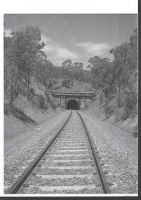
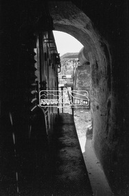
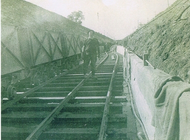
Photograph - RAILWAYS COLLECTION: RAILWAY TUNNEL SINGLE LINE
... RAILWAYS COLLECTION: RAILWAY TUNNEL SINGLE LINE...RAILWAYS COLLECTION -black and white Photo of the entrance to a Railway Tunnel (appears to be the Big Hill Tunnel) single line -writing on the back states -North Side....Photograph RAILWAYS COLLECTION: RAILWAY TUNNEL SINGLE LINE ...RAILWAYS COLLECTION -black and white Photo of the entrance to a Railway Tunnel (appears to be the Big Hill Tunnel) single line -writing on the back states -North Side.photograph, landscape -
 Bendigo Historical Society Inc.
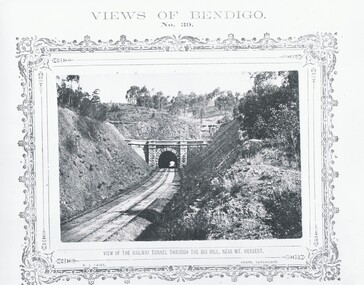
Photograph - VIEWS OF BENDIGO, VIEW OF RAILWAY TUNNEL THROUGH THE BIG HILL, 1875 Copy,1970
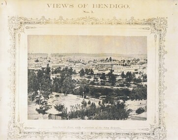
... VIEWS OF BENDIGO, VIEW OF RAILWAY TUNNEL THROUGH THE BIG HILL...Sepia photo on a cram board. Shows a railway tunnel through Big Hill near Mt. Herbert. ...'MP 157' N.J.Caire Sepia photo on a cram board. Shows a railway tunnel through Big Hill near Mt. Herbert. ...Sepia photo on a cram board. Shows a railway tunnel through Big Hill near Mt. Herbert. Inscription: Above, 'Views of Bendigo|No.39.'. Below, 'View of the Railway Tunnel through the Big Hill near Mt. Herbert', 'N.J.Caire Photo, Sandhurst'. Bottom, 'Casey & Wenborn's Print Forbes & Holmes, Agents',' The length of the Tunnel is about half-a-mile through the hill'. (two copies) Nicholas CaireN.J.Caireplace, bendigo, tunnel through big hill, see: 'views of bendigo' by n .j .caire. 'mp 157' -
 Eltham District Historical Society Inc
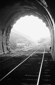
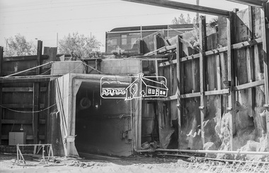
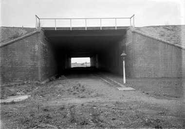
Photograph, Looking south from Big Hill railway tunnel near Bendigo, c.Oct. 1962
... Looking south from Big Hill railway tunnel near Bendigo......Railway Tunnel...Eltham District Historical Society Inc 728 Main Rd Eltham melbourne Bendigo Big Hill George Coop Collection Railway Tunnel Digital TIFF file Scan of 35mm Ilford FP3 black and white negative transparency Looking south from Big Hill railway tunnel near Bendigo Photograph Photograph George Coop George Coop ...Digital TIFF file Scan of 35mm Ilford FP3 black and white negative transparencybendigo, big hill, george coop collection, railway tunnel -
![View of the railway tunnel through the big hill near Mount Herbert / [by] Nicholas Caire, circa 1876](/media/collectors/550653872162f11fb04854aa/items/57774c0fd0cdd10a5c13912e/item-media/57774c7dd0cdd10a5c13c1ab/item-fit-380x285.jpg?cb=6) Kew Historical Society Inc
Kew Historical Society IncPhotograph, Anglo-Australasian Photographic Company, View of the railway tunnel through the big hill near Mount Herbert, c. 1876
... View of the railway tunnel through the big hill near Mount Herbert....: VIEW OF THE RAILWAY TUNNEL THROUGH THE BIG HILL NEAR MOUNT HERBERT. / COPYRIGHT REGISTERED. printed in ink on support reverse c.: VIEWS OF VICTORIA. / (GENERAL SERIES.) / No. 10. / VIEW OF THE RAILWAY TUNNEL THROUGH THE BIG HILL NEAR MOUNT HERBERT. / This tunnel is situated on the Mount Alexander and Murray Railway Line, between Castlemaine and Sandhurst, / and is 431 yards long; the completion of this and the remaining portion of the line to Bendigo was celebrated by / great public feasting. ...Albumen silver photograph on board View of the railway tunnel through the big hill near Mount Herbert Photograph Photograph Anglo-Australasian Photographic Company ...Nicholas Caire was born on Guernsey in the Channel Islands in 1837. He arrived in Adelaide with his parents in about 1860. In 1867, following photographic journeys in Gippsland, he opened a studio in Adelaide. From 1870 to 1876 he lived and worked in Talbot in Central Victoria. In 1876 he purchased T. F. Chuck's studios in the Royal Arcade Melbourne. In 1885, following the introduction of dry plate photography, he began a series of landscape series, which were commercially successful. As a photographer, he travelled extensively through Victoria, photographing places few of his contemporaries had previously seen. He died in 1918. Reference: Jack Cato, 'Caire, Nicholas John (1837–1918)', Australian Dictionary of Biography, National Centre of Biography, Australian National UniversityAn original, rare photograph from the series 'Views of Victoria: General Series' by the photographer, Nicholas Caire (1837-1918). The series of 60 photographs that comprise the series was issued c. 1876 and reinforced a neo-Romantic view of the Australian landscape to which a growing nationalist movement would respond. Nicholas Caire was active as a photographer in Australia from 1858 until his death in 1918. His vision of the Australian bush and pioneer life had a counterpart in the works of Henry Lawson and other nationalist poets, authors and painters.Albumen silver photograph on boardprinted in ink on support l.c.: VIEW OF THE RAILWAY TUNNEL THROUGH THE BIG HILL NEAR MOUNT HERBERT. / COPYRIGHT REGISTERED. printed in ink on support reverse c.: VIEWS OF VICTORIA. / (GENERAL SERIES.) / No. 10. / VIEW OF THE RAILWAY TUNNEL THROUGH THE BIG HILL NEAR MOUNT HERBERT. / This tunnel is situated on the Mount Alexander and Murray Railway Line, between Castlemaine and Sandhurst, / and is 431 yards long; the completion of this and the remaining portion of the line to Bendigo was celebrated by / great public feasting. The Tunnel is perfectly level, and the spectator is enabled to distinguish objects through it, / as may be seen by the illustration. printed in ink on support reverse l.c.l.: J.W. FORBES, Agent, printed in ink on support reverse l.c.: ANGLO-AUSTRALASIAN PHOTOGRAPHIC COMPANY, MELBOURNE. printed in ink on support reverse l.c.r.: 10 Temple Court, Collins Street West.nicholas caire, landscape photography, mount herbert, railways - victoria -
 Bendigo Historical Society Inc.
Slide - BENDIGO & EASTER FAIR, 1990
... ...railway tunnel...Railway tunnel, Big Hill. 1990...History House 11 Mackenzie Street Bendigo goldfields SLIDE Bendigo railway tunnel Railway tunnel Big Hill Railway tunnel, Big Hill. 1990 Slide BENDIGO & EASTER FAIR ...Railway tunnel, Big Hill. 1990slide, bendigo, railway tunnel, railway tunnel, big hill -
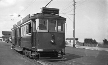 Ballarat Tramway Museum
Photograph - B&W print of donated negative, Ron E. Fluck, 7/04/1950 12:00:00 AM
... ... Railway Tunnel...See Victorian Railways to '62, pages 47 and 49 re railway tunnel....Ballarat Tramway Museum South Gardens Reserve Wendouree Parade Ballarat Ballarat goldfields tramways trams Brighton Beach VR Railway Tunnel tram 34 Black and white print of a donated negative. ...Black and white print of a donated negative. Print made 8/1998. Photo of Victorian Railway tram No.34 at the Brighton Beach terminus. Tram has the destination of "St Kilda Rly Stn". In the overhead can be seen the pan for assisting the driver to put the rear pole onto the wire. Also in the background of the photo is a stone wall of the railway tunnel under the road that served the Brighton Beach Pier. Photo taken 7-4-1950. See Victorian Railways to '62, pages 47 and 49 re railway tunnel.tramways, trams, brighton beach, vr, railway tunnel, tram 34 -
 Marysville & District Historical Society
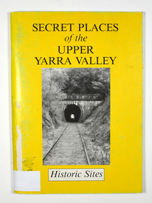
Book, Secret Places of the Upper Yarra Valley-Historic Sites, 1994
... Front cover has a black and white photograph of a railway tunnel at Healesville....Front cover has a black and white photograph of a railway tunnel at Healesville. Secret Places of the Upper Yarra Valley-Historic Sites Book Book Steenhuis, Luke ...A book describing historic sites in the Upper Yarra ValleyPaperback. Front cover has a black and white photograph of a railway tunnel at Healesville.A collection of places within the Upper Yarra/ Valley significant to the understanding of our/ heritage./ Aborigines, white explorers, pastoralists, gold/ miners and timber cutters have all left their mark./ These are sites which, despite modern/ development and urbanisation of our valley, are/ still able to give us an insight to an eventful past. Stamp of Marysville & District / Historical Society Inc / P.O. Box 22 / Marysville 3779upper yarra valley, history, historic sites -
 Ringwood and District Historical Society
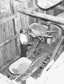
Photograph, Concreting drainage tunnel under railway at East Ringwood, 1967
... Concreting drainage tunnel under railway at East Ringwood, 1967....Written under photograph, "Tunnel under railway at East Ringwood. Written on rear of photograph, "CONCRETING DRAINAGE TUNNEL UNDER RAILWAY AT EAST RINGWOOD 1967"...Ringwood and District Historical Society 125A Warrandyte Road Ringwood North melbourne Written under photograph, "Tunnel under railway at East Ringwood. Written on rear of photograph, "CONCRETING DRAINAGE TUNNEL UNDER RAILWAY AT EAST RINGWOOD 1967" Black and white photograph Concreting drainage tunnel under railway at East Ringwood, 1967. ...Black and white photographWritten under photograph, "Tunnel under railway at East Ringwood. Written on rear of photograph, "CONCRETING DRAINAGE TUNNEL UNDER RAILWAY AT EAST RINGWOOD 1967" -
 Eltham District Historical Society Inc
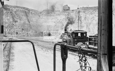
Photograph, D-class Diesel Locomotive D-1, Fyansford Cement Works Railway, November 1962, 1962
... d-1, d-class diesel locomotive,fyansford, fyansford cement works railway, george coop collection, railway tunnel, T-413...Eltham District Historical Society Inc 728 Main Rd Eltham melbourne This became T413 when sold to the Victorian Railways, re-gauged to 5’3”, and used on the hilly Cudgewa line because loco was fitted with dynamic brakes. d-1, d-class diesel locomotive,fyansford, fyansford cement works railway, george coop collection, railway tunnel, T-413 Digital TIFF file Scan of 35mm Ilford FP3 black and white negative transparency D-class Diesel Locomotive D-1, Fyansford Cement Works Railway, November 1962 Photograph Photograph George Coop George Coop ...This became T413 when sold to the Victorian Railways, re-gauged to 5’3”, and used on the hilly Cudgewa line because loco was fitted with dynamic brakes.Digital TIFF file Scan of 35mm Ilford FP3 black and white negative transparencyd-1, d-class diesel locomotive,fyansford, fyansford cement works railway, george coop collection, railway tunnel, t-413 -
 Eltham District Historical Society Inc
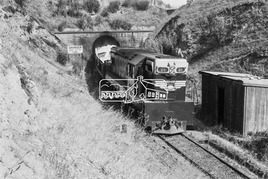
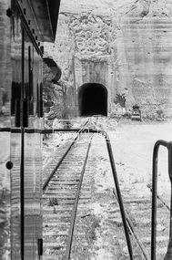
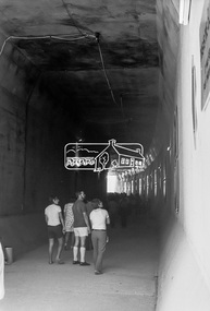
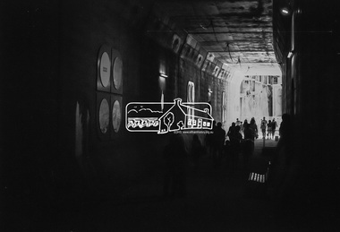
Photograph, Exiting the tunnel, Fyansford Cement Works Railway, November 1962, 1962
... Exiting the tunnel, Fyansford Cement Works Railway, November 1962...Fyansford Cement Works Railway, George Coop Collection, Railway Tunnel...Eltham District Historical Society Inc 728 Main Rd Eltham melbourne Fyansford Cement Works Railway, George Coop Collection, Railway Tunnel Digital TIFF file Scan of 35mm Ilford FP3 black and white negative transparency Exiting the tunnel, Fyansford Cement Works Railway, November 1962 Photograph George Coop George Coop ...Digital TIFF file Scan of 35mm Ilford FP3 black and white negative transparencyfyansford cement works railway, george coop collection, railway tunnel -
 Eltham District Historical Society Inc
Photograph, A Vulcan Iron Works 0-6-0SToc locomotive, Fyansford Cement Works Railway, November 1962, 1962
... Fyansford Cement Works Railway, George Coop Collection, Railway Tunnel, Vulcan Iron Works 0-6-0SToc locomotive...Eltham District Historical Society Inc 728 Main Rd Eltham melbourne Fyansford Cement Works Railway, George Coop Collection, Railway Tunnel, Vulcan Iron Works 0-6-0SToc locomotive Digital TIFF file Scan of 35mm Ilford FP3 black and white negative transparency A Vulcan Iron Works 0-6-0SToc locomotive, Fyansford Cement Works Railway, November 1962 Photograph George Coop George Coop ...Digital TIFF file Scan of 35mm Ilford FP3 black and white negative transparencyfyansford cement works railway, george coop collection, railway tunnel, vulcan iron works 0-6-0stoc locomotive -
 Eltham District Historical Society Inc
Photograph, Fyansford Cement Works Railway, November 1962, 1962
... fyansford cement works railway, george coop collection, railway tunnel...Eltham District Historical Society Inc 728 Main Rd Eltham melbourne fyansford cement works railway, george coop collection, railway tunnel Digital TIFF file Scan of 35mm Ilford FP3 black and white negative transparency Fyansford Cement Works Railway, November 1962 Photograph George Coop George Coop ...Digital TIFF file Scan of 35mm Ilford FP3 black and white negative transparencyfyansford cement works railway, george coop collection, railway tunnel -
 Eltham District Historical Society Inc
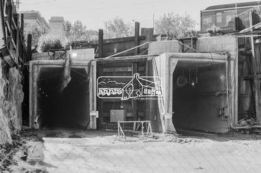
Photograph, George Coop, Open Day to view the Melbourne Underground Rail Loop (City Loop) construction, c.1980, 1983
... City Loop, Melbourne Underground Rail Loop (MURL), Railway construction, Tunnel...Eltham District Historical Society Inc 728 Main Rd Eltham melbourne City Loop, Melbourne Underground Rail Loop (MURL), Railway construction, Tunnel Digital TIFF file Scan of 35mm Kodak Plus-X Pan black and white transparency Open Day to view the Melbourne Underground Rail Loop (City Loop) construction, c.1980 Photograph George Coop ...Digital TIFF file Scan of 35mm Kodak Plus-X Pan black and white transparencycity loop, melbourne underground rail loop (murl), railway construction, tunnel -
 Eltham District Historical Society Inc
Photograph, George Coop, Open Day to view the Melbourne Underground Rail Loop (City Loop) construction, c.1980, 1983
... city loop, melbourne underground rail loop (murl), railway construction, tunnel...Eltham District Historical Society Inc 728 Main Rd Eltham melbourne city loop, melbourne underground rail loop (murl), railway construction, tunnel Digital TIFF file Scan of 35mm Kodak Plus-X Pan black and white transparency Open Day to view the Melbourne Underground Rail Loop (City Loop) construction, c.1980 Photograph George Coop ...Digital TIFF file Scan of 35mm Kodak Plus-X Pan black and white transparencycity loop, melbourne underground rail loop (murl), railway construction, tunnel -
 Coal Creek Community Park & Museum
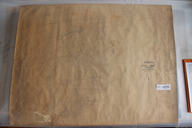
Mine Map
... 6295.1 - Large map of Korumburra coal mine; shows seams, tunnels, railways, roads and Leura Creek. There is a grid over the main area and a scale legend....Coal Creek Community Park & Museum 12 Silkstone Road Korumburra gippsland 6295.1 - Large map of Korumburra coal mine; shows seams, tunnels, railways, roads and Leura Creek. There is a grid over the main area and a scale legend. ...6295.1 - Large map of Korumburra coal mine; shows seams, tunnels, railways, roads and Leura Creek. There is a grid over the main area and a scale legend. -
 Whitehorse Historical Society Inc.
Article, $80m tunnel plan to solve eastern suburb bottleneck, 2004
... Article about proposal to build two tunnels in Springvale Road, Nunawading under Whitehorse Road and the railway line. ...Article about proposal to build two tunnels in Springvale Road, Nunawading under Whitehorse Road and the railway line. ...Article about proposal to build two tunnels in Springvale Road, Nunawading under Whitehorse Road and the railway line.Article about proposal to build two tunnels in Springvale Road, Nunawading under Whitehorse Road and the railway line. The tunnels are proposed by Whitehorse City Council.Article about proposal to build two tunnels in Springvale Road, Nunawading under Whitehorse Road and the railway line. springvale road, nunawading, whitehorse road, nunawading, city of whitehorse, duff, noelene, springvale road tunnels -
 Kiewa Valley Historical Society
Photograph KHS Rail, Kiewa Hydroelectric Scheme Railway, Circa1940s
... This photograph shows part of the railway constructed and used for the removal of soil and rocks from the tunnels bored out of the mountains for the pipeline servicing the Hydro Electricity power stations in the Kiewa Hydroelectric Scheme. ...Picture is of a section of railway track servicing the tunnels of the Hydroelectric scheme during the 1940s - 1950s...Picture is of a section of railway track servicing the tunnels of the Hydroelectric scheme during the 1940s - 1950s Kiewa Hydroelectric Scheme Railway Photograph KHS Rail Mr. ...This photograph shows part of the railway constructed and used for the removal of soil and rocks from the tunnels bored out of the mountains for the pipeline servicing the Hydro Electricity power stations in the Kiewa Hydroelectric Scheme. This photo details an era when there were 4,000 construction workers located in two main accommodation camps, Mount Beauty (the larger one) and Bogong village. These accommodation sites were constructed and maintained as a secured or gated residential area with access only available by a special pass authorised by the Kiewa Hydroelectric Scheme. All the power used by the rail system was from electric motors connected to batteries. Overhead power poles seen on either side of the embankment details that electricity from the Scheme was in use. This use was cleaner and more environmentally friendly than the coal still used by large locomotives from city to country railways. The worker shown is not however wearing protective head and hand coverings. This is also an era where there was a lack of health and safety legislation covering workers in dangerous working conditions.Scanned photo of original black and white photo on Kodak XtraLife II paper. Picture is of a section of railway track servicing the tunnels of the Hydroelectric scheme during the 1940s - 1950sOn back of photo "Kodak XtraLife II paper"railway in kiewa electric scheme, tunneling -
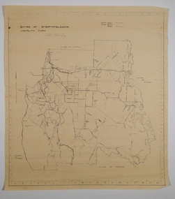 Bendigo Historical Society Inc.
Map - CAMPBELL COLLECTION: BENDIGO AND DISTRICT MAPS, 21-8-1972
... Melbourne to Bendigo Railway Line, Big Hill Tunnel, Mt.Herbert 1596.Axedale Township, Strathfieldsaye Township....Melbourne to Bendigo Railway Line, Big Hill Tunnel, Mt.Herbert 1596.Axedale Township, Strathfieldsaye Township. ...Map. Shire of Strathfieldsaye, Locality Plan. Scale I inch=1 mile. Shire of Huntly, Shire of McIvor, City of Bendigo, Shire of Marong, Shire of Maldon, Shire of Metcalfe. Lake Eppalock. Mileage markers on some roads. Melbourne to Bendigo Railway Line, Big Hill Tunnel, Mt.Herbert 1596.Axedale Township, Strathfieldsaye Township.M.Higgs 21-8-1972map, bendigo, locality plan -
 Kew Historical Society Inc
Album - Photographs of heritage sites in Victoria, Eva Grant, 1964-66
... . | Jolimont (Vic.) - Old railway tunnel linking the first Government House (1964); Sign identifying location of first Government House. | Kew (Vic.) - Cairn at Dight’s Falls; Canoe tree, Bowyer Avenue. | Kyneton - De Grave’s Flour Mill - “C”. | Maldon (Vic.) - Chinese oven; Macarthur’s House; Maldon’s oldest resident; Chinese graves x 2; [Beehive Chimney]. | Marysville (Vic.) - Centenary cairn | Mitcham (Vic.), Mud brick house x 2, Deep Creek Road. | Melbourne (Vic.) - St Paul’s Cathedral [renovation] (1964); Wreckers at Damman’s Corner, cnr Bourke and Collins Streets (1964); Princess Gate project x 2 (1964); Colonial Storekeeper’s building on cnr King and Bourke Streets (1966); Early observatory 1861-3; the Honey Memorial. | Mt Oberon (Vic.) - [obsolete] radio telephone dish. | Seymour (Vic.) - Habres (sic) House x 3.| Swan Hill (Vic.) - Major Mitchell’s Cairn (12/1964); Headstone of Andrew Beverage AM (12/1964). | Templestowe (Vic.) - Finn’s Hotel. | Thornton (Vic.) - Eildon Station. | Werribee (Vic.) - Chirnside Memorial [Presbyterian] Church; gaslight beside church | Location unknown, but possibly Swan Hill - Brick house; Wooden bullock dray. | Location unknown - Headstone of John Furlonge 1835..... | Jolimont (Vic.) - Old railway tunnel linking the first Government House (1964); Sign identifying location of first Government House. | Kew (Vic.) - Cairn at Dight’s Falls; Canoe tree, Bowyer Avenue. | Kyneton - De Grave’s Flour Mill - “C”. | Maldon (Vic.) - Chinese oven; Macarthur’s House; Maldon’s oldest resident; Chinese graves x 2; [Beehive Chimney]. | Marysville (Vic.) - Centenary cairn | Mitcham (Vic.), Mud brick house x 2, Deep Creek Road. | Melbourne (Vic.) - St Paul’s Cathedral [renovation] (1964); Wreckers at Damman’s Corner, cnr Bourke and Collins Streets (1964); Princess Gate project x 2 (1964); Colonial Storekeeper’s building on cnr King and Bourke Streets (1966); Early observatory 1861-3; the Honey Memorial. | Mt Oberon (Vic.) - [obsolete] radio telephone dish. | Seymour (Vic.) - Habres (sic) House x 3.| Swan Hill (Vic.) - Major Mitchell’s Cairn (12/1964); Headstone of Andrew Beverage AM (12/1964). | Templestowe (Vic.) - Finn’s Hotel. | Thornton (Vic.) - Eildon Station. | Werribee (Vic.) - Chirnside Memorial [Presbyterian] Church; gaslight beside church | Location unknown, but possibly Swan Hill - Brick house; Wooden bullock dray. | Location unknown - Headstone of John Furlonge 1835. ...Eva Grant was a member of the Kew Historical Society. Three albums in the collection were created by her, this one, the third created between 1964 and 1966. They were donated to the Society by her daughter in 2010. Each of the albums includes photographs and newspaper cuttings collected on her travels to historic places in South East Australia in the 1950s and 1960s. Particular structures photographed in this album include: Barnawatha (Vic.) - The Hermitage | Beveridge (Vic.) - Stone cottage where Ned Kelly was born. | Brighton - St Andrew’s Church graveyard. | Chiltern (Vic.) - lake view [missing] | Cowes (Vic.) - ‘Broadwater’ [originally home of Henty-Wilson family], demolished 1965; Bell of the Speke wreck; Edward’s tree. | Euroa (Vic.) - Habbies Howe | Fairfield (Vic.) - Dight’s Falls; John Dight. | Fernshawe (Vic.) - Queen Mary tree. | Jolimont (Vic.) - Old railway tunnel linking the first Government House (1964); Sign identifying location of first Government House. | Kew (Vic.) - Cairn at Dight’s Falls; Canoe tree, Bowyer Avenue. | Kyneton - De Grave’s Flour Mill - “C”. | Maldon (Vic.) - Chinese oven; Macarthur’s House; Maldon’s oldest resident; Chinese graves x 2; [Beehive Chimney]. | Marysville (Vic.) - Centenary cairn | Mitcham (Vic.), Mud brick house x 2, Deep Creek Road. | Melbourne (Vic.) - St Paul’s Cathedral [renovation] (1964); Wreckers at Damman’s Corner, cnr Bourke and Collins Streets (1964); Princess Gate project x 2 (1964); Colonial Storekeeper’s building on cnr King and Bourke Streets (1966); Early observatory 1861-3; the Honey Memorial. | Mt Oberon (Vic.) - [obsolete] radio telephone dish. | Seymour (Vic.) - Habres (sic) House x 3.| Swan Hill (Vic.) - Major Mitchell’s Cairn (12/1964); Headstone of Andrew Beverage AM (12/1964). | Templestowe (Vic.) - Finn’s Hotel. | Thornton (Vic.) - Eildon Station. | Werribee (Vic.) - Chirnside Memorial [Presbyterian] Church; gaslight beside church | Location unknown, but possibly Swan Hill - Brick house; Wooden bullock dray. | Location unknown - Headstone of John Furlonge 1835.Important record of significant heritage properties in Victoria, many of which have since been demolished.30 page spirex bound drawing book including photographs and newspaper articles of historic buildings in Victoria. The front cover has a picture of a steam boat. The cover is encased in plastic. A number items in the album are annotated with written commentary by Eva Grant who compiled the album. Annotations and transcriptions by Eva Grant on most imageseva grant, photograph albums, heritage places - victoria -
Bendigo Historical Society Inc.
Map - CAMPBELL COLLECTION: BENDIGO AND DISTRICT MAPS, 21-8-1972
... Drawn by M.Higgs 21-8-1972, Shire of Huntly, Shire of McIvor, City of Bendigo, Shire of Marong, Shire of Maldon, Shire of Metcalfe, Lake Eppalock, Axedale Township, Strathfieldsaye Township, Melbourne to Bendigo Railway Line, Big Hill Tunnel, Mt.Herbert 1596. (number 398 in map cupboard 1)...Drawn by M.Higgs 21-8-1972, Shire of Huntly, Shire of McIvor, City of Bendigo, Shire of Marong, Shire of Maldon, Shire of Metcalfe, Lake Eppalock, Axedale Township, Strathfieldsaye Township, Melbourne to Bendigo Railway Line, Big Hill Tunnel, Mt.Herbert 1596. (number 398 in map cupboard 1) Map CAMPBELL COLLECTION: BENDIGO AND DISTRICT MAPS ...Map. Shire of Strathfieldsaye Locality Plan. Scale 1 inch=1 mile. Drawn by M.Higgs 21-8-1972, Shire of Huntly, Shire of McIvor, City of Bendigo, Shire of Marong, Shire of Maldon, Shire of Metcalfe, Lake Eppalock, Axedale Township, Strathfieldsaye Township, Melbourne to Bendigo Railway Line, Big Hill Tunnel, Mt.Herbert 1596. (number 398 in map cupboard 1)M.Higgs 21-8-1972map, bendigo, locality plan -
 Bendigo Historical Society Inc.
Photograph - NICHOLAS CAIRE VIEWS OF BENDIGO
... Paul's tower looking south west. 39) View of the railway tunnel through the Big Hill, near Mt. Herbert. 40) View taken from St. ...Paul's tower looking south west. 39) View of the railway tunnel through the Big Hill, near Mt. Herbert. 40) View taken from St. ...Full set (52 photos) of Nicholas Caire ''Views of Bendigo'' photographs. 1) Sandhurst East with a portion of the City Reserve. 2) New Chum line of reef. 3) Sandhurst-North part as seen from the top of the Masonic Hall. 4) The Hustler's line of reef seen from Redan Hill. 5) Battery of stampers for crushing quartz 6) View of Sandhurst as seen from the top of the New Masonic Hall. 7) Excavation of quartz reef near Ironbark Hill. 8) St. Paul's Church, tower and belfry. 9) View of the Camp Reserve as seen from the Court House. 10) View of North Old Chum showing surface excavations. 11) View as seen from the Camp Hill near the lodge. 12) Garden Gully amalgamated claims. 13) Shamrock Hotel, Sandhurst. 14) View as seen from Court House showing the willows & East Pall Mall. 15) Wesleyan Church, Golden Square. 16) Savings bank, Sandhurst. 17) The Bendigo district hospital. 18) Interior of the Wesleyan Church, Golden Square. 19) View of Golden Square township. 20) The Town Hall, City of Sandhurst. 21) The City Hotel, Sandhurst. 22) Pall Mall, Sandhurst. 23) Sandhurst City Market. 24) Pall Mall, Sandhurst looking west. 25) View from Camp Hill looking north - east 26) View of Charing Cross, Sandhurst. 27) View of Sandhurst as seen from Knipe's Castle. 28) Township of Long Gully. 29) View taken from St. Paul's tower. 30) View of the Sandhurst cemetery at back creek. 31) Kock's pioneer quartz crushing plant, Long Gully. 32) The New Masonic Hall, Sandhurst. 33) The Bendigo benevolent asylum and industrial school. 34) Bendigo flat as seen from Wattle Hill. 35) View of Old Chum Hill. 36) New Chum Gully as seen from Specimen Hill. 37) Township of Eaglehawk. 38) View from St. Paul's tower looking south west. 39) View of the railway tunnel through the Big Hill, near Mt. Herbert. 40) View taken from St. Paul's looking south. 41) Scene taken from St. Paul's tower looking eastward. 42) View of Sandhurst from St. Paul's tower looking north-west. 43) The great extended Hustler's co's. quartz mining claim. 44) View from the Big Hill showing the line of railway to Melbourne. 45) View from St. Paul's Church tower looking westward. 46) View from St. Paul's Church tower looking north-west. 47) Scene near the Big Hill ranges taken from Mr. Buick's residence. 48) View from St. Paul's Church tower looking north eastward. 49) Township of Eaglehawk 50) View of Mitchell Street, Sandhurst. 51) Botanical gardens near the White Hills. 52) View Point, Sandhurst.bendigo, streetscape, various views, nicholas cairne -
 Sunshine and District Historical Society Incorporated
Photograph - Ashley Street Railway Underpass Photographs
... The work involved to solve this problem was to elevate the railway yard and place Ashley Street through a tunnel. This railway underpass for many years was simply known as the Ashley Street Tunnel. ...The work involved to solve this problem was to elevate the railway yard and place Ashley Street through a tunnel. This railway underpass for many years was simply known as the Ashley Street Tunnel. ...The Tottenham Yard began as a modest goods yard supporting local industries in Braybrook, Tottenham, and West Footscray, the Sunshine industrial belt and the nearby munitions and explosives factories Key features of the early yard included a small number of sidings, a goods shed, a basic loading / unloading facilities and a connection to the Tottenham triangle (Sunshine–Footscray–North Melbourne junction). As the yard expanded with additional siding and larger marshalling areas, there was a requirement to maintain the Ashley Street North – South access route for private and commercial travel. The work involved to solve this problem was to elevate the railway yard and place Ashley Street through a tunnel. This railway underpass for many years was simply known as the Ashley Street Tunnel. By the 1970s, the Tottenham Yard had become one of the largest freight yards in Victoria, second only to Dynon. In the 1982, the level crossing gates at the southern end of tunnel were removed, the tunnel extended southwards and the former Tottenham Railway Station was replaced with an elevated one above the new tunnel extension. During these works the road surface level was lowered to allow for higher trucks to pass through. At this point of time, the reference to tunnel was replaced with underpass. During the 1990’s and 2000’s, there was a decline in the use of the Tottenham Yard and many sidings were removed, shorten, converted to storage or left unused. Today the yard is used for wagon storage, crew changes, light shunting and providing access to the Tottenham triangle and Sunshine corridor.These photographs were taken shortly after the tunnel was completed.5335.01 - Ashley Street Railway Underpass Looking North Photo 01.jpg 5335.02 - Ashley Street Railway Underpass Looking South Photo 02.jpgashley street, railway line, tottenham -
 Eltham District Historical Society Inc
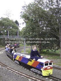
Photograph - Digital Photograph, Marguerite Marshall, Diamond Valley Railway, Eltham Lower Park, 7 September 2008
... services its passengers – the largest number of any miniature railway in Australia – with a fleet including: six diesel locomotives, three steam locomotives, eight sets of passenger cars and one battery electric Dog Box set. Members also privately own 20 locomotives and powered carriage sets as well as four carriage sets.1 All the trains are stored on-site in workshops, sheds and a tunnel. ... services its passengers – the largest number of any miniature railway in Australia – with a fleet including: six diesel locomotives, three steam locomotives, eight sets of passenger cars and one battery electric Dog Box set. Members also privately own 20 locomotives and powered carriage sets as well as four carriage sets.1 All the trains are stored on-site in workshops, sheds and a tunnel. ...Kids of all ages enjoy the Miniature Railway. Published: Nillumbik Now and Then / Marguerite Marshall 2008; photographs Alan King with Marguerite Marshall.; p163 On Sundays in Eltham thousands of children, mums, dads and grandparents can be seen travelling around Lower Eltham Park in tiny trains. They are among the two and half million passengers who have travelled on the Diamond Valley Railway since it officially began in 1961. The miniature railway originally operated from the 1940s at Chelsworth Park, Ivanhoe, until flooding caused it to be moved to the Eltham Lower Park in 1959. The railway is modelled on the 1920s era – the heyday of passenger rail travel – and the trains are built on a scale of two inches to the foot (1/6). Although not exact replicas, trains include models of the Spirit of Progress, Puffing Billy, The Overland, Dog Boxes, Vic Rail S class, G class and a NSW 81 Class. The three and a half kilometres of track is set amongst native plants and picnic areas. A friendly hoot or the clang of a bell occasionally punctuates the tranquillity as a train emerges from a treed bend with passengers excitedly waving to onlookers. For $3 the train takes you on a 13-minute two-kilometre ride. Passengers sit in single file in the narrow train, which clatters along tracks built to the scale of the Australian narrow gauge of three feet six inches (1.1m). These are used in Queensland, South Australia, Tasmania and Western Australia. Safety standards are stringently kept. Even before you buy a ticket notices tell you that you must wear closed shoes. You can even borrow these, and you are given a pair of socks for the ride! Blue-overalled volunteers check tickets, see you aboard, and drive the train. They are mainly retired men who can at last devote their time to what little boys dream of – playing with trains. Passengers are instructed in safe behaviour, then the station master waves a white flag and off we go. The guard sits at the back with his whistle and green flag at the ready. The winding track, fringed by native trees and bushes planted by volunteers, stands on crown land managed by Nillumbik Council. The train clatters along the track and crosses a bridge over a drain elevated by name to The Blow Fly Creek. We pass by Meadmore Junction at a speed of three kilometres an hour. Then on through a tunnel, accompanied by squeals of delight, and after a few moments of blackness, light glimmers at the end. On we go, past the original platform, along another route past busy Main Road through Pine Creek Station, over a bridge and through another tunnel with more screams of delight.Then a signal stops us before the ‘all clear’ to return to our original point of departure. The railway services its passengers – the largest number of any miniature railway in Australia – with a fleet including: six diesel locomotives, three steam locomotives, eight sets of passenger cars and one battery electric Dog Box set. Members also privately own 20 locomotives and powered carriage sets as well as four carriage sets.1 All the trains are stored on-site in workshops, sheds and a tunnel. The railway is entirely run by volunteers, so that all ticket money is used for maintenance and extensions, and some goes to local charities. Since 1991, the entire railway has been rebuilt, including an upgraded signalling system. About half of the 120 volunteer members are active with about 35 working each Sunday, and a dozen or so working every Wednesday. Members are trained to positions of station assistant, booking officer, train guard, train driver or signalman. Members construct new carriages and locomotives as well as maintaining track, signalling and rolling stock.This collection of almost 130 photos about places and people within the Shire of Nillumbik, an urban and rural municipality in Melbourne's north, contributes to an understanding of the history of the Shire. Published in 2008 immediately prior to the Black Saturday bushfires of February 7, 2009, it documents sites that were impacted, and in some cases destroyed by the fires. It includes photographs taken especially for the publication, creating a unique time capsule representing the Shire in the early 21st century. It remains the most recent comprehenesive publication devoted to the Shire's history connecting local residents to the past. nillumbik now and then (marshall-king) collection, diamond valley railway, eltham lower park -
Federation University Historical Collection
Letter, Inward Correspondence to the Ballarat School of Mines, 1910, 08/1910
... Hull Birthday Tunnel Company L. Hansen Victorian Railways Edmund C. Earles Lawrence R. ...Inward Correspondence to the Ballarat School of Mines, August 1910letterhead, education department, roland graham, coleraine, m. carew, row brothers, mount gambier, joseph row, r. blackburn, max kohl, wilfred p. avery, jubilee hall, broken hill, frederick e. barclay, pharmacy board victoria, harry shinningham, hobson's gold mining company, macquarie steam brick yards, james dewar, henrey sotheran & co, piccadilly, london, salop, thomas parker, frank tate, dressmaking, steiglitz, telegram, postcard, lahasa fiji, r. palmerf, church of england grammar school of girls, f. abrams, radium hill, welcome gold mine, stanley b. white, new golden gate gold mining company, n.j. wise, h.g. taylor, kout morrien harrow, l.f. fairthorne & sons, h.b. silberberg & co, skipton, henry f. hull, birthday tunnel company, l. hansen, victorian railways, edmund c. earles, lawrence, r. welesteo, wellington cyanide works, clunes, octavius williams, h.j. thwaites, tolarno station, gilbert pa, gilbert palmer, wool sorting, r.j. webster, w.a.t. davies, henry markwald, e. rolland -
 Orbost & District Historical Society
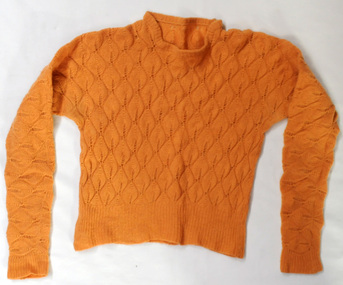
knitted jumper, 1938-1940
... However, pre-existing structures such as underground stations (tube or subway stations), tunnels, cellars in houses or basements in larger establishments, and railway arches, above ground, were suitable for safeguarding people during air raids. ...However, pre-existing structures such as underground stations (tube or subway stations), tunnels, cellars in houses or basements in larger establishments, and railway arches, above ground, were suitable for safeguarding people during air raids. ...This was knitted by Marjorie Burton during WW11 in England. She used to knit while in an air raid shelter escaping the bombing with her young daughter. Air raid shelters were built specifically to serve as protection against enemy air raids. However, pre-existing structures such as underground stations (tube or subway stations), tunnels, cellars in houses or basements in larger establishments, and railway arches, above ground, were suitable for safeguarding people during air raids. This item is an example of a handcrafted item and reflects the handcraft skills of women necessary during WW11 when clothing became scarce. Clothes rationing began on June 1, 1941, two years after food rationing started. Clothes rationing ended on 15 March 1949.A hand-knitted orange/tan woolen jumper. It is a lady's long-sleeved jumper.handcraft knitting ww11 -
Federation University Historical Collection
Book, Jacobs Lewis Vines Architects and Conservation Planners, Historic Sites Survey: Ballarat Study Area, 1980, 1980
... Barker Library (top floor) Mount Helen goldfields This survey was commissioned by the Land Conservation Council, Australian Heritage Commission and the Ministry for Conservation historic sites ballarat Wendy jacobs miles lewis gary vines berringa buninyong creswick dunnstown fiery creek lal lal langi logan cathcart mount cole Mount Egerton nerrina gong gong wombat state forest railways explorers routes early roads land conservation council ausralian hertiage commission department of planning ICOMOS (Burra) Charter nigel lewis richard aitken freehold land public land langi ghiran New jubille mine birthday tunnel mine pitfield plains smythesdale buninyong company Mount Clear mt clear canadian gully Warrenheip Distillery thomas mitchell waterloo trawalla beaufort raglan internment camps forestry mining mining mt egerton Mary Hollick Collection Jubilee Mine Burra Charter Historica areas data form explorers Egerton Company Black Horse mine Mt Egerton Government Battery kaolin Mines Anderson Brothers Barkstead Anderson's Tramway Clarkesdale Berry Leads Birthday Tunnel Mine Berringa Warrenheip Australasian Company Mount Mercer Lanvi-Kal-Kal water race 114 page report on historic sites in the Ballarat region. ...This survey was commissioned by the Land Conservation Council, Australian Heritage Commission and the Ministry for Conservation 114 page report on historic sites in the Ballarat region. It includes information on sites, a schexdule of sites, silte selection and designated areas (ie around towns)historic sites, ballarat, wendy jacobs, miles lewis, gary vines, berringa, buninyong, creswick, dunnstown, fiery creek, lal lal, langi logan, cathcart, mount cole, mount egerton, nerrina, gong gong, wombat state forest, railways, explorers routes, early roads, land conservation council, ausralian hertiage commission, department of planning, icomos (burra) charter, nigel lewis, richard aitken, freehold land, public land, langi ghiran, new jubille mine, birthday tunnel mine, pitfield plains, smythesdale, buninyong company, mount clear, mt clear, canadian gully, warrenheip distillery, thomas mitchell, waterloo, trawalla, beaufort, raglan, internment camps, forestry, mining, mining, mt egerton, mary hollick collection, jubilee mine, burra charter, historica areas data form, explorers, egerton company, black horse mine, mt egerton government battery, kaolin mines, anderson brothers, barkstead, anderson's tramway, clarkesdale, berry leads, birthday tunnel mine berringa, warrenheip, australasian company, mount mercer, lanvi-kal-kal, water race -
 Eltham District Historical Society Inc
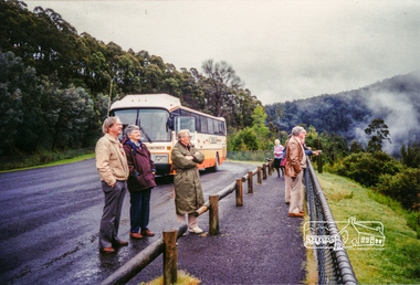
Photograph, Upper Yarra Dam, Spring Tour, 22 Oct 1995, 22/10/1995
... Railway Station at Launching Place the Centennial Trail for walkers, cyclists and ' horse riders has replaced the rails. The line from Lilydale was opened in 1901, and the last diesel freight train ran to Warburton in 1965. It continued to rain as we had morning tea in Warburton in a shelter between footbridges. From here we continued upstream past the Bridge to O'Shannasy Lodge and Reservoir, Starvation Creek, and the Peninsular tunnel...Railway Station at Launching Place the Centennial Trail for walkers, cyclists and ' horse riders has replaced the rails. The line from Lilydale was opened in 1901, and the last diesel freight train ran to Warburton in 1965. It continued to rain as we had morning tea in Warburton in a shelter between footbridges. From here we continued upstream past the Bridge to O'Shannasy Lodge and Reservoir, Starvation Creek, and the Peninsular tunnel ...EXPLORING THE UPPER YARRA (Newsletter No. 105, November 1995, by Bettina Woodburn) We enjoyed the Spring Excursion, this year "Exploring the Upper Yarra" - in spite of the constant rain and the countryside under the cloud cover, especially in the valleys, being mainly shiny shades of green. The occasional fields of buttercups, clumps of arum lilies and splendid rhododendron and other flowering bushes became very special. The Cobb and Co coach was warm and a cosy retreat as we zig-zagged on the highways and byways to glimpse the Yarra River, upstream and down, its secret places, and particularly the many bridges. Russell excelled as 'Poet Laureate', reading from Dacre Smyth's book. This 1979 publication includes paintings of all the bridges along the river with poems and brief descriptions of each one. Some of the bridges are in out of the way places and are not very well known. We looked forward to hearing the poetry as much as seeing the ' constructions'…Big Pat (was he short or tall, lean or fat? He did win the two hundred pound reward for discovering gold and had the creek named after him), about the 'Eddies'?, and the disliked 'meccano' bridge in Warburton, etc. etc. The hot roast lunch in the old Reefton Hotel was also most welcome. It was easy to imagine it peopled by miners and early settlers. Starting by crossing the new (1974) concrete bridge at Warrandyte we headed through Wonga Park with views to the Christmas Hills and to the escarpment of the Yering Gorge, which causes flood waters to back up through the Yarra Glen plain, so avoiding disasters downstream. At the end of a long driveway we found the wooden, privately owned Henley Bridge (1935 after the 1934 floods). This facilitates access to different parts of Henley Farm and to Lilydale. Everard Park, named after Blanche Shallard's father, a State Member for 17 years, below the Highway Yarra crossing was in need of care. It is 10 miles from Yarra Glen by road but, as "Yarra Marra” canoeists well know, 32 winding miles down by water. After more delightful countryside scenes we joined the Warburton Highway at Woori Yallock. From the old Railway Station at Launching Place the Centennial Trail for walkers, cyclists and ' horse riders has replaced the rails. The line from Lilydale was opened in 1901, and the last diesel freight train ran to Warburton in 1965. It continued to rain as we had morning tea in Warburton in a shelter between footbridges. From here we continued upstream past the Bridge to O'Shannasy Lodge and Reservoir, Starvation Creek, and the Peninsular tunnel (miners dug it as at Pound Bend) which we visited (scrambling down those steps!) on our return after lunch. Our furthermost point was the Upper Yarra Dam Reserve (and vast catchment area). Finished in 1957 after ten years work and 100 years after Yan Yean, it supplies much of Melbourne's water. After crossing the 30m Launching Place Bridge to the Eltham side of the Yarra and Healesville, we saw in the distance the Yarra Glen Timber Trestle Bridge over the river flats "the longest for years in the land it was said!" Harry's dream of "better weather over the Divide" unfortunately didn't come true, but I'm sure we 36 members will retain happy memories of a day that was wet and green and filled with Bridges. Bettina Woodburn - October 1995 Record of the Society's history of activities - Spring 1995 excursionColour photographshire of eltham historical society, activities, upper yarra dam, henley bridge -
 Glen Eira Historical Society
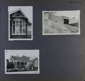
Album - Album page, Hotham Street, Circa 1972
... The survival of the riveted iron girders with their bellied angle iron struts is important since these elements are representative of the civil engineering practices of the Victorian Railways at the time and constitute the technical significance (Criterion F) of the structure. trevor hart elsternwick hotham street caulfield houses brick bay windows verandahs railway bridges tunnels gardens bluestone civil engineering victorian railways sharp and campbell contractors Handwritten: Hotham Street [top right] / 112 HOTHAM ST [under top left photo] / BRIDGE OVER SANDRINGHAM RAILWAY [under top right photo] / 112 HOTHAM ST CNR MELBY AVE [under bottom left photo] / 96 [bottom right] Page 96 of Photograph Album with three photographs (one portrait and two landscape) from Hotham Street - two external views of one house and a railway bridge. ...This photograph is part of the Caulfield Historical Album 1972. This album was created in approximately 1972 as part of a project by the Caulfield Historical Society to assist in identifying buildings worthy of preservation. The album is related to a Survey the Caulfield Historical Society developed in collaboration with the National Trust of Australia (Victoria) and Caulfield City Council to identify historic buildings within the City of Caulfield that warranted the protection of a National Trust Classification. Principal photographer thought to be Trevor Hart, member of Caulfield Historical Society. Most photographs were taken between 1966-1972 with a small number of photographs being older and from unknown sources. All photographs are black and white except where stated, with 386 photographs over 198 pages.Victorian Heritage Database - Hotham Street Road Overbridge HO116 Heritage Overlay - City of Glen Eira https://vhd.heritagecouncil.vic.gov.au/places/43557 (as of 04/07/2021) The Hotham Street road overbridge is located on the Sandringham railway line between Ripponlea and Elsternwick railway stations. It is presumed to have been built by contractors Sharp and Campbell who signed a contract on 25th . November, 1881 to construct a second line of railway between Windsor and Elsternwick. This contract was completed during 1882 and the bridge may have been designed in the year when Robert Watson took over from William Elsdon as engineer in chief for the Victorian railways. It is historically, aesthetically and technically significant. It is historically significant (Criterion A) to the extent that it demonstrates the standards of construction adopted by the Victorian Railways Department when it rebuilt the lines acquired from the private railway companies, (compare the Geelong and Melbourne Railway Co's line from Newport to Geelong, acquired in 1860). It is aesthetically significant (Criterion E) as an intact nineteenth century structure of its type, many similar girder bridges having been renewed with concrete girders in recent years. The bluestone abutments demonstrate high standards of stone masonry and are representative of Departmental work of the period. This bridge forms one of a group of historic structures on the railway to Brighton Beach and therefore contributes to the line's cultural importance as a whole. The survival of the riveted iron girders with their bellied angle iron struts is important since these elements are representative of the civil engineering practices of the Victorian Railways at the time and constitute the technical significance (Criterion F) of the structure.Page 96 of Photograph Album with three photographs (one portrait and two landscape) from Hotham Street - two external views of one house and a railway bridge.Handwritten: Hotham Street [top right] / 112 HOTHAM ST [under top left photo] / BRIDGE OVER SANDRINGHAM RAILWAY [under top right photo] / 112 HOTHAM ST CNR MELBY AVE [under bottom left photo] / 96 [bottom right]trevor hart, elsternwick, hotham street, caulfield, houses, brick, bay windows, verandahs, railway bridges, tunnels, gardens, bluestone, civil engineering, victorian railways, sharp and campbell, contractors