Showing 123 items matching "railway viaduct"
-
 Orbost & District Historical Society
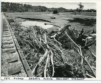
Photograph - 1971 Flood debris along railway viaduct, Orbost, 1971
... 1971 Flood debris along railway viaduct, Orbost ......Orbost railway viaduct...A b/w photo of a part of a railway bridge (viaduct) on the left hand side, along with piles of debris and a man operating machinery to the right of the photo. ...In black print written on to the bottom of the photo: '1971 flood debris along railway viaduct'....Orbost Orbost railway viaduct flood damage 1971 In black print written on to the bottom of the photo: '1971 flood debris along railway viaduct'. ...This is one of many photos taken following the devastating Snowy River flood of 1971 which inflicted huge impact on the Orbost area, including the railway bridges adjacent to the Orbost Railway Station at Newmerella (Orbost). This photo is significant because it shows the impact of the 1971 Snowy River flood on railway infrastructure at Orbost/Newmerella.A b/w photo of a part of a railway bridge (viaduct) on the left hand side, along with piles of debris and a man operating machinery to the right of the photo. A pond of water is also evident, along with paddocks and hills in the background.In black print written on to the bottom of the photo: '1971 flood debris along railway viaduct'.orbost, orbost railway viaduct, flood damage 1971 -
 Kew Historical Society Inc
Photograph, Railway Viaduct, c.1919
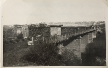
... Railway Viaduct......railway viaduct (kew)...The railway viaduct linking Kew and Fairfield was created for the Outer Circle railway....Railway viaduct, Yarra River, linking Kew and Fairfield. ...Kew Historical Society Inc Kew Court House 188 High Street Kew melbourne The railway viaduct linking Kew and Fairfield was created for the Outer Circle railway. outer circle railway railway viaduct (kew) john monash Annotations on reverse: "Outer Circle Railway Bridge (now Chandler Highway) Fairfield-Kew, about 1919. ...The railway viaduct linking Kew and Fairfield was created for the Outer Circle railway.Railway viaduct, Yarra River, linking Kew and Fairfield. Built by John Monash for the Outer Circle Railway. In 1930 converted into the Chandler Highway Bridge for vehicular traffic. The point-of-view of the photograph shows Kew in the distance. Annotations on reverse: "Outer Circle Railway Bridge (now Chandler Highway) Fairfield-Kew, about 1919. Property of Miss Foley.outer circle railway, railway viaduct (kew), john monash -
 Kew Historical Society Inc
Photograph - Outer Circle Railway Viaduct
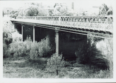
... Outer Circle Railway Viaduct...Railway Viaduct -- Kew (Vic.)...Print copy, enlarged from original snapshot, of the former railway viaduct crossing the Yarra and linking Kew and Fairfield. ...Photograph Outer Circle Railway Viaduct ...The heritage listed Fairfield Bridge was originally constructed for the Outer Circle Railway to bridge the Yarra River between East Kew and Fairfield stations. In the 1930s it was converted for vehicular traffic. In the 2010s a new concrete bridge was erected beside it to increase vehicular capacity.Print copy, enlarged from original snapshot, of the former railway viaduct crossing the Yarra and linking Kew and Fairfield. The original photo predates the conversion of the viaduct into the Chandler Highway Bridge in the 1930s, when the Bridge was adapted to carry vehicular traffic. The date on the reverse indicates the date of donation rather than the date on which the photograph was taken. CHANDLER HIGHWAY BRIDGE OVER RIVER / (ORIGINALLY PART OF OUTER CURCLE RAILWAY) / OCTOBER 1977railway viaduct -- kew (vic.), fairfield bridge, fairfield railway viaduct, outer circle railway, sir john monash -
 Kew Historical Society Inc
Photograph, Railway Viaduct, c.1900
... Railway Viaduct......railway viaduct (kew)...Railway viaduct, Yarra River, linking Kew and Fairfield. ...Kew Historical Society Inc Kew Court House 188 High Street Kew melbourne outer circle railway railway viaduct (kew) john monash chandler highway bridge Annotations on reverse: "KH-71. ...Railway viaduct, Yarra River, linking Kew and Fairfield. Built by John Monash for the Outer Circle Railway. In 1930 converted into the Chandler Highway Bridge for vehicular traffic. Annotations on reverse: "KH-71. Outer Circle Railway Bridge (over Yarra) looking from Kew side to site of Paper Mills, Alphington.outer circle railway, railway viaduct (kew), john monash, chandler highway bridge -
 Kew Historical Society Inc
Photograph, Outer Circle Railway Viaduct, 1919
... Outer Circle Railway Viaduct...railway viaduct...Railway Viaduct constructed for the Outer Circle Railway. ...Kew Historical Society Inc Kew Court House 188 High Street Kew melbourne Railway Viaduct constructed for the Outer Circle Railway. ...Railway Viaduct constructed for the Outer Circle Railway. Bridge designed by John Monash, engineer. Converted into a state highway, 1930s.Dateable photo of an important piece of Victorian railway infrastructure.Photograph of Outer Circle Railway Bridge over River Yarra, Fairfield. Looking toward Lugton Street, showing fence underneath taken from the Chandler Highway. Reverse: "Outer Circle Railway Bridge over River Yarra Fairfield, H0276, Property of Miss Foley"railway viaduct, chandler highway -
 Bendigo Historical Society Inc.
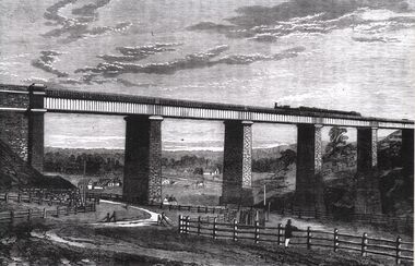
Photograph - TARADALE RAILWAY VIADUCT - ENGRAVING
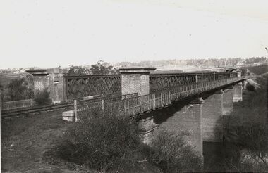
... TARADALE RAILWAY VIADUCT - ENGRAVING...Photocopy of photo: engraving shows Taradale Railway Viaduct completed. Steam train on viaduct. ...Photograph TARADALE RAILWAY VIADUCT - ENGRAVING ...Photocopy of photo: engraving shows Taradale Railway Viaduct completed. Steam train on viaduct. Stone piers supporting railway line on bridge. Underneath viaduct, post and rail fence, cottages in background.railways, bendigo to melbourne, taradale viaduct -
 Malmsbury Historical Society
Postcard (Item), Postcard Of Railway Viaduct At Malmsbury C1910, Malmsbury c1910
... Postcard Of Railway Viaduct At Malmsbury C1910, Malmsbury c1910...Buildings - Malmsbury Railway Viaduct...Malmsbury Historical Society Malmsbury Mechanics Institute 71 Mollison Street Malmsbury daylesford-and-the-macedon-ranges Buildings - Malmsbury Railway Viaduct Postcard Of Railway Viaduct At Malmsbury C1910, Malmsbury c1910 Postcard Postcard ...Buildings - Malmsbury Railway Viaduct -
 Ringwood and District Historical Society
Photograph, Maroondah Highway Central, Ringwood. Construction of Warrandyte Road railway viaduct, 1923
... Construction of Warrandyte Road railway viaduct, 1923....Typed below photograph: "Construction of Warrandyte Road railway viaduct, Ringwood - 1923." Maroondah Highway shops in background later redeveloped as the site of Safeway supermarket then Officeworks office supplies outlet, prior to Eastland Shopping Centre expansion in 2015....Construction of Warrandyte Road railway viaduct, 1923. Photograph ...Black and white photograph (2 copies)Typed below photograph: "Construction of Warrandyte Road railway viaduct, Ringwood - 1923." Maroondah Highway shops in background later redeveloped as the site of Safeway supermarket then Officeworks office supplies outlet, prior to Eastland Shopping Centre expansion in 2015. -
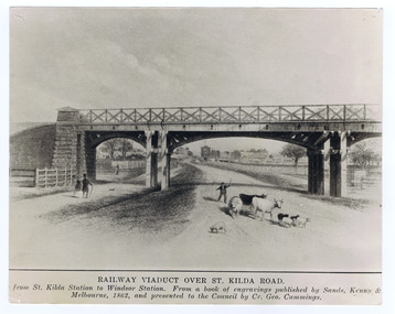 St Kilda Historical Society
Postcard, Michael Belgrove, Railway Viaduct, 1862
... Railway Viaduct...Railway Viaduct over St Kilda Road, from St. Kilda Station to Windsor Station. ...St Kilda Historical Society St Kilda Branch Library 150 Carlisle Street St Kilda melbourne Railway Viaduct over St Kilda Road, from St. Kilda Station to Windsor Station. ...Railway Viaduct over St Kilda Road, from St. Kilda Station to Windsor Station. From a book of engravings published by Sands, Kenny & McDougall, Melbourne 1862black and white photograph, copy, fair image quality, unmounted -
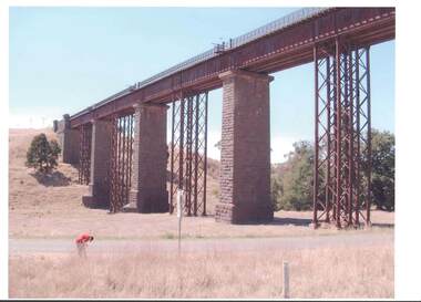 Bendigo Historical Society Inc.
Photograph - RAILWAYS COLLECTION: COLOUR PHOTO OF THE TARADALE RAILWAY VIADUCT
... RAILWAYS COLLECTION: COLOUR PHOTO OF THE TARADALE RAILWAY VIADUCT...Railways collection colour photo of a railway bridge -the Taradale Viaduct - on high stone pillars and steel girders spanning between two high areas. ...Photograph RAILWAYS COLLECTION: COLOUR PHOTO OF THE TARADALE RAILWAY VIADUCT ...Railways collection colour photo of a railway bridge -the Taradale Viaduct - on high stone pillars and steel girders spanning between two high areas. A man is seen in the foreground.photo, person -
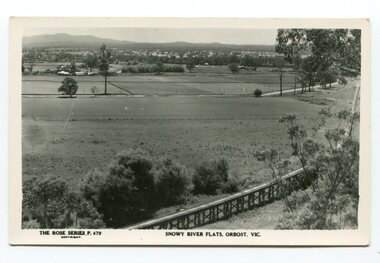 Orbost & District Historical Society
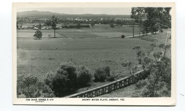
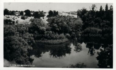
black and white photograph, Rose Stereograph Company, first half 20th century
... east-gippsland-railway orbost-viaduct...The two bridges on the railway viaduct, which crosses the Snowy River floodplain at Orbost, were built from local Southern Mahogany. ...A black / white photograph / postcard of the Orbost township in the background and the railway viaduct over the flats in the foreground....Orbost & District Historical Society Ruskin Street Orbost gippsland The two bridges on the railway viaduct, which crosses the Snowy River floodplain at Orbost, were built from local Southern Mahogany. ...The two bridges on the railway viaduct, which crosses the Snowy River floodplain at Orbost, were built from local Southern Mahogany. The bridge on the Bairnsdale end (770m) is now the longest in Victoria. Despite various attempts to extend the line, the station stayed on the western side of the Snowy River. (info. Helen Martin)This item is associated with the history of the Orbost-Bairnsdale railway line and therefore reflects the role that the rail line played in the social and economic history of Orbost.A black / white photograph / postcard of the Orbost township in the background and the railway viaduct over the flats in the foreground.photo caption - The Rose Series P.479 copywright SNOWY RIVER FLATS, ORBOST, VIC"east-gippsland-railway orbost-viaduct -
 Bendigo Historical Society Inc.
Photograph - RAILWAY VIADUCT: JACKSON'S CREEK NEAR GISBORNE VICTORIA
... RAILWAY VIADUCT: JACKSON'S CREEK NEAR GISBORNE VICTORIA...Working for laying of railway track evident, and crane like structure in centre of image. On back of photocopy: laying the first stone of the Jackson's Creek viaduct, courtesy James Lerk, Late Frank Cusack Collection....Photograph RAILWAY VIADUCT: JACKSON'S CREEK NEAR GISBORNE VICTORIA ...Photocopy of photo: image shows winding track in centre of photo, stone store on RH side, men with dray alongside. Working for laying of railway track evident, and crane like structure in centre of image. On back of photocopy: laying the first stone of the Jackson's Creek viaduct, courtesy James Lerk, Late Frank Cusack Collection.railways, bendigo to melbourne, jackson's creek viaduct -
 Orbost & District Historical Society
black and white photograph, January 1934
... orbost-flood-1934 railway-viaduct-orbost...A very faded black / white photograph of flood water under the railway viaduct at watt's Gulch....This is a pictorial record of a significant event in Orbost's history. orbost-flood-1934 railway-viaduct-orbost A very faded black / white photograph of flood water under the railway viaduct at watt's Gulch. black and white photograph ...Orbost has been subject to major floods throughout its history, such as those which left the town isolated in 1934, 1952, 1971 and 1978. It is recorded that the Snowy River broke its banks and flooded the flats 104 times between 1884 and 1978. Extensive flooding in Eastern Victoria during June 1978, caused widespread damage to roads, road closures and hazards to traffic, particularly over the Queen's Birthday holiday weekend.This is a pictorial record of a significant event in Orbost's history.A very faded black / white photograph of flood water under the railway viaduct at watt's Gulch.orbost-flood-1934 railway-viaduct-orbost -
 Orbost & District Historical Society
black and white postards, Rose Stereograph Company, 1940s -1950s
... postcards-Orbost Rose-Series Orbost-railway-viaduct Grandview-Lookout-Orbost...Three black / white postcards of views over the Orbost flats and railway viaduct. 3183.1 is of a railway viaduct in the foreground and farming flats. 3183.2 is a view over the Orbost flats taken from Grandview Lookout. 3183.3 is a view from the Grandview Lookout showing the back of a woman looking across a rail fence. ...These postcards are pictorial records of Orbost in the mid 20th century.Postcards such as these were a way of showing the scenic attractions of Orbost to potential tourists. postcards-Orbost Rose-Series Orbost-railway-viaduct Grandview-Lookout-Orbost 3183.1 - bottom front - Rose Series P 478 SNOWY RIVER FLATS, ORBOST VIC 3183.2 - bottom front - Rose Series P 49 ORBOST, FROM GRANDVIEW HEIGHTS,VIC 3183.3 - bottom front - Rose Series P 14443 A VIEW FROM THE LOOKOUT, ORBOST, VIC Three black / white postcards of views over the Orbost flats and railway viaduct. 3183.1 is of a railway viaduct in the foreground and farming flats. 3183.2 is a view over the Orbost flats taken from Grandview Lookout. 3183.3 is a view from the Grandview Lookout showing the back of a woman looking across a rail fence. black and white postards Rose Stereograph Company ...These postcards are part of the Rose series of photograph / postcards taken around Victoria. Rose was born in Clunes in 1861 and later worked in his father’s boot-making business in Prahran while studying photography. In 1880 he founded the Rose Stereograph Company and became famous for producing stereographs, or stereoviews, which gave the illusion of being in 3D when seen through a hand-held viewer, a big craze of the era. Rose produced stereoviews of the Western Front during the First World War. In all, he took about 9000 images in about 38 countries. As stereographs lost popularity in the 1920s, Rose switched to production of postcards and decorative cards, and he and the photographers who followed took thousands of scenes around Victoria as well as interstate that became iconic images of Australian life.These postcards are pictorial records of Orbost in the mid 20th century.Postcards such as these were a way of showing the scenic attractions of Orbost to potential tourists.Three black / white postcards of views over the Orbost flats and railway viaduct. 3183.1 is of a railway viaduct in the foreground and farming flats. 3183.2 is a view over the Orbost flats taken from Grandview Lookout. 3183.3 is a view from the Grandview Lookout showing the back of a woman looking across a rail fence. 3183.1 - bottom front - Rose Series P 478 SNOWY RIVER FLATS, ORBOST VIC 3183.2 - bottom front - Rose Series P 49 ORBOST, FROM GRANDVIEW HEIGHTS,VIC 3183.3 - bottom front - Rose Series P 14443 A VIEW FROM THE LOOKOUT, ORBOST, VICpostcards-orbost rose-series orbost-railway-viaduct grandview-lookout-orbost -
 Ringwood and District Historical Society
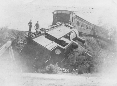
Photograph, Ringwood derailment 1902 at Wantirna Rd. railway viaduct
... Ringwood derailment 1902 at Wantirna Rd. railway viaduct...Black and white photographs - 2 copies - 1 large and 1 small Ringwood derailment 1902 at Wantirna Rd. railway viaduct Photograph ...Black and white photographs - 2 copies - 1 large and 1 smallWritten on backing sheet, "Ringwood 11/2/1908. EE478". Another copy is dated "1902" taken from a different angle and it appears to be the same engine as in previous photographs with the 1908 date. -
 Ringwood and District Historical Society
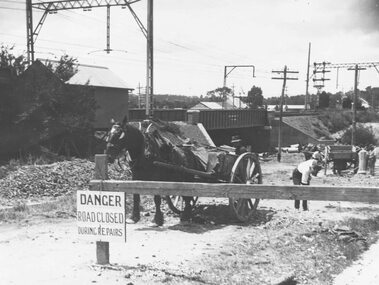
Photograph, Construction of railway viaduct in Pitt Street, Ringwood - circa 1923, south side looking east
... Construction of railway viaduct in Pitt Street, Ringwood - circa 1923, south side looking east...Black and White photograph (2 copies) Construction of railway viaduct in Pitt Street, Ringwood - circa 1923, south side looking east Photograph ...Black and White photograph (2 copies)Type below one copy: "Making Warrandyte Rd Subway, 1923 Taken from Pitt St." -
 Ringwood and District Historical Society
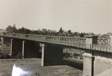
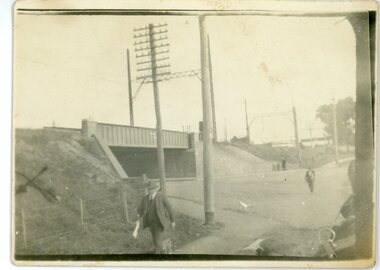
Photograph, Warrandyte Road Railway Viaduct . Ringwood 1924
... Warrandyte Road Railway Viaduct . Ringwood 1924..."Written on back of photograph" The new viaduct looking Westward toward Ringwood Railway Station. 10/5/1924 See also photograph mhc096 in NWD 02-09-06, showing costruction of viaduct in 1923....Sepia photograph Warrandyte Road Railway Viaduct . Ringwood 1924 Photograph ...Sepia photograph"Written on back of photograph" The new viaduct looking Westward toward Ringwood Railway Station. 10/5/1924 See also photograph mhc096 in NWD 02-09-06, showing costruction of viaduct in 1923. -
 Malmsbury Historical Society
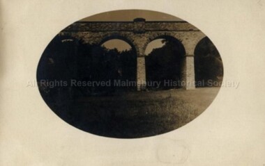
Postcard (Item), Railway Viaduct Over Coliban River At Malmsbury, Malmsbury ca1940
... Railway Viaduct Over Coliban River At Malmsbury, Malmsbury ca1940...Malmsbury Historical Society Malmsbury Mechanics Institute 71 Mollison Street Malmsbury daylesford-and-the-macedon-ranges Buildings - Coliban River & Malmsbury Mill Railway Viaduct Over Coliban River At Malmsbury, Malmsbury ca1940 Postcard Postcard ...Buildings - Coliban River & Malmsbury Mill -
 Sunshine and District Historical Society Incorporated
Document - Railway Viaducts Construction Albion to Broadmeadows Line
... Railway Viaducts Construction Albion to Broadmeadows Line...Two publication extracts and refering to the construction of the Albion and Glenroy viaduct bridges for the rail line from Broadmeadows through Sunshine to Tottenham which commenced in 1927 1 Railway Viaducts on the Albion to Broadmeadows Line by Wilfred Dinsey Chapman 2 Bridge Building in Exelsis by Chas H Perrin,Chief Engineer for Railway Construction...Railway Albion Glenroy Two publication extracts and refering to the construction of the Albion and Glenroy viaduct bridges for the rail line from Broadmeadows through Sunshine to Tottenham which commenced in 1927 1 Railway Viaducts on the Albion to Broadmeadows Line by Wilfred Dinsey Chapman 2 Bridge Building in Exelsis by Chas H Perrin,Chief Engineer for Railway Construction Railway Viaducts Construction Albion to Broadmeadows Line Document Railway Viaducts Construction Albion to Broadmeadows Line ...Two publication extracts and refering to the construction of the Albion and Glenroy viaduct bridges for the rail line from Broadmeadows through Sunshine to Tottenham which commenced in 1927 1 Railway Viaducts on the Albion to Broadmeadows Line by Wilfred Dinsey Chapman 2 Bridge Building in Exelsis by Chas H Perrin,Chief Engineer for Railway Constructionrailway, albion, glenroy -
 Kew Historical Society Inc
Photograph, Chandler Highway Bridge, 1930s
... outer circle railway...viaduct...The railway viaduct linking the Outer Circle railway from Kew to Fairfield was constructed in the 1890s. ...Kew Historical Society Inc Kew Court House 188 High Street Kew melbourne The railway viaduct linking the Outer Circle railway from Kew to Fairfield was constructed in the 1890s. ...The railway viaduct linking the Outer Circle railway from Kew to Fairfield was constructed in the 1890s. In the 1930s it was converted into a motorway bridge.Photocopy of a photograph of the bridge linking Kew and Fairfield. Dated to the 1930s following the construction off the Chanler Highway.outer circle railway, viaduct (kew fairfield), john monash, chandler highway bridge -
 Orbost & District Historical Society
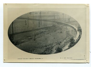
black and white photograph, Vogt. W.S, first half 20th century
... newmerella orbost-viaduct east-gipsland-railway...The two bridges on the railway viaduct, which crosses the Snowy River floodplain at Orbost, were built from local Southern Mahogany. ...It is of the railway viaduct across the flats at Orbost,....The two bridges on the railway viaduct, which crosses the Snowy River floodplain at Orbost, were built from local Southern Mahogany. ...In 1912 work was underrway on the Bairnsdale to Orbost railway. It was opened on April 10 1916. The two bridges on the railway viaduct, which crosses the Snowy River floodplain at Orbost, were built from local Southern Mahogany. The bridge on the Bairnsdale end (770m) is now the longest in Victoria. (info. Helen Martin)This item is associated with the history of the Orbost-Bairnsdale railway line and therefore reflects the role that the rail line played in the social and economic history of Orbost.A black / white photograph, oval-shaped on white background. It is of the railway viaduct across the flats at Orbost,.photo caption -"ORBOST RAILWAY BRIDGE, NEWMERELLA E. S. Vogt, Bairnsdale"newmerella orbost-viaduct east-gipsland-railway -
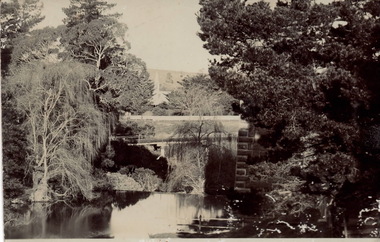
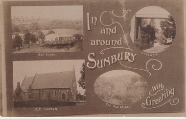 Sunbury Family History and Heritage Society Inc.
Postcard, In and around Sunbury with Greeting
... ...Railway viaduct...Carmel Catholic Church, the former old mill by Jacksons Creek and the railway viaduct and bridge at Rupertswood. ...Ben Eadie Winery Our Lady of Mount Carmel Catholic Church Railway viaduct The old mill Sunbury Post Cards A post card featuring a collage of four sepia views of Sunbury. ...The post card is one of a set of commercial cards produced for Sunbury. Each card featured particular buildings or places of interest in the town. This card included Ben Eadie winery, Our Lady of Mt. Carmel Catholic Church, the former old mill by Jacksons Creek and the railway viaduct and bridge at Rupertswood. All the buildings featured on the card are of historical significance to Sunbury's early development.A post card featuring a collage of four sepia views of Sunbury. The following greeting is written on the card: In and around Sunbury with Greeting. ben eadie winery, our lady of mount carmel catholic church, railway viaduct, the old mill, sunbury, post cards -
 Kew Historical Society Inc
Photograph, J F C Farquhar, Railway Bridge Over the Yarra, 1891
... ...railway viaduct - - kew (vic)...Completed in November 1890, the railway viaduct (now the Chandler Highway Bridge) linked Kew and Fairfield. ...The individual images have proved essential in identifying buildings and places of heritage value in the district. kew illustrated kew where we live photographic books henry kellett railway viaduct - - kew (vic) Railway Bridge Over the Yarra Completed in November 1890, the railway viaduct (now the Chandler Highway Bridge) linked Kew and Fairfield. ...At the beginning of the 1890s, the Kew businessman and Town Councillor, Henry Kellett, commissioned J.F.C. Farquhar to photograph scenes of Kew. These scenes included panoramas as well as pastoral scenes. The resulting set of twelve photographs was assembled in an album, Kew Where We Live, from which customers could select images for purchase.The preamble to the album describes that the photographs used the ‘argentic bromide’ process, now more commonly known as the gelatine silver process. This form of dry plate photography allowed for the negatives to be kept for weeks before processing, hence its value in landscape photography. The resulting images were considered to be finely grained and everlasting. Evidence of the success of Henry Kellett’s venture can be seen today, in that some of the photographs are held in national collections.It is believed that the Kew Historical Society’s copy of the Kellett album is unique and that the photographs in the book were the first copies taken from the original plates. It is the first and most important series of images produced about Kew. The individual images have proved essential in identifying buildings and places of heritage value in the district.Completed in November 1890, the railway viaduct (now the Chandler Highway Bridge) linked Kew and Fairfield. The viaduct is significant as the most substantial extant engineering remnant of the Outer Circle Railway Line. Opened in March 1891, the viaduct crossed the Yarra River in a single span, atop three supporting brick pillars. Following the closure of the railway line in 1927, and the construction of the Chandler Highway in 1930, the bridge was used for vehicular traffic. In 1891 when this panoramic photograph was taken, the grounds of what was then the Kew Lunatic Asylum extended down to the River and eastward beyond the viaduct. The landscape surrounding the Asylum was planted with traditional exotic trees such as Oaks, Pines and Cedars, and landmark trees from northern Australia such as the Hoop Pine. Remnant indigenous trees such as the River Red Gum, Yellow Box and Lightwood were scattered around the site, including beside the Yarra River.Railway Bridge Over the Yarrakew illustrated, kew where we live, photographic books, henry kellett, railway viaduct - - kew (vic) -
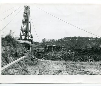 Orbost & District Historical Society
black and white photographs, 15th February 1971
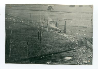
... Orbost-flood-1971 Orbost-viaduct-flood-damage Orbost-railway...Three black / white photographs of flood debris and flood waters near a railway line. 3102.l has a pile driver 3102.2 shows a gap in the viaduct and 3102.3 shows men with a tractor cleaning up the debris,...3102.1 - on back - "1971 FLOOD REPAIRS TO ORBOST RAILWAY VIADUCT - 15th February 1971. Donated by Audrey Van Den Berg VRH 3693" 3102.2 - on back - " DAMAGE TO RAILWAY VIADUCT ACCUMULATED DEBRIS" 3102.3 - on back - "DAMAGE TO RAILWAY VIADUCT AT ORBOST. ...Donated by Audrey Van Den Berg VRH 3693" 3102.2 - on back - " DAMAGE TO RAILWAY VIADUCT ACCUMULATED DEBRIS" 3102.3 - on back - "DAMAGE TO RAILWAY VIADUCT AT ORBOST. ...The 1971 flood was the the worst flood on record. At Jarrahmond it was at least 11 metres and up to one and a half kilometres wide on the flats causing enormous damage to the flood plain. Records say that "The brown floodwater stain in Bass Strait could be seen from passing airliners." Considerable damage was done to railway infrastructure, roads and farms. More information from the APRIL, 2008 newsletter by John Phillips. (see orbosthistory.com.au) The railway line was destroyed and was not expected to be opened for a fortnight. Orbost was cut off by 50 square miles of Snowy River floodwater. These photographs are pictorial records of the 1971 floods which was a significant event in the history of Orbost. They are also associated with the East Gippsland Railway.Three black / white photographs of flood debris and flood waters near a railway line. 3102.l has a pile driver 3102.2 shows a gap in the viaduct and 3102.3 shows men with a tractor cleaning up the debris,3102.1 - on back - "1971 FLOOD REPAIRS TO ORBOST RAILWAY VIADUCT - 15th February 1971. Donated by Audrey Van Den Berg VRH 3693" 3102.2 - on back - " DAMAGE TO RAILWAY VIADUCT ACCUMULATED DEBRIS" 3102.3 - on back - "DAMAGE TO RAILWAY VIADUCT AT ORBOST. CLEAN UP BEGINS"orbost-flood-1971 orbost-viaduct-flood-damage orbost-railway -
 Whitehorse Historical Society Inc.
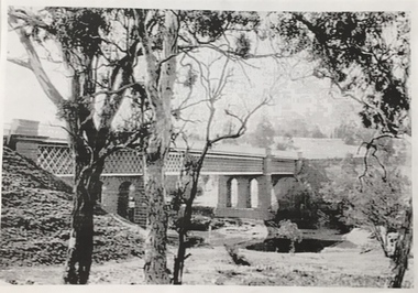
Document, Laburnum viaduct, 2006
... Photo of Laburnum railway viaduct and 'Toot Toot' sign before road straightening....Photo of Laburnum railway viaduct and 'Toot Toot' sign before road straightening. ...Photo of Laburnum railway viaduct and 'Toot Toot' sign before road straightening.Photo of Laburnum railway viaduct and 'Toot Toot' sign before road straightening.Photo of Laburnum railway viaduct and 'Toot Toot' sign before road straightening.laburnum street, blackburn, champion, isaac, railway bridges -
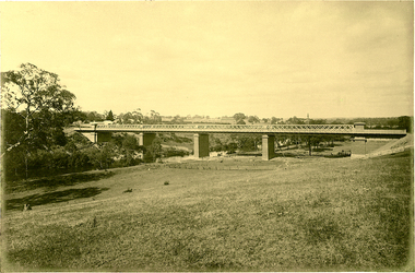
 Sunbury Family History and Heritage Society Inc.
Postcard
... ...Railway Viaduct Bridge...Rupertswood Mansion Jacksons Creek Railway Viaduct Bridge Bendigo Rail Line Railway viaduct Sunbury A non-digital black and white photograph in postcard format of a bridge spanning a waterway with tall trees on either side. ...The photograph was taken in the grounds of Rupertswood, William Clarke's country mansion. The waterway is the Jackson Creek and the bridge spanning the creek is one of four along the Sunbury - Bendigo railway line. Rupertswood Mansion is visible in the distance.A non-digital black and white photograph in postcard format of a bridge spanning a waterway with tall trees on either side. The tall tower of a building is visible in the distance. The sender, Bridget, who was at Rupertswood, has written a note on the back to Hal Eadie in Dannevirke in NZ. It is not possible to read the message because at some stage some brown paper was pasted on the card.rupertswood mansion, jacksons creek, railway viaduct bridge, bendigo rail line, railway viaduct, sunbury -
 Kew Historical Society Inc
Photograph, Outer Circle Railway Bridge over River Yarra, c.1900
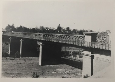
... Black & white photograph of the railway viaduct over Yarra River looking south towards Kew....Black & white photograph of the railway viaduct over Yarra River looking south towards Kew. ...This photograph forms part of the Eric Sibly collection of images and information relating to the Outer Circle Railway which he donated to the Kew Historical Society in 1974. Heritage Victoria Citation (Abridged) "The Chandler Highway Bridge, a 137 metre wrought iron lattice-truss girder bridge with four spans supported on red brick piers with moulded bluestone cappings. The bridge has a cantilevered walkway along the west side. ...The Chandler Highway Bridge crosses the Yarra River and connects Alphington and Kew. It was completed in November 1890 as part of the Outer Circle Railway Line.Black & white photograph of the railway viaduct over Yarra River looking south towards Kew.Reverse: "Pre 1930. Outer Circle Railway Bridge over River Yarra (now Chandler Highway) - note bridge over line on Kew side for Asylum Farm". KH - 56. Kew Historical Society.chandler highway, railway bridges - kew (vic), sir john monash, outer circle railway, river yarra - kew (vic) -
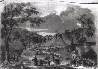
 Orbost & District Historical Society
black and white photograph, 1916
... orbost-railway east-gippsland-railway viaduct-orbost transport railway...This photograph shows the pile drivers at work in the construction of the viaduct across the Snowy River flats. The Snowy River Floodplain Railway Bridges, two sequential and exceptionally long and low timber railway bridges on the Snowy River floodplain just west of Orbost, were built in 1916, and provided the original terminus point for the Bairnsdale-Orbost railway. ...(information from Victorian Heritage Database) This item is associated with the history of the Orbost-Bairnsdale railway line and therefore reflects the role that the rail line played in the social and economic history of Orbost. orbost-railway east-gippsland-railway viaduct-orbost transport railway A black / white photograph of the farming flats at Orbost during the construction of the East Gippsland railway. black and white photograph ...This photograph shows the pile drivers at work in the construction of the viaduct across the Snowy River flats. The Snowy River Floodplain Railway Bridges, two sequential and exceptionally long and low timber railway bridges on the Snowy River floodplain just west of Orbost, were built in 1916, and provided the original terminus point for the Bairnsdale-Orbost railway. The bridges are 770 metres and 183 metres long respectively. The shorter bridge is of uniformly 4.57 metre timber-beam construction, and has a sweeping curve in its deck. The longer bridge has a combination of 4.57 metre and 6.1 metrespans, and two 3.66 metre spans. The bridges are constructed from 'Southern Mahogany', Eucalyptus Botryoides, which grew along the coast east of Bairnsdale. The Snowy floodplain bridges were initially built in the context of an early twentieth-century interest in American-style 'Developmental Railways', designed to open remote areas to closer settlement, even if that meant running at a loss. The line was closed in August 1987. (information from Victorian Heritage Database)This item is associated with the history of the Orbost-Bairnsdale railway line and therefore reflects the role that the rail line played in the social and economic history of Orbost.A black / white photograph of the farming flats at Orbost during the construction of the East Gippsland railway.orbost-railway east-gippsland-railway viaduct-orbost transport railway -
Federation University Historical Collection
Book, Historic Sites Survey: North Central Study Area, 1979, 1979
... ...taradale railway viaduct...Barker Library (top floor) Mount Helen goldfields The North Central Study Area included the Shires of Avoca, Bet Bet, east Loddon, Goulburn, Untly, Kara Kara, Korong, Maldon, Marong, Metcalfe, McIvor, Newstead, Strathfieldsaye, Stawell, Talbot, Clunes, Tullaroop and Waranga. castlemaine mount alexander goldfield maldon percydale warrenmang moliagul tarnagulla stuart mill the whipstick whroo rushworth graytown ironbark forest st arnoaud new bendigo landsborough inglewood kurting wedderburn wehla kooroora langham flat mcintyre rheola diamond hill fosterville coliban water works green gully newstead muckleford forest costerfield graytown bailieston waranga irrigaiton system eucalyptus distillery mia mia bridge korokubeal township researce concegella slate quarry chewton fryerstown kingower timor talbot majorca carisbroook clunes st arnaud taradale icomos dunolly limestone castlemaine slate quarry harcourt granite taradale railway viaduct loddon united waterworks trust gouldburn weir carisbrook lock-up history of tree planting in streets history of public reserves r.u. nicholls nurseryman thomas lang francis moss ballarat botanical gardens ballarat school of mines botanical gardens lake wendouree victoria park, ballarat muont holled smith ballaarat old cemetery planting eastern oval ballarat east botanical gardens ballarat east town hall gardens eureka stockade reserve ballarat observatory plantings yarrowee creek plantings yarrowee bluestone channels ballarat woollen mill band and albion mullock heap black hill plantings yarrowee creek channels canadian creek channel specimen vale channel poverty point reserve union jack reserve buninyong imperial mine, buninyong victoria street plantings bridge mall sturt street gardens ballarat avenue of honour plantings white flat oval plantings camp street elms burnt creek 153 page book with white plastic binding. ...The North Central Study Area included the Shires of Avoca, Bet Bet, east Loddon, Goulburn, Untly, Kara Kara, Korong, Maldon, Marong, Metcalfe, McIvor, Newstead, Strathfieldsaye, Stawell, Talbot, Clunes, Tullaroop and Waranga. 153 page book with white plastic binding. It is an historic sites survey for the North Central Study Area commissioned by the Land Conservation Council, the Ministry for COnservation and the Australian Heritage Commission. castlemaine, mount alexander goldfield, maldon, percydale, warrenmang, moliagul, tarnagulla, stuart mill, the whipstick, whroo, rushworth, graytown ironbark forest, st arnoaud, new bendigo, landsborough, inglewood, kurting, wedderburn, wehla, kooroora, langham flat, mcintyre, rheola, diamond hill, fosterville, coliban water works, green gully, newstead, muckleford forest, costerfield, graytown, bailieston, waranga irrigaiton system, eucalyptus distillery, mia mia bridge, korokubeal township researce, concegella slate quarry, chewton, fryerstown, kingower, timor, talbot, majorca, carisbroook, clunes, st arnaud, taradale, icomos, dunolly, limestone, castlemaine slate quarry, harcourt granite, taradale railway viaduct, loddon united waterworks trust, gouldburn weir, carisbrook lock-up, history of tree planting in streets, history of public reserves, r.u. nicholls nurseryman, thomas lang, francis moss, ballarat botanical gardens, ballarat school of mines botanical gardens, lake wendouree, victoria park, ballarat, muont holled smith, ballaarat old cemetery planting, eastern oval, ballarat east botanical gardens, ballarat east town hall gardens, eureka stockade reserve, ballarat observatory plantings, yarrowee creek plantings, yarrowee bluestone channels, ballarat woollen mill, band and albion mullock heap, black hill plantings, yarrowee creek channels, canadian creek channel, specimen vale channel, poverty point reserve, union jack reserve buninyong, imperial mine, buninyong, victoria street plantings, bridge mall, sturt street gardens, ballarat avenue of honour plantings, white flat oval plantings, camp street, elms, burnt creek -
![Photographs [Series], Noel Kelly, Chandler Highway Bridge Construction, 11/07/2018](/media/collectors/550653872162f11fb04854aa/items/5c2f52bd21ea670d20783d9e/item-media/5c2f53b221ea670d2079233e/item-fit-380x285.jpg?cb=6) Kew Historical Society Inc
Kew Historical Society IncPhotographs [Series], Noel Kelly, Chandler Highway Bridge Construction, 11/07/2018
... ...railway viaduct - river yarra...Kew Historical Society Inc Kew Court House 188 High Street Kew melbourne chandler highway bridge noel kelly railway viaduct - river yarra A selection of photographs taken in July/August 2018 recording work on the old and new Chandler Highway Bridges. ...A selection of photographs taken in July/August 2018 recording work on the old and new Chandler Highway Bridges.chandler highway bridge, noel kelly, railway viaduct - river yarra