Showing 14 items matching "recreation -- river swimming"
-
 Kew Historical Society Inc
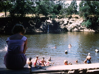
Photograph - Swimming in the Yarra River, Ron Setford, 1960-61
... ...Recreation -- river swimming....) -- 1960s Yarra River Recreation -- river swimming Nil Photograph Swimming in the Yarra River Ron Setford ...Ron Setford and his wife Grace Setford lived in Tanner Avenue, East Kew, from c.1946 to c.1995. A keen photographer, he recorded the changing face of Kew over a 20 year period. Apart from 30 photographs of built structures and places in Kew dating from 1960 and 1961, 145 of his 35mm colour slides chronicle the development of the Eastern Freeway through the Yarra Valley over a five year period from c.1972 to c.1977. This important collection was donated to the Society by his granddaughter in 2025.This collection of 175 35mm slides is of local and statewide significance, owing to its subject matter, particularly the major development of road transport infrastructure during the 1970s with the construction of the Eastern Freeway. The photographer also took care to annotate and date most of his slides which enable the researcher to pinpoint temporal and spatial locations.Nilron setford, photographs -- kew (vic.) -- 1960s, yarra river, recreation -- river swimming -
 Warrnambool and District Historical Society Inc.
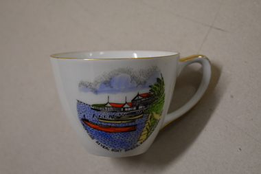
Cuo, Westminster China Australia, Hopkins River Boat, Mid 20th century
... swimming and hot and cold seawater baths. Today tourists come in winter to see the Southern Right whales at Logans Beach and in summer they come for a beach holiday. The Hopkins River is a popular recreation...swimming and hot and cold seawater baths. Today tourists come in winter to see the Southern Right whales at Logans Beach and in summer they come for a beach holiday. The Hopkins River is a popular recreation ...Tourism has been an important industry in Warrnambool for over 100 years. In the late 19th century Warrnambool was promoted as a spa resort offering a mild climate, seaside swimming and hot and cold seawater baths. Today tourists come in winter to see the Southern Right whales at Logans Beach and in summer they come for a beach holiday. The Hopkins River is a popular recreation destination with boating, fishing and water skiing. The Proudfoots Boathouse was established in 1885 by Thomas Proudfoot. This cup is an interesting example of a Warrnambool tourist souvenir from the mid to late 20th century.This is a small white china cup. There is gold edging around the rim and on the handle. On the side of the cup is a coloured image of Proudfoots Boatsheds at the mouth of the Hopkins River in Warrnambool. Hopkins River Boatsheds Warrnambool Fine China Westminster China Australia tourism in warrnambool, history of warrnambool -
 Orbost & District Historical Society
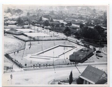
black and white photographs, 1980s? (winter months)
... The swimming pool and bowling club can be seen in the foreground. 3259.2 is aview looking north-west and showing the tennis courts and clubhouse, the Recreation Reserve oval, the Youth Centre, Historical Museum, Municipal Offices, Senior Citizens clubrooms with the fire station in the foreground. 3259.3 is a view looking south with the Shire of Orbost Municipal offices and Ruskin Street in the foreground. Munro Street can be seen running from Ruskin Street to St Joseph's School in the middle distance. Lochiel Park oval, Lochiel House, the Snowy River...The swimming pool and bowling club can be seen in the foreground. 3259.2 is aview looking north-west and showing the tennis courts and clubhouse, the Recreation Reserve oval, the Youth Centre, Historical Museum, Municipal Offices, Senior Citizens clubrooms with the fire station in the foreground. 3259.3 is a view looking south with the Shire of Orbost Municipal offices and Ruskin Street in the foreground. Munro Street can be seen running from Ruskin Street to St Joseph's School in the middle distance. Lochiel Park oval, Lochiel House, the Snowy River ...All photographs seem to have been takenfrom the Telecom tower on the corner of Browning and Wolseley Streets in Orbost 3259.1 is a view of the Orbost township looking north-east. The swimming pool and bowling club can be seen in the foreground. 3259.2 is aview looking north-west and showing the tennis courts and clubhouse, the Recreation Reserve oval, the Youth Centre, Historical Museum, Municipal Offices, Senior Citizens clubrooms with the fire station in the foreground. 3259.3 is a view looking south with the Shire of Orbost Municipal offices and Ruskin Street in the foreground. Munro Street can be seen running from Ruskin Street to St Joseph's School in the middle distance. Lochiel Park oval, Lochiel House, the Snowy River and highway bridge are in the background. 3259.4 is a view looking south showing the Club Hotel, C.B.C. Bank in the middle distance and Hoffman's paddock (Forest Park) and the Snowy River beyond. 3259.5 is a view looking north-east over houses. 3259.6 is aview over the main street, Nicholson Street.showing the main shopping precinct. Shop signs for Permewans, Williams Shoes, F.B. Dicken and Orbost Bakery can be seen. 3259.7 is a view looking south west and shows Forest park and beyond towards Bete Bolong.These photographs are detailed pictorial records of the township of Orbost.Seven black / white photographs taken from above a township. Chimney smoke can be seen in the photographs.orbost-township-1980s aerial-photograph-orbost -
 Flagstaff Hill Maritime Museum and Village
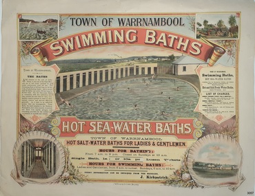
Poster - Recreation, Town of Warrnambool Swimming Baths, ca. May 1884
... Swimming Baths. It has several drawings such as Middle Island and the Merri River Mouth with vessels in the water, The inside of the Baths facility, the men's baths with the adjacent bathing rooms and figures in and out of the water, a cottage with figures in the garden, and fenced buildings with a windmill and aqueduct or pipes. The text describes the location and advantages, the opening times and various costs. It was printed in Ballarat by F.W. Niven & Co. Lithos. Town of Warrnambool Swimming Baths Poster Recreation ...The poster advertises these Swimming Baths as “the most complete in the Southern Hemisphere”. In February 1877 a Baths Company (1050 shares) was formed in the town of Warrnambool for the establishment of the baths at the south end of Gillies Street. The baths were filled with sea water from Lady Bay, originally pumped by a windmill situated near the current Surf Lifesaving Club and carried by iron pipes to the Public Baths; later the water was pumped by a gas motor. Hot and cold fresh water baths were advertised. The gentlemen’s bath was 100 feet long and 50 feet wide, of graduating depth. A second bath, solely for ladies, was 60 feet long by 30 feet wide. Hot Sea water Baths were also part of the institution, and were sought after for their ‘wonderful curative powers’, and ‘incomparable’ as a ‘tonic for the feeble’. In June 1881 the Hot Sea Baths were opened, and both hot and cold water baths were supplied at reasonable charges. Patrons came from near and far to receive the benefits. The manager of the Baths was J. Kirkpatrick. The Baths Company struggled for several years without success, so in 1883 the baths were sold to the Borough Council for 1250 pounds. The original shareholders received nothing for their outlay; the overdraught was over the sale price. In May 1884 the Council announced that an estimated they has spent 1000 pounds in improving the baths since purchasing them and were now returning an income of 11 per cent. Historically significant to Warrnambool and the recreational facilities available in the 1880s to 1900s. The remains of the baths are still visible to the public today.Poster on heavy cream paper, landscape orientation, with coloured print. The poster advertises the Warrnambool Swimming Baths. It has several drawings such as Middle Island and the Merri River Mouth with vessels in the water, The inside of the Baths facility, the men's baths with the adjacent bathing rooms and figures in and out of the water, a cottage with figures in the garden, and fenced buildings with a windmill and aqueduct or pipes. The text describes the location and advantages, the opening times and various costs. It was printed in Ballarat by F.W. Niven & Co. Lithos."TOWN OF WARRNAMBOOL" "SWIMMING BATHS" "HOT SALT-WATER BATHS FOR LADIES AND GENTLEMEN" "HOURS FOR BATHING fROM 7 a.m. to 9 p. m. Closed on Sundays at 10 a.m." Single Bath 1s [1 shilling]; or 10s per Dozen Tickets" "HOURS FOR SWIMMING BATHS: Ladies and Gentlemen, from 6 a.m. to Sunset, Sundays 6 a.m. to 10 a.m." "Every information can be obtained from the Manager, J. Kirkpatrick" "HOT SEA-WATER BATHS ... strongly recommended by the Medical Faculty" "Hot and Cold Fresh Water Baths" "Showers etc." "LIST OF CHARGES ... Single Season Ticket, Single Monthly Ticket, Single Bath without towel ... with towel.. Tickets per dozen without towel, with towel..." "The Baths are situated at the end of Gillies Street, in the rear of the Post Office, and are of salt water pumped by gas motor continuously from the sea. The Swimming Bath is 100 feet long by 50 feet wide, of graduating depth; and a second bath for ladies' use solely, 60 feet long by 30 feet wide. The hot Sea-water Baths in connection with this institution have been extolled far and wide for their wonderfully curative powers in cases of rheumatism, sciatica, and nervous afflictions generally. As a tonic to an enfeebled system, they are incomparable, These Baths, the most complete in the Southern Hemisphere, have been recently re-erected and fitted with marble plunges, and everything provided for the comfort and convenience of invalids and visitors." "F.W. NIVEN & Co, LITHOS, BALLARAT"flagstaff hill, warrnambool, warrnambool swimming baths, hot sea water baths warrnambool, warrnambool baths company, f.w. niven & co, warrnambool therapudic baths, town of warrnambool, swimming baths, hot sea water baths, salt water baths, ladies' baths, gentlemen's baths, warrnambool town baths, j kirkpatrick -
 Marysville & District Historical Society
Ephemera (Item) - Information brochure, Artworkz Tourism, MARYSVILLE THINGS TO DO AROUND MARYSVILLE, 27-01-2018
... river...bruno's art and sculpture garden...fernshaw park...buxton recreation reserve...taggerty river areas...anderson mill camping area...cooks mill camping area...neds gully camping area...keppel creek day area...beauty spot nature walk...gilbert gully nature walk...michaeldene track...cathedral range...the beeches walk...tree fern gully walk...crystal journey...marysville market...lake mountain ski resort...marysville golf club...marysville public outdoor swimming...An information brochure on things to do around Marysville in Victoria. marysville victoria australia information brochure gallipoli park lake gallipoli lake steavenson falls steavenson river bruno's art and sculpture garden fernshaw park buxton recreation reserve taggerty river areas anderson mill camping area cooks mill camping area neds gully camping area keppel creek day area beauty spot nature walk gilbert gully nature walk michaeldene track cathedral range the beeches walk tree fern gully walk crystal journey marysville market lake mountain ski resort marysville golf club marysville public outdoor swimming pool buxton trout & salmon farm keppel's lookout jock's lookout mount gordon armstrong lookout keppel falls phantom falls cora lynn falls meeting of the waters st ronan's well preiffer falls camberville historical township keppels hut the big culvert the big tree marysville historical society Disclaimer: The authors have taken care to ensure this/ publication is correct, though please be aware that/ errors and omissions do occur. ...An information brochure on things to do around Marysville in Victoria.An information brochure on things to do around Marysville in Victoria.Disclaimer: The authors have taken care to ensure this/ publication is correct, though please be aware that/ errors and omissions do occur.marysville, victoria, australia, information brochure, gallipoli park lake, gallipoli lake, steavenson falls, steavenson river, bruno's art and sculpture garden, fernshaw park, buxton recreation reserve, taggerty river areas, anderson mill camping area, cooks mill camping area, neds gully camping area, keppel creek day area, beauty spot nature walk, gilbert gully nature walk, michaeldene track, cathedral range, the beeches walk, tree fern gully walk, crystal journey, marysville market, lake mountain ski resort, marysville golf club, marysville public outdoor swimming pool, buxton trout & salmon farm, keppel's lookout, jock's lookout, mount gordon, armstrong lookout, keppel falls, phantom falls, cora lynn falls, meeting of the waters, st ronan's well, preiffer falls, camberville historical township, keppels hut, the big culvert, the big tree, marysville historical society -
 Sunshine and District Historical Society Incorporated
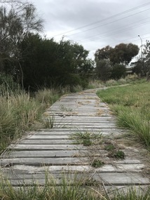
Photograph - Lions Club Reserve Kororoit Creek Deer Park Photographs, John Alchin, 2021
... swimming pools such as the ones located in Sunshine and St. Albans. Today, now an almost forgotten location in Deer Park, the water hole provides a tranquil location for visitors to relax and watch the creek slowly flowing past and the birdlife that frequent the area. Water holes along the Kororoit Creek and Maribyrnong River were once used for providing drinking water, relaxation, recreation ...No formal name has been assigned to this reserve. From research, which is still to be confirmed, it is believed the Deer Park Lions Club installed the infrastructure in the area, which includes the wooden path, table and bench seat, therefore for convenience we will refer to it as the Lions Club Reserve. Situated on the west bank of the Kororoit Creek, it lies directly opposite the Deer Park Hotel, where a swimming hole once enjoyed popularity among the early residents of Deer Park. Unfortunately, as the surrounding areas were developed for residential and industrial requirements, along came pollution that made these holes unsafe to swim in. The use of these holes were discouraged in the mid 1900's and subsequently the local Councils of the district started to provide man made swimming pools such as the ones located in Sunshine and St. Albans. Today, now an almost forgotten location in Deer Park, the water hole provides a tranquil location for visitors to relax and watch the creek slowly flowing past and the birdlife that frequent the area.Water holes along the Kororoit Creek and Maribyrnong River were once used for providing drinking water, relaxation, recreation sport and spots to cool off on the long summer days.5651.01 - Lions Club Reserve Kororoit Creek West Bank Deer Park 2021 Photo 23.JPG 5651.02 - Lions Club Reserve Kororoit Creek West Bank Deer Park 2021 Photo 17.JPG 5651.03 - Lions Club Reserve Kororoit Creek West Bank Deer Park 2021 Photo 19.JPG 5651.04 - Lions Club Reserve Kororoit Creek West Bank Deer Park 2021 Photo 20.JPG 5651.05 - Lions Club Reserve Kororoit Creek West Bank Deer Park 2021 Photo 21.JPG ballarat road, deer park, kororoit creek, deer park lions club -
 Orbost & District Historical Society
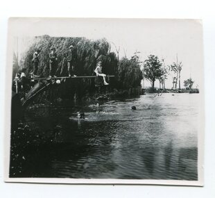
Photograph, 1920s-1950s
... swimming...Snowy River...recreation...From the earliest days of white settlement in the Orbost district, people used the Snowy River for recreation and transport. A local swimming hole was adjacent to the butter factory and was a deep hole. ...The 50 metres swimming pool was constructed in the 1960s following a huge community campaign. This photo is significant because it shows the use of the Snowy River as a recreation resource prior to the construction of a community swimming pool. swimming Snowy River recreation This is 'THE BIG HOLE' on the Snowy just beyond the butter factory. ...From the earliest days of white settlement in the Orbost district, people used the Snowy River for recreation and transport. A local swimming hole was adjacent to the butter factory and was a deep hole. The diving board has been improvised. This photo appears to date from c.1920-1940s. The 50 metres swimming pool was constructed in the 1960s following a huge community campaign. This photo is significant because it shows the use of the Snowy River as a recreation resource prior to the construction of a community swimming pool. A b/w photo of a group of children, three swimming and five on a diving board. One at the end of the diving board has a swimming costume, others are fully dressed. This is 'THE BIG HOLE' on the Snowy just beyond the butter factory. Water about 8ft. deep straight off the bank. We were all very good swimmers and played there for hours and hours."swimming, snowy river, recreation -
 Hume City Civic Collection
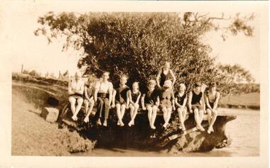
Photograph
... Sunbury Swimming Pool - written on the back. swimming sports jackson's creek clothing and dress recreation swimming pools sunbury swimming pool george evans collection A snap shot of 11 people (unidentified) sitting on the bank of a river. ...The area near the 'Nook' was used as a swimming pool by Sunbury residents before the swimming centre was built in Ligar Street, Sunbury. Sunbury Swimming Pool - written on the back.A snap shot of 11 people (unidentified) sitting on the bank of a river. There are two men and 9 children of varying ages in the photo.swimming, sports, jackson's creek, clothing and dress, recreation, swimming pools, sunbury swimming pool, george evans collection -
 Hume City Civic Collection
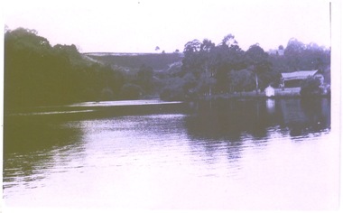
Photograph, The Nook, c1940
... recreation with a walking path along the Jacksons Creek. The house on the RHS of the photograph was situated near Powlett Street. Before the Aquatic Centre was built in Sunbury the swimming pool at The Nook was the town's swimming pool for many years. Seats and a change area were at the site. The Nook Swimming Jacksons Creek A black and white photograph of a large bend in a river ...The Nook in Sunbury is situated on a wide and deep bend in Jacksons Creek. Today the area is a popular site for passive recreation with a walking path along the Jacksons Creek. The house on the RHS of the photograph was situated near Powlett Street.Before the Aquatic Centre was built in Sunbury the swimming pool at The Nook was the town's swimming pool for many years. Seats and a change area were at the site.A black and white photograph of a large bend in a river with a house built on its riverbank and another dwelling on the hillside in the middle distance.the nook, swimming, jacksons creek -
 Kew Historical Society Inc
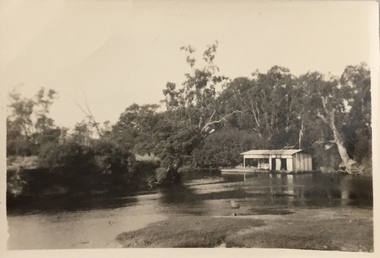
Photograph, Chipperfield's Boat House & Floating Pontoon, 1934
... recreation. Numerous photographs record flooding throughout the Twentieth Century. yarra river chipperfield's boathouse pontoon Floating pontoon at Chipperfield's Boat House where the canoes were stored, taken in 1934, presumably before the 1934 Flood. This area of the Yarra was shallow with a number of mid river sandbanks and a popular swimming ...Living with natural processes was frequently a challenge to early European settlers and later residents of what was in the 1850s administered by the Borondara Road Board. This was compounded by the area being bounded on three sides by rivers (Yarra River, Koonung Creek and Gardiner's Creek). In 1849, the historian James Bonwick recorded that "our district [Kew] suffered considerably. Mr Wade speaks of 80 acres, out of 100 acres of his cultivated paddock, covered by water." Newspapers continued to describe major flooding in Kew in 1863, 1869, 1878, 1880, 1889, 1891, 1916 and 1934. While the construction of the Upper Yarra dam in 1957 reduced the levels of flowing downstream, local and riverine floods continue. A number of boat houses operated on both sides of the River Yarra at Kew. Chipperfield's Boat House was located on the Yarra near the corner of Kilby and Willsmere Roads.The Kew Historical Society's pictures and map collections testify to the impact of flooding in the district. They have historical importance in documenting the extent of flooding in the district and its affects on homes, services and recreation. Numerous photographs record flooding throughout the Twentieth Century.Floating pontoon at Chipperfield's Boat House where the canoes were stored, taken in 1934, presumably before the 1934 Flood. This area of the Yarra was shallow with a number of mid river sandbanks and a popular swimming area for locals.yarra river, chipperfield's boathouse, pontoon -
 Kew Historical Society Inc
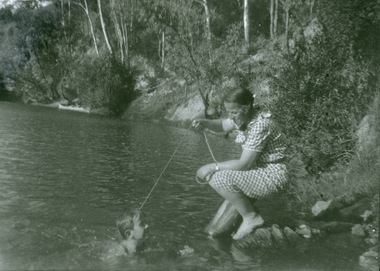
Photograph - Mother and child at the Yarra River, Kew, 1950s
... River Yarra was a recreational traditional pastime for the people of Kew and Melbourne since settlement in the 1830s. Later in the century, canoes were frequently hired from boathouses. Recreation -- Canoeing Yarra River -- Kew Reverse: "M Holmes" Print enlargement. Woman beside river holding a piece of string. Child swimming ...Canoeing on the River Yarra was a recreational traditional pastime for the people of Kew and Melbourne since settlement in the 1830s. Later in the century, canoes were frequently hired from boathouses.Print enlargement. Woman beside river holding a piece of string. Child swimming in Yarra. Canoe in distance beside bank with passengers.Reverse: "M Holmes"recreation -- canoeing, yarra river -- kew -
 Kew Historical Society Inc
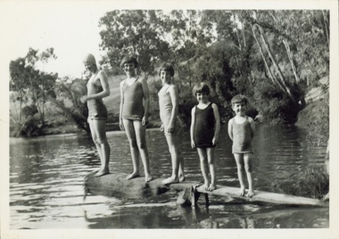
Photograph - Children on a diving platform on the Yarra at Kew, 1940s
... River Yarra...Recreation --- swimming...The River Yarra was a traditional place of recreation for children and adults in Kew. Often swimming in the Yarra was made from platforms attached to the bank such as this one....River Yarra Recreation --- swimming Reverse: "M Holmes" Original black and white photograph. ...The River Yarra was a traditional place of recreation for children and adults in Kew. Often swimming in the Yarra was made from platforms attached to the bank such as this one.Original black and white photograph. Group of five children in bathing costumes on a rudimentary diving board attached to the bank of the River Yarra.Reverse: "M Holmes"river yarra, recreation --- swimming -
 Kew Historical Society Inc
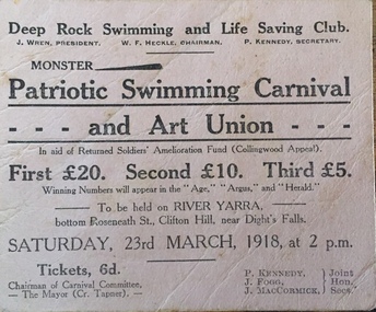
Flyer, Deep Rock Swimming and Lifesaving Club, Monster Patriotic Swimming Carnival and Art Union, 1918
... river yarra -- recreation...yarra - swimming...recreation on the Yarra River in Melbourne in the first half of the twentieth century. An item from a large collection assembled by the Christian and Washfold families of Kew, including photographs, postcards, and ephemera. Many of the items in the Christian-Washfold Collection relate to the Yarra River and its use as as a recreational resource. Numerous items in the collection are historically important in that they are rare and often unique records of vanished locations or past recreational activities. christian-washfold collection river yarra -- recreation yarra - swimming ...An item of ephemera relating to tourism and recreation on the Yarra River in Melbourne in the first half of the twentieth century.An item from a large collection assembled by the Christian and Washfold families of Kew, including photographs, postcards, and ephemera. Many of the items in the Christian-Washfold Collection relate to the Yarra River and its use as as a recreational resource. Numerous items in the collection are historically important in that they are rare and often unique records of vanished locations or past recreational activities.Advertisement or ticket to a Monster Swimming Carnival to be held by the Deep Rock Swimming and Lifesaving Club in Fairfield at the bottom of Roseneath Street on Saturday 23rd March 1918 at 2 p.m.christian-washfold collection, river yarra -- recreation, yarra - swimming carnivals, deep rock pool -
Marysville & District Historical Society
THE TRIANGLE NEWS-VOL 41 NO 41-OCTOBER 24 2014
... river valley holiday planner...mayor's chair by cr margaret rae...murrindindi shire council...councillor comment cr christine challen...emotions anonymous international meeting...marysville & triangle community men's shed...buxton recreation reserve committee...community working bee at buxton recreation reserve...melbourne cup day office closures...marysville district football & netball club agm...residential & rural real estate...marysville & triangle real estate...dalton fiske foundation...el kanah spring menu...social dance buxton hall...great victorian bike ride expressions of interest...street stall for christ church marysville...notice of public sale...swimming...marysville victoria australia open gardens featured in narbethong and buxton alexandra & district open gardens weekend what's on when in october the committee of management of the gallipoli park precinct marysville community market creative triangle marysville art show 2014 community centre cup weekend intrepid triangle bushwalkers marysville golf report church notices advertisements 2015 goulburn river valley holiday planner mayor's chair by cr margaret rae murrindindi shire council councillor comment cr christine challen emotions anonymous international meeting marysville & triangle community men's shed buxton recreation reserve committee community working bee at buxton recreation reserve melbourne cup day office closures marysville district football & netball club agm residential & rural real estate marysville & triangle real estate dalton fiske foundation el kanah spring menu social dance buxton hall great victorian bike ride expressions of interest street stall for christ church marysville notice of public sale swimming pool ticket pricing triangle community dinner tender operations shed assistant casual bus driver operations co ordinator buxton bootcamp nominate a local young achiever pink lunch pink ribbon day auction at buxton hall national breast cancer foundation barefoot bowls marysville community golf & bowls club meet the candidates for eildon the outdoor ed group THE TRIANGLE NEWS-VOL 41 NO 41-OCTOBER 24 2014 ...marysville, victoria, australia, open gardens featured in narbethong and buxton, alexandra & district open gardens weekend, what's on when in october, the committee of management of the gallipoli park precinct, marysville community market, creative triangle, marysville art show 2014, community centre cup weekend, intrepid triangle bushwalkers, marysville golf report, church notices, advertisements, 2015 goulburn river valley holiday planner, mayor's chair by cr margaret rae, murrindindi shire council, councillor comment cr christine challen, emotions anonymous international meeting, marysville & triangle community men's shed, buxton recreation reserve committee, community working bee at buxton recreation reserve, melbourne cup day office closures, marysville district football & netball club agm, residential & rural real estate, marysville & triangle real estate, dalton fiske foundation, el kanah spring menu, social dance buxton hall, great victorian bike ride expressions of interest, street stall for christ church marysville, notice of public sale, swimming pool ticket pricing, triangle community dinner, tender, operations shed assistant, casual bus driver, operations co ordinator, buxton bootcamp, nominate a local young achiever, pink lunch, pink ribbon day, auction at buxton hall, national breast cancer foundation, barefoot bowls, marysville community golf & bowls club, meet the candidates for eildon, the outdoor ed group