Showing 111 items matching "recreational use"
-
 Southern Sherbrooke Historical Society Inc.
book, "Lysterfield Lake Park, Proposed Recreation Use Plan", Jun-86
... A proposed plan for the recreational use of Lysterfield Lake Park....Southern Sherbrooke Historical Society Inc. 127 Colby Drive Belgrave Heights 3160 yarra-valley-and-the-dandenong-ranges lysterfield lake park A proposed plan for the recreational use of Lysterfield Lake Park. "Lysterfield Lake Park, Proposed Recreation Use Plan" book ...A proposed plan for the recreational use of Lysterfield Lake Park.lysterfield lake park -
 Surrey Hills Historical Society Collection
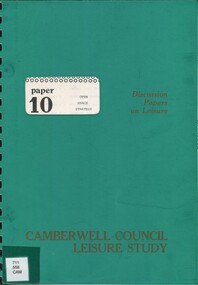
Book, Camberwell Council - Open Space Strategy: paper 10, 1982
... ...recreational use....; maps; This discussion paper only present draft policies, and are published in this form to obtain the opinions of the community, councillors, field-workers and experts. open spaces camberwell victoria recreational use 126p.; maps; This discussion paper only present draft policies, and are published in this form to obtain the opinions of the community, councillors, field-workers and experts. ...Series title: Camberwell Council Leisure study: discussion papers on leisure; 10 126p.; maps; This discussion paper only present draft policies, and are published in this form to obtain the opinions of the community, councillors, field-workers and experts.126p.; maps; This discussion paper only present draft policies, and are published in this form to obtain the opinions of the community, councillors, field-workers and experts.open spaces, camberwell, victoria, recreational use -
 City of Moorabbin Historical Society (Operating the Box Cottage Museum)
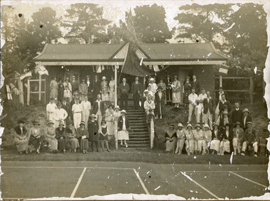
Photograph, black & white Cheltenham Tennis Club 1920, and 2 Documents, 1920
... Cheltenham Tennis Club was established 1883 when Shire of Moorabbin released land in Cheltenham Park for recreational use. 1924 The Shire of Moorabbin gave permission for the development of extra Courts....City of Moorabbin Historical Society (Operating the Box Cottage Museum) Joyce Park Jasper Road Ormond melbourne Cheltenham Tennis Club was established 1883 when Shire of Moorabbin released land in Cheltenham Park for recreational use. 1924 The Shire of Moorabbin gave permission for the development of extra Courts. ...Cheltenham Tennis Club was established 1883 when Shire of Moorabbin released land in Cheltenham Park for recreational use. 1924 The Shire of Moorabbin gave permission for the development of extra Courts.Cheltenham Tennis Club 1883 was one of the first Tennis Clubs established in Melbourne.A black and white photograph of men and women seated and standing in and around the Cheltenham Tennis Clubhouse in Cheltenham Park, Cheltenham in 1920. Letter Handwritten 1883 Shire of Moorabbin, South Brighton , release of land in Cheltenham Park for the development of Tennis Courts. Letter Typed 1924 Shire of Moorabbin, permission for extra Courts, signed by the shire secretary, Alexander Chalmers Smith.PHOTO ; written on back : Cheltenham Tennis Club 1920 / Cheltenham Park Letter ; signed John Keys Shire of Moorabbin South Brighton Logo 1871 Letter ; Shire of Moorabbin Logo 1924charman road, cheltenham, 1920, tennis club. charman stephen, gettens mary, spring grove, charman road, balcombe road, nepean road, dairy farmers, market agrdeners, poultry farmers, methodist church, keys john, shire of moorabbin, colsamix, cheltenham park melbourne, sabbath victorian law article 26, cheltenham golf club -
 Kiewa Valley Historical Society
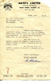
Photograph - Mt Beauty Community Centre original colour plan and photos of upgrade in 2000, 1. Dated March 22nd, 1962 2. Photographs taken during renovations in 2000
... The Community Centre was built in the early 1950’s as an all-purpose hall for the social and recreational use of the workers and families employed on the Victorian state government Kiewa Hydro-electric scheme. ...Kiewa Valley Historical Society Mount Beauty Information Centre 31 Bogong High Plains Rd Mt Beauty high-country The Community Centre was built in the early 1950’s as an all-purpose hall for the social and recreational use of the workers and families employed on the Victorian state government Kiewa Hydro-electric scheme. ...The Community Centre was built in the early 1950’s as an all-purpose hall for the social and recreational use of the workers and families employed on the Victorian state government Kiewa Hydro-electric scheme. The hall was originally called Mt Beauty Recreation Centre and later changed to Mt Beauty Community Centre. It has been the heart of the community for over 65 years and had a heritage listing put on it around the year 2000. The Alpine Shire secured a heritage grant and the hall was restored to its former glory in 2000. In heritage circles it is claimed that the hall is the best example of a 1950’s construction town community hall, which is still functioning anywhere in AustraliaThe Community Centre was and is a very important part of life in the small remote community of Mount Beauty and a range of activities have taken place in the Community Centre over the past 65 years- Picture theatre; Dances and balls; A physical education and boxing club run by Alex McCollough for 30 years; School and social club concerts; Girls gymnastics; Drama group productions, revues and pantomimes; Callisthetics and ballet; Badminton; Wedding receptions and birthday parties; Music festival events; Staging area in times of natural disaster; The library for many years; Shire and community meetings; Secondary College gymnasium for many years and shelter for the Community Market in inclement weather 1 – 1972 specifications for colour scheme of original Mt Beauty Recreation centre, Typed on buff foolscap paper with small colour swatches and letter of explanation to Mr A.J. McCullough. 2 – Set of 10 colour photographs of the upgrade and extension to Mt Beauty Community Centre undertaken in 2000. Photos mounted 2 to a page on blue copy paper. 3. Second copy of No.1 above. Also - typed A4 sheet re history of "The Mount Beauty Community Centre"1 – Header on pages-Mate’s Colour Bar Personal Colour Scheme for Recreation Centre Mt Beauty Vic. 21/3/62. Accompanying letter to A.J McCullough signed by Colour Consultant Ena Chatuein 2. First page of photos, written in black felt marker – Mt Beauty Community Centre 30/11/00 mt beauty, community centre -
 Trafalgar Holden Museum
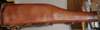
Functional object - Leather "leg of Mutton" gun case
... As used by recreational shooters and the safe carriage of firearms manufactured by Holden and Frost...Trafalgar Holden Museum 74 Waterloo Rd Trafalgar gippsland As used by recreational shooters and the safe carriage of firearms manufactured by Holden and Frost Item holds social significance manufactured by Holden and Frost Leather gun case G.B.L. ...As used by recreational shooters and the safe carriage of firearms manufactured by Holden and FrostItem holds social significance manufactured by Holden and FrostEnclosed leather gun case leather strap on top handle and shoulder strapG.B.L.leather, gun case -
 Whitehorse Historical Society Inc.
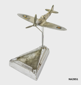
Ash Tray, c1944
... |Plane made during by a member of the R.A.A.F as a recreational activity using hand tools. Generally they were nickel plated on returning home....|Plane made during by a member of the R.A.A.F as a recreational activity using hand tools. Generally they were nickel plated on returning home. ...Base and plane from Bruce Reynolds estate. Cleaned and assembled by Ted Arrowsmith and plane and tray joined together with a new fitted chrome rod for support.|Plane made during by a member of the R.A.A.F as a recreational activity using hand tools. Generally they were nickel plated on returning home.Small brass caste of an aircraft, hand finished and then nickel plated by a serviceman on active service. Silver in colour with red, white and blue R.A.A.F. roundals. Mounted on a chrome rod fixed to the ash traymetalcraft, electroplated nickel silver, personal effects, smoking accessories -
 Warrnambool and District Historical Society Inc.
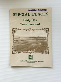
Pamphlet - Special Places Lady Bay Warrnambool, Philprint Warrnambool, 1989
... Areas covered in the written information include: Formation of the Coast, Archaeological survey, Gunditjmara History, vegetation, history and recreational uses of the Lady Bay area. The map shows special places of interest including past and present navigational aids, sites of shipwrecks and other historical places of interest. ...Areas covered in the written information include: Formation of the Coast, Archaeological survey, Gunditjmara History, vegetation, history and recreational uses of the Lady Bay area. The map shows special places of interest including past and present navigational aids, sites of shipwrecks and other historical places of interest. ...This pamphlet was produced for the Warrnambool Branch of the National Trust of Australia (Victoria) for Heritage Week, April 16-23, 1989 and contains information written by Warrnambool residents about their locality. This was a co-operative venture by people with a common interest in protecting the natural environment near their home. Areas covered in the written information include: Formation of the Coast, Archaeological survey, Gunditjmara History, vegetation, history and recreational uses of the Lady Bay area. The map shows special places of interest including past and present navigational aids, sites of shipwrecks and other historical places of interest. The Warrnambool Branch of the National Trust was originally formed in March 1969 and merged with the Port Fairy Branch in late 1970. In October 1979, the Warrnambool Branch was reformed and operated into the late 1990's. This is an example of a publication produced by the Warrnambool Branch of the National Trust Australia (Victoria). It provides historical information and perspectives of the recreational uses in and around Lady Bay Warrnambool.An A2 piece of buff coloured thick paper folded into eight to make an A5 pamphlet. The front cover has green printing with the National Trust symbol of three eucalyptus leaves in green. There is a brown sepia photograph showing a view across Lady Bay with the suspension bridge across the Merri River in the foreground, Viaduct Road in the middle ground and the breakwater in the background. There is a purple inked stamp on the top right hand corner. The rear cover has brown writing and includes logos of bodies who assisted with the publication. There is a brown line drawing of the viaduct and pier at the Warrnambool Breakwater. The inside of the unfolded pamphlet contains a map of Lady Bay and adjacent area showing places of interest and shipwrecks marked in red circlesFront cover: Special Places Lady Bay Warrnambool National Trust of Australia (Victoria) Warrnambool Branch Ronald J. Cummingwarrnambool, lady bay warrnambool, national trust australia victoria warrnambool branch, heritage week 1989, lady bay shipwrecks -
 Yarra City Council
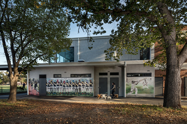
Artwork, other - Mural, Fiona McMonagle, The Park, 2022
... 'The Park' focuses on the recreational uses of Citizens Park and its role as a community space in an area that is changing rapidly. ...'The Park' focuses on the recreational uses of Citizens Park and its role as a community space in an area that is changing rapidly. ...'The first panel celebrates the long history of runners that use the park. Richmond Harriers Athletics Club was established in 1913 and is the oldest athletics club in Victoria. The central panel depicts young female footballers and recognises female athletes and the popularity of women and girls' teams in contemporary sports. The final panel depicts a children’s cricket match. The young players are represented through the depiction of a game that is part of our national psyche and firmly entrenched in Australian culture.'Inner-city parks like Citizens Park have many diverse uses. They provide places to play, to exercise and to relax. They are spaces for community and are often subject to competing values and interests. The re-development of the Jack Dyer Pavilion at Citizens Park allows for the growth of the local community’s diverse interests and values and enables participation and interaction. 'The Park' focuses on the recreational uses of Citizens Park and its role as a community space in an area that is changing rapidly. The mural consists of three panels that address inclusivity and access to sport. Three core sporting groups who each utilize the pavilion and park as a public recreational space are represented: children, sport teams and runners. In fostering the representation of these groups, the panels also attest to the past, present, and future of this important space.Three sporting groups are represented: athletics/runners, women footballers in line formation and young cricketers in action/play. Accompanying plaquesport, women, community, richmond, parks -
 Trafalgar Holden Museum
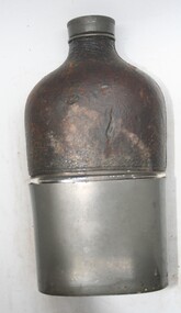
Functional object - Whiskey flask
... Used in early 19th and 20th centuries, typical flask used during recreational and social activities to hold liquor...Trafalgar Holden Museum 74 Waterloo Rd Trafalgar gippsland Used in early 19th and 20th centuries, typical flask used during recreational and social activities to hold liquor Sold by Holden and Frost C1900's Flask Drink container Whiskey flask Screw top glass flask, top half leather bound with metal removable cup covering Functional object Whiskey flask ...Used in early 19th and 20th centuries, typical flask used during recreational and social activities to hold liquorSold by Holden and Frost C1900'sScrew top glass flask, top half leather bound with metal removable cup coveringflask, drink container, whiskey flask -
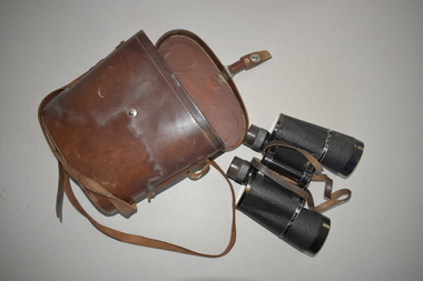 Warrnambool and District Historical Society Inc.
Binoculars, Carl Zeiss, 1940s
... Binoculars have been in existence for over 100 years for recreational and military use. The Carl Zeiss factory in Jena, Germany was founded in 1846 and manufactured optical systems such as cameras, binoculars and riflescopes and industrial measurement devices and medical equipment. ...Warrnambool and District Historical Society Inc. 2 Gilles Street (south of Merri St) Warrnambool great-ocean-road Binoculars have been in existence for over 100 years for recreational and military use. The Carl Zeiss factory in Jena, Germany was founded in 1846 and manufactured optical systems such as cameras, binoculars and riflescopes and industrial measurement devices and medical equipment. ...Binoculars have been in existence for over 100 years for recreational and military use. The Carl Zeiss factory in Jena, Germany was founded in 1846 and manufactured optical systems such as cameras, binoculars and riflescopes and industrial measurement devices and medical equipment. Binoculars are still commonly used today. These binoculars have no known local provenance and are retained for display purposes.These are a pair of black binoculars with a brown leather strap. It is contained within a brown leather case. The case has a brown leather strap and metal buckle and a metal and leather clasp. Carl Zeiss Jena Binoctar 1389040 7 X 50 vintage optical goods, history of warrnambool -
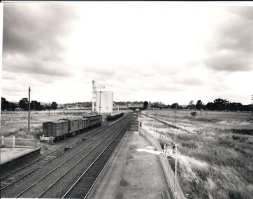 Hume City Civic Collection
Photograph, 1/01/1971
... The photograph was taken when railway land on either side of the tracks was used for recreational purposes and agricultural related activities. ...Hume City Civic Collection 44 Macedon Street Sunbury melbourne The photograph was taken when railway land on either side of the tracks was used for recreational purposes and agricultural related activities. ...The photograph was taken when railway land on either side of the tracks was used for recreational purposes and agricultural related activities. The local sports ground is on the RHS of the photograph and was used to stage a number of the town's events.A black and white photograph of a section of the two railway platforms and three sets of rail tracks with a stone bridge in the distance. Four rail carriages and eight goods trucks are on a railway siding near a wheat silo. There is open land on either side of the rail tracks.sunbury railway station, wheat silos, railways, macedon street rail bridge., george evans collection -
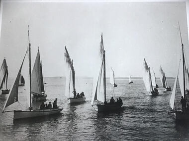 Queenscliffe Maritime Museum
Photograph - Couta Boats under sail
... From the 1970s onwards a community of enthusiasts started restoring old couta boats to use recreationally....From the 1970s onwards a community of enthusiasts started restoring old couta boats to use recreationally. The Couta Boat has been associated with the fishermen of Queenscliff from the first quarter of the 20th Century, and still is of significance due to the popularity of this boat as a leisure sailing vessel. couta couta boat sailing fishing port phillip queenscliff 2 Reproduced photographs of couta boat fishing fleet under full sail in Queenscliff Photograph Couta Boats under sail ...A Couta boat is a type of sailing boat originally designed and built in Victoria, Australia, around Sorrento, Queenscliff and along Victoria's west coast as far west as Portland. It was originally used as a traditional fishing boat from around 1870 until the 1930s, although it survived as a commercial fishing vessel until the 1950s. From the 1970s onwards a community of enthusiasts started restoring old couta boats to use recreationally.The Couta Boat has been associated with the fishermen of Queenscliff from the first quarter of the 20th Century, and still is of significance due to the popularity of this boat as a leisure sailing vessel.2 Reproduced photographs of couta boat fishing fleet under full sail in Queenscliffcouta, couta boat, sailing, fishing, port phillip, queenscliff -
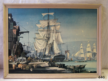 Flagstaff Hill Maritime Museum and Village
print - Picture of Sailing Ship, Rowland Hilder 1905 -1993, 20th Century
... Sailing ships slowly declined in use and number until now, most sailing ships are used for recreational purposes....Sailing ships slowly declined in use and number until now, most sailing ships are used for recreational purposes. This picture shows the widespread use of sail for trading purposes. flagstaff hill warrnambool shipwrecked-coast flagstaff-hill flagstaff-hill-maritime-museum maritime-museum shipwreck-coast flagstaff-hill-maritime-village maritime painting by Rowland Hilder painting of sailing ship None Picture of a sailing ship at a wharf with other ships in the background, by artist Rowland Hilder. ...The use of sails to propel a ship along its course dates back at least to 3000 BC., to the Egyptians who used sails to move their vessels up and down the Nile. Sailing ships then developed with the Greeks, Romans, Phoenicians, Vikings and other cultures. Their use was widespread until the 19th century which saw the development of the steam engine, and more recently, the diesel engine. Sailing ships slowly declined in use and number until now, most sailing ships are used for recreational purposes.This picture shows the widespread use of sail for trading purposes.Picture of a sailing ship at a wharf with other ships in the background, by artist Rowland Hilder. Natural wood frame.Noneflagstaff hill, warrnambool, shipwrecked-coast, flagstaff-hill, flagstaff-hill-maritime-museum, maritime-museum, shipwreck-coast, flagstaff-hill-maritime-village, maritime painting by rowland hilder, painting of sailing ship -
 Eltham District Historical Society Inc
Film - Video (DVD), Melbourne and Metropolitan Board of Works, Yarra River Conference Proceedings; a Board of Works centenary event, 13-16 April 1991
... Conceived and presented by a group of prominent historians as a chronological 'trip down the river in time', and profusely illustrated with slides, this segment traced the various impacts that urban and rural growth, development of marine commerce, recreational uses, and environmental problems have had on the Yarra during a century and a half of European occupation. ...Conceived and presented by a group of prominent historians as a chronological 'trip down the river in time', and profusely illustrated with slides, this segment traced the various impacts that urban and rural growth, development of marine commerce, recreational uses, and environmental problems have had on the Yarra during a century and a half of European occupation. ...Yarra River Conference History Segment [Noted on VHS tape jackets "Due to unavoidable circumstances, the quality of these tapes in some setions is less than desired."] The Yarra River Conference, organised by the Board of Works as part of the Centenary Celebrations, was held in the Board's Head Office Theatrette from 13-16 April, 1991. A segment of the Conference focussed on the role that the Yarra River has played in relation to the historical development of Melbourne. Conceived and presented by a group of prominent historians as a chronological 'trip down the river in time', and profusely illustrated with slides, this segment traced the various impacts that urban and rural growth, development of marine commerce, recreational uses, and environmental problems have had on the Yarra during a century and a half of European occupation. As no formal written paper of this combined presentation is available, these two video-tapes provide a record for anyone who has an interest in tis fascinating aspect of the Yarra's history. The speakers who combined to present this segment are identified on the cover of Tape 2. Tape 1 (2 hours) 1838-1863 Deputy ?? to Utility Early navigators of the Yarra River; developing the port of Melbourne; the gold rush and its effect on the new colony; punts and bridges; water supply; pollution of the Yarra; the discovery of gold and early settlement of the Yarra valley; floods of 1839 and 1863. 1863-1891 Formation of the Harbour Trust; Coode Canal; pollution of the Yarra by industry; aborigines, gold miners, timber getters in the Upper Yarra areas; bridges; the flood of 1891. Tape 2 ( 1 1/2 hours) 1892-1934: People Begin to See Beauty and Romance to the River Henley-on-Yarra; realignment of the Yarra; MMBW is responsible for a sewerage system; new docks to cope with increased overseas trade; development of recreational parks; new reservoirs; timber production and timber tramways; bushfire; flood of 1934. 1935-1970: The River is Neglected Still, Except When it Proves Useful Bushfirs of 1939; the end of many sawmills; birth of tourism; increased interest in conservation and preservation of land for open space; further augmentation of water supply system; birth of containerisation changes the port; environmental concerns gain momentum. Speakers Dr Tony Dingle *, Department of Economic History, Monash University Dr Carolyn Rasmussen *, History Consultant Prof. Graeme Davison, History Department, Monash University Mr. Tom Griffiths, Lecturer in Public History, Monash Uiversity Mr. Patrick Miller, History Consultant Mr. Colin Jones, Author and Historian * Co-authors of the Board's history, 'Vital Connections'.video recording, yarra river, conference proceedings -
 Kew Historical Society Inc
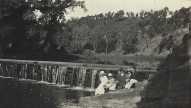
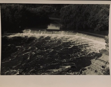
Photograph, Richardson Family at Dight's Falls, 1920
... The area around Dight’s Falls was and is frequently used for recreational activities....The area around Dight’s Falls was and is frequently used for recreational activities. This photograph forms part of the collection assembled by the historian Dorothy Rogers, that was donated to the Kew Historical Society by her son John Rogers in 2015. ...Dight’s Falls in Studley Park is an artificial weir built on a natural rock bar across the Yarra. The weir was built in the 1840s to provide water to the ‘Ceres’ flour-mill, one of the first in Victoria. The falls were later to become known as Dight’s Falls after the owners of the mill. Later, a pumping station was built on the Kew side of the river, which pumped water uphill to a reservoir in Walmer Street that provided water to the Melbourne Botanical Gardens and to Albert Park Lake. The area around Dight’s Falls was and is frequently used for recreational activities.This photograph forms part of the collection assembled by the historian Dorothy Rogers, that was donated to the Kew Historical Society by her son John Rogers in 2015. The manuscripts, photographs, maps, and documents were sourced by her from both family and local collections or produced as references for her print publications. Many were directly used by Rogers in writing ‘Lovely Old Homes of Kew’ (1961) and 'A History of Kew' (1973), or the numerous articles on local history that she produced for suburban newspapers. Most of the photographs in the collection include detailed annotations in her hand. The Rogers Collection provides a comprehensive insight into the working habits of a historian in the 1960s and 1970s. Together it forms the largest privately-donated collection within the archives of the Kew Historical Society.Black and white photograph of the Richardson family seated on the Kew side of Dight's Falls in 1920. One of the girls in the photograph was to become the Melbourne historian Dorothy (Richardson) Rogers.Annotation on reverse: "Mrs D. Rogers, 29 Park Crst Kew. Dights Falls 1920"dight's falls - kew (vic) - fairfield (vic), sport and recreation - kew (vic), dorothy rogers -
 Kew Historical Society Inc
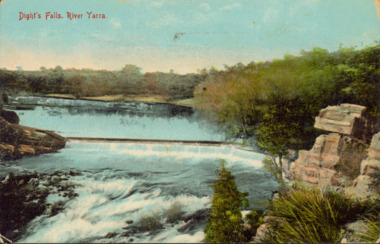
Postcard - Dight's Falls, River Yarra, c.1911
... The area around Dight’s Falls was and is frequently used for recreational activities....The area around Dight’s Falls was and is frequently used for recreational activities. Dated postcard allowing one to analyse the form of the Falls in 1911 Dight's Falls dight's falls - kew (vic) - fairfield (vic) Obverse: "Dight's falls, Kew" Reverse: "Printed in Great Britain Writing in ink on Reverse: "31/3/1911 / To dear Nell with best wishes for a happy birthday from your old friend Eve / [Addressed to] "Mrs N Dunn, Prahran" Franked Victorian 1d stamp on Reverse top right Colour postcard, of Dight's Falls on the River Yarra between Kew and Fairfield. ...Dight’s Falls in Studley Park is an artificial weir built on a natural rock bar across the Yarra. The weir was built in the 1840s to provide water to the ‘Ceres’ flour-mill, one of the first in Victoria. The falls were later to become known as Dight’s Falls after the owners of the mill. Later, a pumping station was built on the Kew side of the river, which pumped water uphill to a reservoir in Walmer Street that provided water to the Melbourne Botanical Gardens and to Albert Park Lake. The area around Dight’s Falls was and is frequently used for recreational activities.Dated postcard allowing one to analyse the form of the Falls in 1911Colour postcard, of Dight's Falls on the River Yarra between Kew and Fairfield. The photograph is taken looking upstream towards the Falls from the Kew side, from the embankment in the vicinity of the Pumping Station. Obverse: "Dight's falls, Kew" Reverse: "Printed in Great Britain Writing in ink on Reverse: "31/3/1911 / To dear Nell with best wishes for a happy birthday from your old friend Eve / [Addressed to] "Mrs N Dunn, Prahran" Franked Victorian 1d stamp on Reverse top rightdight's falls, dight's falls - kew (vic) - fairfield (vic) -
 Kew Historical Society Inc
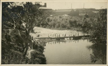
Photograph - Crossing Dights' Falls on the Yarra by foot
... The area around Dight’s Falls was and is frequently used for recreational activities....The area around Dight’s Falls was and is frequently used for recreational activities. Dight's falls River Yarra -- Kew - Abbotsford Reverse: "M Holmes" Rare original print photograph of people walking across Dight's Falls when the river flow was low. ...Dight’s Falls in Studley Park is an artificial weir built on a natural rock bar across the Yarra. The weir was built in the 1840s to provide water to the ‘Ceres’ flour-mill, one of the first in Victoria. The falls were later to become known as Dight’s Falls after the owners of the mill. Later, a pumping station was built on the Kew side of the river, which pumped water uphill to a reservoir in Walmer Street that provided water to the Melbourne Botanical Gardens and to Albert Park Lake. The area around Dight’s Falls was and is frequently used for recreational activities.Rare original print photograph of people walking across Dight's Falls when the river flow was low. View west towards Abbotsford. Photograph taken from Kew side of river above the Falls.Reverse: "M Holmes"dight's falls, river yarra -- kew - abbotsford -
 Kew Historical Society Inc
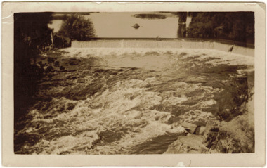
Photograph - The Race at Dight's Falls, 1925
... The area around Dight’s Falls was and is frequently used for recreational activities....The area around Dight’s Falls was and is frequently used for recreational activities. dight's falls river yarra yarra -- kew (vic.) ...Dight’s Falls in Studley Park is an artificial weir built on a natural rock bar across the Yarra. The weir was built in the 1840s to provide water to the ‘Ceres’ flour-mill, one of the first in Victoria. The falls were later to become known as Dight’s Falls after the owners of the mill. Later, a pumping station was built on the Kew side of the river, which pumped water uphill to a reservoir in Walmer Street that provided water to the Melbourne Botanical Gardens and to Albert Park Lake. The area around Dight’s Falls was and is frequently used for recreational activities.Original, black and white positive of water flowing over the 'Race' at Dight's Falls in MelbourneInscribed verso: "The Race at Dight's Falls / River Yarra Melbourne / 1.3.25" "Kodak Print"dight's falls, river yarra, yarra -- kew (vic.) -
 Kew Historical Society Inc
Photograph - Dight's Falls, 1920s
... The area around Dight’s Falls was and is frequently used for recreational activities....The area around Dight’s Falls was and is frequently used for recreational activities. One of a series of photographs, probably taken by Henry Christian of the Yarra River in Kew. ...Dight’s Falls in Studley Park is an artificial weir built on a natural rock bar across the Yarra. The weir was built in the 1840s to provide water to the ‘Ceres’ flour-mill, one of the first in Victoria. The falls were later to become known as Dight’s Falls after the owners of the mill. Later, a pumping station was built on the Kew side of the river, which pumped water uphill to a reservoir in Walmer Street that provided water to the Melbourne Botanical Gardens and to Albert Park Lake. The area around Dight’s Falls was and is frequently used for recreational activities.One of a series of photographs, probably taken by Henry Christian of the Yarra River in Kew. An item from an outstanding and diverse photographic collection, assembled by members of the Christian and Washfold families of Kew.River Yarra at Dight’s Falls, Kew/Fairfield photographed from Kew bank.dight's falls, river yarra, christian-washfold collection -
 Kiewa Valley Historical Society
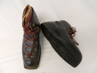
Ski Boots - Cross Country, mid 1900's
... These cross country ski boots are part of the pioneer ski recreational sport in the Victoria Alps. The mid 1900's saw the Victorian Alps begin to be used for recreational skiing, especially cross country. ...Kiewa Valley Historical Society Mount Beauty Information Centre 31 Bogong High Plains Rd Mt Beauty high-country These cross country ski boots are part of the pioneer ski recreational sport in the Victoria Alps. The mid 1900's saw the Victorian Alps begin to be used for recreational skiing, especially cross country. ...These cross country ski boots are part of the pioneer ski recreational sport in the Victoria Alps. The mid 1900's saw the Victorian Alps begin to be used for recreational skiing, especially cross country. The majority of skiers at this point in time were either from the SEC Vic. Kiewa Hydro Scheme or from Melbourne. International skiers had better ski fields (ski lodges etc.) in Europe, the U.S.A. and Canada. With greater and better coverage of the Winter Olympics and some medal wins, skiing became more interesting and rewarding for city dwellers in Melbourne and Sydney.These ski boots are of great significance to the Kiewa Valley as it demonstrates that winter sports in the region have and still do attract not only skiers but also provide an employment (even though seasonal) avenue which "livens up" a small rural community and provides for a diversity of land usage which did not exist in the 1800's. These brown cross country ski boots, "Grief" brand have "cherry" inserts with cream laces, within the main boot. The boots have red and black laces and crossover tie flaps (to allow for maximum front foot entry. These boots do not have any ski clips to hold firm those restraints (quick release) on the skis (like "modern boots and skis). The heel section has the red Greif "W" pattern.At the underside of the rubber sole in freehand script "Cresta"snow skiing, ski boots, winter recreational sports. -
 Eltham District Historical Society Inc
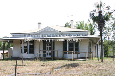
Photograph - Digital Photograph, Alan King, Edendale Farm Homestead, 29 January 2008
... The council considers this area will become increasingly important to the local community for recreational use.2 Educational programs aim to encourage community involvement to ensure the long-term rehabilitation and protection of natural bushland areas. ...The council considers this area will become increasingly important to the local community for recreational use.2 Educational programs aim to encourage community involvement to ensure the long-term rehabilitation and protection of natural bushland areas. ...Edendale Farm is Nillumbik Shire Council's environment centre situated in Gastons Road, Eltham between the railway and the Diamond Creek. The homestead on the property was built in 1896 and is of historical significance, being the subject of a Heritage Overlay under the Nillumbik Planning Scheme. The Edendale property was originally part of an extensive land purchase in 1852 from the Crown by pioneer Eltham farmer Henry Stooke. He initially purchased 51 acres and later expanded his holdings by purchasing another three adjacent Crown allotments extending northerly from Josiah Holloway's Little Eltham subdivision. Despite clearing the land, Stooke did not build on this property, choosing to live on his property "Rosehill" at Lower Plenty. In 1896 Thomas Cool, Club Manager of the Victoria Coffee Palace in Melbourne purchased 7 acres of the original Stooke land and built the house now known as Edendale. Cool did not farm the land, instead using it as a gentleman’s residence, retiring to Eltham at weekends. In 1918 he purchased an additional 7 acres but in 1919 he sold the property. Later owners included J.W. Cox, the Gaston family and D. Mummery. In the 1980s the Eltham Shire Council purchased the site for use as a Council depot, but this use did not proceed. Subsequently, it was used as the Council pound. The Edendale Farm Pet Education and Retention Centre was established in the summer of 1988/1989 and was set up to replace the existing dog kennels with a high standard pet retention centre. The design style of the building was established to compliment the features of the existing house. It was equipped with 10 retention pens, a veterinary room and a pet education area where school children and other interested parties learnt about pet care procedures. It was later developed into a community farm and was run by an advisory committee and in 2000 it became an Environment Centre. In early 2006 an advisory committee was established for the development of a master plan for future development at Edendale Farm. The committee included Russell Yeoman, a former long-time shire planner and founding member of the Eltham District Historical Society. At the time of filming the Master Plan and future for Edendale was about continuing to develop Edendale as a centre of environment learning and looking at expanding displays and school program, running a lot more of life-long learning and workshops around sustainable living. Covered under Heritage Overlay, Nillumbik Planning Scheme. Published: Nillumbik Now and Then / Marguerite Marshall 2008; photographs Alan King with Marguerite Marshall.; p101 A sharp turn from busy Wattletree Road by the railway line, brings a surprise. Only 1.4 km from Eltham’s centre, sheep feed, blissfully unaware of the hectic suburban activity so close by. At the entrance to the 5.6ha Edendale Farm is another surprise. A work of art that looks like huge tree trunks transformed into bowler and top-hatted men. The Fences Act 1968 by Tony Trembath with Mark Cain and John Doyle, 1996, is classified by the National Trust of Australia as having Regional Significance. The title refers to a government act on disputes between neighbors over the placement of fences and boundaries. This takes a ‘wry swipe’ at a community divided by trivial squabbles. It also celebrates making do with limited resources.1 Further along on the left, the office wall is decorated with a massive Eltham Copper Butterfly, designed by Robert Tickner and made by school children with used plastic bottles and other waste material. Nillumbik Council runs Edendale as an Environmental Education Centre, to help preserve and enhance the local environment. As early as 1988 the former Eltham Shire Council realised Edendale’s importance in meeting people’s needs, particularly of children, to enjoy farmland. The centre, with the Eltham North Reserve to the north - including remnant bushland and open parkland - makes up the major part of the public open space for this area. The council considers this area will become increasingly important to the local community for recreational use.2 Educational programs aim to encourage community involvement to ensure the long-term rehabilitation and protection of natural bushland areas. Edendale is used by people of all ages - from school children to adults - for environmental programs and workshops, as well as for recreation, to enjoy the domestic animals and to picnic. Edendale is also home to the Environmental Works staff who manage reserves and roadsides and support Nillumbik Friends environmental groups. The Friends propagate plants at the nursery, which grows indigenous plants and sells these to the public.3 The centre demonstrates the sustainable living the farm teaches, with features like solar hot water and drive lighting and for the fireplace, logs of recycled cardboard. Edendale has had a varied history as a dog pound and even as a retreat for Thomas Cool, Club Manager of the Victoria Coffee Palace in Melbourne. His single-storey weatherboard house built in 1896, which still stands, was grander than most homes in Eltham. Although such buildings were common in many other parts of Melbourne, Eltham’s poverty and remoteness did not encourage such construction. The Victorian rectangular-shaped house, with a corrugated iron roof and veranda, has elegant large rooms, leadlight windows, ceiling roses, two bay windows and ornately carved wooden fireplace surrounds. Cool bought seven acres (2.8ha) from pioneer Eltham farmer Henry Stooke’s 200 acre (81ha) farm, which he had bought from the Crown in 1852. In 1918 Cool bought an extra seven acres (2.8ha) but in 1919 sold the estate to farmer John Cox. In 1933 Cox sold Edendale to Mrs Elizabeth Gaston, after whom the road leading to the centre was named. The property was owned by several Gaston family members, who called it Edendale, then by a police constable, Douglas Mummery, until the Shire of Eltham bought it in 1970. Oddly Edendale was known as Mummery’s for almost 20 years, although Mummery owned it only for a short time.4 The shire used Edendale as a dog pound until amalgamation with other municipalities in 1996. The pound then moved to the Yan Yean Road, Plenty site, which had been used by the former Diamond Valley Shire Council. To the west and north the centre is bounded by Diamond Creek and on the east by the Melbourne-Hurstbridge railway line. Part of the Research creek forms the centre’s southern boundary.This collection of almost 130 photos about places and people within the Shire of Nillumbik, an urban and rural municipality in Melbourne's north, contributes to an understanding of the history of the Shire. Published in 2008 immediately prior to the Black Saturday bushfires of February 7, 2009, it documents sites that were impacted, and in some cases destroyed by the fires. It includes photographs taken especially for the publication, creating a unique time capsule representing the Shire in the early 21st century. It remains the most recent comprehenesive publication devoted to the Shire's history connecting local residents to the past. nillumbik now and then (marshall-king) collection, edendale farm -
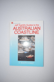 Warrnambool and District Historical Society Inc.
Book, Hodder & Stoughton (Australia) Pty Ltd, Australian Coast Line, 1987
... Some of the information regarding places to stay and recreational facilities etc will date over the years and the book will be of less use....Some of the information regarding places to stay and recreational facilities etc will date over the years and the book will be of less use. ...This book details the places and towns along the south coast of Australia. It contains potted histories and information for tourists. Some of the information regarding places to stay and recreational facilities etc will date over the years and the book will be of less use.This book is of minor interest as a summary of the places along the coastline of Victoria and as a useful resource book in our library.This s a soft-cover book of 128 pages. It has a blue cover with a colour photograph and red and white printing on the front cover and a colour photograph of the author and black printing on the back cover. The pages contain printed material, black and white photographs and maps and sketches. coastline of victoria, history of warrnambool -
 Warrnambool and District Historical Society Inc.
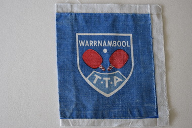
Badge Cotton, Warrnambool Table Tennis Association
... recreational activity. This badge is retained as memento of the Warrnambool Table Tennis Association. It is useful for display purposes. table tennis WARRNAMBOOL T.T.A. Cloth square most likely used ...The Warrnambool Table Tennis Association has been operating since 1958. The centre is located is in Cramer Street, Warrnambool in Albert Park. Many local churches have table tennis centres. It is a popular recreational activity. This badge is retained as memento of the Warrnambool Table Tennis Association. It is useful for display purposes.Cloth square most likely used for attaching to a uniform. The centre features a shield shaped white outline inside of which is text , two red table tennis bats and a white ball. Inside at the bottom of the shield is text enclosed in a further white outline. The background is blue. The above is printed on white cloth which surrounds the badge on all sides. WARRNAMBOOL T.T.A. table tennis -
 Warrnambool and District Historical Society Inc.
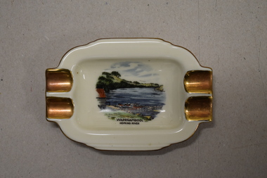
Ashtray, Alka Kunst, Warrnambool Hopkins River, c. 1960
... The boatshed is no longer there with sections of the building being relocated to a site in Henna Street and used for indoor recreational purposes....The boatshed is no longer there with sections of the building being relocated to a site in Henna Street and used for indoor recreational purposes. This ash tray is retained as an example of a local tourist souvenir sold to tourists in the 1960s. ...This item was bought as a souvenir of Warrnambool in the mid 20th century when cigarette smoking was more widespread and was socially acceptable. Tourism in Warrnambool has been an important industry for over 100 years. In the late 19th century Warrnambool was promoted as a spa resort with its mild climate, sea bathing and its hot and cold sea water baths complex. Today visitors come in winter for the May Racing Carnival and to see the Southern Right whales at Logans Beach and in summer they come for a beach holiday. The image on the dish shows the Warrnambool Hopkins River near its mouth. The boatshed is no longer there with sections of the building being relocated to a site in Henna Street and used for indoor recreational purposes.This ash tray is retained as an example of a local tourist souvenir sold to tourists in the 1960s. This is a small white china dish made in an oval shape and slightly raised from the surface on which it sits. The ends of the dish have four gold coloured indents for stubbing cigarettes. There is a gold rim around the edge of the dish and a coloured image of the old boat shed and jetty on the Hopkins River in Warrnambool. On the base of the dish is the logo of the maker and printed details.Warrnambool Hopkins River Alka Kunst Bavaria tourism in warrnambool, history of warrnambool -
 Kiewa Valley Historical Society
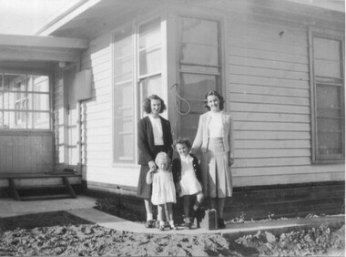
Photos - Mills Family x 15
... recreational time. 2.& 3. The "70 Lakeside Ave" photos show the type of housing provided by the SECV and that the garden hadn't been created. 4. SEC marshalling yards, Mt Beauty c 1940s-50s. An historic photo of 1940s/50s buses used ...Brian and Jill Mills lived with their children at Lakeside Ave. Mt Beauty. Brian was in the airforce.4 photos were taken during the construction of the Kiewa Hydro Electric Scheme. 1. The "Mills Kids" beside the river - show the fashion of the time and how families spent their recreational time. 2.& 3. The "70 Lakeside Ave" photos show the type of housing provided by the SECV and that the garden hadn't been created. 4. SEC marshalling yards, Mt Beauty c 1940s-50s. An historic photo of 1940s/50s buses used to transport KHES workers to their work sites, some of which were on the High Plains.15 large photos scanned in colour. 5 have labels written on the backOn the back "Brian Mills" (in airforce uniform); "Mills Kids / 78 L/side Ave"; "70 Lakeside Ave"; "70 L/side Ave" and "SEC Marshalling yards - Mt Beauty (and Donor's name and address.lakeside ave mt beauty, brian mills -
 Kiewa Valley Historical Society
Ammunition Box - Remington America
... Used by hunters, farmers and recreational shooters in the Kiewa Valley. ...Manufacturer of fire arms and ammunition. Founded in 1816. It was one of the oldest gun makers in the US. Used by hunters, farmers and recreational shooters in the Kiewa Valley.Wooden cubic shaped box with black print on each side including the makers name, Remington Arms Co. Inc. of Bridgeport, Conn., USAIn black print on each side. Varying quality of legible words.remington arms, ammunition box, hunters -
 Bendigo Military Museum
Photograph - Staff Retirement - Army Survey Regiment, Fortuna, Bendigo, c1989
... used for marketing purposes. The novelty of this quirky “drive past” event was that Kev was well known as a part-time car salesman and often took the opportunity of assisting new staff in buying a car. Kev was a qualified pilot and often took time on weekends to take unit staff and their families on recreational...used for marketing purposes. The novelty of this quirky “drive past” event was that Kev was well known as a part-time car salesman and often took the opportunity of assisting new staff in buying a car. Kev was a qualified pilot and often took time on weekends to take unit staff and their families on recreational ...These two photos were most likely taken in the volleyball court area of the Army Survey Regiment, part of the grounds of Fortuna, Bendigo, in c1989. The occasion was probably to farewell SSGT Kevin Boehm, who was a cartographic draughtsman, after 22 years of service in the ADF. It is likely Bendigo Toyota was approached to loan their miniature Toyota Tarago; a vehicle used for marketing purposes. The novelty of this quirky “drive past” event was that Kev was well known as a part-time car salesman and often took the opportunity of assisting new staff in buying a car. Kev was a qualified pilot and often took time on weekends to take unit staff and their families on recreational flights over Bendigo and Albury-Wodonga. His other claim to fame was he was “charge happy”, a tendency to prefer charges against offending soldiers rather than offer them a warning.These two photos were most likely taken in the volleyball court area of the Army Survey Regiment, part of the grounds of Fortuna, Bendigo, in c1989. The photographs were on 35mm negative film and were scanned at 96 dpi. They are part of the Army Survey Regiment’s Collection. .1) and .2) - Photo, black & white, c1989, SSGT Kevin Boehm. No personnel are identifiedroyal australian survey corps, rasvy, army survey regiment, army svy regt, fortuna, asr -
 Kiewa Valley Historical Society
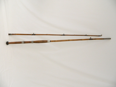
Rod Fishing, circa early 1900's
... This bamboo fishing rod was used in the mid to late 1900's and demonstrates that local production of recreational fishing poles was at a high level and their demand was high. ...Kiewa Valley Historical Society Mount Beauty Information Centre 31 Bogong High Plains Rd Mt Beauty high-country This bamboo fishing rod was used in the mid to late 1900's and demonstrates that local production of recreational fishing poles was at a high level and their demand was high. ...This bamboo fishing rod was used in the mid to late 1900's and demonstrates that local production of recreational fishing poles was at a high level and their demand was high. Imported recreational sporting goods from either the United Kingdom, the United States of America or Asia countries was due to the larger lead up times from these suppliers and the greater import costs from slower ocean supply ships. It was only after World War II that the trade influx from other countries has supplied cheaper goods. This recreational fishing pole is highly significant to the Kiewa Valley as it demonstrates that recreational fishing has been evolved from the need to supply a balanced diet by the early pioneer families of fish from the major Kiewa rivers. The ability of the Kiewa Valley rivers to provide a good fishing environment (high protein diet) for both early indigenous families and early pioneers was the important food source that provided for a balanced diet and the higher level of nutritious development of both body and mind. This two piece wooden fishing Rod is made from bamboo shafts or poles, one length thicker than the other. The smaller diameter shaft is the top end and fits into the longer thicker shaft at a stainless steel tube end.The smaller shaft has a stainless steel reinforcement ring where both shafts fit together. At the bottom end of the thick shaft is a black rubber "stopper" or "foot". There are two stainless steel rings, each with a reel holding "bulge" which allows for the the reel's "prongs" to be secured. The top ring has a greater diameter allowing it to move up and down the shaft/pole to secure the top "prong" firmly onto the shaft/pole.recreation, river, rod, fishing, industry, fish -
 Kiewa Valley Historical Society
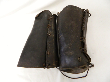
Gaiters Riding, Late 19th Century
... They were used throughout the valley and high plains areas both by horse riders herding cattle and the recreational rider of both sexes. ...These gaiters where used circa 1800's to mid 1900's, by horse riders "cattle men" to protect their shins and long trousers against wear and tear. They were used rather than having expensive boots damaged. Gaiters were a lot easier to fasten and clean than boots. They were used in the Kiewa Valley and the High Plains grazing areas.These gaiters were part of a cattleman's "out fit". The Gaiters were easily cleaned and did away with expensive riding boots. They were used throughout the valley and high plains areas both by horse riders herding cattle and the recreational rider of both sexes. After the 1950s more recreational riders from Melbourne ventured onto the high plains and not so rugged mountain slopes. Small settlements such as Mount Beauty, Bogong village and Falls Creek provided a secure backdrop for short term horse back adventures. The increasing pressure of city life provided a greater flow of stressed out city dweller to find the peace and quiet that city life does not have. Horse riding preceded the modern trail bikes and other recreational vehicles of the late 1900s. Thick leather tapered gaiters with six metal Hooks and Leather lacing through metal eyelets. All bar two eyelets have a metal reinforced punch holes. Left gaiter missing most of lacing.horse, country, leather, gaiters, high, grazing, cattlemen, laces, studs -
 Kiewa Valley Historical Society
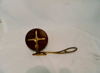
Reel Fishing, Circa 1920's to 1940's
... use of reels and rods by non indigenous fisher persons are also very effective especially if raised in the valley. These items are significant because they demonstrate the harvesting of fish from valley rivers and streams is one of continuation from the first human habitation of this region. The ability to harvest the natural food source of the valley's rivers and streams has come from earlier survival requirement to one of recreational ...These reels where used by a local family in catching Murray Cod and trout in the Kiewa Rivers and Murray River. This old Pilot side cast fishing reel was made in the late 20's & early 30's They were used in the mid 1950s. Although the original inhabitants (Aborigine tribe) would have used spears for fishing the use of reels and rods by non indigenous fisher persons are also very effective especially if raised in the valley.These items are significant because they demonstrate the harvesting of fish from valley rivers and streams is one of continuation from the first human habitation of this region. The ability to harvest the natural food source of the valley's rivers and streams has come from earlier survival requirement to one of recreational pleasure. Brass & Wooden Frame Side Casting Fishing Reel. This reel has 2 winding bakelite handles.Pilot, Tag states W. Davies Please return.recreation, river, kiewa, fishing, industry, reel, side, casting, davies