Showing 15 items matching "reef drives"
-
 Rutherglen Historical Society
Map, 1908
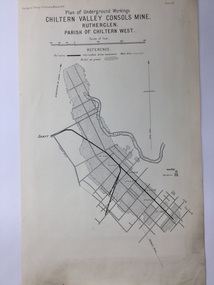
... ...Reef Drives...Mining map of one of the first mines in Rutherglen area ( Chiltern West) Gold Rutherglen Mining Chiltern Underground Mine Map Geological Survey Reef Drives Geographical Survey of Victoria, Memoir, No6. ...This is a map produced as part of a book entitled.. It is also stamped on the back in blue ink with an oval ring and the words North of England Institute. Newcastle. Mining & Meterolgical Faculty. Purchased on 23rd July 2017 by the Society after research by member Simon Killeen. Mining map of one of the first mines in Rutherglen area ( Chiltern West)Cream paper, black printing, rectangle with a drawingGeographical Survey of Victoria, Memoir, No6. Plate XX Plan of Underground Workings CHILTERN VALLEY CONSOLS MINE, RUTHERGLEN, PARISH OF CHILTERN WESTgold, rutherglen, mining, chiltern, underground mine map, geological survey, reef drives -
 Stawell Historical Society Inc
Map, Charles C Reilly, Oriental & North Cross Reef Mine showing underground drives, 3/5/1900
... Oriental & North Cross Reef Mine showing underground drives...Stawell Historical Society Inc 46 Longfield St Stawell grampians mining gold map Charles C Reilley 3.5.00 Underground Survey of Mines Stawell c1900 Oriental & North Cross Reef Mine showing underground drives Map Charles C Reilly ...Underground Survey of Mines Stawell c1900Charles C Reilley 3.5.00 mining, gold, map -
 Federation University Historical Collection
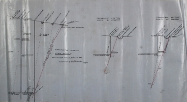
Plan, Underground Workings New Australasian Company Creswick, not dated
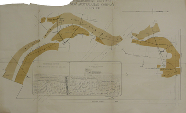
... A plan of the underground working of the New Australasian Mine at Creswick, showing Wheeler's Bridge Road, a transverse section on the West Main Reef Drive and Line AB. It als shows the locations of the Red streak or Australasian Gutter, Reef wash, Eastern Wash, Australasian and Eaglehawk Shaft and prospecting drives....mining plans cgt creswick new australasian company wheeler's bridge red streak gutter australasian gutter reef wash eastern wash australiasian shaft eaglehawk shaft A plan of the underground working of the New Australasian Mine at Creswick, showing Wheeler's Bridge Road, a transverse section on the West Main Reef Drive and Line AB. It als shows the locations of the Red streak or Australasian Gutter, Reef wash, Eastern Wash, Australasian and Eaglehawk Shaft and prospecting drives. ...A plan of the underground working of the New Australasian Mine at Creswick, showing Wheeler's Bridge Road, a transverse section on the West Main Reef Drive and Line AB. It als shows the locations of the Red streak or Australasian Gutter, Reef wash, Eastern Wash, Australasian and Eaglehawk Shaft and prospecting drives.mining, plans, cgt, creswick, new australasian company, wheeler's bridge, red streak gutter, australasian gutter, reef wash, eastern wash, australiasian shaft, eaglehawk shaft -
City of Kingston
Photograph - Colour, 31 January 1993
... The section of Ocean Reef Drive and Palm Beach Drive in Patterson Lakes appears to be a recent development with many spare blocks and new houses under construction....The section of Ocean Reef Drive and Palm Beach Drive in Patterson Lakes appears to be a recent development with many spare blocks and new houses under construction. ...Patterson Lakes is a suburb in the City of Kingston that is built one kilometre upstream of the mouth of the Patterson River. The area is bordered by the Patterson River and Eel Race Drain which enters the Kananook Creek. The suburb consists predominantly of newer housing developments and the tidal canal system of the development joins Port Phillip Bay. Patterson Lakes and the Kananook Creek were previously part of the extensive Carrum Carrum Swamp. The area was once a source of fish and eels for the Mayone-Bulluk clan of the Bunurong people. Over time the area was drained and in 1973 investigations commenced into the development of a unique residential area that would be built adjacent to canals and waterways. It was originally proposed to be known as "Gladesville". The development would give the suburb's homeowners access to Port Phillip Bay "from their back door". Circa 1974, the area was rezoned from rural to residential and named Patterson Lakes. Development has been continuous since the 1970s with construction of residential housing, schools, shopping centres, marinas, a hotel and library.Laminated colour aerial photograph of the Carrum and Patterson Lakes region within City of Kingston. This 1993 image includes Patterson River Secondary College, Roy Dore Reserve, Kananook Creek and Nepean Highway. The railway line can be seen as it veers inland from Eel Race Road, Seaford. The section of Ocean Reef Drive and Palm Beach Drive in Patterson Lakes appears to be a recent development with many spare blocks and new houses under construction.Black typed lettering on white adhesive label: 31.1.93 Black typed lettering on white adhesive label: 27E/7140 31/1/93 12.55 pm Black typed lettering on white label: 7140 Yellow round adhesive label located on left sidepatterson lakes, seaford, kananook creek, carrum carrum swamp, canals and waterways -
 The Beechworth Burke Museum
Postcard, 1920
... 8169 Be / Also near Wallaby Reef Workings / Relics of Rechabite Reef (locality) workings. / Shaft in bed of creek. Wheel used to drive sheadd (?) ...It can provide important information on the types of tools utilised and the impact of the mining on the environment. beechworth mining gold mining quartz mining wallaby reef mine mine battery head 8169 Be / Also near Wallaby Reef Workings / Relics of Rechabite Reef (locality) workings. / Shaft in bed of creek. Wheel used to drive sheadd (?) ...This postcard depicts the set-up of an abandoned gold mine. This includes a water wheel and other mining implements next to a creek. The postcard inscription indicates that this image is of the remains of the Wallaby Reef battery and water wheel. Wallaby Reef was discovered in 1864, and a prospecting claim established a four head battery and water wheel. Quartz was mined there, with gold also discovered at this location at a later date. By 1878 the mine was no longer resulting in rich deposits, this resulted in the miners moving their search for gold closer to the river where they were able to access more gold. This was in approximately 1879. In 1882 a rich deposit was found. In 1908 the battery was closed, and the mine finished. This photo was taken in 1920 and shows the deterioration of the site since its closure. Gold mining was crucial to the development of the Beechworth area. It has strong research and historical value because the clarity of the photo shows all the minute details of the mining equipment. The text on the back also indicates the mine is the Wallaby Mine, which was used for 45 years to find gold and quartz. Therefore, due to the location being quickly abandoned, this site is a rich location for historical study on gold mining during the 1900s. It can provide important information on the types of tools utilised and the impact of the mining on the environment.Black and white postcard photograph on card.8169 Be / Also near Wallaby Reef Workings / Relics of Rechabite Reef (locality) workings. / Shaft in bed of creek. Wheel used to drive sheadd (?) / stamp battery too I believe near B'worth 1920?beechworth, mining, gold mining, quartz mining, wallaby reef mine, mine battery head -
 Bendigo Historical Society Inc.
Document - TYPEWRITTEN ACCOUNT OF JOH MCCAVISTON'S WONDERFUL ESCAPE FROM THE HUSTLERS REEF MINE, 1873
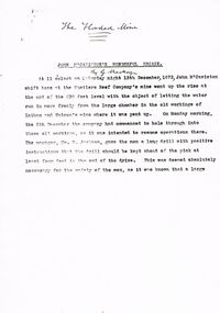
... Reef mine, 1873). Detailed story of shift boss, M'Caviston who descended into the flooding mine to warn workers below (who had actually left somewhat before) and who was himself trapped. The water in the shaft rose to a much higher level but M'Caviston was saved by being able to take refuge in a drive that had a 'stulling' (a mound of stones under a raised portion of the drive - allowing for an amount of trapped air). ...Reef mine, 1873). Detailed story of shift boss, M'Caviston who descended into the flooding mine to warn workers below (who had actually left somewhat before) and who was himself trapped. The water in the shaft rose to a much higher level but M'Caviston was saved by being able to take refuge in a drive that had a 'stulling' (a mound of stones under a raised portion of the drive - allowing for an amount of trapped air). ...Typewritten 10-page account of ''John McCaviston's Wonderful Escape'' (from the Hustlers Reef mine, 1873). Detailed story of shift boss, M'Caviston who descended into the flooding mine to warn workers below (who had actually left somewhat before) and who was himself trapped. The water in the shaft rose to a much higher level but M'Caviston was saved by being able to take refuge in a drive that had a 'stulling' (a mound of stones under a raised portion of the drive - allowing for an amount of trapped air). The account concludes as follows: ''The preservation of his life was discussed from a scientific point of view, and diverse opinions were expressed, and doubts (sic)'' (there is no page 11). No date on this document; handwritten on front page is ''The Flooded Mine'' ''By G Mackay'' (Occasional handwritten notations to text)document, names of bendigo pioneers, bendigo goldfields -
Federation University Historical Collection
Book, Glenfine South and South Berry Journal
... davies south east reef drive...Gift of the Squire Family glenfine south south berry sleemans mining gold mining glenfine consols reef weights of quartz blacksmiths tools Australian and eagle davies south east reef drive brawns eaglehawk junction simons letter machinery puddlng plant poppet heads winding plant creswick mosquito creek frenchmans gully spring hill A. ...This Book is associated with former Ballarat School of Mines Student Richard Squire (1875-1876). Gift of the Squire FamilyGreen water marked linen covered journal with maroon spine with red feint lined blue pages. Label on front cover is cream with black printing JOURNAL with handwritten DATA RISIS GLENFINE SOUTH -SOUTH BERRY G.S & S.B Hand written in black and red ink. Plan in back with scale 20 chains to one inch - Has an index. Handwritten on title page in black ink Address of sawmiller T. J. Brown, Mount Rowan D. W. Hambly 317 Ligar St, Ballarat J. Freeman, C/O Mrs H Simons, Lynch St, Footscray Sleemans Prescription for the bladder in 19009 Mixture No 55983 Tabloids No 55982glenfine south, south berry, sleemans, mining, gold mining, glenfine consols, reef, weights of quartz, blacksmiths tools, australian and eagle, davies south east reef drive, brawns, eaglehawk junction, simons letter, machinery, puddlng plant, poppet heads, winding plant, creswick, mosquito creek, frenchmans gully, spring hill, a. h. welsh, squire, petticoat gully -
 Bendigo Historical Society Inc.
Book - H. A & S. R. WILKINSON COLLECTION: SHARE REGISTER BOOK
... On the front inside page a note in pencil given by Cath Ferguson - Balmoral Drive - 03/07/1998 to James Lerk, also a stamp McDonald's Reefs Gold Mining Company No Liability. ...On the front inside page a note in pencil given by Cath Ferguson - Balmoral Drive - 03/07/1998 to James Lerk, also a stamp McDonald's Reefs Gold Mining Company No Liability. ...Leather bound share register book. On the front inside page a note in pencil given by Cath Ferguson - Balmoral Drive - 03/07/1998 to James Lerk, also a stamp McDonald's Reefs Gold Mining Company No Liability. The book has 243 pages the first 56 pages are cut. Company recorded in the book are: New Charscharlton (?), New Chum Syncline, Central Napoleon, Ironbark South, Central Deborah. South Virginia, New Don, Castley Syndicate, Napoleon Reefs, Deborah Limited. The book covers the years from 1934 to 1940.share registry, h.a. & s.r. wilkinson, bendigo businesses -
 Rutherglen Historical Society
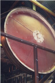
Image, c1990
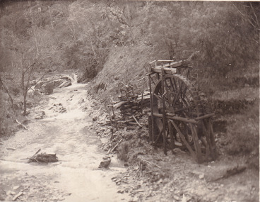
... drives the stampers. This is one of a series of photographs of the Rutherglen Gold Battery. The battery's purpose was to crush quartz from nearby quartz reefs and extract gold from within. ...drives the stampers. This is one of a series of photographs of the Rutherglen Gold Battery. The battery's purpose was to crush quartz from nearby quartz reefs and extract gold from within. ...This photograph is a view of the flywheel that drives the stampers. This is one of a series of photographs of the Rutherglen Gold Battery. The battery's purpose was to crush quartz from nearby quartz reefs and extract gold from within. The battery was erected in 1908 and consists of a five-head battery, Wilfrey table, Bergin pan, portable steam engine and shed. The battery was restored in 2011/12 and can be viewed daily between 9.00am and 5.00pm. See website for details. Colour photograph of a large piece of machinery inside a buildinggold battery, gold processing -
 Tarnagulla History Archive
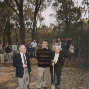
Photograph: Havelock Reef Ceremony, 28th April, 1995
... A colour photograph depicting Don Clark, Dick Sandner and Lorna Goltz at a ceremony to open drive to tunnel under the hill, Havelock Reef, South Poverty Reef, Tarnagulla. ...A colour photograph depicting Don Clark, Dick Sandner and Lorna Goltz at a ceremony to open drive to tunnel under the hill, Havelock Reef, South Poverty Reef, Tarnagulla. ...Donald Clark Collection. A colour photograph depicting Don Clark, Dick Sandner and Lorna Goltz at a ceremony to open drive to tunnel under the hill, Havelock Reef, South Poverty Reef, Tarnagulla. Original photograph. -
 Bendigo Historical Society Inc.
Plan - W.W. Gully and Footwall
... drives and shafts. Margaret Roberts gold Chewton shaft gold mine Phillips Reef W.W. ...Wattle Gully Gold Mine was at Chewton. A footwall in mining is the underlying rock mass beneath an inclined fault, vein, or mineral deposit. It is named because miners typically walk on this lower surface while the hanging wall lies above them. In mining operations, it serves as a crucial, stable reference point, often housing underground drives and shafts. Transverse section showing W.W. Gully and Phillips Reef. Seperate transverse diagrams of north and south of xcut. Additions by W. Edwards, 30.7.45, Plan forms part of the Margaret Roberts Collection of mining records. margaret roberts, gold, chewton, shaft, gold mine, phillips reef, w.w. gully, footwall -
 Bendigo Historical Society Inc.
Plan - Victoria Quartz Gold Mine, Unknown
... Written on accompanying label: "Victoria Reef, underground plan'. Plan shows shaft, drives and geological features. ...Written on accompanying label: "Victoria Reef, underground plan'. Plan shows shaft, drives and geological features. ...Victoria Quartz Gold Mine was situated on Victoria Hill, Bendigo. Victoria Hill is situated on the Marong Road, opposite the Gold Mines Hotel. Victoria Hill was one of the richest areas on the Bendigo Goldfield. It had many successful mines, including Lansell's '180' and the Victoria Quartz, once the deepest gold mine in the world. At the turn of the century, this was the site of one of the premier mines on the Bendigo goldfield. In 1908, it boasted the world's deepest shaft - 4,478 feet (1,365 metres). The shaft reached a depth of 4,613 feet (1,406 metres) in 1910. In 1857 eight small claims in this area had been merged to form the Victoria Reef Quartz Mining Co. Another merger in 1877 led to the formation of the Victoria Quartz Co. For the next three decades, the mine produced consistent profits. In 1910, water burst into the claim, flooding the shaft and halting operations. The company baled water for six months then handed the mine over to the tributers who worked the upper levels for the share of the profits. The mine closed in 1913, having produced over 48,000 ounces of gold and paid dividends of £99,600.Printed in black text on light tan paper: 'Underground workings, Victoria Quartz Co''. Written on accompanying label: "Victoria Reef, underground plan'. Plan shows shaft, drives and geological features. Plan forms part of the Margaret Roberts Collection.gold mining, gold, bendigo, victoria quartz gold mine, victoria reef -
 Bendigo Historical Society Inc.
Plan - St. Mungo Mine
... Plan shows poppet head, shaft and drives. Written on side: 'Section across line of reef' and 'Old workings'. ...reef in Eaglehawk, part of the greater Bendigo goldfields. It was positioned in the vicinity of Victoria Street and Upper Road, and near Baldock Court, Eaglehawk. gold mining gold transverse section St. Mungo Mine Eaglehawk Baldock Court Hand drawn plan on cream map paper, on top of plan: St. Mungo Mine, Eaglehawk. Plan shows poppet head, shaft and drives ...The St Mungo mine was a historic gold mine located on the New Chum line of reef in Eaglehawk, part of the greater Bendigo goldfields. It was positioned in the vicinity of Victoria Street and Upper Road, and near Baldock Court, Eaglehawk. Hand drawn plan on cream map paper, on top of plan: St. Mungo Mine, Eaglehawk. Plan shows poppet head, shaft and drives. Written on side: 'Section across line of reef' and 'Old workings'. Poppet head has St. Mungo flag on top. Plan forms part of the Margaret Roberts Collection.gold mining, gold, transverse section, st. mungo mine, eaglehawk, baldock court -
 Flagstaff Hill Maritime Museum and Village
Letter - Ferrier Letter, Leonard Robertson, Marine Department, 5 January 1938
... Drive is named in honour of the hero. Flagstaff Hill Maritime Museum and Village Great Ocean Road Shipwreck Coast la bella william ferrier bill ferrier lady bay 1905 10th november 1905 11th november 1905 parliament of the commonwealth prime minister australian government new zealand flagstaff hill warrnambool shipwrecked coast flagstaff hill maritime museum maritime museum flagstaff hill maritime village leonard Robertson rescue Frank Ferrier La Bella Reef Otto Bayer Inscribed in blue ink: "OWNER. ...This letter of sympathy is written to the widow of William Ferrier who rescued Captain Mylius and another seaman from the shipwreck, La Bella, at Warrnambool. Leonard Robertson, from Auckland, was II Mate of the La Bella. The letter was written from the Marine Dept. Queensland. Many newspaper accounts narrate the rescue and evidence given at the Marine Court of Inquiry. A book "Leonard Robertson, the Whangaroa & La Bella"/Jack Churchouse was printed. William Ferrier was born in Warrnambool and it is reported that he was a member of the lifeboat crew and served some years in the lighthouse service. During the La Bella rescue Ferrier used his dinghy, as he was an experienced fisherman of 25 years old. Ferrier, moved to Queenscliff at some stage and died at the Geelong hospital after having a seizure at sea. Ferrier's 15 years old son was having his birthday and fishing with him at the time. He was survived by his widow and 13 children. Otto Bayer who had informed Robertson of Ferrier's death was a crew member of the lifeboat. The site of the La Bella wreck lies in Lady Bay Warrnambool, at La Bella Reef - named after the fact. Transcript: Marine Dept Queensland 5.1.38 Dear Mrs Ferrier, Please accept my Sincerest Sympathy with you and your family in the loss of your husband. Mr. Otto Bayer advised me of the sad news and as I was II Mate of the La Bella when she was lost at Warrnambool I feel that I should write this short note and express my deep feelings in your loss. It is now 32 years since the wreck of which your husband was the hero. It is sad to think that we are all fading away and looking back I can see Bill Ferrier out in his boat at the La Bella it brings it all back to my mind as I write. A good man, and sailorman, is gone but never forgotten. Again expressing my deepest sympathy to you all Believe me, Yours Sincerely Leonard Robertson.This item is of historical significance in relation to the La Bella shipwreck as it is written and signed by a survivor and witness of the rescue. It is a single letter to the wife of the hero William 'Bill' Ferrier. The Ferrier family have a long social history with Warrnambool and Ferrier Drive is named in honour of the hero. The letter front is written on a lined and yellowed paper that has been repaired. The repair runs from top to bottom and has been done with cello tape. A small repair runs across the middle a couple of centimetres from the top and for approximately four centimetres down the middle. There are some small tears to the edges, particularly on fold creases. There are small brown age spots to peripheral areas. This is a sympathy letter from Leonard Robertson, II Mate and survivor of the La Bella to the widow of William (Bill) Ferrier rescue hero on his death. Inscribed in blue ink: "OWNER. G. FERRIER / LOANED. TO. BE / PHOTOGRAPHED / 27/4/76"flagstaff hill maritime museum and village, great ocean road, shipwreck coast, la bella, william ferrier, bill ferrier, lady bay, 1905, 10th november 1905, 11th november 1905, parliament of the commonwealth, prime minister, australian government, new zealand, flagstaff hill, warrnambool, shipwrecked coast, flagstaff hill maritime museum, maritime museum, flagstaff hill maritime village, leonard robertson, rescue, frank ferrier, la bella reef, otto bayer -
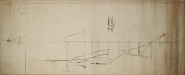
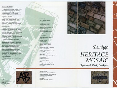 Bendigo Historical Society Inc.
Pamphlet - MERLE HALL COLLECTION: ROSALIND PARK CREATIVE VILLAGE BENDIGO PROJECT PAMPHLET, 1995
... Section 4: Shown here is the Iron Bark mine on the Sheepshead reef. It has an interesting pattern of drives, stopes and winzes. ...Section 4: Shown here is the Iron Bark mine on the Sheepshead reef. It has an interesting pattern of drives, stopes and winzes. ...Merle Hall Collection: Rosalind Park Creative Village Bendigo Project Pamphlet for Rosalind Park Lookout - two copies. One side of the pamphlet has a layout image of the five sections of the mosaic and the poppet head base. The sections are numbers 1 to 5 Section 1: A stylized representation of the main Bendigo Goldfield based on a geological plan (Publish in 1992). It shows the lines of reef, including the famous Hustlers, Garden Gully and New Chum. Section 2: A typical cross section of the Bendigo Goldfields Section 3: The mine layout shown in this design features part of the Garden Gully line of reef. Section 4: Shown here is the Iron Bark mine on the Sheepshead reef. It has an interesting pattern of drives, stopes and winzes. Section 5: In this section the artist uses gold as her inspiration. The larger mosaic shows quartz veins winding through the earth containing gold in its various forms. The smaller mosaic represents the atomic structure of gold. It shows the nucleus, the six shells of the atom, their electrons and orbits. The other side of the pamphlet describes the background of the community arts project, the artist, and volunteer workers, also notes mentioning the Bendigo community history. It also lists the donors for funding and business's that supported the project, with special thanks to Eric Wilkinson - Geological adviser, the students and staff from Camp Hill, St Killians and Violet Street primary schools. BRIT and La Trobe University, Bendigo.bendigo creative village, rosalind park