Showing 90 items matching "reef lines and mines"
-
 Bendigo Historical Society Inc.
Document - MINING WARDEN COLLECTION: BENDIGO HISTORICAL MINING RECORDS
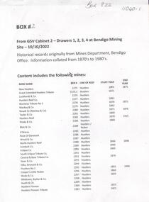
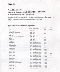
... ...mines......mines...Mines along the following reef lines are described: Hustlers Millers Derby Paddy's Gully Ben # range from 2275 to 2584 Example of entry: Sydney Garden Gully Quartz Mining Co., Ben # 2371, Millers Reef, 1872 - 1875....History House 11 Mackenzie Street Bendigo goldfields BENDIGO Mining mining warden's records mines reef lines Historical records originally from the Mining Warden's Office, Mines Department, Bendigo. ...Historical records originally from the Mining Warden's Office, Mines Department, Bendigo. A summary document lists the mine name; the Ben #; the line of reef located on, the start and end year. Information collated from 1870's to 1980's. Each mine's data is enclosed in a manilla folder within the box. Mines along the following reef lines are described: Hustlers Millers Derby Paddy's Gully Ben # range from 2275 to 2584 Example of entry: Sydney Garden Gully Quartz Mining Co., Ben # 2371, Millers Reef, 1872 - 1875.bendigo, mining, mining warden's records, mines, reef lines -
 Bendigo Historical Society Inc.
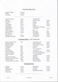
Plan - Independent Mine lines of reef
... Independent Mine lines of reef......Independent Mine lines of reef...Independent Mine lines of reef...Independent Mine lines of reef Plan forms part of the Margaret Roberts Collection....Independent Mine lines of reef gold mining gold Bendigo Independent Mine lines of reef Independent Mine lines of reef Plan forms part of the Margaret Roberts Collection. ...Independent Mine lines of reefIndependent Mine lines of reef Plan forms part of the Margaret Roberts Collection.gold mining, gold, bendigo, independent mine lines of reef -
 Bendigo Historical Society Inc.
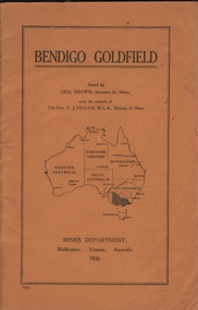
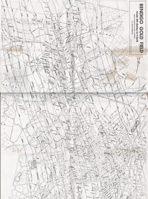
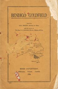
Book - BENDIGO GOLDFIELD
... Map of goldfield showing reef lines and mines attached to back cover....Map of goldfield showing reef lines and mines attached to back cover. Book BENDIGO GOLDFIELD ...booklet, 51 pages. 'Bendigo Goldfield' issued by Geo Brown, Secretary for Mines. Mines Department 1936. Contains information on the geology of the Bendigo goldfield and major lines of reef and mines. Map of goldfield showing reef lines and mines attached to back cover.bendigo, mining, bendigo goldfield -
 Bendigo Historical Society Inc.
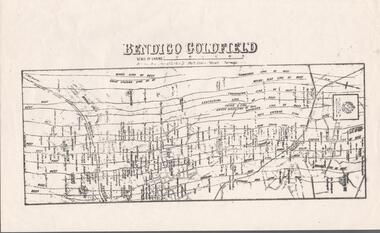
Map - BENDIGO GOLDFIELDS MAP
... Map of the Bendigo Goldfield, showing reef lines, mines and significant geographical features such as Monument Hill, Quartz Hill and Diamond Hill. ...History House 11 Mackenzie Street Bendigo goldfields BENDIGO Mining bendigo goldfields Map of the Bendigo Goldfield, showing reef lines, mines and significant geographical features such as Monument Hill, Quartz Hill and Diamond Hill. ...Map of the Bendigo Goldfield, showing reef lines, mines and significant geographical features such as Monument Hill, Quartz Hill and Diamond Hill. On the back of map 'Department of Mines, Victoria. Plan of Bendigo Goldfield.bendigo, mining, bendigo goldfields -
 Bendigo Historical Society Inc.
Plan - Pearl Gold Mine shafts
... Drawn on paper with black pen, written on top of plan 'Pearl MIne transverse section, New Chum and Sheepshead Reef lines of reef' Plan forms part of the Margaret Roberts Collection of mining records. ...The Pearl Gold Mine was near Stone Street, Long Gully. Margaret Roberts gold gold mine Bendigo Pearl Gold Mine Stone Street Long Gully Drawn on paper with black pen, written on top of plan 'Pearl MIne transverse section, New Chum and Sheepshead Reef lines of reef' Plan forms part of the Margaret Roberts Collection of mining records. ...The Pearl Gold Mine was near Stone Street, Long Gully.Drawn on paper with black pen, written on top of plan 'Pearl MIne transverse section, New Chum and Sheepshead Reef lines of reef' Plan forms part of the Margaret Roberts Collection of mining records. margaret roberts, gold, gold mine, bendigo, pearl gold mine, stone street, long gully -
 Bendigo Historical Society Inc.
Map - Geological survey of Bendigo Goldfields
... It shows geological conditions, gold reef lines and mine sights. Three sections are laminated together. ...It shows geological conditions, gold reef lines and mine sights. Three sections are laminated together. ...Three Geological survey maps of the Bendigo Gold Fields joined together. The three sections are Eaglehawk, Golden Square and Spring Gully. It shows geological conditions, gold reef lines and mine sights. Three sections are laminated together. The maps were produced by the Victorian Department of Manufacturing and Industry Development geological survey, bendigo gold fields -
 Bendigo Historical Society Inc.
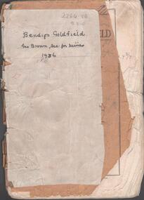
Booklet - Albert Richardson Collection: Bendigo Goldfield, MInes Department, Victoria 1936, 1936
... ...reef lines...Hogan, M.L.A., Minister of Mines. Mines Department, Melbourne, Victoria, Australia, 1936.Content includes: historical information; recent development and future prospects, geology and lines of reef. ...Albert Richardson gold mining goldfield reef lines 1936 Mines Department On front cover 'Bendigo Goldfield, Geo Brown, Sec. for Mines, 1936' written in black pen. ...Albert Richardson was an expert on the history of the Bendigo Goldfield. The Albert Richardson Park at Victoria Hill, is named in his honour. He was a prominent member of the Bendigo Historical Society. Fifty one page booklet. On front page: Bendigo Goldfield, issued by Geo Brown, Secretary for Mines, under the authority of The Hon. E.J. Hogan, M.L.A., Minister of Mines. Mines Department, Melbourne, Victoria, Australia, 1936.Content includes: historical information; recent development and future prospects, geology and lines of reef. Reef lines described are: Tysons, Lightning Hill, Hustlers, Derby, Paddy's Gully, Garden Gully, Deborah, Sheepshead, New Chum, Nell Gwynne, British and Foreign, Napoleon, Lancashire, Carshalton, Thistle, Christmas and Birds. On front cover 'Bendigo Goldfield, Geo Brown, Sec. for Mines, 1936' written in black pen. On first page 'A.Richardson, 29 Harrison Street, Bendigo' The booklet is annotated throughout by Albert Richardson, for example, the mines along the New Chum Line are further described with their date of formation, sill heights and area of claim.albert richardson, gold mining, goldfield, reef lines, 1936, mines department -
Bendigo Historical Society Inc.
Document - MINING WARDEN COLLECTION: BENDIGO HISTORICAL MINING RECORDS
... Individual mine data is enclosed in a manilla folder within the box. ...Individual mine data is enclosed in a manilla folder within the box. ...Historical records originally from the Mining Warden's Office, Mines Department, Bendigo. Information collated from 1870's to 1980's. A summary document lists the BEN# from 3311 to 3440 and describes the mine name; the BEN#, the line of reef located on, the start and end year. Individual mine data is enclosed in a manilla folder within the box. Reef lines listed are: New Chum Nell Gwynne Sample entry: Ballerstedt, #3326, New Chum line of reef, 1853 to 1871.bendigo, mining, mining warden records -
Bendigo Historical Society Inc.
Document - MINING WARDEN COLLECTION: BENDIGO HISTORICAL MINING RECORDS
... Individual mine data is enclosed in a manilla folder within the box. ...Individual mine data is enclosed in a manilla folder within the box. ...Historical records originally from the Mining Warden's Office, Mines Department, Bendigo. Information collated from 1870's to 1980's. A summary document lists the BEN# from 3151 to 3310 and describes the mine name; the BEN#, the line of reef located on, the start and end year. Individual mine data is enclosed in a manilla folder within the box. Reef lines listed are: New Chum Napoleon Sample entry: Adventure and Advance, #3162, New Chum line of reef, 1871 to 1880.bendigo, mining, mining warden records -
Bendigo Historical Society Inc.
Document - MINING WARDEN COLLECTION: BENDIGO HISTORICAL MINING RECORDS
... Mine data is enclosed in a manilla folder within the box. ...Mine data is enclosed in a manilla folder within the box. ...Historical records originally from the Mining Warden's Office, Mines Department, Bendigo. Information collated from 1870's to 1980's. A summary document lists the BEN# from 2585 to 2800 and describes the mine name; the BEN#, the line of reef located on, the start and end year. Mine data is enclosed in a manilla folder within the box. Reef lines listed are: Paddy's Gully Derby Paddy's Gully/Garden Gully Example of entry: Meridien Quartz Mining Co. 2595, Paddy's/Garden Gully, 1876-1877.bendigo, mining, mining warden records -
Bendigo Historical Society Inc.
Document - MINING WARDEN COLLECTION: BENDIGO HISTORICAL MINING RECORDS
... Individual mine data is enclosed in a manilla folder within the box. ...Individual mine data is enclosed in a manilla folder within the box. ...Historical records originally from the Mining Warden's Office, Mines Department, Bendigo. Information collated from 1870's to 1980's. A summary document lists the BEN# from 3407 to 3532 and describes the mine name; the BEN#, the line of reef located on, the start and end year. Individual mine data is enclosed in a manilla folder within the box. Reef lines listed are: Nell Gwynne British and Foreign Napoleon Sample entry: Combes, 3445.01, British and Foreign reef line, 1888 to 1889.bendigo, mining, mining warden records, nell gwynne, british and foreign, napoleon -
Bendigo Historical Society Inc.
Document - MINING WARDEN COLLECTION: BENDIGO HISTORICAL MINING RECORDS
... Individual mine data is enclosed in a manilla folder within the box. ...Individual mine data is enclosed in a manilla folder within the box. ...Historical records originally from the Mining Warden's Office, Mines Department, Bendigo. Information collated from 1870's to 1980's. A summary document lists the BEN# from 2599 to 4093 and describes the mine name; the BEN#, the line of reef located on, the start and end year. Individual mine data is enclosed in a manilla folder within the box. Reef lines listed are: Garden Gully Birds Sample entry: Great Southern Extended (Yankee shaft) #2616Garden Gully line of reef, 1904 - 1908.bendigo, mining, mining warden records -
Bendigo Historical Society Inc.
Document - MINING WARDEN COLLECTION: BENDIGO HISTORICAL MINING RECORDS
... Individual mine data is enclosed in a manilla folder within the box. ...Individual mine data is enclosed in a manilla folder within the box. ...Historical records originally from the Mining Warden's Office, Mines Department, Bendigo. Information collated from 1870's to 1980's. A summary document lists the BEN# from 3533 to 3745 and describes the mine name; the BEN#, the line of reef located on, the start and end year. Individual mine data is enclosed in a manilla folder within the box. Reef lines listed are: Lancashire Carsharlton Derby Thistle Millers Derby Sample entry: Jersey Reef Claims, #3546, Lancashire line of reef, 1865 to 1882,bendigo, mining, mining warden records -
Bendigo Historical Society Inc.
Document - MINING WARDEN COLLECTION: BENDIGO HISTORICAL MINING RECORDS
... Mine data is enclosed in a manilla folder within the box. ...Mine data is enclosed in a manilla folder within the box. ...Historical records originally from the Mining Warden's Office, Mines Department, Bendigo. Information collated from 1870's to 1980's. A summary document lists the BEN# from 2596 to 3025 and describes the mine name; the BEN#, the line of reef located on, the start and end year. Mine data is enclosed in a manilla folder within the box. Reef lines listed are: Deborah and Sheepshead Sample entry: Irish and Scotch, #2974, Deborah line of reef, start year 1867, end year 1879.bendigo, mining, mining warden records -
Bendigo Historical Society Inc.
Document - MINING WARDEN COLLECTION: BENDIGO HISTORICAL MINING RECORDS
... Reef lines listed are: Garden Gully and Deborah. ...Reef lines listed are: Garden Gully and Deborah. ...Historical mining records originally from the Mining Warden's Office, Mines Department, Bendigo. Information collated from 1870's to 1980's. A summary document lists the BEN# from 2801 to 2955 and describes the mine name; the BEN#, the line of reef located on, the start and end year. Individual mine data is enclosed in a manilla folder within the box. Reef lines listed are: Garden Gully and Deborah. Example of entry: Knee Tributor Co. BEN # 2823, Garden Gully reef, 1870. (no end date given).bendigo, mining, mining warden records -
 Bendigo Historical Society Inc.
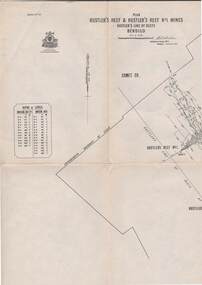
Map - STRUGNELL COLLECTION: HUSTLER'S LINE OF REEF, September 1913
... Drawing shows reef boundary lines .There is an explanatory box showing depth in feet and inches of the mines ....Drawing shows reef boundary lines .There is an explanatory box showing depth in feet and inches of the mines . ...Map, Hustler's Line of Reefs, Hustler's Reef & Hustler's Reef No.1 Mines Bendigo.Plate No. X1V (14) Comet Co. .Bulletin No 33 Signed H.A.Whitelaw. Drawing shows reef boundary lines .There is an explanatory box showing depth in feet and inches of the mines .Underground Survey Office, Bendigo.map, bendigo, hustler's reef & hustler's reef 1 -
Bendigo Historical Society Inc.
Document - MINING WARDEN COLLECTION: BENDIGO HISTORICAL MINING RECORDS
... Individual mine data is enclosed in a manilla folder within the box. ...Individual mine data is enclosed in a manilla folder within the box. ...Historical records originally from the Mining Warden's Office, Mines Department, Bendigo. Information collated from 1870's to 1980's. A summary document lists the BEN# from 3026 to 3150 and describes the mine name; the BEN#, the line of reef located on, the start and end year. Individual mine data is enclosed in a manilla folder within the box. Reef lines listed are: Sheepshead New Chum New Chum/Thistle Sample entry: Polkinhorne and Palk, #3069, New chum line of reef, start date 1870, end date 1875.bendigo, mining, mining warden records, sheepshead reef, new chum reef, thistle reef -
 Bendigo Historical Society Inc.
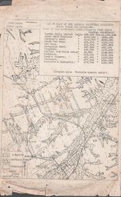
Document - MINING REPORTS - MAP OF PART OF THE BENDIGO GOLDFIELD INCLUDING WHITE HILLS AND EAGLEHAWK
... Map of part of the Bendigo Goldfield including White Hills and Eaglehawk. Map shows reef lines, gullies, railway line, tram route, type of rock, name of mine, Calls and Dividends. ...Victoria Quartz Map of part of the Bendigo Goldfield including White Hills and Eaglehawk. Map shows reef lines, gullies, railway line, tram route, type of rock, name of mine, Calls and Dividends. ...BHS CollectionMap of part of the Bendigo Goldfield including White Hills and Eaglehawk. Map shows reef lines, gullies, railway line, tram route, type of rock, name of mine, Calls and Dividends. Also Deepest Mine Victoria Quartz 4614 ft. Names of Mines are Garden Gully United, Great Ext'd Hustlers, Johnson's Reef, South New Moon, New Moon, Catherine Reef, Virginia, Central Red White & Blue, Ironbark, Kock's Pioneer, Carlisle and the Hercules & Energetic. Map is part of the Albert Richardson Collection of mining documents and research. document, gold, mining reports, mining reports, map of part of the bendigo goldfield including white hills and eaglehawk, pabst bendigo goldfield, garden gully united, great ext'd hustlers, johnson's reef, south new moon, new moon, catherine reef, virginia, central red white & blue, ironbark, kock's pioneer, carlisle, hercules & energetic. victoria quartz -
 Bendigo Historical Society Inc.
Document - MINING WARDEN COLLECTION
... Mines along the following reef lines are described: Huntly Deep Lead Whipstick Neilborough Drover Isabella Slaughteryard Blue Jacket Tyson One Tree Hill Flag Gravel Hill View Hill Lightning Hill Hustlers Ben # range from 2001 to 2274. ...Mines along the following reef lines are described: Huntly Deep Lead Whipstick Neilborough Drover Isabella Slaughteryard Blue Jacket Tyson One Tree Hill Flag Gravel Hill View Hill Lightning Hill Hustlers Ben # range from 2001 to 2274. ...Historical mining records originally from the Mining Warden's Office, Mines Department, Bendigo. A summary document lists the mine name; the BEN #; the line of reef located on, the start and end year. Information collated from 1870's to 1980's. Each mine's data is enclosed in a manilla folder within the box. Mines along the following reef lines are described: Huntly Deep Lead Whipstick Neilborough Drover Isabella Slaughteryard Blue Jacket Tyson One Tree Hill Flag Gravel Hill View Hill Lightning Hill Hustlers Ben # range from 2001 to 2274. Example of entry: Pascoe and Symmonds, Ben # 2217, Lightning Hill Reef, 1863-1885.bendigo, mining, mining warden records -
 Bendigo Historical Society Inc.
Map - MAP OF BENDIGO GOLDFIELDS
... Copy of a map of the Bendigo Goldfields issued by the Dept. of Mines showing lines of reef, mines and streets. ...History House 11 Mackenzie Street Bendigo goldfields MAP Bendigo goldfields Map Goldfields Department of Mines Map. Copy of a map of the Bendigo Goldfields issued by the Dept. of Mines showing lines of reef, mines and streets. ...Map. Copy of a map of the Bendigo Goldfields issued by the Dept. of Mines showing lines of reef, mines and streets. Scale 20 chains to 1 inch. Printed by Cambridge Press, Bendigo. Date unknownmap, bendigo, goldfields, map, goldfields, department of mines -
Bendigo Historical Society Inc.
Document - MINING WARDEN COLLECTION: BENDIGO HISTORICAL MINING RECORDS
... Individual mine data is enclosed in a manilla folder within the box. ...Individual mine data is enclosed in a manilla folder within the box. ...Historical records originally from the Mining Warden's Office, Mines Department, Bendigo. Information collated from 1870's to 1980's. A summary document lists the BEN# from 3754 to 4080 and describes the mine name; the BEN#, the line of reef located on, the start and end year. Individual mine data is enclosed in a manilla folder within the box. Reef lines listed are: Derby Christmas Garden Gully Gravel Hill Thistle Carshalton Myers Flat Birds Hit or Miss Break of Day Crusoe Big Hill line Sample entry: Brilliant Co., BEN# 3757, Garden Gully line of reef, 1870 - 1880.bendigo, mining, mining warden records -
 Bendigo Historical Society Inc.
Document - MINING REPORTS - LOCATION OF SHAFT WITH THE REEF
... Handwritten list by Albert Richardson, with typed copy, of mines on the Garden Gully, Sheepshead, Hustlers, Nell Gwynne and the Deborah, Paddy Gully and Derby Lines of Reef. ...Also a list of prominent mines on the New Chum Line. Document MINING REPORTS - LOCATION OF SHAFT WITH THE REEF ...BHS CollectionHandwritten list by Albert Richardson, with typed copy, of mines on the Garden Gully, Sheepshead, Hustlers, Nell Gwynne and the Deborah, Paddy Gully and Derby Lines of Reef. Also a list of prominent mines on the New Chum Line. document, gold, mining reports, mining reports, location of shaft with the reef, north new moon, suffolk, new moon, south new moon, clarence, new argus, virginia, gt northern golden pyke, constellation, johnsons extd, golden age, princess dagmar, johnson's no 2, nth johnsons, johnsons no 1, confidence extended, windmill hill, koch's pioneer, cornish, carlisle, pandora, garden gully united, catherine reef united, williams united, belmont & saxby, ellenborogh, st mungo, sadowa, lady barkly, south st mungo, united devonshire, south devonshire, pearl, hercules & energetic, ironbark (vict gold mines), victoria consols, victoria quartz (vict reef), lansell's big 180, north old chum, new chum & victoria, old chum, lazarus, 222, new chum united, new chum consolidated - the consolidated, garibaldi, shamrock, hercules, ironbark, south ironbark, little 180, central blue, sheepshead, nth blue, big blue, south blue (lansell's), united hustlers & redan, the redan, comet (lansell's), hustlers reef plus no 1 shaft, old hustlers, gt extended hustlers plus 'pups', royal hustlers reserve nos 1 & 2, fortuna hustlers, new chum syncline, central nell gwynne, monument hill, central deborah, north deborah, deborah, collman &tacchi, lansells sandhurst needle, johnsons no 3 (nelsons) -
 Bendigo Historical Society Inc.
Map - BENDIGO GOLDFIELD MAP
... Streets, Railway Line, Lines of Reefs and mines are shown. Dept. of Mines, Victoria printed on the map. ...Streets, Railway Line, Lines of Reefs and mines are shown. Dept. of Mines, Victoria printed on the map. ...Two not very clear copies of the Bendigo Goldfield Map. Streets, Railway Line, Lines of Reefs and mines are shown. Dept. of Mines, Victoria printed on the map. Shows reefs from Bird's Line of Reefs to Lightning Hill Line of Reef.map, bendigo, goldfields, bendigo goldfield map, lines of reefs, dept. of mines victoria -
 Bendigo Historical Society Inc.
Map - BENDIGO GOLD FIELD - MAP OF PORTION OF THE BENDIGO GOLD FIELD
... Map showing portion of the Bendigo Gold Field showing Alluvial working, shaft sites , streets and lines of reefs.Department of Mines, Victoria. Many mines, lines of reefs and gullies are on the map. ...Many mines, lines of reefs and gullies are on the map. ...Map showing portion of the Bendigo Gold Field showing Alluvial working, shaft sites , streets and lines of reefs.Department of Mines, Victoria. Many mines, lines of reefs and gullies are on the map. Blue Royal Historical Society of Victoria Bendigo Branch stamp on the back.document, bendigo gold field, department of mines, lines of reefs, gullies, mines -
 Bendigo Historical Society Inc.
Document - ALBERT RICHARDSON COLLECTION: SECRETARY FOR MINES ANNUAL REPORT 1911
... Longitudinal sections along the lines of reefs or anticlines within the 8 mile block at Bendigo are shown in a diagram' (diagram not included with notes) Mines and reef lines mentioned in the report are : New Chum line, New Chum Railway mine, Catherine United mine, Hercules and Energetic mine, Garden Gully, Hustlers and Redan, Sheepshead Reef, Sea Mine, Garden Gully, Miller's line of reef and Bendigo Development Mine. ...Longitudinal sections along the lines of reefs or anticlines within the 8 mile block at Bendigo are shown in a diagram' (diagram not included with notes) Mines and reef lines mentioned in the report are : New Chum line, New Chum Railway mine, Catherine United mine, Hercules and Energetic mine, Garden Gully, Hustlers and Redan, Sheepshead Reef, Sea Mine, Garden Gully, Miller's line of reef and Bendigo Development Mine. ...Three page typed report titled ' Notes on diagram showing pitch lines, Bendigo'. Longitudinal sections along the lines of reefs or anticlines within the 8 mile block at Bendigo are shown in a diagram' (diagram not included with notes) Mines and reef lines mentioned in the report are : New Chum line, New Chum Railway mine, Catherine United mine, Hercules and Energetic mine, Garden Gully, Hustlers and Redan, Sheepshead Reef, Sea Mine, Garden Gully, Miller's line of reef and Bendigo Development Mine. The 'old stacks' or chimneys, on Bendigo are described. 'Among the earliest of the stacks built at Bendigo in connexion with Quartz crushing plant, are the two figured in this Annual report No 1 was situate in Sailor's Gully but was demolished about three years ago. This, if not the first, must have been one of the first built, for it had a stone inserted on which chiselled the date 1854. It was built altogether of rough masonry. The other, No. 2, is still standing at the Sheepshead line and was apparently of later date, the upper portion being of brick. They are intersting landmarks of an era that is rapidly passing.' Map attached to report showing location of stacks. Stack at Sailors Gully was near the corner of Murchison Street and Lester Street. The stack at Sheepshead ( Deborah Triangle area) was near the intersection of Belle Vue Road and Adam Street.bendigo, mining, pitch lines bendigo -
 Bendigo Historical Society Inc.
Map - DEPARTMENT OF MINES VICTORIA : PLAN SHOWING PORTION OF THE BENDIGO GOLD FIELD
... Department of Mines Victoria. Plan showing portion of the Bendigo Gold Field. ...Tyler J. J. Department of Mines Victoria. Plan showing portion of the Bendigo Gold Field. ...Department of Mines Victoria. Plan showing portion of the Bendigo Gold Field. On the back is written, in ink, J. J. Tyler 1937 Northern Area. (He was a teacher at Bendigo High - see donation notes). Across the bottom of the map is written ' M. Hill cr. Myrtle & Barnard' .The named reef lines have been numbered with ink across the bottom of the map. The gullies have been coloured with green pencil and a red pencil line is drawn through the western side of the map. Additional information: anticlinal axial lines at surface, alluvial workings, shaft sites, area of Main Goldfield, Deepest mine workings, Gold output of field to 1935, and Dividends paid 1870 - 1935.bendigo, gold mining, bendigo gold field. gold mining. tyler, j. j. -
Bendigo Historical Society Inc.
Map - DEBORAH MINE - MAP OF LINES OF REEF AND MINES (BENDIGO)
... DEBORAH MINE - MAP OF LINES OF REEF AND MINES (BENDIGO)...... Map of Lines of Reef and Mines (Bendigo)....Two adjoining photocopies of part of map of Bendigo Goldfield showing lines of reef, mines, streets, locations and contour lines. ...History House 11 Mackenzie Street Bendigo goldfields MINE Gold deborah mine Deborah Mine Map of Lines of Reef and Mines (Bendigo). ...Two adjoining photocopies of part of map of Bendigo Goldfield showing lines of reef, mines, streets, locations and contour lines. Map is a beige colour with darker lines and letters. Some of the mines have their depths printed beside them. This item is stored in Map drawer 7mine, gold, deborah mine, deborah mine, map of lines of reef and mines (bendigo). -
 Bendigo Historical Society Inc.
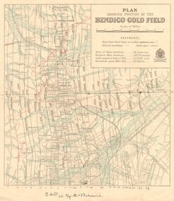
Document - MARKS COLLECTION: ABE LINCOLN CO LEASE
... Nicholas, Mining Surveyor' Sheepshead Reef, Easter reef, Alfred Reef, Allingham Reef,Adventure Reef, Belle Vue Reef, New Chum Reef, Black Lead, Victoria Reef lines shown on map with mine leases marked. ...Nicholas, Mining Surveyor' Sheepshead Reef, Easter reef, Alfred Reef, Allingham Reef,Adventure Reef, Belle Vue Reef, New Chum Reef, Black Lead, Victoria Reef lines shown on map with mine leases marked. ...Two copies of plan for Abe Lincoln Co. Lease, New Chum, Sandhurst. One original, one copy. On top of plan 'Plan Showing Position of the Abe Lincoln Co. Lease, New Chum, Sandhurst' under name 'by H.B. Nicholas, Mining Surveyor' Sheepshead Reef, Easter reef, Alfred Reef, Allingham Reef,Adventure Reef, Belle Vue Reef, New Chum Reef, Black Lead, Victoria Reef lines shown on map with mine leases marked. On bottom of map 'Monument Hill Reef' line marked.bendigo, mining, abe lincoln lease -
 Bendigo Historical Society Inc.
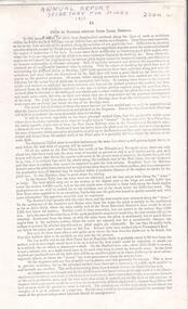
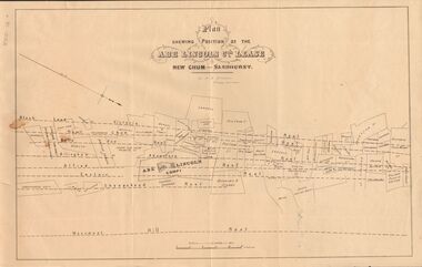
Document - BENDIGO GOLFIELDS HISTORIC MAP
... Bendigo goldfields historic map showing streets, lines of reef, principal shafts. Original map (dept of Mines) with additional material by members of RHSV (Bendigo Branch) . ...History House 11 Mackenzie Street Bendigo goldfields Bendigo map goldfields mines tourism Bendigo goldfields historic map showing streets, lines of reef, principal shafts. ...Bendigo goldfields historic map showing streets, lines of reef, principal shafts. Original map (dept of Mines) with additional material by members of RHSV (Bendigo Branch) . Price 30c. Map; is folded into envelope for sale and storage.bendigo, map, goldfields, mines, tourism -
 Bendigo Historical Society Inc.
Book - JOAN O'SHEA COLLECTION: BENDIGO GOLDFIELD BOOK, 1936
... Buff coloured book issued by Mines Department Melbourne. Victoria Australia 1936. ...History House 11 Mackenzie Street Bendigo goldfields MINING Business mines department Geo. Brown, Secretary for Mines, Mines Department Joan O'Shea collection. ...Joan O'Shea collection. Buff coloured book issued by Mines Department Melbourne. Victoria Australia 1936. Information contained within refers to History, Recent developments and future Prospects, Geology, Lines of Reef for the Bendigo area, information regarding tonnage of gold and values of same at that time. The index at the rear of the book lists all of the mines in the Bendigo area.Geo. Brown, Secretary for Mines, Mines Departmentmining, business, mines department