
Showing 22 items matching "register of machinery"
-
 University of Melbourne, Burnley Campus Archives
Administration, Department of Agriculture, Machinery - General 20/1, 1977-1978
... ...register of machinery...Register of euipment, not vehicles. memoranda other machinery 26.08.1977-08.06.1978....machinery memoranda administration register of machinery Manila folder with shoelace tie. ...machinery, memoranda, administration, register of machinery -
 Bendigo Historical Society Inc.
Document - MISS G ALICE JONES COLLECTION: ACCOUNT
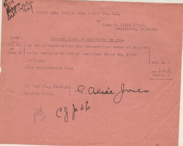
... To costs under Solicitors Remuneration Order of registering transfer to you of Machinery Lease No. 10878 Bendigo £2.2.0 and Paid registration fees 16/0, total £2.18.0. ...To costs under Solicitors Remuneration Order of registering transfer to you of Machinery Lease No. 10878 Bendigo £2.2.0 and Paid registration fees 16/0, total £2.18.0. ...Pink paper, South Nell Gwynne Gold Mining Co. N.L. to Miss G. Alice Jones, Solicitor, Bendigo dated Feb18 to June 10, 1942, and 12 June 1942. Bendigo Mines No Liability to you. To costs under Solicitors Remuneration Order of registering transfer to you of Machinery Lease No. 10878 Bendigo £2.2.0 and Paid registration fees 16/0, total £2.18.0. Pd. Written at the end. R710 Deld 12/6/42 written in the top left corner.the miss g.alice jones collection - account, south nell gwynne gold mining co. n.l., bendigo mines no liability -
 The Beechworth Burke Museum
Photograph, 1907-8
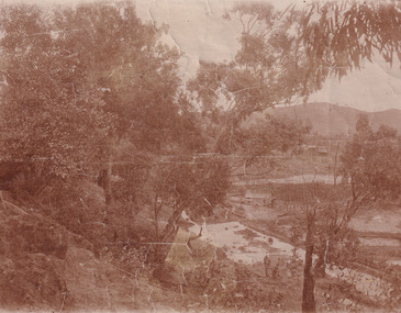
... Registers of historic buildings. Interestingly, the name El Dorado does not derive from the gold in the region, but from the Barambogie pastoral run completed by William Baker in 1840-1841. Gold was discovered in El Dorado 1854 but the gold was too deep for individual prospectors to find, it required the use of heavy machinery....Registers of historic buildings. Interestingly, the name El Dorado does not derive from the gold in the region, but from the Barambogie pastoral run completed by William Baker in 1840-1841. Gold was discovered in El Dorado 1854 but the gold was too deep for individual prospectors to find, it required the use of heavy machinery. ...The photo from 1907-8 is a sepia print, depicting a small valley with building at base. There are flumes visible above areas of water, trees on hills and a few small cottages on the hillside. Cock's Pioneer Gold & Tin Sluicing Co NZ No 2 Site. The photo was taken of Matthews Gully looking west. Sluicing was undertaken in the area from 1900 to 1942 with some short breaks between these periods. The image depicts a location mined by Cocks Pioneer Gold and Tin Sluicing Company (as recorded on the annotation on the card mount) The Cocks Pioneer Gold and Tin Mines N.L was one of El Dorado's two largest open cut sluicing mines of the 20th Century. The other was named the Cocks El Dorado Gold Dredging Company. The Cocks Pioneer Mines operated from 1901 until 1941 and found a total of 117,378 ounces of Gold and 1,673 tones of tin concentrates over these years. The Cocks company was formed in 1898 and operated until 1941. Open cut sluicing involved the use of high-powered hoses which used the centrifugal sand pump system (known as hydraulic sluicing) which broke down the soil which was then processed for gold and other precious metals. From 1914 , four years after this image was captured, the company reformed to Cocks Pioneer Gold and Tin Mines NL (previously it was known as Cocks Pioneer Sluicing Co) and undertook large scale sluicing operations until 1929 and then 1934-1941. El Dorado is located on Reedy Creek and is surrounded by forested country to the north and east. It is 20 km east of Wangaratta in Victoria's regional north-east. John Cock was the son of a Cornish minor who arrived in El Dorado in 1858. Cock founded his gold and tin mining company which ran successfully for many years in the El Dorado region. It was an open cut sluicing company because of the abandonment of underground mining after this was deemed too dangerous. In 1935 Cock's El Dorado Company commissioned the floating dredge which is still visible in El Dorado today. The dredge was built by the Thompson engineering works, Castlemaine, and weighed over 2,000 tones and today has a place on the Victorian Registers of historic buildings. Interestingly, the name El Dorado does not derive from the gold in the region, but from the Barambogie pastoral run completed by William Baker in 1840-1841. Gold was discovered in El Dorado 1854 but the gold was too deep for individual prospectors to find, it required the use of heavy machinery.The search for gold is ingrained into the history of Victoria and therefore, images like this one which portray an open cut sluicing site can reveal important information for society and technology for the date when the photograph was taken. This image is of important historical significance for its ability to convey information about sluicing and the methods used to find gold in 1910. It also shows a location where sluicing was undertook which provides insight into the impact of sluicing on the environment at a time when it was done. This image is important for current research into the history of El Dorado, a small regional location near Wangaratta in Victoria's North East. Therefore, this image has the capacity to be beneficial for research into society and the motivations of those living and working in this region during this period and therefore, has social significance. The Beechworth Burke Museum has additional images relating to gold sluicing and El Dorado which can be analysed and studied alongside images like this one.Sepia coloured rectangle photograph printed on gloss photographic paper Reverse: 1997. 2613/ A02613/ No2 site/ Matthews Gully/ Cocks Pioneer G&T. ?? Co NZ/ No2 Site looking West/ 1907-8/ (7)sluicing, hydraulic sluicing, 1907, 1908, mining, cock's pioneer gold & tin sluicing co nz, nz, site no 2, matthews gully, west, valley, building, cottages, hillside, trees, water, gold and tin mine -
 The Beechworth Burke Museum
Photograph, 1910 - 1911
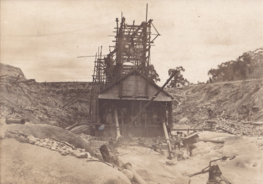
... Registers of historic buildings. Interestingly, the name El Dorado does not derive from the gold in the region, but from the Barambogie pastoral run completed by William Baker in 1840-1841. Gold was discovered in El Dorado in 1854 but the gold was too deep for individual prospectors to find, it required the use of heavy machinery....Registers of historic buildings. Interestingly, the name El Dorado does not derive from the gold in the region, but from the Barambogie pastoral run completed by William Baker in 1840-1841. Gold was discovered in El Dorado in 1854 but the gold was too deep for individual prospectors to find, it required the use of heavy machinery. ...This photograph depicts Cock's Pioneer G & T Sluicing site No. 4 in El Dorado. Looking eastwards, the photo captures a wooden and tin building with various mining equipment strewn in the foreground. Underneath the verandah, figures can be seen. These are believed to be a Mr. Hollister (left), Mrs. Breustedt (4th from left), children Min and Chris Breustedt, and Kate Timmons holding a girl's hand. The Cocks Pioneer Gold and Tin Mines N.L was one of El Dorado's two largest open-cut sluicing mines of the 20th Century. The other was named the Cocks El Dorado Gold Dredging Company. The Cocks Pioneer Mines operated from 1901 until 1941 and found a total of 117,378 ounces of Gold and 1,673 tones of tin concentrates over these years. The Cocks company was formed in 1898 and operated until 1941. Open cut sluicing involved the use of high-powered hoses which used the centrifugal sand pump system (known as hydraulic sluicing) which broke down the soil which was then processed for gold and other precious metals. From 1914, four years after this image was captured, the company reformed to Cocks Pioneer Gold and Tin Mines NL (previously it was known as Cocks Pioneer Sluicing Co) and undertook large-scale sluicing operations until 1929 and then 1934-1941. The Cocks Pioneer was an extremely successful mining company during the 20th century. In the Annual Report of the Secretary for Mines for the year 1915, the Cocks Pioneer was the largest producer of gold and tin collecting 5,535 ozs. of gold and £7,500 of tin. Twenty years later in 1935, Cocks Pioneer was still one of the most profitable mines in Victoria, ranking as the second-highest dividend paying mine. The company produced a total of 3,650 kg of gold. El Dorado is located on Reedy Creek and is surrounded by forested country to the north and east. It is 20 km east of Wangaratta in Victoria's regional northeast. John Cock was the son of a Cornish miner who arrived in El Dorado in 1858. Cock founded his gold and tin mining company which ran successfully for many years in the El Dorado region. It was an open-cut sluicing company because of the abandonment of underground mining after this was deemed too dangerous. In 1935 Cock's El Dorado Company commissioned the floating dredge which is still visible in El Dorado today. The dredge was built by the Thompson engineering works, Castlemaine, and weighed over 2,000 tones and today has a place on the Victorian Registers of historic buildings. Interestingly, the name El Dorado does not derive from the gold in the region, but from the Barambogie pastoral run completed by William Baker in 1840-1841. Gold was discovered in El Dorado in 1854 but the gold was too deep for individual prospectors to find, it required the use of heavy machinery.The search for gold is ingrained into the history of Victoria and therefore, images like this one which portray an open cut sluicing site can reveal important information for society and technology for the date when the photograph was taken. This image is of important historical significance for its ability to convey information about sluicing and the methods used to find gold in 1910. It also shows a location where sluicing was undertook which provides insight into the impact of sluicing on the environment at a time when it was done. This image is important for current research into the history of El Dorado, a small regional location near Wangaratta in Victoria's North East. Therefore, this image has the capacity to be beneficial for research into society and the motivations of those living and working in this region during this period and therefore, has social significance. The Beechworth Burke Museum has additional images relating to gold sluicing and El Dorado which can be analysed and studied alongside images like this one.A black and white copy of a sepia coloured rectangular photograph printed on matte photographic paper mounted on boardObverse: COCKS PIONEER G + T SL CO, N.L. / 1910 - 11 / NO 4 SITE LOOKING EAST / 4 Reverse: 1997.2508 / AUG 29 1909cocks pioneer gold and tin sluicing company, el dorado, mining, sluicing, hydraulic mining, hollister, breustedt, timmons, gold, tin, gold rush, victoria -
 The Beechworth Burke Museum
Photograph, 1910
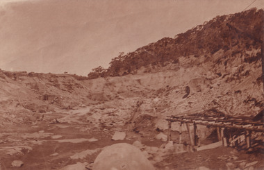
... Registers of historic buildings. Interestingly, the name El Dorado does not derive from the gold in the region, but from the Barambogie pastoral run completed by William Baker in 1840-1841. Gold was discovered in El Dorado 1854 but the gold was too deep for individual prospectors to find, it required the use of heavy machinery....Registers of historic buildings. Interestingly, the name El Dorado does not derive from the gold in the region, but from the Barambogie pastoral run completed by William Baker in 1840-1841. Gold was discovered in El Dorado 1854 but the gold was too deep for individual prospectors to find, it required the use of heavy machinery. ...This photograph dating to 1910 depicts an open cut sluicing site located in El Dorado captured looking east up the open cut from the number 3 Barge site. Sluicing was undertaken in the area from 1900 to 1942 with some short breaks between these periods. The image depicts a location mined by Cocks Pioneer Gold and Tin Sluicing Company (as recorded on the annotation on the card mount). It portrays open cut rocks with a crevice in the center of the image where the sluicing was being undertaken. There is a small timber structure on the right of the image which could be an entrance to a mine or supports made of wood to prevent a cave in at the open cut site and above the cut rock there is bush. The timber structure has rail tracks on top of the bridge which could suggest the identification of this structure as a mine entrance. The rail tracks were used for little carts which hauled soil from the mine. The Cocks Pioneer Gold and Tin Mines N.L was one of El Dorado's two largest open cut sluicing mines of the 20th Century. The other was named the Cocks El Dorado Gold Dredging Company. The Cocks Pioneer Mines operated from 1901 until 1941 and found a total of 117,378 ounces of Gold and 1,673 tones of tin concentrates over these years. The Cocks company was formed in 1898 and operated until 1941. Open cut sluicing involved the use of high-powered hoses which used the centrifugal sand pump system (known as hydraulic sluicing) which broke down the soil which was then processed for gold and other precious metals. From 1914 , four years after this image was captured, the company reformed to Cocks Pioneer Gold and Tin Mines NL (previously it was known as Cocks Pioneer Sluicing Co) and undertook large scale sluicing operations until 1929 and then 1934-1941. El Dorado is located on Reedy Creek and is surrounded by forested country to the north and east. It is 20 km east of Wangaratta in Victoria's regional north-east. John Cock was the son of a Cornish minor who arrived in El Dorado in 1858. Cock founded his gold and tin mining company which ran successfully for many years in the El Dorado region. It was an open cut sluicing company because of the abandonment of underground mining after this was deemed too dangerous. In 1935 Cock's El Dorado Company commissioned the floating dredge which is still visible in El Dorado today. The dredge was built by the Thompson engineering works, Castlemaine, and weighed over 2,000 tones and today has a place on the Victorian Registers of historic buildings. Interestingly, the name El Dorado does not derive from the gold in the region, but from the Barambogie pastoral run completed by William Baker in 1840-1841. Gold was discovered in El Dorado 1854 but the gold was too deep for individual prospectors to find, it required the use of heavy machinery.The search for gold is ingrained into the history of Victoria and therefore, images like this one which portray an open cut sluicing site can reveal important information for society and technology for the date when the photograph was taken. This image is of important historical significance for its ability to convey information about sluicing and the methods used to find gold in 1910. It also shows a location where sluicing was undertook which provides insight into the impact of sluicing on the environment at a time when it was done. This image is important for current research into the history of El Dorado, a small regional location near Wangaratta in Victoria's North East. Therefore, this image has the capacity to be beneficial for research into society and the motivations of those living and working in this region during this period and therefore, has social significance. The Beechworth Burke Museum has additional images relating to gold sluicing and El Dorado which can be analysed and studied alongside images like this one.Sepia coloured rectangular photograph printed on gloss photographic paper mounted on board.Obverse: COCKS PIONEER Q + T SL CO, N.L. / 1910 / LOOKING EAST UP OPEN CUT / FROM NO3 BARGE SITE / Reverse: 1997 . 2611 / A02611el dorado, north east gold, sluicing, gold sluicing, hydraulic sluicing, 1910, gold and tin mine, open cut mining, mining, gold mining, north-east victoria, beechworth, burke museum -
 Victorian Interpretive Projects Inc.
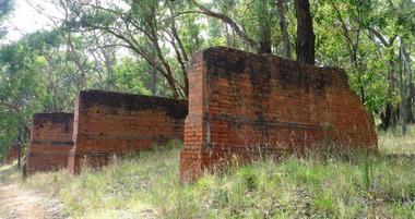
Photograph-colour, LJ Gervasoni, Jubilee Mine Scarsdale Victoria, 19/03/2011
... The machinery foundations are the remnants of large scale quartz mining operations carried on at the site between 1899 to 1912. During this time the mine produced over 125,000 ounces of gold and was the district's most important gold mine. (Source Victorian Heritage Register ...The Jubilee Mine at Scarsdale was started by Thomas Greenwood of Italian Gully.Jubilee Company Quartz Gold Mine has one of the most comprehensive range of quartz mining foundations in the State. The brick and concrete foundations cover pumping, winding and crushing operations, as well as cyaniding of mine tailings. The machinery foundations are the remnants of large scale quartz mining operations carried on at the site between 1899 to 1912. During this time the mine produced over 125,000 ounces of gold and was the district's most important gold mine. (Source Victorian Heritage Register http://vhd.heritage.vic.gov.au/vhd/heritagevic/?timeout=yes#detail_places;5517)colour photograph in digital format showing the brick foundations of the stamping plant at the Jubilee Mine in Scarsdale, Victoria.gold mine mining scarsdale -
 Bendigo Historical Society Inc.
Plan - Victoria Quartz Gold Mine
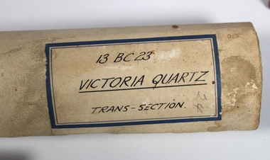
... As a postscript to the chronology of gold mining is the surviving crushing machinery (formerly part of the Bendigo Crushing Works) which was erected near the foundations of Lansell's 180 mine in 1932, to crush quartz for nearby mines. The place has a potential to yield artefacts and evidence which will be able to provide significant information about the technological history of gold mining. [Source: Victorian Heritage Register...As a postscript to the chronology of gold mining is the surviving crushing machinery (formerly part of the Bendigo Crushing Works) which was erected near the foundations of Lansell's 180 mine in 1932, to crush quartz for nearby mines. The place has a potential to yield artefacts and evidence which will be able to provide significant information about the technological history of gold mining. [Source: Victorian Heritage Register ...The Victoria Quartz Gold Mine was situated on Victoria Hill, Ironbark, (1877 - 1913). At the turn of the century, this was the site of one of the premier mines on the Bendigo goldfield. In 1908, it boasted the world's deepest shaft - 4,478 feet (1,365 metres). The shaft reached a depth of 4,613 feet (1,406 metres) in 1910. In 1857 eight small claims in this area had been merged to form the Victoria Reef Quartz Mining Co. Another merger in 1877 led to the formation of the Victoria Quartz Co. For the next three decades, the mine produced consistent profits. In 1910, water burst into the claim, flooding the shaft and halting operations. The company baled water for six months then handed the mine over to the tributers who worked the upper levels for the share of the profits. The mine closed in 1913, having produced over 48,000 ounces of gold and paid dividends of £99,600. (Source, Goldfield Guide https://www.goldfieldsguide.com.au/explore-location/400/victoria-hill-mining-reserve/) Victorian Heritage Register information on mine: Statement of Significance Last updated on - July 14, 2005 The story of quartz mining on Victoria Hill lies at the heart of Bendigo's historical status as the world's richest and deepest reefing field. Gold was discovered on Victoria Hill in 1854, and by early 1855 claims had been taken up over its entire extent. Shafts were first worked by windlass, whip or whim, and primitive crushing batteries were in operation. By 1861, Victoria Hill had yielded at least 1,200,000oz in gold. One of the early claims on Victoria Hill was owned by Prussian immigrants, Christopher Ballerstedt and his son Theodore. In 1854, they bought a claim on the hill for £80, to which they subsequently added other claims, and from the quartz veins (called spurs), worked both by shafts and a large open cut, obtained gold worth nearly £200,000. Christopher Ballerstedt was dubbed 'Father of the Hill' and has been credited as the first to debunk the theory at that time prevalent on the Bendigo field, that the gold content of reefs would diminish at depth. As his shafts plunged below the 200-foot level, the quartz remained rich in gold. His success inspired others, and so led the way to Bendigo's later status as the world's deepest and richest goldfield. The Ballerstedt's built Bendigo's grandest mansion, Fortuna. Theodore continued to work Victoria Hill after his father's death, but in 1871, convinced that his claim was exhausted, he sold both mine and mansion to George Lansell for £60,000. Lansell's mine on Victoria Hill was called the 180, and operated under his ownership until his death in 1906. The mine supplied the initial wealth that made Lansell Bendigo's 'Quartz King'. George Lansell was such a force in Bendigo's mining history that his death was cited as one of the reasons for the decline of Bendigo as a quartz mining centre, The Victoria Hill Quartz Gold Mines are of historical, archaeological and scientific importance to the State of Victoria. The Victoria Hill Quartz Gold Mines are historically significant as the symbolic heart of Bendigo's famous goldfield. The mines are linked to nineteenth-century individuals (Christopher Ballerstedt and George Lansell) who played prominent roles in the evolution of Bendigo. Both men's fortunes and their influence on Bendigo, originated from mining operations carried out on the hill. The Victoria Hill Quartz Gold Mines are historically and scientifically important as characteristic examples of an important form of gold mining. Gold mining sites are of crucial importance for the pivotal role they have played since 1851 in the development of Victoria. As well as being a significant producer of Victoria's nineteenth century wealth, quartz mining, with its intensive reliance on machinery, played an important role in the development of Victorian manufacturing industry. The Victoria Hill Quartz Gold Mines are important as a manifestation of this aspect of gold mining. The Victoria Hill Quartz Gold Mines are scientifically important, as they contain relics span nearly sixty years of mining (1854 to 1913), documenting the richest and most significant years of Bendigo's world-famous quartz mining industry. Enhancing the significance of the place are relics from the Victoria Quartz Company operations, ncluding, at 4,870 feet, the world's deepest nineteenth-century gold mining shaft. As a postscript to the chronology of gold mining is the surviving crushing machinery (formerly part of the Bendigo Crushing Works) which was erected near the foundations of Lansell's 180 mine in 1932, to crush quartz for nearby mines. The place has a potential to yield artefacts and evidence which will be able to provide significant information about the technological history of gold mining. [Source: Victorian Heritage Register] Hermes Number 8506 https://vhd.heritagecouncil.vic.gov.au/index.php/places/8506/download-report Hand drawn plan of the bottom section of the Victoria Quartz Gold Mine. Mine shaft shown from 2706 feet to 5200 (potential) feet shown, with annotation regarding geological features and gold obtained from different level crushings. Blue border sticker on outside of plan: '13 BC 23 Victoria Quartz Trans-Section'. Plan is not dated. The Victoria Quartz plan is part of the Margaret Roberts Collection.victoria hill quartz gold mine, victoria hill -
 Bendigo Historical Society Inc.
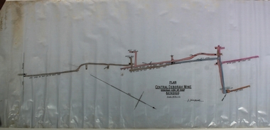
Plan - Central Deborah Gold Mine, J.J. Caldwell, 1945
... It was listed on the Victorian Heritage Register on 18 November 1999.[1] The mine was opened in 1939 by the Central Deborah Gold Mining Company during a 1930s revival of the gold industry, extending an existing 108 ft shaft from many years earlier with new machinery. ...It was listed on the Victorian Heritage Register on 18 November 1999.[1] The mine was opened in 1939 by the Central Deborah Gold Mining Company during a 1930s revival of the gold industry, extending an existing 108 ft shaft from many years earlier with new machinery. ...The Central Deborah Gold Mine is situated at 76 Violet Street, Bendigo. The mine operated from 1939 through to 1954 and extracted 929 kg of gold. The Central Deborah Gold Mine is a non-active gold mine and tourist attraction in Bendigo, Australia. It was listed on the Victorian Heritage Register on 18 November 1999.[1] The mine was opened in 1939 by the Central Deborah Gold Mining Company during a 1930s revival of the gold industry, extending an existing 108 ft shaft from many years earlier with new machinery. It was one of the last mines to open on the Bendigo goldfields and one of the few to stay open during World War II. It was expanded during 1945–46, with extensions and new machinery. It reached its maximum depth (now recorded as 412m) during the 1940s. It closed in November 1954, having produced 29,865 ounces of gold in its lifetime; the closure of the North Deborah Mine two weeks later marked the last mine in Bendigo to close Central Deborah Gold Mine is now a tourist destination, operated by Bendigo Heritage Attractions: https://www.central-deborah.com/about-us/central-deborah-gold-mine-s-history Blue waxed paper, features on plan drawn in pale pink and blue, title written in black text on centre bottom: 'Plan, Central Deborah Mine, Deborah Line of Reef, Bendigo, Scale 30 ft = 1 in.' Signature of J.J. Caldross, 13.10.45, written below name of mine. Handwritten on outside of plan in black pen: 'Mines Department, Cent. Deborah, Transverse section, Plan of levels' Plan notation shows No. 8 level on east leg of inner reef, level of east leg on outer reef, outer back, west leg, main shaft, numbers 5, 6, 7 and 10 levels. Mine map is part of the Margaret Roberts Collection. gold mining, gold, margaret roberts collection, central deborah gold mine, violet street, tourist attraction, bendigo -
 Flagstaff Hill Maritime Museum and Village
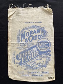
Textile - Flour bag - Moran & Cato's
... Machinery" and "with running water"). Flagstaff Hill Maritime Museum and Village Great Ocean Road Shipwreck Coast calico domestic object textile food storage Moran & Cato's flour bag self-raising flour Front - Wheaten Flour, Moran & Cato's, Trade mark The M & C Brand Registered, 7lbs Nett, The Highest Standard of Purity and Excellence, prepared with phosphate aerator, Self-raising Flour, For making scones bread cakes puddings & pastry, Warehouse & Office- Brunswick Street, Fitzroy, Melbourne Back - Moran & Cato's, Cleaned Fruits are Perfection, (advertising text), The Same High Quality, The Same Prices at all our Branches. ...The flour bag is an example of packaging from the grocery store, Moran & Cato's. Moran & Cato's were a large chain of grocery stores operating from the late nineteenth century to the mid twentieth century across Victoria, Tasmania and New South Wales. The address on the flour bag is for the warehouse (wholesale depot) of the business which was a significant building in Brunswick St, Fitzroy.The flour bag provides a snapshot of packaging for a well known grocery store of the early twentieth century. The advertisement on the back for 'Cleaned Fruits' is an example of advertising that highlighted important facts relevant to that time (e.g. "latest Special Machinery" and "with running water").Small calico flour bag for self-raising flour (7lb) supplied from Moran & Cato's in Brunswick Street, Fitzroy, Melbourne. The front of the bag includes not only the detail of the business but ideas for baking, images of wheat and claims as to its excellence. The back of the bag has a written advertisement for 'Cleaned Fruits' another product of the company.Front - Wheaten Flour, Moran & Cato's, Trade mark The M & C Brand Registered, 7lbs Nett, The Highest Standard of Purity and Excellence, prepared with phosphate aerator, Self-raising Flour, For making scones bread cakes puddings & pastry, Warehouse & Office- Brunswick Street, Fitzroy, Melbourne Back - Moran & Cato's, Cleaned Fruits are Perfection, (advertising text), The Same High Quality, The Same Prices at all our Branches.flagstaff hill maritime museum and village, great ocean road, shipwreck coast, calico, domestic object, textile, food storage, moran & cato's, flour bag, self-raising flour -
 Seaworks Maritime Museum
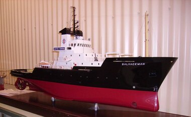
Shipbuilders model, MT Salvageman
... register (ESP flag, regd Bilbao, c/s EADY, 1597 GRT, 461 NRT) 1996: To "KTL - Klyne Tugs (Lowestoft) Ltd" at Lowestoft (GBR), renamed ANGLIAN PRINCE on base of case: "M.T. SALVAGEMAN/BUILT 1979 BY/ CHUNG WAH SHIPBUILDING & ENGINEERING CO LTD HONG KONG/ FOR/ UNITED TOWING LTD/ LENGTH O/A 68.25M BREADTH MLD 14.20M DEPTH MLD. 6.80M" On model: "SALVAGEMAN/ SALVAGEMAN HULL/ SALVAGEMAN HULL" Ship builder's model - Body of moulded polyurethane painted in maroon and black, the deck in colours of green and cream with detailed fittings, machinery, rigging and superstructure, raised on a wooden base. ...SALVAGEMAN of Hull (1980-) Owned by United Towing of Hull, she was the UK's largest and most powerful salvage tug for many years. In 1982 she saw service at the Falklands and played a part in the sinking and subsequent salvage of the Argentinian submarine Santa Fe. She was sold and renamed HISPANIA in 1991. Sold once again in 1996 and became the ANGLIAN PRINCE, a name that she still holds. 1977: Ordered and laid down as NOBLEMAN by "United Towing (Nobleman) Ltd", 1979 -12/07: Launched by "Chung Wah Shipbuilding & Engineering Co Ltd" at Hong Kong (HKG) (YN 160) 1980 -17/04: delivered to "UTC - United Towing Co (Howe) Ltd" at Hull (GBR) 1981 -16/03: mng "UTC - United Towing Co (Ocean Tugs) Ltd" at Hull (GBR), as SALVAGEMAN (GBR flag, regd Hull, ON 386484, c/s GXYN) 1987: taken over by "Howard Smith UK Ltd" at Hull (GBR) 1990 -24/04: To "Salvageman Ltd" at Douglas (IOM) 1991: To "COSMAR SA" (ESP), mng "Baluda Offshore" at Bilbao (ESP), renamed HISPANIA 1991 -25/7: British register closed and transferred to Spanish register (ESP flag, regd Bilbao, c/s EADY, 1597 GRT, 461 NRT) 1996: To "KTL - Klyne Tugs (Lowestoft) Ltd" at Lowestoft (GBR), renamed ANGLIAN PRINCEShip builder's model - Body of moulded polyurethane painted in maroon and black, the deck in colours of green and cream with detailed fittings, machinery, rigging and superstructure, raised on a wooden base. Ship was built by Chung Wah Shipbuilding & Engineering Co. on base of case: "M.T. SALVAGEMAN/BUILT 1979 BY/ CHUNG WAH SHIPBUILDING & ENGINEERING CO LTD HONG KONG/ FOR/ UNITED TOWING LTD/ LENGTH O/A 68.25M BREADTH MLD 14.20M DEPTH MLD. 6.80M" On model: "SALVAGEMAN/ SALVAGEMAN HULL/ SALVAGEMAN HULL" -
 Orbost & District Historical Society
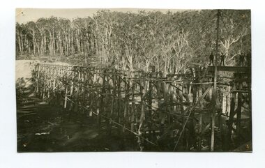
Photograph - Photograph. black + white
... Register of Historic Sites. Built of red ironbark and grey box timber, it is a fine example of the early engineering skills that utilised the resources and materials found on site. (More information Newsletter July 2013) Built during the period 1914-16, of Gippsland Grey Box and Red Ironbark, the Stoney Creek bridge on the East Gippsland Railway is a fine example of early engineering skilll , being constructed without the aid of any of the modern machinery available today. ...The Stony Creek Trestle Bridge was built in 1916 when the existing rail line from Melbourne to Bairnsdale was extended to Orbost. This 97km Bairnsdale to Orbost extension through rugged terrain was reputed to have been the most difficult rail project undertaken in Victoria. In service for over 60 years the bridge was damaged by bushfire in 1980, with the last train crossing in 1987. At 247m long and 20m high, it is the largest standing bridge of its kind in the State, and is listed on the Register of Historic Sites. Built of red ironbark and grey box timber, it is a fine example of the early engineering skills that utilised the resources and materials found on site. (More information Newsletter July 2013)Built during the period 1914-16, of Gippsland Grey Box and Red Ironbark, the Stoney Creek bridge on the East Gippsland Railway is a fine example of early engineering skilll , being constructed without the aid of any of the modern machinery available today. This is a rare photograph and of high significance in showing the bridge under construction.Landscape format black + white photograph (unframed). Four pin holes in each corner, tear to top left quadrant and fold / crease top to bottom in centre of image.construction, 1916, railway bridge, timber industry, trestle construction, stony creek bridge, east gippsland, bairnsdale to orbost line -
 Orbost & District Historical Society
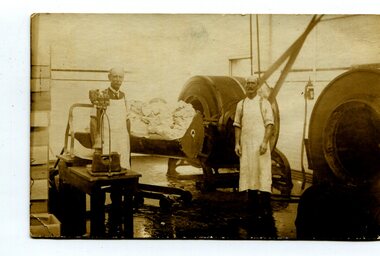
black and white photograph, C1900
... Ltd was registered on June 1st 1893 and was an important source of income to the Orbost district. orbost-butter-factory scouller-john dairying on back - " Orbost. m. Gilbert. J. Scouller, Fred?????. Donated by Colin Perry" A black / white photograph of two men standing near machinery ...This photograph shows Mr John Scouller, the manager, on the left with His assistant, Fred ?. Mr Scouller was the manager of the Orbost Butter Factory for 30 years and was succeeded by Mr Stafford after his retirement. The Orbost Butter and Produce Co. Ltd was registered on June 1st, 1892.The first shipment to England went rank and was only good for axle grease on wagons and carts.The milk was brought to the factory by horse and dray.Most people would take the whey home for their pigs,which were abundant on the farms in the Orbost district. First directors – James Nixon (chairman), James Cameron, Carl H. Grove, Harry Richardson, David Rhys Morris, Lachlan Ross. The factory opened 11th January, 1893 with John Scouller as the manager. The Orbost Butter and Produce Co. Ltd was registered on June 1st 1893 and was an important source of income to the Orbost district.A black / white photograph of two men standing near machinery inside the Orbost Butter Factory.on back - " Orbost. m. Gilbert. J. Scouller, Fred?????. Donated by Colin Perry"orbost-butter-factory scouller-john dairying -
 Flagstaff Hill Maritime Museum and Village
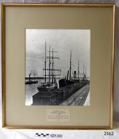
Photograph - Ships, South Warrnambool Primary School Centenary Committee, Unloading coal at Warrnambool Breakwater, 1977
... machinery. The image shows the early days at the Port of Warrnambool. The building of the Warrnambool Breakwater had only just been completed. Steamships and sailing ships were frequent visitors to the port. Steam Navigation companies were plentiful, carrying passengers and freighting cargo such as coal, timber, food, livestock, furniture, hardware and haberdashery between Melbourne and the ports along the southwest coast of Victoria, including Warrnambool. The carts would take their loads into the township for distribution. The ship carrying the coal is thought to be the "S.S. Chillagoe" previously named "Speculant". In 1903 the Chillagoe was registered...machinery. The image shows the early days at the Port of Warrnambool. The building of the Warrnambool Breakwater had only just been completed. Steamships and sailing ships were frequent visitors to the port. Steam Navigation companies were plentiful, carrying passengers and freighting cargo such as coal, timber, food, livestock, furniture, hardware and haberdashery between Melbourne and the ports along the southwest coast of Victoria, including Warrnambool. The carts would take their loads into the township for distribution. The ship carrying the coal is thought to be the "S.S. Chillagoe" previously named "Speculant". In 1903 the Chillagoe was registered ...This photograph was framed and mounted then presented to the South Warrnambool school by the South Warrnambool Centenary Committee in 1977 on the school's centenary year. The school was decommissioned and closed in the 1990s. In the photograph, people unload the coal from the ship beside the Breakwater and load it into the row of tramway carts. The coal would be sold to businesses and householders for the purpose of fuel for warmth, cooking, heating water and running machinery. The image shows the early days at the Port of Warrnambool. The building of the Warrnambool Breakwater had only just been completed. Steamships and sailing ships were frequent visitors to the port. Steam Navigation companies were plentiful, carrying passengers and freighting cargo such as coal, timber, food, livestock, furniture, hardware and haberdashery between Melbourne and the ports along the southwest coast of Victoria, including Warrnambool. The carts would take their loads into the township for distribution. The ship carrying the coal is thought to be the "S.S. Chillagoe" previously named "Speculant". In 1903 the Chillagoe was registered at the Port of Melbourne, and it sailed between Melbourne and Newcastle, New South Wales, where coal was mined and sold in significant quantities. In March 1890 a tragedy occurred when coal was being unloaded at the Warrnambool Breakwater. A local young man, David Ferrier, was working in the hold of the steamship Kurrara as its delivery of coal was being unloaded. A basket of coal fell from a sling onboard and came down upon Ferrier, breaking his back. He was not expected to live. In September 1890 there was a strike of coal workers but the Geelong Advertiser reported that a Warrnambool firm of coal merchants had recently received some large cargoes from Newcastle.The photograph is historically significant as it is connected with the local areas of the Warrnambool Breakwater, Lady Bay, and the South Warrnambool Primary School. The scene shows a moment in time when a steamship was unloading a shipment of coal onto tram carts on the Breakwater, which had only just been completed that year. The photograph was taken about 13 years after the opening of the South Warrnambool School, which was decommissioned around 20 years after it celebrated its centenary.. Photograph, black and white, in a gilded rectangular wooden frame, behind glass. The maritime scene shows figures on ships beside the Warrnambool Breakwater jetty and figures on the jetty, standing next to rail carts containing coal. There is a steamship further out on Lady Bay. A card below the photograph has an inscription and there is a pencil inscription on the back of the frame. The coal ship is thought to be the SS. Chillagoe. The photograph was taken in 1890 and was presented to the South Warrnambool School in its centenary year, 1977, by the South Warrnambool Centenary Committee.Typewritten on card: "UNLOADING COAL AT WARRNAMBOOL BREAKWATER"- 1890 - "Presented to Sough Warrnambool School by the SOUTH WARRNAMBOOL CENTENARY COMMITTEE - 1977 - " Handwritten in pencil on the back:"Speculant" as "SS Chillagoe" at Breakwater"flagstaff hill, warrnambool, maritime museum, maritime village, great ocean road, shipwreck coast, warrnambool breakwater, 1890, tramway, steamship, sailing ship, coal, cargo, port of warrnambool, unloading coal, chillagoe, speculant, newcastle, kurrana, david ferrier, coal strike -
 Flagstaff Hill Maritime Museum and Village
Ship Log, 1900-1920
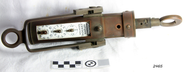
... machinery. It demonstrates the huge leap taken to improve navigational accuracy at sea with an instrument that was in use for decades. flagstaff hill warrnambool shipwrecked-coast flagstaff-hill flagstaff-hill-maritime-museum maritime-museum shipwreck-coast flagstaff-hill-maritime-village ship log rocket log mechanical ship log measuring instrument marine instrument nautical instrument speed recording instrument ship log register walker ship log walkers rocket ship-log thomas walker thomas walker & son thomas ferdinand walker walker log business reynolds ship log rotor taffrail log taff rail log west india association "Walkers Rocket Ship-Log Birmingham (Patented)" printed on face-plate. ...Thomas Walker & Son was internationally renowned in the manufacturing of ships logs. Founding father Thomas Walker (1805–1871), an engineer in Birmingham, patented a mechanical log in 1878 which was a recording instrument that attached to a rail at the stern of a vessel connected by a long cord with a rotor which was towed behind the ship. The instrument dial recorded the distance travelled. Thomas Walker first went into business to manufacture stoves at 58 Oxford Street Birmingham. Walker’s self-feeding stove was widely lauded at the Paris Exhibition of 1855, winning a prize medal and kick starting the first of many notable innovations for the Walker family's manufacturing business. However, it wasn’t until working on an earlier ships log model invented by his Uncle that Thomas Walker became interested in the further development of this device, used to ascertain a ship’s speed. Walker continued to improve on the common log for the company of Massey & Sons and these improvements were deemed revolutionary. This log became a firm favourite of the West India Association (British-based organisation promoting ties and trade with the British Caribbean) and the most common log in use for two generations. It took till 1861 for Thomas Walker and his son, Thomas Ferdinand Walker (1831-1921) to patent the first Walker log of many. Together, with the introduction of the A1 Harpoon Log two years later, they established the Walker Log Business as a force to be reckoned with. By the time of his passing in 1871, Thomas Walker Snr had not only founded a family business with considerable staying power but also instilled a tradition of public service. Having sat as a representative on the Birmingham Town Council for 15 years and played an active role in public works, he was soon given the nickname of ‘Blue Brick Walker’. Much like his father, Thomas Ferdinand Walker changed the face of the maritime industry. His patent of 1897, the ‘Cherub’ log, was a notable departure from the past providing a far more accurate reading and replacing the majority of logs of the age. They were the first to produce an electric log and the Walker factory was one of the first to introduce the 48 hour work week for employees. This ship log was invented and made by a significant marine instrument maker and innovator of machinery. It demonstrates the huge leap taken to improve navigational accuracy at sea with an instrument that was in use for decades. Ship Log, three analogue dials calibrated in increments of Miles, the Rocket Log is a nautical instrument for measuring a vessel’s speed and distance traveled. The floating log was drawn behind the ship over a fixed time period in order to measure the distance traveled. The counter could measure enough miles to cover the maximum distance traveled by a ship in one day. The log has two distinct parts; a brass register, made by Walker, showing the distance recorded and the rotator made by Reynolds, that spins in the water driving the counter. both parts are connected by a linked chain. The register has a cylindrical brass body approx 4.5 cm diameter containing registering mechanism with hardened steel bearings. Distance is indicated by the three pointers on enamel plate as follows: graduated every 10 miles from 0-100; every mile from 1-10; every 1/4 mile from 1/4 -1. A brass sling and eye secured to the body enables it to be attached to the taffrail. The original rotator would have had a cylindrical tapered wooden body, approx 4.5 cm in diameter with three metal alloy fins or could be all made from brass. A towing eye is fitted to the tapered end. The two pieces of apparatus are connected by a length of linked chain, length 22.9 cm."Walkers Rocket Ship-Log Birmingham (Patented)" printed on face-plate. "Made by Thomas Walker".flagstaff hill, warrnambool, shipwrecked-coast, flagstaff-hill, flagstaff-hill-maritime-museum, maritime-museum, shipwreck-coast, flagstaff-hill-maritime-village, ship log, rocket log, mechanical ship log, measuring instrument, marine instrument, nautical instrument, speed recording instrument, ship log register, walker ship log, walkers rocket ship-log, thomas walker, thomas walker & son, thomas ferdinand walker, walker log business, reynolds ship log rotor, taffrail log, taff rail log, west india association -
 Flagstaff Hill Maritime Museum and Village
Ship Log, 1900-1920
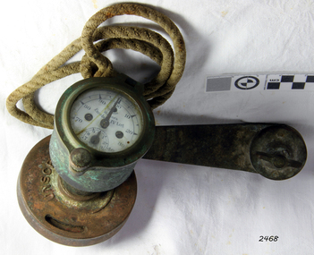
... machinery. It demonstrates the huge leap taken to improve navigational accuracy at sea with an instrument that was in use for decades. flagstaff hill warrnambool shipwrecked-coast flagstaff-hill flagstaff-hill-maritime-museum maritime-museum shipwreck-coast flagstaff-hill-maritime-village log register taff rail log taffrail log marine navigation a1 harpoon log cherub’ log walker’s excelsior mark iv log ship’s log instrument mechanical ship’s log measure ship’s speed nautical instrument navigation instrument massey & sons thomas walker blue brick walker thomas walker & son thomas ferdinand walker 48 hour work week "Walker's Excelsior IV Log", "Made in England by Thomas Walker, Birmingham" Ship's Taff Rail Log, rope attached. ...The Excelsior IV Log is a nautical instrument for measuring a vessel’s speed and distance travelled. When navigating a ship it is essential to be able to estimate the boat’s speed and distance travelled to determine its position at sea. In times past the only way to measure a ship’s speed was to throw a wood log into the water and observe how fast it moved away from the ship. In the 16th century, the log was fastened to a rope knotted at set intervals. The log was thrown over the stern (back) of the vessel and a crew member counted the number of knots that were paid out in a set time. From this, they could estimate the speed of the vessel through the water. This was known as streaming the log and is also the derivation of the knot as a measurement of nautical speed. The Walker’s Excelsior Mark IV instrument was designed for smaller vessels, such as yachts, launches and fishing vessels. Historical: Thomas Walker & Son was internationally renowned in the manufacturing of ships logs, founding father , Thomas Walker (1805–1871), an engineer in Birmingham, patented a mechanical log in 1878 which was a recording instrument that attached to a rail at the stern of a vessel connected by a long cord with a rotor which was towed behind the ship. The instrument dial recorded the distance travelled. Thomas Walker first went into business to manufacture stoves at 58 Oxford Street Birmingham. Walker’s self-feeding stove was widely lauded at the Paris Exhibition of 1855, winning a prize medal and kick starting the first of many notable innovations for the Walker family's manufacturing business. However, it wasn’t until working on an earlier ship’s log model invented by his Uncle that Thomas Walker became interested in the further development of this device, used to ascertain a ship’s speed. Walker continued to improve on the common log for the company of Massey & Sons and these improvements were deemed revolutionary. This log became a firm favourite of the West India Association (British-based organisation promoting ties and trade with the British Caribbean), being the most common log in use for two generations. It took until 1861 for Thomas Walker and his son, Thomas Ferdinand Walker (1831-1921) to patent the first Walker log of many. Together, with the introduction of the A1 Harpoon Log two years later, they established the Walker Log Business as a force to be reckoned with. By the time of his passing in 1871, Thomas Walker Snr had not only founded a family business with considerable staying power but also instilled a tradition of public service. Having sat as a representative on the Birmingham Town Council for 15 years and played an active role in public works, he was soon given the nickname of ‘Blue Brick Walker’. Much like his father, Thomas Ferdinand Walker changed the face of the maritime industry. His patent of 1897, the ‘Cherub’ log, was a notable departure from the past providing a far more accurate reading and replacing the majority of logs of the age. They were the first to produce an electric log and the Walker factory was one of the first to introduce the 48 hour work week for employees. The ship log was invented and made by a significant marine instrument maker and innovator of machinery. It demonstrates the huge leap taken to improve navigational accuracy at sea with an instrument that was in use for decades.Ship's Taff Rail Log, rope attached. Walker's Excelsior IV Log model. Nautical miles dials: units and 10's. "Walker's Excelsior IV Log", "Made in England by Thomas Walker, Birmingham"flagstaff hill, warrnambool, shipwrecked-coast, flagstaff-hill, flagstaff-hill-maritime-museum, maritime-museum, shipwreck-coast, flagstaff-hill-maritime-village, log register, taff rail log, taffrail log, marine navigation, a1 harpoon log, cherub’ log, walker’s excelsior mark iv log, ship’s log instrument, mechanical ship’s log, measure ship’s speed, nautical instrument, navigation instrument, massey & sons, thomas walker, blue brick walker, thomas walker & son, thomas ferdinand walker, 48 hour work week -
 Flagstaff Hill Maritime Museum and Village
Tool - Ship Taffrail Log Flywheel, 1930+
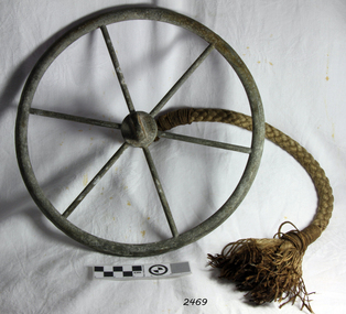
... register on the indicator, thus measuring the distance the vessel had travelled. Thomas Ferdinand Walker (1837–1921) first patented the Cherub log in 1878. It was one of the first logs in which the recorder was placed onboard a ship rather than being incorporated as part of the rotor. The Cherub Mark III series was produced from 1930 it came in two versions a thousand-mile which is quite rare and a five hundred-mile version. This ship log flywheel was invented and made by a significant marine instrument maker and innovator of machinery ...The flywheel possibly belongs to a Walker's Cherub Mark III Ship-log taffrail, how the flywheel operates is a metal loop of the recording log would have been connected to the flywheel, so you could see if it was spinning properly. After the flywheel, is the rotor that was towed behind the ship and the revolutions of the rotor would register on the indicator, thus measuring the distance the vessel had travelled. Thomas Ferdinand Walker (1837–1921) first patented the Cherub log in 1878. It was one of the first logs in which the recorder was placed onboard a ship rather than being incorporated as part of the rotor. The Cherub Mark III series was produced from 1930 it came in two versions a thousand-mile which is quite rare and a five hundred-mile version.This ship log flywheel was invented and made by a significant marine instrument maker and innovator of machinery Thomas Walker. It demonstrates the huge leap taken to improve navigational accuracy at sea with an instrument that was in use for decades to measure the distance travelled at sea updated versions are in use today by mariners.Log Governor (or Fly-wheel) from a Ships Taffrail Log, metal wheel with 6 spokes, hub has rope attached for connecting to ships log. Boss the other side for attachment to the spinner.Noneflagstaff hill, warrnambool, shipwrecked-coast, flagstaff-hill, flagstaff-hill-maritime-museum, maritime-museum, shipwreck-coast, flagstaff-hill-maritime-village, log governor -
 Sunshine and District Historical Society Incorporated
Photograph - Black Powder Mill
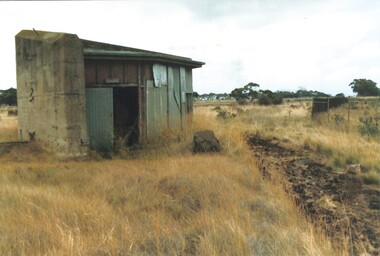
... . - Restoration: Added to the National Trust Register in 2001; restored and reopened in 2003. - Today: - Hosts annual open days with machinery demonstrations and black powder firearm displays. - Managed by the Sunshine & District Historical Society since 2022. ...This is an early photograph of the Black Powder Mill after the Explosive Factory was closed down, but before any restoration work took place and it was placed on the Voctorian Heritage List.Black Powder Mill (Building No. 745) - Built: 1942, to supplement output from the nearby ICIANZ plant (operating since 1935). - Function: Ground gunpowder for bombs and shells using an edge-runner mill—a technology dating back to the 16th century. - Design: - Two levels: milling equipment above, mechanical gear below. - Reinforced concrete walls and sacrificial wooden blast doors directed explosions safely toward Kororoit Creek. - Incident: In 1944, an explosion injured two workers; one later died from burns. Heritage and Preservation - Significance: - Only surviving building from the Albion Explosives Factory. - Possibly the last gunpowder production building erected for military use worldwide. - Recognized for its engineering, historical, and social importance. - Saved by Community: Initially slated for demolition, but preserved after strong local advocacy. - Restoration: Added to the National Trust Register in 2001; restored and reopened in 2003. - Today: - Hosts annual open days with machinery demonstrations and black powder firearm displays. - Managed by the Sunshine & District Historical Society since 2022. black powder mill, deer park, explosive factory, cairnlea, icianz, ici -
 Bendigo Historical Society Inc.
Photograph - Victoria Hill, Bendigo, 1973
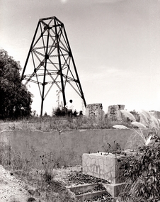
... machinery and the foundations of George Lansell’s 180 mine. These features are characteristic of Bendigo’s mining history and represent two prominent nineteenth century miners, Christopher Ballerstedt and George Lansell, who held important roles in the development of Bendigo. Victoria Hill Quartz Gold Mines are registered...machinery and the foundations of George Lansell’s 180 mine. These features are characteristic of Bendigo’s mining history and represent two prominent nineteenth century miners, Christopher Ballerstedt and George Lansell, who held important roles in the development of Bendigo. Victoria Hill Quartz Gold Mines are registered ...Gold was discovered on Victoria Hill in 1854 and by 1861, 1,200,000 ounces of gold had been extracted from the site. The first claim was bought for 80 pounds by Prussian immigrant Christopher Ballerstedt and his son Theodore. Christopher Ballerstedt was nicknamed the "Father of the Hill" and was the first to prove that gold reefs extended below the surface. His 200-foot plus mine shafts yielded quartz rich with gold, inspired other miners, and were instrumental in Bendigo becoming the world's deepest and richest goldfield. The site still features relics of nineteenth century mining including quartz crushing machinery and the foundations of George Lansell’s 180 mine. These features are characteristic of Bendigo’s mining history and represent two prominent nineteenth century miners, Christopher Ballerstedt and George Lansell, who held important roles in the development of Bendigo. Victoria Hill Quartz Gold Mines are registered as a site of significance. The site is of historical, archaeological and scientific importance to Victoria. The mines represent the symbolic heart of Bendigo’s gold mining history and the importance that mining played in wealth creation and the development of Victoria. The diggings reserve is accessed from the rear of Albert Richardson Reserve located at 40-56 Marong Road, Ironbark. The site has steep and unformed paths and is closed to the public at dusk. It is important to stay to the paths to avoid the diggings. Interpretive signs help visitors to appreciate the importance of the site and the remaining relics of Bendigo’s mining history.Victoria Hill Ironbark, Bendigo. Photos of the poppet head, sand heap, tailings, shafts and tunnels. Before development into a tourist attraction.history, bendigo, victoria hill, ironbark, diggings -
Linton and District Historical Society Inc
Mining company registration form, Good Hope Company
... machinery". Information about the Good Hope company includes mining registration numbers (213 and 214), date of registration (24th May 1862, for both registrations), class of mining, extent of claim, location, names of shareholders and their mining right numbers, and transfers of share ownership which have taken place. Gold mining Mining companies Court of Mines Registration forms Shareholders Good Hope Company Hugh Taylor Cochrane John Main (Mayne?) Andrew McKay Ralph Walton William Wenmouth (Weymouth?) John Renwick Joseph Bachelor John Ferguson Documents and records Mining company registers ...The page lists information about the Good Hope gold mining company at Black Lead, 'Old Linton'. There is also a separate registration for an "area for machinery". Information about the Good Hope company includes mining registration numbers (213 and 214), date of registration (24th May 1862, for both registrations), class of mining, extent of claim, location, names of shareholders and their mining right numbers, and transfers of share ownership which have taken place.A3 size photocopy of a page which has probably come from a register of mining companies, most likely maintained at the Smythesdale Court of Mines or another local Court of Mines. (The actual source of the document is not known.) The page is numbered "58" at the top left.gold mining, mining companies, court of mines, registration forms, shareholders, good hope company, hugh taylor cochrane, john main (mayne?), andrew mckay, ralph walton, william wenmouth (weymouth?), john renwick, joseph bachelor, john ferguson, documents and records, mining company registers -
 Puffing Billy Railway
Functional object - Billabong Ram Pump Size #5, Unknown
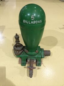
... registered in Victoria on 25 January 1889 to continue the hardware manufacturing and supply business founded by brothers John and Samuel Danks in 1859. The head office was based in Bourke Street, Melbourne while another branch was established in Sydney in the 1880s. The company had factories in Melbourne and Sydney. The John Danks and Son Limited catalogue published in 1890, listing Billabong Hydraulic Rams as one of its major machinery...registered in Victoria on 25 January 1889 to continue the hardware manufacturing and supply business founded by brothers John and Samuel Danks in 1859. The head office was based in Bourke Street, Melbourne while another branch was established in Sydney in the 1880s. The company had factories in Melbourne and Sydney. The John Danks and Son Limited catalogue published in 1890, listing Billabong Hydraulic Rams as one of its major machinery ...Pump - Billabong Ram Pump Size #5 Based on available historical data, the Australian-made Billabong Hydraulic Ram is one of the oldest rams produced anywhere in the world The Billabong Hydraulic Ram was first introduced into Australia in 1855 by John Danks and Son Limited, John Danks & Son Pty Ltd began as a plumbing business in 1859, established by brothers John and Samuel. It occupied a prominent site in Bourke Street, Melbourne, for 100 years. The business quickly grew to include factories in Melbourne and Sydney which manufactured and supplied a variety of plumbing and engineering products such as brassware, pumps, windmills and bells. The company was registered in Victoria on 25 January 1889 to continue the hardware manufacturing and supply business founded by brothers John and Samuel Danks in 1859. The head office was based in Bourke Street, Melbourne while another branch was established in Sydney in the 1880s. The company had factories in Melbourne and Sydney. The John Danks and Son Limited catalogue published in 1890, listing Billabong Hydraulic Rams as one of its major machinery products. The catalogue also provides reference to the company’s ram experience and manufacture, beginning by stating that in 1890 they already had 35 years of experience with Billabong Hydraulic Rams. The Hydraulic Ram has stood the test of time and it remains one of the few really practical and efficient uses of natural energy today. It operates without almost any cost, will last indefinitely and, with only two moving parts, is simplicity itself. It requires minimum maintenance and minimum replacement of parts. It is not uncommon to find rams working continuously for many years without any attention. • The Rams do not require electricity, fuel or steam to operate. • They possess simplicity of construction and operation – only 2 moving parts. • Powered only by running water. • Require very minimal or almost no maintenance. • Heavy duty cast Iron base and Dome. This Pump recovered from the Clematis Creek in the Mid 1970's Used to pump water from the creek to the Paradise (Clematis) Hotel. Historic - Farm Equipment - Used to pump water from the creek to the Paradise (Clematis) Hotel.Cast Iron Bronze valveBillabong 5billabong, puffing billy, ram pump -
 Bendigo Historical Society Inc.
Document - Gasworks Vision Workshop, 2015
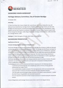
... The significance of the site (Victorian Heritage Register Statement of Significance) and the challenges of re-developing the site for tourism are listed for discussion. 2. One page photocopy of the Statement of Significance of the Bendigo Gasworks Conservation Analysis. The gasworks complex, plant and machinery...The significance of the site (Victorian Heritage Register Statement of Significance) and the challenges of re-developing the site for tourism are listed for discussion. 2. One page photocopy of the Statement of Significance of the Bendigo Gasworks Conservation Analysis. The gasworks complex, plant and machinery ...The Bendigo Gas Works are one of around three remaining intact 19th century gas works in the world, and the only one in Australia. It is on the Victorian Heritage Register and regarded by Institution of Engineers Australia as an internationally significant example of an entire provincial gasworks The Bendigo Gasworks operated from 1860 until 1973 when natural gas was introduced and remain as they were at the time of closure; a treasure of industrial heritage frozen in time. It is an internationally significant example of an entire provincial gasworks. It has the only horizontal gas-producing retorts in Australia. Coal Gas was manufactured here from 1860 and operated continuously until the introduction of natural gas in 1973. The works were operated by the Bendigo Gas Company until purchased by the Gas and Fuel Corporation in 1958 at which time they were supplying 3,500 consumers. During the Second World War the works were expanded by the Ministry of Munitions to serve the Bendigo Ordinance Factory. The original works were constructed during 1859-1860 under the direction of engineer Alexander Kennedy Smith (1824 - 1881) and developed in a period of growth by W. A. Simco, General Manager 1922-1939. ( Engineering Heritage Australia: ttps://heritage.engineersaustralia.org.au/wiki/Place:Bendigo_Gas_Works) The site is on the Victorian Heritage Register (VHR) Number H0781 1. Five page, double sided document, typed with photos, prepared by the City of Greater Bendigo, 23rd October 2015. . Heading on front page ' Gasworks Vision Workshop, Heritage Advisory Committee, City of Greater Bendigo'. 'Draft' written across each page. The significance of the site (Victorian Heritage Register Statement of Significance) and the challenges of re-developing the site for tourism are listed for discussion. 2. One page photocopy of the Statement of Significance of the Bendigo Gasworks Conservation Analysis. The gasworks complex, plant and machinery, historic associations of the Gasworks and landscape are assessed. sandhurst, bendigo, gas works, heritage listing, tourism, entertainment, science and engineering, bendigo city council, retorts, coal -
 Bendigo Historical Society Inc.
Plan - Bendigo Gasworks, Unknown
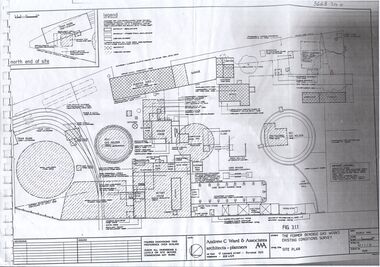
... Register (VHR) Number H0781 Sandhurst Bendigo Gas works heritage listing tourism science and engineering Bendigo City Council retort 1. One page A3 photocopy of site plan of the former Bendigo Gas Works Existing Conditions Survey, by Andrew C. Ward & Associates, architects and planners. Plan shows location of all items of plant in the Gas Works 2. One page photocopy, headed 'Functional Arrangement of Plant' showing the major functional items of plant, machinery ...The Bendigo Gas Works are one of around three remaining intact 19th century gas works in the world, and the only one in Australia. It is on the Victorian Heritage Register and regarded by Institution of Engineers Australia as an internationally significant example of an entire provincial gasworks The Bendigo Gasworks operated from 1860 until 1973 when natural gas was introduced and remain as they were at the time of closure; a treasure of industrial heritage frozen in time. It is an internationally significant example of an entire provincial gasworks. It has the only horizontal gas-producing retorts in Australia. Coal Gas was manufactured here from 1860 and operated continuously until the introduction of natural gas in 1973. The works were operated by the Bendigo Gas Company until purchased by the Gas and Fuel Corporation in 1958 at which time they were supplying 3,500 consumers. During the Second World War the works were expanded by the Ministry of Munitions to serve the Bendigo Ordinance Factory. The original works were constructed during 1859-1860 under the direction of engineer Alexander Kennedy Smith (1824 - 1881) and developed in a period of growth by W. A. Simco, General Manager 1922-1939. ( Engineering Heritage Australia: ttps://heritage.engineersaustralia.org.au/wiki/Place:Bendigo_Gas_Works) The site is on the Victorian Heritage Register (VHR) Number H0781 1. One page A3 photocopy of site plan of the former Bendigo Gas Works Existing Conditions Survey, by Andrew C. Ward & Associates, architects and planners. Plan shows location of all items of plant in the Gas Works 2. One page photocopy, headed 'Functional Arrangement of Plant' showing the major functional items of plant, machinery and equipment at the Bendigo Gasworks for the period 1930 - 1965. sandhurst, bendigo, gas works, heritage listing, tourism, science and engineering, bendigo city council, retort
