Showing 372 items matching "reservoir road"
-
 Box Hill Historical Society
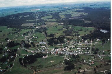
Photograph - Aerial view of the reservoir in Canterbury Road
... Aerial view of the reservoir in Canterbury Road...Aerial view of the reservoir in Canterbury Road. The photo is looking south over Surrey Hills and the telecommunication tower....Aerial photographs Canterbury Road Surrey Hills Telecommunications equipment Photograph Aerial view of the reservoir in Canterbury Road ...Aerial view of the reservoir in Canterbury Road. The photo is looking south over Surrey Hills and the telecommunication tower.aerial photographs, canterbury road, surrey hills, telecommunications equipment -
Stawell Historical Society Inc
Photograph, Water storage tanks part of reservoir in reefs road -- Coloured
... Water storage tanks part of reservoir in reefs road -- Coloured...Coloured Photo showing two water storage tanks part of reservoir in reefs road...Water storage tanks part of reservoir in reefs road -- Coloured Photograph ...Coloured Photo showing two water storage tanks part of reservoir in reefs roadDirt road in foreground power pole and water tanks. stawell -
 Bendigo Military Museum
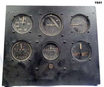
Equipment - INSTRUMENT PANEL RAAF, Early WW2
... "M Matheson 87 Reservoir Road Strathdale Bendigo" (Label on rear)....Instruments equipment RAAf "M Matheson 87 Reservoir Road Strathdale Bendigo" (Label on rear). ...Belonged to Maxwell Lennox Matheson 418447 RAAF. Refer 1959 for his service history.Wood frame block with six (6) instruments, round shape set in the wood frame. The 6 instruments all different all represent a replica of a standard "sperry flight instrument panel". These parts were fitted to most RAF and RAAF aircraft. "M Matheson 87 Reservoir Road Strathdale Bendigo" (Label on rear).instruments, equipment, raaf -
 Linton and District Historical Society Inc
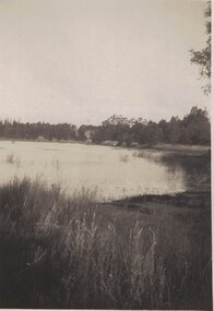
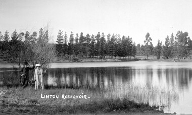
Photograph, Linton Reservoir from Mortchup Road, undated
... Linton Reservoir from Mortchup Road, undated...Linton Reservoir from Mortchup Road, undated Photograph ...Small black and white image of a waterway.linton reservoir -
Box Hill Historical Society
Photograph - Box Hill Reservoir, 1908-1910
... Construction of Box Hill Reservoir, corner of Canterbury Road and Elgar Roads 1908-1910. ...On back of original photograph - CONSTRUCTION OF BOX HILL RESERVOIR ELGAR ROAD 1908-1910....Box Hill Reservoir Dams and reservoirs Muldoon> Owen On back of original photograph - CONSTRUCTION OF BOX HILL RESERVOIR ELGAR ROAD 1908-1910. B&w photo Photograph Box Hill Reservoir ...Construction of Box Hill Reservoir, corner of Canterbury Road and Elgar Roads 1908-1910. Owen Muldoon was a contractor who lived in Brougham Street, Box Hill, and kept around 14 horses in an adjacent paddock. Donor identifies as Box Hill Reservoir but it has been queried.B&w photoOn back of original photograph - CONSTRUCTION OF BOX HILL RESERVOIR ELGAR ROAD 1908-1910.box hill reservoir, dams and reservoirs, muldoon> owen -
 Eltham District Historical Society Inc
Document, Objection by P. and C. Vermey to Application Ref. No. E94/306 - proposed subdivision Melbourne Water Reservoir & Pumping Station - Diosma Road, Eltham, 1 September 1994, 1/9/1994
... E94/306 - proposed subdivision Melbourne Water Reservoir & Pumping Station - Diosma Road, Eltham, 1 September 1994...Road...Letter of objection...Melbourne Metropolitan Board of Works...Planning Application...Reservoir...E94/306 - proposed subdivision Melbourne Water Reservoir & Pumping Station - Diosma Road, Eltham, 1 September 1994 Document ...The Stokes Orchard Estate collection is typical of housing developments of the late 1970s and 1980s. It was one of the earliest estates in Eltham following the nearby Woodridge Estate development.A4 letter and five accompanying supporting pagesAs notedstokes place, eltham, stokes orchard, stokes orchard estate, streets, houses, peter and carla vermey, diosma road, letter of objection, melbourne metropolitan board of works, planning application, reservoir, shire of eltham -
 Hume City Civic Collection
Photograph, early 1980s
... ...reservoir road...The settlement at this stage extended along either side of Gap Road for about 0.5 km beyond Elizabeth Drive. sunbury township reservoir road mt. holden sunbury asylum george evans collection A coloured landscape photograph with rounded corners taken from Mt. ...The photograph shows the extent of Sunbury's development to the west of the town in the early 1980s. The settlement at this stage extended along either side of Gap Road for about 0.5 km beyond Elizabeth Drive.A coloured landscape photograph with rounded corners taken from Mt. Holden and looking towards the expanding town of Sunbury. The Melba Avenue drain which flows into Blind Creek is in the foreground. Sheoak Hill, the site of the former Sunbury Asylum is in the middle of the skyline.sunbury township, reservoir road, mt. holden, sunbury asylum, george evans collection -
 Linton and District Historical Society Inc
Photograph, Hornby Studios, Clunes, Unidentified couple at Linton Reservoir
... Linton Reservoir (Mortchup Road Reservoir)...Linton and District Historical Society Inc 69 Sussex Street Linton 3360 goldfields Linton Reservoir (Mortchup Road Reservoir) Black and white photograph which has been made into a postcard, showing a lady wearing long dress, coat and hat, and gentleman in suit and hat, posing for a photograph at Linton reservoir. ...Black and white photograph which has been made into a postcard, showing a lady wearing long dress, coat and hat, and gentleman in suit and hat, posing for a photograph at Linton reservoir. The words "LINTON RESERVOIR" are printed across the lower left of the postcard.linton reservoir (mortchup road reservoir) -
 Linton and District Historical Society Inc
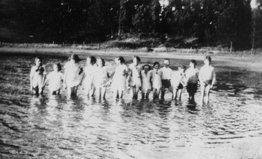
Photograph, Group of Children at Linton Reservoir
... Linton Reservoir (Mortchup Road Reservoir)...Linton and District Historical Society Inc 69 Sussex Street Linton 3360 goldfields Linton Reservoir (Mortchup Road Reservoir) Reverse: " Linton / RESERVOIR. ...Small black and white photograph of 13 children standing in a body of water. The children are identified by inscription as members of McCorkell and Fletcher families.Reverse: " Linton / RESERVOIR. OUT OF BOUNDS / McCORKELL & FLETCHER FAMILY / PLUS ?? ".linton reservoir (mortchup road reservoir) -
Box Hill Historical Society
Photograph - Box Hill Reservoir, 1908-1910
... Construction of Box Hill Reservoir, corner of Canterbury and Elgar Roads. 1908-1910. See further information on B0226....CONSTRUCTION OF BOX HILL RESERVOIR ELGAR ROAD 1908-1910....CONSTRUCTION OF BOX HILL RESERVOIR ELGAR ROAD 1908-1910. B&w photo Photograph Box Hill Reservoir ...Construction of Box Hill Reservoir, corner of Canterbury and Elgar Roads. 1908-1910. See further information on B0226.B&w photoOn back of original photograph. CONSTRUCTION OF BOX HILL RESERVOIR ELGAR ROAD 1908-1910.box hill reservoir, dams and reservoirs, muldoon> owen -
Box Hill Historical Society
Photograph - Box Hill Reservoir, 1908-1910
... Construction of Box Hill Reservoir, corner of Canterbury and Elgar Roads, 1908--1910. See further information on this series on B0226....On back of original photograph - CONSTRUCTION OF BOX HILL RESERVOIR ELGAR ROAD 1908-1910....Box Hill Reservoir Dams and reservoirs Muldoon> Owen On back of original photograph - CONSTRUCTION OF BOX HILL RESERVOIR ELGAR ROAD 1908-1910. B&w photo Photograph Box Hill Reservoir ...Construction of Box Hill Reservoir, corner of Canterbury and Elgar Roads, 1908--1910. See further information on this series on B0226.B&w photoOn back of original photograph - CONSTRUCTION OF BOX HILL RESERVOIR ELGAR ROAD 1908-1910.box hill reservoir, dams and reservoirs, muldoon> owen -
 Box Hill Historical Society
Photograph - Box Hill Reservoir, 1908-1910
... Construction of Box Hill Reservoir, corner of Canterbury and Elgar Roads, 1908-1910. See further details on B0226....On back of original photograph - CONSTRUCTION OF BOX HILL RESERVOIR ELGAR ROAD 1908-1910....Box Hill Reservoir Dams and reservoirs Muldoon> Owen On back of original photograph - CONSTRUCTION OF BOX HILL RESERVOIR ELGAR ROAD 1908-1910. B&w photo Photograph Box Hill Reservoir ...Construction of Box Hill Reservoir, corner of Canterbury and Elgar Roads, 1908-1910. See further details on B0226.B&w photoOn back of original photograph - CONSTRUCTION OF BOX HILL RESERVOIR ELGAR ROAD 1908-1910.box hill reservoir, dams and reservoirs, muldoon> owen -
 Eltham District Historical Society Inc
Photograph, View of Reservoir from Kinglake
... reservoir...ganglehoffs road...View is of Yan Yean Reservoir, probably taken from Council land (1970) on Ganglehoffs Road....It is significant in being the first community sourced collection representing the places and people of the Shire's first one hundred years. sepp shire of eltham pioneers photograph collection kinglake reservoir ganglehoffs road yan yean reservoir Digital image and 4 x 5 inch B&W Neg View of Reservoir from Kinglake. ...View is of Yan Yean Reservoir, probably taken from Council land (1970) on Ganglehoffs Road.This photo forms part of a collection of photographs gathered by the Shire of Eltham for their centenary project book,"Pioneers and Painters: 100 years of the Shire of Eltham" by Alan Marshall (1971). The collection of over 500 images is held in partnership between Eltham District Historical Society and Yarra Plenty Regional Library (Eltham Library) and is now formally known as the 'The Shire of Eltham Pioneers Photograph Collection.' It is significant in being the first community sourced collection representing the places and people of the Shire's first one hundred years.Digital image and 4 x 5 inch B&W Negsepp, shire of eltham pioneers photograph collection, kinglake, reservoir, ganglehoffs road, yan yean reservoir -
 Hume City Civic Collection
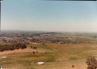
Photograph, early 1980s
... It was situated west of Sunbury and was bounded by Elizabeth Drive, Reservoir Road, Phillip Drive and Stewart's Lane....It was situated west of Sunbury and was bounded by Elizabeth Drive, Reservoir Road, Phillip Drive and Stewart's Lane. headland estate mt. holden sunbury township george evans collection A coloured landscape photograph with rounded corners of a view of Sunbury overlooking the Headland Estate before its development. ...The Headland Estate housing development began in the early 1980s. It was situated west of Sunbury and was bounded by Elizabeth Drive, Reservoir Road, Phillip Drive and Stewart's Lane.A coloured landscape photograph with rounded corners of a view of Sunbury overlooking the Headland Estate before its development. There is a rocky outcrop on the LHS of the photograph and a lightly timbered area in the middle distance. Sunbury can be seen in the distance.headland estate, mt. holden, sunbury township, george evans collection -
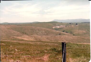 Hume City Civic Collection
Photograph, early 1980s
... The Sunbury Tip was transferred from the end of Reservoir Road as housing development spread in that area to a site on the NW side of Mt. ...Hume City Civic Collection 44 Macedon Street Sunbury melbourne The Sunbury Tip was transferred from the end of Reservoir Road as housing development spread in that area to a site on the NW side of Mt. ...The Sunbury Tip was transferred from the end of Reservoir Road as housing development spread in that area to a site on the NW side of Mt. Holden near Riddell Road in the early 1980s.A landscape coloured photograph with rounded corners. It is a panoramic view of open country NW of Sunbury near Riddell Road. There is a fence post with barbed wire hanging from it in the immediate foreground and Macedon Ranges and part of the Western Highlands can be seen across the skyline.macedon ranges, mt. macedon, camel's hump, sunbury municipal tip, george evans collection -
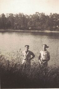 Linton and District Historical Society Inc
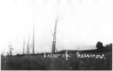
Photograph, Ivan and Lyle Grigg
... Believed to be Linton Reservoir, Mortchup Road, Linton....Believed to be Linton Reservoir, Mortchup Road, Linton. Ivan and Lyle Grigg Photograph ...Small black and white image of two men standing at the edge of a waterway. Believed to be Linton Reservoir, Mortchup Road, Linton.ivan grigg, lyle grigg -
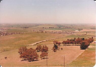 Hume City Civic Collection
Photograph, 1980s
... The photograph was taken above Reservoir Road on the lower slopes of Mt. Holden. ...Hume City Civic Collection 44 Macedon Street Sunbury melbourne The photograph was taken above Reservoir Road on the lower slopes of Mt. Holden. ...The photograph was taken above Reservoir Road on the lower slopes of Mt. Holden. It is looking south down Wilson's Lane towards some of the early Sunbury developments which grew around the Gap Road area in the early 1980s.A landscape coloured photograph with rounded corners. It is a panoramic view of Sunbury taken from the southern slopes of Mt. Holden. In the foreground there is a small cluster of trees and in the middle distance there is some evidence of housing development. Bald Hill can be seen on the skyline.wilson's lane, mt. holden, bald hill, sunbury, george evans collection -
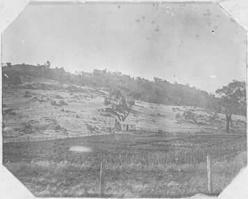 Stawell Historical Society Inc
Photograph, Man standing in paddock in front of Hut with hill behind believed to be the Sugarloaf -- Probably the McKay's property owned by McKay's
... Located at the end of Graces Hill Road and continuation of Panrock Reservoir Road Extension. ...Located at the end of Graces Hill Road and continuation of Panrock Reservoir Road Extension. Stawell Man standing in paddock in front of Hut with hill behind believed to be the Sugarloaf -- Probably the McKay's property owned by McKay's Photograph ...Man standing in paddock in front of Hut with hill behind believed to be the Sugarloaf. Probably the McKay's property owned by McKay's (2011). Originally part of Allanvale owned by the Bowtell Family. Located at the end of Graces Hill Road and continuation of Panrock Reservoir Road Extension. stawell -
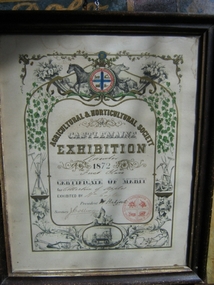 Harcourt Valley Heritage & Tourist Centre
Award Certificate, 1872
... By 1872 his orchard, in Reservoir Road, Harcourt, was fully in bearing....By 1872 his orchard, in Reservoir Road, Harcourt, was fully in bearing. ...William Eagle was a pioneer orchardist in Harcourt, who brought a dray load of apple seedlings to Harcourt from Watmough’s orchard, Greensborough in 1857 to launch the industry for which Harcourt has become famous. By 1872 his orchard, in Reservoir Road, Harcourt, was fully in bearing.A reminder that Harcourt orchards came into prominence within 15 years of establishment and Harcourt Apples have taken a pre-eminent position in the State’s horticulture industry ever since. Certificate describing the winner of the Collection of Apples category. Beautiful Certificate displays Castlemaine Agricultural and Horticultural emblem as well as various pictures of aspects of agricultural and horticultural pursuits.Agricultural and Horticultural Society of Castlemaine Exhibition November 1872, Certificate of Merit for Collection of Apples, Exhibited by Wm Eagle,President W Halford, Secretary J Collings -
 Linton and District Historical Society Inc
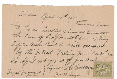
Receipt, Receipt for House Rent, 1913
... The Reverend Joseph Best, who was church of England Vicar at Linton between 1912 and 1922, "resided for the first twelve months in a rented house next to the Police Station on the Reservoir Road". In 1912/13 the Church purchased a house to serve as a Vicarage, which was dedicated on 10th April 1913....Linton and District Historical Society Inc 69 Sussex Street Linton 3360 goldfields The Reverend Joseph Best, who was church of England Vicar at Linton between 1912 and 1922, "resided for the first twelve months in a rented house next to the Police Station on the Reservoir Road". In 1912/13 the Church purchased a house to serve as a Vicarage, which was dedicated on 10th April 1913. ...The Reverend Joseph Best, who was church of England Vicar at Linton between 1912 and 1922, "resided for the first twelve months in a rented house next to the Police Station on the Reservoir Road". In 1912/13 the Church purchased a house to serve as a Vicarage, which was dedicated on 10th April 1913.Handwritten receipt dated 14.4.1913, from C.E. Godden on behalf of W. Angus, to W. Todd, Secretary of Central Committee [of Parish of Linton] for fifteen weeks rent, for house occupied by Rev. J. Best. Victorian Stamp Duty stamp affixed to page, initials "C.E.G." and date "14/4/13" written across it.rev. j. best, w. todd, c. e. godden, receipts -
Eltham District Historical Society Inc
Document - Folder, Smith, Sydney and Rebecca
... Road...Frank Kurnell...Elizabeth Smith nee Johnson...William Johnson...Sarah Johnson...St John's Church Diamond Creek...Arthur J Pickering...Charlotte Harrison...Sarah Janes Laura Smith...William Sydney Smith...Rebecca Edith Maud Smith...Thomas James Leslie Smith...Elizabeth Mary Mabel Smith...Florence Ellen Isobel Smith...Albert Percival Smith...Evelyn Hazel Walher Smith...Elsie May Smith...Jack's Creek Waterworks...Toorourrong Reservoir...Sydney Smith William Smith Elizabeth Smith Henty family Rebecca Lee William Lee Elizabeth Lee John Matthews Mary Ann Lee ship Maitland William Henny Rebecca Matthews Mary Ann Matthews Scale family of Epping Emma Smith Thomas Smith Robert Smith James Smith Rebecca Smith Reuben Smith Sarah Sussannah Smith Emma Jane Smith Midhurst at Arthur's Creek Arthur's Creek Road Frank Kurnell Elizabeth Smith nee Johnson William Johnson Sarah Johnson St John's Church Diamond Creek Arthur J Pickering Charlotte Harrison Sarah Janes Laura Smith William Sydney Smith Rebecca Edith Maud Smith Thomas James Leslie Smith Elizabeth Mary Mabel Smith Florence Ellen Isobel Smith Albert Percival Smith Evelyn Hazel Walher Smith Elsie May Smith Jack's Creek Waterworks Toorourrong Reservoir Doctors Gully Road Harold Bassett Hazel Glen State School Wesleyan Sunday School Hazel Glen Middle Station Creek Glenburn Glenburn School Allan Ferguson Diamond Creek State School Haley's Gully Road Arthur's Creek Newspaper clippings, A4 photocopies, etc Smith, Sydney and Rebecca Document Folder ...Sydney Smith (1821-1886) came to Australia as a young man. After marrying and some years in Epping, he moved to the Diamond Creek area. Contents Photocopy typed notes, undated, on Sydney Smith, family and descendants. Newspaper clippings, A4 photocopies, etcsydney smith, william smith, elizabeth smith, henty family, rebecca lee, william lee, elizabeth lee, john matthews, mary ann lee, ship maitland, william henny, rebecca matthews, mary ann matthews, scale family of epping, emma smith, thomas smith, robert smith, james smith, rebecca smith, reuben smith, sarah sussannah smith, emma jane smith, midhurst at arthur's creek, arthur's creek road, frank kurnell, elizabeth smith nee johnson, william johnson, sarah johnson, st john's church diamond creek, arthur j pickering, charlotte harrison, sarah janes laura smith, william sydney smith, rebecca edith maud smith, thomas james leslie smith, elizabeth mary mabel smith, florence ellen isobel smith, albert percival smith, evelyn hazel walher smith, elsie may smith, jack's creek waterworks, toorourrong reservoir, doctors gully road, harold bassett, hazel glen state school, wesleyan sunday school hazel glen, middle station creek glenburn, glenburn school, allan ferguson, diamond creek state school, haley's gully road arthur's creek -
Glen Eira Historical Society
Document - LECHTE, WILLIAM LUDWIG SAMUEL SEBASTION
... Road... Reservoir...Peck Family Robert Farmer Dairies Ross Murray Rosstown Hansen Hans Arnott family Peppin Family Ormond Station Malane Family Fraser Simon Overtons Shepherds Spring Road Mohlers Brighton Cemetery Mall Kim Market Gardeners Long John Farmer Fiedler Mr. Booran Road Reservoir Summers Mr. Maddocks Mr. Holland Mr. ...3 items about this person: 1/Two twelve page carbon copied documents, purportedly written by William Letchte, son of George, written in c1935/36. He writes of his jobs as a dairyman, cow minder at the age of ten tears. He recollects streets, people, residences, business and general landscape in the area, as he takes you on a tour of the area. 2/Photocopied photo of Katrina Lechte (nee Bolch?) donated by Ian Lechte, 15 Adrian Street, East Bentleigh. 3/Photocopied copy of first pages and cover of William Lechte’s booklet on ‘Caulfield 1869 – 1935 Memories of the Past’, published by the City of Caulfield, 1992. The Society has the full booklet in its book collection (not yet catalogued as of 07/07/2015).grange road, glenhuntly, glen huntly station, alma road, dairies, caulfield park, swamp, queens avenue, station street, cross street, racecourse, heywood j. g., turf club hotel, dandenong road, royal hotel, koornang road, north road, murrumbeena road, mclaurin archibald, crosbie j. w., poath road, newton mr., hooker mr., peck family robert farmer, dairies, ross murray, rosstown, hansen hans, arnott family, peppin family, ormond station, malane family, fraser simon, overtons, shepherds, spring road, mohlers, brighton cemetery, mall kim, market gardeners, long john farmer, fiedler mr., booran road, reservoir, summers mr., maddocks mr., holland mr., caulfield council, glen eira road, harriman benjamin c., kambrook road, bambra road, princess park, marriott john, hawthorn road, brickworks, hyam mr., cottages, jasmine street, sycamore street, paddy o’briens swamp, arnold tom, london tavern hotel, guess john-grocer, topp mr., poath road, pine trees, colonel le marehand, balaclava junction, chemist shop, bell mr., nicholls mr. william h., wine shop, orme mr., pepperorn mr. john, balaclava road, orchards, harvey mr. robert tailor, schubert mr., blew charlie – gardener, philpott mr. richard b., farquhar mr. william farmer, newing t. r., glen eira road, payne john, brockhoft mr., dickson mr. james, snipe t., bevan mr., mckean family john, murray family, francis mr., hart mr., mcdougall james, brady peter, cad, elsternwick station, webb mr., masters mr. samuel, master street, ford mr., anderson mr. joseph gardener, slaney mr., boxhill mr. richard, post office, newsagent, hotham street, service james, bunn mr., sargood mr., orrong road, arnold tom – dairy, officer mr., grimwade mr., alexandra street, oakleigh hall, degraves mr., wilson samuel, ‘manifold’, house names, miller septimus, alma road, knox mr. james gardener, smith mr., coachman, ‘cumloden’, lange mr., holyrood justice mr., cronin mrs. mary, mcgivenys dairy, ‘belle vista’, lloyd c. d., caulfield council, hughes mr., armstrong j. a., tom healey’s market garden, kooyong road, inkerman road, tom roe’s market garden, mcleod captain, daish captain, plumridger mr. frederick, gardeners, tester mr. thomas, kent mr., kent g., fiddes mr., billings mr., semple mr., fosberry mr., howitt or., merrett mr., orchards, hawthorn road, hines mr., ‘rosecraddock’, langdon h. j., ‘crotonhurst’, webb justice mr., renwick s., ‘garrell’, barry mr., drinsdale family, st. mary’s church, sunday school, newing miss, teachers, stephen justice mr., stephen wilberforce, mount l., grimwade’s, ‘grimwade house’, danby’s, spence mr., venables family, mr. moss’ congregational church, barnhill mrs., porter miss, webb’s, ferguson, orange, police stations, kooyong road, pennington mr., health inspectors, engineers, inkley mr., farriers, mckeon mr., ‘sylverly’, dixon mr. edward, turner mr., marriott robert, ‘ravenhurst’, thompson j. j., wott t., architects, perrin mr. francis, tennis courts, royal parade, sayce mr. joseph j. p., ricketson h., ‘glen eira’, mansions, hospitals, turner mr., evans family, stephens miss, registers, mcculloch lady, convalescent homes, prentice street, edward street, strickland, keany pat, brentwood charlie, fordham lewis, hopetoun gardens, higgins mr. joseph f. engineer, railway construction bill, evans mr., beavis mr., twycross family john, medina captain, cowderoy mr. benjamin, murray mr., moore mr., ‘glenfern’, st. georges road, glen huntly road, cedar street, hunt bill – ‘bandy hunt’, jessamine street, alder street, le page’s store, post offices, balaclava junction, stephens frank, solicitors, parkside street, robinson j., ilbery mr. and family, mclennan mrs., victoria street, savings bank, riddell parade, elworthy mr. richard, butchers, shaw mr. william, armstrong mr., guess’ hotel, sycamore street, bagshaw mr., clack joe, wawn alex, sisson family, north road, younger mr., kooyong road, sheridan joseph, anketell family – john, wren john – carpenter, wills mr. peter, attrills arnold, heffernan family, cox peter, ilbery john, hotham street, glen huntly road, page j. w., bakeries, forests, godfrey mr., blacksmiths, thompson j. j., olive street, cedar street, letchte w., tierney richard, alma road, st. kilda east, murray peter, letchte’ cows – grazing, holland grove, eskdale road, lechte katrina, lechte ian, lechte catherine, lechte warren, lechte stuart, lechte elaine -
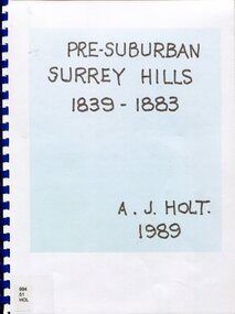 Surrey Hills Historical Society Collection
Book, Alan Judge Holt (deceased), Pre-Suburban Surrey Hills 1839-1883, 1989
... road...view hill...new street...surry mont...delany's hill...reservoir...(mr) henry jamieson (mr) ken hall (ms) edna holt (mr) frank bamford (mr) harrison buchanan scouts grange hill wattle park round hill bona vista mount albert barton street (mr) john raeburn (mr) edmund holt (mr) james dunn butter merchant mont albert road elgar road view hill new street surry mont delany's hill reservoir hill riversdale road middlesex road surrey hills (mr) aldo massora aborigines damper creek back creek west creek kooyongkoot creek (mr) john gardiner (mr) chas mullins (mr) henry elgar (mr) robert campbell (mr) alexander dyce (mr) robert brooks t budds payne (mr) hugh glass (mr) patrick trainer w virtue (mr) t fulton (mr) john crimp (mr) w dempsey (mr) w e stanbridge (mr) james atkinson j porter j collings w edde (mr) orlando fenwick (dr)(mr) l l smith (mr) j h knipe (mr) george cockcroft (sr) (mr) john martin kleinert w morton d delaney a moeller (mr) william smith (mr) e.p.s.sturt (mr) thomas blood (mr) patrick mornane (mr) henry de carle w craig j hill w oliver j keogh a laing vineyards toll gates (mr) david staig (mr) phillip kleeper (mr) goyder usher (mr) james lawler (mr) w.e. stanbridge (mr) gideon rutherford c a f mater j gadsby w h wrixon e h lamont i ainger (mr) james henty (mr) henry henty w freemantle w palmer beckett park, maranoa gardens Unpublished manuscript / notes written by Alan Holt about settlers in and around Surrey Hills bound in-house. ...Author: Alan Judge Holt amassed a significant collection of historical material related to the Surrey Hills area. Born in Moonee Ponds in 1912 to Edmund Holt and Ellen Ruby Sutton, he married Edna Jean Pallot in 1937. They lived at 62 Broughton Road, Surrey hills, had 3 sons and were strongly associated with the Surrey Hills Methodist Church. Alan was Secretary of the Victorian Lands Department and in his spare time recorded the occupancy of every property in Surrey Hills and Mont Albert at the beginning of each decade from 1890 to 1980. His collection of files and individual cards covers people, places, churches, clubs, businesses and other organisations in the area. Alan used this information to give talks and tours of the area and gifted his material to the local history collection through Jocelyn Hall.Unpublished manuscript / notes written by Alan Holt about settlers in and around Surrey Hills bound in-house. It is supported by maps showing landowners over various years from about 1840-1885(mr) henry jamieson, (mr) ken hall, (ms) edna holt, (mr) frank bamford, (mr) harrison buchanan, scouts, grange hill, wattle park, round hill, bona vista, mount albert, barton street, (mr) john raeburn, (mr) edmund holt, (mr) james dunn, butter merchant, mont albert road, elgar road, view hill, new street, surry mont, delany's hill, reservoir hill, riversdale road, middlesex road, surrey hills, (mr) aldo massora, aborigines, damper creek, back creek, west creek, kooyongkoot creek, (mr) john gardiner, (mr) chas mullins, (mr) henry elgar, (mr) robert campbell, (mr) alexander dyce, (mr) robert brooks, t budds payne, (mr) hugh glass, (mr) patrick trainer, w virtue, (mr) t fulton, (mr) john crimp, (mr) w dempsey, (mr) w e stanbridge, (mr) james atkinson, j porter, j collings, w edde, (mr) orlando fenwick, (dr)(mr) l l smith, (mr) j h knipe, (mr) george cockcroft, (sr) (mr) john martin kleinert, w morton, d delaney, a moeller, (mr) william smith, (mr) e.p.s.sturt, (mr) thomas blood, (mr) patrick mornane, (mr) henry de carle, w craig, j hill, w oliver, j keogh, a laing, vineyards, toll gates, (mr) david staig, (mr) phillip kleeper, (mr) goyder usher, (mr) james lawler, (mr) w.e. stanbridge, (mr) gideon rutherford, c a f mater, j gadsby, w h wrixon, e h lamont, i ainger, (mr) james henty, (mr) henry henty, w freemantle, w palmer, beckett park, maranoa gardens -
Tatura Irrigation & Wartime Camps Museum
Document, Alois Murr, Alois Murr Papers, 1938 to 5 October 1945
... Drawings of the single cylinder were donated by Stephen Larcombe "Pinebrow" Reservoir Road, Pettarel 3216. An interesting account of Mr Murr's longer than expected sojourn and subsequent residence in Melbourne Australia....Drawings of the single cylinder were donated by Stephen Larcombe "Pinebrow" Reservoir Road, Pettarel 3216. An interesting account of Mr Murr's longer than expected sojourn and subsequent residence in Melbourne Australia. ...Herr Alois Murr, trouble shooter, Lanz Tractors prior to war, was subsequently interned, then released, became a citizen of Australia. Drawings of the single cylinder were donated by Stephen Larcombe "Pinebrow" Reservoir Road, Pettarel 3216. An interesting account of Mr Murr's longer than expected sojourn and subsequent residence in Melbourne Australia.a red coloured hard back cover on the front cover on white self adhesive paper on which is printed in ink - Alois Murr Papers - internee, camp 1 Tatura - presented by Eric Bolwell Horsham October 1994as abovealois murr, lanz tractors, camp 1 internees -
 Surrey Hills Historical Society Collection
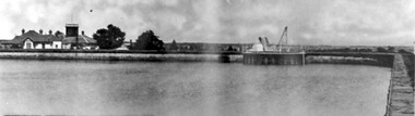
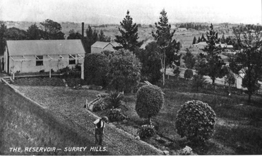
Photograph, Surrey Hills Reservoir No 1
... Kilda and running along The Esplanade. The reservoir in Canterbury Road was a large concrete structure built before the introduction of reinforcements. ...A sepia photograph within a post card of a reservoir on Canterbury Road, Surrey Hills. In the background to the left you can see the top halves of two houses and the tops of some trees. ...Kilda and running along The Esplanade. The reservoir in Canterbury Road was a large concrete structure built before the introduction of reinforcements. ...Copied by Ken Hall from an early postcard. This is Surrey Hills Reservoir No 1 on the corner of Tower Street built in c1892 at a cost of £12,000 to supply higher sections of the area. The builders were Jack and Bob Laudehr, partners in a wood yard in St. Kilda (Vic). They began by delivering firewood but extended to contract work involving timber. Another of their projects was to lay cable tram tracks commencing in Acland Street St. Kilda and running along The Esplanade. The reservoir in Canterbury Road was a large concrete structure built before the introduction of reinforcements. The excavated material was banked against the sides and pine trees were planted in it to add strength to the embankment. They were paid £2,000 for their work. Construction of Surrey Hills Number 2 Reservoir was completed in 1913 and the accompanying tower was built in 1929. It is assumed that the Miss Hill as the source of the donation (via Bill Dempsey) was Ivy Annie Hill (1902-1984). She was the only female child of William Valentine Dempsey to not marry. Bill Dempsey's mother was Laura Constance 'Birdie' Hill (1900-1968) who married Albert Dempsey.A sepia photograph within a post card of a reservoir on Canterbury Road, Surrey Hills. In the background to the left you can see the top halves of two houses and the tops of some trees. The photo takes up only the central section of the postcard.Below the photo on the front of the postcard on blue biro "Reservor [sic] Canterbury Rd / Surrey Hills." On the rear in grey lead pencil in Jocelyn Hall's handwriting: "Donor W Dempsey ------------- Keep / (nephew) / [arrow pointing down] / From Miss Hill / 10 Pembroke St SH / This house can be / seen in front of / No 12 which has / tower"1890, water supply, mmbw, edward d dyer (mr), 10 pembroke street, 12 pembroke street, surrey hills, ivy annie hill (miss), william valentine hill (mr), canterbury road, tower street, water supply structures and establishments, dams and reservoirs, jack laudehr (mr), bob laudehr (mr) -
 Linton and District Historical Society Inc
Photograph, Photographer: Alan Giles, Aerial View, Sussex Street, Linton, 1991, 1.9.1991
... Aerial view of Linton, Sussex St (Glenelg Highway) running from RH bottom corner, Mortchup Road reservoir centre RH side....Aerial view of Linton, Sussex St (Glenelg Highway) running from RH bottom corner, Mortchup Road reservoir centre RH side. Aerial View, Sussex Street, Linton, 1991 Photograph Photographer: Alan Giles ...Aerial view of Linton, Sussex St (Glenelg Highway) running from RH bottom corner, Mortchup Road reservoir centre RH side."Linton Township, Vic-1st September 1991".linton township, sussex street linton -
 Linton and District Historical Society Inc
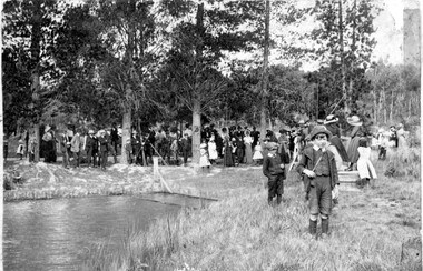
Photograph, Postcard : group of people on bushland outing, c.1911
... Black and white postcard photograph of men, women and children, thought to be a Linton State School group, on an outing in rural setting (possibly Mortchup Road reservoir)....Black and white postcard photograph of men, women and children, thought to be a Linton State School group, on an outing in rural setting (possibly Mortchup Road reservoir). Postcard : group of people on bushland outing, c.1911 Photograph ...Postcard given to Stella Todd by Linton State School head teacher Mr H. B. Williamson, wishing her a happy year in 1912.Black and white postcard photograph of men, women and children, thought to be a Linton State School group, on an outing in rural setting (possibly Mortchup Road reservoir)."To Stella Todd with best wishes for the new year 1912 from her teacher H B Williamson".stella todd, stella surman, linton state school no. 880, h. b. williamson [head teacher], picnics -
 Linton and District Historical Society Inc
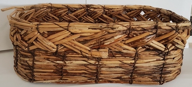
Basket, Reed Basket, Linton
... Reeds used to make it came from the old Linton Reservoir on Mortchup Road....Reeds used to make it came from the old Linton Reservoir on Mortchup Road. Reed Basket, Linton Basket ...Rectangular woven basket hand-made at Linton during the Great Depression (1930s). Reeds used to make it came from the old Linton Reservoir on Mortchup Road.baskets, handcrafts, great depression 1930s -
 Box Hill Historical Society
Photograph - Reservoirs
... This could be either the reservoir in Canterbury Road or the one in Elgar Road....This could be either the reservoir in Canterbury Road or the one in Elgar Road. ...The Reservoir in Surrey Hills. It shows someone working in the garden in the foreground and a shed on the lefthand side of the picture. This could be either the reservoir in Canterbury Road or the one in Elgar Road.B&w photosurrey hills, dams and reservoirs -
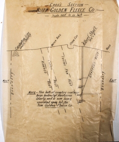 Bendigo Historical Society Inc.
Plan - North Golden Fleece Mine
... North Golden Fleece Gold Mine was located approx. 1200m west of Spring Gully Reservoir, near Diamond Hill Road. ...North Golden Fleece Gold Mine was located approx. 1200m west of Spring Gully Reservoir, near Diamond Hill Road. Margaret Roberts gold gold mine Bendigo North Golden Fleece Gold Mine Spring Gully Reservoir Plan drawn on tan tissue paper, black text. ...North Golden Fleece Gold Mine was located approx. 1200m west of Spring Gully Reservoir, near Diamond Hill Road. Plan drawn on tan tissue paper, black text. Written across top of plan: 'Cross Section, North Golden Fleece Co. 160' to an inch'. Annotations on plan: Carshalton line, water race, open cut, Albert Shaft 10'6" x 4, road. East and West marked on plan. On bottom of plan: ' This belt of country contains large bodies of auriferous quartz and is now being operated upon by the New Golden Fleece Co.' Plan forms part of the Margaret Roberts Collection of mining records. margaret roberts, gold, gold mine, bendigo, north golden fleece gold mine, spring gully reservoir