Showing 5775 items matching river%20murray%20waters%20scheme
-
 Ballarat Heritage Services
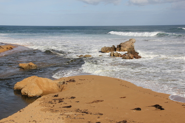
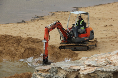
Digital photographs, L.J. Gervasoni, Hopkins River Mouth blocked - artificial channel, c2010 - 2017
Colour photograph of an rtificial chanel at the mouth of the Hopkin's River, Warrnambool. hopkins river, mouth, point ritchie, bluehole, warrnambool, coast, coastal, beach, seascape, blocked, digger, opening mouth, mechanical opening -
 Kew Historical Society Inc
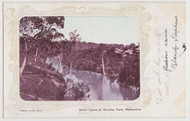
Postcard, River Yarra at Studley Park, Melbourne, 1900-04
Monochrome postcard titled lower right: “RIVER YARRA AT STUDLEY PARK, MELBOURNE”. The postcard was produced by ROBERT JOLLEY, MELB, (active 1900-1904). The photo is positioned to the left of the card and framed by an art nouveau design. A handwritten annotation on the front reads “BUT WITH THE MORNING / COOL REFLECTION CAME / BLANCHE STEPHENS”. On the reverse, there is a handwritten address in black ink to: MISS L STEPHENS / 26 WEST TERRACE / ADELAIDE. There is no division on the reverse of the postcard, dating it to before 1905. It lacks a postage stamp and postmark. Monochrome postcard of the River Yarra in Studley Park. The view is of the Yarra and its banks, with Kew on the left and Abbotsford on the right, as it appeared in the years 1900-1904. On the Abbotsford side of the river, there are a number of weeping willows lining the banks and houses on the hillside. The Studley Park side of the river includes some remnant vegetation and meandering walking tracks. Three very small figures are sitting on the Kew side. "RIVER YARRA AT STUDLEY PARK, MELBOURNE"river yarra -- kew (vic.), postcards -- kew, postcards -- studley park, robert jolley -
 Kew Historical Society Inc
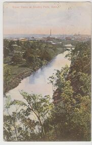
Postcard, River Yarra at Studley Park, Kew, c.1908
Colour-tinted postcard, titled in red upper left: “RIVER YARRA AT STUDLEY PARK, KEW”. On the divided reverse, the card is addressed to “MISS JOLLEY / MELB. TRAM & O[MNIBUS]. CO / BOURKE STREET, MELB”. The sender has dated the card 21.12.08. In the upper right corner, there is a pink Victorian one penny postage stamp; sent from Melbourne on 22DE 08. (The division of the reverse of the postcard, allowing a message to be written on one half and the address on the other, was not permitted in Australia until 1905.) The manufacturer of the postcard is indicated by the initials “W.T.P”, printed in a green floral diamond, printed centre top. This was the trademark of WT Pater, printers & stationers. William Thompson Pater was born in Melbourne in 1861. His business at 271 Little Collins Street offered Christmas cards, booklets, calendars, and leather goods as well as postcards and albums.Hand-tinted postcard of the River Yarra in Studley Park, Kew. The birds-eye view is of a bridge on the Yarra (Johnston Street?) linking Kew and Abbotsford as it appeared in c.1908. On the Abbotsford side of the river, fields lead down to the river, with some remnant trees. The Kew side of the river, in contrast, due to its steep banks, retains its original vegetation. In the distance is industrial development, in what might be Fairfield and Alphington.“RIVER YARRA AT STUDLEY PARK, KEW”river yarra -- kew (vic.), william thompson pater, w.t.p., postcards -- kew, postcards -- studley park, bridges - yarra river -- kew (vic.) -
 Ballarat Heritage Services
Digital photographs, L.J. Gervasoni, Hopkins River Mouth blocked - artificial channel, c2010 - 2017
Colour photograph of an artificial chanel in the blocked mouth of the Hopkins River, Warrnambool. hopkins river, mouth, point ritchie, bluehole, warrnambool, coast, coastal, beach, seascape, blocked, digger, opening mouth, mechanical opening -
 Ballarat Heritage Services
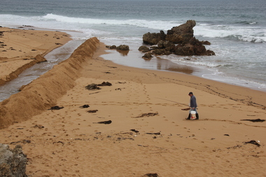
Digital photographs, L.J. Gervasoni, Hopkins River Mouth blocked - channel digger, c2010 - 2017
Colour photograph of the blocked mouth of the Hopkins River being opened by a channel digger. hopkins river, mouth, point ritchie, bluehole, warrnambool, coast, coastal, beach, seascape, blocked, digger, opening mouth, mechanical opening -
 Port Fairy Historical Society Museum and Archives
Postcard, The Rose Series / The Rose Stereographs, The Moyne River and Port Fairy, Victoria
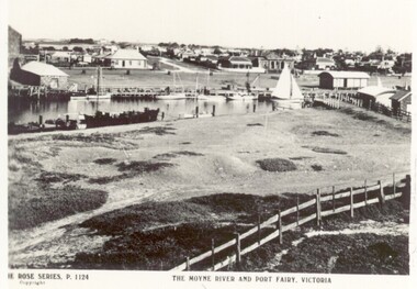
River scene of the wharf and the buildings lining the street behind. Black and white photograph taken from Battery Hill looking across Moyne river at Merrijig Inn, Customs House and Courthouse The Rose Series P.1142 copyright- The Moyne River and Port Fairy Victoriastreet, town, moyne, river, couta boat, courthouse, merrijig -
 Kew Historical Society Inc
Painting, Herbert J Woodhouse, River Yarra Near Dights Falls, c.1892
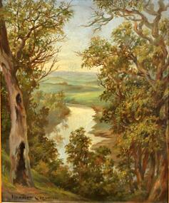
Herbert James Woodhouse (1854-1937) was born in Essex and arrived in Australia with his family in 1857. A painter-lithographer like his father and three of his brothers, he was a prizewinner in the South Australian Society of Arts exhibition of 1885. He also received commendations in exhibitions at the Victorian Academy of Arts and the New South Wales Arts Society. At an exhibition of his paintings at Scott’s Hotel in Collins Street in 1892, the reviewer for Table Talk noted that the ‘artist paints almost solely in the open air, and his studies are generally carried out during the trips of the Victorian Sketching Club’. One of the paintings singled out for praise was: ‘A very effective river scene at Willsmere, aptly named A Midstream Mirror, ... a picture powerful in its effective reflection of sunlight in the river.’ Herbert Woodhouse died in Geelong in June 1937, aged 82, and was buried in the Eastern Cemetery. A number of his sketchbooks are held in the collection of the State Library of Victoria.Framed oil painting on board of the River Yarra at Studley Park, Kew, by Herbert James Woodhouse (1858-1937). The artist has framed the narrow painting with trees in the foreground and a view of the Yarra River and rolling hills in the background. Verso, written by artist: "River Yarra Near Dights Falls"australian art - 19th century, herbert james woodhouse (1854-1937), yarra river - studley park -
 University of Melbourne, Burnley Campus Archives
Photograph - Sepia Print, 4. View of River Through Fence
Yarra River.Labelled, " View of River through fence."yarra river, mrs. jessep, alexander william jessep, principal, a.w. jessep -
 Warrnambool and District Historical Society Inc.
Platter, Transfer Hopkins River
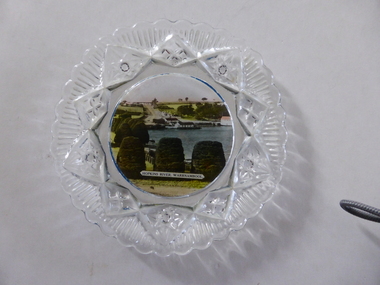
This is a souvenir dish or small plate with an illustration of the Hopkins River in Warrnambool. Included in the illustration are the rowing shed, the boathouses and the lambertiana trees in the property of Lyndoch. The souvenir dish would have been sold to tourists visiting Warrnambool or Warrnambool residents in the 1920s and 30s. This type of souvenir was popular at the time in any tourist town or place in Australia. Tourism has been an important industry in Warrnambool since the late 19th century. This item is of interest as an example of the type of souvenir produced for tourists in the 1920s and 30s. It was both a useful and decorative item. It will be useful for display. This is a small glass souvenir dish. The centre of the dish features a colour illustration of the Hopkins River, Warrnambool (near its mouth). The glass around the illustration is heavily patterned and embossed. The bottom of the dish is dark blue. ‘Hopkins River Warrnambool’ tourism in warrnambool, warrnambool history -
 Port Fairy Historical Society Museum and Archives
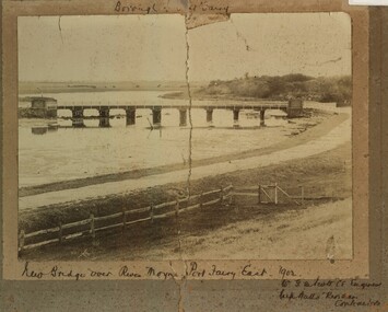
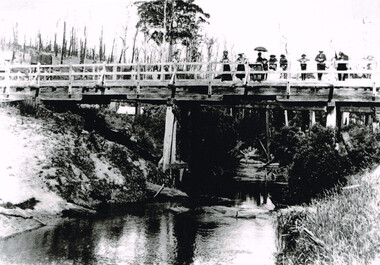
Photograph, New Bridge over River Moyne Port Fairy East 1902
New Bridge over River Moyne Port Fairy East 1902Black and white photograph view of new bridge over the river Moyne taken in 1902New Bridge over River Moyne Port Fairy East 1902 (handwritten) Mr G.W.Scott C.E.Engineer. .......Watts Riordan Contractorsbridge, river, moyne, river moyne, traffic -
 Marysville & District Historical Society
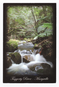
Postcard (item) - Colour postcard, Rosewood Photography, Taggerty River - Marysville, Pre 2009
A colour photograph of the Taggerty River at Marysville in Victoria.A colour photograph of the Taggerty River at Marysville in Victoria. This postcard was produced by Rosewood Photography as a souvenir of Marysville.The Cascading waters of Taggerty River The beautiful & scenic Taggerty River is a 10 minute drive from Marysville, Victoria./ Surrounded by tree ferns & mos covered rocks, the tranquil sounds of the flowing/ river are great place to visit while in Marysville. Photography & Design by/ Roswood Photography/ Mulgrave, Victoria/ [email protected]/ Tel:1300 769 922 Date Stamp 2004/ 6 PM SUNDAY/ Dear Norma & Rod/ All is beauty + peace here/ -the colours are simply/ beautiful every where./ I've done some pleasant/ walking + look forward/ to some more/ Frosty/ mornings perishing - but/ days lovely!!/ Take care - Love-/ Sar-jane A MR + MRS R McDONALD/ 24 PRINCETOWN RD/ MT WAVERLEY/ VIC 3149marysville, taggerty river, victoria, rosewood photography, postcard, souvenir -
 Otway Districts Historical Society
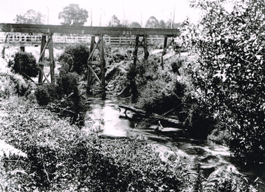
Photograph, Knox Collection, Railway Bridge over Gellibrand River, 1902
Railway bridge over the Gellibrand River, 1902. Note the people on the roadway bridge in the top left corner. B/W.colac; beech forest; gellibrand; railway; -
 Melbourne Legacy
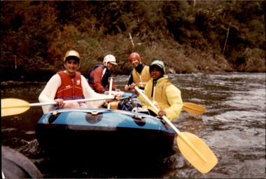
Photograph - Junior legatee outing, Rafting the Thomson River, 1993
Legacy have many programs to send young junior legatees on activities, camps and outings. The photos shows junior legatees on a white water rafting trip on the Thomson River in 1993. It was stored with other photos of Junior Legatees from the 1980s and 1990s. A record of a Legacy providing experiences for the junior legatees.Colour photo x 5 of junior legatees white water rafting in the Thomson River.Hand written on back in blue ink: 'Junior Legacy Thomson River Rafting. Nov 13/14 1993'junior legatee outing, rafting, river -
 Orbost & District Historical Society
folder, Orbost Bridges - Snowy River Road Bridges, 1974 1976
This folder was compiled in October 2015 from documents, magazines. papers and photographs donated by David Jellie, engineer in charge 1974 - 1976. In early 1974, as an Engineer with the Country Roads Board, David came to Orbost as the Supervising Engineer for the construction of the new bridges which were part of an 8.4km Orbost bypass road design. This was a major project involving not only a new bridge over the Snowy River (including Lochiel Lagoon), but other bridges over Ashby’s Gulch and Watt’s Gulch. These new bridges were opened in November 1976 with the unveiling of a plaque on the eastern end of the $2.4M Snowy River Bridge. (ref. May Leatch)This item is a useful reference tool on the construction history of the Snowy River Road bridges.A white plastic folder - Orbost Bridges - Snowy River Road Bridges. it contains newspaper articles, booklets, photographs and documents relating to the construction of the Snowy River Road Bridge in 1974 -1976.on front cover - 1974 - 76 ORBOST / SNOWY RIVER ROAD BRIDGES * construction * photos * articles * plans Donated by David Jellie Oct 2015snowy-river-bridges jellie-david -
 Otway Districts Historical Society
Photograph, Gellibrand River railway bridge, 1901
Photograph, B/W, A4. Railway bridge over the Gellibrand River with people standing at the right-hand end, a railway water tank nearby on the left, and a tent underneath on the left.gellibrand, gellibrand river;railways; bridge; -
 Australian National Surfing Museum
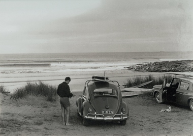
Photograph, Jack Eden, Kennett River, 1964
Black and white photograph taken by Jack Eden at Kennett River, Victoria, in 1964. Image is of a surfer standing next to a VW with surfboards on the roof. Another car and more boards on the ground also appear in the picture. In the background is a peeling wave with a surfer riding it. More surfers sit waiting. Jack Eden was a pioneer of Australian surfing and surf photography. His images capture something of arguably the halcyon days of Australian surfing. Rare image of surfing at remote Kennett Rover along the Great Ocean Road.Black and white photograph taken at Kennett River, Victoria, of a surfer standing next to a VW sedan with surfboards on the roof. Another car and more boards on the ground is to the right of the VW. In the background is a righthand, peeling wave with a surfer riding it.Titled: Australia Jack Eden, Kennett River, Victoriakennett river, surfboards, vw sedan, jack eden, great ocean road -
 Port Fairy Historical Society Museum and Archives
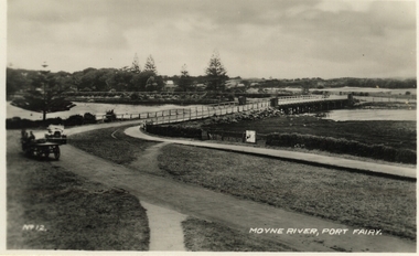
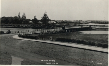
Postcard, Moyne River, Port Fairy
Postcard made for tourists visiting port FairyBlack and white photograph of the road bridge crossing the river Moyne No 12 - Moyne River, Port Fairymoyne bridge, postcard, botanical gardens, cart, car, river, road, gipps street -
 Warrnambool and District Historical Society Inc.
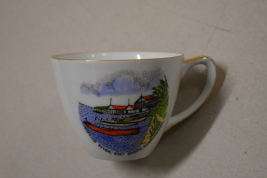
Cuo, Westminster China Australia, Hopkins River Boat, Mid 20th century
Tourism has been an important industry in Warrnambool for over 100 years. In the late 19th century Warrnambool was promoted as a spa resort offering a mild climate, seaside swimming and hot and cold seawater baths. Today tourists come in winter to see the Southern Right whales at Logans Beach and in summer they come for a beach holiday. The Hopkins River is a popular recreation destination with boating, fishing and water skiing. The Proudfoots Boathouse was established in 1885 by Thomas Proudfoot. This cup is an interesting example of a Warrnambool tourist souvenir from the mid to late 20th century.This is a small white china cup. There is gold edging around the rim and on the handle. On the side of the cup is a coloured image of Proudfoots Boatsheds at the mouth of the Hopkins River in Warrnambool. Hopkins River Boatsheds Warrnambool Fine China Westminster China Australia tourism in warrnambool, history of warrnambool -
 Kew Historical Society Inc
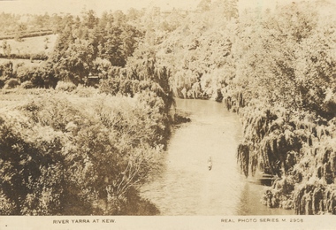
Photograph, River Yarra at Kew, c.1927
The River Yarra was a popular subject for photographic postcards. The postcards provide an interesting perspective of plantings on the banks of the Yarra at various periods. Small, sepia coloured real photo postcard of the River Yarra at Kew. The bird's eye view, presumably taken from Victoria Street Bridge shows the banks of the Yarra in the foreground densely planted with weeping willows. There is also canoe in the foreground. The expanse of lawn in the middle ground is that of 'Swinton', the tower of which can faintly be seen at the top centre of the view. "RIVER YARRA AT KEW / REAL PHOTO SERIES M. 2908 "real photo postcards, yarra river -- kew (vic.), postcards -- 1920s -
 Tatura Irrigation & Wartime Camps Museum
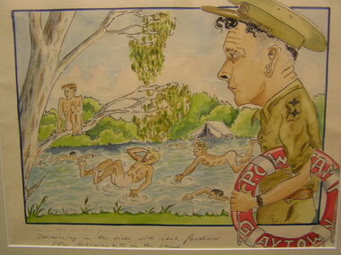
Sketch - Watercolour, Georg Rosenkranz, Swiming in the river with Lieut. Gardener, 1941/2
Artist Georg Rosenkranz, crewman aboard the HSK Kormoran, painted this while at Graytown Prisoner of War Camp.Watercolour painting of people swimming in a river, with onlooking soldierSwimming in the river with Lieut. Gardener for behaviour OK in the Camp.graytown pow camp, georg rosenkranz, illustrations, watercolour, gardener -
 Falls Creek Historical Society
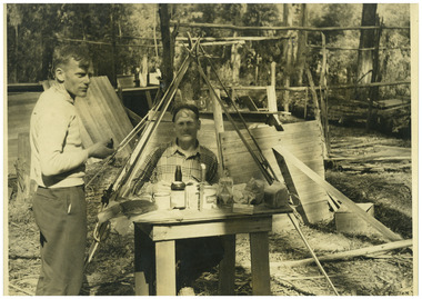
Photograph - Big River Survey Camp, c1949
MEYER COLLECTION - FALLS CREEK PHOTOS In 1947 a determined group of like-minded State Electricity Commission (SEC) staff including Ray Meyer, the chief surveyor of the Kiewa Hydro-Electric Scheme, had a common interest that revolved around the skiing potential of the snow-covered high plains which included what is now the resort of Falls Creek. The six SEC employees, Toni St Elmo, Ray Meyer, Jack Minogue, Lloyd Dunn, Adrian Ruffenacht and Dave Gibson (together with their families) banded together to secretly build a 'hut' that was the first ski lodge at Falls Creek. Using a road built in 1930s to gain access to Falls Creek, their hut project was carried out in secret as efforts by other skiers were blocked by H.H.C. Williams – the engineer in charge of the Hydro Scheme. In 1946 Ray Meyer made a trip to the Lands Office in Melbourne. He came away with a 99-year lease on three acres that was ideally suited for a hut designed by Lloyd Dunn. Adrian Ruffenacht (Design Engineer for the KHS) had suggested where the group should build because of easy access to a spring for water. Much of the building material required was scavenged from derelict huts on the high plains. Due to the need for secrecy, the determined group worked on the hut in the evenings and weekends to avoid detection. During the building period the group had met at Echidna Rock (now known as Eagle Rock) where Skippy St Elmo announced, "This is my favourite ‘Skyline’.” And so the first lodge in the area at Falls Creek Ski Resort came into existence. With the development of the International Poma in the 1970s, the Skyline Lodge, which was sited between the ski-lift’s pole one and pole two, was demolished. However, the legacy of Ray Meyer, Toni St Elmo, Jack Minogue, Lloyd Dunn, Adrian Ruffenacht and Dave Gibson and Skyline lives on in the vibrant atmosphere of Falls Creek Resort. The MEYER COLLECTION documents developments on the Kiewa Hydro Scheme and their life at Falls Creek from the mid 1930s to 1960s.This image is significant because it documents development of the Kiewa Hydroelectric Scheme.Two black and white images at the Big River Old Survey Camp.Photo 1 - Breakfast at Big River Left to RIght Ray Meyer, Wal Johnson Photo 2 - Big River Survey Camp at foot of T Spur C 1949, Kiewa RIver Survey Team.kiewa hydroelectric scheme, ray meyer, wal johnson -
 Port Fairy Historical Society Museum and Archives
Postcard, Moyne River, Port Fairy
Circa 1902Black and white photograph of the Moyne river road bridge with no traffic taken for use as a PostcardMoyne River, Port Fairy - No23moyne bridge, circa 1900's, moyne river, bridge, road -
 Kew Historical Society Inc
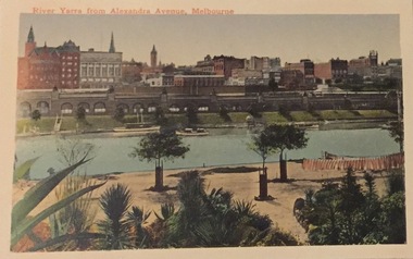
Postcard, River Yarra from Alexandra Avenue, Melbourne, c.1911
Collection of thirty-nine postcards donated by Jillian Rigby which had been owned by her grandparents, George and Edith Weir, who from c.1917 lived at 84 Princess Street, Kew. The mostly 'mint' postcards were purchased in Victoria and while travelling overseas. The sole dated postcard is dated from 1929. The postcards are numbered sequentially from 2017.0058.01-39. The remainder of the collection donated by Jill Rigby which was once owned by the Weirs of Broken Hill and Kew consist of costumes, costume accessories, photographs, and documents.The postcards in the Weir collection, especially those purchased on a trip or trips to the mother country, i.e. United Kingdom, represent a representative sample of sites that were considered significant to those Australians undertaking a reverse grand tour by member of the erstwhile colonies. Those postcards which are early views of Melbourne must have been produced commercially for some decades from the early part of the 20th century.River Yarra from Alexandra Avenue, Melbourne. Coloured postcard. Weir collection."River Yarra from Alexandra Avenue, Melbourne"postcards, george and edith weir, alexandra avenue - melbourne, yarra river, weir collection -
 Port Fairy Historical Society Museum and Archives
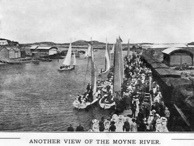
Photograph - Souvenir folder, Another View of the Moyne River
This photograph probably taken during Terang day. The people of Terang used to come to Port Fairy by train for the day and lots of events were put on for the people to take part in. Boating, swimming, picnicing in the botanical gardens, foot races, cricket etc.black and white photograph of the Moyne river showing a crowd of tourists possibly on Terang day as they alighted from the train that has pulled onto the wharfAnother view of the Moyne riversouvenir, port-fairy, terang day, train, wharf, moyne river, boats, crowd, people -
 Port Fairy Historical Society Museum and Archives
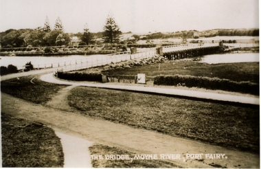
Postcard, Valentine Publishing Co, The Bridge Moyne River Pt Fairy, 10.04.1929
Black and white Photograph of the bridge crossing the Moyne river with Gipps street in the foreground cleared land in the background taken for use as a postcardThe Bridge Moyne River Pt Fairymoyne bridge circa 1930, bridge, moyne river, river, road -
![Scene on the River Campaspe / [by] Nicholas Caire, circa 1876](https://victoriancollections.net.au/media/collectors/550653872162f11fb04854aa/items/577b50b0d0cdd10948cb4cf6/item-media/577b51d2d0cdd10948cbedda/item-fit-380x285.jpg) Kew Historical Society Inc
Kew Historical Society IncPhotograph, Anglo-Australasian Photographic Company, Scene on the River Campaspe, c. 1876
Nicholas Caire was born on Guernsey in the Channel Islands in 1837. He arrived in Adelaide with his parents in about 1860. In 1867, following photographic journeys in Gippsland, he opened a studio in Adelaide. From 1870 to 1876 he lived and worked in Talbot in Central Victoria. In 1876 he purchased T. F. Chuck's studios in the Royal Arcade Melbourne. In 1885, following the introduction of dry plate photography, he began a series of landscape series, which were commercially successful. As a photographer, he travelled extensively through Victoria, photographing places few of his contemporaries had previously seen. He died in 1918. Reference: Jack Cato, 'Caire, Nicholas John (1837–1918)', Australian Dictionary of Biography.An original, rare photograph from the series 'Views of Victoria: General Series' by the photographer, Nicholas Caire (1837-1918). The series of 60 photographs that comprise the series was issued c. 1876 and reinforced a neo-Romantic view of the Australian landscape to which a growing nationalist movement would respond. Nicholas Caire was active as a photographer in Australia from 1858 until his death in 1918. His vision of the Australian bush and pioneer life had a counterpart in the works of Henry Lawson and other nationalist poets, authors and painters.Views of Victoria (General Series) No.25 / ‘Scene on the River Campaspe’ / Albumen silver photograph mounted on boardOn Reverse: ‘The River Campaspe flows into the River Murray, near the Town of Echuca. It is a river of considerable size, and is subject to frequent overflowing of its banks, in consequence of the low flat country through which it runs. Our illustration represents the River during one of the periodical floods, its depth being over thirty feet at the time.’nicholas caire (1837-1918), australia - landscape photography -
 Federation University Historical Collection
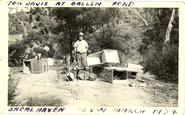
Photograph - Photograph - black and white, Oallen Ford and Shoalhaven River, 1934
Two black and white photographs associated with Donald Mather. .1) A man, Tom Davis stands surrounded with gold mining equipment such as gold pans, cradles, picks and buckets. He is at Oallen Ford on the Shoalhaven River, New South Wales .2) A man stands beside a ute with 2 women standing on the tray. The photo was taken after crossing a ford at Shoalhaven, New South Walesdonald mather, mather, shoalhaven river, mining, ute, utility, car, gold mining -
 Warrnambool and District Historical Society Inc.
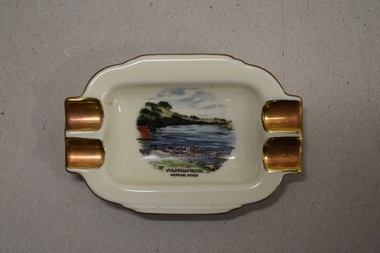
Ashtray, Alka Kunst, Warrnambool Hopkins River, c. 1960
This item was bought as a souvenir of Warrnambool in the mid 20th century when cigarette smoking was more widespread and was socially acceptable. Tourism in Warrnambool has been an important industry for over 100 years. In the late 19th century Warrnambool was promoted as a spa resort with its mild climate, sea bathing and its hot and cold sea water baths complex. Today visitors come in winter for the May Racing Carnival and to see the Southern Right whales at Logans Beach and in summer they come for a beach holiday. The image on the dish shows the Warrnambool Hopkins River near its mouth. The boatshed is no longer there with sections of the building being relocated to a site in Henna Street and used for indoor recreational purposes.This ash tray is retained as an example of a local tourist souvenir sold to tourists in the 1960s. This is a small white china dish made in an oval shape and slightly raised from the surface on which it sits. The ends of the dish have four gold coloured indents for stubbing cigarettes. There is a gold rim around the edge of the dish and a coloured image of the old boat shed and jetty on the Hopkins River in Warrnambool. On the base of the dish is the logo of the maker and printed details.Warrnambool Hopkins River Alka Kunst Bavaria tourism in warrnambool, history of warrnambool -
The 5th/6th Battalion Royal Victoria Regiment Historical Collection
Print - Book, Miracle on the River Kwai
River KwaiWhite cover - black & green writingMiracle on the River Kwai5/6 rvr, officer's / sergeant's mess -
 Kew Historical Society Inc
Photograph, Marnie McLeod, Floods on the River Yarra at Kew, 1916
The donation was accompanied by the following letter from the donor: "Hi. I found these in with family photos. Taken by family as Mamie McLeod was living in Fellows Street, Kew, so would be near there. Retain (or discard) as you see fit." [Donor's name and address withheld from public view]. To gain an insight into the flood levels at Kew, it is worth reading newspaper accounts of the event. The Age published an article - Valuable Gardens Destroyed at Kew - on 25 September 1916: "VALUABLE GARDENS DESTROYED AT KEW. From the heights of Studley Park, Kew, a splendid view of the flood waters can be obtained, and yesterday afternoon, despite continuous rain, crowds of citizens assembled there to witness the spectacle. There is a vast stretch of water some 300 or 400 yards broad, above the foot bridge connecting Gipps-street, Collingwood, and Studley Park. The river is only about 3 feet from the top of the embankment connecting with the ramp of the bridge on the Studiey Park side. When the upper llood waters come down it is almost a certainty that tne embankment will be submerged and the bridge rendered impassible. Below the bridge the waters again stretch out, and have submerged all the low-lying land on the Collingwood side and invaded the back premises ot the Kodak Co., Phoenix Biscuit Factory, a tannery adjoining thereto, the Shamrock Brewery, and Chinese gardens in the vicinity. At Walmer-street-bridge, at the end of Studley Park, the low-lying land on the Kew side is covered with water to the depth of many feet. Tlie land in question is owned in a great part by Mr Frank Lavers who haa gone in for intense culture on a pretty liberal scale on both the slopes of the hill and on the river flat. On the latter he is cultivating many acres of asparagus, and has at a considerable cost spent three years in preparing the ground and installing an irrigation system, reticulated from the Yan Yean water supply. This year the asparagus was put down, and the plants were in a promising condition. Tlie flood waters are now flowing fast over the land. The crop is ruined, and three years' work and expenditure destroyed. Mr. Laver's private residence fortunately is high above flood level, but two houses he owns off Young-street have been flooded out. Having been warned in time, the tenants removed their furniture hefore the water came down to Mr. Laver's residence, where they themselves have been given accommodation in the meantime. All the river flats in East Kew are under water. One or two low-lying houses have been flooded. Chipperfield's boat shed at Willsmere is nearly covered, and some Chinese gardens in the vicinity are several feet under water."This, and the other three photographs donated of floods in Kew are believed to be the earliest in the collection. Together with our original MMBW River Yarra map showing flood levels, these items, when compared allow researchers to gain a visual perspective of the extent of the flood in 1916. Panoramic view, believed to be looking north towards Fairfield from the Zig-Zag Bridge on the River Yarra. The inscription on the reverese identifies it as taken before 1920.Inscription on reverse in ink "(pre 1920) Flood from Zig-zag bridge Yarra River, Kew Vic."river yarra, kew, floods 1916, zig-zag bridge