Showing 16 items matching "river avon"
-
 Bendigo Historical Society Inc.
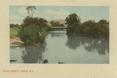
Postcard - POSTCARD WITH PHOTO OF AVON RIVER, YORK W. A, 1912
... POSTCARD WITH PHOTO OF AVON RIVER, YORK W. A....Postcard with photo of Avon River, York, W. A....History House 11 Mackenzie Street Bendigo goldfields Postcard with photo of Avon River, York, W. A. Postcard POSTCARD WITH PHOTO OF AVON RIVER, YORK W. ...Postcard with photo of Avon River, York, W. A. -
 Ballarat Heritage Services
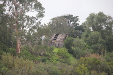
Photograph - Photograph - Colour, Lisa Gervasoni, Remains of Angus McMillan's Bushy Park Home, 2014, 07/06/2014
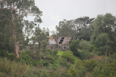
... ...avon river...Angus Macmillan named the Avon River after the river of the same name in his native Scotland. ...Photographs of the remains of a timber home used by squatter Angus McMillan at his "Bushy Park" property on the Avon River. ...Angus Macmillan named the Avon River after the river of the same name in his native Scotland. ...Angus McMillan was born in 1810 at Glenbrittle in the Isle of Skye. He was one of fourteens sons of Ewan McMillan. Angus McMillan arried i New South Wales in January 1839, and became an overseer for Captai nLachlan Macalister. I n 1839 Angus McMillan travelled south. He settled for a time on Jame MacFarlane's statin at Currawong. IOn 28 May 1839 Angus MacMillan stated travelling southward toward the coast. Angus Macmillan named the Avon River after the river of the same name in his native Scotland. In 1840 he established a pastoral run at Bushy Park, near Maffra. William Odell Raymond established a run in the area in 1842, and built his house, Strathfieldsaye, during 1848–54. European settlement did not take place without resistance, and in return, massacres were inflicted by Angus McMillan and others on Gunai people, especially between the years of 1840 and 1850. (wikipedia) The first application for the 'Bushy Park' run appears in the “Port Phillip Gazette” on 13 August 1843. It was taken up by Angus McMillan, who also took up the 'Boisdale' run for his employer Lachlan Macalister at the same time. In March 1844 a Licence to occupy the 16,000 acre 'Bushy Park' was granted to McMillan. In the late 1840s Andrew Martin and Matt McCraw built Angus McMillan's Bushy Park homestead. Aboriginal killings in Gippsland area most often were never formally recorded, but lived on in folklore, mainly in place names pinpointing what some historians now refer to as "massacres", and others as "conflicts". There is Boney Point, on Lake Wellington, Butchers Creek, near Metung, Slaughterhouse Gully, at Buchan, Skull Creek, at Lindenow, and, notoriously, Warrigal Creek, at Woodside. "Here, according to a couple of contemporary - though not eyewitness - reports, between 50 and 150 blacks were killed in an orgy of revenge after the murder and mutilation of a leading Scots settler, Ronald Macalister. If anybody had any doubts about the fitness of commemorating McMillan's name, no one voiced them then. Gippsland was, and still is, dotted with stone cairns tracing his route from Omeo, down the Tambo Valley to the fertile plains where he was to make (and lose) his fortune. And where, according to a growing body of opinion, he was to lead the "Highland Brigade", a band of armed settlers, against the Kurnai. History is fiction agreed on, and it is written by the winners. For most of the past 150 years, McMillan has been hailed as a trail-blazing pioneer. The legend began to crumble 20 years ago with publication of new histories, which at first outraged Gippsland historical societies and old residents, but which have gradually changed the way McMillan is viewed. ... Still, not all McMillan's contemporaries agreed with the "Highland Brigade" and its methods. Henry Meyrick, an English-born squatter, wrote to relatives in disgust about his neighbours. He estimated that 450 had been killed, and wrote: "Men, women and children are shot down whenever they can be met with. Some excuse might be found for shooting the men by those who are daily getting their cattle speared, but what they can urge in their excuse who shoot the women and children I cannot conceive." (http://www.theage.com.au/articles/2002/04/26/1019441303552.html, accessed 20 September 2016.) The Gippsland electorate is called 'McMillan' in his honour. Photographs of the remains of a timber home used by squatter Angus McMillan at his "Bushy Park" property on the Avon River. angus mcmillan, bushy park, avon river, squater -
 Victorian Interpretive Projects Inc.
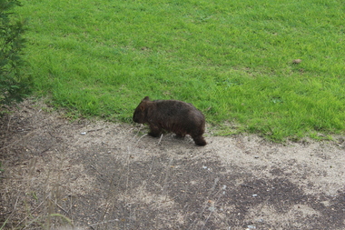
Photograph - Colour, Wombat near Maffra, Victoria, 1204, 2014
... ...Avon River...A wombat walks along the roadway on the way to the Avon River, near Maffra. Once the wombat reached the river it had a good drink from the river bank....PO Box 93R, Redan, 3350 goldfields Wombats are indigenous to Australia. Wombat Avon River Maffra A wombat walks along the roadway on the way to the Avon River, near Maffra. ...Wombats are indigenous to Australia.A wombat walks along the roadway on the way to the Avon River, near Maffra. Once the wombat reached the river it had a good drink from the river bank.wombat, avon river, maffra -
 Lakes Entrance Historical Society
Map - Yeerung County of Tanjil
... Shows Parish plan, landowners, Princes Highway, Eastern rail, Princes Highway from Stratford to Meerlieu, River Avon....Lakes Entrance Historical Society 4 Marine Parade Lakes Entrance gippsland Roads and Streets Railway Waterways Shows Parish plan, landowners, Princes Highway, Eastern rail, Princes Highway from Stratford to Meerlieu, River Avon. Map Yeerung County of Tanjil ...Shows Parish plan, landowners, Princes Highway, Eastern rail, Princes Highway from Stratford to Meerlieu, River Avon.roads and streets, railway, waterways -
 Magnet Galleries Melbourne Inc
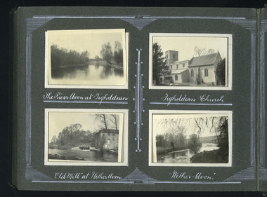
english scenery
... ...river avon...Magnet Galleries Melbourne Inc 2/640 Bourke Street 3000 Melbourne melbourne england Figheldean river avon ww1 world war 1 english scenery ...england, figheldean, river avon, ww1, world war 1 -
Stawell Historical Society Inc
Map, Department of Crown Lands and Survey Victoria, Allotments in the Township of Banyana. Parish of Burrum Burrum. 1946 / 1971, 1971
... Richardson River. Avon River Junction...Stawell Historical Society Inc 46 Longfield St Stawell grampians Richardson River. Avon River Junction Survey Reprint of the 1946 edition. ...Richardson River. Avon River JunctionPaper Map of County of BorungReprint of the 1946 edition. Drawn and reproduced at the Department of Crown Lands and Survey Victoria 1971.survey -
 Old Gippstown
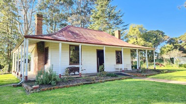
Building - Bushy Park
... ...Avon River...It was taken up by Angus McMillan, who took up the Boisdale run across the Avon River at the same time, for his employer Lachlan Macalister. ...It was taken up by Angus McMillan, who took up the Boisdale run across the Avon River at the same time, for his employer Lachlan Macalister. ...13 August 1843 First application for the Bushy Park run appeared in the “Port Phillip Gazette”. It was taken up by Angus McMillan, who took up the Boisdale run across the Avon River at the same time, for his employer Lachlan Macalister. This house was built in 1848. March 1844 Licence to Bushy Park granted to McMillan. It consisted of 16,000 acres. Late 1840s Bushy Park homestead built for McMillan by Andrew Martin and Matt McCraw. High local historic significance as associated with major pioneer and a very old white settlement in Gippsland.A square shaped timber house, with a corrugated iron roof over shingles. It has a verandah that covers both the front and sides of the house. The house is contructed of redgum timber, and internally has four rooms.National Trust of Australia Plaque - Bushy Park Homestead - Class 'C'mcmillan, angus, old gippstown, west gippsland, gippsland, gippsland heritage park, goldfields, victorian era, moe, historical village, wellington shire, avon river, boisedale, briagolong, dargo, murdoch mackintosh, national trust, andrew martin and matt mccraw., latrobe valley, old gippstown heritage park, gunaikurnai, latrobe city council -
 Victorian Interpretive Projects Inc.
Photograph - colour, Lisa Gervasoni, Ruins of Angus McMillan's original Bushy Park Homestead near Maffra, 2014, 07/06/2014
... ...avon river...Angus McMillan named the Avon River after the river of the same name in his native Scotland. ...PO Box 93R, Redan, 3350 goldfields Angus McMillan named the Avon River after the river of the same name in his native Scotland. ...Angus McMillan named the Avon River after the river of the same name in his native Scotland. In 1840 he established a pastoral run at Bushy Park, north-west of the township. William Odell Raymond established a run in the area in 1842, and built his house, Strathfieldsaye, during 1848–54. European settlement did not take place without resistance, and in return, massacres were inflicted by Angus McMillan and others on Gunai people, especially between the years of 1840 and 1850. (wikipedia)bushy park, angus mcmillan, avon river -
Federation University Historical Collection
Reports, Big Cats Sightings and Stock Kills 2000-2011, 2000-2011
... ...avon river...The folder was collected for research being conducted by David Waldron. australian mythical animals collection david waldron Department of Primary Industries rangers peter walsh Warragul creek Binginwarri Coongulla Straford Licola Blanket Hill Darramin Blanket Hill Woodside BEach heyfield puma panther cowwarr glenmaggie bolands bluff darrimen bolands bluff binginnwarri dawson the springs mt taylor black range driffield west Snowy plains airstrip glenmaggie north jack smith lake munro briagaling dutson downs connors plain giffard west darriment Joyces Road Junction Giffard West wallaby creek south Gippsland Highway avon river orbost four mile creek Folder of reports of Big Cat by rangers. ...The folder or correspondence is the result of a Freedom of Informaition request made to the Department of Primary Industries in 2011. The folder was collected for research being conducted by David Waldron.Folder of reports of Big Cat by rangers. australian mythical animals collection, david waldron, department of primary industries, rangers, peter walsh, warragul creek, binginwarri, coongulla, straford, licola, blanket hill, darramin, blanket hill, woodside beach, heyfield, puma, panther, cowwarr, glenmaggie, bolands bluff, darrimen, bolands bluff, binginnwarri, dawson, the springs, mt taylor, black range, driffield west, snowy plains airstrip, glenmaggie north, jack smith lake, munro, briagaling, dutson downs, connors plain, giffard west, darriment, joyces road junction, giffard west, wallaby creek, south gippsland highway, avon river, orbost, four mile creek -
 Federation University Historical Collection
Postcard - black and white, Great Pulteney Street, Bath
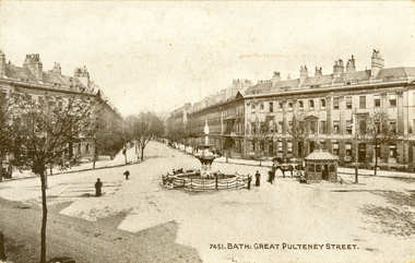
... Great Pulteney Street is a grand thoroughfare that connects Bathwick on the east of the River Avon with the City of Bath, England via the Robert Adam designed Pulteney Bridge. ...Barker Library (top floor) Mount Helen goldfields Great Pulteney Street is a grand thoroughfare that connects Bathwick on the east of the River Avon with the City of Bath, England via the Robert Adam designed Pulteney Bridge. ...Great Pulteney Street is a grand thoroughfare that connects Bathwick on the east of the River Avon with the City of Bath, England via the Robert Adam designed Pulteney Bridge. Famous former residents of the street have included the novelist Jane Austen and the anti-slavery campaigner William Wilberforce.A black and white postcard showing Great Pulteney Street in Bath. The street is lined with triple storey building. A fountain and small shelter is located in the foreground.This card was purchased by an Australian soldier, probably Henry Smerdon Holmes, during World War One. chatham-holmes family collection, bath, gret pulteney street, fountain -
 Lakes Entrance Historical Society
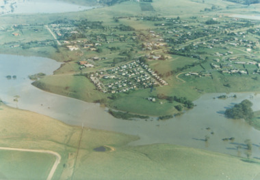
Photograph - Mitchell River in flood Bairnsdale Victoria 1990
... There was a deluge overnight in headwaters of Mitchell and Avon Rivers so the rivers rose overnight and flooded low lying areas...Lakes Entrance Historical Society 4 Marine Parade Lakes Entrance gippsland There was a deluge overnight in headwaters of Mitchell and Avon Rivers so the rivers rose overnight and flooded low lying areas Rivers Floods Colour aerial photograph of Mitchell River in flood showing Clifton Waters Village in centre and township of Wy Yung near Bairnsdale Victoria Photograph Mitchell River in flood Bairnsdale Victoria 1990 ...There was a deluge overnight in headwaters of Mitchell and Avon Rivers so the rivers rose overnight and flooded low lying areasColour aerial photograph of Mitchell River in flood showing Clifton Waters Village in centre and township of Wy Yung near Bairnsdale Victoriarivers, floods -
 Bendigo Military Museum
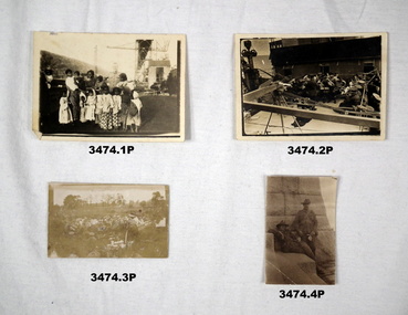
Photograph - PHOTOGRAPHS WW1, c.1915
... Four x black & white photos presumable taken by Bert HEWSTON during his war experience. .1) Group of Kaffir women & children. .2) Band playing onboard the ship Wandilla, conveying Bert to Europe. .3) Band playing on Avon River, Durrington. .4) 2 x uniformed soldiers. ...Part of the HEWSTON collection re WW1 & WW2. photography-photographs military history - army Four x black & white photos presumable taken by Bert HEWSTON during his war experience. .1) Group of Kaffir women & children. .2) Band playing onboard the ship Wandilla, conveying Bert to Europe. .3) Band playing on Avon River, Durrington. .4) 2 x uniformed soldiers. ...Bert HEWSTON, refer Cat No 2759.2 for his service history. Part of the HEWSTON collection re WW1 & WW2.Four x black & white photos presumable taken by Bert HEWSTON during his war experience. .1) Group of Kaffir women & children. .2) Band playing onboard the ship Wandilla, conveying Bert to Europe. .3) Band playing on Avon River, Durrington. .4) 2 x uniformed soldiers. All different sizes.photography-photographs, military history - army -
 Victorian Interpretive Projects Inc.
Photograph - Colour, Alexander McMillan's Bushy Park near Maffra, 2014
... He called his run "Bushy Park" which was located on the banks of the Avon River. Gippsland Maffra Bushy Park Alexander McKinnon Colour photograph of the entrance to Bushy Park near Maffra. ...Alexander McMillan was a squatter and pioneer of Gippsland, Victoria. He called his run "Bushy Park" which was located on the banks of the Avon River.Colour photograph of the entrance to Bushy Park near Maffra.gippsland, maffra, bushy park, alexander mckinnon -
 Orbost & District Historical Society
black and white photographs, 1890s
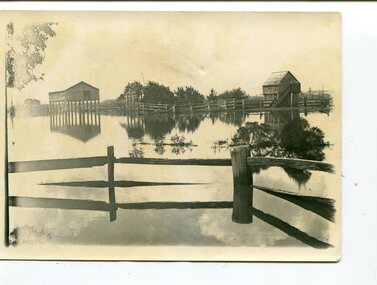
... Avon from a Mr Street. The home was situated at the bottom of the paddock, near the corner of Morley and Livingstone streets. The farm stretched from Tennyson Street to the end of Snaggers Lane and along the river frontage to “Carinya” Cameron Home. ...Avon from a Mr Street. The home was situated at the bottom of the paddock, near the corner of Morley and Livingstone streets. The farm stretched from Tennyson Street to the end of Snaggers Lane and along the river frontage to “Carinya” Cameron Home. ...Peter Cameron, came to Orbost in 1885, at the age of 69, having sold his farm at Geelong. Peter bought the property ―Glen Avon from a Mr Street. The home was situated at the bottom of the paddock, near the corner of Morley and Livingstone streets. The farm stretched from Tennyson Street to the end of Snaggers Lane and along the river frontage to “Carinya” Cameron Home. In the Gippsland Times on Wednesday. 2 Jul 1890 on Page 3 is an article titled "THE SNOWY RIVER CALAMITY" which describes an ".unexpectedly sudden rush of water down the flats..... the terrified people commenced to remove their stock from the land and the work of saving property was continued all day ............ many head of cattle were washed away.......The river road, for its entire length, is obliterated, and the approaches to the bridge at Watt's Gulch are gone, with the enormous volume of flood water," These photographs are pictorial records of a significant event in the history of Orbost. There are few personal records of the very early floods.Three black / white photographs of wooden buildings with flood water in foreground. There are post and rail fences. 3193.2 has been taken from a distance.on back -" "Glenavon east of Lagoon 1897 Feb"floods-orbost-1890s glenavon-orbost -
Lakes Entrance Historical Society
Map - Rainfall/Water Resources East Gippsland
... Map shows catchment areas Macalister, Avon, Perry, Mitchell, Nicholson, Tambo Rivers and Lake Tyers...Lakes Entrance Historical Society 4 Marine Parade Lakes Entrance gippsland Water Resources Waterways Topography Map shows catchment areas Macalister, Avon, Perry, Mitchell, Nicholson, Tambo Rivers and Lake Tyers Map Rainfall/Water Resources East Gippsland ...Map shows catchment areas Macalister, Avon, Perry, Mitchell, Nicholson, Tambo Rivers and Lake Tyerswater resources, waterways, topography -
 Melbourne Tram Museum
Negative - Set of 2, Ellis Collection, c1940?
... river. Hi Res image filed in the dbtext/hawthtramcoll/Large Images/htd3595aLarge.jpg and htd3595bLarge A low resolution A4 laminated was received with the negatives. Image i2 - taken from Glan Avon...river. Hi Res image filed in the dbtext/hawthtramcoll/Large Images/htd3595aLarge.jpg and htd3595bLarge A low resolution A4 laminated was received with the negatives. Image i2 - taken from Glan Avon ...Set of two Negatives (120) of a wide body car crossing the Wallen St Road Bridge Hawthorn possibly after the construction of The Boulevard. Taken from either side of the river. Hi Res image filed in the dbtext/hawthtramcoll/Large Images/htd3595aLarge.jpg and htd3595bLarge A low resolution A4 laminated was received with the negatives. Image i2 - taken from Glan Avon Rd in Hawthorn of Wallen Rd bridge – the tram is one of three SW2 class trams (not the first one due to the door sizes, but one of 426, 432 or 478, most probably 478 as that was a Camberwell car)trams, tramways, wallen rd, bridges, sw2 class