Showing 3017 items matching "river street"
-
 Greensborough Historical Society
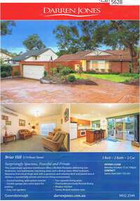
Advertising Leaflet, 3/19 River Street Briar Hill, 23/11/2012
... 3/19 River Street Briar Hill...river street briar hill...3/19 River Street Briar Hill. 3 bedroom home, private sale, sold 23 November 2012 for $445,000...Greensborough Historical Society 34A Glenauburn Road Lower Plenty Lower Plenty melbourne 3/19 River Street Briar Hill. 3 bedroom home, private sale, sold 23 November 2012 for $445,000 river street briar hill Real estate advertising leaflet, 1 sheet, printed in colour both sides 3/19 River Street Briar Hill Advertising Leaflet Darren Jones ...3/19 River Street Briar Hill. 3 bedroom home, private sale, sold 23 November 2012 for $445,000Real estate advertising leaflet, 1 sheet, printed in colour both sidesriver street briar hill -
 Greensborough Historical Society
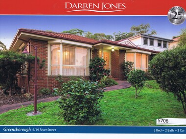
Advertising Leaflet, Darren Jones, 6/19 River Street Greensborough, 28/07/2018
... 6/19 River Street Greensborough...river street greensborough...6/19 River Street Greensborough. Three bedroom unit, sold for $830,000 in July 2018. ...Previous sales: November 1998, $35,000. river street greensborough Real estate advertising leaflet, 1 sheet, printed in colour both sides. 6/19 River Street Greensborough Advertising Leaflet Darren Jones ...6/19 River Street Greensborough. Three bedroom unit, sold for $830,000 in July 2018. Previous sales: November 1998, $35,000.Real estate advertising leaflet, 1 sheet, printed in colour both sides. river street greensborough -
![Photograph - Digital image, 24 River Street [Briar Hill], 02/05/2013](/media/collectors/4f729f5697f83e03086015b8/items/572868fc2162f115acc626a5/item-media/572869462162f115acc630d2/item-fit-380x285.jpg?cb=6) Greensborough Historical Society
Greensborough Historical SocietyPhotograph - Digital image, 24 River Street [Briar Hill], 02/05/2013
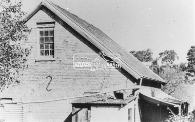
... 24 River Street [Briar Hill]......river street briar hill...This photograph of 24 River Street was taken in 2013 to show changes over 40 years, based on Ron Reynold’s sketches in the 1973 publication “Greensborough and Greenhills” published by Cypress Books....Greensborough Historical Society 34A Glenauburn Road Lower Plenty Lower Plenty melbourne This photograph of 24 River Street was taken in 2013 to show changes over 40 years, based on Ron Reynold’s sketches in the 1973 publication “Greensborough and Greenhills” published by Cypress Books. greensborough and greenhills river street briar hill ron reynolds Digital copy of colour photograph. 24 River Street [Briar Hill] Photograph - Digital image Sue Ballantyne ...This photograph of 24 River Street was taken in 2013 to show changes over 40 years, based on Ron Reynold’s sketches in the 1973 publication “Greensborough and Greenhills” published by Cypress Books.Digital copy of colour photograph.greensborough and greenhills, river street briar hill, ron reynolds -
 Ballarat Heritage Services
Photograph - Video, Clare Gervasoni, Confluence of Canadian Creek and Yarrowee River near Anderson Street, Ballarat, 06/09/2022
... Confluence of Canadian Creek and Yarrowee River near Anderson Street, Ballarat....River...Ballarat...Anderson Street...Video of the confluence of Canadian Creek and Yarrowee River near Anderson Street, Ballarat flowing down a channel....Canadian Creel Yarrowee River Ballarat Anderson Street channel bluestone Video of the confluence of Canadian Creek and Yarrowee River near Anderson Street, Ballarat flowing down a channel. ...The waterways of central Ballarat were channeled to prevent flooding and contain sludge during the mining era.Video of the confluence of Canadian Creek and Yarrowee River near Anderson Street, Ballarat flowing down a channel.canadian creel, yarrowee river, ballarat, anderson street, channel, bluestone -
 Sunshine and District Historical Society Incorporated
Administrative record - City of Sunshine - Commissioner Mr Alexander Alex George Gillon Collection 1976 - 1982 - Intention to move motion at ordinary Meeting 10th March 1981, City of Sunshine, 17th February 1981
... ...River Street...Rosamond Road and River Street Pedestrian Signals...Rosamond Road River Street Maidstone Rosamond Road and River Street Pedestrian Signals Foolscap sized document. ...Rosamond Road and River Street Pedestrian Signalsrosamond road, river street, maidstone -
 Eltham District Historical Society Inc
Photograph, Doug Orford, Mountain View Road, Briar Hill, near River Street, 1991, 1991
... Mountain View Road, Briar Hill, near River Street, 1991...Eltham District Historical Society Inc 728 Main Rd Eltham melbourne From a collection of 35 photos taken by Doug Orford at 35 specific locations along the exact boundary of the then Shire of Eltham. briar hill mountain view road Colour photograph Mountain View Road, Briar Hill, near River Street, 1991 Photograph Photograph Doug Orford ...From a collection of 35 photos taken by Doug Orford at 35 specific locations along the exact boundary of the then Shire of Eltham.Colour photographbriar hill, mountain view road -
 Greensborough Historical Society
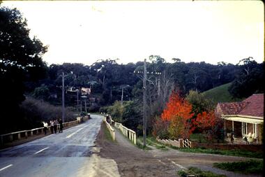
Slide, Fred Harris, Main Street, old river bridge Greensborough, 1949c
... Main Street, old river bridge Greensborough...main street greensborough...plenty river...Taken about 1949, this colour slide shows Main Street Greensborough crossing the Plenty River via the 'old' bridge....Main Street, old river bridge Greensborough Slide Slide Fred Harris ...Taken about 1949, this colour slide shows Main Street Greensborough crossing the Plenty River via the 'old' bridge.1 photographic slide in yellow Kodak packet.Name of donor and title of slide written on outside of packetmain street greensborough, plenty river, main street bridge -
 Brimbank City Council Art Collection
Photograph, Robert Pointon, From Essendon looking west over the Maribyrnong River towards Duke Street Quarries Essendon, early 1990s
... From Essendon looking west over the Maribyrnong River towards Duke Street Quarries Essendon...From Essendon looking west over the Maribyrnong River towards Duke Street Quarries Essendon - AR0017...Brimbank City Council Art Collection The Hunt Club Community Arts Centre 775 Ballarat Road Deer Park melbourne Local Scene From Essendon looking west over the Maribyrnong River towards Duke Street Quarries Essendon - AR0017 From Essendon looking west over the Maribyrnong River towards Duke Street Quarries Essendon Photograph Robert Pointon ...Local SceneFrom Essendon looking west over the Maribyrnong River towards Duke Street Quarries Essendon - AR0017 -
 Greensborough Historical Society
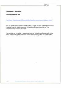
Article and Photograph, Gentlemen's slip away, 2016_
... river street briar hill...Explanation of the term "gentlemen's slip-away", said to refer to the lane at the bottom of River Street Briar Hill which goes to Gladstone Road - a short cut to the Greensborough Hotel?...Any information is the opinion of the contributor. river street briar hill gladstone road briar hill greensborough hotel Article and photograph sourced from social media. ...Explanation of the term "gentlemen's slip-away", said to refer to the lane at the bottom of River Street Briar Hill which goes to Gladstone Road - a short cut to the Greensborough Hotel?This photograph and text was copied from a Facebook site. Members are people who lived in the Greensborough area and share their reminiscences of the area with others. The site is administered by a GHS member but is not officially affiliated with the Society. Any information is the opinion of the contributor. Article and photograph sourced from social media.river street briar hill, gladstone road briar hill, greensborough hotel -
 Eltham District Historical Society Inc
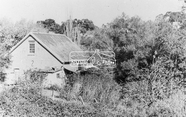
Photograph, Willis Vale on the north bank of the Plenty River, Church Street, Greensborough, c.1950
... Willis Vale on the north bank of the Plenty River, Church Street, Greensborough, c.1950..."Willis Vale, Greensborough, situated on the north bank of the Plenty River at the end of Church Street. The home wasa built about 1840 by Jame Willis Mayger from bricks hand-made nearby. ..., Diamond Valley Story, Greensborough, James Willis Mayger, Partington family, Willis Vale Black and white copy of photo printed on glossy photographic paper 30.5 x 40.5 cm (12 x 16 inch); image size approx. 18.5 x 28 cm Willis Vale on the north bank of the Plenty River, Church Street, Greensborough, c.1950 Photograph Albert Jones ...Photo sourced from Heidelberg Historical Society reproduced on p63 of The Diamond Valley Story by Dianne H. Edwards, Shire of Diamond Valley 1979. "Willis Vale, Greensborough, situated on the north bank of the Plenty River at the end of Church Street. The home wasa built about 1840 by Jame Willis Mayger from bricks hand-made nearby. It was later passed to the Partington family and when this photo was taken the building was deserted. Vandals and finally a bushfire destroyed Willis Vale in the 1950s." Greensborough Historical Society has same image with more accurate information on the date/cause of fire damage https://victoriancollections.net.au/items/585b6c96d0ce2c1268f1c96b "House built by Edward Maygar, Robert Whatmough lived there mid 19th century and later sold to Partington family. It was located on the Plenty River at Partington's Flat Greensborough. The derelict Willis Vale house was destroyed in 1964 when a fire originating from North Plenty Gorge - Kurrak Road - was lit by two teenage boys and made its way several kilometres down to Partington's Flat Greensborough."Black and white copy of photo printed on glossy photographic paper 30.5 x 40.5 cm (12 x 16 inch); image size approx. 18.5 x 28 cmchurch street, diamond valley story, greensborough, james willis mayger, partington family, willis vale -
 Eltham District Historical Society Inc
Photograph, Willis Vale on the north bank of the Plenty River, Church Street, Greensborough, c.1950
... Willis Vale on the north bank of the Plenty River, Church Street, Greensborough, c.1950...Edwards, Shire of Diamond Valley 1979. church street, diamond valley story, greensborough, james willis mayger, partington family, willis vale Black and white copy of photo printed on glossy photographic paper 30.5 x 40.5 cm (12 x 16 inch); image size approx. 18.5 x 28 cm Willis Vale on the north bank of the Plenty River, Church Street, Greensborough, c.1950 Photograph Albert Jones ...Photo probably sourced from Heidelberg Historical Society, Similar photo reproduced on p63 of The Diamond Valley Story by Dianne H. Edwards, Shire of Diamond Valley 1979. Black and white copy of photo printed on glossy photographic paper 30.5 x 40.5 cm (12 x 16 inch); image size approx. 18.5 x 28 cmchurch street, diamond valley story, greensborough, james willis mayger, partington family, willis vale -
 Phillip Island and District Historical Society Inc.
Financial record, Credit account from J.Kennon & Sons for N. L. Smith, Rhyll, 23 March 1914
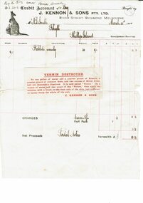
... They were also buyers and exporters of Australian skins and wool.The firm had tanning works,, established in 1863, offices and stores in the vicinity of River Street, Richmond and a leather warehouse in Bridge Road. [ Source -Heritage Victoria https://www.google.com/url?...Kennon & Sons River Street, Richmond...Kennon & Sons River Street, Richmond Cream coloured account with details eg product and amount in black ink. ...J.Kennon & Sons were known particularly for their use of the chrome tanning process. They were also buyers and exporters of Australian skins and wool.The firm had tanning works,, established in 1863, offices and stores in the vicinity of River Street, Richmond and a leather warehouse in Bridge Road. [ Source -Heritage Victoria https://www.google.com/url?sa=t&rct=j&q=&esrc=s&source=web&cd=&cad=rja&uact=8&ved=2ahUKEwiI7OnmofT_AhUia2wGHXNGCaUQFnoECBQQAQ&url=http%3A%2F%2Fimages.heritage.vic.gov.au%2Fattachment%2F24257&usg=AOvVaw0ER8QGZ-3eW4PAg0VM909h&opi=89978449]HistoricalCream coloured account with details eg product and amount in black ink. Includes a separate piece of paper attached to page, with a recipe for vermin destroyer typed in red ink.Credit account of N. L. Smith, Rhyll, Phillip Island. One bag of Rabbit Weevily. March 23, 1914 J. Kennon & Sons River Street, Richmondn.l.smith rhyll, j.kennon and sons, rabbit poison, account, vermin -
 Eltham District Historical Society Inc
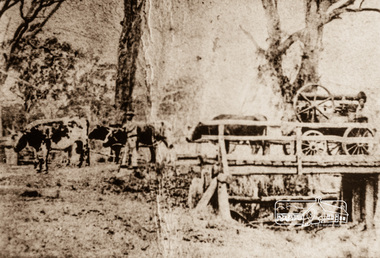
Photograph, Steam engine being hauled by bullock team, possibly over the Plenty River Bridge, Main Street, Greensborough, c.1870, 1870c
... Steam engine being hauled by bullock team, possibly over the Plenty River Bridge, Main Street, Greensborough, c.1870...street...plenty river bridge...Steam engine being hauled by bullock team, possibly over the Plenty River Bridge, Main Street, Greensborough, c.1870 Photograph ...Photograph copy originally located in a magnetic style album titled 'Greensborough Bypass 1990s 5' suffering significant degradation. No information contained in album or on reverse of photos except where noted. Relocated to archival photosafe storage.greensborough, main street, plenty river bridge, steam engine, bullock team -
 Greensborough Historical Society
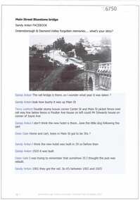
Article and Photograph, Main Street Bluestone bridge, 2017_
... river...main street greensborough...Information and photos about the bluestone bridge over the Plenty River in Main Street Greensborough...Greensborough Historical Society 34A Glenauburn Road Lower Plenty Lower Plenty melbourne Information and photos about the bluestone bridge over the Plenty River in Main Street Greensborough This photograph and text was copied from a Facebook site. ...Information and photos about the bluestone bridge over the Plenty River in Main Street GreensboroughThis photograph and text was copied from a Facebook site. Members are people who lived in the Greensborough area and share their reminiscences of the area with others. The site is administered by a GHS member but is not officially affiliated with the Society. Any information is the opinion of the contributor. Article and photograph sourced from social media.bluestone bridge greensborough, plenty river, main street greensborough -
 Bendigo Historical Society Inc.
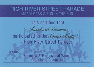
Document - SANDHURST DRUMMERS COLLECTION: CERTIFICATE, 1990
... Blue Participation Certificate for Sandhurst Drummers from Rich River Street Parade 1990....Blue Participation Certificate for Sandhurst Drummers from Rich River Street Parade 1990. Document SANDHURST DRUMMERS COLLECTION: CERTIFICATE ...Documents. Blue Participation Certificate for Sandhurst Drummers from Rich River Street Parade 1990.document, memo, participation certificate -
 Sunshine and District Historical Society Incorporated
Photograph - Maribyrnong High School Gymnasium Photographs
... ...River Street...Maribyrnong High School River Street Maribyrong Maidstone Digital black & white photographs Photograph Maribyrnong High School Gymnasium Photographs ...Maribyrnong High School opened in 1958. The school served in the rapidly growing Maidstone and Maribyrnong districts. During the post war and migration era’s (1950s–1970s), the school became increasingly multicultural due to the nearby Maribyrnong Migrant Hostel (opened 1949) with many European, Middle Eastern, and later Asian migrant students. The school became known for its multicultural student body and union activism in the 1970s. This included the 1971 teacher’s “Control of Entry” strike of 11 weeks, one of the most important industrial actions in Victorian education history that helped to establish the principle that all students must be taught by qualified teachers. The school was later renamed to the Maribyrnong Secondary College and then Maribyrnong College. The school is now well known for its sports academy program. maribyrnong high school, river street, maribyrong, maidstone -
 Sunshine and District Historical Society Incorporated
Photograph - Maribyrnong High School Drama Class Photograph
... ...River Street...Maribyrnong High School River Street Maribyrong Maidstone Digital black & white photograph Photograph Maribyrnong High School Drama Class Photograph ...Maribyrnong High School opened in 1958. The school served in the rapidly growing Maidstone and Maribyrnong districts. During the post war and migration era’s (1950s–1970s), the school became increasingly multicultural due to the nearby Maribyrnong Migrant Hostel (opened 1949) with many European, Middle Eastern, and later Asian migrant students. The school became known for its multicultural student body and union activism in the 1970s. This included the 1971 teacher’s “Control of Entry” strike of 11 weeks, one of the most important industrial actions in Victorian education history that helped to establish the principle that all students must be taught by qualified teachers. The school was later renamed to the Maribyrnong Secondary College and then Maribyrnong College. The school is now well known for its sports academy program. maribyrnong high school, river street, maribyrong, maidstone -
 Mont De Lancey
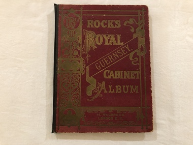
Book, Rock's Royal Guernsey. Cabinet Album
... Mrs Liddy, 59 River Street, Maidstone, Victoria...Mont De Lancey 71 Wellington Road Wandin North yarra-valley-and-dandenong-ranges Mrs Liddy, 59 River Street, Maidstone, Victoria Albums Books Photographs Guernsey A maroon covered album containing Postcard scenes of Guernsey. ...Mrs Liddy, 59 River Street, Maidstone, VictoriaA maroon covered album containing Postcard scenes of Guernsey. Printed in Germany. The title is embossed in gold lettering and pattern on the front cover with a black spine binding.albums, books, photographs, guernsey -
 Eltham District Historical Society Inc
Photograph (Item) - Negative, Mathew Wakefield, Eltham Community Photographic Survey Entry, 1988
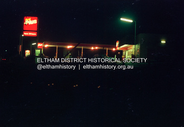
... Street...Eltham...Film - Fuji 100...Main Road...Mathew Wakefield...Scan - 35mm negative...Series 35...Wiingrove Park Trail...Yarra River...It is a time capsule of life in the 1980s of this urban and rural municipality in Melbourne's north. shire of eltham archives Bicentennial Project Eltham Community Photographic Survey Dalton Street Eltham Film - Fuji 100 Main Road Mathew Wakefield Scan - 35mm negative Series 35 Wiingrove Park Trail Yarra River Beard Street Food Plus Service Station Colour 35mm film strip - Fuji 100 Eltham Community Photographic Survey Entry Photograph Negative Mathew Wakefield ...Mathew Wakefield 1988 Entrant No. 40 Ref: Series 34, Items 87, 88 The images in this record were not selected for inclusion. SHIRE OF ELTHAM COMMUNITY PHOTOGRAPHIC SURVEY Photography is an artform which many of us practice, sometimes purely for artistic pursuit, sometimes to record the people and events in our lives. In 1988, as part of a local Bicentennial project, the Shire of Eltham conducted the Eltham Community Photographic Survey. Up to 100 entries were to be selected by a panel of photographers for entry into the Eltham Photographic Survey Exhibition. Entries had to be submitted by May 13, 1988. Entrants whose images were selected for the exhibition were contacted and requested to further submit an entry form providing entrant’s name, area of residence, age, and proposed captions. These details were then used to produce labels for the exhibition mounts. Where negatives had not been supplied, these were requested to support the display of printed enlargements mounted on 10” x 8” cardboard. The mounted prints were made available post exhibition for sale at $8.50 each for colour prints and $7.00 for B&W prints. Residents in the Shire were invited to collect a free roll of film and take a photograph of what they either liked or did not like about the area. A total of 160 entrants submitted multiple entries for the exhibition. Of those selected for exhibition, entrants ranged in age from 9 to 70 years. All custom colour and black and white printing for the exhibition was completed by Wattle Studios of Eltham. The Eltham Photographic Survey was jointly auspiced by the Shire of Eltham and Wattle Studios, of 953 Main Road, Eltham. The project was greatly assisted by: • David McRitchie, Media Studies Lecturer Victoria College, Rusden Campus. • Ian and Annette Toohill of Wattle Studios • Tracy Naughton, Eltham Community Arts Officer • Neville Emerson Pty. Ltd. • Superior Press, Eltham • Kodak Australasia Pty. Ltd. • Agfa Gevaert Ltd. • Townsend Colourtech Pty. Ltd. • The Australian Bicentennial Authority • Eleanor Bowers, Secretary, Eltham Arts Council The exhibition was placed on display in the Woolworths Arcade, Eltham between Monday June 6th and Saturday June 11, 1988. It was also intended to hold the exhibition at a venue in the Shire’s North Riding from Monday, June 20 to Friday June 24. It was then displayed at the Were Street Theatre, Montmorency from Friday, June 24 to Thursday, July 7. Series 34: Eltham Community Photographic Survey 1988 - Prints & Documentation Series consists of 117 photographs of Shire scenes taken by members of the community. Items I - 41 are larger photographs mounted on card, which were exhibited. Items 42 - 117 are unmounted copies, alternative takes and other entries. Corresponding negatives contained in Series 35: Eltham Community Photographic Survey 1988 – Negatives which consists of 267 colour and B&W negatives and one colour slide of Shire scenes taken by members of the community. The negatives are arranged by the entrant number of the photographer. The Eltham Community Photographic Survey collection is significant to the local community as it was curated by the local community - ordinary people of all ages - representing what they liked and did not like in the area where they lived. It represents an unfiltered representation of the Shire of Eltham as it was in 1988. It also represents one of many projects as part of the national programme of events and celebrations to commemorate the bicentenary. It is a time capsule of life in the 1980s of this urban and rural municipality in Melbourne's north. shire of eltham archives, bicentennial project, eltham community photographic survey, dalton street, eltham, film - fuji 100, main road, mathew wakefield, scan - 35mm negative, series 35, wiingrove park trail, yarra river, beard street, food plus service station -
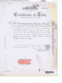 Greensborough Historical Society
Certificate of Title, Supreme Court of Victoria (Probate Division) et al, Certificate of Title Vol. 2567 Fol. 294, Vol. 3134 Fol. 605, 22/05/1895
... grimshaw street greensborough...plenty river...Northern boundary Greensborough Road (now Grimshaw Street), Southern boundary Nell Street, Eastern boundary Plenty River, Western boundary road (now named McDowell Street); Title Vol. 3134 Fol. 605 in the name of Adolphe Frederic Seelenmeyer, land as described above, LP 4759 and transfers and other instruments to 9 March 1948...Northern boundary Greensborough Road (now Grimshaw Street), Southern boundary Nell Street, Eastern boundary Plenty River, Western boundary road (now named McDowell Street); Title Vol. 3134 Fol. 605 in the name of Adolphe Frederic Seelenmeyer, land as described above, LP 4759 and transfers and other instruments to 9 March 1948 greensborough greensborough estate company limited grimshaw street greensborough plenty river nell street greensborough mcdowell street greensborough adolphe frederic seeley, formerly seelenmeyer adolfe frederic seelenmeyer Folder containing two Certificates of Title (3p. + 9 p.) and twenty pages of miscellaneous documents, including historical summary, brief biography of A. ...Title Vol. 2567 Fol. 294 in the name of The Greensborough Estate Company Limited, 164 acres four and a half perches, being part of Crown Portion 17 Parish of Keelbundora, County of Bourke. Dated 22nd May 1895. Northern boundary Greensborough Road (now Grimshaw Street), Southern boundary Nell Street, Eastern boundary Plenty River, Western boundary road (now named McDowell Street); Title Vol. 3134 Fol. 605 in the name of Adolphe Frederic Seelenmeyer, land as described above, LP 4759 and transfers and other instruments to 9 March 1948Folder containing two Certificates of Title (3p. + 9 p.) and twenty pages of miscellaneous documents, including historical summary, brief biography of A. F. Seelenmeyer, two Death Certificates and photocopied extracts from probate documents, as listed in table of contents, ed. by Peter Simmenauergreensborough, greensborough estate company limited, grimshaw street greensborough, plenty river, nell street greensborough, mcdowell street greensborough, adolphe frederic seeley, formerly seelenmeyer, adolfe frederic seelenmeyer -
 Greensborough Historical Society
Article, R. A. Marsh, Church Street Greensborough, 1907_
... river...church street greensborough...Marsh and Partington families are Greensborough pioneer families. marsh family partington greensborough plenty river church street greensborough hailes street greensborough Some handwritten documents. ...Deals with a tenancy agreement between the Marsh and Partington families. In particular a dispute about a log crossing on the Plenty River, the access to which was across Marsh's land. There is also a brief family history of the Marsh family in Greensborough.Marsh and Partington families are Greensborough pioneer families.Collection of documents relating to the Marsh family. Some handwritten documents.marsh family, partington, greensborough, plenty river, church street greensborough, hailes street greensborough -
Federation University Historical Collection
Book, Waterfront Spectacular: Creating Melbourne Docklands - the people's waterfront, 2005
... river...spencer street station...Barker Library (top floor) Mount Helen goldfields docklands vicurban waterfront melbourne architecture engineering town planning marvellous melbourne yarra river spencer street station southern cross station timeline urban renewal port of melbourne art sculpture Large hard covered book of 312 pages. ...Large hard covered book of 312 pages. The book explores the key playerrs in the development of Docklands.docklands, vicurban, waterfront, melbourne, architecture, engineering, town planning, marvellous melbourne, yarra river, spencer street station, southern cross station, timeline, urban renewal, port of melbourne, art, sculpture -
 Sunshine and District Historical Society Incorporated
Photograph - Braybrook Photographs 2021, John Alchin, 2021
... Street...Maribyrnong River...Ballarat Road Ashley Street Beachkey Street Cranwell Street Darnley Street Duke Street Evans Street Gilbert Street Hampden Street Kent Street Lily Street Maribyrnong River Myalla Street South Road 3LO Radio Transmitter Central West Shopping Centre National Springs Ashley Hotel ETA Factory La Porchetta Braybrook Hotel Klipspringer Harkrome Steeden Engineering Sunshine VRI Bowling Club RecWest Kinder Smith Reserve Marj Laffin Salvation Army Hall Quang Minh Buddhist Temple Burke Street Ramon Vila Pavilion Solomon Ford Caroline Chisholm College William Barak Aboriginal Aborigine First Nation Braybrook 5580.01 - Ashley St - Former 3LO - AWA Frequency changing building 2021 Photo 01.JPG 5580.02 - Ashley St 65- 67 Braybrook - Central West Shopping Centre 2021 Photo 02.JPG 5580.03 - Ashley St 185 - 195 Braybrook - Former National Springs 2021 Photo 01.JPG 5580.04 - Ballarat Rd 226 Braybrook - Ashley Hotel Ballarat Rd 2021 Photo 01.JPG 5580.05 - Ballarat Rd 234 Braybrook 2021 Photo 01.JPG 5580.06 - Ballarat Rd 234 Braybrook 2021 Photo 02.JPG 5580.07 - Ballarat Rd 244 - 246 Braybrook 2021 Photo 01.JPG 5580.08 - Ballarat Rd 256 Braybrook - ETA Factory Facade 2021 Photo 02.JPG 5580.09 - Ballarat Rd 256 Braybrook - ETA Factory Facade 2021 Photo 04.JPG 5580.10 - Ballarat Rd 261 Braybrook - La Porchetta 2021 Photo 01.JPG 5580.11 - Ballarat Rd 272 Braybrook - Former Holden Car Dealership 2021 Photo 01.JPG 5580.12 - Ballarat Rd 282 Braybrook 2021 Photo 02.JPG 5580.13 - Ballarat Rd 286 - 288 Braybrook 2021 Photo 01.JPG 5580.14 - Ballarat Rd 288 - 290 Braybrook 2021 Photo 01.JPG 5580.15 - Ballarat Rd 290 - 292 Braybrook 2021 Photo 01.JPG 5580.16 - Ballarat Rd 306 - 308 Braybrook 2021 Photo 01.JPG 5580.17 - Ballarat Rd 353 Braybrook - Braybrook Hotel 2021 Photo 01.JPG 5580.18 - Ballarat Rd 353 Braybrook - Braybrook Hotel 2021 Photo 02.JPG 5580.19 - Ballarat Rd 353 Braybrook - Braybrook Hotel 2021 Photo 03.JPG 5580.20 - Ballarat Rd 353 Braybrook - Braybrook Hotel Blue Stone Bar Sign 2021 Photo 01.JPG 5580.21 - Beachley St 23 - 33 Braybrook - Shops 2021 Photo 01.JPG 5580.22 - Beachley St 23 - 33 Braybrook - Shops 2021 Photo 02.JPG 5580.23 - Braybrook Commons Community Gardens Skinner Reserve 2021 Photo 01.JPG 5580.24 - Cranwell St 40 Braybrook - Klipspringer 2021 Photo 02.JPG 5580.25 - Darnley St 83 Braybrook 2021 Photo 01.JPG 5580.26 - Duke St 144 Braybrook 2021 Photo 01.JPG 5580.27 - Evans St 1 Braybrook - Harkrome Quality Electroplaters 2021 Photo 01.JPG 5580.28 - Evans St 9 Braybrook 2021 Photo 01.JPG 5580.29 - Gilbert St 8 Braybrrok - Steeden Engineering Co Pty Ltd 2021 Photo 01.JPG 5580.30 - Hampden St Factory Demolishment 2021 Photo 01.JPG 5580.31 - Kent St Braybrook - Sunshine VRI Bowling Club 2021 Photo 01.JPG 5580.32 - Kent St Braybrook - Sunshine VRI Bowling Club 2021 Photo 02.JPG 5580.33 - Kent St Braybrook - Sunshine VRI Bowling Club 2021 Photo 03.JPG 5580.34 - Lily st Braybrook - RecWest 2021 Photo 01.JPG 5580.35 - Maribyrnong River Temple to Temple Trail Sign 2021 Photo 01.JPG 5580.36 - Maribyrnong River Braybrook 2021 Photo 01.JPG 5580.37 - Marj Laffin Scoreboard Kinder Smith Reserve Lily St Braybrook 2021 Photo 01.JPG 5580.38 - Myalla St 40 Braybrook - Salvation Army Hall 2021 Photo 01.JPG 5580.39 - Myalla St 40 Braybrook - Salvation Army Hall 2021 Photo 02.JPG 5580.40 - Quang Minh Buddhist Temple Burke St Braybrook 2021 Photo 01.JPG 5580.41 - Quang Minh Buddhist Temple Gardens Braybrook 2021 Photo 04.JPG 5580.42 - Ramon Vila Pavilion Kinder Smith Reserve Lily St Braybrook 2021 Photo 01.JPG 5580.43 - Solomon Ford Maribyrnong River 2021 Photo 01.JPG 5580.44 - South Rd 204 Braybrook - Caroline Chisholm College Braybrook 2021 Photo 01.JPG 5580.45 - South Rd 204 Braybrook - Caroline Chisholm College Quinn Auditorium Braybrook 2021 Photo 01.JPG 5580.46 - William Barak Sign Duke St Reserve Braybrook 2021 Photo 01.JPG Collection of digital photographs Photograph Braybrook Photographs 2021 John Alchin ...Braybrook was originally part of the former Shire of Braybrook and later the City of Sunshine. However, in 1994, Victoria underwent council amalgamations, which resulted in Braybrook being incorporated into the City of Maribyrnong. The suburb of Braybrook continues to attract considerable attention from the residents of City of Brimbank, particularly its historical features, the old buildings and distinctive streetscapes that characterise the area.To capture the essence of Braybrook in 2021, a series of photographs were taken. These images document a range of buildings, street scenes, and other notable points of interest throughout the suburb, providing a visual record of its unique character.5580.01 - Ashley St - Former 3LO - AWA Frequency changing building 2021 Photo 01.JPG 5580.02 - Ashley St 65- 67 Braybrook - Central West Shopping Centre 2021 Photo 02.JPG 5580.03 - Ashley St 185 - 195 Braybrook - Former National Springs 2021 Photo 01.JPG 5580.04 - Ballarat Rd 226 Braybrook - Ashley Hotel Ballarat Rd 2021 Photo 01.JPG 5580.05 - Ballarat Rd 234 Braybrook 2021 Photo 01.JPG 5580.06 - Ballarat Rd 234 Braybrook 2021 Photo 02.JPG 5580.07 - Ballarat Rd 244 - 246 Braybrook 2021 Photo 01.JPG 5580.08 - Ballarat Rd 256 Braybrook - ETA Factory Facade 2021 Photo 02.JPG 5580.09 - Ballarat Rd 256 Braybrook - ETA Factory Facade 2021 Photo 04.JPG 5580.10 - Ballarat Rd 261 Braybrook - La Porchetta 2021 Photo 01.JPG 5580.11 - Ballarat Rd 272 Braybrook - Former Holden Car Dealership 2021 Photo 01.JPG 5580.12 - Ballarat Rd 282 Braybrook 2021 Photo 02.JPG 5580.13 - Ballarat Rd 286 - 288 Braybrook 2021 Photo 01.JPG 5580.14 - Ballarat Rd 288 - 290 Braybrook 2021 Photo 01.JPG 5580.15 - Ballarat Rd 290 - 292 Braybrook 2021 Photo 01.JPG 5580.16 - Ballarat Rd 306 - 308 Braybrook 2021 Photo 01.JPG 5580.17 - Ballarat Rd 353 Braybrook - Braybrook Hotel 2021 Photo 01.JPG 5580.18 - Ballarat Rd 353 Braybrook - Braybrook Hotel 2021 Photo 02.JPG 5580.19 - Ballarat Rd 353 Braybrook - Braybrook Hotel 2021 Photo 03.JPG 5580.20 - Ballarat Rd 353 Braybrook - Braybrook Hotel Blue Stone Bar Sign 2021 Photo 01.JPG 5580.21 - Beachley St 23 - 33 Braybrook - Shops 2021 Photo 01.JPG 5580.22 - Beachley St 23 - 33 Braybrook - Shops 2021 Photo 02.JPG 5580.23 - Braybrook Commons Community Gardens Skinner Reserve 2021 Photo 01.JPG 5580.24 - Cranwell St 40 Braybrook - Klipspringer 2021 Photo 02.JPG 5580.25 - Darnley St 83 Braybrook 2021 Photo 01.JPG 5580.26 - Duke St 144 Braybrook 2021 Photo 01.JPG 5580.27 - Evans St 1 Braybrook - Harkrome Quality Electroplaters 2021 Photo 01.JPG 5580.28 - Evans St 9 Braybrook 2021 Photo 01.JPG 5580.29 - Gilbert St 8 Braybrrok - Steeden Engineering Co Pty Ltd 2021 Photo 01.JPG 5580.30 - Hampden St Factory Demolishment 2021 Photo 01.JPG 5580.31 - Kent St Braybrook - Sunshine VRI Bowling Club 2021 Photo 01.JPG 5580.32 - Kent St Braybrook - Sunshine VRI Bowling Club 2021 Photo 02.JPG 5580.33 - Kent St Braybrook - Sunshine VRI Bowling Club 2021 Photo 03.JPG 5580.34 - Lily st Braybrook - RecWest 2021 Photo 01.JPG 5580.35 - Maribyrnong River Temple to Temple Trail Sign 2021 Photo 01.JPG 5580.36 - Maribyrnong River Braybrook 2021 Photo 01.JPG 5580.37 - Marj Laffin Scoreboard Kinder Smith Reserve Lily St Braybrook 2021 Photo 01.JPG 5580.38 - Myalla St 40 Braybrook - Salvation Army Hall 2021 Photo 01.JPG 5580.39 - Myalla St 40 Braybrook - Salvation Army Hall 2021 Photo 02.JPG 5580.40 - Quang Minh Buddhist Temple Burke St Braybrook 2021 Photo 01.JPG 5580.41 - Quang Minh Buddhist Temple Gardens Braybrook 2021 Photo 04.JPG 5580.42 - Ramon Vila Pavilion Kinder Smith Reserve Lily St Braybrook 2021 Photo 01.JPG 5580.43 - Solomon Ford Maribyrnong River 2021 Photo 01.JPG 5580.44 - South Rd 204 Braybrook - Caroline Chisholm College Braybrook 2021 Photo 01.JPG 5580.45 - South Rd 204 Braybrook - Caroline Chisholm College Quinn Auditorium Braybrook 2021 Photo 01.JPG 5580.46 - William Barak Sign Duke St Reserve Braybrook 2021 Photo 01.JPG ballarat road, ashley street, beachkey street, cranwell street, darnley street, duke street, evans street, gilbert street, hampden street, kent street, lily street, maribyrnong river, myalla street, south road, 3lo radio transmitter, central west shopping centre, national springs, ashley hotel, eta factory, la porchetta, braybrook hotel, klipspringer, harkrome, steeden engineering, sunshine vri bowling club, recwest, kinder smith reserve, marj laffin, salvation army hall, quang minh buddhist temple, burke street, ramon vila pavilion, solomon ford, caroline chisholm college, william barak, aboriginal, aborigine, first nation, braybrook -
 Sunshine and District Historical Society Incorporated
Photograph - Braybrook Photographs 2022, John Alchin, 2022
... Street...Maribyrnong River...Ashley Street Bank Street Breen Street Melon Street Maribyrnong River Cothers Street Rutland Street Scotland Street South Road Braybrook William Barak Aboriginal Aborigine First Nation Invictra Mills Cranwell Park ESP Machinery 5581.01 - Ashley St 75 Braybrook 2022 Photo 01.JPG 5581.02 - Ashley St 75A Braybrook 2022 Photo 01.JPG 5581.03 - Ashley St 87 Braybrook 2022 Photo 01.JPG 5581.04 - Bank St 7 Braybrook 2022 Photo 01.JPG 5581.05 - Bank St Braybrook 2022 Photo 01.JPG 5581.06 - Breen St - Former Invicta Mills Factory 2022 Photo 01.JPG 5581.07 - Breen St - Former Invicta Mills Factory 2022 Photo 04.JPG 5581.08 - Breen St - Former Invicta Mills Factory 2022 Photo 05.JPG 5581.09 - Melon St - Former Invicta Mills Factory 2022 Photo 01.JPG 5581.10 - Maribyrnong River Flooding Cranwell Park 2022 Photo 03.JPG 5581.11 - Maribyrnong River Flooding Cranwell Park 2022 Photo 06.JPG 5581.12 - Maribyrnong River Flooding Cranwell Park 2022 Photo 01.JPG 5581.13 - Maribyrnong River Flooding Cranwell Park 2022 Photo 15.JPG 5581.14 - Crothers St 2 Braybrook 2022 Photo 01.JPG 5581.15 - Rutland St Braybrook 2022 Photo 01.JPG 5581.16 - Scotland St 8 Braybrook 2022 Photo 01.JPG 5581.17 - South Rd - Former Invicta Mills Factory 2022 Photo 02.JPG 5581.18 - South Rd 4 Braybrook - ESP Machinery 2022 Photo 01.JPG 5581.19 - South Rd 14 - 28 Braybrook - ESP Machinery 2022 Photo 02.JPG 5581.20 - South Rd 12 Braybrook 2022 Photo 01.JPG 5581.21 - South Rd 14 - 28 Braybrook - ESP Machinery 2022 Photo 01.JPG 5581.22 - William Barak Sign Duke St Reserve Braybrook 2022 Photo 01.JPG Collection of digital photographs Photograph Braybrook Photographs 2022 John Alchin ...Braybrook was originally part of the former Shire of Braybrook and later the City of Sunshine. However, in 1994, Victoria underwent council amalgamations, which resulted in Braybrook being incorporated into the City of Maribyrnong. The suburb of Braybrook continues to attract considerable attention from the residents of City of Brimbank, particularly its historical features, the old buildings and distinctive streetscapes that characterise the area.To capture the essence of Braybrook in 2022, a series of photographs were taken. These images document a range of buildings, street scenes, and other notable points of interest throughout the suburb, providing a visual record of its unique character.5581.01 - Ashley St 75 Braybrook 2022 Photo 01.JPG 5581.02 - Ashley St 75A Braybrook 2022 Photo 01.JPG 5581.03 - Ashley St 87 Braybrook 2022 Photo 01.JPG 5581.04 - Bank St 7 Braybrook 2022 Photo 01.JPG 5581.05 - Bank St Braybrook 2022 Photo 01.JPG 5581.06 - Breen St - Former Invicta Mills Factory 2022 Photo 01.JPG 5581.07 - Breen St - Former Invicta Mills Factory 2022 Photo 04.JPG 5581.08 - Breen St - Former Invicta Mills Factory 2022 Photo 05.JPG 5581.09 - Melon St - Former Invicta Mills Factory 2022 Photo 01.JPG 5581.10 - Maribyrnong River Flooding Cranwell Park 2022 Photo 03.JPG 5581.11 - Maribyrnong River Flooding Cranwell Park 2022 Photo 06.JPG 5581.12 - Maribyrnong River Flooding Cranwell Park 2022 Photo 01.JPG 5581.13 - Maribyrnong River Flooding Cranwell Park 2022 Photo 15.JPG 5581.14 - Crothers St 2 Braybrook 2022 Photo 01.JPG 5581.15 - Rutland St Braybrook 2022 Photo 01.JPG 5581.16 - Scotland St 8 Braybrook 2022 Photo 01.JPG 5581.17 - South Rd - Former Invicta Mills Factory 2022 Photo 02.JPG 5581.18 - South Rd 4 Braybrook - ESP Machinery 2022 Photo 01.JPG 5581.19 - South Rd 14 - 28 Braybrook - ESP Machinery 2022 Photo 02.JPG 5581.20 - South Rd 12 Braybrook 2022 Photo 01.JPG 5581.21 - South Rd 14 - 28 Braybrook - ESP Machinery 2022 Photo 01.JPG 5581.22 - William Barak Sign Duke St Reserve Braybrook 2022 Photo 01.JPG ashley street, bank street, breen street, melon street, maribyrnong river, cothers street, rutland street, scotland street, south road, braybrook, william barak, aboriginal, aborigine, first nation, invictra mills, cranwell park, esp machinery -
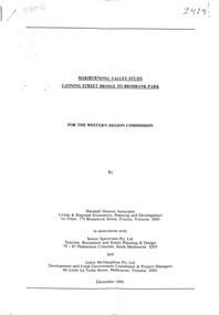 Sunshine and District Historical Society Incorporated
Document - Maribyrnong Valley Study Canning Street Bridge to Brimbank Park December 1990, Henshall Hansen Associates
... River... Canning Street...Maribyrnong Valley Maribyrnong River Canning Street Bridge Typed Report Maribyrnong Valley Study Canning Street Bridge to Brimbank Park December 1990 for the Western Region Commission Maribyrnong Valley Study Canning Street Bridge to Brimbank Park December 1990 Document Maribyrnong Valley Study Canning Street Bridge to Brimbank Park December 1990 Henshall Hansen Associates ...Typed Report Maribyrnong Valley Study Canning Street Bridge to Brimbank Park December 1990 for the Western Region Commissionmaribyrnong valley, maribyrnong river, canning street, bridge -
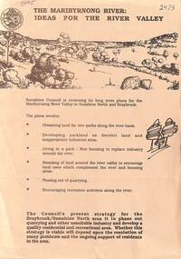 Sunshine and District Historical Society Incorporated
Document - The Maribyrnong River Ideas for the River Valley, City of Sunshine
... River... Canning Street...Maribyrnong Valley Maribyrnong River Canning Street Bridge Flyer The Maribyrnong River Ideas for the River Valley The Maribyrnong River Ideas for the River Valley Document The Maribyrnong River Ideas for the River Valley City of Sunshine ...Flyer The Maribyrnong River Ideas for the River Valleymaribyrnong valley, maribyrnong river, canning street, bridge -
 Port Fairy Historical Society Museum and Archives
Photograph
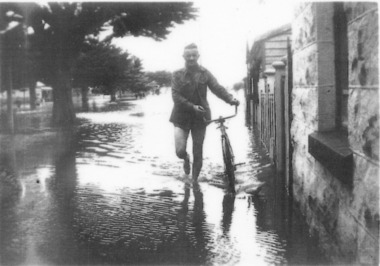
... river...bank street...Port Fairy Historical Society Museum and Archives 30 Gipps Street Port Fairy great-ocean-road evidence of the 1946 floods in Bank Street outside the Keats house in Port Fairy flood river bank street 1946 keats Black and white photograph of Male walking a bicycle on footpath Photograph photograph ...evidence of the 1946 floods in Bank Street outside the Keats house in Port Fairy Black and white photograph of Male walking a bicycle on footpathflood, river, bank street, 1946, keats -
 Port Fairy Historical Society Museum and Archives
Photograph, 1940's
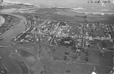
... river...sackville street...The photograph depicts the river, bridge, rail line, Regent Street, Sackville Street, William Street and south west passage and pudney grounds...Port Fairy Historical Society Museum and Archives 30 Gipps Street Port Fairy great-ocean-road The photograph depicts the river, bridge, rail line, Regent Street, Sackville Street, William Street and south west passage and pudney grounds Significant for its depiction of the layout of the town in the 1940's and the river and south west passage moyne river sackville street william street south west passage pudney gorunds ALEX WILKINS PHOTOGRAPHER WARRNAMBOOL O.G.Powell Chemist Phone 88 Port Fairy Handwritten- Aerial View to be enlarged to 12" wide underlined 62.01.006 written on front of picture Black and white photograph Oblique Port Fairy Streets looking South Photograph Photograph Alex Wilkins ...The photograph depicts the river, bridge, rail line, Regent Street, Sackville Street, William Street and south west passage and pudney groundsSignificant for its depiction of the layout of the town in the 1940's and the river and south west passageBlack and white photograph Oblique Port Fairy Streets looking SouthALEX WILKINS PHOTOGRAPHER WARRNAMBOOL O.G.Powell Chemist Phone 88 Port Fairy Handwritten- Aerial View to be enlarged to 12" wide underlined 62.01.006 written on front of picturemoyne river, sackville street, william street, south west passage, pudney gorunds -
 Ballarat Heritage Services
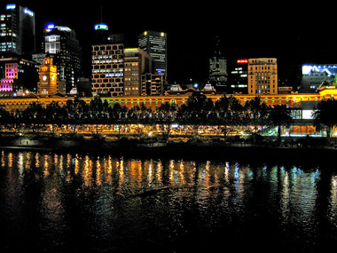
Digital photographs, L.J. Gervasoni, Yarra River rowing at night, c2011
... River...Flinders Street...Ballarat Heritage Services PO Box 2209 Bakery Hill Post Office goldfields Yarra River Flinders Street CBD night rowing Melbourne Yarra River rowing at night Digital photographs L.J. ...yarra river, flinders street, cbd, night, rowing, melbourne -
 Mission to Seafarers Victoria
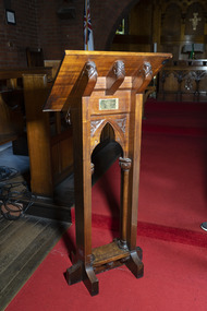
Ceremonial object - Lectern, 1907
... street...yarra river...This lectern underscores the relationship between the Mission and notable Victorians. religion lectern australia-wharf mary georgina howard northcote nee reynell edward northcote (1854-1926) adelaide steamship company henry stafford northcote (1846-1911) g.c.m.g mission to seafarers seamen's mission mission to seamen flinders street yarra river siddeley street heritage listed gifts-1917 Brass plaque on lectern: FOR THE GLORY OF GOD/THIS LECTERN/WAS PRESENTED BY/MARY HOWARD NORTHCOTE/DECEMBER 1907 The head of the lectern is supported by three wooden cross sections each engraved with a criss-crossing leaf pattern. ...The lectern was gifted by Mary Georgina Howard Northcote in December 1907 for the Siddeley Street mission (see Annual Report 1907: list of gifts for the new institute page 8). It was moved to the St Peter Chapel, Flinders Street, and has been in use ever since. Mary nee Reynell in Cheltenham, England, was the wife of Edward Northcote, ex master mariner and general manager of the Adelaide Steamship Company between 1899 and 1926, before his death on 4 November 1926. Edward Northcote was the cousin of Henry Stafford Northcote, Governor General of Australia (1904-1908). Lord Northcote laid the stone of the Siddeley Street Seamen's Institute on Tuesday 5 February 1907. Mary died in December 1932, in her will she made a donation of £25 to the Mission. As it was moved to the St Peter chapel when the Flinders Street Mission opened, it was added to the 1917 list of gifts.The Mission to Seafarers Victoria has been in operation for over 150 years in Victoria although experiencing many name and location changes. Support and patronage by Governors general and State governors was key to official recognition of the work of the Mission.The current site at 717 Flinders Street is the most enduring and many artefacts from previous locations have been relocated to this site. This lectern underscores the relationship between the Mission and notable Victorians.The head of the lectern is supported by three wooden cross sections each engraved with a criss-crossing leaf pattern. The legs of lectern have a similarly carved decorative panel forming an arched shape. Each corner of the panel has gum leafs and nuts carved into it. The foot of the lectern is less ornate although there are three decorated wooden panels mimicking those supporting the head.Brass plaque on lectern: FOR THE GLORY OF GOD/THIS LECTERN/WAS PRESENTED BY/MARY HOWARD NORTHCOTE/DECEMBER 1907religion, lectern, australia-wharf, mary georgina howard northcote nee reynell, edward northcote (1854-1926), adelaide steamship company, henry stafford northcote (1846-1911) g.c.m.g, mission to seafarers, seamen's mission, mission to seamen, flinders street, yarra river, siddeley street, heritage listed, gifts-1917