Showing 659 items matching "road construction building"
-
 Kew Historical Society Inc
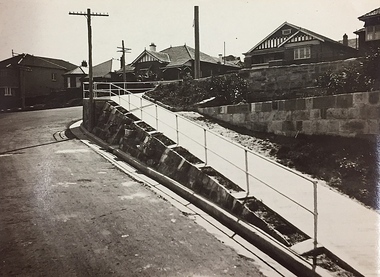
Photograph, City of Kew, Public Works, Road Making, c.1920s
... ...road construction building...They reveal they types of labour conducted, the techniques used and the equipment and machinery in the possession of the local government authority. city of kew (engineering department) engineering road construction building Inscription on reverse: "A difficult corner designed to obviate the use of steps. / Pedestrians using the road in front of the dwellings step off the pathway at the telegraph pole". ...An original photograph donated to the Kew Historical Society by the City's Engineering Department before the amalgamation of Kew into the City of Boroondara in 1994. While not all of the photographs are of Studley Park, Kew or East Kew, each photo provides a fine snapshot of the work of local government engineering departments of the period. They reveal they types of labour conducted, the techniques used and the equipment and machinery in the possession of the local government authority.Public works. A high retaining wall holds back an embankment on a steep slope around which a road turns. It is believed that the photograph dates from the 1920s. Inscription on reverse: "A difficult corner designed to obviate the use of steps. / Pedestrians using the road in front of the dwellings step off the pathway at the telegraph pole".city of kew (engineering department), engineering, road construction building -
 Kew Historical Society Inc
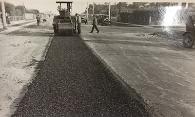
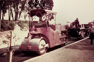
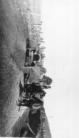
Photograph, City of Kew, Public Works, Road Construction, c.1920s
... ...road construction building...They reveal they types of labour conducted, the techniques used and the equipment and machinery in the possession of the local government authority. steamroller road construction building city of kew city of kew (engineering department) Inscription on reverse: "Road making. (? ...An original photograph donated to the Kew Historical Society by the City's Engineering Department before the amalgamation of Kew into the City of Boroondara in 1994.While not all of the photographs are of Studley Park, Kew or East Kew, each photo provides a fine snapshot of the work of local government engineering departments of the period. They reveal they types of labour conducted, the techniques used and the equipment and machinery in the possession of the local government authority. Public works. A photograph of a suburban street under construction using a steamroller. Neither the street nor the location has been identified. It is believed that the photograph can be dated to the 1920s. Inscription on reverse: "Road making. (?1920s cars)".steamroller, road construction building, city of kew, city of kew (engineering department) -
 Kew Historical Society Inc
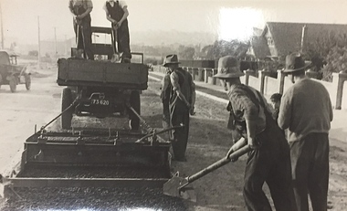
Photograph, City of Kew, Public Works, Road Construction, c.1920s
... road construction building...They reveal they types of labour conducted, the techniques used and the equipment and machinery in the possession of the local government authority. road construction building city of kew city of kew (engineering department) bituminising grader Public works. ...An original photograph donated to the Kew Historical Society by the City's Engineering Department before the amalgamation of Kew into the City of Boroondara in 1994.While not all of the photographs are of Studley Park, Kew or East Kew, each photo provides a fine snapshot of the work of local government engineering departments of the period. They reveal they types of labour conducted, the techniques used and the equipment and machinery in the possession of the local government authority. Public works. A close-up photograph of a grader being pulled by a truck. road construction building, city of kew, city of kew (engineering department), bituminising, grader -
 Kew Historical Society Inc
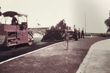
Photograph, Public Works, Road Construction, 1950s
... ...road construction building...They reveal they types of labour conducted, the techniques used and the equipment and machinery in the possession of the local government authority. city of kew (engineering department) road construction building road maintenance Inscription on reverse: "Road making." ...An original photograph donated to the Kew Historical Society by the City's Engineering Department before the amalgamation of Kew into the City of Boroondara in 1994.While not all of the photographs are of Studley Park, Kew or East Kew, each photo provides a fine snapshot of the work of local government engineering departments of the period. They reveal they types of labour conducted, the techniques used and the equipment and machinery in the possession of the local government authority. Public works. Road making in the 1950s using a steam roller and a mechanical grader. Inscription on reverse: "Road making." city of kew (engineering department), road construction building, road maintenance -
 Kew Historical Society Inc
Photograph, Public Works, Road Construction, 1950s
... ...road construction building...They reveal they types of labour conducted, the techniques used and the equipment and machinery in the possession of the local government authority. city of kew (engineering department) road construction building Inscription on reverse: "Road making. ...An original photograph donated to the Kew Historical Society by the City's Engineering Department before the amalgamation of Kew into the City of Boroondara in 1994.While not all of the photographs are of Studley Park, Kew or East Kew, each photo provides a fine snapshot of the work of local government engineering departments of the period. They reveal they types of labour conducted, the techniques used and the equipment and machinery in the possession of the local government authority.Public works. Roadmaking in the 1950s using a steam roller. Inscription on reverse: "Road making. Date?" city of kew (engineering department), road construction building -
 Box Hill Historical Society
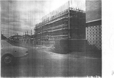
Photograph - Whitehorse Plaza
... Road...Building construction...Box Hill Historical Society Box Hill Heritage Centre Suite 7 Town Hall Hub Box Hill melbourne Construction of Whitehorse Plaza in Whitehorse Road, Box Hill. Looking east along Whitehorse Road Whitehorse Plaza Whitehorse Road Building construction B&w photo Photograph Whitehorse Plaza ...Construction of Whitehorse Plaza in Whitehorse Road, Box Hill. Looking east along Whitehorse RoadB&w photowhitehorse plaza, whitehorse road, building construction -
 Canterbury History Group
Photograph - Building the new Canterbury Baptist Church, 1962
... Road... Churches... Building Construction...Canterbury History Group 190A Canterbury Road Canterbury melbourne Canterbury Canterbury Baptist Church Balwyn Road Churches Building Construction Black and white photograph copied by Jan Pigot from the album kept at the church, of the frame of the new Canterbury Baptist Church in Balwyn Road. ...Black and white photograph copied by Jan Pigot from the album kept at the church, of the frame of the new Canterbury Baptist Church in Balwyn Road.canterbury, canterbury baptist church, balwyn road, churches, building construction -
 Ringwood and District Historical Society
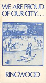
Pamphlet, We Are Proud of Our City - Ringwood (1973), 1973
... Ring 8704311 for guidance on - Town Planning applications, Road and footpath construction, Building matters, Garbage clearance, Connection to sewer by end of 1973, Immunisation times and places, Home help, Rate payments and valuations, Booking of meeting rooms, Clearance of fire hazards, Stray dogs and all nuisance complaints."...Ring 8704311 for guidance on - Town Planning applications, Road and footpath construction, Building matters, Garbage clearance, Connection to sewer by end of 1973, Immunisation times and places, Home help, Rate payments and valuations, Booking of meeting rooms, Clearance of fire hazards, Stray dogs and all nuisance complaints." ...Community information brochure issued in 1973 by Ringwood Council outlining local services, sporting, and cultural facilities. Includes names of Ward Councillors, and two City of Ringwood Free Tipping Vouchers valid until the end of 1974."Frontpiece: A quiet corner of the Fred Dwerryhouse Swimming Centre, Jubilee Park." "The staff at the Civic Centre are at your service. Ring 8704311 for guidance on - Town Planning applications, Road and footpath construction, Building matters, Garbage clearance, Connection to sewer by end of 1973, Immunisation times and places, Home help, Rate payments and valuations, Booking of meeting rooms, Clearance of fire hazards, Stray dogs and all nuisance complaints."rinx -
 Warrnambool and District Historical Society Inc.
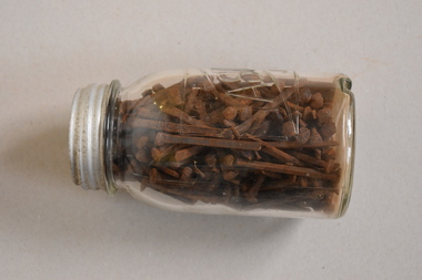
Nails, C1900
... Warrnambool and District Historical Society Inc. 2 Gilles Street (south of Merri St) Warrnambool great-ocean-road Nails such as these were used for building purposes, probably in the construction of house and shed roofs. ...Nails such as these were used for building purposes, probably in the construction of house and shed roofs. The jar has no significance, being a discarded household item used to contain the nails. The nails have no known local provenance but are of interest as they date back over 100 years and are retained to show the type of nails used in the past.This is a glass jar with a ridged base and a metal screw top lid. There is etched printing on one side of the jar. The jar contains many old metal nails, possibly handmade. They are mostly rectangular in shape with flattened heads. There is also at least one metal screw in the jar‘AGEE Mason Jar’antiquarian building materials, warrnambool, history of warrnambool -
 Warrnambool and District Historical Society Inc.
Plumb bob, Early 20th century
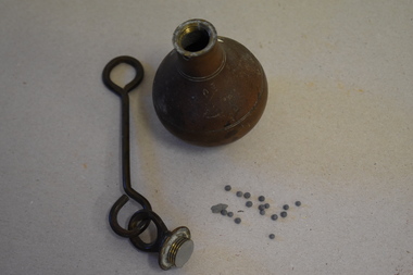
... road A plumb bob or plummet is a weight suspended from a string or rod and used as a vertical reference line or plumb line. It is the vertical equivalent of the water level. It is used to ensure constructions are plumb or level. It has been in use since Egyptian times and is also used in surveying. It is still in use today. This plumb bob weighs 910 grams and was probably used in the building ...A plumb bob or plummet is a weight suspended from a string or rod and used as a vertical reference line or plumb line. It is the vertical equivalent of the water level. It is used to ensure constructions are plumb or level. It has been in use since Egyptian times and is also used in surveying. It is still in use today. This plumb bob weighs 910 grams and was probably used in the building trade. This item is retained as an interesting example of a trade tool from the past.This is a brass weight with a bulbous-shaped body rounded on the bottom, a slender neck and an enclosed top. The top has a metal ring to which is attached a metal rod with a ring at the end. The item is a little stained.building accessories, history of warrnambool -
 Warrnambool and District Historical Society Inc.
Document - Aquarium Information sheet, Circa 1971
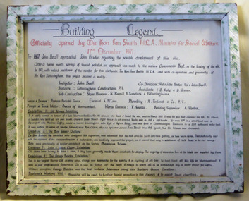
... Warrnambool and District Historical Society Inc. 2 Gilles Street (south of Merri St) Warrnambool great-ocean-road The information on this document shows the inspiration and planning for the building of the aquarium at the Warrnambool breakwater. The instigator was Mr. John Doull, builders Fotheringham Constructions ...The information on this document shows the inspiration and planning for the building of the aquarium at the Warrnambool breakwater. The instigator was Mr. John Doull, builders Fotheringham Constructions and architects, B. Auty and D Jenner. The Aquarium was opened in December 1971 by The Hon Ian Smith MLA. There were four separate exhibitions and galleries listed on the document. The Aquarium closed around 1998.A local landmark in the latter part of the 20th century with the domes being easily recognized. The people involved in its construction were an important part of Warrnambool’s history.Framed document in green and white speckled wooden frame. Hand written in black on white paper. Subline is written in red.warrnambool history, warrnambool aquarium, john doull, fotheringham constructions -
 Kiewa Valley Historical Society
Photographs – Bogong High Plains - Set of 16 black and white photographs mounted back and front on 3 pieces of heavy black card likely removed from a photograph album
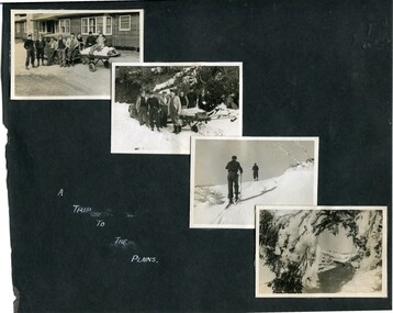
... Some pages display a brief description printed in white ink 1. 4 photographs- displayed diagonally across page. 2 pictures of a group of men standing in the snow in front of a car with a loaded trailer behind. 1 photo of skiers. 1 photo of show hanging in tree branches. 2. 2 photographs- showing Upper Kiewa Road with snow in the background 3. 3 photographs- of skiers and 1 photo of 2 of men posing in the snow & 1 photo of 2 men posing shirtless in warmer weather. 4. 2 photographs- arranged diagonally on page showing early buildings and construction at Bogong Village 5. 2 photographs- 1 showing view of Bogong Village from higher up the mountain. 1 showing early Bogong High Plains road 6. 1 photograph- showing view down along Kiewa Valley from higher up in the mountains ...Some pages display a brief description printed in white ink 1. 4 photographs- displayed diagonally across page. 2 pictures of a group of men standing in the snow in front of a car with a loaded trailer behind. 1 photo of skiers. 1 photo of show hanging in tree branches. 2. 2 photographs- showing Upper Kiewa Road with snow in the background 3. 3 photographs- of skiers and 1 photo of 2 of men posing in the snow & 1 photo of 2 men posing shirtless in warmer weather. 4. 2 photographs- arranged diagonally on page showing early buildings and construction at Bogong Village 5. 2 photographs- 1 showing view of Bogong Village from higher up the mountain. 1 showing early Bogong High Plains road 6. 1 photograph- showing view down along Kiewa Valley from higher up in the mountains Photographs – Bogong High Plains - Set of 16 black and white photographs mounted back and front on 3 pieces of heavy black card likely removed from a photograph album ...After World War II, the Kiewa Hydro-Electric Scheme was started in the Kiewa River Valley by the State Electricity Commission of Victoria. On land previously used only for summer cattle grazing in the natural alpine grasslands, the first ski lodge was built in 1948 by workers from the hydro scheme as skiing was a popular recreation. Many of the hydro employees were of European background and had grown up enjoying skiing and snow sports in their homelands and were keen to continue to pursue their winter sports interests. The first lift, a rope tow, was built at Falls Creek in 1951 and the first chairlift in Australia was constructed there in 1957. Two T-Bars were opened in 1961. In 1964, the Victorian Municipal Directory recorded that Falls Creek had 29 ski club lodges and 16 commercial lodges. The area became a popular tourist destination for both winter and summer sports.Employees of the State Electricity Commission of Victoria in the Kiewa River Valley were the earliest skiers on the Bogong High Plains and built one of the first ski lodges at Falls Creek. They were amongst those pivotal in the development of the skiing and tourist industry at Falls Creek and on the Bogong High Plains. Black and white photographs of varying sizes mounted decoratively on heavy black Card. Some pages display a brief description printed in white ink 1. 4 photographs- displayed diagonally across page. 2 pictures of a group of men standing in the snow in front of a car with a loaded trailer behind. 1 photo of skiers. 1 photo of show hanging in tree branches. 2. 2 photographs- showing Upper Kiewa Road with snow in the background 3. 3 photographs- of skiers and 1 photo of 2 of men posing in the snow & 1 photo of 2 men posing shirtless in warmer weather. 4. 2 photographs- arranged diagonally on page showing early buildings and construction at Bogong Village 5. 2 photographs- 1 showing view of Bogong Village from higher up the mountain. 1 showing early Bogong High Plains road 6. 1 photograph- showing view down along Kiewa Valley from higher up in the mountains 1. Handwritten in white ink – A TRIP TO THE PLAINS 2. Handwritten in white ink – UPPER KIEWA ROAD MT FAINTER IN BACKGROUND 3 – 6. No markings bogong village; upper kiewa road; bogong high plains; falls creek; skiers -
 Kiewa Valley Historical Society
Posters – Set of 3 A4 posters depicting the early days and people in the Kiewa Valley
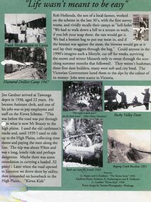
... This resulted in the building of a network of roads which helped open up access to the Alps. The early 1940’s brought the first of many workers to the Alps for the planning and construction of the Hydro-Electric Scheme. ...This resulted in the building of a network of roads which helped open up access to the Alps. The early 1940’s brought the first of many workers to the Alps for the planning and construction of the Hydro-Electric Scheme. ...In the 1830’s, European pastoralists started moving south from NSW into the Alps. In 1836, cattle grazing began around Omeo and the runs spread out into the foothills. The higher country was used for summer grazing and huts were built for shelter and storage during stock mustering. The lure of gold brought many people to the Alps from around 1850 to 1900. Bushfires destroyed the forests around Melbourne in 1939 and the boom in house-building after World War II ked to increased demand for timber from the Alps. This resulted in the building of a network of roads which helped open up access to the Alps. The early 1940’s brought the first of many workers to the Alps for the planning and construction of the Hydro-Electric Scheme. These were the pioneers and early settlers of the Kiewa Valley and provided a wealth of characters and a tapestry of stories and adventures to be handed down to future generations.These 3 posters, which were most likely produced for promotional purposes provide a glimpse into the early lives of the pioneer families of the Kiewa Valley through pictures and verse. They show their lifestyle and outline the hardships they had to endure in living and working in the Alpine region. They also highlight the early arguments regarding grazing in the high country which would ultimately lead to the end of the long traditions of the high country cattle men. Set of 3 A4 size posters with black and white photographs and text and colour background depicting various parts of the history of the Kiewa Valley. 1. Titled - ‘Life wasn’t meant to be easy’ Describes early life for Kiewa Hydro workers. 2. Titled - ‘Cattlemen of the High Plains’ Describes a brief history of life of the cattlemen of the high plains 3. Titled – ‘There are Places I’ll remember’ Depicts early photographs of residents of the Kiewa Valley, also includes the words from a John Lennon song as per poster title. Printed on each poster – Poster designed by Dyanne Photography - Wodonga 1. Printed at bottom of poster – Sources: G Napier and G Easdown “The Kiewa Story” 1993. Southern Hydro Archives, N Hetherington and R Hollands. G Gardner “The Kiewa Kids” 1998. 2. Printed at bottom of poster – Sources: D Purland. Handwritten at top of poster- Poster 4 3. Printed at bottom of poster – Sources: B Roper, W Davies, D Higginson, H Ryder. Handwritten at top of poster- Poster 3 kiewa valley; tourism; lifestyles -
 Kiewa Valley Historical Society
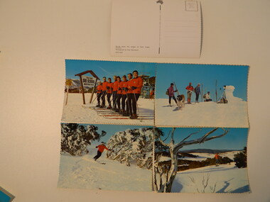
Postcards - Falls Creek - Set of 4
... Roads, buildings including accommodation & chalets, ski clubs, snow vehicles, ski tows etc enabled visitors to live and ski in the snow. When construction ...Postcards were available at tourist destinations to promote the resort by enabling visitors to write to friends and family.The Kiewa Hydro Electric Scheme hastened the development of Falls Creek as a popular destination for skiers. Roads, buildings including accommodation & chalets, ski clubs, snow vehicles, ski tows etc enabled visitors to live and ski in the snow. When construction of the KHES was completed Falls Creek continued to develop both as a winter and summer resort. Serrated edge colored postcards. 1. "On Langlauf Skis in the Australian Snowfields' - Photograph by Uwe Steinward 2. 'Ski-school and instructors at Falls Creek, Victoria' Photograph by Uwe Steinward x2 3. Overlooking the Victorian snowfields, Falls Creek, Victoria' Photograph by Uwe Steinward 4. 'Skiing down the slopes at Falls Creek, Victoria.' photograph by Uwe Steinward x3falls creek, snow, skiing, alpine sport, langlauf skmiing, uwe steinward -
 Kiewa Valley Historical Society
7 small black and white photographs of Pretty Valley, c1948
... roads, constructed and banks and benches at the dam site undertaken. Following the financial crisis in 1951, a review of the scheme was carried out and work ceased in June 1951. Construction of the dam was deleted from the programme of works and all buildings...roads, constructed and banks and benches at the dam site undertaken. Following the financial crisis in 1951, a review of the scheme was carried out and work ceased in June 1951. Construction of the dam was deleted from the programme of works and all buildings ...In 1947 it was proposed to construct a dam on the Pretty Valley branch of the East Kiewa River. This was part of the initial planning in 1937. The Pretty Valley Reservoir was to be part of a pumped-storage scheme with a pumping station located immediately below the main structure. Preparatory work was commenced in 1946 with erection of staff accommodation. Between 1947 and 1950 the main camp was erected, access roads, constructed and banks and benches at the dam site undertaken. Following the financial crisis in 1951, a review of the scheme was carried out and work ceased in June 1951. Construction of the dam was deleted from the programme of works and all buildings removed.A pictorial history of part of the initial planning in 1937 for a dam to be constructed at Pretty Valley as part of the Kiewa Hydro Electric Scheme.7 small black and white photographs of Pretty ValleyAll photos have a circular stamp on the back with 'Print by Willson White Albury' enclosed. Photo 1 - on the back, handwritten in ink 'New 22Kv pump line - Pretty Valley Nov. 1948'. In pencil '18'. Photo 2 - On the back, handwritten in ink 'Pretty Valley - Staff mess on right Nov. 1948'. In pencil '18'. Photo 3 - On the back, handwritten in ink 'Pretty Valley Basin - looking S.E. Nov. 1948'. In pencil '5'. Photo 4 - On the back, handwritten in ink 'New pump 22Kv line, Pretty Valley - looking towards Mt. Mackie. Nov. 1948'. In pencil '5'. Photo 5 - On the back, handwritten in ink 'Pretty Valley. Mt. Cope just out of picture extreme right. Nov. 1948'. In pencil '78'. Photo 6 - on the back, handwritten in ink 'View from Pretty Valley Ruined Castle in Background Nov. 1948'. In pencil '78'. Photo 7 - on the back, handwritten in ink 'Pretty Valley Pump line (Nov. 1948)'. In pencil'78'.construct, dam, pretty valley -
 Kiewa Valley Historical Society
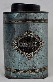
Tin Coffee Cylindrical, circa mid to late 1900's
... This "bulk" buying and storage "syndrome" was a lingering result of many years of "drought" periods when road transports met delays from flooded roadways in supplying population centres in the Kiewa Valley. The construction phases in building the SEC Vic Hydro electricity Scheme in the eastern sections of the Victorian Alps brought many changes to the quiet rural regions in the Kiewa Valley. ...This "bulk" buying and storage "syndrome" was a lingering result of many years of "drought" periods when road transports met delays from flooded roadways in supplying population centres in the Kiewa Valley. The construction phases in building the SEC Vic Hydro electricity Scheme in the eastern sections of the Victorian Alps brought many changes to the quiet rural regions in the Kiewa Valley. ...This "coffee" tin has by the "art deco" appearance its origins in the late 1950's to 1960's. This time period was one of accelerated growth both in the physical (housing) sense and the mental (new ideas and inventions) changes in "attitudes". These occurred more rapidly in cities but had its effects on the rural environment. The drinking of coffee was spurred on by easier distribution of imported food and drinks. Advertising by stronger radio links and then by television brought the variety of foods and drinks to semi isolated rural regions. The accessibility through greater information channels becoming available brought with it unbelievable ranges of goods and foodstuffs. Rural regions still relied on bulk supplies and relatively larger storage containers than those in cities. This "bulk" buying and storage "syndrome" was a lingering result of many years of "drought" periods when road transports met delays from flooded roadways in supplying population centres in the Kiewa Valley. The construction phases in building the SEC Vic Hydro electricity Scheme in the eastern sections of the Victorian Alps brought many changes to the quiet rural regions in the Kiewa Valley. Changes in population and social mores. The influx of a varied , mostly temporary, and "European flavoured cuisine" changes the "cuppa tea only" flavour to the have a "coffee break". The subliminal influence of the "American" films changed those children growing up in the post 1950s from the "English tea" to the "American coffee". This "Americanisation process has influenced not only rural Australia but also other areas throughout the world.This "insignificant" coffee tin is very significant as it demonstrates that the Kiewa Valley was becoming more accessible to reliable coffee supplies and general food items.The container was part of a "set" of containers that included tea, sugar,biscuits,flour, rice and other family condiments. This type of kitchen storage containers was brought about through changing patterns in tea and coffee useage and overall consumption. Household demands for faster "self help" cooking especially beveridges and the greater choice of kitchen "utensils" was brought on by easier access to products due to a lessening of the area's "isolation" by having a reliable (all weather) road system and an ever increasing population growth. The need for travelling goods/merchant supply caravans to service the area became a diminishing factor, as a result of the establishment of grocery stores in Tawonga and Mount Beauty in the supply of previously "hard to get" groceries. This transition was precipitated by the SEC Vic Hydro Scheme of the 1940's to 1960's which increased the valley's population level three fold.This cylindrical tin has a pull/push lid(for easy access to the contents). The container is labelled for "coffee" however it has no commercial manufacturer's label to establish that it was bought with coffee ingredients in it. The majority of the container's external surface has a "metallic" light blue colour with two sets of silver rings confining black (horizontal spotted) rectangles. "COFFEE" within an elongated spherical "art deco" four pointed banner of silver and black colouringkitchen containers, domestic food storage, bulk stocks of dried condiments -
 Kiewa Valley Historical Society
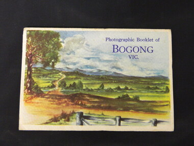
Booklet - Bogong, Photographic Booklet of Bogong Vic
... buildings and equipment being used at the time. Bogong Village housed the State Electricity Commission of Victoria's employees working on the Kiewa Hydro Electric Scheme which began in the 1930's and finished in the 1960's. Maisie describes her visit in May 1958 giving an insight into the area including the weather and the roads. The photos indicate what the area around Bogong looked like c1958 towards the end of construction ...This booklet was produced to advertise Bogong Village and surrounding areas. The photos depict the area's buildings and equipment being used at the time. Bogong Village housed the State Electricity Commission of Victoria's employees working on the Kiewa Hydro Electric Scheme which began in the 1930's and finished in the 1960's. Maisie describes her visit in May 1958 giving an insight into the area including the weather and the roads.The photos indicate what the area around Bogong looked like c1958 towards the end of construction but before the bush grew back after the 1939 fires at Bogong village and after construction of the shopping centre at Mt Beauty. A sno' cat and snow plough are also shown emphasising the change in machinery over the years. This enables comparisons to be made in many areas of study.A fold down booklet postcard size of 9 black and white photos of Bogong village and surrounds and a letter addressed to Mrs. A. Parnell of Sydney from Maisie. Maise's husband has 2 married sisters living near Bogong on farms. The booklet is in a clear plastic sleevePostage stamp arrived in Sydney 28th May 1958.bogong. lake guy. howman gap hostel. mt beauty.bogong high plains. -
 Kiewa Valley Historical Society
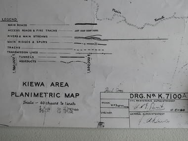
Map - Kiewa Area Planimetric Map
... roads, buildings, and bodies of water. A very clear map showing the Kiewa Hydro Electric Scheme in two dimensions to include the construction done by the SECV. ...Planimetric maps are two-dimensional representations of the Earth's surface, showing the location and spatial arrangement of features such as roads, buildings, and bodies of water.A very clear map showing the Kiewa Hydro Electric Scheme in two dimensions to include the construction done by the SECV.Black and white Map of the Kiewa Area from Mt Beauty to the High Plains covering the Kiewa Hydro Electric Scheme and surrounds. Drawn on 11th May 1966kiewa hydro electric scheme 1966 -
 Kiewa Valley Historical Society
Photo: Making of Kiewa Valley Highway at Tawonga
... Kiewa Valley Historical Society Mount Beauty Information Centre 31 Bogong High Plains Rd Mt Beauty high-country The Kiewa Valley Highway was/is a major road along the Kiewa River ending at Mt Beauty the site of the S.E.C.V. town built for the construction of the K.H.E.S. Kiewa Valley Highway Road building ...The Kiewa Valley Highway was/is a major road along the Kiewa River ending at Mt Beauty the site of the S.E.C.V. town built for the construction of the K.H.E.S.Black and white photo with roofless old car beside two horses pulling a cart with man behind the cart. All coming towards the photographer on a road with paddocks on each side.kiewa valley highway, road building -
 Kiewa Valley Historical Society
Photos - King Family Collection
... road to Bogong ? C. SEC Works D. Industrial buildings with mountains in the background E. Building site with wooden frame and 3 men F. Buildings with power poles G. Building site with lots of huts H. Buildings under construction...road to Bogong ? C. SEC Works D. Industrial buildings with mountains in the background E. Building site with wooden frame and 3 men F. Buildings with power poles G. Building site with lots of huts H. Buildings under construction ...The King family lived in Tawonga South where my older brother and sister went to school. We lived over the road from Wally Madison's farm. Later when a house became available, we moved into Valley Avenue, Mt Beauty. This is when I turned 5 and started my schooling. It was a long walk for a 5 year old as I remember. Then later we moved to 50 Lakeside Ave. I remember we loved living there as it was close to the school, footy ground and kindergarten. My father, Ted King, wad a carpenter and was involved in the building of many houses in Mt Beauty which was the home for the workers on the Kiewa Electric Scheme. So as they are part of the history of Mt Beauty I thought they may be useful to you as part of the history. The tennis photos, I vaguely remember Lou Hoad and Ken Rosewell giving exhibition matches in Mt Beauty. I may stand corrected on this, but I do remember my parents who were keen tennis players themselves were most excited at seeing these famous tennis players. As I was only 9 when we left Mt Beauty to live in Dimboola I still remember the shock of leaving a beautiful mountainous county side and arriving in a flat farming land next to a desert and seeing windmills One thing I do remember from school is, once a week (or fortnight) the teacher used to come around with a jar of little white pills, of which we were all to take. I really don't know what they were?? or for?? I also remember being taught to swim in the freezing cold river by a Mrs Smith who wore black bathers and wore her hair in a bun...... ...I am now in my 70s My father used to also carve intricate trays and jewellery boxes in his spare time. I think they were used for tennis trophies. by Diane Werner.x33 photos of small black and white photos of the Tawonga, Tawonga South and Mt Beauty - Photos not labelled but described as follows. See each photo for a possible label. A. Tawonga? B. Mt Beauty taken on the road to Bogong ? C. SEC Works D. Industrial buildings with mountains in the background E. Building site with wooden frame and 3 men F. Buildings with power poles G. Building site with lots of huts H. Buildings under construction I. Group of houses in the distance J. Group of houses in the distance K. Group of people in front of a building L. Group of 8 men sitting on timber planks, corrugated iron at back. M.& N. Building site with floor and upright timbers O. Mountain view with camp site in foreground P.& Q. Buiding site, several houses R.5 men at a building site S. portable building on trailer T & U. Mountain view V. Building site W. Group of men, car and mountains in background X. Cows Y. Pigs Z. 2 men standing next to cars. AA. Football players BB. Man painting a corrugated iron building CC. Football DD. Men in front of a building EE Buildings with mountains in background FF & GG Tennis payersHH & II. Electricity infrastructure -
 Kiewa Valley Historical Society
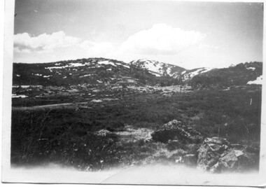
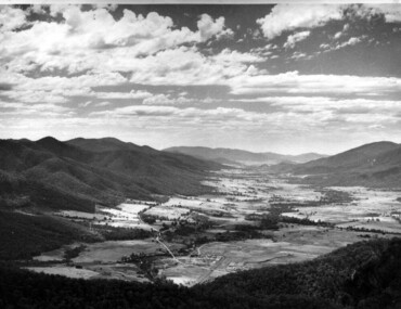
Photograph of Kiewa Valley Panorama, Kiewa Valley from No. 5 Road, Before 1945
... buildings. There is no sign of construction of the town itself. In the latter part of 1945 work was commenced on the Mt. Beauty township area with a medical centre, general trading store and some houses under construction. The No. 5 Road...buildings. There is no sign of construction of the town itself. In the latter part of 1945 work was commenced on the Mt. Beauty township area with a medical centre, general trading store and some houses under construction. The No. 5 Road ...In 1943 a camp for workmen was erected and a commencement made with the erection of plant storage and workshop buildings in the new township of Mt. Beauty. The photograph was probably taken after the completion of these buildings. There is no sign of construction of the town itself. In the latter part of 1945 work was commenced on the Mt. Beauty township area with a medical centre, general trading store and some houses under construction. The No. 5 Road, from where the photograph was taken, is the road to West Kiewa Power Station and Big Hill Scenic Lookout.Is an excellent view of the Kiewa Valley before there was little work undertaken to establish the town of Mt. Beauty. Farming was well established with the evidence of huge areas of cleared land. The junction of the East and West Kiewa Rivers can be clearly seen. The first Workmen's camp is near the river and some workshop buildings can also be seen. Black and white photograph of the Kiewa Valley, looking North.Handwritten on the back of photograph "Kiewa Valley from No. 5 Road".kiewa valley, camp, buildings, mt. beauty -
 Kiewa Valley Historical Society
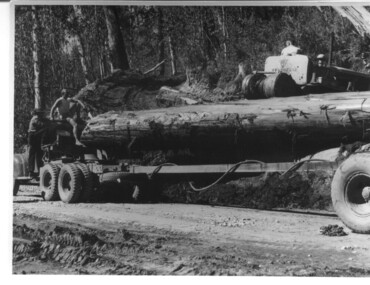
Photograph, logging at McKay Creek, Logging at McKay Creek, 1949/50
... road (a rough, narrow track) was put it in 1948 and widened in 1954. The State Electricity Commission would have milled logs from this area at their mill at Howman's Gap. The timber was used for building of housing and camps and provided a much needed resource as there was a general shortage of this commodity. The power station was relocated underground owing to repeated problems with landslides in the area. Restricted financial resources and the repositioning of the power station retarded construction...road (a rough, narrow track) was put it in 1948 and widened in 1954. The State Electricity Commission would have milled logs from this area at their mill at Howman's Gap. The timber was used for building of housing and camps and provided a much needed resource as there was a general shortage of this commodity. The power station was relocated underground owing to repeated problems with landslides in the area. Restricted financial resources and the repositioning of the power station retarded construction ...This photo was most likely taken at the site of the proposed McKay Creek Power Station. Excavation of this site was commenced in 1951 but an access road (a rough, narrow track) was put it in 1948 and widened in 1954. The State Electricity Commission would have milled logs from this area at their mill at Howman's Gap. The timber was used for building of housing and camps and provided a much needed resource as there was a general shortage of this commodity. The power station was relocated underground owing to repeated problems with landslides in the area. Restricted financial resources and the repositioning of the power station retarded construction activities and it was not completed until early 1961. An historical pictorial record of the type of machinery used in the 1950's - logging truck with bogie attached, the bull dozer and winch for hauling logs to the truck and note the lack of protective clothing!Black and white photograph showing a logging truck, bogie and bull dozer with winch for hauling the logs to the truck. Two men are on the truck, a driver on the bull dozer and a large log on the bogie. Hand written on the back of photo "Logging at McKay Creek".logging, mckay creek, timber, machinery -
 Emerald Museum & Nobelius Heritage Park
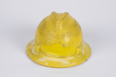
Headwear - Fire Fighters Helmet, MSA, c.1970s
... construction to that of polymer and other plastics. This helmet was donated by the Emerald Fire Brigade which was established on 14 March 1941 as the Emerald Bush Brigade. Originally its equipment was stored at Madigan's butcher's shop near the corner of Monbulk Road. The Brigade's first fire station was built around 1945. In 1966, this station was recorded as containing the fire truck and a Land rover pumper, three radio sets, 40 knapsacks, six lengths of hose, helmets, rake hoes and other hand tools. In 2010, the Brigade moved into a new purpose-built building...construction to that of polymer and other plastics. This helmet was donated by the Emerald Fire Brigade which was established on 14 March 1941 as the Emerald Bush Brigade. Originally its equipment was stored at Madigan's butcher's shop near the corner of Monbulk Road. The Brigade's first fire station was built around 1945. In 1966, this station was recorded as containing the fire truck and a Land rover pumper, three radio sets, 40 knapsacks, six lengths of hose, helmets, rake hoes and other hand tools. In 2010, the Brigade moved into a new purpose-built building ...During the 1960s in Australia, helmets evolved from metal construction to that of polymer and other plastics. This helmet was donated by the Emerald Fire Brigade which was established on 14 March 1941 as the Emerald Bush Brigade. Originally its equipment was stored at Madigan's butcher's shop near the corner of Monbulk Road. The Brigade's first fire station was built around 1945. In 1966, this station was recorded as containing the fire truck and a Land rover pumper, three radio sets, 40 knapsacks, six lengths of hose, helmets, rake hoes and other hand tools. In 2010, the Brigade moved into a new purpose-built building in Monbulk Road. The manufacturer of this helmet, MSA, was founded in 1914 in the USA. MSA began as a mine safety company but since expanded into more general worker protection and safety products. This helmet is an historical artifact worn by members of a crucial volunteer fire fighting service operating in the Emerald district since 1941.Yellow, lightweight, hard plastic or polymer helmet with black leather detachable chin strap with Velcro fastening. inside the helmet is an adjustable head harnessInside helmet on a partly torn label: 'MSA / VGARD / Type 2 ...? / STANDARDS AUSTRALIA' Inside the brim black pen writing EMERALD SPARE 5 EMERALD at one end engraved: 'MSA'' and at the other end: '1801-1881 On the outside of the helmet there is a yellow reflector on each side and at the front and the back there is evidence of labels that have been removed.helmets, fire fighting, msa, emerald fire brigade, cfa -
 Lara RSL Sub Branch
User Handbook, For Heavy Girder Bridge Fixed spans Provisional dition. Part 1 Description and instructions, reprinted November 1955
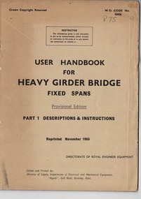
... Edited and printed by Ministry of Supply, Inspection of Electrical Mechanical Equipment, Aquila, Golf Road, Bromley, Kent 65 year old handbook containing instructions on construction/completion building of Heavy Girder Bridge. user handbook heavy girder bridge - fixed spans Crown Copyright reserved, W. ...Printed in the U.K. Edited and printed by Ministry of Supply, Inspection of Electrical Mechanical Equipment, Aquila, Golf Road, Bromley, Kent65 year old handbook containing instructions on construction/completion building of Heavy Girder Bridge.Thin brown fount cover with 50 fawn color internal pages, A4 Crown Copyright reserved, W. O. Code No. 10436. Restricted The information given in this document is not to be communicated, either directly or indirectly, to the press or to any not authorized to receive it. Printed November 1955user handbook, heavy girder bridge - fixed spans -
 Federation University Historical Collection
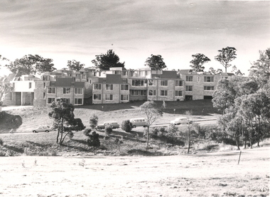
Photograph - Black and White Photographs, Views of Mount Helen Campus, c1973
... construction of Student housing, Union building (later Albert Coates Complex), and a four storey library (later E.J.. Barker Library) on the Mt Helen campus was signed in November and December 1971. They were all completed and occupied in 1973. mount helen campus buildings student residences Views of Mount Helen Campus .1) Signposts of first turnoff campus road from Gear Avenue .2) Mount Helen Student Residences (stage 1) .3) Rear view of Mount Helen Student Residences (Stage 1) Views of Mount Helen Campus Photograph Black and White Photographs ...Ongoing photgraphic record of Mount Helen Campus development. A contract for the construction of Student housing, Union building (later Albert Coates Complex), and a four storey library (later E.J.. Barker Library) on the Mt Helen campus was signed in November and December 1971. They were all completed and occupied in 1973. Views of Mount Helen Campus .1) Signposts of first turnoff campus road from Gear Avenue .2) Mount Helen Student Residences (stage 1) .3) Rear view of Mount Helen Student Residences (Stage 1)mount helen campus, buildings, student residences -
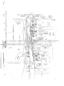
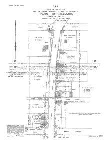 Eltham District Historical Society Inc
Document - Survey Plan, Country Roads Board, SP 6800, Eltham-Yarra Glen Road; Bridge St to Henry St, 1958
... Plan of Survey of Part of Crown Portions 12 and 13 Section 4 Parish of Nillumbik, County of Evelyn Eltham-Yarra Glen Road., Shire of Eltham Shows Surveyor field notes, property ownership and building type and construction....Plan of Survey of Part of Crown Portions 12 and 13 Section 4 Parish of Nillumbik, County of Evelyn Eltham-Yarra Glen Road., Shire of Eltham Shows Surveyor field notes, property ownership and building type and construction. 1958 A.M. ...1958 C.R.B. Plan of Survey of Part of Crown Portions 12 and 13 Section 4 Parish of Nillumbik, County of Evelyn Eltham-Yarra Glen Road., Shire of Eltham Shows Surveyor field notes, property ownership and building type and construction.1958, a.m. gahan, a.s & s.j. davis, annie ellen davies, bridge street, country roads board, d.a. lyon, dave lyon, eltham, flora towell, g.e. gallagher, henry street, j. lyon, k. greene, main road, p.a. gahan, survey plan, w.l. chynoweth pty ltd, york street, neil webster collection -
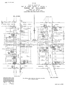 Eltham District Historical Society Inc
Document - Survey Plan, Country Roads Board, SP 6801, Eltham-Yarra Glen Road; Brougham St to Bridge St, 1958
... Plan of Survey of Part of Crown Portion 12 Section 4 Parish of Nillumbik, County of Evelyn Eltham-Yarra Glen Road, Shire of Eltham Shows Surveyor field notes, property ownership and building type and construction....Plan of Survey of Part of Crown Portion 12 Section 4 Parish of Nillumbik, County of Evelyn Eltham-Yarra Glen Road, Shire of Eltham Shows Surveyor field notes, property ownership and building type and construction. ...1958 C.R.B. Plan of Survey of Part of Crown Portion 12 Section 4 Parish of Nillumbik, County of Evelyn Eltham-Yarra Glen Road, Shire of Eltham Shows Surveyor field notes, property ownership and building type and construction.a.j. collis, a.s. & c.g.h. fitzpatrick, board of land & works, bridge street, brougham steet, commonwealth bank of australia, country roads board, eltham, eltham rsl sub-branch, f.h. collis, f.m. smith, f.n. & e.j. burgoyne, franklin street, h.c. & r.e. burgoyne, j. jorgenson, j.f. & j.e. morris, j.n. & h.c. burgoyne, j.s. blow, john street, main road, p.e. smith, pitt street, r.j. dripps, s.j. taylor, survey plan, trustees of the eltham methodist church, 1958, eltham-yarra glen road, neil webster collection -
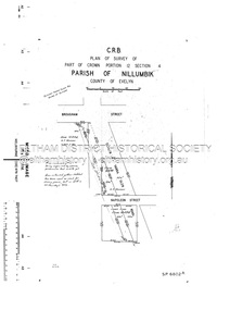 Eltham District Historical Society Inc
Document - Survey Plan, Country Roads Board, SP 6802, Eltham-Yarra Glen Road; Brougham St to Dalton St, 1958
... Plan of Survey of Part of Crown Portion 12 Section 4 Parish of Nillumbik, County of Evelyn Eltham-Yarra Glen Road, Shire of Eltham Shows Surveyor field notes, property ownership and building type and construction....Plan of Survey of Part of Crown Portion 12 Section 4 Parish of Nillumbik, County of Evelyn Eltham-Yarra Glen Road, Shire of Eltham Shows Surveyor field notes, property ownership and building type and construction. 1958 Eltham-Yarra Glen Road A.F. ...1958 C.R.B. Plan of Survey of Part of Crown Portion 12 Section 4 Parish of Nillumbik, County of Evelyn Eltham-Yarra Glen Road, Shire of Eltham Shows Surveyor field notes, property ownership and building type and construction.1958, eltham-yarra glen road, a.f. munday, bible street, brougham steet, country roads board, dalton street, eltham, j.p. & e.a. sanders, j.w. & e. m. graham, l.c. skipper, l.m. jarrold, main road, napoleon street, survey plan, neil webster collection, franco and co -
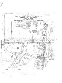 Eltham District Historical Society Inc
Document - Survey Plan, Country Roads Board, SP 6313, Eltham-Yarra Glen Road; Luck St to Henry St, 1956
... Plan of Survey of Part of Crown Portion 13 Section 4 Parish of Nillumbik, County of Evelyn Eltham-Yarra Glen Road, Shire of Eltham Shows Surveyor field notes, property ownership and building type and construction....Plan of Survey of Part of Crown Portion 13 Section 4 Parish of Nillumbik, County of Evelyn Eltham-Yarra Glen Road, Shire of Eltham Shows Surveyor field notes, property ownership and building type and construction. ...1956 C.R.B. Plan of Survey of Part of Crown Portion 13 Section 4 Parish of Nillumbik, County of Evelyn Eltham-Yarra Glen Road, Shire of Eltham Shows Surveyor field notes, property ownership and building type and construction.eltham-yarra glen road, country roads board, eltham, main road, survey plan, 1956, a.l. lyon, a.w. brinkkotter, arthur street, c.r. burkett, dudley street, e.n. staff, eltham war memorial trust, henry street, luck street, pryor street, the board of land & works, the equity trustees executors and agency coy ltd, the roman catholic trusts corporation, victorian railways commision, neil webster collection -
 Eltham District Historical Society Inc
Document - Survey Plan, Country Roads Board, SP 6559-6560, Eltham-Yarra Glen Road; Elsa Ct to Luck St, 1957
... Plan of Survey of Part of Crown Portion 13 Section 4 and Crown Allotment 1 Section 1 Parish of Nillumbik, County of Evelyn Eltham-Yarra Glen Road, Shire of Eltham Shows Surveyor field notes, property ownership and building type and construction....Plan of Survey of Part of Crown Portion 13 Section 4 and Crown Allotment 1 Section 1 Parish of Nillumbik, County of Evelyn Eltham-Yarra Glen Road, Shire of Eltham Shows Surveyor field notes, property ownership and building type and construction. ...1957 C.R.B. Plan of Survey of Part of Crown Portion 13 Section 4 and Crown Allotment 1 Section 1 Parish of Nillumbik, County of Evelyn Eltham-Yarra Glen Road, Shire of Eltham Shows Surveyor field notes, property ownership and building type and construction.eltham-yarra glen road, country roads board, eltham, main road, survey plan, 1957, a.m. & a.a. iowerson, a.mcg. hepburn, cecil street, coffee lounge, diamond street, e.g. murrell, elsa court, h.b. woodhead, j.c. & s.i. harding, la ronde, luck street, r.m. & v.m. white, r.n. mowatt, the board of land & works, w.g. hains, neil webster collection