Showing 72 items matching "road making construction"
-
 Kew Historical Society Inc
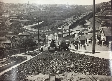
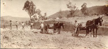
Photograph, City of Kew, Public Works, Road Construction, c. 1920s
... ...road making construction...They reveal they types of labour conducted, the techniques used and the equipment and machinery in the possession of the local government authority. engineering city of kew (engineering department) road making construction Inscription on reverse: "The construction of a roadway in a 1 in 3 1/2 grade. / The waggon is hauling the roller, by means of a cable attached to a pulley anchored at the top of the grade." ...An original photograph donated to the Kew Historical Society by the City's Engineering Department before the amalgamation of Kew into the City of Boroondara in 1994. While not all of the photographs are of Studley Park, Kew or East Kew, each photo provides a fine snapshot of the work of local government engineering departments of the period. They reveal they types of labour conducted, the techniques used and the equipment and machinery in the possession of the local government authority. Public works. A photograph of a suburban street under construction using a steamroller. The street was photographed to demonstrate the issues relating to grading. Neither the street nor the location has been identified. Inscription on reverse: "The construction of a roadway in a 1 in 3 1/2 grade. / The waggon is hauling the roller, by means of a cable attached to a pulley anchored at the top of the grade." engineering, city of kew (engineering department), road making construction -
 Kiewa Valley Historical Society
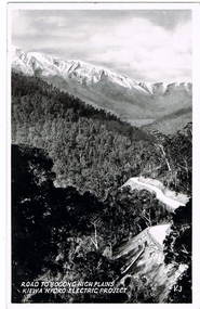
Postcard Circa 1950, Road to Bogong High Plains Kiewa Hydro Electric Project, Circa 1950's
... construction of the Hydro Electricity Scheme. This influx to the regional population resulted in a corresponding diversity in services and brought about an environment that responded to a growing level of tourists and thereby permitting this industry to grow more rapidly than it would have naturally. This postcard details an attraction to the "cleaner" method of providing electricity. This postcard was purchased in 1950 by a surveyor at Landford's Gap. SECV Road making ...This postcard was produced in the 1950's for the tourist trade in the Kiewa Valley and Alpine region. It encompasses the period when the State of Victoria was pressured by the ever increasing demand by industry and its population for electricity supplies. Hydro electricity was seen as an untapped natural resource to quench this demand. The Victorian Alps and the rivers flowing into its valleys was ideal for the construction of the Kiewa Hydro Electricity Scheme. The late 1940's saw the development of this scheme and the changing of sections of alpine landscape is covered by this and other postcards/pictures (tourists, construction workers, and established rural populations). This period in time was before the established wildlife and forest/nature groups became political activist who changed legislative acts to protect the environment.This rural region (Kiewa Valley/alpine plains) was at most only significant to a smaller group of winter sports, summer hikers/horse riders and rural farmers/graziers. The numbers of tourists and the increase in the local resident population was boosted by the construction of the Hydro Electricity Scheme. This influx to the regional population resulted in a corresponding diversity in services and brought about an environment that responded to a growing level of tourists and thereby permitting this industry to grow more rapidly than it would have naturally. This postcard details an attraction to the "cleaner" method of providing electricity. This postcard was purchased in 1950 by a surveyor at Landford's Gap.This black and white photograph on a Valentine's postcard is from a V2 Argus photograph.. It is on a 200g/m paper density photo side gloss. See 0480 (A) - (G) for other photos of similar postcards.In white lettering " ROAD TO BOGONG HIGH PLAINS KIEWA HYDRO-ELECTRIC PROJECT", V3secv, road making, victorian alps -
 Kiewa Valley Historical Society
Photo: Making of Kiewa Valley Highway at Tawonga
... road along the Kiewa River ending at Mt Beauty the site of the S.E.C.V. town built for the construction of the K.H.E.S. Kiewa Valley Highway Road building Black and white photo with roofless old car beside two horses pulling a cart with man behind the cart. All coming towards the photographer on a road with paddocks on each side. Photo: Making ...The Kiewa Valley Highway was/is a major road along the Kiewa River ending at Mt Beauty the site of the S.E.C.V. town built for the construction of the K.H.E.S.Black and white photo with roofless old car beside two horses pulling a cart with man behind the cart. All coming towards the photographer on a road with paddocks on each side.kiewa valley highway, road building -
 Kiewa Valley Historical Society
Black and White photograph of Road Making Machinery, Kiewa Road Making, 25/08/1938
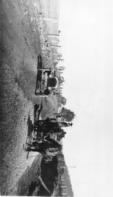
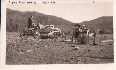
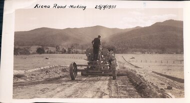
... construction of a bridge 100 feet long. By the end of 1939, the excavation had been 'opened up' for a distance of 19 1/2 miles (approx. 31 km) and of this length, 10 miles (approx. 16 km) had been surfaced. The purchase and use of this type of mechanical equipment in road making ...Construction of the main road from South Tawonga to the Bogong High Plains, to provide access to the construction sites for the new Kiewa Hydro Electric Scheme, was commenced early in 1938, the work being undertaken on behalf of the Commission by the Country Roads Board. For the construction work, the Commission purchased three Caterpillar - model R07 - diesel crawler tractors equipped with Kay Brunerei (Brunner) hydraulically operated trailbuilders (angle dozers). This acquisition resulted from a visit to the United States of America in May, 1937 by the Construction Engineer ( Mr. C.H. Kernot) and Assistant Civil Engineer (Mr. J.F. Douglas) where they saw this relatively new type of equipment in use. With the co-operation of the CRB, the Commission demonstrated the operation of these machines at Fishermen's Bend on 6th April, 1938. They were then sent to Kiewa where they commenced operation towards the end of the month. From South Tawonga, the route led immediately across the Western Branch of the Kiewa River necessitating the construction of a bridge 100 feet long. By the end of 1939, the excavation had been 'opened up' for a distance of 19 1/2 miles (approx. 31 km) and of this length, 10 miles (approx. 16 km) had been surfaced.The purchase and use of this type of mechanical equipment in road making was a huge investment, as prior to this most of the work would have been done manually with the use of picks and shovels. Not only were many months of hard manual labour saved, but a very significant amount of time in providing access to the proposed work sites for the new Kiewa Hydro Scheme. This photo is an excellent reminder of how primitive the early machinery was compared to the present but also represents the forward thinking of the State Electricity Commissions engineers in purchasing such innovative equipment . A black and white photograph showing the type of machinery used for road making in the 1930's. It shows a grader being towed by a caterpillar tractor.On the top left hand corner of the photograph , hand written in black ink is the words 'Kiewa Road Making 25/8/1938'. On the right hand side of the photo has been stamped in blue the Number 1. It has been developed on Velox paper (marked on back of photo) with a gloss finish.road making, state electricity commission, caterpillar tractor, kiewa -
 Kiewa Valley Historical Society
Black and White photograph of Road Making Machinery, Kiewa Road Making 25/08/1938 No. 2, 25/08/1938
... construction of a bridge 100 feet long. By the end of 1939, the excavation had been 'opened up' for a distance of 19 1/2 miles (approx. 31 km.) and of this length, 10 miles (approx. 16 km.) had been surfaced. (see KVHS 0328) The purchase of this type of mechanical equipment in road making ...Construction of the main road from South Tawonga to the Bogong High Plains, to provide access to the construction sites for the new Kiewa Hydro Electric Scheme, was commenced early in 1938, the work being undertaken on behalf of the commission by the Country Roads Board. For the construction work, the Commission purchased three Caterpillar - model R07 - diesel crawler tractors equipped with Kay Brunerei (Brunner) hydraulically operated trailbuilders (angle dozers). This acquisition resulted from a visit to the United States of America in May, 1937 by the Construction Engineer ( Mr. C.H. Kernot) and Assistant Civil Engineer ( Mr. J.F. Douglas) where they saw this relatively new type of equipment in use. With the co-operation of the CRB, the Commission demonstrated the operation of these machines at Fishermen's Bend on 6th April, 1938. They were then sent to Kiewa where they commenced operation towards the end of the month. From South Tawonga, the route let immediately across the Western Branch of the Kiewa River necessitating the construction of a bridge 100 feet long. By the end of 1939, the excavation had been 'opened up' for a distance of 19 1/2 miles (approx. 31 km.) and of this length, 10 miles (approx. 16 km.) had been surfaced. (see KVHS 0328)The purchase of this type of mechanical equipment in road making was a huge investment, as prior to this most of the work would have been done manually with the use of picks and shovels. Not only were many months of hard manual labour saved, but a very significant amount of time in providing access to the proposed work sites for the new Kiewa Hydro Scheme. This photo is an excellent reminder of how primitive the early machinery was compared to the present but also represents the forward thinking of the State Electricity Commissions engineers in purchasing such innovative equipment.A black and white photograph of road making near Mt. Beauty in 1938. Mount Beauty hills can be seen in the background with cleared land for grazing in the fore ground.Hand printed in black ink at the top of the photograph is 'Kiewa Road Making 25/8/1938'. On the right hand corner has been printed the number 2. It has been printed on gloss Velox paper.road making, state electricity commission, caterpillar tractor, kiewa, secv -
 Kiewa Valley Historical Society
Black and White photograph of Road Making Machinery, Kiewa Road Making 25/8/1938(No. 3 in a series of 8), 25/08/1938
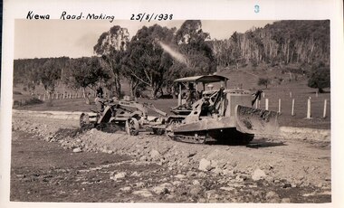
... construction of a bridge 100 feet long. By the end of 1939,the excavation had been 'opened up' for a distance of 19 1/2 miles (approx. 31 km.) and of this length, 10 miles (approx. 16 km) had been surfaced. The purchase and use of this type of mechanical equipment in road making ...Construction of the main road from South Tawonga to the Bogong High Plains, to provide access to the construction sites for the new Kiewa Hydro Electric Scheme, was commenced early in 1938, the work being undertaken on behalf of the Commission by the Country Roads Board. For the construction work, the Commission purchased three Caterpillar - model R07 - diesel crawler tractors equipped with Kay Brunerei (Brunner) hydraulically operated trail builders (angle dozers)). This acquisition resulted from a visit to the United States of America in May, 1937 by the Construction Engineer ( Mr. C.H. Kernot) and Assistant Civil Engineer (Mr. J.F. Douglas) where they saw this relatively new type of equipment in use. With the co-operation of the CRB, the Commission demonstrated the operation of these machines at Fishermen's Bend on 6th April, 1938. They were then sent to Kiewa where they commenced operation towards the end of the month. From South Tawonga, the route led immediately across the Western Branch of the Kiewa River necessitating the construction of a bridge 100 feet long. By the end of 1939,the excavation had been 'opened up' for a distance of 19 1/2 miles (approx. 31 km.) and of this length, 10 miles (approx. 16 km) had been surfaced.The purchase and use of this type of mechanical equipment in road making was a huge investment, as prior to this most of the work would have been done manually with the use of picks and shovels. Not only were many months of hard manual labour saved, but a very significant amount of time in providing access to the proposed work sites for the new Kiewa Hydro Scheme. This photo is an excellent reminder of how primitive the early machinery was compared to the present but also represents the forward thinking of the State Electricity Commission's Engineers in purchasing such new and innovative equipment.A black and white photograph of a Caterpillar diesel crawler tractor and a hydraulically operated trailbuilder (angle dozer) making a road in the Mt. Beauty area.Hand written in black ink in the top left hand corner are the words "Kiewa Road Making 25/8/1938". On the upper right hand of the photograph has been stamped the number 3. On the back is stamped the word 'Velox' severaly times, which is the make of the photograhic paper. roadmaking, caterpillar tractor, kiewa, state electricity commission -
 Kiewa Valley Historical Society
Black and white photograph of farmland, Kiewa, 25/8/38, circa 1938
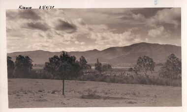
... road construction kiewa tawonga mt. beauty secv Handwritten in black ink on the upper left corner of the photograph is the inscription 'Kiewa 25/8/38' and the number 5 has been stamped on the upper right hand corner. On the back is the word 'Velox' which is the name of the photographic paper on which the photo was developed. A black and white photograph of farmland with Mt. Emu in the background. This has been taken from where Mt. Beauty township now stands prior to road making ...This photograph was taken in August, 1938 some eight years prior to the establishment of Mt. Beauty as a township. The area was still being used for grazing, and the land was eventually acquired from the local land owners by the State Electricity Commission. The construction of the road, from Tawonga to the High Plains, was commenced in April of this year. This allowed men and heavy equipment to be transported to the work sites for the construction of the Kiewa Hydro Electric Scheme This photograph is important as it shows the upper Kiewa Valley as it was before the establishment of the town of Mt. Beauty. The land has been cleared of natural growth and has been used for grazing cattle. By 1946 housing construction had commenced for the new town of Mt. Beauty and by 1948 street construction in the southern part of the town was completed as far as Hill Street.A black and white photograph of farmland with Mt. Emu in the background. This has been taken from where Mt. Beauty township now stands prior to road making and the erection of houses. A line of trees below the hill line indicates the position of the East Kiewa River. (No. 5 in a set of 8) Handwritten in black ink on the upper left corner of the photograph is the inscription 'Kiewa 25/8/38' and the number 5 has been stamped on the upper right hand corner. On the back is the word 'Velox' which is the name of the photographic paper on which the photo was developed.road construction, kiewa, tawonga, mt. beauty, secv -
 Kiewa Valley Historical Society
Black and white photograph of farmland, Kiewa, 25/8/38, circa 1938
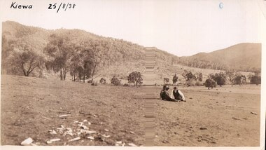
... road making in the area and some eight years prior to the establishment of Mt. Beauty township. The area was still being used for grazing, and the land was eventually acquired from the local land owners by the State Electricity Commission. The construction...road making in the area and some eight years prior to the establishment of Mt. Beauty township. The area was still being used for grazing, and the land was eventually acquired from the local land owners by the State Electricity Commission. The construction ...This photograph was taken in August, 1938 at the time of road making in the area and some eight years prior to the establishment of Mt. Beauty township. The area was still being used for grazing, and the land was eventually acquired from the local land owners by the State Electricity Commission. The construction of the road, from Tawonga to the High Plains, was commenced in April of this year. This allowed men and heavy equipment to be transported to the work sites for the construction of the Kiewa Hydro Electric Scheme. An important photograph as it shows the upper Kiewa Valley as it was before the establishment of the town of Mt. Beauty. The land had been cleared of natural growth and has been used for grazing cattle. By 1946 housing construction had commenced for the new town of Mt. Beauty and by 1948 street construction in the southern part of the town was completed as far as Hill Street.A black and white photograph taken in the upper Kiewa Valley showing farmland with a group of three unidentified people sitting on the grass.Handwritten in black ink is the inscription 'Kiewa 25/8/1938'. In the right corner of the photograph has been stamped the number 6. On the back in a circle, some 14mm across, are the words 'Kodak Print'. The word Velox is also printed on the back.kiewa, mt. beauty, construction, grazing, secv -
 Emerald Museum & Nobelius Heritage Park
Photograph, Mr O'Connor, Making the Road to Clematis, c. 1920
... Road. Public works projects such as road constructions were popular in the immediate aftermath of the First World War, when many men returned home without work and were eager to earn a living by participating in government projects. This image represents an infrastructure project from the 1920s that helped to build the Emerald of today. It displays the tools and technology available for public works projects in the early 20th century, and the manner in which road construction occurred. Emerald Clematis 1920s Transport Rear: "Mr O'Connor / 12 / date / Clematis / Making ...In late 1919, the Country Roads Board approved an amendment of the Belgrave-Emerald Road between Gembrook Road (likely now Old Gembrook Road) in Emerald and Paradise (now Clematis) Station. This image shows part of those works, where they intersected with Ogilvy Road. Public works projects such as road constructions were popular in the immediate aftermath of the First World War, when many men returned home without work and were eager to earn a living by participating in government projects.This image represents an infrastructure project from the 1920s that helped to build the Emerald of today. It displays the tools and technology available for public works projects in the early 20th century, and the manner in which road construction occurred.A sepia photograph on card backing depicting a road construction project. The workers are relying on horses and manual labour to build a road amongst trees and hills. The lower-left corner of the photograph is damaged and faded, with some damage and the photo peeling away from the backing along the left side as a whole. The rear has some handwritten text, with some illegible.Rear: "Mr O'Connor / 12 / date / Clematis / Making the Road to Clematis / 1920?"emerald, clematis, 1920s, transport -
 Emerald Museum & Nobelius Heritage Park
Photograph, Mr O'Connor, Making the Road to Clematis, Original Taken c. 1920
... road construction occurred. Emerald Clematis 1920s Transport N/A A black and white photograph on paper depicting a road construction project. The workers are relying on horses and manual labour to build a road amongst trees and hills. The lower-left corner of the photograph is faded - an artefact from the original that this is a copy of, though this copy was made when more of the original was intact. Making ...In late 1919, the Country Roads Board approved an amendment of the Belgrave-Emerald Road between Gembrook Road (likely now Old Gembrook Road) in Emerald and Paradise (now Clematis) Station. This image shows part of those works, where they intersected with Ogilvy Road. Public works projects such as road constructions were popular in the immediate aftermath of the First World War, when many men returned home without work and were eager to earn a living by participating in government projects. This image is a black-and-white copy of the original sepia photograph (VEMUP0996).This image represents an infrastructure project from the 1920s that helped to build the Emerald of today. It displays the tools and technology available for public works projects in the early 20th century, and the manner in which road construction occurred.A black and white photograph on paper depicting a road construction project. The workers are relying on horses and manual labour to build a road amongst trees and hills. The lower-left corner of the photograph is faded - an artefact from the original that this is a copy of, though this copy was made when more of the original was intact.N/Aemerald, clematis, 1920s, transport -
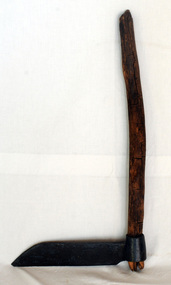 Orbost & District Historical Society
Paling knife, shingle froe, c. 1870s - 1930s
... Road in c. 1890. Peter Jensen came from Denmark. shingle-making roofing-shingles house-construction BRADES CO. ...Likely used by the Jensen family who were early settlers in the Martin's Creek area, 35 miles north of Orbost, along the Bonang - Orbost Road in c. 1890. Peter Jensen came from Denmark. A flat iron blade, sharpened on the bottom and attached to a wooden handle. The blade has a pointed end.BRADES CO.shingle-making roofing-shingles house-construction -
 Flagstaff Hill Maritime Museum and Village
Nail, circa 1810
... The incident of the fire on board and the bravery of the convicts in making the gun powder safe is an example of the social character of the people in early Tasmanian colonisation. flagstaff hill warrnambool shipwrecked coast flagstaff hill maritime museum maritime museum shipwreck coast flagstaff hill maritime village great ocean road george iii ship construction ship nail 1835 shipwreck 19th century shipwreck william moxey d'entrecasteaux channel convict transportation copper nail dumpy bolt spike keel nail Copper nail (also called a Dumpy bolt or spike) from the convict ship George III, wrecked in 1835. ...This copper nail, sometimes known as a ‘Dumpy Bolt’ or spike, was salvaged from the hull of the wreck of the “George III”. It dates back to at least 1810. It was found by an abalone diver on the south east coast of Tasmania. The nail would have been used to hold the layers of the ship’s keel frame and the planking together. The nail has been passed from the abalone diver to an interested business man on a trip to the south of Hobart, on again to the business man’s close friend who then donated it to Flagstaff Hill Maritime Village. The metal of nails such as this one, after being in the sea for a long time, become affected by the natural reaction of the sea water, causing it to degenerate and thin, and the stress from the force of the sea over the years alters its shape. Iron nails had been used on ships previously, but they quickly corroded in the salt; ships needed regular, costly and time-consuming maintenance to replace the iron nails. Towards the end of the 18th century the British Navy trialled the use of copper nails, finding them to be very successful. Merchant ships began to adopt this process in the early 19th century, although it made ship building very expensive and was more often used for ships such as the “George III” that sailed on long voyages. The three masted sailing ship “George III” was a convict transport ship built in Deptford, England, in 1810. On 14th December 1834 she left Woolwich, England, bound for Hobart Town, Van Diemen’s Land (Tasmania), under Captain William Hall Moxey. She was carrying 220 male convicts plus crew, guards and their families, totalling 294 persons (another 2 were during the voyage). Amongst the cargo were military stores including several copper drums of gun powder. On 27th January 1835 the “George III” was near the Equator, about half way into her journey. A fire broke out and the gun powder was in danger of explosion, threatening the whole ship. Two convicts braved the heat and smoke, entered the store and seized the gun powder drums, suffering burns for their efforts but saving a probable disaster. The fire destroyed some of the provisions and food was scarce. Many became ill with scurvy and some died during the journey. Nearing the end of their journey on 10th April 1835 the “George III” was headed through the D'Entrecasteaux Channel, south east Tasmania, between the mainland and Bruny Island. She was sailing in the moonlit night to hasten her arrival in port due to the great number of sick on board. She struck uncharted rocks, known only to the local whalers, between Actaeon Reef and Southport Lagoon and within hours began to break up. The ship’s boats were used to first rescue the women and children. Firearms were used to help quell the panic of the convicts below decks and some were killed by the shots. Many convicts, including the sick, were drowned. In all, 133 lives were lost including 5 of the crew, guards and their families. It was the third worst shipping disaster in Tasmanian waters. A monument in honour of the prisoners who perished in the “George III” has been erected, noting the date of the wreck as “Friday 10th April 1835.” (NOTE: there are a few differences between sources regarding dates of the shipwreck, some saying March and others April 1835. There are also differences in the figures of those on board and the number of lives lost.) The copper nail is significant as an example of sailing ship construction; fasteners used in the early 19th century on ships carrying convicts to Australia. The nail is also significant for its association with the ship “George III”. The “George III” is registered on the Australian National Shipwreck Database, ID 7195 as an Historic Shipwreck. She is the third worst shipwreck in Tasmanian waters. She is also associated with Early Australian History and the transportation of convicts to Australia. The incident of the fire on board and the bravery of the convicts in making the gun powder safe is an example of the social character of the people in early Tasmanian colonisation. Copper nail (also called a Dumpy bolt or spike) from the convict ship George III, wrecked in 1835. Nail is long, bent in an ‘L’ shape about 3/5ths along, tapering from both ends to the bend. Both ends are flat and do not taper to a point, nor have a thread. The shorter end has been polished, showing bright copper. There is pitting along the nail and virdigris is evident on the longer, unpolished end. The nail is displayed with the longer section resting on a wooden board between two ‘U’ shaped uprights, the shorter section upright. flagstaff hill, warrnambool, shipwrecked coast, flagstaff hill maritime museum, maritime museum, shipwreck coast, flagstaff hill maritime village, great ocean road, george iii, ship construction, ship nail, 1835 shipwreck, 19th century shipwreck, william moxey, d'entrecasteaux channel, convict transportation, copper nail, dumpy bolt, spike, keel nail -
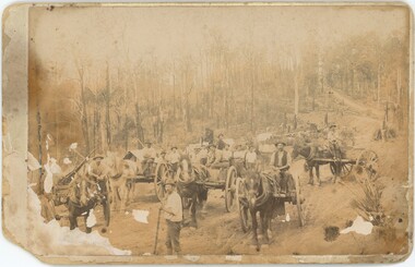
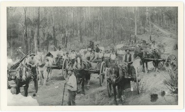
 The Beechworth Burke Museum
Photograph, Late 1800s
... Road Construction...Beechworth Roads...1800s...1800s Beechworth...Beechworth Hills...Horse and Cart...Beechworth Road Making...This photograph is historically significant as it provides insight into the rapid expansion of roads in and around Beechworth during the second half of the nineteenth century. Road Construction Beechworth Roads 1800s 1800s Beechworth Beechworth Hills Horse and Cart Beechworth Road Making Beechworth Council Roads Road Expansion Beechworth Surrounding Hills Reverse: BMM 2982 / Sepia rectangular photograph on matte photographic paper mounted on card Photograph Photograph E.J. ...This photograph depicts six men and two horses with carts in the process of constructing a road. The men each stand in a relatively relaxed position, posing for the camera. However, the amount of upturned soil surrounding them suggests the hard work they have endured, armed only with pitchforks and shovels. The creation of new roads in the Beechworth area had become a priority for the Beechworth council in the second half of the nineteenth century. This included connecting roads which radiated out of Beechworth to surrounding towns. This led to the expansion of the local government authority over the surrounding countryside, greatly strengthening Beechworth's central position. The use of horse and cart to take away the removed soil, as well as the style of the men's attire, suggests that this photograph dates back to the late 1800s. It can also be assumed that this photograph was taken somewhere in the surrounding hills of Beechworth. This photograph is historically significant as it provides insight into the rapid expansion of roads in and around Beechworth during the second half of the nineteenth century. Sepia rectangular photograph on matte photographic paper mounted on card Reverse: BMM 2982 / road construction, beechworth roads, 1800s, 1800s beechworth, beechworth hills, horse and cart, beechworth road making, beechworth council roads, road expansion, beechworth surrounding hills -
 The Beechworth Burke Museum
Geological specimen - Feldspathic Sandstone
... Sandstone features prominently in public buildings throughout Victoria, making this specimen special as it shows the materials used by Victorian building companies. Sandstone can also be crushed, crushed stone is used in the construction of roadways and road structures such as bridges, and in buildings, both commercial and residential. ...Feldspathic arenites are sandstones that contain less than 90% quartz, and more feldspar than unstable lithic fragments, and minor accessory minerals.Feldspathic sandstones are commonly immature or sub-mature.These sandstones occur in association with cratonic or stable shelf settings. Feldspathic sandstones are derived from granitic-type, primary crystalline, rocks. If the sandstone is dominantly plagioclase, then it is igneous in origin Sandstone features prominently in public buildings throughout Victoria. Most of the sandstone used as dimension stone in the State came from three sources: the Heatherlie quarry in the Grampians (Silurian), the Bacchus Marsh area (Permian), and the Barrabool Hills near Geelong (Cretaceous).Sandstone features prominently in public buildings throughout Victoria, making this specimen special as it shows the materials used by Victorian building companies. Sandstone can also be crushed, crushed stone is used in the construction of roadways and road structures such as bridges, and in buildings, both commercial and residential. This specimen is part of a larger collection of geological and mineral specimens collected from around Australia (and some parts of the world) and donated to the Burke Museum between 1868-1880. A large percentage of these specimens were collected in Victoria as part of the Geological Survey of Victoria that begun in 1852 (in response to the Gold Rush) to study and map the geology of Victoria. Collecting geological specimens was an important part of mapping and understanding the scientific makeup of the earth. Many of these specimens were sent to research and collecting organisations across Australia, including the Burke Museum, to educate and encourage further study. A feldspar-rich sandstone, a sandstone intermediate in composition between an arkosic sandstone and a quartz sandstone, containing 10% to 25% feldspar and less than 20% matrix material of clay, sericite, and chlorite. Feldspathic arenite containing less than 90 percent of the composition of quartz. Feldspar is the main composition. Feldspathic arenite may contain fragments of unstable rock, and a little amount of other minerals such as mica and heavy minerals. Some feldspathic arenite have pink or red color because of the presence of potassium feldspar or iron oxide. There are also colored light gray to white. These sandstones are usually medium to coarse grained and can contain a high percentage of granules with angular until subangular roundness. The content of the matrix can appear as the rest up to more than 15 percent, and sorting of grains can present as moderate to poorly sorted. Feldspathic sandstones are generally immature in textural maturity. Feldspathic arenite can not be judged from the structure of the sediment. Bedding can emerge from the laminate parallel to the crossbed. Fossils may appear in the layer deposited on the sea. Feldspathic arenites usually appear on the craton or the continental shelf, which can be associated with conglomerate, quartz lithic arenite, carbonate rock, or evaporites. This sandstone may also appear on the succession of sedimentary basins deposited on an unstable or deep sea, and moving arc setting. According to Pettijohn (1963) Arkose make up about 15 percent of all sandstones. Some Arkose formed in situ when the granite and related rocks disintegrate and generate granular sediments. Most of the material feldspathic sandstones derived from primary crystalline granitic rocks, such as granite or metasomatic rocks containing abundant potassium feldspar. Mineral contained in sandstones is mostly a form of plagioclase feldspar derived from quartz diorite or volcanic rock. Feldspar contained on this sandstone comes from arid to cool climates when the chemical weathering process is reduced.sandstone, natural stone, feldspathic sandstone, burke museum, geology, geological, geological specimen -
 Greensborough Historical Society
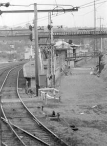
Photograph - Digital Image, Upgrades to Greensborough Station 1970, 1970_
... Greensborough Historical Society 34A Glenauburn Road Lower Plenty Lower Plenty melbourne Photograph of construction of the new station at Greensborough. The existing track can be seen plus construction of a second track, making the station an island platform. ...Photograph of construction of the new station at Greensborough. The existing track can be seen plus construction of a second track, making the station an island platform. The new station was opened on 03/04/1970.Digital copy of black and white photograph. trains, greensborough railway station -
 Halls Gap & Grampians Historical Society
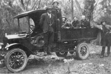
Photograph - B/W, C 1930s
... Photo shows construction workers involved with the making of Dunkeld/Grampians Road. One man is standing on the running board of a small truck, six men are seated or standing in the tray, another man is standing on the ground at the back of the vehicle....Halls Gap & Grampians Historical Society Centennial Hall 117-119 Grampians Road Halls Gap grampians ACCESS ROUTES Roads PEOPLE Road Gang Photo shows construction workers involved with the making of Dunkeld/Grampians Road. ...Photo shows construction workers involved with the making of Dunkeld/Grampians Road. One man is standing on the running board of a small truck, six men are seated or standing in the tray, another man is standing on the ground at the back of the vehicle.access routes, roads, people, road gang -
 Lorne Historical Society
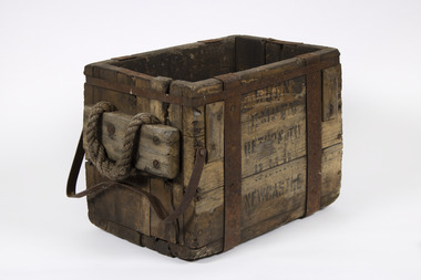
Tool - Blasting Box, 1930 to 1950s
... Lorne Historical Society Lorne Community House Mountjoy Parade Lorne great-ocean-road Blasting box used to store explosives for making of the Great Ocean Road . Great Ocean Road Construction tools explosives Indecipherable writing, just a few words. “ T empt,” “ Newcastle” means, "When Empty Return to BHP Newcastle" Rectangular wooden box without lid. ...Blasting box used to store explosives for making of the Great Ocean Road .Rectangular wooden box without lid. Metal bindings and bracing Rope handle each end and a metal handle at one end . Black writing on each side. Indecipherable writing, just a few words. “ T empt,” “ Newcastle” means, "When Empty Return to BHP Newcastle"great ocean road construction, tools, explosives -
 Eltham District Historical Society Inc
Document - Property Binder, 836 Main Road, Eltham
... construction refered to by Luther Haley in court were situated on the western side of Main Road, near the railway station slightly opposite present day Arthur Street. It was opened around September 1902 as a General Store, Bakery and Tea Rooms. In June 2024 Annie Hackrath shared a memory of living in the old bakery: "My husband and I lived in the old bakery for 18 months in 1978-9 , husband Geoff used the old bakery out the back as a wood workshop, making turnery and handcrafted furniture. ...construction refered to by Luther Haley in court were situated on the western side of Main Road, near the railway station slightly opposite present day Arthur Street. It was opened around September 1902 as a General Store, Bakery and Tea Rooms. In June 2024 Annie Hackrath shared a memory of living in the old bakery: "My husband and I lived in the old bakery for 18 months in 1978-9 , husband Geoff used the old bakery out the back as a wood workshop, making turnery and handcrafted furniture. ...Newspaper article: Was woman found in well put in it? Diamond Valley Local, 16 February 1954, story of wife of baker found in well before Burgoyne family purchased bakery. Newspaper article: Bakery goes ... locals protest, The Valley Voice, 18 July 1979, Joh Ebeli protests about planned destruction, history of building memories of Alistair Knox. Note on demolition of Eltham Bakery building, 1979, by Joh Ebeli who tried to save front of house with friend names Elwers. Photocopy newspaper article: Murder mystery at bakery, History comes to life for old building, 4 November 1979, Harry Burgoyne remembers his grandfather John James Thomas Neville Burgoyne bought bakery in 1896 at time of body found in well, bakery build 1860-1864, sold in 1921. Photocopy newspaper article: Public meeting called over Eltham restaurant proposal, Diamond Valley News, 4 October 1988, protests re proposal for motel and restaurant. Photocopy newspaper article: Fresh tales at an old mine, Diamond Valley News, 4 October 1988, Ausminde Pty Ltd applied for renewal of exploration licence at Old Tree Hill Mine, last mined by Stan Bone and Bill Wallace, photograph of Russell Yeoman at site. Photocopy of line drawing, The Bakery, by Joh Ebeli, 1978. Photocopy of photograph, Old Bakery, next to house built 1880. Photocopy of photograph with Old Bakery in background. On August 12, 1902, appearing before T. Smallman, Esq,. Police Magistrate, and Messrs. W. Duncan and W.J. Taylor, Justices of the Peace is Luther Haley, baker. Wilfred Henry Johnston, by his agent Stanley Ernest Elder had applied for a warrant of ejectment under the Landlord and Tenant Act 1890 against Luther Haley from the bakery premises at the corner of Main Road and York Street. From the evidence presented it is made known that Mrs Burgoyne of Eltham had purchased the property some months earlier from Mr Johnston, which consisted of a store and bakery establishment at Eltham occupied by Mr. Luther Haley, and whose lease expired some little time back, and up to the present time, Mr. Haley was not prepared to leave. He informed the court that he was unable to secure at Eltham a suitable house in which to carry on his business, but he was building a place near the railway station which he expected to be done in about three weeks time, at which time he would give up possession of the bakery. Mr Smallman informed the defendant, Luther Haley, that he would have to quit the premises in three weeks from the present date, and that a warrant of ejectment would be issued. However he also informed Mr Haley that he would order the warrant to lie in the office for three weeks from that date. The premises under construction refered to by Luther Haley in court were situated on the western side of Main Road, near the railway station slightly opposite present day Arthur Street. It was opened around September 1902 as a General Store, Bakery and Tea Rooms. In June 2024 Annie Hackrath shared a memory of living in the old bakery: "My husband and I lived in the old bakery for 18 months in 1978-9 , husband Geoff used the old bakery out the back as a wood workshop, making turnery and handcrafted furniture. The front shop was operated as a “sometimes” art gallery which we called “Gouge and Grain”. There were old sheds against the back fence which we thought were probably stables from the bakery days. Lovely memories of the old place which had so much character and seemed to attract a multitude of interesting creative people! Sad that it was pulled down; a friend salvaged some of the lead light glass in the old doors and included it in a new door panel for us."main road, eltham, property, shops, businesses, eltham bakery, burgoyne family, joh ebeli, alistair knox, harry burgoyne, john james thomas neville burgoyne, one tree hill mine, stan bone miner, bill wallace miner, russell yeoman, henry rech, ausminde pty ltd, john street, bridge street, judy paynter, art gallery, gouge and grain, annie hackrath, geoff hackrath -
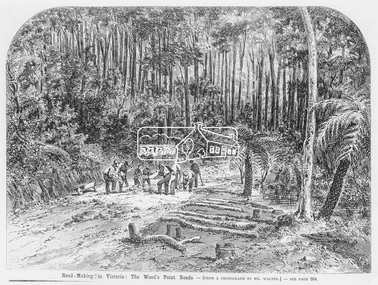 Eltham District Historical Society Inc
Photograph, Illustrated Melbourne Post, Road-making in Victoria. The Wood's Point Roads, 1866
... It is significant in being the first community sourced collection representing the places and people of the Shire's first one hundred years. sepp shire of eltham pioneers photograph collection Other Areas Road construction Woods Point Digital image Print 16.5 x 22 cm (Held at Eltham Library) Road-making in Victoria. ...Reproduced from "Illustrated Melbourne Post" 18 April 1866This photo forms part of a collection of photographs gathered by the Shire of Eltham for their centenary project book,"Pioneers and Painters: 100 years of the Shire of Eltham" by Alan Marshall (1971). The collection of over 500 images is held in partnership between Eltham District Historical Society and Yarra Plenty Regional Library (Eltham Library) and is now formally known as the 'The Shire of Eltham Pioneers Photograph Collection.' It is significant in being the first community sourced collection representing the places and people of the Shire's first one hundred years.Digital image Print 16.5 x 22 cm (Held at Eltham Library)sepp, shire of eltham pioneers photograph collection, other areas, road construction, woods point -
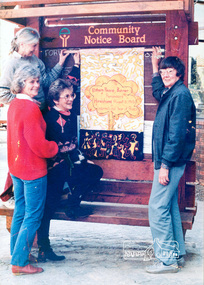 Eltham District Historical Society Inc
Photograph, Ron Grant, The Eltham Peace Group hanging the Hiroshima Day Banner on the Community Notice Board, Arthur Street, Eltham; Community Arts 1986 'As We Are' Banner Project Group, Hiroshima Day, 6 August 1986
... making kimonos to wear when carrying the banner, participating in the Palm Sunday March, an observance of Hiroshima Day activity, which is yet to be decided, establishing contact with a sister-town in USA and USSR and supporting Eltham Council's stance as a Nuclear Free Zone. (The banner habits of the Eltham tribes : Eltham Shire "as we are" Community Banner Project report / by Jacky Talbot, Shire of Eltham, Feb. 1987, p46) Used in Shire of Eltham display at the Eltham Community Festival, 7 November 1987. Shire of Eltham Engineering Department Providing the resources to undertake • Survey, design, consultation • Road construction...making kimonos to wear when carrying the banner, participating in the Palm Sunday March, an observance of Hiroshima Day activity, which is yet to be decided, establishing contact with a sister-town in USA and USSR and supporting Eltham Council's stance as a Nuclear Free Zone. (The banner habits of the Eltham tribes : Eltham Shire "as we are" Community Banner Project report / by Jacky Talbot, Shire of Eltham, Feb. 1987, p46) Used in Shire of Eltham display at the Eltham Community Festival, 7 November 1987. Shire of Eltham Engineering Department Providing the resources to undertake • Survey, design, consultation • Road construction ...Arthur Street, Eltham next to ANZ Bank The Hiroshima Day Banner was made by Jacky Talbot as part of the project. The women wanted to do something for Hiroshima Day and suggested that a workshop be set aside to make a banner. The artist was concerned about the remaining time scheduled for the project and spent several days "whipping" up the banner herself. For the artist this banner was to prove quite significant. The women hung it at the Community Notice Board on Hiroshima Day and were photographed by the local newspaper publicising the group and drawing wider community attention to the remembrance of the day. Although no new members joined the group from this activity, the artist felt that she was more fully accepted by the group afterwards. This banner has initiated a small group of women committed to peace. The artist has also continued to liaise and meet with the women as time permits. Future group plans include: making kimonos to wear when carrying the banner, participating in the Palm Sunday March, an observance of Hiroshima Day activity, which is yet to be decided, establishing contact with a sister-town in USA and USSR and supporting Eltham Council's stance as a Nuclear Free Zone. (The banner habits of the Eltham tribes : Eltham Shire "as we are" Community Banner Project report / by Jacky Talbot, Shire of Eltham, Feb. 1987, p46) Used in Shire of Eltham display at the Eltham Community Festival, 7 November 1987. Shire of Eltham Engineering Department Providing the resources to undertake • Survey, design, consultation • Road construction and maintenance • Bridge construction and maintenance • Street sweeping • Drain and pit cleaning • Traffic engineering installation and maintenance • Garbage collection • Tip management, land reclamation and beautification • Maintenance of community buildings • Provision of community and recreation facilitiesIllustrative of services provided by former Shire of ElthamColour photograph 20 x 29 cm mounted on green-painted chipboard 28 x 35.5 cm (string on back for hanging) Ref: 01842-0Title printed on label adhered to board below photograph (replaced June 2017)display panel, eltham festival, eltham peace banner, hiroshima day banner, infrastructure, shire of eltham, laurel eckersall, anne laurence, betty johnson, joan maclagan -
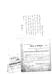 Eltham District Historical Society Inc
Document, Photocopy of receipts
... Roads Construction Receipt, Shire of Eltham for payment by W. McDonald on account of liability to construction of Greensborough Railway Station Estate private roads 2. Receipt for road making...Roads Construction Receipt, Shire of Eltham for payment by W. McDonald on account of liability to construction of Greensborough Railway Station Estate private roads 2. Receipt for road making ...1. Private Roads Construction Receipt, Shire of Eltham for payment by W. McDonald on account of liability to construction of Greensborough Railway Station Estate private roads 2. Receipt for road making of Rattray Road, 13 March 1965Digital file only scanned by EDHS from item on loan (photocopy only)greensborough railway station estate, i. mcdonald, private roads, rattray road, receipt, road construction, w. mcdonald -
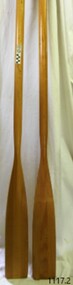 Flagstaff Hill Maritime Museum and Village
Equipment - Rowing Oars
... road The family-owned timber manufacturing business Pelco was started by Cecil Victor Woodfield in 1937. The joinery company Pelco began by making wooden ladders and was registered as the Palmerston Extension Ladder Company. C V Woodfield, who lived from 1884 -1959, arrived in Palmerston North from Canterbury NZ in the aftermath of the Great Depression to work in construction. ...The family-owned timber manufacturing business Pelco was started by Cecil Victor Woodfield in 1937. The joinery company Pelco began by making wooden ladders and was registered as the Palmerston Extension Ladder Company. C V Woodfield, who lived from 1884 -1959, arrived in Palmerston North from Canterbury NZ in the aftermath of the Great Depression to work in construction. The company got its first step up when Woodfield was asked by a commercial painter to make a ladder, and the founder set up shop in a garage on Ruahine St. According to the company website, Pelco made its name in New Zealand with its Oregon Extension Ladders, and up until its closure, manufactured non-conductive Lamilite Ladders for the electrical supply and service industry worldwide. The company was incorporated as a joinery business in 1946, and continued making high-end cabinetry for seven decades. Under director Geoff Woodfield, in the 1950s, the company embarked on the production of Fleetcraft plywood boats. Another water-related enterprise followed, with the manufacture of oars and paddles Its branded Gull Superior Oars and Paddles business began exporting in 1972 to Australia and subsequently to the United States, UK and Japan. The company ceased trading in April 2018 and was placed into receivership.This pair of lightweight oars represents the maritime tradition of handmade oar making, which has evolved over the centuries. Their shape is still similar to early oars and continues to serve the same purpose, to steer and propel a boat. The oars are associated with a significant family business situated in Palmerston New Zealand that along with making ladders also graduated into making wooden boats and oars.Pair of blonde varnished Tasman Fir oars with a flattened paddle at one end. Made by Gull of New Zealand, sold by James Edwards & Sons of Melbourne. Inscriptions on printed labels on the oars.(1) "GULL Superior Oars and Paddles, Pelco, Palmerston North NZ" (2) "JAS. EDWARDS & SONS, Boat Builders, Oar and Skull Makers, & Importers, PRINCES BRIDGE MELBOURNE"warrnambool, flagstaff-hill, flagstaff-hill-maritime-museum, maritime-museum, shipwreck-coast, flagstaff-hill-maritime-village, oar, oars, gull oars and paddles, new zealand oars and paddles, jas edwards and sons melbourne, rowing equipment, new zealand oak, paddle, james edwards and sons melbourne, james edwards, tasman fir, gull superior oars, marine equipment, marine technology, ship fitting, boat fitting, rowing oar, boat oar -
 Glenelg Shire Council Cultural Collection
Slide - Slide - Cashmore Airport, Portland, 1980s
... Glenelg Shire Council Cultural Collection History House Cliff Street Portland great-ocean-road Portland Airport Cashmore engineering air travel construction Coloured slide. Road making equipment working in bottom of excavation. ...Coloured slide. Road making equipment working in bottom of excavation.portland airport, cashmore, engineering, air travel, construction -
Glenelg Shire Council Cultural Collection
Slide - Slide - Construction Portland/Cashmore Airport, c. 1980
... Several road-making vehicles. Clouds of dust. Slide Slide - Construction Portland/Cashmore Airport ...Coloured slide. Run-way site. Several road-making vehicles. Clouds of dust. -
 Geelong RSL Sub Branch
History of Colin Quin, Late 20th Century
... Geelong RSL Sub Branch 50 Barwon Heads Road Belmont geelong-and-the-bellarine-peninsula Colin Quin was a National Serviceman in the 1958 intake upon completion of National Service Colin Quin joined the Regular Army. Colin served with the 21st Construction Engineers the unit went to Wewak, Borneo. After Military Service Colin worked as a refrigeration mechanic and has the interesting hobby of making ...Colin Quin was a National Serviceman in the 1958 intake upon completion of National Service Colin Quin joined the Regular Army. Colin served with the 21st Construction Engineers the unit went to Wewak, Borneo. After Military Service Colin worked as a refrigeration mechanic and has the interesting hobby of making model aeorplanes from beer cans. Colin Quin is also a distant relative to Ned Kelly.This is the original story of Colin Quin.A detailed A4 paper discription of Colin Quin a National Serviceman in 1958 and commenced training in the 20 National Service Battalion. Colin Quinn and joined the Regular Army after completion of National Service. -
Glenelg Shire Council Cultural Collection
Photograph - Photograph - Main Breakwater construction, Portland, n.d
... Glenelg Shire Council Cultural Collection History House Cliff Street Portland great-ocean-road Port of Portland Authority Archives Port of Portland Archives main breakwater construction Portland Harbour harbour development Battery Point Black and white photo, looking towards Battery Point. Several site huts in background at foot of Battery Point. Concrete making ...Port of Portland Authority Archivesport of portland archives, main breakwater, construction, portland harbour, harbour development, battery point -
Glenelg Shire Council Cultural Collection
Photograph - Photograph - Main Breakwater construction, Portland, n.d
... Glenelg Shire Council Cultural Collection History House Cliff Street Portland great-ocean-road Port of Portland Authority Archives Port of Portland Archives main breakwater construction harbour development Black and white photo. Stacks of concrete piles, with one pointed end. Metal forms for making ...Port of Portland Authority Archivesport of portland archives, main breakwater, construction, harbour development -
Glenelg Shire Council Cultural Collection
Photograph - Photograph - Lee Breakwater, Portland, n.d
... Glenelg Shire Council Cultural Collection History House Cliff Street Portland great-ocean-road Port of Portland Authority Archives Port of Portland Archives Lee Breakwater construction concrete Black & white photo of a piece of equipment on the Lee Breakwater. A pile of bags of cement on right. (perhaps this is a concrete making ...Port of Portland Authority Archivesport of portland archives, lee breakwater, construction, concrete -
Glenelg Shire Council Cultural Collection
Photograph - Photograph - Lee Breakwater, Portland, n.d
... Glenelg Shire Council Cultural Collection History House Cliff Street Portland great-ocean-road Port of Portland Authority Archives Port of Portland Archives Henty Beach construction Fishermans Breakwater raft marine maritime Black & white photo of the north end of Henty Beach. There are a number of pipes lying on the sand, on the right of the photo. On the left there are rows of drums, some have been made into rafts. Several men in the water making ...Port of Portland Authority Archivesport of portland archives, henty beach, construction, fishermans breakwater, raft, marine, maritime -
Glenelg Shire Council Cultural Collection
Photograph - Photograph - Portland Harbour, n.d
... Glenelg Shire Council Cultural Collection History House Cliff Street Portland great-ocean-road Port of Portland Authority Archives Port of Portland Archives harbour construction Black & white photo of large machine for making concrete. ...Port of Portland Authority Archivesport of portland archives, harbour, construction