Showing 3849 items matching "road maps"
-
 Bendigo Historical Society Inc.
Map - Road maps
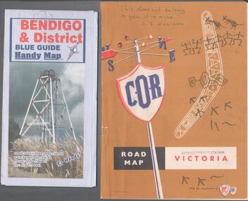
... Road maps...Road Map...Two road maps. On, Bendigo & District blue guide handy map the other a road map of Victoria. ...Map Road maps ...BHS CollectionTwo road maps. On, Bendigo & District blue guide handy map the other a road map of Victoria. On the back of the Bendigo map the date October 2000. On the Victoria map the words in pen "This doesn't belong to you, it is mine". L.J. Ellison and a blue stamp of Axedale service station. Aileen and John Ellison Collection.road map, victoria, bendigo -
 Bendigo Historical Society Inc.
Map - Three Road Maps of Bendigo, 1962
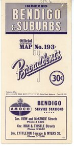
... Three Road Maps of Bendigo...Next year he issued a road map of Victoria, 'prepared … after some sixteen years riding and touring in all parts of the Colony', which indicated general topography, distances, and roads classified as 'good', 'fair' or 'ridden with difficulty'. ...Three Road Maps of Bendigo, Bendigo and Suburbs, Bendigo and Eaglehawk. ...One map printed by Bolton's Bendigo. Map Three Road Maps of Bendigo ...George Robert Broadbent (1863-1947), cyclist and map publisher, was born on 3 November 1863 at Ashby near Geelong, Victoria, son of George Adam Broadbent, Lancashire-born draper, and his wife Elizabeth, née Ruffhead. When the family moved to North Melbourne Broadbent attended the Errol Street school, followed his father's trade, and became an early cycling and cycle-racing enthusiast. At various times Broadbent held most Victorian and Australian road records, and two of his performances on solid tyres—203 miles (327 km) in 24 hours on a penny farthing, and 100 miles (161 km) in 6 hours 20 minutes on a 'safety' bicycle—were never bettered. He established records for all distances between 130 and 220 miles (209 and 354 km), and for all times between 8 and 12 hours, at the Exhibition Grounds track in May 1894, and road records for 50 and 100 miles (80 and 161 km) in October 1896. The Australian Cyclist acknowledged him 'the finest road rider that Australia has ever produced'. A foundation councillor of the League of Victorian Wheelmen in October 1893, Broadbent contested the first Warrnambool-Melbourne race in 1895, and was active in the Good Roads Movement. Next year he issued a road map of Victoria, 'prepared … after some sixteen years riding and touring in all parts of the Colony', which indicated general topography, distances, and roads classified as 'good', 'fair' or 'ridden with difficulty'. It was to become Victoria's standard map, and the basis of a continuous publishing programme by Broadbent's Official Road Guides Co.Three Road Maps of Bendigo, Bendigo and Suburbs, Bendigo and Eaglehawk. Two fold out maps printed in colour and produced by Broadbent's Road Maps Pty. Ltd. 475 Collins Street Melbourne. One map printed by Bolton's Bendigo.history, bolton's, bendio broadbent maps -
 Greensborough Historical Society
Road Maps, The Herald Road Guide, 1955-1956
... Road Maps...Book of road maps, 271 pages, in brown plastic carry case....The Herald Road Guide Road Maps Herald Sun ...Contains maps of Melbourne and surrounding areas as well as routes from Melbourne to other state capitals.Contains maps and descriptions of the Melbourne area in the era before the large scale urbanisation after 1960. Also includes country and day tour maps before highways were common.Book of road maps, 271 pages, in brown plastic carry case.maps, melbourne, victoria, day tours, touring maps -
 Greensborough Historical Society
Map, Broadbent's, Greensborough, 1953_
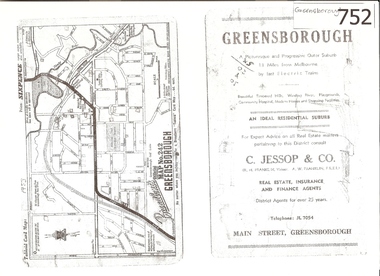
... ...map no 242...road...This road map was a part of a Broadbent's Melbourne suburban directory from 1953....A 1 page photocopy of a road map of Greensborough from 1953....Real estate advertisement greensborough c jessop broadbents map no 242 road maps 1953 Nil A 1 page photocopy of a road map of Greensborough from 1953. ...This road map was a part of a Broadbent's Melbourne suburban directory from 1953.It shows the lay out of Greensborough's streets in 1953.It also shows some different street names to those used today. It also features a C Jessop & Co. Real estate advertisementA 1 page photocopy of a road map of Greensborough from 1953.Nilgreensborough, c jessop, broadbents, map no 242, road maps, 1953 -
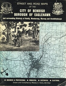 Bendigo Historical Society Inc.
Book - STREET AND ROAD MAPS OF THE CITY OF BENDIGO BOROUGH OF EAGLEHAWK, c1980
... STREET AND ROAD MAPS OF THE CITY OF BENDIGO BOROUGH OF EAGLEHAWK...Street and Road Maps of the City of Bendigo Borough of Eaglehawk and surrounding Districts of Huntly, Mandurang, Marong and Strathfieldsaye, in color. ...Book STREET AND ROAD MAPS OF THE CITY OF BENDIGO BOROUGH OF EAGLEHAWK ...Street and Road Maps of the City of Bendigo Borough of Eaglehawk and surrounding Districts of Huntly, Mandurang, Marong and Strathfieldsaye, in color. Drawn and compiled by Wesley C Harry, Bendigo. Publisher: Cambridge Press, Bendigo. ISBN: 9598608.2.2. 68 pages. Photographs, Illustrations & maps. Photos include: Bendigo buildings, scenery mines, streetscapes, parades, pioneer leaders of Bendigo. Many advertisements throughout. List of Justices of the Peace, hospitals, homes for the aged, schools, churches. Page 58: Copy of ''Freedom of the City to the Australian Survey Regiment'' proclamation, 14th June 1970. Maps cover an area of some 169 sq. miles (43,772 hectares). Origin of the name Bendigo. Information on the five Wards of Bendigo, and their councilors.Wesley C Harrybook, bendigo, bendigo & district maps, bendigo and districts map, buildings, streetscapes, historical pictures, advertisements, historical information, commisioners camp, sandhurst -
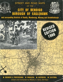 Bendigo Historical Society Inc.
Book - STREET AND ROAD MAPS OF THE CITY OF BENDIGO BOROUGH OF EAGLEHAWK, c1980
... STREET AND ROAD MAPS OF THE CITY OF BENDIGO BOROUGH OF EAGLEHAWK...Street and Road Maps of the City of Bendigo Borough of Eaglehawk and surrounding Districts of Huntly, Mandurang, Marong and Strathfieldsaye, in color. ...Revised Edition 1986 Book STREET AND ROAD MAPS OF THE CITY OF BENDIGO BOROUGH OF EAGLEHAWK ...Street and Road Maps of the City of Bendigo Borough of Eaglehawk and surrounding Districts of Huntly, Mandurang, Marong and Strathfieldsaye, in color. Drawn and compiled by Wesley C Harry, Bendigo. Publisher: Cambridge Press, Bendigo. ISBN: 9598608.2.2. 68 pages. Photographs, Illustrations & maps. Photos include: Bendigo buildings, scenery mines, streetscapes, parades, pioneer leaders of Bendigo. Many advertisements throughout. List of Justices of the Peace, hospitals, homes for the aged, schools, churches. Page 58: Copy of ''Freedom of the City to the Australian Survey Regiment'' proclamation, 14th June 1970. Maps cover an area of some 169 sq. miles (43,772 hectares). Origin of the name Bendigo. Information on the five Wards of Bendigo, and their councilors. Revised Edition 1986Wesley C Harrybook, bendigo, bendigo & district maps, bendigo and districts map, buildings, streetscapes, historical pictures, advertisements, historical information, commisioners camp, sandhurst -
 Dutch Australian Heritage Centre Victoria
Road Map, Nederland
... Road Map...Cleverly folded 1:250,000 road map produced in Dutch, French, German and English containing not only the Dutch road network but also much information of interest to tourists. ...Falk Plan. Road Map. Netherlands. Repeated in Dutch, French and German....Optimal ease of use through patented Falk folding mode. Nederland Road Map ...Cleverly folded 1:250,000 road map produced in Dutch, French, German and English containing not only the Dutch road network but also much information of interest to tourists. It is enclosed in a brown imitation leather cover that closes with a stud. Optimal ease of use through patented Falk folding mode.Falk Plan. Road Map. Netherlands. Repeated in Dutch, French and German. -
 Marysville & District Historical Society
Photograph (Item) - Black and white photograph, 1949
... maps...atlantic road map...A copy of a black and white photograph of an Atlantic Road Map of Marysville adhered to an unknown building in Marysville....A copy of a black and white photograph of an Atlantic Road Map of Marysville adhered to an unknown building in Marysville....A copy of a black and white photograph of an Atlantic Road Map of Marysville adhered to an unknown building in Marysville. marysville victoria maps atlantic road map A copy of a black and white photograph of an Atlantic Road Map of Marysville adhered to an unknown building in Marysville. ...A copy of a black and white photograph of an Atlantic Road Map of Marysville adhered to an unknown building in Marysville.A copy of a black and white photograph of an Atlantic Road Map of Marysville adhered to an unknown building in Marysville.marysville, victoria, maps, atlantic road map -
 Lakes Entrance Historical Society
Map - Road Construction Authority Maps Bairnsdale 282013, Road Construction Authority
... Road Construction Authority Maps Bairnsdale 282013...Road Construction Authority shows roads through the East Gippsland area, town maps, Bairnsdale, Lakes Entrance, Bruthen, Stratford, Orbost, Paynesville and Raymond Island...Roads and Streets Townships Road Construction Authority shows roads through the East Gippsland area, town maps, Bairnsdale, Lakes Entrance, Bruthen, Stratford, Orbost, Paynesville and Raymond Island Map Road Construction Authority Maps Bairnsdale 282013 Road Construction Authority ...Road Construction Authority shows roads through the East Gippsland area, town maps, Bairnsdale, Lakes Entrance, Bruthen, Stratford, Orbost, Paynesville and Raymond Islandroads and streets, townships -
Whitehorse Historical Society Inc.
Map, Nunawading Shire, 1892
... Covers Middleborough Road to Ringwood boundary. One map (Blackburn) from north of Whitehorse Road to Highbury Road, 2nd map (Mitcham) Bulleen to south of Canterbury Road; 3rd map Whitehorse Road to Highbury Road....One map (Blackburn) from north of Whitehorse Road to Highbury Road, 2nd map (Mitcham) Bulleen to south of Canterbury Road; 3rd map Whitehorse Road to Highbury Road....Whitehorse Historical Society Inc. 2-10 Deep Creek Road Mitcham melbourne Covers Middleborough Road to Ringwood boundary. One map (Blackburn) from north of Whitehorse Road to Highbury Road, 2nd map (Mitcham) Bulleen to south of Canterbury Road; 3rd map Whitehorse Road to Highbury Road. ...Photocopy of an enlargement of map of Shire of Nunawading showing landowners in 1892.Photocopy of an enlargement of map of Shire of Nunawading showing landowners in 1892. Covers Middleborough Road to Ringwood boundary. One map (Blackburn) from north of Whitehorse Road to Highbury Road, 2nd map (Mitcham) Bulleen to south of Canterbury Road; 3rd map Whitehorse Road to Highbury Road.Photocopy of an enlargement of map of Shire of Nunawading showing landowners in 1892. maps, shire of nunawading, blackburn, blackburn south, nunawading, forest hill, vermont, mitcham, vermont south -
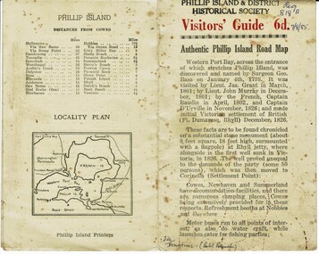 Phillip Island and District Historical Society Inc.
Booklet, Authentic Phillip Island Road Map, Pre 1960
... Authentic Phillip Island Road Map......Road map...Visitors' Guide 6d Authentic Phillip Island Road Map...Authentic Phillip Island Road Map Booklet Phillip Island Printers ...Tourist brochure printed by the Phillip Island Printers pre 1960HistoricalSmall cream coloured brochure with details of accommodation, transport and animals. Inside is a map of the Island with numbered points of interest. There is also a plan of Cowes and drawings of animals.Visitors' Guide 6d Authentic Phillip Island Road Maptourist brochure, road map -
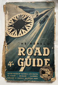 City of Moorabbin Historical Society (Operating the Box Cottage Museum)
Book, Herald Touring Club (Victoria), The Herald road guide, 1950s
... ...road maps...City of Moorabbin Historical Society (Operating the Box Cottage Museum) Joyce Park Jasper Road Ormond melbourne automobile travel road maps herald touring club Map of southeastern Australia, Adelaide to Brisbane, showing roads and distances, with chief detail about Victoria. ...Map of southeastern Australia, Adelaide to Brisbane, showing roads and distances, with chief detail about Victoria. Includes strip maps, itinerary guides, and index. Issued by the Herald Touring Club, with new district and city maps surveyed by the Club.1 atlas (224 p.), 1 folded map : ill., maps ; non-fictionMap of southeastern Australia, Adelaide to Brisbane, showing roads and distances, with chief detail about Victoria. Includes strip maps, itinerary guides, and index. Issued by the Herald Touring Club, with new district and city maps surveyed by the Club.automobile travel, road maps, herald touring club -
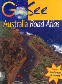 Victorian Aboriginal Corporation for Languages
Book, Valerie Marlborough, Go see Australia road atlas, 2000
... ...road maps...Victorian Aboriginal Corporation for Languages 33 Saxon Street Brunswick melbourne atlases road maps Australian travel Maps, colour photographs Contains state by state maps and details about each state. ...Contains state by state maps and details about each state.Maps, colour photographsatlases, road maps, australian travel -
Victorian Aboriginal Corporation for Languages
Book, Melway Publishing, Melway Greater Melbourne street directory : including Geelong, Phillip Island, Healesville, Kinglake, Gisborne, Lorne, Wallan, Bacchus Marsh, Bellarine &? Mornington Peninsulas, 2005
... ...road maps...Victorian Aboriginal Corporation for Languages 33 Saxon Street Brunswick melbourne maps Victorian street maps street directories road maps maps Street directory including the wider area surrounding Melbourne. ...Street directory including the wider area surrounding Melbourne.mapsmaps, victorian street maps, street directories, road maps -
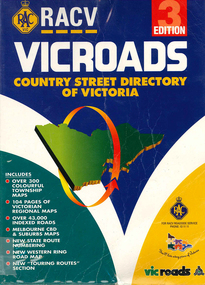 Victorian Aboriginal Corporation for Languages
Book, Royal Automobile Club of Victoria, Vicroads country street directory of Victoria, 1997
... road maps...Victorian Aboriginal Corporation for Languages 33 Saxon Street Brunswick melbourne road maps Maps, colour photographs Country street directory which contains maps, lists, and tourist information. ...Country street directory which contains maps, lists, and tourist information.Maps, colour photographsroad maps -
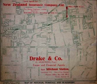 Kew Historical Society Inc
Map - Street Map, R L Jarrett, Map of Mitcham, Tunstall and Blackburn, 1929
... ...road maps...An historically significant advertising map that can be used to ascertain the extent of urban development in 1929 in the areas of Nunawading, Blackburn and Mitcham. real estate agents mitcham tunstall blackburn road maps drake & co new zealand insurance co ltd Map overlaid in red print: "Drake & Co. / (N. ...Tunstall was originally the name of Nunawading Railway Station. Tunstall opened on 4 June 1888 and was renamed on 1 November 1945. An historically significant advertising map that can be used to ascertain the extent of urban development in 1929 in the areas of Nunawading, Blackburn and Mitcham.A map of Mitcham, Tunstall and Blackburn found on the reverse of a real estate subdivision plan published by R. L. Jarrett of Elizabeth Street. This promotional street map is overprinted with the business address of the sponsors and advertising. Map overlaid in red print: "Drake & Co. / (N. Armstrong, Prop.) / Estate and Financial Agents / next Mitcham Station / Established 1914. Open all day Saturday. / Phones: Office, Box Hill 289 J. / Private, Vermont 10."real estate agents, mitcham, tunstall, blackburn, road maps, drake & co, new zealand insurance co ltd -
Canterbury History Group
Document - Frognall - History, Royal Australian Air Force
... Road... Maps...Canterbury History Group 190A Canterbury Road Canterbury melbourne Canterbury Royal Australian Air Force Engineers Cadet Squadron Hicks> Clarence Laycock> Burdett Frognall Mont Albert Road Maps Elgar's Special Survey Photocopy of a 38 page booklet compiled by Royal Australian Air Force Engineers Cadet Squadron , includes maps, house floor plan, photographs and footnotes Document Frognall - History Royal Australian Air Force ...Photocopy of a 38 page booklet compiled by Royal Australian Air Force Engineers Cadet Squadron , includes maps, house floor plan, photographs and footnotescanterbury, royal australian air force engineers cadet squadron, hicks> clarence, laycock> burdett, frognall, mont albert road, maps, elgar's special survey -
Canterbury History Group
Document - The Grange, 1905
... Road... Maps...Duthies Mont Albert Road Maps Gibb> Don MMBW detailed map of "The Grange" 1905. ...MMBW detailed map of "The Grange" 1905. Includes a short history of the house by Don Gibbcanterbury, the grange, fintona junior school, st. duthies, mont albert road, maps, gibb> don -
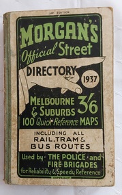 Mont De Lancey
Book, Val. Morgan and Sons Pty. Ltd, Morgan's Official Street Directory 1937, 1937
... ...Road maps...At the back is a free Wall Map showing the main roads of Melbourne and suburbs. The back cover has an advertisement for The Bradshaw and Everett College, 'In the City - yet out of the City at Princes Bridge'. ... Street directories Road maps Melbourne metropolitan area Directories This issue represents the 20th year of publication of Morgan's Official Street Directory so a special coloured wall Map has been included showing the main arterial roads of Melbourne and Suburbs. ...This issue represents the 20th year of publication of Morgan's Official Street Directory so a special coloured wall Map has been included showing the main arterial roads of Melbourne and Suburbs. There are various important lists for reference, e.g Justices of the Peace, Index to Buildings and Chambers and more.A small Morgan's Official Street Directory, 1937. 20th Edition. Melbourne & suburbs, price 3/6. The front cover has green and black lettering on a white background. It has 100 Quick Reference Maps including all Rail, Tram & Bus Routes. Used by . The Police and Fire Brigades for Reliability & Speedy Reference. Copyright. There are may advertised businesses throughout the whole book. At the back is a free Wall Map showing the main roads of Melbourne and suburbs. The back cover has an advertisement for The Bradshaw and Everett College, 'In the City - yet out of the City at Princes Bridge'. It has green fabric tape covering the spine. There is a Forward, Contents, Index to buildings, Chambers, etc in the City, List of Justices of the Peace and more. Pp 328.non-fictionThis issue represents the 20th year of publication of Morgan's Official Street Directory so a special coloured wall Map has been included showing the main arterial roads of Melbourne and Suburbs. There are various important lists for reference, e.g Justices of the Peace, Index to Buildings and Chambers and more.maps, street directories, road maps, melbourne metropolitan area, directories -
Canterbury History Group
Document - 1.1 BACKGROUND
... ...Maling Road...Maps...Boundary of Urban Renewal area Maling Road Maps Camberwell Council 2 Black and white A4 sheets plus 1 map Document 1.1 BACKGROUND ...Urban Renewal Proposal, Refer to Document 1:3 (No. 147 in Catalogue). 2 Black and white A4 sheets plus 1 mapboundary of urban renewal area, maling road, maps, camberwell council -
 Bacchus Marsh & District Historical Society
Map, Lerderderg Gorge Road Goodmans Creek to Gisborne Road
... Lerderderg Gorge Road Bacchus Marsh Maps...map and its purpose has not been established. It was possibly produced to indicate landholders who were impacted by works along the Lerderderg Gorge Road. ...A single page paper map showing various blocks of land along the route of the Lerderderg Gorge Road near Bacchus Marsh from Goodmans Creek to the point where the road joins with Gisborne Road. ...Bacchus Marsh Victoria Maps Lerderderg Gorge Road Bacchus Marsh Maps A single page paper map showing various blocks of land along the route of the Lerderderg Gorge Road near Bacchus Marsh from Goodmans Creek to the point where the road joins with Gisborne Road. ...The date of this map and its purpose has not been established. It was possibly produced to indicate landholders who were impacted by works along the Lerderderg Gorge Road. A single page paper map showing various blocks of land along the route of the Lerderderg Gorge Road near Bacchus Marsh from Goodmans Creek to the point where the road joins with Gisborne Road. The map is pasted into a bound volume containing 76 maps or plans in total. High resolution digital image stored on BMDHS computer network. bacchus marsh victoria maps, lerderderg gorge road bacchus marsh maps -
 Sunshine and District Historical Society Incorporated
Map - Victorian maps of 1856, 1856
... Photocopied reproductions of Travellers road maps of Victoria 1856 showing Lexton or Burnbank LaTrobe collection State Library of Victoria...Victoria Map Photocopied reproductions of Travellers road maps of Victoria 1856 showing Lexton or Burnbank LaTrobe collection State Library of Victoria Victorian maps of 1856 Map Victorian maps of 1856 ...Photocopied reproductions of Travellers road maps of Victoria 1856 showing Lexton or Burnbank LaTrobe collection State Library of Victoriavictoria, map -
Federation University Historical Collection
Map, Robinson's Ballarat Street Map, c1972, 1970s
... It also includes a district road map....It also includes a district road map. Robinson's Ballarat Street Map, c1972 Map Map ...A coloured fold-out street map of Ballarat. It also includes a district road map.ballarat, map, ballarat streets -
 Bendigo Historical Society Inc.
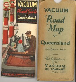
Document - BILL ASHMAN COLLECTION: VACUUM ROAD MAP QUEENSLAND
... BILL ASHMAN COLLECTION: VACUUM ROAD MAP QUEENSLAND...Vacuum Road Map of Queensland with Interstate routes with the compliments of the Vacuum Oil Company Pty Ltd....Document BILL ASHMAN COLLECTION: VACUUM ROAD MAP QUEENSLAND ...Vacuum Road Map of Queensland with Interstate routes with the compliments of the Vacuum Oil Company Pty Ltd.map, queensland, vacuum oil company -
 Bendigo Historical Society Inc.
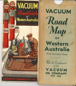
Document - BILL ASHMAN COLLECTION: VACUUM ROAD MAP WESTERN AUSTRALIA
... BILL ASHMAN COLLECTION: VACUUM ROAD MAP WESTERN AUSTRALIA...Vacuum Road Map of Western Australia with overland route with the compliments of the Vacuum Oil Company Pty Ltd....Document BILL ASHMAN COLLECTION: VACUUM ROAD MAP WESTERN AUSTRALIA ...Vacuum Road Map of Western Australia with overland route with the compliments of the Vacuum Oil Company Pty Ltd.map, western australia, vacuum oil company -
 Sunshine and District Historical Society Incorporated
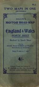
Map - Bacon's Motor Road Map - England and Wales, G.W. Bacon & Co. Ltd
... Bacon's Motor Road Map - England and Wales...A large road map. Key legend depicting colours, lines, land markings, names, places, lattitude and longitude....Map Bacon's Motor Road Map - England and Wales G.W. Bacon & Co. ... -
 Bendigo Military Museum
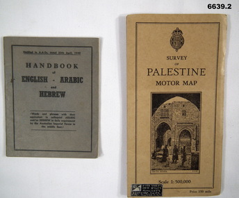
Booklet - HANDBOOK & ROAD MAP, April 1940
... HANDBOOK & ROAD MAP...It is for Australian Imperial Forces in the Middle East. 2. Palestine Road Map. It has cardboard cover and opens out to a road map, scale 1:500,000. ...Booklet HANDBOOK & ROAD MAP ...Sold by Ringarts Bookshop, Haifa1. This is a small pocket book, grey cover, black ink printing. It has words and phrases of colloquial Arabic and/or Hebrew. 32 pages. It is for Australian Imperial Forces in the Middle East. 2. Palestine Road Map. It has cardboard cover and opens out to a road map, scale 1:500,000. It has a drawing of the old section of Jerusalem on front cover.passchendaele barracks trust, 1. nr9430t, 2.9431t, ww2 -
Lakes Entrance Historical Society
Map - Orbost Forest District, D O'Bryan, December 1977
... Roading maps of the forest area of Orbost. Marks highways, all weather roads, dry weather roads, four wheel drive only roads....Lakes Entrance Historical Society 4 Marine Parade Lakes Entrance gippsland Forest Roads and Streets Roading maps of the forest area of Orbost. Marks highways, all weather roads, dry weather roads, four wheel drive only roads. ...Roading maps of the forest area of Orbost. Marks highways, all weather roads, dry weather roads, four wheel drive only roads.forest, roads and streets -
Whitehorse Historical Society Inc.
Map, Site for Wesleyan Church, Nunawading, 1855
... Road...Burwood...Maps...map showing names of landholders. Note on verso: Plan of allotments in the City of Melbourne appropriated to the Wesleyans. Site for Wesleyan Church, Nunawading 1848 (Corner of Burwood and Elgar Roads - S of Burwood, W of Elgar)...Site for Wesleyan Church, Nunawading 1848 (Corner of Burwood and Elgar Roads - S of Burwood, W of Elgar) Churches Wesleyan Church Burwood Burwood Road Burwood Elgar Road Burwood Maps Photocopy of manuscript map showing names of landholders. ...Photocopy of manuscript map showing names of landholders.Photocopy of manuscript map showing names of landholders. Note on verso: Plan of allotments in the City of Melbourne appropriated to the Wesleyans. Site for Wesleyan Church, Nunawading 1848 (Corner of Burwood and Elgar Roads - S of Burwood, W of Elgar)Photocopy of manuscript map showing names of landholders. churches, wesleyan church, burwood, burwood road, burwood, elgar road, burwood, maps -
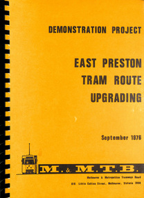 Melbourne Tram Museum
Document - Report, Melbourne & Metropolitan Tramways Board (MMTB), "Demonstration Project - East Preston Tram route upgrading Sept. 1976", Sep. 1976
... ... Road Works... Maps...Melbourne Tram Museum 8 Wallen Road Hawthorn melbourne Trams tramways MMTB Tramways Melbourne Surveys Passengers East Preston Traffic Control Traffic Lights Delays Road Works Maps Report - A4, 170 pages + card coves with plastic sheets black comb bound, titled "Demonstration Project - East Preston Tram route upgrading Sept. 1976" Has a Table of Contents, appendices, photograph, tables and diagrams. ...Report - A4, 170 pages + card coves with plastic sheets black comb bound, titled "Demonstration Project - East Preston Tram route upgrading Sept. 1976" Has a Table of Contents, appendices, photograph, tables and diagrams. Looks at the delays on the East Preston route with methods of overcoming the bunching of trams, installation of kerbs for trams, traffic island, coordinated traffic lights along with Project costs. Notes it is a demonstration project.trams, tramways, mmtb, tramways, melbourne, surveys, passengers, east preston, traffic control, traffic lights, delays, road works, maps