Showing 6705 items matching "road named"
-
 Federation University Historical Collection
Article - Article - Women, Ballarat College of Advanced Education: Women of Note; Dr Kiran Mazumdar-Shaw, (1953 - )
... ...road named...Dr Kiran Mazumdar-Shaw, a most distinguished alumna of the University and a pioneer of the biotechnology industry in India, was honoured by Federation University Australia on Thursday 5 March 2015 with the unveiling of a road named after her at the Mt Helen Campus. ...Dr Kiran Mazumdar-Shaw, a most distinguished alumna of the University and a pioneer of the biotechnology industry in India, was honoured by Federation University Australia on Thursday 5 March 2015 with the unveiling of a road named after her at the Mt Helen Campus. women of note kiran mazumdar-shaw doctor brewer and biotechnologist ballarat college of advanced education honorary doctorate 2004 biotechnology industry in india federation university road named mount helen campus Ballarat College of Advanced Education: Women of Note; Dr Kiran Mazumdar-Shaw, (1953 - ) Article Article - Women ...Kiran Mazumdar-Shaw was the first and only female enrolled as a student in the brewer and biotechnologist course at BCAE In 1974. Her diligence paid off when she managed to top the class, and vital knowledge and understandings acquired during her course have subsequently contributed to other successes. On 13 December 2004 the University of Ballarat recognised Mazumdar-Shaw's pre-eminent contribution to the field of biotechnology when she was presented with an Honorary Doctorate. Dr Kiran Mazumdar-Shaw, a most distinguished alumna of the University and a pioneer of the biotechnology industry in India, was honoured by Federation University Australia on Thursday 5 March 2015 with the unveiling of a road named after her at the Mt Helen Campus. women of note, kiran mazumdar-shaw, doctor, brewer and biotechnologist, ballarat college of advanced education, honorary doctorate, 2004, biotechnology industry in india, federation university, road named, mount helen campus -
 Stawell Historical Society Inc
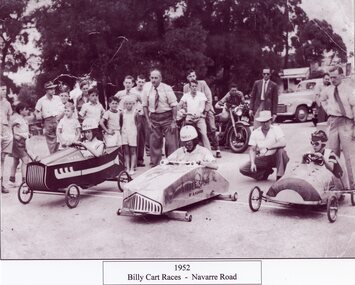
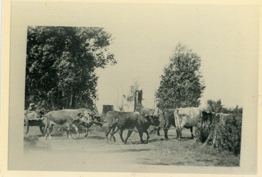
Photograph, Billy Cart Derby on the Navarre Road 1952 -- Named
... Billy Cart Derby on the Navarre Road 1952 -- Named...Stawell Historical Society Inc 46 Longfield St Stawell grampians Billy Cart Derby - Navarre Road 1952 Stawell Billy Cart Derby on the Navarre Road 1952 -- Named Photograph ...Billy Cart Derby - Navarre Road 1952stawell -
Whitehorse Historical Society Inc.
Letter - Correspondence, Letter re Arthur Schwerkolt, 2013
... Regarding changed road names and his parents' places of employment, and their farm next to Schwerkolt Cottage....Whalen and Arthur Schwerkolt regarding changed road names and his parents' places of employment, and their farm next to Schwerkolt Cottage....Whitehorse Historical Society Inc. 2-10 Deep Creek Road Mitcham melbourne Regarding changed road names and his parents' places of employment, and their farm next to Schwerkolt Cottage. ...Meeting between R. Whalen and Arthur Schwerkolt age.Meeting between R. Whalen and Arthur Schwerkolt regarding changed road names and his parents' places of employment, and their farm next to Schwerkolt Cottage.Meeting between R. Whalen and Arthur Schwerkolt age.schwerkolt, arthur, roads and streets, schwerkolt, myra, schwerkolt, ern -
 Ringwood and District Historical Society
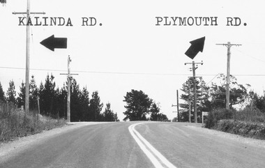
Photograph, Intersection of Kalinda Road and Plymouth Rd. Ringwood 1967
... B&W Photograph with road names and arrows added....B&W Photograph with road names and arrows added. Intersection of Kalinda Road and Plymouth Rd. ...B&W Photograph with road names and arrows added.Catalogue card reads, "Intersection of Kalinda Road and Plymouth Rd. 1967". -
Whitehorse Historical Society Inc.
Article, Fulton Family holds long district line, n.d
... Fulton Road, Blackburn was named after Andrew Fulton....Article on the death of two elderly Fulton brothers, nephews of Andrew Fulton. Fulton Road, Blackburn was named after Andrew Fulton....Article on the death of two elderly Fulton brothers, nephews of Andrew Fulton. Fulton Road, Blackburn was named after Andrew Fulton. Fulton Family holds long district line Article Article ...Article on the death of two elderly Fulton brothers, nephews of Andrew Fulton.Article on the death of two elderly Fulton brothers, nephews of Andrew Fulton. Fulton Road, Blackburn was named after Andrew Fulton.Article on the death of two elderly Fulton brothers, nephews of Andrew Fulton. fulton, john oliver, fulton, william oliver, fulton, andrew, fulton road, blackburn south -
Whitehorse Historical Society Inc.
Article, Love began at Mitcham factory, 2005
... McClare Road Vermont is named after Pat's grandfather who owned a tannery (Photo)...Article about the 70th wedding anniversary of Pat and Gladys McClare who grew up in Mitcham. McClare Road Vermont is named after Pat's grandfather who owned a tannery (Photo)...Whitehorse Historical Society Inc. 2-10 Deep Creek Road Mitcham melbourne McClare Road Vermont is named after Pat's grandfather who owned a tannery (Photo) McClare Pat McClare Gladys McClares Road Vermont Article about the 70th wedding anniversary of Pat and Gladys McClare who grew up in Mitcham. ...Article about the 70th wedding anniversary of Pat and Gladys McClare who grew up in Mitcham.Article about the 70th wedding anniversary of Pat and Gladys McClare who grew up in Mitcham. McClare Road Vermont is named after Pat's grandfather who owned a tannery (Photo)Article about the 70th wedding anniversary of Pat and Gladys McClare who grew up in Mitcham. mcclare, pat, mcclare, gladys, mcclares road vermont -
Whitehorse Historical Society Inc.
Article, Carefree days last for decades, 2005
... McClares Road Vermont is named after Pat's grandfather who owned a tannery (photo)...Article about the 70th wedding anniversary of Pat and Gladys McClare who grew up in Mitcham. McClares Road Vermont is named after Pat's grandfather who owned a tannery (photo)...Whitehorse Historical Society Inc. 2-10 Deep Creek Road Mitcham melbourne McClares Road Vermont is named after Pat's grandfather who owned a tannery (photo) McClare Pat McClare Gladys McClares Road Vermont Article about the 70th wedding anniversary of Pat and Gladys McClare who grew up in Mitcham. ...Article about the 70th wedding anniversary of Pat and Gladys McClare who grew up in Mitcham.Article about the 70th wedding anniversary of Pat and Gladys McClare who grew up in Mitcham. McClares Road Vermont is named after Pat's grandfather who owned a tannery (photo)Article about the 70th wedding anniversary of Pat and Gladys McClare who grew up in Mitcham.mcclare, pat, mcclare, gladys, mcclares road vermont -
 Ringwood and District Historical Society
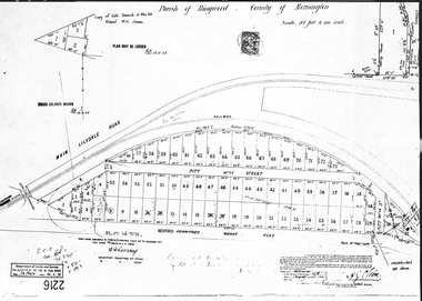
Document, Map - Parish of Ringwood, County of Mornington (Plan of Subdivision, Part of Crown Portion 11) - 1888
... Map accuracy certification date - 27th August 1888. Road name amended from Ferntree Gully Road to Bedford Road 8.4.1930. ...Ringwood and District Historical Society 125A Warrandyte Road Ringwood North melbourne Map accuracy certification date - 27th August 1888. Road name amended from Ferntree Gully Road to Bedford Road 8.4.1930. ...A4 photocopy showing numbered allotments abutting the railway line, fronting Pitt Street, and Bedford Road (previously Ferntree Gully Road)Map accuracy certification date - 27th August 1888. Road name amended from Ferntree Gully Road to Bedford Road 8.4.1930. Later re-subdivision notations included on 26.2.1946. -
Whitehorse Historical Society Inc.
Map, This is Vermont, 1895-1920?
... Hand-drawn map of Vermont from Springvale Road to Heatherdale Road, showing the names of owners of houses, main roads and streets, shops and schools....'Now you have seen it, tell your friends' - hand-drawn map of Vermont from Springvale Road to Heatherdale Road, showing the names of owners of houses, main roads and streets, shops and schools....Whitehorse Historical Society Inc. 2-10 Deep Creek Road Mitcham melbourne Hand-drawn map of Vermont from Springvale Road to Heatherdale Road, showing the names of owners of houses, main roads and streets, shops and schools. ...'Now you have seen it, tell your friends''Now you have seen it, tell your friends' - hand-drawn map of Vermont from Springvale Road to Heatherdale Road, showing the names of owners of houses, main roads and streets, shops and schools.'Now you have seen it, tell your friends' vermont south, vermont, roads and streets -
 Peterborough History Group
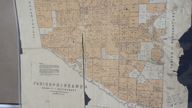
Map - Map of the Parish of Nirranda, Parish of Nirranda
... Map of the Parish including roads, names of landowners, location of schools etc in 1939...Peterborough History Group Peterborough great-ocean-road Map of the Parish including roads, names of landowners, location of schools etc in 1939 nirranda Maps Parish map A3 size map of the Parish of Nirranda in 1939 Parish of Nirranda Map Map of the Parish of Nirranda ...Map of the Parish including roads, names of landowners, location of schools etc in 1939A3 size map of the Parish of Nirranda in 1939nirranda, maps, parish map -
 Whitehorse Historical Society Inc.
Administrative record - Council Minutes, Lango Lane, Mitcham, 20/11/2006
... The lane behind 699 Whitehorse Road, Mitcham needed a name and the Wurundjeri tribe was consulted to provide one, Their choice was Lango Lane meaning "edge"....The lane behind 699 Whitehorse Road, Mitcham needed a name and the Wurundjeri tribe was consulted to provide one and their choice was Lango Lane meaning "edge"....Whitehorse Historical Society Inc. 2-10 Deep Creek Road Mitcham melbourne The lane behind 699 Whitehorse Road, Mitcham needed a name and the Wurundjeri tribe was consulted to provide one, Their choice was Lango Lane meaning "edge". ...The lane behind 699 Whitehorse Road, Mitcham needed a name and the Wurundjeri tribe was consulted to provide one, Their choice was Lango Lane meaning "edge".The lane behind 699 Whitehorse Road, Mitcham needed a name and the Wurundjeri tribe was consulted to provide one and their choice was Lango Lane meaning "edge".lango lane, whitehorse road mitcham no 699, wurundjeri, lanes -
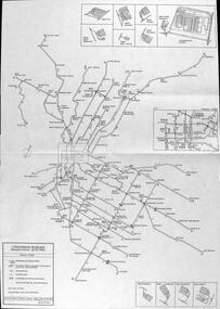
 Melbourne Tram Museum
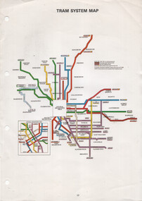
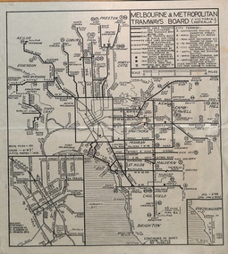
Map, The Met, "Tram System Map", c1990
... Tram system map published by The Met to show the various Melbourne tram routes, route numbers, principal road names, suburbs and tram routes within the Central Business District....Melbourne Tram Museum 8 Wallen Road Hawthorn melbourne Tram system map published by The Met to show the various Melbourne tram routes, route numbers, principal road names, suburbs and tram routes within the Central Business District. ...Tram system map published by The Met to show the various Melbourne tram routes, route numbers, principal road names, suburbs and tram routes within the Central Business District.Provides information about Melbourne tram routes c1990Printed A4 full colour sheet with four punch holes on left hand side.tramways, melbourne, the met, map, tram routes, routes -
 Melbourne Tram Museum
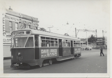
Photograph - Black & White Photograph/s, Chris Phillips, Feb. 1969
... ARE Tour ex South Melbourne depot. Road name to be advised. Printed on Kodak Paper....ARE Tour ex South Melbourne depot. Road name to be advised. Printed on Kodak Paper. ...Black and white photograph of PCC 980 at Caulfield Station area, during a special tram tour, 9/2/1969. Photo by Chris Phillips. Glen Valley Tea advert in background. Has a Dave Price advertisement on the side of the tram. ARE Tour ex South Melbourne depot. Road name to be advised. Printed on Kodak Paper.In red ink "PCC 980 Caulfield Stn 9/2/69"trams, tramways, mmtb, special trams, caulfield, tram 980, pcc class -
 Dandenong & District Historical Society
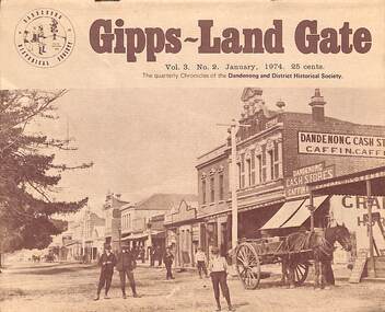
Journal, Dandenong & District Historical Society, Gipps-Land Gate Vol.3 No.2, 1974
... Keeping Posted How Postal Development Grew With Dandenong Road Names - Some Probable Origins The Clock in Dandenong Town Hall Tower A Link With Early History Broken Red Gum Medication Local Government 1865-1866 Roads Board Style ...Keeping Posted How Postal Development Grew With Dandenong Road Names - Some Probable Origins The Clock in Dandenong Town Hall Tower A Link With Early History Broken Red Gum Medication Local Government 1865-1866 Roads Board Style Gipps-Land Gate Vol.3 No.2 Journal Dandenong & District Historical Society ...An interesting group of Early Dandenong Personalities, Places and EventsA5 size publication of the Gipps-Land Gate, January 1974. 16 pages, featuring an old picture of Dandenong on the cover. Keeping Posted How Postal Development Grew With Dandenong Road Names - Some Probable Origins The Clock in Dandenong Town Hall Tower A Link With Early History Broken Red Gum Medication Local Government 1865-1866 Roads Board Style An interesting group of Early Dandenong Personalities, Places and Eventshotel history, early education in dandenong, interesting milestones, family histories -
 Southern Sherbrooke Historical Society Inc.
Photograph, Corner Glenfern & Lysterfield Rds, Lysterfield
... A sign indicates the road names. Photo is copied from Sherbrooke Foothills Historical Society's page on Facebook....A sign indicates the road names. Photo is copied from Sherbrooke Foothills Historical Society's page on Facebook. ...Photo taken in December 1967. Black and white photo showing the intersection of Glenfern and Lysterfield Roads in December 1967. Photo is taken from north east corner of intersection and shows hills, hedges and shedding or buildings in background and two cars heading south along Lysterfield Road. A sign indicates the road names. Photo is copied from Sherbrooke Foothills Historical Society's page on Facebook. -
Lakes Entrance Historical Society
Map - Kalimna Allotments
... Photocopies of roads and land owners names Lighthouse Reserve...Lakes Entrance Historical Society 4 Marine Parade Lakes Entrance gippsland Land Development land owners Roads and Streets Photocopies of roads and land owners names Lighthouse Reserve Map Kalimna Allotments ...Photocopies of roads and land owners names Lighthouse Reserveland development, land owners, roads and streets -
 Melbourne Tram Museum
Map, P. Sohns, "Strassenbahn Melbourne Gleisplan", 10-9-1992
... Shows the track layout, crossovers, depots, route numbers, railway/tramway level crossings, terminus details, road names and a CBD insert. Prepared by P Sohns of Germany - dated 10-9-1992....Shows the track layout, crossovers, depots, route numbers, railway/tramway level crossings, terminus details, road names and a CBD insert. Prepared by P Sohns of Germany - dated 10-9-1992. ...Map of Melbourne's tramway system prepared for a German audience - as at 28-5-1992. Shows the track layout, crossovers, depots, route numbers, railway/tramway level crossings, terminus details, road names and a CBD insert. Prepared by P Sohns of Germany - dated 10-9-1992.Yields information Melbourne tramways and routes in 1992.Map - A2 sheet folded to A4.tramways, maps, melbourne, germany -
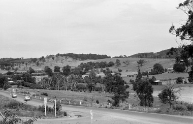
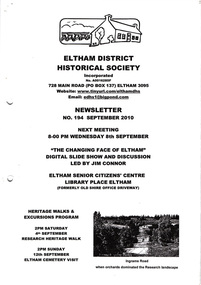 Eltham District Historical Society Inc
Newsletter, Newsletter, No. 194 September 2010
... Contents: • Next meeting, Slide Show and Discussion led by Jim Connor: The Changing Face of Eltham • September Meeting • Research Heritage Walk • Eltham Cemetery Visit • Distinguished Life Members by Jim Connor • Jock Read’s Early History • Local Road Names; The North-South Roads • More News ...Eltham District Historical Society Inc 728 Main Rd Eltham melbourne Contents: • Next meeting, Slide Show and Discussion led by Jim Connor: The Changing Face of Eltham • September Meeting • Research Heritage Walk • Eltham Cemetery Visit • Distinguished Life Members by Jim Connor • Jock Read’s Early History • Local Road Names; The North-South Roads • More News The Shire of Eltham Historical Society was formed in October 1967. ...Contents: • Next meeting, Slide Show and Discussion led by Jim Connor: The Changing Face of Eltham • September Meeting • Research Heritage Walk • Eltham Cemetery Visit • Distinguished Life Members by Jim Connor • Jock Read’s Early History • Local Road Names; The North-South Roads • More News The Shire of Eltham Historical Society was formed in October 1967. The first newsletter of the Society was issued May 1978 and has been published continuously ever since on a bi-monthly basis. With the cessation of the Shire of Eltham in late 1994, the Society's name was revised to Eltham District Historical Society and this name first appeared with issue No. 103, July 1995. The collection of the Society's newsletters provides a valuable resource on the history of the Society's activities, office bearers and committee members, guest speakers and subjects of historical interest pertinent to the former Shire of Eltham and the Eltham District.A4 photocopied newsletter distributed to membersnewsletter, eltham district historical society, shire of eltham historical society -
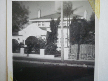 Glen Eira Historical Society
Photograph - St. Georges Road, 36, Elsternwick
... Georges Road, Elsternwick, named Aloha....Georges Road, Elsternwick, named Aloha. Photographs House Names St. ...A black and white photograph, undated, of the house at 36 St. Georges Road, Elsternwick, named Aloha.photographs, house names, st. georges road, aloha, elsternwick, houses -
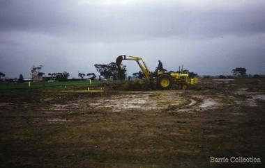 Melton City Libraries
Photograph, Building a new school, 1974
... In 1975, Melton High School opened its doors. Coburn Road named after Coburns, early settlers family and George Coburn Councillor and 1935 Shire President...In 1975, Melton High School opened its doors. Coburn Road named after Coburns, early settlers family and George Coburn Councillor and 1935 Shire President Education Earth works undertaken for the development of Melton High School, Coburns Road, Melton West Building a new school Photograph Barrie Collection ...There were no high schools in the area pre 1975, and students from Melton, Melton South and Toolern Vale State Schools went by bus to Bacchus Marsh High School. In 1975, Melton High School opened its doors. Coburn Road named after Coburns, early settlers family and George Coburn Councillor and 1935 Shire PresidentEarth works undertaken for the development of Melton High School, Coburns Road, Melton Westeducation -
 Warrnambool and District Historical Society Inc.
Financial record - Ledger, Warrnambool Shire Council 1899-1918, Circa 1900
... It covers such topics as repairs to bridges, purchasing of equipment, complaints, applications for roads. Names of places and structures include Dennington Bridge, Cassidy’s Bridge, Warrumyea Bridge, Yangery, Purnim. ...It covers such topics as repairs to bridges, purchasing of equipment, complaints, applications for roads. Names of places and structures include Dennington Bridge, Cassidy’s Bridge, Warrumyea Bridge, Yangery, Purnim. ...Provides a collection of letters to the President and Councillors of the Shire of Warrnambool from J. M. Crawley. The period covered is 1900 to 1918. It covers such topics as repairs to bridges, purchasing of equipment, complaints, applications for roads. Names of places and structures include Dennington Bridge, Cassidy’s Bridge, Warrumyea Bridge, Yangery, Purnim. Loose within the book is a letter from a W,M(H?) Clarke of Garvoc. The letters contained in this ledger provide information on a large range of works which were carried out in the Shire in the early 1900’sDark olive green fabric cover with tan spine and cornersMinute Book in gold lettering on red background on spine.warrnambool shire council 1899-1918, crawley j w crawley, warrnambool shire offices, warrnambool -
 Melbourne Tram Museum
Map - MMTB Map, John Gillham, 2/1948
... Map prepared in Feb. 1948 by John Charles Gillham (see reference) showing Melbourne's tramways, some of the horse tram lines, proposed lines, cable tramways pending conversion and depots with road names, routes and locations of City termini. ...Map prepared in Feb. 1948 by John Charles Gillham (see reference) showing Melbourne's tramways, some of the horse tram lines, proposed lines, cable tramways pending conversion and depots with road names, routes and locations of City termini. ...Map prepared in Feb. 1948 by John Charles Gillham (see reference) showing Melbourne's tramways, some of the horse tram lines, proposed lines, cable tramways pending conversion and depots with road names, routes and locations of City termini. Has an inset for the City area and Sandrinham VR line. Possibly prepared for Modern Tramway magazine. Has some minor errors such as an addition "wiggle" in the aerodrome line.Yields information about Melbourne tramways in 1948 and has a close association with John Gillham, a well known UK based draftsman and tramway enthusiast.Printed reproduction sheet folded in the centre.maps, melbourne, tramways, mmtb, vr, horse trams -
Whitehorse Historical Society Inc.
Letter - Correspondence, Janice Rooks, 2016
... A letter from Janice Rooks describing how Rooks and McClares Roads, Vermont were named after her Great-grandparents....A letter from Janice Rooks describing how Rooks and McClares Roads, Vermont were named after her Great-grandparents. ...A letter from Janice Rooks describing how Rooks and McClares Roads, Vermont were named after her Great-grandparents.A letter from Janice Rooks describing how Rooks and McClares Roads, Vermont were named after her Great-grandparents.A letter from Janice Rooks describing how Rooks and McClares Roads, Vermont were named after her Great-grandparents.rooks, janice, vermont state school no 1022, rooks, charles mayor, mcclare, mcclares road, vermont, charles rooks reserve, rooks road, vermont -
 Bendigo Historical Society Inc.
Document - Hustlers, Sheepshead and Deborah lines of reef
... The park opposite the Goldmines Hotel in Marong Road, is named in his honour. ...The park opposite the Goldmines Hotel in Marong Road, is named in his honour. Bendigo gold mining Deborah line of reef Sheepshead line of reef Hustlers line of reef Royal Hustlers Reserve mine Hustlers Hill group of mines Great Extended Hustlers Hustlers Reef No. 1 Lightning Hill line Old Comet Collman and Tacchi Lansell's Comet North Deborah Central Deborah Dhrrpdhrsf linr og trrg New Red White and Blue Consolidated mine Big Blue Lansell's Bendigo Battery North Red White and Blue mine Albert Richardson Collection Five page document, hand written by Albert Richardson on lined foolscap and edited with cross-outs and insertions, . ...Albert Richardson was a mining historian who wrote widely on the mines of the Bendigo Goldfield. The park opposite the Goldmines Hotel in Marong Road, is named in his honour. Five page document, hand written by Albert Richardson on lined foolscap and edited with cross-outs and insertions, . The mines along the Hustlers line of reef and the Sheepshead line of reef are described. Mines listed on Hustlers line of reef: Fortuna Hustlers (1888 - 1913), shaft 2,240 feet at rear of Buckell and Jeffrey's offices; Royal Hustlers Reserve No. 2 - two shafts 'City" 860 feet, now covered by R.S.L. building Pall Mall, steel poppet legs 60 ft high and 'Park Shaft" at rear of Camp Hill School, 1,775 feet, steel poppet legs 60 feet high; Hustlers Hill Group first worked by Jonathan Harris in 1853 and bounded by Valentine, Anderson and Ironbark Creek to the north and Milroy Street to the east, one of first areas worked for quartz reefing. It with Garden Gully line west and Victoria Hill Ironbark, formed by far the richest cross section of the Bendigo Goldfield. Great Extended Hustlers (1865-1921) close to intersection of Anderson Street and Hustlers Road, mullock heap against road and shored up around shaft, steel poppet legs now at Wattle Gully mine, Chewton, large winding machine, air compressor south of shaft and 36 head crushing battery. Hustlers Reef (Old Hustlers) and Hustlers Reef No. 1, two shafts, main 2,210 feet, about 220 yards east of Moran Street and against Fenton Street. , No. 1 shaft 1,140 feet and about 155 yards east of Moran Street. Lansell's Comet, Lightining Hill line, 2.100 feet, on Comet Hill approx 70 yards west of Holmes Road, near Comet Creek, steel poppet legs. United Hustlers and Redan (1876-1918), main Redan, 1,830 feet about 155 yards west of Sandhurst Roead, in line with Comet Hill State School, this hill known as Redan Hill. North, or New Hustlers, once known as Agnew Hustlers, wooden poppet legs, south side, Kneebone Street, Eaglehawk. Derby line, Johnson's No. 3, South Johnson's (east shaft of Collman and Tacchi) 439 feet on west wide of Woods Street, south of Wetherall Street. Paddy's Gully Line, south to north, some shafts - Lansell's 'Sandhurst" ('Needle") Eaglehawk Road shaft 2,425 feet, about 50 yards east of Needle Loops, a brick square sided chimney with Cleopatra Needle top. British American, 789 feet, just south of Holdsworth Road. Collman and Tacchi, main shaft 2,588 feet, 60 yards west of Eaglehawk Road, California Gully. Deborah Line of Reef, The Deborah (1932-1954) shaft 2.017 feet, west of Adams Road and south of Abel Street, Quarry Hill. North Deborah (1937 - 1954) shaft 1,151 feet, Breen Street, Quarry Hill, steel poppet legs. Central Deborah (1939-1954) shaft 1,347 feet Sheepshead line of reef, Lansell's South Red, White and Blue, shaft 2,124 feet, north east of Bellevue Road and 220 yards east of Adams Road. The New Red, White and Blue Consolidated (Big Blue) main shaft 2,416 feet. Lansell's Bendigo Battery 105 head, north of 'Big Blue" on his freehold lease, commenced crushing on 24th February 1895. After closing was erected as the Showground's Industrial Hall, July 1926. North Red, White and Blue, burnt down February 1926, new company 1934, closed 1938. Document is part of the Albert Richardson Collection of Bendigo mining history. bendigo, gold mining, deborah line of reef, sheepshead line of reef, hustlers line of reef, royal hustlers reserve mine, hustlers hill group of mines, great extended hustlers, hustlers reef no. 1, lightning hill line, old comet, collman and tacchi, lansell's comet, north deborah, central deborah, dhrrpdhrsf linr og trrg, new red, white and blue consolidated mine, big blue, lansell's bendigo battery, north red, white and blue mine, albert richardson collection -
 Bendigo Historical Society Inc.
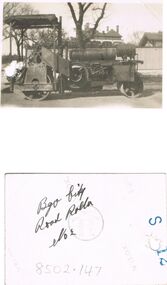
Photograph - BILL ASHMAN COLLECTION: BENDIGO CITY ROAD ROLLER
... Small black and white photo of Bendigo City Road Roller No 2. Name written on the back....History House 11 Mackenzie Street Bendigo goldfields SCIENCES Instruments - general scalebuoy Bill Ashman Collection - Correspondence Bendigo City Road Roller No 2 Small black and white photo of Bendigo City Road Roller No 2. Name written on the back. Photograph BILL ASHMAN COLLECTION: BENDIGO CITY ROAD ROLLER ...Small black and white photo of Bendigo City Road Roller No 2. Name written on the back.sciences, instruments - general, scalebuoy, bill ashman collection - correspondence, bendigo city road roller no 2 -
 Bendigo Historical Society Inc.
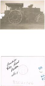
Photograph - BILL ASHMAN COLLECTION: BENDIGO CITY ROAD ROLLER
... Small dull black photo of the Bendigo City Road Roller No 1. Name written on the back....History House 11 Mackenzie Street Bendigo goldfields SCIENCES Instruments - general scalebuoy Bill Ashman Collection - Correspondence Bendigo City Road Roller No 1 Small dull black photo of the Bendigo City Road Roller No 1. Name written on the back. Photograph BILL ASHMAN COLLECTION: BENDIGO CITY ROAD ROLLER ...Small dull black photo of the Bendigo City Road Roller No 1. Name written on the back.sciences, instruments - general, scalebuoy, bill ashman collection - correspondence, bendigo city road roller no 1 -
 Kew Historical Society Inc
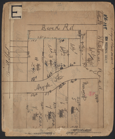
Plan - Subdivision Plan, Lodged Plan No.6518, 1920-1940
... Reconciling this hand-drawn subdivision plan with a modern map of the area is initially a challenge due to a change of street names. Argyle Road in the centre of the subdivision was to be renamed Deepdene Road, and the street named Deepdene Road on the plan was to become Deepdene Place. ...Argyle Road in the centre of the subdivision was to be renamed Deepdene Road, and the street named Deepdene Road on the plan was to become Deepdene Place. ...The Kew Historical Society collection includes almost 100 subdivision plans pertaining to suburbs of the City of Melbourne. Most of these are of Kew, Kew East or Studley Park, although a smaller number are plans of Camberwell, Deepdene, Balwyn and Hawthorn. It is believed that the majority of the plans were gifted to the Society by persons connected with the real estate firm - J. R. Mathers and McMillan, 136 Cotham Road, Kew. The Plans in the collection are rarely in pristine form, being working plans on which the agent would write notes and record lots sold and the prices of these. The subdivision plans are historically significant examples of the growth of urban Melbourne from the beginning of the 20th Century up until the 1980s. A number of the plans are double-sided and often include a photograph on the reverse. Reconciling this hand-drawn subdivision plan with a modern map of the area is initially a challenge due to a change of street names. Argyle Road in the centre of the subdivision was to be renamed Deepdene Road, and the street named Deepdene Road on the plan was to become Deepdene Place. Of interest is the nursery on the corner of Argyle and Whitehorse Roads. During this period there were a number of nurseries servicing the Kew and Balwyn areas. The subdivision was essentially of the land formerly occupied by the house 'Deepdene'.subdivision plans - balwyn, deepdene, whitehorse road -- deepdene (vic.), deepdene road -- deepdene (vic.), burke road -- deepdene (vic.) -
 Federation University Historical Collection
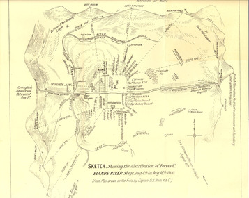
Plan, Sketch of Elands River Siege, 1900
... Map details surrounding hills, roads, rivers, and names all soldiers involved in siege. ...Map details surrounding hills, roads, rivers, and names all soldiers involved in siege. ...Plan based on the field notes of Captain David John Ham, V.B.C. For article written by Ham on the event, see http://trove.nla.gov.au/ndp/del/article/9542500 For obituary of Ham, see http://trove.nla.gov.au/ndp/del/article/11023251Sketched paper map of forces' distribution at the Elands River siege. Map details surrounding hills, roads, rivers, and names all soldiers involved in siege. boer war, map, sketch, victorian's bushmen contingent, hocking, fowles, methuens, david john ham -
 Mt Dandenong & District Historical Society Inc.
Photograph, Sim Kent's Bullocks at Coonara Springs, 1911, 1911
... 1911 Sim Kent’s bullock team turning into their home paddock in Mernda Road at Coonara Springs after which the road is now named. ...Farndons Community Hall 42 Falls Road Mt Dandenong yarra-valley-and-the-dandenong-ranges Sim Kent bullocks Coonara Springs mernda road Coonara Road Olinda 1911 Sim Kent’s bullock team turning into their home paddock in Mernda Road at Coonara Springs after which the road is now named. Photograph showing Sim Kent's bullocks at Coonara Springs in 1911. ...Photograph showing Sim Kent's bullocks at Coonara Springs in 1911. The descriptive text on the reverse of this photograph was hand written by John Lundy-Clarke. 1911 Sim Kent’s bullock team turning into their home paddock in Mernda Road at Coonara Springs after which the road is now named. sim kent, bullocks, coonara springs, mernda road, coonara road, olinda -
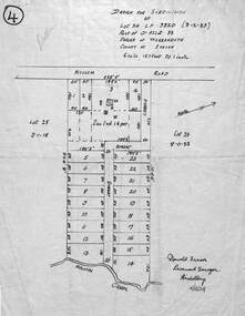 Ringwood and District Historical Society
Map - Design for Subdivision, Part of Crown Allotment 33, Parish of Warrandyte, County of Evelyn, Lot 24 Mullum Mullum Road, Ringwood, Victoria
... Diagram showing layout and dimensions of 23 allotments on Mullum Mullum Road and un-named streets, later The Centreway and Wattle Avenue, Ringwood. ...Ringwood and District Historical Society 125A Warrandyte Road Ringwood North melbourne Donald Fraser, Licensed Surveyor, Heidelberg - 11/12/1924 Diagram showing layout and dimensions of 23 allotments on Mullum Mullum Road and un-named streets, later The Centreway and Wattle Avenue, Ringwood. ...Diagram showing layout and dimensions of 23 allotments on Mullum Mullum Road and un-named streets, later The Centreway and Wattle Avenue, Ringwood. LP3820 (9-2-1929).Donald Fraser, Licensed Surveyor, Heidelberg - 11/12/1924