Showing 129038 items matching "road-making"
-
 Emerald Museum & Nobelius Heritage Park
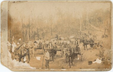
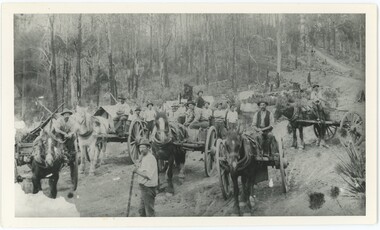
Photograph, Mr O'Connor, Making the Road to Clematis, c. 1920
... Making the Road to Clematis...In late 1919, the Country Roads Board approved an amendment of the Belgrave-Emerald Road between Gembrook Road (likely now Old Gembrook Road) in Emerald and Paradise (now Clematis) Station. ...A sepia photograph on card backing depicting a road construction project. The workers are relying on horses and manual labour to build a road amongst trees and hills. ...Rear: "Mr O'Connor / 12 / date / Clematis / Making the Road to Clematis / 1920?"...Ogilvy Road, Emerald, Victoria, Australia...The rear has some handwritten text, with some illegible. Making the Road to Clematis Photograph Mr O'Connor ...In late 1919, the Country Roads Board approved an amendment of the Belgrave-Emerald Road between Gembrook Road (likely now Old Gembrook Road) in Emerald and Paradise (now Clematis) Station. This image shows part of those works, where they intersected with Ogilvy Road. Public works projects such as road constructions were popular in the immediate aftermath of the First World War, when many men returned home without work and were eager to earn a living by participating in government projects.This image represents an infrastructure project from the 1920s that helped to build the Emerald of today. It displays the tools and technology available for public works projects in the early 20th century, and the manner in which road construction occurred.A sepia photograph on card backing depicting a road construction project. The workers are relying on horses and manual labour to build a road amongst trees and hills. The lower-left corner of the photograph is damaged and faded, with some damage and the photo peeling away from the backing along the left side as a whole. The rear has some handwritten text, with some illegible.Rear: "Mr O'Connor / 12 / date / Clematis / Making the Road to Clematis / 1920?"emerald, clematis, 1920s, transport -
 Kiewa Valley Historical Society
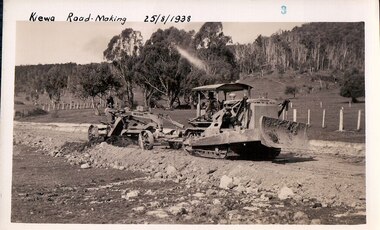
Black and White photograph of Road Making Machinery, Kiewa Road Making 25/08/1938 No. 2, 25/08/1938
... Kiewa Road Making 25/08/1938 No. 2...Construction of the main road from South Tawonga to the Bogong High Plains, to provide access to the construction sites for the new Kiewa Hydro Electric Scheme, was commenced early in 1938, the work being undertaken on behalf of the commission by the Country Roads Board. ...A black and white photograph of road making near Mt. Beauty in 1938. Mount Beauty hills can be seen in the background with cleared land for grazing in the fore ground....Hand printed in black ink at the top of the photograph is 'Kiewa Road Making 25/8/1938'. On the right hand corner has been printed the number 2. ...Kiewa Road Making 25/08/1938 No. 2 Black and White photograph of Road Making Machinery Possibly taken by the State Electricity Commission ...Construction of the main road from South Tawonga to the Bogong High Plains, to provide access to the construction sites for the new Kiewa Hydro Electric Scheme, was commenced early in 1938, the work being undertaken on behalf of the commission by the Country Roads Board. For the construction work, the Commission purchased three Caterpillar - model R07 - diesel crawler tractors equipped with Kay Brunerei (Brunner) hydraulically operated trailbuilders (angle dozers). This acquisition resulted from a visit to the United States of America in May, 1937 by the Construction Engineer ( Mr. C.H. Kernot) and Assistant Civil Engineer ( Mr. J.F. Douglas) where they saw this relatively new type of equipment in use. With the co-operation of the CRB, the Commission demonstrated the operation of these machines at Fishermen's Bend on 6th April, 1938. They were then sent to Kiewa where they commenced operation towards the end of the month. From South Tawonga, the route let immediately across the Western Branch of the Kiewa River necessitating the construction of a bridge 100 feet long. By the end of 1939, the excavation had been 'opened up' for a distance of 19 1/2 miles (approx. 31 km.) and of this length, 10 miles (approx. 16 km.) had been surfaced. (see KVHS 0328)The purchase of this type of mechanical equipment in road making was a huge investment, as prior to this most of the work would have been done manually with the use of picks and shovels. Not only were many months of hard manual labour saved, but a very significant amount of time in providing access to the proposed work sites for the new Kiewa Hydro Scheme. This photo is an excellent reminder of how primitive the early machinery was compared to the present but also represents the forward thinking of the State Electricity Commissions engineers in purchasing such innovative equipment.A black and white photograph of road making near Mt. Beauty in 1938. Mount Beauty hills can be seen in the background with cleared land for grazing in the fore ground.Hand printed in black ink at the top of the photograph is 'Kiewa Road Making 25/8/1938'. On the right hand corner has been printed the number 2. It has been printed on gloss Velox paper.road making, state electricity commission, caterpillar tractor, kiewa, secv -
 Kiewa Valley Historical Society
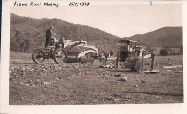
Black and White photograph of Road Making Machinery, Kiewa Road Making 25/8/1938(No. 3 in a series of 8), 25/08/1938
... Kiewa Road Making 25/8/1938(No. 3 in a series of 8)...Construction of the main road from South Tawonga to the Bogong High Plains, to provide access to the construction sites for the new Kiewa Hydro Electric Scheme, was commenced early in 1938, the work being undertaken on behalf of the Commission by the Country Roads Board. ...A black and white photograph of a Caterpillar diesel crawler tractor and a hydraulically operated trailbuilder (angle dozer) making a road in the Mt. Beauty area....Hand written in black ink in the top left hand corner are the words "Kiewa Road Making 25/8/1938". On the upper right hand of the photograph has been stamped the number 3. ...A black and white photograph of a Caterpillar diesel crawler tractor and a hydraulically operated trailbuilder (angle dozer) making a road in the Mt. Beauty area. Kiewa Road Making 25/8/1938(No. 3 in a series of 8) Black and White photograph of Road Making Machinery possibly a professional photographer for the State Electricity Commission of Victoria possibly the State Electricity Commission of Victoria ...Construction of the main road from South Tawonga to the Bogong High Plains, to provide access to the construction sites for the new Kiewa Hydro Electric Scheme, was commenced early in 1938, the work being undertaken on behalf of the Commission by the Country Roads Board. For the construction work, the Commission purchased three Caterpillar - model R07 - diesel crawler tractors equipped with Kay Brunerei (Brunner) hydraulically operated trail builders (angle dozers)). This acquisition resulted from a visit to the United States of America in May, 1937 by the Construction Engineer ( Mr. C.H. Kernot) and Assistant Civil Engineer (Mr. J.F. Douglas) where they saw this relatively new type of equipment in use. With the co-operation of the CRB, the Commission demonstrated the operation of these machines at Fishermen's Bend on 6th April, 1938. They were then sent to Kiewa where they commenced operation towards the end of the month. From South Tawonga, the route led immediately across the Western Branch of the Kiewa River necessitating the construction of a bridge 100 feet long. By the end of 1939,the excavation had been 'opened up' for a distance of 19 1/2 miles (approx. 31 km.) and of this length, 10 miles (approx. 16 km) had been surfaced.The purchase and use of this type of mechanical equipment in road making was a huge investment, as prior to this most of the work would have been done manually with the use of picks and shovels. Not only were many months of hard manual labour saved, but a very significant amount of time in providing access to the proposed work sites for the new Kiewa Hydro Scheme. This photo is an excellent reminder of how primitive the early machinery was compared to the present but also represents the forward thinking of the State Electricity Commission's Engineers in purchasing such new and innovative equipment.A black and white photograph of a Caterpillar diesel crawler tractor and a hydraulically operated trailbuilder (angle dozer) making a road in the Mt. Beauty area.Hand written in black ink in the top left hand corner are the words "Kiewa Road Making 25/8/1938". On the upper right hand of the photograph has been stamped the number 3. On the back is stamped the word 'Velox' severaly times, which is the make of the photograhic paper. roadmaking, caterpillar tractor, kiewa, state electricity commission -
 Kiewa Valley Historical Society
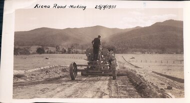
Black and White photograph of Road Making Machinery, Kiewa Road Making, 25/08/1938
... Kiewa Road Making...Construction of the main road from South Tawonga to the Bogong High Plains, to provide access to the construction sites for the new Kiewa Hydro Electric Scheme, was commenced early in 1938, the work being undertaken on behalf of the Commission by the Country Roads Board. ...A black and white photograph showing the type of machinery used for road making in the 1930's. It shows a grader being towed by a caterpillar tractor....On the top left hand corner of the photograph , hand written in black ink is the words 'Kiewa Road Making 25/8/1938'. On the right hand side of the photo has been stamped in blue the Number 1. ...Kiewa Road Making Black and White photograph of Road Making Machinery Possibly taken by the State Electricity Commission ...Construction of the main road from South Tawonga to the Bogong High Plains, to provide access to the construction sites for the new Kiewa Hydro Electric Scheme, was commenced early in 1938, the work being undertaken on behalf of the Commission by the Country Roads Board. For the construction work, the Commission purchased three Caterpillar - model R07 - diesel crawler tractors equipped with Kay Brunerei (Brunner) hydraulically operated trailbuilders (angle dozers). This acquisition resulted from a visit to the United States of America in May, 1937 by the Construction Engineer ( Mr. C.H. Kernot) and Assistant Civil Engineer (Mr. J.F. Douglas) where they saw this relatively new type of equipment in use. With the co-operation of the CRB, the Commission demonstrated the operation of these machines at Fishermen's Bend on 6th April, 1938. They were then sent to Kiewa where they commenced operation towards the end of the month. From South Tawonga, the route led immediately across the Western Branch of the Kiewa River necessitating the construction of a bridge 100 feet long. By the end of 1939, the excavation had been 'opened up' for a distance of 19 1/2 miles (approx. 31 km) and of this length, 10 miles (approx. 16 km) had been surfaced.The purchase and use of this type of mechanical equipment in road making was a huge investment, as prior to this most of the work would have been done manually with the use of picks and shovels. Not only were many months of hard manual labour saved, but a very significant amount of time in providing access to the proposed work sites for the new Kiewa Hydro Scheme. This photo is an excellent reminder of how primitive the early machinery was compared to the present but also represents the forward thinking of the State Electricity Commissions engineers in purchasing such innovative equipment . A black and white photograph showing the type of machinery used for road making in the 1930's. It shows a grader being towed by a caterpillar tractor.On the top left hand corner of the photograph , hand written in black ink is the words 'Kiewa Road Making 25/8/1938'. On the right hand side of the photo has been stamped in blue the Number 1. It has been developed on Velox paper (marked on back of photo) with a gloss finish.road making, state electricity commission, caterpillar tractor, kiewa -
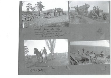 Buninyong & District Historical Society
Photograph - Black and white montage of rural activities at Scotsburn, Various activities including road making by Skelton family at Scotsburn early 20th century
... Various activities including road making by Skelton family at Scotsburn early 20th century...Moving machinery and road repairing on the Skelton family property at Scotsburn in the early 1930s..."Uncle Joe centre making the road to house because Dr. became bogged" "Kitty & Ernest, Tom"...Buninyong & District Historical Society Old Court House, Buninyong Town Hall 313 Learmonth Street Buninyong goldfields Collection of photographs of rural life on Skelton property at Scotsburn early 1930s This photograph shows an example of the rural activities in the early 1930s in Scotsburn Rural Life Scotsburn Skelton Family Transport "Uncle Joe centre making the road to house because Dr. became bogged" "Kitty & Ernest, Tom" Moving machinery and road repairing on the Skelton family property at Scotsburn in the early 1930s Various activities including road making by Skelton family at Scotsburn early 20th century Photograph Black and white montage of rural activities at Scotsburn ...Collection of photographs of rural life on Skelton property at Scotsburn early 1930sThis photograph shows an example of the rural activities in the early 1930s in ScotsburnMoving machinery and road repairing on the Skelton family property at Scotsburn in the early 1930s"Uncle Joe centre making the road to house because Dr. became bogged" "Kitty & Ernest, Tom"rural life, scotsburn, skelton family, transport -
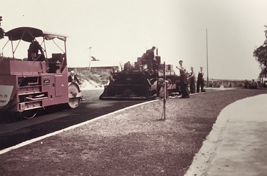 Kew Historical Society Inc
Photograph, Public Works, Road Construction, 1950s
... Public Works, Road Construction...Public works. Road making in the 1950s using a steam roller and a mechanical grader. ...Inscription on reverse: "Road making." ...Public works. Road making in the 1950s using a steam roller and a mechanical grader. ...An original photograph donated to the Kew Historical Society by the City's Engineering Department before the amalgamation of Kew into the City of Boroondara in 1994.While not all of the photographs are of Studley Park, Kew or East Kew, each photo provides a fine snapshot of the work of local government engineering departments of the period. They reveal they types of labour conducted, the techniques used and the equipment and machinery in the possession of the local government authority. Public works. Road making in the 1950s using a steam roller and a mechanical grader. Inscription on reverse: "Road making." city of kew (engineering department), road construction building, road maintenance -
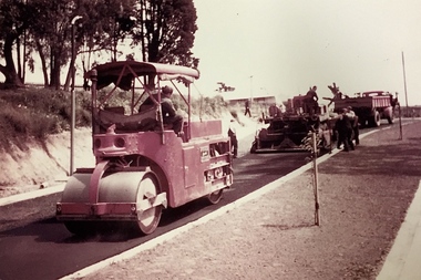 Kew Historical Society Inc
Photograph, Public Works, Road Construction, 1950s
... Public Works, Road Construction...Public works. Road making in the 1950s using a steam roller and a mechanical grader. ...Inscription on reverse: "Road making." ...Public works. Road making in the 1950s using a steam roller and a mechanical grader. ...An original photograph donated to the Kew Historical Society by the City's Engineering Department before the amalgamation of Kew into the City of Boroondara in 1994.While not all of the photographs are of Studley Park, Kew or East Kew, each photo provides a fine snapshot of the work of local government engineering departments of the period. They reveal they types of labour conducted, the techniques used and the equipment and machinery in the possession of the local government authority.Public works. Road making in the 1950s using a steam roller and a mechanical grader. Inscription on reverse: "Road making." city of kew (engineering department), road construction -
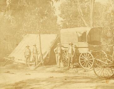 Ringwood and District Historical Society
Photograph, Road making in Ringwood (very old) (undated)
... Road making in Ringwood (very old) (undated)...Catalogue card reads, "Road making in Ringwood (very old)"....Road making in Ringwood (very old) (undated) Photograph ...4 men in front of tent and wagon.Catalogue card reads, "Road making in Ringwood (very old)". -
 Ringwood and District Historical Society
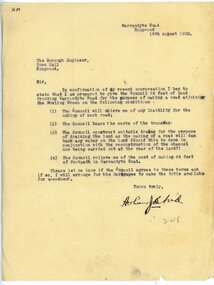
Letter, To Borough Engineer from Arthur Blood confirming gift of land adjoining Bowling Green for road-making purposes
... To Borough Engineer from Arthur Blood confirming gift of land adjoining Bowling Green for road-making purposes. ...It moved to its current location in Loughnan Road, Ringwood in 1997....Typed letter to Ringwood Borough Engineer from Arthur Blood confirming gift of land adjoining Bowling Green for road-making purposes. Dated 10th August 1930....To Borough Engineer from Arthur Blood confirming gift of land adjoining Bowling Green for road-making purposes. Letter ...1929 saw the establishment of the Ringwood Bowls Club initially located on the land now occupied by the Eastland Shopping Centre. It moved to its current location in Loughnan Road, Ringwood in 1997.Typed letter to Ringwood Borough Engineer from Arthur Blood confirming gift of land adjoining Bowling Green for road-making purposes. Dated 10th August 1930.city of ringwood bowls club, ringwood bowling club, ringwood bowls club, lawn bowls, bowling -
 Emerald Museum & Nobelius Heritage Park
Photograph, Mr O'Connor, Making the Road to Clematis, Original Taken c. 1920
... Making the Road to Clematis...In late 1919, the Country Roads Board approved an amendment of the Belgrave-Emerald Road between Gembrook Road (likely now Old Gembrook Road) in Emerald and Paradise (now Clematis) Station. ...A black and white photograph on paper depicting a road construction project. The workers are relying on horses and manual labour to build a road amongst trees and hills. ...Ogilvy Road, Emerald, Victoria, Australia...Making the Road to Clematis Photograph Mr O'Connor ...In late 1919, the Country Roads Board approved an amendment of the Belgrave-Emerald Road between Gembrook Road (likely now Old Gembrook Road) in Emerald and Paradise (now Clematis) Station. This image shows part of those works, where they intersected with Ogilvy Road. Public works projects such as road constructions were popular in the immediate aftermath of the First World War, when many men returned home without work and were eager to earn a living by participating in government projects. This image is a black-and-white copy of the original sepia photograph (VEMUP0996).This image represents an infrastructure project from the 1920s that helped to build the Emerald of today. It displays the tools and technology available for public works projects in the early 20th century, and the manner in which road construction occurred.A black and white photograph on paper depicting a road construction project. The workers are relying on horses and manual labour to build a road amongst trees and hills. The lower-left corner of the photograph is faded - an artefact from the original that this is a copy of, though this copy was made when more of the original was intact.N/Aemerald, clematis, 1920s, transport -
 Eltham District Historical Society Inc
Photograph, George W. Bell, Mavis Gill making a turn near 'Windy' Gale's home, Wild Dog Creek Road, Jan. 1962, Jan 1962
... Mavis Gill making a turn near 'Windy' Gale's home, Wild Dog Creek Road, Jan. 1962...Mavis Gill making a turn near 'Windy' Gale's place Wild Dog Creek area Photo Geo. ...Wild Dog Creek Road, St Andrews, Victoria, Australia...Bell, Jan. 1962 Black and white photo mounted on card Mavis Gill making a turn near 'Windy' Gale's home, Wild Dog Creek Road, Jan. 1962 Photograph Photograph George W. ...Building of Pensioners Cottages at St Andrews; for those burnt out in the 1962 bushfires. A voluntary scheme of Mavis Gill through the Kangaroo Ground Relief CommitteeBlack and white photo mounted on cardMavis Gill making a turn near 'Windy' Gale's place Wild Dog Creek area Photo Geo. W. Bell, Jan. 1962victorian bushfires - 1962, bushfires, dick (windy) gale, fire damage - buildings, george w bell, houses, st andrews, wild dog creek road, mavis gill, pensioners cottages -
 Marysville & District Historical Society
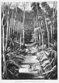
Work on paper (item) - Print of wood engraving, Ebenezer and David Syme, Road Making on the Black Spur, Road to Wood's Point, 1867
... Road Making on the Black Spur, Road to Wood's Point...A copy of an early wood engraving of the construction of the road over the Black Spur in Victoria....A copy of an early wood engraving of the construction of the road over the Black Spur in Victoria....Road Making on the Black Spur, Road to Wood's Point Work on paper Print of wood engraving Ebenezer and David Syme ...A copy of an early wood engraving of the construction of the road over the Black Spur in Victoria.A copy of an early wood engraving of the construction of the road over the Black Spur in Victoria. The Black Spur is known to be one of Victoria's most scenic drives. The road winds through a majestic forest of trees and tree ferns from Healesville to Narbethong and is part of the Maroondah Highway.black spur, wood's point, narbethong, maroondah highway, victoria, wood engraving -
 Creswick Campus Historical Collection - University of Melbourne
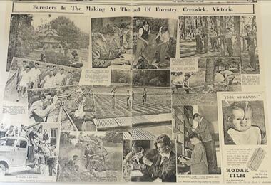
Newspaper - Copy of a two page spread from The Leader - December 10, 1947, Victorian School of Forestry, Foresters in the making at the School of Forestry, Creswick, Victoria, 1947
... Foresters in the making at the School of Forestry, Creswick, Victoria...Two page spread from The Leader, December 10, 1947: Foresters in the making at the School of Forestry, Creswick, Victoria...Foresters in the making at the School of Forestry, Creswick, Victoria...Creswick Campus Historical Collection - University of Melbourne 4 Water Street University of Melbourne Creswick Campus Building 719/718 Creswick goldfields Foresters in the making at the School of Forestry, Creswick, Victoria Two page spread from The Leader, December 10, 1947: Foresters in the making at the School of Forestry, Creswick, Victoria Foresters in the making at the School of Forestry, Creswick, Victoria Newspaper Copy of a two page spread from The Leader - December 10, 1947 Victorian School of Forestry ...Two page spread from The Leader, December 10, 1947: Foresters in the making at the School of Forestry, Creswick, VictoriaForesters in the making at the School of Forestry, Creswick, Victoria -
 Kew Historical Society Inc
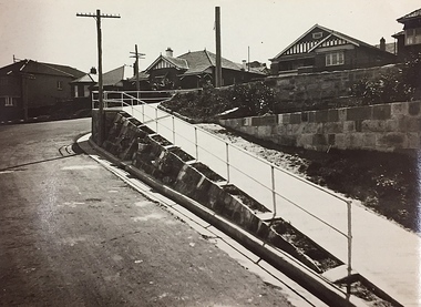
Photograph, City of Kew, Public Works, Road Making, c.1920s
... Public Works, Road Making...A high retaining wall holds back an embankment on a steep slope around which a road turns. It is believed that the photograph dates from the 1920s. .... / Pedestrians using the road in front of the dwellings step off the pathway at the telegraph pole"....Public Works, Road Making Photograph Photograph City of Kew ...An original photograph donated to the Kew Historical Society by the City's Engineering Department before the amalgamation of Kew into the City of Boroondara in 1994. While not all of the photographs are of Studley Park, Kew or East Kew, each photo provides a fine snapshot of the work of local government engineering departments of the period. They reveal they types of labour conducted, the techniques used and the equipment and machinery in the possession of the local government authority.Public works. A high retaining wall holds back an embankment on a steep slope around which a road turns. It is believed that the photograph dates from the 1920s. Inscription on reverse: "A difficult corner designed to obviate the use of steps. / Pedestrians using the road in front of the dwellings step off the pathway at the telegraph pole".city of kew (engineering department), engineering, road construction building -
 Orbost & District Historical Society
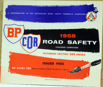
booklet, 1958 Road Safety Colouring Competition, second half 1950's
... 1958 Road Safety Colouring Competition...Between the 1950s and 1970s, road safety was redefined as a medical and social problem, rather than a moral and legal one. ...A booklet of competitions - Road Safety- Victorian Section for Children It was issued by the Australian Road Safety Council. ...Australian Road Safety Council...This item was an important educational tool. road-safety competitions-colouring A booklet of competitions - Road Safety- Victorian Section for Children It was issued by the Australian Road Safety Council. ...Between the 1950s and 1970s, road safety was redefined as a medical and social problem, rather than a moral and legal one. This was a time before seat belts. The Road Safety Colouring Competition was a free colouring competition for children, organised by Commonwealth Oil Refineries Ltd., started in August 1954 with the , aims of teaching road safety. There were 1,000 prizes, valued at £1,200. The winner would receive a £100 bursary and a free plane trip with one parent to Canberra to receive the prize from the Federal Minister for Transport, Senator.G. McLeay. This booklet is the one used by the children in Orbost in 1958. This booklet was designed to promote road safety awareness, with messages and activities specifically considered for children. Its aim was to teach road safety in a fun, but educational way. This item was an important educational tool. A booklet of competitions - Road Safety- Victorian Section for Children It was issued by the Australian Road Safety Council. The front cover is blue, red, black and white. It contains crosswords, colouring competitions with entry forms.road-safety competitions-colouring -
 Greensborough Historical Society
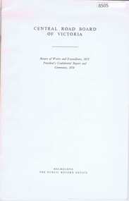
Booklet - Report, Central Road Board Victoria, Return of works and expenditure, 1853; President's confidential report and comments, 1854, by Central Road Board of Victoria, 1854; this reproduction was published by PROV and printed by the Government Printer in 1978
... Return of works and expenditure, 1853; President's confidential report and comments, 1854, by Central Road Board of Victoria...The Central Road Board of Victoria was responsible for making and improving roads in the Colony of Victoria; this facsimile edition of reports by Road Board President Francis Murphy from 1853 and 1854 describe the works undertaken in these formative years of the colony of Victoria....Central Road Board Victoria...Greensborough Historical Society 34A Glenauburn Road Lower Plenty Lower Plenty melbourne The Central Road Board of Victoria was responsible for making and improving roads in the Colony of Victoria; this facsimile edition of reports by Road Board President Francis Murphy from 1853 and 1854 describe the works undertaken in these formative years of the colony of Victoria. roadworks victoria - history roads - victoria 24 p text and tables - facsimile edition Return of works and expenditure, 1853; President's confidential report and comments, 1854, by Central Road Board of Victoria Booklet Report Central Road Board Victoria ...The Central Road Board of Victoria was responsible for making and improving roads in the Colony of Victoria; this facsimile edition of reports by Road Board President Francis Murphy from 1853 and 1854 describe the works undertaken in these formative years of the colony of Victoria.24 p text and tables - facsimile editionroadworks, victoria - history, roads - victoria -
 Greensborough Historical Society
Booklet, History of Delta Road Pre-School Association Incorporated, 1975-1987
... History of Delta Road Pre-School Association Incorporated....Details the history of the Delta Road Pre-School (Watsonia) from initial meetings in 1975 to plan the pre-school up to 1987. ...18-page booklet detailing the history of the Delta Road Pre-School from 1975 to1987. Printed on white paper with pale pink cover....Delta Road Pre-School...Greensborough Historical Society 34A Glenauburn Road Lower Plenty Lower Plenty melbourne Details the history of the Delta Road Pre-School (Watsonia) from initial meetings in 1975 to plan the pre-school up to 1987. ...Details the history of the Delta Road Pre-School (Watsonia) from initial meetings in 1975 to plan the pre-school up to 1987. Contains lists of Committee members and children enrolled at the centre. A detailed history from inception through the first 10 years of operation.18-page booklet detailing the history of the Delta Road Pre-School from 1975 to1987. Printed on white paper with pale pink cover.delta road pre school, watsonia, kindergartens -
 Eltham District Historical Society Inc
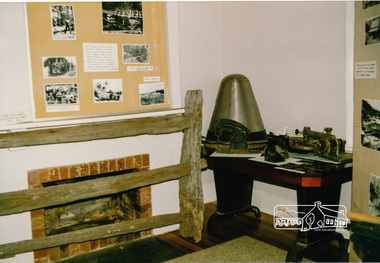
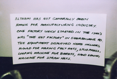
Photograph, Hat making equipment, Heritage Week at 728 Main Road, Eltham, 1990, 1990
... Hat making equipment, Heritage Week at 728 Main Road, Eltham, 1990...Colour photograph of hat making equipment,for Heritage Week display at the Local History Centre (former Courthouse), 728 Main Rod Eltham. ...Hat making equipment, Heritage Week at 728 Main Road, Eltham, 1990 Photograph ...Colour photograph of hat making equipment,for Heritage Week display at the Local History Centre (former Courthouse), 728 Main Rod Eltham. (Home of Eltham District Historical Society) The equipment was used at the Hat Factory in Eltham which started in the 1940s. The equipment shown includes a mould for making felt hats, stud press, looping machine for berets and hand sewing machine for straw hats. Sign accompanying the display is hand written and reads: "Eltham has not generally been known for manufacturing industry. One factory which started in the 1940s was "the hat factory" in Sherbourne Rd. The equipment displayed here includes moulds for making felt hats, stud press, looping machines for berets, hand sewing machine for straw hats."heritage week, eltham, courthouse, hat factory, hat mould, activities -
 Eltham District Historical Society Inc
Photograph, Hat making equipment, Heritage Week at 728 Main Road, Eltham, 1990, 1990
... Hat making equipment, Heritage Week at 728 Main Road, Eltham, 1990...Two Colour photographs of hat making equipment,for Heritage Week display at the Local History Centre (former Courthouse), 728 Main Rod Eltham. ...Hat making equipment, Heritage Week at 728 Main Road, Eltham, 1990 Photograph ...Two Colour photographs of hat making equipment,for Heritage Week display at the Local History Centre (former Courthouse), 728 Main Rod Eltham. (Home of Eltham District Historical Society) The equipment was used at the Hat Factory in Eltham which started in the 1940s. The equipment shown includes a mould for making felt hats, stud press, looping machine for berets and hand sewing machine for straw hats. Sign accompanying the display is hand written and reads: "Eltham has not generally been known for manufacturing industry. One factory which started in the 1940s was "the hat factory" in Sherbourne Rd. The equipment displayed here includes moulds for making felt hats, stud press, looping machines for berets, hand sewing machine for straw hats."heritage week, eltham, courthouse, hat factory, hat mould, activities -
 Melbourne Tram Museum
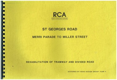
Drawing, Road Construction Authority(RCA), "St Georges Road - Merri Parade to Miller St - Rehabilitation of Tramway and Divided Road", Dec. 1988
... "St Georges Road - Merri Parade to Miller St - Rehabilitation of Tramway and Divided Road"...Prepared Dec. 1988, used 1989. 621.2 Second volume titled "Amended Cross Sections" Prepared by the Road Construction Authority - RCA - Road Design Group Team 2. ...Road Construction Authority(RCA)...Trams tramways Thornbury Northcote Tramways Road Works Construction St Georges Road Set of two comb bound drawings for the "St Georges Road - Merri Parade to Miller St - Rehabilitation of Tramway and Divided Road", stippled card covers, providing details of plans, drainage, cross sections, track locations for the reconstruction of the roadway. ...Set of two comb bound drawings for the "St Georges Road - Merri Parade to Miller St - Rehabilitation of Tramway and Divided Road", stippled card covers, providing details of plans, drainage, cross sections, track locations for the reconstruction of the roadway. Prepared Dec. 1988, used 1989. 621.2 Second volume titled "Amended Cross Sections" Prepared by the Road Construction Authority - RCA - Road Design Group Team 2. See Reg item 2653 for reports prior to the work being undertaken.trams, tramways, thornbury, northcote, tramways, road works, construction, st georges road -
 Whitehorse Historical Society Inc.
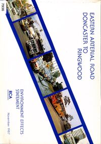
Book - Government Environment Effects Statement, Road Construction Authority (now part of VicRoads), Eastern Arterial Road - Doncaster to Ringwood, November 1987
... Eastern Arterial Road - Doncaster to Ringwood...The Eastern Arterial Road Extension from Doncaster to Ringwood and the Ringwood Bypass was part of the Eastern Corridor Road Development (ECORD) and proposed an extra 11.5 kilometers of freeway mostly along the Koonung and Mullum Mullum creeks in 1987. ...The book covers the Environment Effects Statement for the Eastern Arterial Road Extension from Doncaster to Ringwood and the Ringwood Bypass. ...Road Construction Authority (now part of VicRoads)...Whitehorse Historical Society Inc. 2-10 Deep Creek Road Mitcham melbourne The Eastern Arterial Road Extension from Doncaster to Ringwood and the Ringwood Bypass was part of the Eastern Corridor Road Development (ECORD) and proposed an extra 11.5 kilometers of freeway mostly along the Koonung and Mullum Mullum creeks in 1987. ...The book covers the Environment Effects Statement for the Eastern Arterial Road Extension from Doncaster to Ringwood and the Ringwood Bypass. Aspects covered are development works, traffic affects, public transport, landscape and visual affects, noise, pedestrian/ bicycle access, lighting, air quality and construction affects. Includes maps, cross sections, photos.The book covers the Environment Effects Statement for the Eastern Arterial Road Extension from Doncaster to Ringwood and the Ringwood Bypass. Aspects covered are development works, traffic affects, public transport, landscape and visual affects, noise, pedestrian/ bicycle access, lighting, air quality and construction affects. Includes maps, cross sections, photos.non-fictionThe book covers the Environment Effects Statement for the Eastern Arterial Road Extension from Doncaster to Ringwood and the Ringwood Bypass. Aspects covered are development works, traffic affects, public transport, landscape and visual affects, noise, pedestrian/ bicycle access, lighting, air quality and construction affects. Includes maps, cross sections, photos.eastern freeway extension, eastern arterial road, mullum mullum creek, road construction, environmental impact -
 Whitehorse Historical Society Inc.
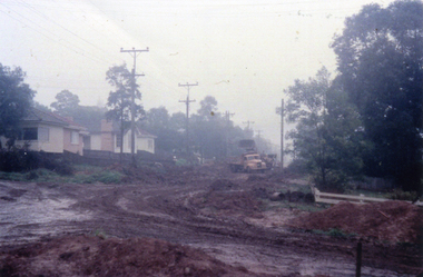
Photograph, Creek Road - road making, 1/06/1961 12:00:00 AM
... Creek Road - road making...Colour photo taken of a 33mm slide of the Creek road being constructed in June 1961 (Note first sign of brick veneer in street.)...Creek Road - road making Photograph Photograph ...Colour photo taken of a 33mm slide of the Creek road being constructed in June 1961 (Note first sign of brick veneer in street.)creek road mitcham, tresider, dot, road construction and maintenance -
 Ballarat Heritage Services
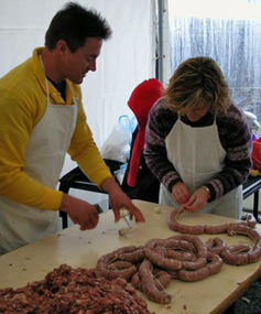
Photograph - Digital photographs, L.J. Gervasoni, Making bullboar during the Hepburn Springs Swiss/Italian Festa, c2004
... Making bullboar during the Hepburn Springs Swiss/Italian Festa...Jeff and Anne Pedretti (Ross) making Bullboar sausages....Main Road, Hepburn Springs, Select an option…, Victoria, Australia...Ballarat Heritage Services PO Box 2209 Bakery Hill Post Office goldfields hepburn hepburn springs swiss italian festa bullboars making bullboar pedretti bullboar sausage Swiss Italian Jeff and Anne Pedretti (Ross) making Bullboar sausages. ...Jeff and Anne Pedretti (Ross) making Bullboar sausages.hepburn, hepburn springs swiss italian festa, bullboars, making bullboar, pedretti, bullboar sausage, swiss italian -
 Melbourne Tram Museum
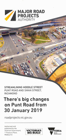
Pamphlet, Major Road Projects Authority, "There's big changes on Punt Road from 30 January 2019", Jan. 2019
... "There's big changes on Punt Road from 30 January 2019"...Pamphlet describing roadworks at Punt Road and Swan St intersection during January and February 2019. ...Major Road Projects Authority...Melbourne Tram Museum 8 Wallen Road Hawthorn melbourne Trams tramways Road Works Punt Rd Swan St Pamphlet describing roadworks at Punt Road and Swan St intersection during January and February 2019. ...Pamphlet describing roadworks at Punt Road and Swan St intersection during January and February 2019. Photo of intersection has a B class at the Punt Road tram stop travelling west towards the city.trams, tramways, road works, punt rd, swan st -
 Melbourne Tram Museum
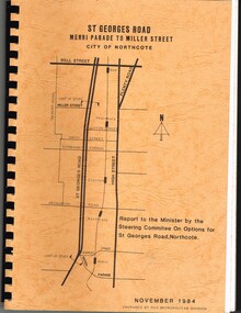
Document - Report, Road Construction Authority - RCA, "Report to the Minister by the Steering Committee on Options for St Georges Road, Northcote", Nov. 1984
... "Report to the Minister by the Steering Committee on Options for St Georges Road, Northcote"...Set of two comb bound, brown covers with a plan of the location on the cover, with a report for the reconstruction of St Georges Road, Merri Parade to Miller St, November 1984. ...Road Construction Authority - RCA...Melbourne Tram Museum 8 Wallen Road Hawthorn melbourne Trams tramways St Georges Rd Thornbury Northcote Tramways Road Works Construction Set of two comb bound, brown covers with a plan of the location on the cover, with a report for the reconstruction of St Georges Road, Merri Parade to Miller St, November 1984. ...Set of two comb bound, brown covers with a plan of the location on the cover, with a report for the reconstruction of St Georges Road, Merri Parade to Miller St, November 1984. First volume is titled "Report to the Minister by the Steering Committee on Options for St Georges Road, Northcote", looks at four different options with sub options. Has drawings for the various options. Second volume - "Steering Committee Recommendations" Prepared by the Road Construction Authority - RCA - Metropolitan Division. See Reg item 621 for the actual drawings.trams, tramways, st georges rd, thornbury, northcote, tramways, road works, construction -
 Kiewa Valley Historical Society
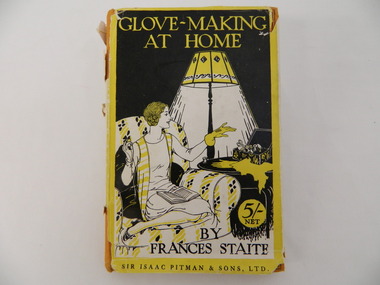
Book - Country Women's Association of Victoria, Glove-Making at Home by Frances Staite, 1927
... Glove-Making at Home by Frances Staite...Inserted in the book is a page with further instructions on glove making. The book is bound and has 90 pages. ...Cover page "Country Womens' Association / of Victoria" stamp with purple ink Title: Clove-Making / At Home / by Frances Staite / Sir Isaac Pitman & Sons, Ltd 5/- net....Inserted in the book is a page with further instructions on glove making. The book is bound and has 90 pages. ...The Tawonga branch of the C.W.A. commenced on the 7th Feb. 1946 and often combined activities with the other branches in the Kiewa Valley. The C.W.A. aimed to improve health, welfare and education for women and children in the country. Doing craft helped the women achieve these aims as they would get together and learn from each other. Women living in Tawonga were mostly on farms and, in 1946, when the branch commenced would have been feeling more remote with WW11 having an effect on available workers and the well being of the women and children.Hard covered book with a yellow and black sleeve. The sleeve has a picture of a lady sitting on a lounge chair under a lamp admiring her glove. Inserted in the book is a page with further instructions on glove making. The book is bound and has 90 pages. The first and last 3 pages consist of advertising.Cover page "Country Womens' Association / of Victoria" stamp with purple ink Title: Clove-Making / At Home / by Frances Staite / Sir Isaac Pitman & Sons, Ltd 5/- net.tawonga. cwa. gloves. craft. country women's association of victoria -
 Glen Eira Historical Society
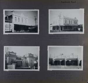
Album - Album page, Kambrook Road, Circa 1972
... Kambrook Road...https://vhd.heritagecouncil.vic.gov.au/places/43737 - re 26 Kambrook Road and 345 Balaclava Road corner building: A prominently situated two-storeyed complex of late Victorian buildings consisting of "Wybar's Buildings" occupying the Balaclava Road/ Kambrook Road corner and the "Caulfield Bakery" facing Kambrook Road, separated by a driveway from a single storeyed shop. ...Page 104 of Photograph Album with four photographs (landscape) of three different properties on Kambrook Road....Handwritten: Kambrook Road [top right] / WYBAR'S BUILDING 1887/ INC CAULFIELD BAKERY / [under top right photo] / 16 KAMBROOK ROAD / 1970 HIRST MRS J.N....26 Kambrook Road, Caulfield North, Melbourne, Victoria, Australia...https://vhd.heritagecouncil.vic.gov.au/places/43737 - re 26 Kambrook Road and 345 Balaclava Road corner building: A prominently situated two-storeyed complex of late Victorian buildings consisting of "Wybar's Buildings" occupying the Balaclava Road/ Kambrook Road corner and the "Caulfield Bakery" facing Kambrook Road, separated by a driveway from a single storeyed shop. ...This photograph is part of the Caulfield Historical Album 1972. This album was created in approximately 1972 as part of a project by the Caulfield Historical Society to assist in identifying buildings worthy of preservation. The album is related to a Survey the Caulfield Historical Society developed in collaboration with the National Trust of Australia (Victoria) and Caulfield City Council to identify historic buildings within the City of Caulfield that warranted the protection of a National Trust Classification. Principal photographer thought to be Trevor Hart, member of Caulfield Historical Society. Most photographs were taken between 1966-1972 with a small number of photographs being older and from unknown sources. All photographs are black and white except where stated, with 386 photographs over 198 pages. https://vhd.heritagecouncil.vic.gov.au/places/43737 - re 26 Kambrook Road and 345 Balaclava Road corner building: A prominently situated two-storeyed complex of late Victorian buildings consisting of "Wybar's Buildings" occupying the Balaclava Road/ Kambrook Road corner and the "Caulfield Bakery" facing Kambrook Road, separated by a driveway from a single storeyed shop. The main building has a comer splay and balustraded parapet with curved pediments, the words "Wybar's Buildings 1887" having been obliterated but "Caulfield Bakery 1887" with the characteristic wheatsheaf surviving in raised cement work. The walls are stuccoed and richly ornamented with bracketed cornices and keystones with masks extending to the Bakery. The main building is further distinguished by the Masonic symbol of the mason's dividers in the pediment whilst the upper level of the bakery is in overpainted brickwork. The single storeyed shop incorporates the bracketed cornice and consoles characteristic of the main buildings and is in other respects a utilitarian structure. https://vhd.heritagecouncil.vic.gov.au/places/35413 - re 16 Kambrook Road A small late Victorian Italianate villa distinguished by its parapeted window bays either side of a small verandah with encaustic tiled floor. The parapets are balustraded with console enrichment and glazed tiles, the stuccoed surfaces being unpainted. Ornamentation is in other respects undistinguished. https://www.gleneira.vic.gov.au/services/planning-and-building/heritage/heritage-management-plan - re 9-11 Kambrook Road ... they demonstrate most of the commonly employed aesthetic devices characteristic of the Italianate Style including patterned brickwork, patterned slate roofs, cast iron lace verandahs, ornamental stucco work and ashlar boards...https://vhd.heritagecouncil.vic.gov.au/places/43737 - 345 Balaclava and 26 Kambrook Roads HO91 in City of Glen Eira "Wybar's Buildings" at the corner of Balaclava Road and Kambrook Road are important as a prominent late Victorian commercial development incorporating a variety of activities including a bakery and possibly a coffee palace, the latter understood to be unique within the municipality, but characteristic of the period. It is a rare complex of its type in Caulfield and is important also as evocative evidence of the late Victorian Land Boom and the creation of a small now defunct commercial centre at this location by the George Wybrow. https://vhd.heritagecouncil.vic.gov.au/places/35413 - 16 Kambrook Road HO121 in City of Glen Eira ''Hollywood'' at 16 Kambrook Road is of architectural interest for its pavilions which retain their unpainted parapets and ornamental tiles in the manner of other less imposing examples in the immediate locality possibly linked with the builder George Wybar and his son, who undertook substantial projects nearby. Its association with James Yorston, presumably is Yorston of Dickson and Yorston, important builders and estate developers at Caulfield during the Inter war period is of interest. https://www.gleneira.vic.gov.au/services/planning-and-building/heritage/heritage-management-plan - re 9-11 Kambrook Road HO152 Normanby Road/Kambrook Road, Caulfield North Statement of Significance: The Precinct is historically significant for its capacity to demonstrate standards of design and building construction in this part of the municipality during the late Land Boom years and especially just prior to the bank collapse of 1891. The housing stock is representative of the standards of amenity excepted by the middle classes of Melbourne society at the time, including artists, (horse) trainers, jockeys, managers, travellers, journalists and the like, also having a functional link with the activities of the Caulfield Racecourse which forms an important element in the history of the Municipality. The row of attached pairs at 5-11 Kambrook Road and 53-67 Kambrook Road is especially significant in this respect in that the narrow allotments are indicative of the owner/developer’s determination to maximise profits at the height of the Land Boom in 1891...Page 104 of Photograph Album with four photographs (landscape) of three different properties on Kambrook Road.Handwritten: Kambrook Road [top right] / WYBAR'S BUILDING 1887/ INC CAULFIELD BAKERY / [under top right photo] / 16 KAMBROOK ROAD / 1970 HIRST MRS J.N.[under bottom left photo] / 11-9 KAMBROOK ROAD / 1970 9-BUCKLAND MRS L.A / 11- ATKINS MRS N.E. [under bottom right photo] / 104 [bottom right]trevor hart, kambrook road, victorian, caulfield north, parapets, wybar's buildings 1887, caulfield bakery 1887, architectural features, painted bricks, balaclava road, victorian italianate style, houses, bay windows, verandahs, glazed tiles, shops, george wybar, builders, james yorston, dickson and yorston, j n hirst, l a buckland, n e atkins, patterned slate roofs, patterned bricks, cast iron work, attached houses -
 Dandenong & District Historical Society
Book, City of Opportunity - The Making of the City of Greater Dandenong
... City of Opportunity - The Making of the City of Greater Dandenong...The Making of the City of Dandenong...Dandenong & District Historical Society 1st Floor, 39 Clow Street Dandenong melbourne The Making of the City of Dandenong City of Opportunity - The Making of the City of Greater Dandenong Book ...non-fiction -
 National Wool Museum
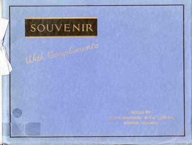
Book, Souvenir edition progress of the cotton industry and textile machinary making
... Souvenir edition progress of the cotton industry and textile machinary making...."Souvenir with Compliments: progress of the cotton industry and textile machinery making" issued by Platt Brothers and Co. Limited, 1929. ...Ltd - progess of the cotton industry and textile machinery making" 1929....Ltd - progess of the cotton industry and textile machinery making" 1929. Souvenir edition progress of the cotton industry and textile machinary making. ..."Souvenir with Compliments: progress of the cotton industry and textile machinery making" issued by Platt Brothers and Co. Limited, 1929. Offers an overview of the cotton industry including its history, examples of English cotton mills and textile machinery for cotton.Book: "Souvenir with compliments from Platt Brothers and Co. Ltd - progess of the cotton industry and textile machinery making" 1929.cotton, textile machinery, textile mills history, platt brothers and co. limited, textile mills - history -
 Ringwood and District Historical Society
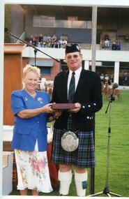
Photograph, Ringwood Highland Games -1998. Sue Macleod making presentation
... Ringwood Highland Games -1998. Sue Macleod making presentation....Sue Macleod making presentation...Ringwood and District Historical Society 125A Warrandyte Road Ringwood North melbourne Sue Macleod making presentation Coloured photograph Ringwood Highland Games -1998. ...Coloured photographSue Macleod making presentation