Showing 331 items matching "roadways"
-
 Linton and District Historical Society Inc
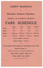
Document - Leaflet, Ansett Roadways Fare Schedule
... Ansett Roadways Fare Schedule...Fare schedule issued by Ansett Roadways for the run Hamilton - Ballarat - Hamilton, early in the history of Reg Ansett's business enterprises. ...Rectangular orange-coloured fare schedule and timetable for Ansett Roadways....Text: ANSETT ROADWAYS / Hamilton - Ballarat - Hamilton / MONDAY TO SATURDAY INCLUSIVE / FARE SCHEDULE....Rectangular orange-coloured fare schedule and timetable for Ansett Roadways. Ansett Roadways Fare Schedule Document Leaflet ...Fare schedule issued by Ansett Roadways for the run Hamilton - Ballarat - Hamilton, early in the history of Reg Ansett's business enterprises. The year this was printed is not known, but fares are in shillings and pence, so it was before 1966.Rectangular orange-coloured fare schedule and timetable for Ansett Roadways.Text: ANSETT ROADWAYS / Hamilton - Ballarat - Hamilton / MONDAY TO SATURDAY INCLUSIVE / FARE SCHEDULE.ansett roadways, sir reginald ansett, road transport -
 Moorabbin Air Museum
Newsletter (Item) - Ansett Roadways " Road News" ( Photo Copies) October 1942 To May 1945
... Ansett Roadways " Road News" ( Photo Copies) October 1942 To May 1945...Moorabbin Air Museum Moorabbin Airport 12 First Street Moorabbin melbourne Ansett Roadways " Road News" ( Photo Copies) October 1942 To May 1945 Newsletter Ansett Roadways " Road News" ( Photo Copies) October 1942 To May 1945 ... -
Moorabbin Air Museum
Book (Item) - The Story Of Ansett Roadways
... The Story Of Ansett Roadways...Moorabbin Air Museum Moorabbin Airport 12 First Street Moorabbin melbourne The Story Of Ansett Roadways Book The Story Of Ansett Roadways ... -
 Halls Gap & Grampians Historical Society
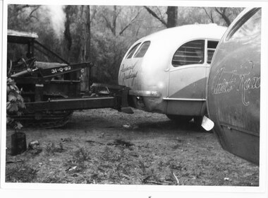
Photograph - B/W
... Photo shows two buses - one Provincial Roadways, the other Ansett Road. Provincial Roadways bus is being pushed by front-end loaded....Writing on back - Zumsteins's camping. Provincial Roadways bus in trouble....Provincial Roadways bus is being pushed by front-end loaded. ...Photo shows two buses - one Provincial Roadways, the other Ansett Road. Provincial Roadways bus is being pushed by front-end loaded.Writing on back - Zumsteins's camping. Provincial Roadways bus in trouble.transport, buses -
 Stawell Historical Society Inc
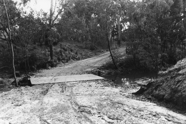
Photograph, Roadway and crossing which was the site of the Glenorchy Weir
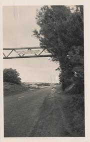
... Roadway and crossing which was the site of the Glenorchy Weir ...Roadway and crossing which was the site of the Glenorchy Weir. ...Black & white photograph showing a steep dirt roadway and crossing over a water body. Trees surrounding the roadway....Roadway and crossing which was the site of the Glenorchy Weir Photograph ...Roadway and crossing which was the site of the Glenorchy Weir. Part of water supply scheme which was completed in 1882 and used until approximately 1900.Black & white photograph showing a steep dirt roadway and crossing over a water body. Trees surrounding the roadway.water river -
 Stawell Historical Society Inc
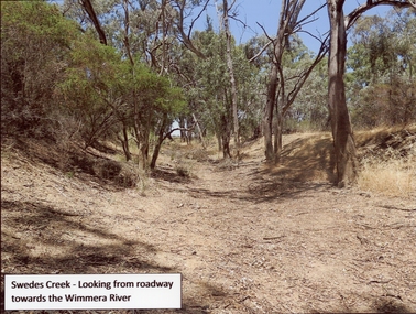
Photograph, Swedes Creek Looking looking towards the Wimmera River 2017 -- Coloured
... Colour Photo of Swedes Creek looking from roadway towards the Wimmera River 2017. (Jan)...Swedes Creek - Looking from roadway towards the Wimmera River....Stawell Historical Society Inc 46 Longfield St Stawell grampians Colour Photo of Swedes Creek looking from roadway towards the Wimmera River 2017. (Jan) water Swedes Creek - Looking from roadway towards the Wimmera River. ...Colour Photo of Swedes Creek looking from roadway towards the Wimmera River 2017. (Jan)Colour photograph of a dry creek bed. Trees along and around the dry creek.Swedes Creek - Looking from roadway towards the Wimmera River.water -
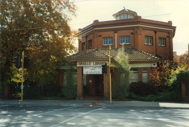 Vision Australia
Photograph - Image, Braille and Talking Book Library building
... This view, taken in the mid-1990's by employee Robert Degraauw, shows the Commercial Road frontage, as well as the pedestrian lights across and the tram tracks in the roadway....Red octagonal brick building facing pedestrian crossing and roadway...This view, taken in the mid-1990's by employee Robert Degraauw, shows the Commercial Road frontage, as well as the pedestrian lights across and the tram tracks in the roadway. Braille & Talking Book Library Robert de Graauw Red octagonal brick building facing pedestrian crossing and roadway Braille and Talking Book Library building Photograph Image Robert Degraauw ...With its distinct octagonal shape, the Braille and Talking Book Library was a distinctive building in Commercial Road. This view, taken in the mid-1990's by employee Robert Degraauw, shows the Commercial Road frontage, as well as the pedestrian lights across and the tram tracks in the roadway.Red octagonal brick building facing pedestrian crossing and roadwaybraille & talking book library, robert de graauw -
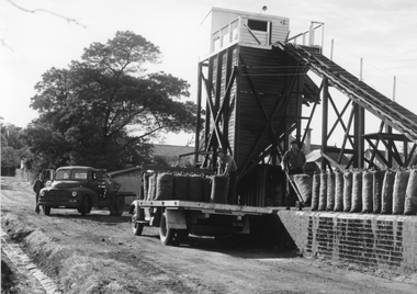 Stawell Historical Society Inc
Photograph, Coke Hopper at the Gas Supply Company with bagged Coke on back of truck, 1945-50
... Two trucks parked on roadway. Bagged Coke on platform and on back of truck....Photgraph of Coke hopper - two trucks parked on a roadway unloading bagged coke onto a platform. ...Photgraph of Coke hopper - two trucks parked on a roadway unloading bagged coke onto a platform. ...Coke Hopper Gas Supply Co. Stawell. Two trucks parked on roadway. Bagged Coke on platform and on back of truck.B/W. Photgraph of Coke hopper - two trucks parked on a roadway unloading bagged coke onto a platform. Four Persons in the picture.stawell industry, gas company -
 University of Melbourne, Burnley Campus Archives
Photograph - Sepia print, A.E. Bennett, Entrance Gates, 1894-1990
... Roadway leading to the Pavilion hidden behind the trees. ...Copy of sepia photograph of the roadway to the Entrance Gates and Curator's Cottage seen in the distance, with the Pavilion on the right, in, "Prize Essays," Alfred E. ...Roadway leading to the Pavilion hidden behind the trees. ...Note by E.B. Littlejohn, "Is the roadway the original Swan Street? Entrance gates to Gardens in the distance. Roadway leading to the Pavilion hidden behind the trees. No elms showing along the roadway," and by T.H. Kneen, "The roadway appears to terminate at the gates outside the Curator's Residence, sweeping past the Pavilion on the right. I have seen a plan which showed an attractive avenue of trees (pine) from the western end of the property (where the Stockman's Cottage was later sited.)" 2 copies sepia photograph. Copy of sepia photograph of the roadway to the Entrance Gates and Curator's Cottage seen in the distance, with the Pavilion on the right, in, "Prize Essays," Alfred E. Bennett, c.1894, after p 116. Pinus radiata avenue on each side of the road.entrance gates, prize essays, alfred e. bennett, curator's residence, pavilion, stockman's cottage, pine tree avenue -
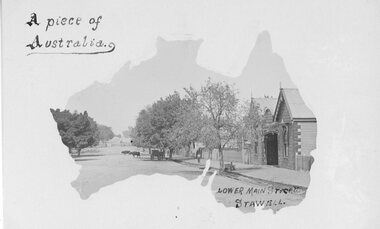 Stawell Historical Society Inc
Postcard, Railway Hotel in Lower Main Street Stawell c1900 -- Postcard
... Postcard with Australia outline Wooden Railway Hotel Lower Main Street Stawell c1900 with Cattle on roadway near rail crossing. By the "Merle Studio" Main Street Stawell....Postcard with Australia outline Wooden Railway Hotel Lower Main Street Stawell c1900 with Cattle on roadway near rail crossing. By the "Merle Studio" Main Street Stawell....Stawell Postcard with Australia outline Wooden Railway Hotel Lower Main Street Stawell c1900 with Cattle on roadway near rail crossing. By the "Merle Studio" Main Street Stawell. ...Postcard with Australia outline Wooden Railway Hotel Lower Main Street Stawell c1900 with Cattle on roadway near rail crossing. By the "Merle Studio" Main Street Stawell.Postcard with Australia outline Wooden Railway Hotel Lower Main Street Stawell c1900 with Cattle on roadway near rail crossing. By the "Merle Studio" Main Street Stawell.stawell -
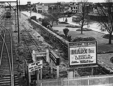 Sunshine and District Historical Society Incorporated
Photograph - Sunshine Gardens Bendigo line McKay factory clock Business shops Roadway of Hampshire Road and Sunshine Theatre Billboard Photograph, Late 1940s
... Sunshine Gardens Bendigo line McKay factory clock Business shops Roadway of Hampshire Road and Sunshine Theatre Billboard Photograph...Photos taken from footbridge over rail lines adjacent to Sunshine Railway Station Gives a perspective view of Sunshine Gardens Bendigo line McKay factory clock business shops roadway of Hampshire Road motor vehicles tramways bus and billboard depicting picture theatre shows Billboard says Sunshine Theatre Phone MW 9140 The Merry Mad MARX Bros A Night in Casablanca Paulette Gollard Diary of a Chamber Maid This photo was reproduced for part of a display in Sunshine Librarys Interpretive Centre early 1997...McKay Memorial Gardens Anderson Road Sunshine Photos taken from footbridge over rail lines adjacent to Sunshine Railway Station Gives a perspective view of Sunshine Gardens Bendigo line McKay factory clock business shops roadway of Hampshire Road motor vehicles tramways bus and billboard depicting picture theatre shows Billboard says Sunshine Theatre Phone MW 9140 The Merry Mad MARX Bros A Night in Casablanca Paulette Gollard Diary of a Chamber Maid This photo was reproduced for part of a display in Sunshine Librarys Interpretive Centre early 1997 Sunshine Gardens Bendigo line McKay factory clock Business shops Roadway of Hampshire Road and Sunshine Theatre Billboard Photograph Photograph Sunshine Gardens Bendigo line McKay factory clock Business shops Roadway of Hampshire Road and Sunshine Theatre Billboard Photograph ...Photos taken from footbridge over rail lines adjacent to Sunshine Railway Station Gives a perspective view of Sunshine Gardens Bendigo line McKay factory clock business shops roadway of Hampshire Road motor vehicles tramways bus and billboard depicting picture theatre shows Billboard says Sunshine Theatre Phone MW 9140 The Merry Mad MARX Bros A Night in Casablanca Paulette Gollard Diary of a Chamber Maid This photo was reproduced for part of a display in Sunshine Librarys Interpretive Centre early 1997sunshine gardens, h.v. mckay memorial gardens, anderson road, sunshine -
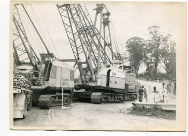 Orbost & District Historical Society
black and white photographs, 1974 - 1976
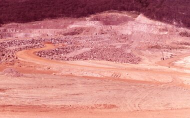
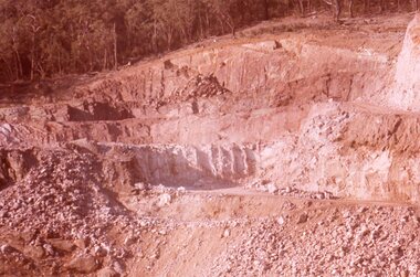
... Construction of the roadway embankment between the bridges across the Snowy River flood plains at Orbost commenced in January 1974 and was completed in November 1976. ...Four black / white photographs of construction sites. 3241.1 is of three cranes and other machinery with six persons. 3241.2 is of workmen working on flooded site. 3241.3 is a photograph of the early stages of construction of a bridge looking towards the township. 3241.4 shows the construction of a roadway between the bridges....Orbost & District Historical Society Ruskin Street Orbost gippsland Construction of the roadway embankment between the bridges across the Snowy River flood plains at Orbost commenced in January 1974 and was completed in November 1976. ...Construction of the roadway embankment between the bridges across the Snowy River flood plains at Orbost commenced in January 1974 and was completed in November 1976. Pearsons were the bridge contractors for the construction of the Princes Freeway and bridges across the river flood plains at Orbost. Heavy rains and floods held up progress.These photographs are of the construction of a major structure in Orbost. The opening of this Snowy River Bridge was an important development in the accessibility to the township of Orbost.Four black / white photographs of construction sites. 3241.1 is of three cranes and other machinery with six persons. 3241.2 is of workmen working on flooded site. 3241.3 is a photograph of the early stages of construction of a bridge looking towards the township. 3241.4 shows the construction of a roadway between the bridges.construction-snowy-river-bridge bridge-orbost -
![Photograph - Construction of the F19 [Eastern Freeway], Ron Setford, July 1976](/media/collectors/550653872162f11fb04854aa/items/6808cb76025de50d1e7414e2/item-media/6808cb90025de50d1e741680/item-fit-380x285.jpg?cb=6) Kew Historical Society Inc
Kew Historical Society IncPhotograph - Construction of the F19 [Eastern Freeway], Ron Setford, July 1976
... "Across Roadway to tunnel / F19 / 7/76"...Ron Setford Eastern Freeway F19 Freeway "Across Roadway to tunnel / F19 / 7/76" Photograph Construction of the F19 [Eastern Freeway] Ron Setford ...Ron Setford and his wife Grace Setford lived in Tanner Avenue, East Kew, from c.1946 to c.1995. A keen photographer, he recorded the changing face of Kew over a 20 year period. Apart from 30 photographs of built structures and places in Kew dating from 1960 and 1961, 145 of his 35mm colour slides chronicle the development of the F19 (later renamed Eastern) Freeway through the Yarra Valley in Kew over a five year period from c.1972 to c.1977. This important collection was donated to the Society by his granddaughter in 2025.This collection of 175 35mm slides is of local and statewide significance, owing to its subject matter, particularly the major development of road transport infrastructure during the 1970s with the construction of the Eastern Freeway. The photographer also took care to annotate and date most of his slides which enable the researcher to pinpoint temporal and spatial locations."Across Roadway to tunnel / F19 / 7/76"ron setford, eastern freeway, f19 freeway -
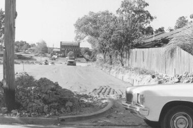 Ringwood and District Historical Society
Photograph, Road construction works for Target Square Shopping Centre, viewed towards Charter and Seymour Streets from Bond Street, Ringwood - 1984
... Written on back of photograph, "New roadway leading to Target"....Ringwood and District Historical Society 125A Warrandyte Road Ringwood North melbourne Written on back of photograph, "New roadway leading to Target". Road construction works for Target Square Shopping Centre, viewed towards Charter and Seymour Streets from Bond Street, Ringwood - 1984. ...Written on back of photograph, "New roadway leading to Target". -
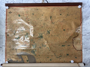 Sunshine and District Historical Society Incorporated
Map - Wall Map Melbourne & Suburbs
... Wall map with Melborune & suburbs showing bay and roadways...Map Wall map with Melborune & suburbs showing bay and roadways Laminated paper poster of Melbourne and suburbs - undated Map Wall Map Melbourne & Suburbs ...Wall map with Melborune & suburbs showing bay and roadwaysmap -
 Stawell Historical Society Inc
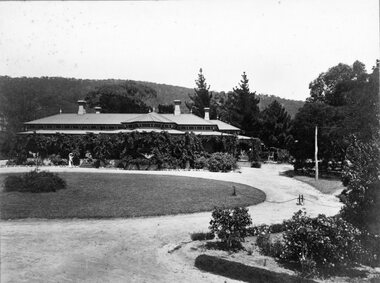
Photograph, Glen Holford Homestead Pomonal
... Homestead with Grampians Range in background. Roadway at front....Destroyed by Fire 1920's Homestead with Grampians Range in background. Roadway at front. Glen Holford Homestead Pomonal Photograph ...Homestead with Grampians Range in background. Roadway at front.At Pomonal. Home of Alan Holford Wettenhall. Destroyed by Fire 1920's -
 Ballarat Heritage Services
Photograph, Clare Gervasoni, Brookside Homestead, 21/01/2021
... Brookside Homestead taken from the public roadway....Brookside farm homestead Brookside Homestead taken from the public roadway. Brookside Homestead Photograph Clare Gervasoni ...The Brookside Private Reformatory for Protestant Girls was established on 29 December 1887 by Mrs W. T. Rowe. It was initially established at Glenfine, and soon moved to more extensive premises in the town of Cape Clear, near Scarsdale. The establishement of private reformatories had been made possible by The Juvenile Offenders' Act 1887 , which was assented to only weeks before the opening of Brookside. The Mintaro Reformatory Home for Girls at Monegeetta, Lancefield was established in 1903 by the Methodist Home Mission Department to take the girls from the Brookside Reformatory at Cape Clear when it closed in 1903. Brookside Homestead taken from the public roadway.brookside, farm, homestead -
 Ballarat Heritage Services
Photograph, Clare Gervasoni, Stable Complex at Brookside, 21/01/2021
... Brookside Homestead taken from the public roadway....Ballarat Heritage Services PO Box 2209 Bakery Hill Post Office goldfields Brookside farm stable Brookside Homestead taken from the public roadway. Stable Complex at Brookside Photograph Clare Gervasoni ...Brookside Homestead taken from the public roadway.brookside, farm, stable -
 Wodonga & District Historical Society Inc
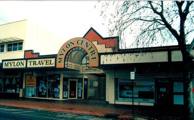
Photograph - Mylon Centre, Wodonga
... A colour photo depicting the front of a building and roadway....Mylon Motorways Mylon Travel Centre Wodonga Businesses Above building: MYLON TRAVEL / MYLON CENTRE A colour photo depicting the front of a building and roadway. Mylon Centre, Wodonga Photograph Mylon Centre, Wodonga ...In 1906 Patrick Mylon started a passenger transport service in the Albury-Wodonga border area with horses and cabs. His son Jack went into business in the late 1920s, and his grandson Bernie joined the firm early in 1970. When Patrick started with the horses and cabs, each cab carried eight passengers and he always had two horses per cab. As the business expanded, Mylons used a range of buses and coaches including Reo, Chev and Bedford vehicles. Mylon Travel Centre opened at 152 High Street, Wodonga on 21 November 1992. It allowed Mylons to extend their service for holidaymakers. Mylon’s staff could help with all holiday needs, including answering questions about destinations as well as booking tours, accommodation, concert seats and express coach bookings. The new Centre had a computerised reservation system with direct link-up for world-wide reservations. During more than 100 years of service to the Wodonga region and beyond, Mylon Motorways received many awards for Excellence and tourism. On July 2, 2008 the company, including its 31 buses and 45 staff members were transferred to the Dyson Group.This building was part of a major local company which serviced Wodonga for over 100 years.A colour photo depicting the front of a building and roadway.Above building: MYLON TRAVEL / MYLON CENTREmylon motorways, mylon travel centre, wodonga businesses -
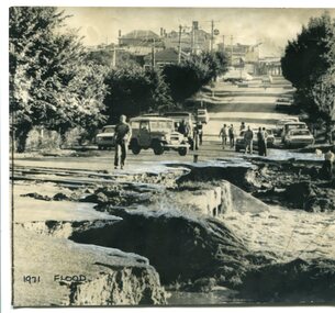 Orbost & District Historical Society
Photograph - 1971 flood, Orbost, The Herald, 8.2.1971
... A b/w photo showing severe damage to a roadway in the foreground, people walking on the intact roadway behind, and the road leading up a hill through buildings. ...A b/w photo showing severe damage to a roadway in the foreground, people walking on the intact roadway behind, and the road leading up a hill through buildings. ...This is one of many photos taken following the devastating Snowy River flood of 1971 which inflicted huge impact on the Orbost area, including access roads to Orbost. This photo shows road damage at the southern end of Nicholson Street, adjacent to the Snowy River. This was the main road leading in to Orbost and also the Princes Highway in 1971. Orbost was completely cut off for several days following this flood. This photo is significant because it shows the impact of the 1971 Snowy River flood on the main road leading into Orbost. A b/w photo showing severe damage to a roadway in the foreground, people walking on the intact roadway behind, and the road leading up a hill through buildings. Written in black ink below the photo: '1971 flood'. Written on the back of the photo: 'Orbost and its 3,000 people in East Gippsland were cut off today by 50 square miles of Snowy River floodway. The washed out Princes Highway a quarter mile on the Melbourne side of Orbost in East Gippsland, today. ln the background is Orbost's main street'.orbost, snowy river, 1971 flood damage -
 Stawell Historical Society Inc
Photograph, "Dane" Memorial Seat near Big Hill Stawell -- Coloured
... Colour Photograph of Dane Brick Seat. Roadway on right....Colour image Stawell Colour Photograph of Dane Brick Seat. Roadway on right. "Dane" Memorial Seat near Big Hill Stawell -- Coloured Photograph ...Brick Seat at foot of Big Hill. Colour imageColour Photograph of Dane Brick Seat. Roadway on right.stawell -
 Stawell Historical Society Inc
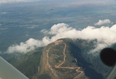
Slide, Ian McCann, Aerial View of Mt Willaim, 1960's
... Aerial View of Mt William showing the roadway to the summit ...Stawell Historical Society Inc 46 Longfield St Stawell grampians Grampians Mt Willaim Aerial View of Mt William showing the roadway to the summit Aerial View of Mt Willaim Slide Ian McCann ...Aerial View of Mt William showing the roadway to the summit grampians, mt willaim -
 Stawell Historical Society Inc
Photograph, Dunmunkle Creek looking towards Wimmera River 2017 -- Coloured
... Dunmunkle Cree looking towards Wimmera River from roadway - 2017....Stawell Historical Society Inc 46 Longfield St Stawell grampians Colour Photo of Dunmunkle Creek looking towards Wimmera River 2017. water Dunmunkle Cree looking towards Wimmera River from roadway - 2017. Colour photograph of dry creek bed surrounded by vegetation. ...Colour Photo of Dunmunkle Creek looking towards Wimmera River 2017.Colour photograph of dry creek bed surrounded by vegetation. Dunmunkle Cree looking towards Wimmera River from roadway - 2017.water -
 Phillip Island and District Historical Society Inc.
Photograph, 1940's
... Black & White photograph of roadway to the Bridge from Newhaven side....Phillip Island and District Historical Society Inc. phillip-island-and-the-bass-coast One of 20 photographs/postcards donated by Mary Karney suspension bridge san remo/phillip island phillip island suspension bridge bridges phillip island mary karney Sign across the road before the bridge: Load limit 6 tons gross - Speed limit 20 MPH Black & White photograph of roadway to the Bridge from Newhaven side. Photograph Photograph ...One of 20 photographs/postcards donated by Mary KarneyBlack & White photograph of roadway to the Bridge from Newhaven side.Sign across the road before the bridge: Load limit 6 tons gross - Speed limit 20 MPHsuspension bridge san remo/phillip island, phillip island suspension bridge, bridges, phillip island, mary karney -
 Stawell Historical Society Inc
Slide, Ian McCann, Roadway at the dam bottom, 1965
... Roadway at the dam bottom...Colour Slide: Showing a roadway at he bottom of lake bellfield...Stawell Historical Society Inc 46 Longfield St Stawell grampians Lake Bellfield Colour Slide: Showing a roadway at he bottom of lake bellfield Roadway at the dam bottom Slide Ian McCann ...Colour Slide: Showing a roadway at he bottom of lake bellfieldlake bellfield -
 Stawell Historical Society Inc
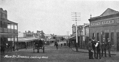
Photograph, Main Street Stawell looking West c1907. Kay's Star Hotel on Right
... For many years it stood in the centre of the roadway in Main Street and had to be moved to give more room for traffic. ...Group of men talking in roadway at right. Telegraph pole prominent near centre of photo....Group of men talking in roadway at right. Telegraph pole prominent near centre of photo. ...Main Street Looking West. Kays Star Hotel c1907 The Star Hotel had a chequered life. Like a number of other hotels it started life on Commercial Street Pleasant Creek, the first License being held by Mr. William Francis in 1858. It was shifted to Main Street Quartz Reefs in 1860 and had many tenants over a long period. For many years it stood in the centre of the roadway in Main Street and had to be moved to give more room for traffic. It is one of the reasons we have a bend in the Main Street. As a Hotel it had 54 years without a conviction against it. Although it had many licensees it was owned by one family for the last 27 years of its life as a Hotel. It was delicensed in 1916 because it was too close to the Albion which was a better building. Currently (2025) occupied by the Stawell Club and is licensed. The walkway beside it to the carpark is names Star Lane.Main Street Stawell looking West c1907. Bull & Mouth Hotel with verandahs on Left, Kay's Star Hotel on Right. Group of men talking in roadway at right. Telegraph pole prominent near centre of photo.Main St. Stawell Looking West.stawell, hotel -
 Stawell Historical Society Inc
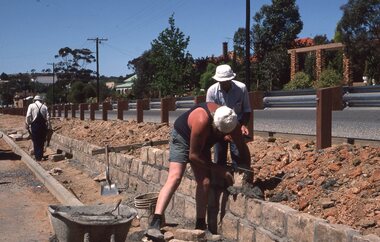
Photograph - Slides, Ian McCann, Seaby Street Construction November 82, 1976-1984
... Colour Photgraph 3 Men laying Stones between devided roadway...Stawell Historical Society Inc 46 Longfield St Stawell grampians Colour Photgraph 3 Men laying Stones between devided roadway Seaby Street Construction November 82 Photograph Slides Ian McCann ...Colour Photgraph 3 Men laying Stones between devided roadway -
 Stawell Historical Society Inc
Slide, Ian McCann, Roadway around the dam, 1965
... Roadway around the dam...Colour Slide: Showin the roadway around the dam that was used during construction....Roadway around the dam Slide Ian McCann ...Colour Slide: Showin the roadway around the dam that was used during construction.lake bellfield -
 Lakes Entrance Historical Society
Postcard - Whiters Camp Park Lakes Entrance 1935, Mona McLeod
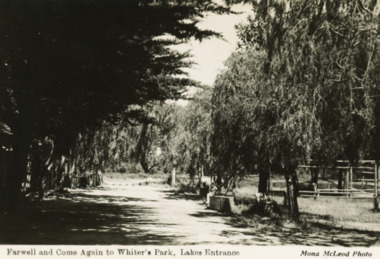
... ...roadways...Camping Businesses roadways Farewell and Come Again to Whiters Park Lakes Entrance Black and white postcard of back entry or exit through tree lined driveway of Whiters Camp Park Lakes Entrance Victoria Postcard Whiters Camp Park Lakes Entrance 1935 Mona McLeod ...Black and white postcard of back entry or exit through tree lined driveway of Whiters Camp Park Lakes Entrance VictoriaFarewell and Come Again to Whiters Park Lakes Entrancecamping, businesses, roadways -
 Bendigo Historical Society Inc.
Photograph - FRIENDS OF WHITE HILLS CEMETERY COLLECTION: COPY OF COLOURED PHOTOGRAPH
... Copy of a coloured photograph of roadway overgrown with weeds at White Hills Cemetery....History House 11 Mackenzie Street Bendigo goldfields PHOTOGRAPH Streetscape roadway overgrown of weeds Photograph. Copy of a coloured photograph of roadway overgrown with weeds at White Hills Cemetery. ...Photograph. Copy of a coloured photograph of roadway overgrown with weeds at White Hills Cemetery.photograph, streetscape, roadway overgrown of weeds