Showing 90 items matching "robert reynolds"
-
 Bendigo Historical Society Inc.
Document - The Reynolds Family Records Collection (Folder 1 of 4) - Charles Albion Reynolds, his son Robert Reynolds (1894-1916), Abt 2005
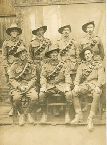
... The Reynolds Family Records Collection (Folder 1 of 4) - Charles Albion Reynolds, his son Robert Reynolds (1894-1916)......robert reynolds...This item contains the following documents: 10891.9a Family history sheet Robert Reynolds. 10891.9b Typed sheet with details and dates on Robert 10891.9c Military Entrance Regulation Authority Book issued to Robert Reynolds 10891.9d Post card Seven soldiers - on rear: Robert Reynolds standing at end right possibly taken at Watsonia 10891.9e Post card portrait of Robert Reynolds: on rear is written "to dear Frank from amelia in loving memory of my darling brother Robert, died 31st Jan 1916 10891.9f Unknown group of workers, possibly Robert standing at the right-hand side. 10891.9g Group of soldiers 10891.9h Robert Reynolds on the end of the row at Simpson Barracks Watsonia, Victoria...Robert Reynolds is the Grandson of Richard Reynolds and Eleanor Hinde. ...Eleanor Hinde (1842-1902) was born in Lancashire England. In 1858, Eleanor married Richard Reynolds in the Forest Street Wesleyan Methodist Church in Sandhurst. They both gave their address as Sailors Gully Goldfields. They had seven children together. Richard was a skilled tradesman and after he died in 1872 from lung disease, Eleanor married Arculus Opie. Eleanor owned a property on the corner of Gladstone and Stanley Streets which later became an electrical substation. She sold poultry and eggs and preserves. The four folders contain family history documents and photos of the descendants of Eleanor Hinde. Robert Reynolds is the Grandson of Richard Reynolds and Eleanor Hinde. This item contains the following documents: 10891.9a Family history sheet Robert Reynolds. 10891.9b Typed sheet with details and dates on Robert 10891.9c Military Entrance Regulation Authority Book issued to Robert Reynolds 10891.9d Post card Seven soldiers - on rear: Robert Reynolds standing at end right possibly taken at Watsonia 10891.9e Post card portrait of Robert Reynolds: on rear is written "to dear Frank from amelia in loving memory of my darling brother Robert, died 31st Jan 1916 10891.9f Unknown group of workers, possibly Robert standing at the right-hand side. 10891.9g Group of soldiers 10891.9h Robert Reynolds on the end of the row at Simpson Barracks Watsonia, Victoriabendigo, sandhurst, peter jorgensen, eleanor hinde, eleanor reynolds, eleanor opie, reynolds collection, amelia honorah reynolds, charles frank greenaway, charles albion reynolds, iris ellen greenaway, william donald male, ruth honora greenaway, dirk pendavingh, percy george tobias, louisa catherine reynolds, lois noelle tobias, lois mitchell, lois tobias, robert reynolds -
 Bendigo Historical Society Inc.
Document - The Reynolds Family Records Collection (Folder 4 of 4) Robert Reynolds and Unknown Group, Abt 1913
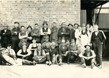
... The Reynolds Family Records Collection (Folder 4 of 4) Robert Reynolds and Unknown Group......robert reynolds...This item contains the following documents: Black and White Photo of Robert Reynolds (in suit) and Unknown group, taken by V. ...This item contains the following documents: Black and White Photo of Robert Reynolds (in suit) and Unknown group, taken by V. ...Eleanor Hinde (1842-1902) was born in Lancashire England. In 1858, Eleanor married Richard Reynold in the Forest St Wesleyn Methodist Church in Sandhurst. They both gave their address as Sailors Gully Goldfields. They had seven children together. Richard was a skilled tradesman and after he died in 1872 from lung disease, Eleanor married Arculus Opie. Eleanor owned a property on the corner of Gladstone and Stanley Streets which later became an electrical substation. She sold poultry and eggs and preserves. One of Eleanor's sons, William John, married Anna (Annie) Jorgensen, and one of her daughters. Amelia, married Anna's brother Thomas Joynes Jorgensen. The Jorgensens founded and managed Jorgensen and Sons foundry and engineering works. Peter Jorgensen (1849-1914), was a mining contractor, he lived at, "Bro," Russell street, Quarry Hill. His firm was Jorgensen and Sons, mining contractors. He was a native of the Island of Alsen, Denmark. He left Denmark in the year 1861, embarking at Hamburg in a small sailing Ship. The four folders contain family history documents and photos of the descendants of Eleanor Hinde. This item contains the following documents: Black and White Photo of Robert Reynolds (in suit) and Unknown group, taken by V. Sheenan, in about 1913, Robert died in 1916bendigo, sandhurst, peter jorgensen, eleanor hinde, eleanor reynolds, eleanor opie, reynolds collection, robert reynolds -
 Bendigo Historical Society Inc.
Document - The Reynolds Family Records Collection (Folder 4 of 4) Robert Reynolds 51st Infrantry, 1914
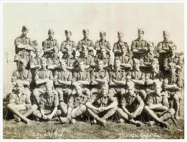
... The Reynolds Family Records Collection (Folder 4 of 4) Robert Reynolds 51st Infrantry......robert reynolds...This item contains the following documents: Photo of Robert Reynolds, 3rd from left seated; and 31 other uniformed soldiers of 51st Infrantry at Lilydale Victoria, camp 1914...This item contains the following documents: Photo of Robert Reynolds, 3rd from left seated; and 31 other uniformed soldiers of 51st Infrantry at Lilydale Victoria, camp 1914 Document The Reynolds Family Records Collection (Folder 4 of 4) Robert Reynolds 51st Infrantry ...Eleanor Hinde (1842-1902) was born in Lancashire England. In 1858, Eleanor married Richard Reynold in the Forest St Wesleyn Methodist Church in Sandhurst. They both gave their address as Sailors Gully Goldfields. They had seven children together. Richard was a skilled tradesman and after he died in 1872 from lung disease, Eleanor married Arculus Opie. Eleanor owned a property on the corner of Gladstone and Stanley Streets which later became an electrical substation. She sold poultry and eggs and preserves. One of Eleanor's sons, William John, married Anna (Annie) Jorgensen, and one of her daughters. Amelia, married Anna's brother Thomas Joynes Jorgensen. The Jorgensens founded and managed Jorgensen and Sons foundry and engineering works. Peter Jorgensen (1849-1914), was a mining contractor, he lived at, "Bro," Russell street, Quarry Hill. His firm was Jorgensen and Sons, mining contractors. He was a native of the Island of Alsen, Denmark. He left Denmark in the year 1861, embarking at Hamburg in a small sailing Ship. The four folders contain family history documents and photos of the descendants of Eleanor Hinde. This item contains the following documents: Photo of Robert Reynolds, 3rd from left seated; and 31 other uniformed soldiers of 51st Infrantry at Lilydale Victoria, camp 1914bendigo, sandhurst, peter jorgensen, eleanor hinde, eleanor reynolds, eleanor opie, reynolds collection, robert reynolds, 51st infrantry -
 Bendigo Historical Society Inc.
Document - The Reynolds Family Records Collection (Folder 4 of 4) Photos of the Reynold Cousins, Abt 2005
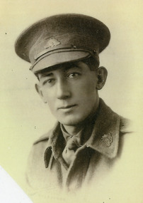
... ...robert reynolds...This item contains the following documents: Photos of the Reynolds Cousins - Notes from the rear of the photos. 10894.7a Lennox Joynes Jorgensen 23/2/1898 Bendigo to 1993 10894.7b Raymond Gifford Reynolds (Military Medal) 1895 Bendigo 10894.7c Robert Reynolds 23/11/1894 Lalbert, Victoria to 1916 10894.7d Clement Gladstone Reynolds 19/4/1898 to 1898 Bendigo, to 1972 The four were the sons of brothers Charles, William and Harry (sister Amelia). ...He left Denmark in the year 1861, embarking at Hamburg in a small sailing Ship. bendigo sandhurst peter jorgensen eleanor hinde eleanor reynolds eleanor opie reynolds collection reymond clifford reynolds lennox koynes jorgensens clement gladstone reynolds robert reynolds The four folders contain family history documents and photos of the descendants of Eleanor Hinde. ...Eleanor Hinde (1842-1902) was born in Lancashire England. In 1858, Eleanor married Richard Reynold in the Forest St Wesleyn Methodist Church in Sandhurst. They both gave their address as Sailors Gully Goldfields. They had seven children together. Richard was a skilled tradesman and after he died in 1872 from lung disease, Eleanor married Arculus Opie. Eleanor owned a property on the corner of Gladstone and Stanley Streets which later became an electrical substation. She sold poultry and eggs and preserves. One of Eleanor's sons, William John, married Anna (Annie) Jorgensen, and one of her daughters. Amelia, married Anna's brother Thomas Joynes Jorgensen. The Jorgensens founded and managed Jorgensen and Sons foundry and engineering works. Peter Jorgensen (1849-1914), was a mining contractor, he lived at, "Bro," Russell street, Quarry Hill. His firm was Jorgensen and Sons, mining contractors. He was a native of the Island of Alsen, Denmark. He left Denmark in the year 1861, embarking at Hamburg in a small sailing Ship. The four folders contain family history documents and photos of the descendants of Eleanor Hinde. This item contains the following documents: Photos of the Reynolds Cousins - Notes from the rear of the photos. 10894.7a Lennox Joynes Jorgensen 23/2/1898 Bendigo to 1993 10894.7b Raymond Gifford Reynolds (Military Medal) 1895 Bendigo 10894.7c Robert Reynolds 23/11/1894 Lalbert, Victoria to 1916 10894.7d Clement Gladstone Reynolds 19/4/1898 to 1898 Bendigo, to 1972 The four were the sons of brothers Charles, William and Harry (sister Amelia). They were first cousins of each other.bendigo, sandhurst, peter jorgensen, eleanor hinde, eleanor reynolds, eleanor opie, reynolds collection, reymond clifford reynolds, lennox koynes jorgensens, clement gladstone reynolds, robert reynolds -
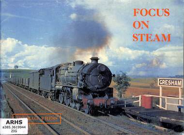 Victorian Railway History Library
Book, Allerton, David, Focus On Steam, 1973
... Robert...O'Neil, Shane...Reynolds...Focus On Steam Book Allerton, David Allerton, John Attenborough, Peter Dawbin, Bruce Gray, Ian Gaydon, John Holdsworth, Malcolm Kingsford-Smith, Robert O'Neil, Shane Reynolds, Bruce Shield, David Stevens, George Wilson, Robert Dunn, Ian Merchant, Robert Zig Zag Press ...A daybreak to Daybreak pictorial portrayal of latter day steam operations on the N.S.W.G.R.ill, p.56.non-fictionA daybreak to Daybreak pictorial portrayal of latter day steam operations on the N.S.W.G.R.steam locomotives - nsw – pictorial, railroad operations - new south wales - history -
 Bendigo Historical Society Inc.
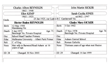
Document - The Reynolds Family Records Collection (Folder 1 of 4) - Charles Albion Reynolds, his son Hector Baden Reynolds (1900-1972), Abt 2005
... ...robert reynolds...She sold poultry and eggs and preserves. bendigo sandhurst peter jorgensen eleanor hinde eleanor reynolds eleanor opie reynolds collection amelia honorah reynolds charles frank greenaway charles albion reynolds iris ellen greenaway william donald male ruth honora greenaway dirk pendavingh percy george tobias louisa catherine reynolds lois noelle tobias lois mitchell lois tobias robert reynolds hector baden reynolds The four folders contain family history documents and photos of the descendants of Eleanor Hinde. ...Eleanor Hinde (1842-1902) was born in Lancashire England. In 1858, Eleanor married Richard Reynolds in the Forest Street Wesleyan Methodist Church in Sandhurst. They both gave their address as Sailors Gully Goldfields. They had seven children together. Richard was a skilled tradesman and after he died in 1872 from lung disease, Eleanor married Arculus Opie. Eleanor owned a property on the corner of Gladstone and Stanley Streets which later became an electrical substation. She sold poultry and eggs and preserves. The four folders contain family history documents and photos of the descendants of Eleanor Hinde. Hector Reynolds is the Grandson of Richard Reynolds and Eleanor Hinde. This item contains the following documents: 10891.10a Family History Sheet of Hector Baden Reynolds 10891.10b Information Sheet on Hector Baden Reynold's family 10891.10c Note from Hector to Ruth, Dirk and John 10891.10d Newspaper death notices for Hector Reynolds 10891.10e Hector Baden Reynolds 10891.10f Gladys Reynolds nee Sicker 10891.10g Haven Primary School 10891.10h Haven Primary Schoolbendigo, sandhurst, peter jorgensen, eleanor hinde, eleanor reynolds, eleanor opie, reynolds collection, amelia honorah reynolds, charles frank greenaway, charles albion reynolds, iris ellen greenaway, william donald male, ruth honora greenaway, dirk pendavingh, percy george tobias, louisa catherine reynolds, lois noelle tobias, lois mitchell, lois tobias, robert reynolds, hector baden reynolds -
 Bendigo Historical Society Inc.
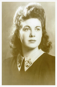
Document - The Reynolds Family Records Collection (Folder 1 of 4) - Hector Baden Reynolds, his daughter June Amelia Reynolds (Born 1925), Abt 2005
... ...robert reynolds...She sold poultry and eggs and preserves. bendigo sandhurst peter jorgensen eleanor hinde eleanor reynolds eleanor opie reynolds collection amelia honorah reynolds charles frank greenaway charles albion reynolds iris ellen greenaway william donald male ruth honora greenaway dirk pendavingh percy george tobias louisa catherine reynolds lois noelle tobias lois mitchell lois tobias robert reynolds hector baden reynolds june amelia reynolds desmond lloyd The four folders contain family history documents and photos of the descendants of Eleanor Hinde. ...Eleanor Hinde (1842-1902) was born in Lancashire England. In 1858, Eleanor married Richard Reynolds in the Forest Street Wesleyan Methodist Church in Sandhurst. They both gave their address as Sailors Gully Goldfields. They had seven children together. Richard was a skilled tradesman and after he died in 1872 from lung disease, Eleanor married Arculus Opie. Eleanor owned a property on the corner of Gladstone and Stanley Streets which later became an electrical substation. She sold poultry and eggs and preserves. The four folders contain family history documents and photos of the descendants of Eleanor Hinde. June Amelia Reynolds is the Great Grand-daughter of Richard Reynolds and Eleanor Hinde. This item includes the following documents: 10891.11a Family History Sheet of June Amelia Reynolds 10891.11b Thank you card from June to Ruth Greenway 10891.11c June Amelia Reynolds 10891.11d Des and June Lloyd (nee Reynolds) St Patricks Cathedral Melbourne 15/2/1947 10891.11e Eulogy Front Page for Desmond Lloyd 13 October - 29 May 2005 10891.11f Eulogy Rear Page for Desmond Lloyd 13 October - 29 May 2005 10891.11g to 10891.ag (29 Items) Family history sheets, articles, and photos for Descendants of June Reynolds - contact the Bendigo Historical Society for detailsbendigo, sandhurst, peter jorgensen, eleanor hinde, eleanor reynolds, eleanor opie, reynolds collection, amelia honorah reynolds, charles frank greenaway, charles albion reynolds, iris ellen greenaway, william donald male, ruth honora greenaway, dirk pendavingh, percy george tobias, louisa catherine reynolds, lois noelle tobias, lois mitchell, lois tobias, robert reynolds, hector baden reynolds, june amelia reynolds, desmond lloyd -
 Bendigo Historical Society Inc.
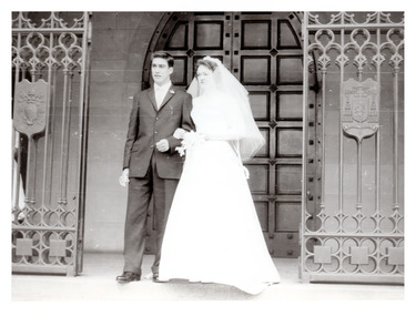
Document - The Reynolds Family Records Collection (Folder 1 of 4) - Hector Baden Reynolds, his son Rex Charles Reynolds, Abt 2005
... ...robert reynolds...She sold poultry and eggs and preserves. bendigo sandhurst peter jorgensen eleanor hinde eleanor reynolds eleanor opie reynolds collection amelia honorah reynolds charles frank greenaway charles albion reynolds iris ellen greenaway william donald male ruth honora greenaway dirk pendavingh percy george tobias louisa catherine reynolds lois noelle tobias lois mitchell lois tobias robert reynolds hector baden reynolds june amelia reynolds desmond lloyd rex charles reynolds marie therese ryan The four folders contain family history documents and photos of the descendants of Eleanor Hinde. ...Eleanor Hinde (1842-1902) was born in Lancashire England. In 1858, Eleanor married Richard Reynolds in the Forest Street Wesleyan Methodist Church in Sandhurst. They both gave their address as Sailors Gully Goldfields. They had seven children together. Richard was a skilled tradesman and after he died in 1872 from lung disease, Eleanor married Arculus Opie. Eleanor owned a property on the corner of Gladstone and Stanley Streets which later became an electrical substation. She sold poultry and eggs and preserves. The four folders contain family history documents and photos of the descendants of Eleanor Hinde. Rex Charles Reynolds (1936-1993) is the Great Grand-son of Richard Reynolds and Eleanor Hinde. This item includes the following documents: 10891.12a Family History Sheet of Rex Charles Reynolds and Marie Therese Ryan 10891.12b Wedding photo or Rex and Marie 10891.12c to d Two items on descendants of Rex and Marie - contact the Historical Society for details.bendigo, sandhurst, peter jorgensen, eleanor hinde, eleanor reynolds, eleanor opie, reynolds collection, amelia honorah reynolds, charles frank greenaway, charles albion reynolds, iris ellen greenaway, william donald male, ruth honora greenaway, dirk pendavingh, percy george tobias, louisa catherine reynolds, lois noelle tobias, lois mitchell, lois tobias, robert reynolds, hector baden reynolds, june amelia reynolds, desmond lloyd, rex charles reynolds marie therese ryan -
 Whitehorse Historical Society Inc.
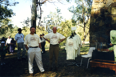
Photograph, Open Day 1998, 1/04/1998
... robert...reynolds...Whitehorse Historical Society Inc. 2-10 Deep Creek Road Mitcham melbourne nunawading and district historical society heritage week 1998 smith robert reynolds bruce Coloured photo of Society Members wearing T - Shirt displaying Society's Logo at Heritage Week Open Day 1998. ...Coloured photo of Society Members wearing T - Shirt displaying Society's Logo at Heritage Week Open Day 1998.nunawading and district historical society, heritage week 1998, smith, robert, reynolds, bruce -
 Geoffrey Kaye Museum of Anaesthetic History
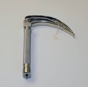
Tool - Laryngoscope, Macintosh
... macintosh, robert reynolds...Mainland became a Fellow of the Australian and New Zealand College of Anaesthetists in 1992, retiring from the profession in 1997. macintosh, robert reynolds new zealand laryngoscope Mainland, John Alfred hospital Moon landing Etched into top of handle: J.F. ...A laryngoscope is an instrument used to view the larynx (voice box), which is the opening to the trachea and lungs. It consists of a “blade,” which goes into the patient’s mouth, and a handle. Prior to 1943 when Macintosh introduced his curved blade, most laryngoscope blades were long and straight. The straight blades were used to directly hold the epiglottis. Macintosh’s curved blade works differently: it indirectly opens the epiglottis by applying pressure to a space between the root of the tongue and epiglottis, called the vallecula. The flange running along the left lower edge of Macintosh’s blade was also a novel innovation. It was designed to move the tongue to the side, which improved the view of the larynx and made more room for a breathing tube. The Macintosh Laryngoscope remains one of the most popular blades worldwide. (Source: Wood Library Museum) This laryngoscope was previously owned by John Mainland, as evidenced by the name etched into the handle. Mainland graduated from the University of Melbourne in 1950 with a Bachelor of Science degree. After researching and completing his medical degree, Mainland entered into the field of anaesthetics, training at the Royal Women's and Royal Children's Hospitals, later Alfred Hospital, in 1959. He completed training in 1964 and remained at the Alfred Hospital. During his career, he also became the first anaesthetist appointed to the position of Professor in Victoria. His other achievements include manufacturing a respiratory monitoring module that accompanied astronauts on the United States moon landing and developing a stimulator to lessen the risk of deep vein thrombosis in surgical patients. Mainland became a Fellow of the Australian and New Zealand College of Anaesthetists in 1992, retiring from the profession in 1997.Oblong shaped handle with textured grip. Attached is a laryngoscope blade in a cruved shaped with light tube running through one side.Etched into top of handle: J.F. MAINLAND •Stamped into top of handle: REGD TRADE MARK / PENLON / MADE IN ENGLAND •Stamped into base of handle: CLOSE [arrow] •Etched into base of blade: MAC / 4 •Stamped into side of blade: REGD TRADE MARK / PENLON / MADE IN ENGLAND •Stamped into side of blade: STAINLESSmacintosh, robert reynolds, new zealand, laryngoscope, mainland, john, alfred hospital, moon landing -
 Glen Eira Historical Society
Letter - St Pauls Anglican Church, 530 Dandenong Road, Caulfield North
... Robert... Barberis Irene... Reynolds...Artists Akins Robert Barberis Irene Reynolds Chris Wolstencroft Ivor Gully/Moore Alison Moore Peter Engineers Kovacs Joseph Architects Vicars-Foote Bequest Dorothy Hallock Shanta Newman Philip Molineux John Stained glass Molineux Kim Moorhouse Philip O'Farrell Gavan Smith Beverley Rev. ...Ring out Wild Bells!', an all-encompassing history of St Pauls Anglican Church from 1904 – 2004 by Southern cross ministries.com.au. The book takes in all aspects of the church’s ministry, from acquiring the first building, church festivals, Dramatic Club, Social dances, Annual fetes, tennis club, St Pauls Preparatory School; Darish Heros, the 16 memorial stained glass windows, St Pauls dance group, Home group, the healing team, St Pauls Juvenile Orchestra and womens guilds. Correspondence to Claire Barton, dated 29/04/2010 from Cynthia Nyholm, with enclosed book – Ring out Wild Bells the centenary book for St Pauls Anglican Church; Caulfield North 2004.st paul’s anglican church, lynch frank rev., nyholm cynthia, falkingham john canon, north caulfield, ivens george walter dr., kircher godfre rev., saunders harriet eleanor (nelly), wilson albert rev., thewlis brian rev., saunder elizabeth (topsy), meredith charles rev., rutherford. graeme rev., arnold leonard rev, drought john rev., hannaford. john rev., rich roger rev., grully/moore alison, charles oliver, bell towers, clarke henry lowther, roberts frank, ngaruk william, boon wurrung, aboriginal peoples, the black chapel, hawthorn road, balaclava road, glen eira road, taylor rev., seddon rev., edith street, park street, st. mary's parish, shelley edgar, ellerslie, roe thomas, salisbury street, st. elmo's community, mccartney hugh, herring nigel, robinson john, mollinson a.j., derby parade, vance george, statham rev., priest rev., cox rev., queen's hall caulfield, jolly edith, evans jan, societal event and activities, clubs and associations, sporting clubs, cohen leslie, cohen doris, 'anselm', manses, wilson albert mrs, wainwright emily, ivens eleanor, roberts frank, falkenstein lynaire, dove bill, lawn david, edwards peter, jenkins barry, backhouse gerald, triller henrietta, monahan marjorie, wainright bill, 'yanga', alma road, dandenong road, fitzwater mr, lovell house girls school, st paul's preparatory school, independent schools, kindergartens, hoggart mrs, jackson miss, davidson bob, hutchens bernard, meredith benjamin, mannett david, hutchins harry, vicars, foote sheila, scholes lillian, mee elroy, driver marjorie, manton betty, bottomley hilda, west joan, finn grace, dell hazel, guild of the holy spirit, carrigan john rev., allen douglas, thompson norman, hardy don, moroney john, scott-simmons harry, morphet george, houghton robert, drought tom, stringer alf, miller eddie, michie bill, roberts david, hardy bill, cohen vernon, cohen leon, thewlis jeremy, tanner simon, lambert luke, wainwright bill, wilson albert, meredith charles, williams louis r., architects, dawson and smith, builders, monuments and memorials, st. paul apostle and martyr, red hill, ackland a.l., drought peter, kircher virginia, martinu ignaz, metal working, crafts and craft equipment, mathieson w., stained glass, morgan kerr w., cohen ursula, french anne maree, stephens evelyn, roberts janet, tanner john, oliphant alison, oliphant david, drought alison, widdowson charles rev., rich regina, fettel rex, amson evan, amson angela, stonehouse elwyn, thewlis elsbeth, cranswick jim, byrne meredith, jackson jill, jackson family, fitzgerald anne, molineux john, pilkington merridee, wood noel, major paula, major tracy, kaines fiona, west ed, nelson jenny, booth anne, pental road, carnarvon road, daynes alysa, tanner john, tanner winkie, jackson les, thornton graham, thornton gwyn, drought gladys, mcgillivery joan, glennen jim canon, wood maureen, wood david boyle, wood felicity, corrie ian, corrie lesley, sharrock heidi, sharrock lynette, sharrock david, rutherford david, samuel anto (hilda), hannaford john, palliar bob, golden hope healing sanctuary, hostels, moore alison, johnson wendy, stringer barbara, carson penny, edwards joan, glen eira intercessary group, smith beverly, daynes aylsa, lyon tryphena, fitzgerald anne, de bibra (peggy) margaret, de bibra florence, singleton george, darke guy, thompson norman, hutchinson jay, lawry margaret, woddy julie, mcgrath lesley, amson angela, prashanthi samuel, mclean rob, st. elmo's fire alpha in victoria, kainey john, kainey dick rev., amson evan, hannaford janine, hannaford john rev., playgrounds, shinkfield thelma, west joan, staham clive, batey mandy, walker david rev., stokes tom rev., batey david, freeman lesley, social services, pittaway geoff, jones greg, turf club hotel, the angel, conway carolyn, razmaran (raz) rameen, moore peter, thewlis sharon, walker stephen, turuwhenva jo maka maka, redman dylan, jolly david, toombs nicole, hannaford/akins christy, akins ben, edwards rozanne, masson andrew, batey kyle, batey ailsa, kovars aranka, graffiti, mcallister alison, buchanen noel, cocks damien, holland m.w., artists, akins robert, barberis irene, reynolds chris, wolstencroft ivor, gully/moore alison, moore peter, engineers, kovacs joseph, architects, vicars-foote bequest dorothy, hallock shanta, newman philip, molineux john, stained glass, molineux kim, moorhouse philip, o'farrell gavan, smith beverley rev., peppercorn miss, corrigan mrs, choirs, thomas ronald, geo fincham and sons, wicks mr, mcgillivery alf, organs, mcgillivery ian, touzeau mme, triller lily, lawrence jean, falkingham john, bonsal/boone peter, tweeddale alistair, worsnop paul, stonehouse pam, rutherford graeme, rutherford caroline, braun doug, naughton celia, correll madge, edwards joan, paranavitana darshini, gebert barb, wood felicity, cowell alison, mannaford lawson, ellankoon robby, knight sheila, thornton graeme, kyle estelle, davies john, roberts frank, welch ian, de saint-ferjeux, francis peggy, gill heather, lambert dale, newing joyce, young rosemary, mcallister (pownell/washington), roeland linda, mcdonald brendan, lewis irene, lewis graham, fitzgerald anne, hoffman tim, kaines fiona, marriott dianne, stryk angela, leaf narelle, choo lucy, fitzgerald narelle, nunis mark, waterman roma, beggs joshua, cramer deb, beggs camilla, gebert kelvin, oakes joanne, sargeant john, schulz wendy, smith lerisse, austin adrian, mitchell stephanie, oakes jessica, cropley stan, banks caroline, banks peter, chen caroline, west rob, chen family, mcgough virginia (now mcdonald_, fin tania, stonehouse elwyn, ryan luisa, knight sheila, savage ian rev., kircher jillian, kircher pamela, kircher margaret, bernaldo darryl, rich cassandra, rich leighton, james scott, correll madge (nee gamble), correll tony, o'brien maureen, rodwell kevin, de vries isabella, de vries andre, de vries darren, cummins mr, roberts mr, de vries ngaio (nee morre), wainright emily, wainright william, massauelli lionel, roberts frank, foster muriel, thomas janet, laycock gordon, shiel john, langmuir keith, langford alan, burns jack, manson ian, manton john, mclean robert, lund milton, carr sylvia, ross margie, naughton michael, edwards joan, chappele ethel, chappele marion, pollard mrs, moorhouse michelle, shipp joyce, hayman jean, bright-parker kath, stringer thelma, armstrong wendy, martin neil, stonehouse janet, eddy elsie, gras elsie, macartney kitty, ormond special school (katandra), herring nigel, roe sisters, watson w.g., nicholls w., beith harley, cullen phyllis, burns leline, hayman eric, boyd-jones ennys, roberts frank, ellankoon chrissie, blommestein michael, ahn sil -
Federation University Historical Collection
Booklet, J.A. Hoskin & Son, Ballarat School of Mines Students' Magazine, 1945, 1945
... ...lois reynolds...robert...Barker Library (top floor) Mount Helen goldfields List of Full Course Students' 1945, Editorial, Editor's Notes, News and Notes, End of the War 1939-1945, Obituary, The Literary Society, The Chemical Nature of Women, Fumes from the Lab, Forests - Our Asset and Responsibility, Arts & Crafts Gossip, Sports, Commercial Notes, The Junior Techs ballarat school of mines magazine g. curtis p. edmonds kevin j. whiter david t. coburn peter j. wilson john k. leicht douglas d.g. dean frank d. daykin grace lawry p. maloney j. mckenzie percival d. fisher stanley s. parker beatrice e. burgess roy e. mawby roma sudoltz peter h. marxsen lois reynolds robert j. mckenzie w. coad marion a. beckwith john g. procter gweneth. speirs neville f. reeve dr pound c. fairbank f. g. procter jeanette perkins john w. jolly m. berlyn c. g. fairbank bill f. carroll marjorie gray f. n. reeve joan waller winifred m. beckwith isobel murfett frank daykin joy martin max coward jack henderson joe wilkinson alan wilson muriel harland m. fogarty sylvia williams t. r. thomas john p. l. gibbs t. mccartney a. s. richards p. crosby h. middlin mr cornell lois kinnersley margaret murrell ouida worthington i. murfett ruby gladman john m. blainey mina gallie miss darby p. moloney v. eva lester w. roffey robert f. swales john e. ambrosio mr hillman neville r. morton basil j. marshall lloyd lehmann lindsay s. pattenden john middlin alfred e. temby a. hyett willaim g. young kingsley r. bremmer william j. hewitt geoffrey f. stevens n. black lucy cooper valma overall evelyn ditchfield b. lancaster miriam horsey lorraine saunders n. hoffman audrey fry robert j. murell colin a. bell ewan c. jones d. powell william j. llewllyn kenneth s. lindsay nola dridan patricia gleeson winifred stevens mary cummins b. sherritt alison johnson b. conway b. vallins k. dowall m. grinham k. eberhard c. lea k. george a. coad c. eltringham w. allan m. silvey f. jacobson l. clifton r. sargent w. caldow g. pyke g. bergin k. dean r. bennett k. hoffman a. kerr h. sealey d. mcconville p. nunn d. halson l. frichot g. smith m. mcdonald w. hon r. irving l. drake c. gedye g. jukes a. new a. smith k. weybury c. wilson p. banfield a. hughes g. yeoman eda woodfield francis duffy Maroon cover with, blue, green and gold lettering, soft covered magazine of 72 pages including advertisements. ...List of Full Course Students' 1945, Editorial, Editor's Notes, News and Notes, End of the War 1939-1945, Obituary, The Literary Society, The Chemical Nature of Women, Fumes from the Lab, Forests - Our Asset and Responsibility, Arts & Crafts Gossip, Sports, Commercial Notes, The Junior TechsMaroon cover with, blue, green and gold lettering, soft covered magazine of 72 pages including advertisements. Artwork Mr Calder - By Eda Woodfield Miss Williams - By Ruth Mole Basil - By Beatrice Burgess Roy - By Eda Woodfield Mac - By Gweneth Speirs Joll - By Marjorie Gray Doug - By Ruth Mole View from the cutters hut - By Marion Beckwith Mr Fairbank - By Ruth Mole Perc - By Ruth Mole Peter - By Eda Woodfield Fritz - By Joan Walter On the track to the cutter's hut - By Joan Walter The cutter's hut - By Ruth Mole Gertie - By Marjorie Gray Bombhead - By Ruth Mole Gwen - By Francis Duffy Marje - By Ruth Mole David - By Joan Walter Skeeter - By Joan Walter Ewan - By Ruth Mole Blue - By Neville Reeve Stanley - By Joan Walter George - By Joan Walter Vic - By Beatrice Burgess Gladys - By Eda Woodfield Olwyn - By Beatrice Burgess Valda - By Beatrice Burgess Betty - By Eda Woodfield June - By Eda Woodfield Stella - By Beatrice Burgess Verna - By Eda Woodfield Valerie - By Eda Woodfield June - By Beatrice Burgess Dorothy - By Joan Walter Beryl - By Joan Walter Noreen - By Ruth Mole Pat - By Joan Walter Valma - By Eda Woodfield Graham - By Gweneth Speirs Johnny - By Joan Walter Charlie - By Beatrice Burgess Raynor - By Marjorie Gray George - By Marjorie Gray Darkie - By Ruth Mole Duck - By Beatrice Burgess Robert - By Ruth Mole William - By Gweneth Speirs Basil - By Joan Walter Wilson - By Joan Walter Schoolbeck - By Ruth Mole Duck Weed - By Eda Woodfield Bas - By Beatrice Burgess Albert - By Ruth Mole ballarat school of mines, magazine, g. curtis, p. edmonds, kevin j. whiter, david t. coburn, peter j. wilson, john k. leicht, douglas d.g. dean, frank d. daykin, grace lawry, p. maloney, j. mckenzie, percival d. fisher, stanley s. parker, beatrice e. burgess, roy e. mawby, roma sudoltz, peter h. marxsen, lois reynolds, robert j. mckenzie, w. coad, marion a. beckwith, john g. procter, gweneth. speirs, neville f. reeve, dr pound, c. fairbank, f. g. procter, jeanette perkins, john w. jolly, m. berlyn, c. g. fairbank, bill f. carroll, marjorie gray, f. n. reeve, joan waller, winifred m. beckwith, isobel murfett, frank daykin, joy martin, max coward, jack henderson, joe wilkinson, alan wilson, muriel harland, m. fogarty, sylvia williams, t. r. thomas, john p. l. gibbs, t. mccartney, a. s. richards, p. crosby, h. middlin, mr cornell, lois kinnersley, margaret murrell, ouida worthington, i. murfett, ruby gladman, john m. blainey, mina gallie, miss darby, p. moloney, v. eva, lester w. roffey, robert f. swales, john e. ambrosio, mr hillman, neville r. morton, basil j. marshall, lloyd lehmann, lindsay s. pattenden, john middlin, alfred e. temby, a. hyett, willaim g. young, kingsley r. bremmer, william j. hewitt, geoffrey f. stevens, n. black, lucy cooper, valma overall, evelyn ditchfield, b. lancaster, miriam horsey, lorraine saunders, n. hoffman, audrey fry, robert j. murell, colin a. bell, ewan c. jones, d. powell, william j. llewllyn, kenneth s. lindsay, nola dridan, patricia gleeson, winifred stevens, mary cummins, b. sherritt, alison johnson, b. conway, b. vallins, k. dowall, m. grinham, k. eberhard, c. lea, k. george, a. coad, c. eltringham, w. allan, m. silvey, f. jacobson, l. clifton, r. sargent, w. caldow, g. pyke, g. bergin, k. dean, r. bennett, k. hoffman, a. kerr, h. sealey, d. mcconville, p. nunn, d. halson, l. frichot, g. smith, m. mcdonald, w. hon, r. irving, l. drake, c. gedye, g. jukes, a. new, a. smith, k. weybury, c. wilson, p. banfield, a. hughes, g. yeoman, eda woodfield, francis duffy -
 Bendigo Historical Society Inc.
Document - The Reynolds Family Records Collection (Large portraits and four folders), Abt 1900
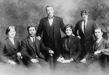
... The four folders contain family history documents and photos of the descendants of Eleanor Hinde, plus five large family black and white portraits This item contains the portraits: 11132.1a Robert Reynolds 11132.1b Family of Charles and Ellen Reynolds (presumed sitting 2nd and 3rd from the left), about 1915, with their family, Amelia, Robert, Louisa and Hector. 11132.1c Amelia Reynolds 11132.1d Maybe Ellen Reynolds 11132.1e Unknown...He left Denmark in the year 1861, embarking at Hamburg in a small sailing Ship. bendigo sandhurst peter jorgensen eleanor hinde eleanor reynolds eleanor opie reynolds collection The four folders contain family history documents and photos of the descendants of Eleanor Hinde, plus five large family black and white portraits This item contains the portraits: 11132.1a Robert Reynolds 11132.1b Family of Charles and Ellen Reynolds (presumed sitting 2nd and 3rd from the left), about 1915, with their family, Amelia, Robert, Louisa and Hector. 11132.1c Amelia Reynolds 11132.1d Maybe Ellen Reynolds 11132.1e Unknown Document The Reynolds Family Records Collection (Large portraits and four folders) ...Eleanor Hinde (1842-1902) was born in Lancashire England. In 1858, Eleanor married Richard Reynold in the Forest St Wesleyn Methodist Church in Sandhurst. They both gave their address as Sailors Gully Goldfields. They had seven children together. Richard was a skilled tradesman and after he died in 1872 from lung disease, Eleanor married Arculus Opie. Eleanor owned a property on the corner of Gladstone and Stanley Streets which later became an electrical substation. She sold poultry and eggs and preserves. One of Eleanor's sons, William John, married Anna (Annie) Jorgensen, and one of her daughters. Amelia, married Anna's brother Thomas Joynes Jorgensen. The Jorgensens founded and managed Jorgensen and Sons foundry and engineering works. Peter Jorgensen (1849-1914), was a mining contractor, he lived at, "Bro," Russell street, Quarry Hill. His firm was Jorgensen and Sons, mining contractors. He was a native of the Island of Alsen, Denmark. He left Denmark in the year 1861, embarking at Hamburg in a small sailing Ship. The four folders contain family history documents and photos of the descendants of Eleanor Hinde, plus five large family black and white portraits This item contains the portraits: 11132.1a Robert Reynolds 11132.1b Family of Charles and Ellen Reynolds (presumed sitting 2nd and 3rd from the left), about 1915, with their family, Amelia, Robert, Louisa and Hector. 11132.1c Amelia Reynolds 11132.1d Maybe Ellen Reynolds 11132.1e Unknownbendigo, sandhurst, peter jorgensen, eleanor hinde, eleanor reynolds, eleanor opie, reynolds collection -
 Carlton Football Club
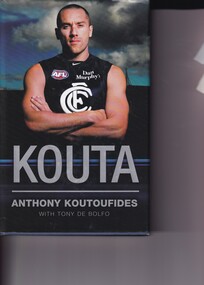
Hardcover Book, Kouta, 1/11/07
... Adelaide, at Princes Park Height 191 cm (6 ft 3 in) Weight 100 kg (220 lb) Years Club Games (Goals) 1992–2007 Carlton 278 (226) Career highlights Leigh Matthews Trophy (AFLPA MVP): 2000 Robert Reynolds Trophy: 2001, 2005 All Australian: 1995, 2000 Carlton Captain: 2004–2006 Carlton Leading Goalkicker: 1997 Carlton premiership team: 1995 AFL and Carlton life-member Victorian State of Origin: 1999 Australian Football Hall of Fame inductee 2014 Greek Team of the Century: Vice-Captain VFL/AFL Italian Team of the Century: Centre Half-Back...Adelaide, at Princes Park Height 191 cm (6 ft 3 in) Weight 100 kg (220 lb) Years Club Games (Goals) 1992–2007 Carlton 278 (226) Career highlights Leigh Matthews Trophy (AFLPA MVP): 2000 Robert Reynolds Trophy: 2001, 2005 All Australian: 1995, 2000 Carlton Captain: 2004–2006 Carlton Leading Goalkicker: 1997 Carlton premiership team: 1995 AFL and Carlton life-member Victorian State of Origin: 1999 Australian Football Hall of Fame inductee 2014 Greek Team of the Century: Vice-Captain VFL/AFL Italian Team of the Century: Centre Half-Back Book outlining Career & Life of one of Carlton's most popular & gifted players. ...Anthony Koutoufides - Biography/Autobiography Date of birth 18 January 1973 (age 46) Original team(s) Lalor Debut Round 13, 1992, Carlton vs. Adelaide, at Princes Park Height 191 cm (6 ft 3 in) Weight 100 kg (220 lb) Years Club Games (Goals) 1992–2007 Carlton 278 (226) Career highlights Leigh Matthews Trophy (AFLPA MVP): 2000 Robert Reynolds Trophy: 2001, 2005 All Australian: 1995, 2000 Carlton Captain: 2004–2006 Carlton Leading Goalkicker: 1997 Carlton premiership team: 1995 AFL and Carlton life-member Victorian State of Origin: 1999 Australian Football Hall of Fame inductee 2014 Greek Team of the Century: Vice-Captain VFL/AFL Italian Team of the Century: Centre Half-BackBook outlining Career & Life of one of Carlton's most popular & gifted players. Kouta was a match winner whose career was curtailed by injury. Kouta's most famous game was Carlton's 1 point win over Essendon 1999 Prelim Final -
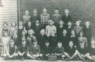 Ringwood and District Historical Society
Photograph, Ringwood State School - Grade 5, 1945
... "Attached to photograph" Back Row - L to R: Robert Mathieson, ?, Ken Reynolds, Glen Hubbard, ?. 2nd Row - L to R: ?...Ringwood and District Historical Society 125A Warrandyte Road Ringwood North melbourne "Attached to photograph" Back Row - L to R: Robert Mathieson, ?, Ken Reynolds, Glen Hubbard, ?. 2nd Row - L to R: ? ...Black and white photograph - Grade 5,1945."Attached to photograph" Back Row - L to R: Robert Mathieson, ?, Ken Reynolds, Glen Hubbard, ?. 2nd Row - L to R: ?, ?, Margaret Burns, ?, ?, Muriel Upstill, ?, ?, ?, ?. 3rd Row - L to R: May Burton, ?, ?, ?, ?, ?, ?, ?, Jeanette Burnside. Front Row - L to R: Ian Lynton, Neil Dark, ?, ?, ?, ?, ?, Barry Young. Teacher: -
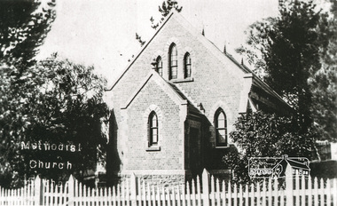 Eltham District Historical Society Inc
Photograph, Tom Prior, Methodist Church, Eltham
... Formerly Wesleyan, Methodist then Uniting church; the foundations of the church building were constructed with stone from the walls of the first Eltham State Primary School (No. 209) building which collapsed in 1874 and were purchased by Robert David Taylor. The Reynolds/Prior Photograph Collection, Presented to the Eltham District Historical Society, 14 June 2006 by Ross McDonald. ...Formerly Wesleyan, Methodist then Uniting church; the foundations of the church building were constructed with stone from the walls of the first Eltham State Primary School (No. 209) building which collapsed in 1874 and were purchased by Robert David Taylor. The Reynolds/Prior Photograph Collection, Presented to the Eltham District Historical Society, 14 June 2006 by Ross McDonald. ...Situated at 810 Main Road on the corner of John Street. The Church was surrounded by a picket fence and tall pine trees. The Church was built by George Stebbings in the 1850s and is an example of fine craftmanship. Formerly Wesleyan, Methodist then Uniting church; the foundations of the church building were constructed with stone from the walls of the first Eltham State Primary School (No. 209) building which collapsed in 1874 and were purchased by Robert David Taylor. The Reynolds/Prior Photograph Collection, Presented to the Eltham District Historical Society, 14 June 2006 by Ross McDonald. A second copy was also presented to the Andrew Ross Museum, Kangaroo Ground The Reynolds family were early settlers in Research. Reynolds Road is named after this family. RERVISED STATEMENT OF SIGNIFICANCE, CONTEXT, 2010 What is significant? The 1880 bichromatic brick church and the surrounding site to the title boundaries. The church is architecturally, historically, socially and spiritually significant to the Shire of Nillumbik. Why is it significant? The church is architecturally significant as a finely detailed example of a brick 19th century rural community church, one of only four in the Shire (Criteria E & B). The church is historically significant as an important link with the time when Eltham was a small, insular country settlement. Also for the historical evolution visible in the complex, with the modest 1880s church and larger red brick rear hall from the early 20th century as a reflection of population growth in the area (Criterion A). The church is historically, spiritually and socially significant because it has played, and continues to play, an important part in the spiritual and social life of the community (Criterion G). - Victorian Heritage Database The Reynolds family were early settlers in Research. The Reynolds/ Prior collection of photographs were taken by Tom Prior, the maternal uncle of Ivy Reynolds, around 1900 and the 60 photos in the album give a fine overview of many of the landmarks of Research and Eltham over 100 years ago. lvy lived in the family home for many years at 106 Thompson Cres Research. Ivy's father, Ernst Richard Reynolds and grandfather, Richard Reynolds, lived at the same address. Ivy's father Richard worked for Mr. Trail on his property in Research. Reynolds Road is named after the family. Mr Tom Prior (wife Eva) worked at the Melbourne zoo. He was very innovative and made his own camera, using the black cloth hood to exclude the light. The photographs are a reminder of the rural nature of Research and Eltham and its rich heritage. Black and white photograph mounted in an album, the Reynolds/Prior Photograph Collection, this being one of 53 reproduced black and white images of early Eltham."Methodist Church" reynolds prior collection, eltham, methodist church -
 Sunshine and District Historical Society Incorporated
Photograph - Albion State School 2004 Class Photographs
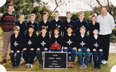
... 5157.01 - Albion State School 2004 Staff 5157.01 - Albion State School 2004 Staff Names and Individuals Top Row L2R Elissa Barr Betty Batty Lorraine Farrugia Donna George Wayne Haren Second Row L2R Julie Hrovatin Ngare Knight Third Row L2R Lyn Mahoney Gillian McGillivray David Moss Andrea Murray Lorraine Parnis Front Row L2R Jan Van Beerendonk Jann Turner Mary Talbot Sandra Spurr Angela Paschalidiws 5157.02 - Albion State School 2004 School Leaders 5157.03 - Albion State School 2004 Grade Prep B 5157.03 - Albion State School 2004 Grade Prep B Names and Individuals Back Row L2R Elissa Barr Tristan Adams Dejan Ajder Adam Carter Craig Coburn Adrian Czopowski Brianna Doggett Second Row L2R Georgia Doslov Seth Duggan Third Row L2R Nathaniel Ioannou Andy Khong Madelyne Markovic Leigh Marsden Cristina Mendoza Jack Mooney Front Row L2R Melissa Petras Joyce Protacio Jordan Raye Chad Smith Tonga Tuaimeiuta Rachael Zerni Absent Harlee Graham 5157.04 - Albion State School 2004 Grade 5 6T Names and Individuals Back Row L2R Mary Talbot Peter Anthony Mayne Chantel Attard Amy Caruana Smith Kasey Davis Samantha Firth Second Row L2R Jessica Heeps Ladd John Third Row L2R Annie Lam Shakira Lever Corine Markovic Julie Rand Jake Raye Nivaar Rolston Front Row L2R Carl Schwencke Mitchell Tiffany Smith Alicia Stankus Callan Tishler Danielle Williams Jennifer Williams Absent Merren Smart 5157.05 - Albion State School 2004 Grade 5 6H Names and Individuals Front Row L2R Wayne Haren William Burrows Crystal Carter Imran Clancy Melissa Hall Samantha Hastings Jesse Hearn Second Row L2R David Kennedy Chantelle Langanke Third Row L2R Jenny Le Teagan Maguire Cody Mayne Michael Nardella Rahma Nurhussien Timothy ONeill Robert Reynolds Back Row L2R James schwencke Mitchell Danielle Tarroza Thuy Tran Jennifer Truong Malgorzata Wasilewska Nicole Williams Absent Nargis Thakur 5157.06 - Albion State School 2004 Grade 3 4T 5157.06 - Albion State School 2004 Grade 3 4T Names and Individuals Front Row L2R Jann Turner Milorad Aider Kieran Azzopardi Nicholas Burrows Natalie Coburn Jesse Culhane Saamu Luke DAlfonso Second Row L2R Meghan Douglas Ashleigh Gauci Third Row L2R Melisa Husejnovic Alfred Kennedy Kobi Marsden Reece Mayne Annalise McMillan Joshua Micallef John Milan Back Row L2R Jayde Page Narrell Raye Nicole Reynolds Bethany Tippet David Tran David Ung Ebony Wemyss Absent Joshua Cancino 5157.07 - Albion State School 2004 Grade 3 4M 5157.07 - Albion State School 2004 Grade 3 4M Names and Individuals Front Row L2R Gillian McGillivray Suerour Abdul Alrahman Jessica Bretherton Benjamin Britton Malea Culhane Saamu Hayden Formosa Second Row L2R Emilia Gruescu Joshua Kanongataa Third Row L2R Chelsea Lever Aaron Mayne Orlando Mayor Travis Montague Jim Murphy Christene Protacio Back Row L2R Jack Schofield Jessica Tawaf David Truong Naomi Truong Julie Ung Milos Zarkovic Absent Joshua Boudoloh Shaian Luke ...Albion State School Albion Primary School Adelaide Street Albion 5157.01 - Albion State School 2004 Staff 5157.01 - Albion State School 2004 Staff Names and Individuals Top Row L2R Elissa Barr Betty Batty Lorraine Farrugia Donna George Wayne Haren Second Row L2R Julie Hrovatin Ngare Knight Third Row L2R Lyn Mahoney Gillian McGillivray David Moss Andrea Murray Lorraine Parnis Front Row L2R Jan Van Beerendonk Jann Turner Mary Talbot Sandra Spurr Angela Paschalidiws 5157.02 - Albion State School 2004 School Leaders 5157.03 - Albion State School 2004 Grade Prep B 5157.03 - Albion State School 2004 Grade Prep B Names and Individuals Back Row L2R Elissa Barr Tristan Adams Dejan Ajder Adam Carter Craig Coburn Adrian Czopowski Brianna Doggett Second Row L2R Georgia Doslov Seth Duggan Third Row L2R Nathaniel Ioannou Andy Khong Madelyne Markovic Leigh Marsden Cristina Mendoza Jack Mooney Front Row L2R Melissa Petras Joyce Protacio Jordan Raye Chad Smith Tonga Tuaimeiuta Rachael Zerni Absent Harlee Graham 5157.04 - Albion State School 2004 Grade 5 6T Names and Individuals Back Row L2R Mary Talbot Peter Anthony Mayne Chantel Attard Amy Caruana Smith Kasey Davis Samantha Firth Second Row L2R Jessica Heeps Ladd John Third Row L2R Annie Lam Shakira Lever Corine Markovic Julie Rand Jake Raye Nivaar Rolston Front Row L2R Carl Schwencke Mitchell Tiffany Smith Alicia Stankus Callan Tishler Danielle Williams Jennifer Williams Absent Merren Smart 5157.05 - Albion State School 2004 Grade 5 6H Names and Individuals Front Row L2R Wayne Haren William Burrows Crystal Carter Imran Clancy Melissa Hall Samantha Hastings Jesse Hearn Second Row L2R David Kennedy Chantelle Langanke Third Row L2R Jenny Le Teagan Maguire Cody Mayne Michael Nardella Rahma Nurhussien Timothy ONeill Robert Reynolds Back Row L2R James schwencke Mitchell Danielle Tarroza Thuy Tran Jennifer Truong Malgorzata Wasilewska Nicole Williams Absent Nargis Thakur 5157.06 - Albion State School 2004 Grade 3 4T 5157.06 - Albion State School 2004 Grade 3 4T Names and Individuals Front Row L2R Jann Turner Milorad Aider Kieran Azzopardi Nicholas Burrows Natalie Coburn Jesse Culhane Saamu Luke DAlfonso Second Row L2R Meghan Douglas Ashleigh Gauci Third Row L2R Melisa Husejnovic Alfred Kennedy Kobi Marsden Reece Mayne Annalise McMillan Joshua Micallef John Milan Back Row L2R Jayde Page Narrell Raye Nicole Reynolds Bethany Tippet David Tran David Ung Ebony Wemyss Absent Joshua Cancino 5157.07 - Albion State School 2004 Grade 3 4M 5157.07 - Albion State School 2004 Grade 3 4M Names and Individuals Front Row L2R Gillian McGillivray Suerour Abdul Alrahman Jessica Bretherton Benjamin Britton Malea Culhane Saamu Hayden Formosa Second Row L2R Emilia Gruescu Joshua Kanongataa Third Row L2R Chelsea Lever Aaron Mayne Orlando Mayor Travis Montague Jim Murphy Christene Protacio Back Row L2R Jack Schofield Jessica Tawaf David Truong Naomi Truong Julie Ung Milos Zarkovic Absent Joshua Boudoloh Shaian Luke Collection of Digital Photographs Photograph Albion State School 2004 Class Photographs ...The current school, Albion Primary School, No 4265 opened in 1926. It was built on a site once owned by John Fitzgerald (1850s). The land was later acquired by H. V. McKay who had transferred his Sunshine Harvester Works to the area in 1905 - 7. In 1920, the Albion railway station was moved nearer Ballarat Road at the request of Mr McKay. More people came to live in the area including soldier settlers.Albion Primary School's mission is to 'Aim High' in all we do so that our students grow to be socially capable, reach their full academic potential and become caring, respectful community minded people. Albion Primary School is located in a residential area in Albion, a small pocket of the local government area of Brimbank, approximately 10 kilometres west of Melbourne and was established in 1926. Our current enrolment is 199 students. We have a rich cultural diversity amongst our school community. The school is set around a courtyard with spacious playing areas including a grassed oval, running track, games courts, an adventure playground, sand pit, jumping pits, shady courtyard and garden areas, a vegetable garden and fruit tree orchard. As well as classroom groups, we have our learning teams, student house groups (siblings are allocated to the same house) and a Junior School Council. The school has four main buildings. All classrooms have air conditioning and interactive screens. Block A houses classrooms, staff areas and the administration offices. Our newest building has classrooms and some small group/office spaces. Block B includes our library, canteen and a multi-purpose room used for indoor physical education, Perceptual Motor Program, drama, visiting performers, and community activities. Block C houses classrooms and specialist rooms. We expect and receive the best from our students in terms of their learning and behaviour. The school’s dedicated and effective staff is strongly committed to helping students achieve personal, behavioural, social and academic success. In terms of learning, the highest priority is placed on the work in English and Mathematics. We also have a range of specialist and extra-curricular programs that we provide. Our specialist teacher-librarian is involved in reading extension programs that support development in literacy. All children are able to develop their artistic abilities through visual arts and music program. Our music program is supported by the Australian Children's Music Foundation. A specialist Physical Education teacher provides lessons for all children as well as the opportunity for students to participate in organised lunch time sporting competitions between the house groups. Auslan is the additional language all students learn at Albion. All children participate in a student wellbeing program that focuses on developing strong connections and a sense of belonging within the school. Our school student leaders participate in programs that help develop their leadership skills. 5157.01 - Albion State School 2004 Staff 5157.01 - Albion State School 2004 Staff Names and Individuals Top Row L2R Elissa Barr Betty Batty Lorraine Farrugia Donna George Wayne Haren Second Row L2R Julie Hrovatin Ngare Knight Third Row L2R Lyn Mahoney Gillian McGillivray David Moss Andrea Murray Lorraine Parnis Front Row L2R Jan Van Beerendonk Jann Turner Mary Talbot Sandra Spurr Angela Paschalidiws 5157.02 - Albion State School 2004 School Leaders 5157.03 - Albion State School 2004 Grade Prep B 5157.03 - Albion State School 2004 Grade Prep B Names and Individuals Back Row L2R Elissa Barr Tristan Adams Dejan Ajder Adam Carter Craig Coburn Adrian Czopowski Brianna Doggett Second Row L2R Georgia Doslov Seth Duggan Third Row L2R Nathaniel Ioannou Andy Khong Madelyne Markovic Leigh Marsden Cristina Mendoza Jack Mooney Front Row L2R Melissa Petras Joyce Protacio Jordan Raye Chad Smith Tonga Tuaimeiuta Rachael Zerni Absent Harlee Graham 5157.04 - Albion State School 2004 Grade 5 6T Names and Individuals Back Row L2R Mary Talbot Peter Anthony Mayne Chantel Attard Amy Caruana Smith Kasey Davis Samantha Firth Second Row L2R Jessica Heeps Ladd John Third Row L2R Annie Lam Shakira Lever Corine Markovic Julie Rand Jake Raye Nivaar Rolston Front Row L2R Carl Schwencke Mitchell Tiffany Smith Alicia Stankus Callan Tishler Danielle Williams Jennifer Williams Absent Merren Smart 5157.05 - Albion State School 2004 Grade 5 6H Names and Individuals Front Row L2R Wayne Haren William Burrows Crystal Carter Imran Clancy Melissa Hall Samantha Hastings Jesse Hearn Second Row L2R David Kennedy Chantelle Langanke Third Row L2R Jenny Le Teagan Maguire Cody Mayne Michael Nardella Rahma Nurhussien Timothy ONeill Robert Reynolds Back Row L2R James schwencke Mitchell Danielle Tarroza Thuy Tran Jennifer Truong Malgorzata Wasilewska Nicole Williams Absent Nargis Thakur 5157.06 - Albion State School 2004 Grade 3 4T 5157.06 - Albion State School 2004 Grade 3 4T Names and Individuals Front Row L2R Jann Turner Milorad Aider Kieran Azzopardi Nicholas Burrows Natalie Coburn Jesse Culhane Saamu Luke DAlfonso Second Row L2R Meghan Douglas Ashleigh Gauci Third Row L2R Melisa Husejnovic Alfred Kennedy Kobi Marsden Reece Mayne Annalise McMillan Joshua Micallef John Milan Back Row L2R Jayde Page Narrell Raye Nicole Reynolds Bethany Tippet David Tran David Ung Ebony Wemyss Absent Joshua Cancino 5157.07 - Albion State School 2004 Grade 3 4M 5157.07 - Albion State School 2004 Grade 3 4M Names and Individuals Front Row L2R Gillian McGillivray Suerour Abdul Alrahman Jessica Bretherton Benjamin Britton Malea Culhane Saamu Hayden Formosa Second Row L2R Emilia Gruescu Joshua Kanongataa Third Row L2R Chelsea Lever Aaron Mayne Orlando Mayor Travis Montague Jim Murphy Christene Protacio Back Row L2R Jack Schofield Jessica Tawaf David Truong Naomi Truong Julie Ung Milos Zarkovic Absent Joshua Boudoloh Shaian Luke albion state school, albion primary school, adelaide street, albion -
 Sunshine and District Historical Society Incorporated
Photograph - Albion State School 2003 Class Photographs
... 5156.01 - Albion State School 2003 Grade 1 2P 5156.01 - Albion State School 2003 Grade 1 2P Names Back Row L2R Jessica Tawaf Tyson Freeman Christene Protacio Nicholas Burrows Ebony Wemyss Kaliesha Birch Brandon Marsh Howe Second Row L2R Dale Reynolds Liam Noack Jack Scholfield Chelsea TeRay Melisa Husejnovic mile Ajder David Ung Joshua Kanongataa Front Row L2R Elias Condadis Boudoloh David Tran Chelsea Lever Nuri Nurhussien Travis Rand Sang Lam Teacher Mrs L Parnis Mrs Betty Batty Mrs A Paschalidis 5156.02 - Albion State School 2003 Grade 3 4T 5156.02 - Albion State School 2003 Grade 3 4T Names Back Row L2R Nicole Williams Paloma Donato Carl Schwencke Mitchell Jessica Heeps Thuy Tran Amy Caruana Smith Tarick Halaseh Travis Montague Bethany Tippet Second Row L2R Imran Clancy Nicolle Reynolds Aaron McIntyre Bojana Kakuca Melissa Hall Jesse Culhane Saamu Sasa Opacic Luke DAlfonso Front Row L2R Suerour Abdul Alrahman Jim Murphy Julie Ung Zoe Ward Kasey Davis Hayden Formosa Kobi Marsden Teachers Mary Talbot Sadnra Spurr 5156.03 - Albion State School 2003 Grade 5 6H 5156.03 - Albion State School 2003 Grade 5 6H Names Back Row L2R Dusan Zarkovic Scott Leetham Owen Malolo Aidan Wileman Zayne Duggan Rafael Protacio Michael Nardella Second Row L2R James Schwencke Mitchell Olivia Moore Julie Rand Stephanie Stronell Sang Nguyen Jacqulyn TeRay Dion Johnson Corine Markovic Front Row L2R Daniel Kindred Jennifer Truong Tony Tongpoon Jahnah Anne Clark Lynda Ferrara Merren Smart Peter Mayne Absent Alisi Faingaanuku Teacher Wayne Haren 5156.04 - Albion State School 2003 Grade 5 6T 5156.04 - Albion State School 2003 Grade 5 6T Names Back Row L2R Cody Mayne William Burrows Sam Malolo Rachel Elliott David Kennedy Jack Wightman Peter Horak Second Row L2R Callan Tishler Christopher Dymott Malgorzata Wasilewska Jade Formosa Kelly Kennedy Jenny Williams Robert Reynolds Ben Milicevic Front Row L2R Jake Raye Hayley McPhan Lindsay Ladd John Teagan Maguire Tiffany Smith Jesse Hearn Nichalos Davie Teacher Jann Turner 5156.05 - Albion State School 2003 Grade Prep 1B 5156.05 - Albion State School 2003 Grade Prep 1B Names Back Row L2R Nerys Davie Jamie Wooding Amanda Mach Michelle Banh Shannae Marsh Howe Adam Ferrara Second Row L2R Bronwyn Testa Steven Firth Alexis Ante Nhu Nguyen Darko Grezlov Jenny Truong Front Row L2R Jordan Birch Dylan Tishler Cindy Nguyen Hani Mohammad Jake Lever Teacher Miss E Barr Mrs Betty Batty 5156.06 - Albion State School 2003 Grade Prep G 5156.06 - Albion State School 2003 Grade Prep G Names Back Row L2R Haylee Markinkovic Dylan Harris Rhiannon Clayton Courtney Doggett Second Row L2R Linh Tran Madelyne Markovic Ethan Caruana Smith Elsie Kanongataa Jai Banda Cecilia Nguyen Bradley Rickard Front Row L2R Leah Maguire David Le Tiffany Anne Murphy Selina Heeps Liam McIntyre Allison Smart Teacher Mrs D George Ms J Shaw 5156.07 - Albion State School 2003 Staff 5156.07 - Albion State School 2003 Staff Names Back Row L2R Angela Paschalidis Betty Batty Jann Turner John Milne Wayne Haren Andrea Murray Lorraine Farrugia Second Row L2R Lynn Mahoney Sandra Spurr Elissa Barr Julie Hrovatin Marnie Galea Susan Carpenter Adrienne Erwood Front Row L2R Mary Talbot Lorraine Parnis Teresa Woods Julie Shaw Donna George Emily Dimitracopoulos Absent Chris Sortino...Albion State School Albion Primary School Adelaide Street Albion 5156.01 - Albion State School 2003 Grade 1 2P 5156.01 - Albion State School 2003 Grade 1 2P Names Back Row L2R Jessica Tawaf Tyson Freeman Christene Protacio Nicholas Burrows Ebony Wemyss Kaliesha Birch Brandon Marsh Howe Second Row L2R Dale Reynolds Liam Noack Jack Scholfield Chelsea TeRay Melisa Husejnovic mile Ajder David Ung Joshua Kanongataa Front Row L2R Elias Condadis Boudoloh David Tran Chelsea Lever Nuri Nurhussien Travis Rand Sang Lam Teacher Mrs L Parnis Mrs Betty Batty Mrs A Paschalidis 5156.02 - Albion State School 2003 Grade 3 4T 5156.02 - Albion State School 2003 Grade 3 4T Names Back Row L2R Nicole Williams Paloma Donato Carl Schwencke Mitchell Jessica Heeps Thuy Tran Amy Caruana Smith Tarick Halaseh Travis Montague Bethany Tippet Second Row L2R Imran Clancy Nicolle Reynolds Aaron McIntyre Bojana Kakuca Melissa Hall Jesse Culhane Saamu Sasa Opacic Luke DAlfonso Front Row L2R Suerour Abdul Alrahman Jim Murphy Julie Ung Zoe Ward Kasey Davis Hayden Formosa Kobi Marsden Teachers Mary Talbot Sadnra Spurr 5156.03 - Albion State School 2003 Grade 5 6H 5156.03 - Albion State School 2003 Grade 5 6H Names Back Row L2R Dusan Zarkovic Scott Leetham Owen Malolo Aidan Wileman Zayne Duggan Rafael Protacio Michael Nardella Second Row L2R James Schwencke Mitchell Olivia Moore Julie Rand Stephanie Stronell Sang Nguyen Jacqulyn TeRay Dion Johnson Corine Markovic Front Row L2R Daniel Kindred Jennifer Truong Tony Tongpoon Jahnah Anne Clark Lynda Ferrara Merren Smart Peter Mayne Absent Alisi Faingaanuku Teacher Wayne Haren 5156.04 - Albion State School 2003 Grade 5 6T 5156.04 - Albion State School 2003 Grade 5 6T Names Back Row L2R Cody Mayne William Burrows Sam Malolo Rachel Elliott David Kennedy Jack Wightman Peter Horak Second Row L2R Callan Tishler Christopher Dymott Malgorzata Wasilewska Jade Formosa Kelly Kennedy Jenny Williams Robert Reynolds Ben Milicevic Front Row L2R Jake Raye Hayley McPhan Lindsay Ladd John Teagan Maguire Tiffany Smith Jesse Hearn Nichalos Davie Teacher Jann Turner 5156.05 - Albion State School 2003 Grade Prep 1B 5156.05 - Albion State School 2003 Grade Prep 1B Names Back Row L2R Nerys Davie Jamie Wooding Amanda Mach Michelle Banh Shannae Marsh Howe Adam Ferrara Second Row L2R Bronwyn Testa Steven Firth Alexis Ante Nhu Nguyen Darko Grezlov Jenny Truong Front Row L2R Jordan Birch Dylan Tishler Cindy Nguyen Hani Mohammad Jake Lever Teacher Miss E Barr Mrs Betty Batty 5156.06 - Albion State School 2003 Grade Prep G 5156.06 - Albion State School 2003 Grade Prep G Names Back Row L2R Haylee Markinkovic Dylan Harris Rhiannon Clayton Courtney Doggett Second Row L2R Linh Tran Madelyne Markovic Ethan Caruana Smith Elsie Kanongataa Jai Banda Cecilia Nguyen Bradley Rickard Front Row L2R Leah Maguire David Le Tiffany Anne Murphy Selina Heeps Liam McIntyre Allison Smart Teacher Mrs D George Ms J Shaw 5156.07 - Albion State School 2003 Staff 5156.07 - Albion State School 2003 Staff Names Back Row L2R Angela Paschalidis Betty Batty Jann Turner John Milne Wayne Haren Andrea Murray Lorraine Farrugia Second Row L2R Lynn Mahoney Sandra Spurr Elissa Barr Julie Hrovatin Marnie Galea Susan Carpenter Adrienne Erwood Front Row L2R Mary Talbot Lorraine Parnis Teresa Woods Julie Shaw Donna George Emily Dimitracopoulos Absent Chris Sortino Collection of Digital Photographs Photograph Albion State School 2003 Class Photographs ...The current school, Albion Primary School, No 4265 opened in 1926. It was built on a site once owned by John Fitzgerald (1850s). The land was later acquired by H. V. McKay who had transferred his Sunshine Harvester Works to the area in 1905 - 7. In 1920, the Albion railway station was moved nearer Ballarat Road at the request of Mr McKay. More people came to live in the area including soldier settlers.Albion Primary School's mission is to 'Aim High' in all we do so that our students grow to be socially capable, reach their full academic potential and become caring, respectful community minded people. Albion Primary School is located in a residential area in Albion, a small pocket of the local government area of Brimbank, approximately 10 kilometres west of Melbourne and was established in 1926. Our current enrolment is 199 students. We have a rich cultural diversity amongst our school community. The school is set around a courtyard with spacious playing areas including a grassed oval, running track, games courts, an adventure playground, sand pit, jumping pits, shady courtyard and garden areas, a vegetable garden and fruit tree orchard. As well as classroom groups, we have our learning teams, student house groups (siblings are allocated to the same house) and a Junior School Council. The school has four main buildings. All classrooms have air conditioning and interactive screens. Block A houses classrooms, staff areas and the administration offices. Our newest building has classrooms and some small group/office spaces. Block B includes our library, canteen and a multi-purpose room used for indoor physical education, Perceptual Motor Program, drama, visiting performers, and community activities. Block C houses classrooms and specialist rooms. We expect and receive the best from our students in terms of their learning and behaviour. The school’s dedicated and effective staff is strongly committed to helping students achieve personal, behavioural, social and academic success. In terms of learning, the highest priority is placed on the work in English and Mathematics. We also have a range of specialist and extra-curricular programs that we provide. Our specialist teacher-librarian is involved in reading extension programs that support development in literacy. All children are able to develop their artistic abilities through visual arts and music program. Our music program is supported by the Australian Children's Music Foundation. A specialist Physical Education teacher provides lessons for all children as well as the opportunity for students to participate in organised lunch time sporting competitions between the house groups. Auslan is the additional language all students learn at Albion. All children participate in a student wellbeing program that focuses on developing strong connections and a sense of belonging within the school. Our school student leaders participate in programs that help develop their leadership skills. 5156.01 - Albion State School 2003 Grade 1 2P 5156.01 - Albion State School 2003 Grade 1 2P Names Back Row L2R Jessica Tawaf Tyson Freeman Christene Protacio Nicholas Burrows Ebony Wemyss Kaliesha Birch Brandon Marsh Howe Second Row L2R Dale Reynolds Liam Noack Jack Scholfield Chelsea TeRay Melisa Husejnovic mile Ajder David Ung Joshua Kanongataa Front Row L2R Elias Condadis Boudoloh David Tran Chelsea Lever Nuri Nurhussien Travis Rand Sang Lam Teacher Mrs L Parnis Mrs Betty Batty Mrs A Paschalidis 5156.02 - Albion State School 2003 Grade 3 4T 5156.02 - Albion State School 2003 Grade 3 4T Names Back Row L2R Nicole Williams Paloma Donato Carl Schwencke Mitchell Jessica Heeps Thuy Tran Amy Caruana Smith Tarick Halaseh Travis Montague Bethany Tippet Second Row L2R Imran Clancy Nicolle Reynolds Aaron McIntyre Bojana Kakuca Melissa Hall Jesse Culhane Saamu Sasa Opacic Luke DAlfonso Front Row L2R Suerour Abdul Alrahman Jim Murphy Julie Ung Zoe Ward Kasey Davis Hayden Formosa Kobi Marsden Teachers Mary Talbot Sadnra Spurr 5156.03 - Albion State School 2003 Grade 5 6H 5156.03 - Albion State School 2003 Grade 5 6H Names Back Row L2R Dusan Zarkovic Scott Leetham Owen Malolo Aidan Wileman Zayne Duggan Rafael Protacio Michael Nardella Second Row L2R James Schwencke Mitchell Olivia Moore Julie Rand Stephanie Stronell Sang Nguyen Jacqulyn TeRay Dion Johnson Corine Markovic Front Row L2R Daniel Kindred Jennifer Truong Tony Tongpoon Jahnah Anne Clark Lynda Ferrara Merren Smart Peter Mayne Absent Alisi Faingaanuku Teacher Wayne Haren 5156.04 - Albion State School 2003 Grade 5 6T 5156.04 - Albion State School 2003 Grade 5 6T Names Back Row L2R Cody Mayne William Burrows Sam Malolo Rachel Elliott David Kennedy Jack Wightman Peter Horak Second Row L2R Callan Tishler Christopher Dymott Malgorzata Wasilewska Jade Formosa Kelly Kennedy Jenny Williams Robert Reynolds Ben Milicevic Front Row L2R Jake Raye Hayley McPhan Lindsay Ladd John Teagan Maguire Tiffany Smith Jesse Hearn Nichalos Davie Teacher Jann Turner 5156.05 - Albion State School 2003 Grade Prep 1B 5156.05 - Albion State School 2003 Grade Prep 1B Names Back Row L2R Nerys Davie Jamie Wooding Amanda Mach Michelle Banh Shannae Marsh Howe Adam Ferrara Second Row L2R Bronwyn Testa Steven Firth Alexis Ante Nhu Nguyen Darko Grezlov Jenny Truong Front Row L2R Jordan Birch Dylan Tishler Cindy Nguyen Hani Mohammad Jake Lever Teacher Miss E Barr Mrs Betty Batty 5156.06 - Albion State School 2003 Grade Prep G 5156.06 - Albion State School 2003 Grade Prep G Names Back Row L2R Haylee Markinkovic Dylan Harris Rhiannon Clayton Courtney Doggett Second Row L2R Linh Tran Madelyne Markovic Ethan Caruana Smith Elsie Kanongataa Jai Banda Cecilia Nguyen Bradley Rickard Front Row L2R Leah Maguire David Le Tiffany Anne Murphy Selina Heeps Liam McIntyre Allison Smart Teacher Mrs D George Ms J Shaw 5156.07 - Albion State School 2003 Staff 5156.07 - Albion State School 2003 Staff Names Back Row L2R Angela Paschalidis Betty Batty Jann Turner John Milne Wayne Haren Andrea Murray Lorraine Farrugia Second Row L2R Lynn Mahoney Sandra Spurr Elissa Barr Julie Hrovatin Marnie Galea Susan Carpenter Adrienne Erwood Front Row L2R Mary Talbot Lorraine Parnis Teresa Woods Julie Shaw Donna George Emily Dimitracopoulos Absent Chris Sortinoalbion state school, albion primary school, adelaide street, albion -
 Sunshine and District Historical Society Incorporated
Photograph - Albion State School 2000 Class Photographs
... 5153.01 - Albion State School 2000 Football Grand Finalists 5153.02 - Albion State School 2000 Grade 1 2E 5153.02 - Albion State School 2000 Grade 1 2E Names Back Row L2R Alisi Faingaanuku Ashley Skew Michael Nardella Julie Rand Tyson Stone Mary Guglielmi Robert Depietro Second Row L2R Jennifer Truong Jayde Stanley Corine Markovic Malgorzata Wasilewska Robert Reynolds Jessica Nedelkovska Annie Lam Carl Schwencke Front L2R Kasey Davis Danielle Williams Joshua Folino Laura Demicoli Cavan Chen Jenny Le Jake Raye Jennifer Williams Tully Tran 5153.03 - Albion State School 2000 Grade 2 3H 5153.03 - Albion State School 2000 Grade 2 3H Names Back Row L2R Cody Mayne Timothy McGrath David Kennedy Simon Kinder Peter Horak Dion Johnson Second Row L2R Aiden Wileman Tiani Megens Monique Zerni Rachel Elliott Stephanie Stronell Kelly Kennedy Tony Tongpoon Front Row L2R Luke Cleland Meyer Teagan Maguire Christopher Dymott Callan Tishlet Helen Ha Michael Dipietro Jame schwencke Emily Folino Roger Cini Absent William Burrows Tiffany Smith 5153.04 - Albion State School 2000 Grade 3 4D 5153.04 - Albion State School 2000 Grade 3 4D Names Back Row L2R Benjamin Milicevic William Raye Jack Wightman Mathew Grima Mitchell Pollard Steven Cameron Shane Quinsee Rafael Protacio Second Row L2R Nikki Durham Miranda Hall Thuy Vu Melissa Kennedy Megan Montague Zayne Duggan Jacquilyn TeRay Dusan Zarkovic Front Row L2R Nichalos Davie Shannan Weeks Minh Le Cassandra Williams Olivia Moore Jade Formosa Shannan Salmon Lynda Ferrara Daniel Kindred 5153.05 - Albion State School 2000 Grade 4 5T 5153.05 - Albion State School 2000 Grade 4 5T Names Back Row L2R Cong Le Adis Husejnovic Troy Maguire Chantelle Noack Kamil Bulinski Dylan Markovic Steven Pucek Second Row L2R Blake Cain Mathew Smith Mathew Tiemes Jilliah Johnson Priya Shah Justin Wemyss Gul Resuloglu Garratt Stone Front Row L2R Samantha Williams Caitlin Tippet Steve Bernacki Adam Stanley Meg MKinnon Helen Milsom Nicholas Rosener Courtney Te Ray Jared DAlfonso Teachers Mrs Jann Turner Mrs Teresa Woods Mrs Betty Batty Mr Gareth Dainton Principal Mr Joe Vella 5153.06 - Albion State School 2000 Grade 5 6H 5153.06 - Albion State School 2000 Grade 5 6H Names Back Row L2R Alison Testa Jarrod Montague Heidi McKinnon Matthew Baker Brody Woodbury Doreen Roberts Second Row L2R Katherine ONeill Bradley Rolfo Benjamin Huynh Sarah Kennedy Lisa Broadwood Ricky Liddy Nicholas Miller Front Row L2R Sara Kindred Gavin Stone Terence Sinclair Mary Nguyen Farisha Zammit Katie Hamilton Damian Stanley Anh Vu Matthew Gauci 5153.07 - Albion State School 2000 Grade 5 6P 5153.07 - Albion State School 2000 Grade 5 6P Names Back Row Troy Strinovic Miki ORegan Kellie Davis Dwayne Brown Binh Nguyen Second Row L2R Samantha Skew Ricky Lyon Jessica James Charly Attard Garry Gath Caterina Viterale Rory Markovic Front Row L2R Sean Ung Matthew Archer Patrick Geoghegan Jimmy Phan Catherine Protacio Brendon Stephens Jennifer Pucek Rebecca Trinh Robert Anderson Teacher Mrs Patricia Porigneaux Mrs Lynn Mahoney Principal Mr Joe Vella 5153.08 - Albion State School 2000 Grade Prep 1X 5153.08 - Albion State School 2000 Grade Prep 1X Names Back Row Jarrod Doherty Ebony Wemyss Nicolle Reynolds Jade Burling Ethan Morgan Jim Murphy Second Row L2R Jack Schofield Julie Ung Jessica Heeps Reece Mayne Anthony Buttiegieg Casey James Amanda Mustafa Kieran Azzopardi Front Row L2R Luke DAlfonso Naomi Truong Jesse Culhane Saamu Melissa Hall Natalie Coburn Nicole Williams Imran Clancy Nasim Jamal David Tran 5153.09 - Albion State School 2000 Whole School Hands Up 5153.10 - Albion State School 2000 House Captains 5153.11 - Albion State School 2000 JSC 5153.12 - Albion State School 2000 Netball Squad Grand Finalists 5153.13 - Albion State School 2000 Newcombe 5153.14 - Albion State School 2000 Whole School 5153.15 - Albion State School 2000 Staff 5153.15 - Albion State School 2000 Staff Names Back Row L2R Valentina Risteska Donna El Daief Ann Fabbro Lorraine Farrugia Second Row L2R Sandra Spurr Jann Turner Adrieene Erwood Gareth Dainton Wayne Haren Anna Xasteroulis Julie Hrovatin Betty Batty Front Row L2R Kathryn Ceballos Lynn Mahoney Susan Carpenter Joe Vella Teresa Woods Angela Paschalidis Sandy Dennis Absent Pat Porigneaux Chris Sortino 5153.16 - Albion State School 2000 T Ball...Albion State School Albion Primary School Adelaide Street Albion 5153.01 - Albion State School 2000 Football Grand Finalists 5153.02 - Albion State School 2000 Grade 1 2E 5153.02 - Albion State School 2000 Grade 1 2E Names Back Row L2R Alisi Faingaanuku Ashley Skew Michael Nardella Julie Rand Tyson Stone Mary Guglielmi Robert Depietro Second Row L2R Jennifer Truong Jayde Stanley Corine Markovic Malgorzata Wasilewska Robert Reynolds Jessica Nedelkovska Annie Lam Carl Schwencke Front L2R Kasey Davis Danielle Williams Joshua Folino Laura Demicoli Cavan Chen Jenny Le Jake Raye Jennifer Williams Tully Tran 5153.03 - Albion State School 2000 Grade 2 3H 5153.03 - Albion State School 2000 Grade 2 3H Names Back Row L2R Cody Mayne Timothy McGrath David Kennedy Simon Kinder Peter Horak Dion Johnson Second Row L2R Aiden Wileman Tiani Megens Monique Zerni Rachel Elliott Stephanie Stronell Kelly Kennedy Tony Tongpoon Front Row L2R Luke Cleland Meyer Teagan Maguire Christopher Dymott Callan Tishlet Helen Ha Michael Dipietro Jame schwencke Emily Folino Roger Cini Absent William Burrows Tiffany Smith 5153.04 - Albion State School 2000 Grade 3 4D 5153.04 - Albion State School 2000 Grade 3 4D Names Back Row L2R Benjamin Milicevic William Raye Jack Wightman Mathew Grima Mitchell Pollard Steven Cameron Shane Quinsee Rafael Protacio Second Row L2R Nikki Durham Miranda Hall Thuy Vu Melissa Kennedy Megan Montague Zayne Duggan Jacquilyn TeRay Dusan Zarkovic Front Row L2R Nichalos Davie Shannan Weeks Minh Le Cassandra Williams Olivia Moore Jade Formosa Shannan Salmon Lynda Ferrara Daniel Kindred 5153.05 - Albion State School 2000 Grade 4 5T 5153.05 - Albion State School 2000 Grade 4 5T Names Back Row L2R Cong Le Adis Husejnovic Troy Maguire Chantelle Noack Kamil Bulinski Dylan Markovic Steven Pucek Second Row L2R Blake Cain Mathew Smith Mathew Tiemes Jilliah Johnson Priya Shah Justin Wemyss Gul Resuloglu Garratt Stone Front Row L2R Samantha Williams Caitlin Tippet Steve Bernacki Adam Stanley Meg MKinnon Helen Milsom Nicholas Rosener Courtney Te Ray Jared DAlfonso Teachers Mrs Jann Turner Mrs Teresa Woods Mrs Betty Batty Mr Gareth Dainton Principal Mr Joe Vella 5153.06 - Albion State School 2000 Grade 5 6H 5153.06 - Albion State School 2000 Grade 5 6H Names Back Row L2R Alison Testa Jarrod Montague Heidi McKinnon Matthew Baker Brody Woodbury Doreen Roberts Second Row L2R Katherine ONeill Bradley Rolfo Benjamin Huynh Sarah Kennedy Lisa Broadwood Ricky Liddy Nicholas Miller Front Row L2R Sara Kindred Gavin Stone Terence Sinclair Mary Nguyen Farisha Zammit Katie Hamilton Damian Stanley Anh Vu Matthew Gauci 5153.07 - Albion State School 2000 Grade 5 6P 5153.07 - Albion State School 2000 Grade 5 6P Names Back Row Troy Strinovic Miki ORegan Kellie Davis Dwayne Brown Binh Nguyen Second Row L2R Samantha Skew Ricky Lyon Jessica James Charly Attard Garry Gath Caterina Viterale Rory Markovic Front Row L2R Sean Ung Matthew Archer Patrick Geoghegan Jimmy Phan Catherine Protacio Brendon Stephens Jennifer Pucek Rebecca Trinh Robert Anderson Teacher Mrs Patricia Porigneaux Mrs Lynn Mahoney Principal Mr Joe Vella 5153.08 - Albion State School 2000 Grade Prep 1X 5153.08 - Albion State School 2000 Grade Prep 1X Names Back Row Jarrod Doherty Ebony Wemyss Nicolle Reynolds Jade Burling Ethan Morgan Jim Murphy Second Row L2R Jack Schofield Julie Ung Jessica Heeps Reece Mayne Anthony Buttiegieg Casey James Amanda Mustafa Kieran Azzopardi Front Row L2R Luke DAlfonso Naomi Truong Jesse Culhane Saamu Melissa Hall Natalie Coburn Nicole Williams Imran Clancy Nasim Jamal David Tran 5153.09 - Albion State School 2000 Whole School Hands Up 5153.10 - Albion State School 2000 House Captains 5153.11 - Albion State School 2000 JSC 5153.12 - Albion State School 2000 Netball Squad Grand Finalists 5153.13 - Albion State School 2000 Newcombe 5153.14 - Albion State School 2000 Whole School 5153.15 - Albion State School 2000 Staff 5153.15 - Albion State School 2000 Staff Names Back Row L2R Valentina Risteska Donna El Daief Ann Fabbro Lorraine Farrugia Second Row L2R Sandra Spurr Jann Turner Adrieene Erwood Gareth Dainton Wayne Haren Anna Xasteroulis Julie Hrovatin Betty Batty Front Row L2R Kathryn Ceballos Lynn Mahoney Susan Carpenter Joe Vella Teresa Woods Angela Paschalidis Sandy Dennis Absent Pat Porigneaux Chris Sortino 5153.16 - Albion State School 2000 T Ball Collection of Digital Photographs Photograph Albion State School 2000 Class Photographs ...The current school, Albion Primary School, No 4265 opened in 1926. It was built on a site once owned by John Fitzgerald (1850s). The land was later acquired by H. V. McKay who had transferred his Sunshine Harvester Works to the area in 1905 - 7. In 1920, the Albion railway station was moved nearer Ballarat Road at the request of Mr McKay. More people came to live in the area including soldier settlers.Albion Primary School's mission is to 'Aim High' in all we do so that our students grow to be socially capable, reach their full academic potential and become caring, respectful community minded people. Albion Primary School is located in a residential area in Albion, a small pocket of the local government area of Brimbank, approximately 10 kilometres west of Melbourne and was established in 1926. Our current enrolment is 199 students. We have a rich cultural diversity amongst our school community. The school is set around a courtyard with spacious playing areas including a grassed oval, running track, games courts, an adventure playground, sand pit, jumping pits, shady courtyard and garden areas, a vegetable garden and fruit tree orchard. As well as classroom groups, we have our learning teams, student house groups (siblings are allocated to the same house) and a Junior School Council. The school has four main buildings. All classrooms have air conditioning and interactive screens. Block A houses classrooms, staff areas and the administration offices. Our newest building has classrooms and some small group/office spaces. Block B includes our library, canteen and a multi-purpose room used for indoor physical education, Perceptual Motor Program, drama, visiting performers, and community activities. Block C houses classrooms and specialist rooms. We expect and receive the best from our students in terms of their learning and behaviour. The school’s dedicated and effective staff is strongly committed to helping students achieve personal, behavioural, social and academic success. In terms of learning, the highest priority is placed on the work in English and Mathematics. We also have a range of specialist and extra-curricular programs that we provide. Our specialist teacher-librarian is involved in reading extension programs that support development in literacy. All children are able to develop their artistic abilities through visual arts and music program. Our music program is supported by the Australian Children's Music Foundation. A specialist Physical Education teacher provides lessons for all children as well as the opportunity for students to participate in organised lunch time sporting competitions between the house groups. Auslan is the additional language all students learn at Albion. All children participate in a student wellbeing program that focuses on developing strong connections and a sense of belonging within the school. Our school student leaders participate in programs that help develop their leadership skills. 5153.01 - Albion State School 2000 Football Grand Finalists 5153.02 - Albion State School 2000 Grade 1 2E 5153.02 - Albion State School 2000 Grade 1 2E Names Back Row L2R Alisi Faingaanuku Ashley Skew Michael Nardella Julie Rand Tyson Stone Mary Guglielmi Robert Depietro Second Row L2R Jennifer Truong Jayde Stanley Corine Markovic Malgorzata Wasilewska Robert Reynolds Jessica Nedelkovska Annie Lam Carl Schwencke Front L2R Kasey Davis Danielle Williams Joshua Folino Laura Demicoli Cavan Chen Jenny Le Jake Raye Jennifer Williams Tully Tran 5153.03 - Albion State School 2000 Grade 2 3H 5153.03 - Albion State School 2000 Grade 2 3H Names Back Row L2R Cody Mayne Timothy McGrath David Kennedy Simon Kinder Peter Horak Dion Johnson Second Row L2R Aiden Wileman Tiani Megens Monique Zerni Rachel Elliott Stephanie Stronell Kelly Kennedy Tony Tongpoon Front Row L2R Luke Cleland Meyer Teagan Maguire Christopher Dymott Callan Tishlet Helen Ha Michael Dipietro Jame schwencke Emily Folino Roger Cini Absent William Burrows Tiffany Smith 5153.04 - Albion State School 2000 Grade 3 4D 5153.04 - Albion State School 2000 Grade 3 4D Names Back Row L2R Benjamin Milicevic William Raye Jack Wightman Mathew Grima Mitchell Pollard Steven Cameron Shane Quinsee Rafael Protacio Second Row L2R Nikki Durham Miranda Hall Thuy Vu Melissa Kennedy Megan Montague Zayne Duggan Jacquilyn TeRay Dusan Zarkovic Front Row L2R Nichalos Davie Shannan Weeks Minh Le Cassandra Williams Olivia Moore Jade Formosa Shannan Salmon Lynda Ferrara Daniel Kindred 5153.05 - Albion State School 2000 Grade 4 5T 5153.05 - Albion State School 2000 Grade 4 5T Names Back Row L2R Cong Le Adis Husejnovic Troy Maguire Chantelle Noack Kamil Bulinski Dylan Markovic Steven Pucek Second Row L2R Blake Cain Mathew Smith Mathew Tiemes Jilliah Johnson Priya Shah Justin Wemyss Gul Resuloglu Garratt Stone Front Row L2R Samantha Williams Caitlin Tippet Steve Bernacki Adam Stanley Meg MKinnon Helen Milsom Nicholas Rosener Courtney Te Ray Jared DAlfonso Teachers Mrs Jann Turner Mrs Teresa Woods Mrs Betty Batty Mr Gareth Dainton Principal Mr Joe Vella 5153.06 - Albion State School 2000 Grade 5 6H 5153.06 - Albion State School 2000 Grade 5 6H Names Back Row L2R Alison Testa Jarrod Montague Heidi McKinnon Matthew Baker Brody Woodbury Doreen Roberts Second Row L2R Katherine ONeill Bradley Rolfo Benjamin Huynh Sarah Kennedy Lisa Broadwood Ricky Liddy Nicholas Miller Front Row L2R Sara Kindred Gavin Stone Terence Sinclair Mary Nguyen Farisha Zammit Katie Hamilton Damian Stanley Anh Vu Matthew Gauci 5153.07 - Albion State School 2000 Grade 5 6P 5153.07 - Albion State School 2000 Grade 5 6P Names Back Row Troy Strinovic Miki ORegan Kellie Davis Dwayne Brown Binh Nguyen Second Row L2R Samantha Skew Ricky Lyon Jessica James Charly Attard Garry Gath Caterina Viterale Rory Markovic Front Row L2R Sean Ung Matthew Archer Patrick Geoghegan Jimmy Phan Catherine Protacio Brendon Stephens Jennifer Pucek Rebecca Trinh Robert Anderson Teacher Mrs Patricia Porigneaux Mrs Lynn Mahoney Principal Mr Joe Vella 5153.08 - Albion State School 2000 Grade Prep 1X 5153.08 - Albion State School 2000 Grade Prep 1X Names Back Row Jarrod Doherty Ebony Wemyss Nicolle Reynolds Jade Burling Ethan Morgan Jim Murphy Second Row L2R Jack Schofield Julie Ung Jessica Heeps Reece Mayne Anthony Buttiegieg Casey James Amanda Mustafa Kieran Azzopardi Front Row L2R Luke DAlfonso Naomi Truong Jesse Culhane Saamu Melissa Hall Natalie Coburn Nicole Williams Imran Clancy Nasim Jamal David Tran 5153.09 - Albion State School 2000 Whole School Hands Up 5153.10 - Albion State School 2000 House Captains 5153.11 - Albion State School 2000 JSC 5153.12 - Albion State School 2000 Netball Squad Grand Finalists 5153.13 - Albion State School 2000 Newcombe 5153.14 - Albion State School 2000 Whole School 5153.15 - Albion State School 2000 Staff 5153.15 - Albion State School 2000 Staff Names Back Row L2R Valentina Risteska Donna El Daief Ann Fabbro Lorraine Farrugia Second Row L2R Sandra Spurr Jann Turner Adrieene Erwood Gareth Dainton Wayne Haren Anna Xasteroulis Julie Hrovatin Betty Batty Front Row L2R Kathryn Ceballos Lynn Mahoney Susan Carpenter Joe Vella Teresa Woods Angela Paschalidis Sandy Dennis Absent Pat Porigneaux Chris Sortino 5153.16 - Albion State School 2000 T Ballalbion state school, albion primary school, adelaide street, albion -
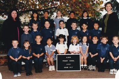 Sunshine and District Historical Society Incorporated
Photograph - Albion State School 2001 Class Photographs
... 5154.01 - Albion State School 2001 Grade 1 2T 5154.01 - Albion State School 2001 Grade 1 2T Names Back Row L2R Julie Ung Nathaniel Dizon Casey James Jesse Culhane Saamu Annie Lam Second Row L2R Jim Murphy Travis Montague Timothy ONeill Amy Caruana Smith Carl Schwencke Joshua Boudoloh Aaron McIntyre Front Row L2R Alfie Kennedy Danielle Williams Luc Owen Thuy Tran Elisa Mustafa Nicolle Reynolds Zoe Ward Narrell Raye Kieran Azzopardi Isaac McMillen Teachers Mrs Teresa Woods Mrs Angela Paschalidis Mrs Jann Turner Principal Mr Joe Vella 5154.02 - Albion State School 2001 Grade 2 3D 5154.02 - Albion State School 2001 Grade 2 3D Names Back Row L2R Melissa Hall James Schwencke Michael Nardella Tyson Stone Tarick Halaseh Jake Raye Kasey Davis Second Row L2R Jessica Nedelkovska Jade Burling Krystal Bogoevski Owen Malolo Billy Burrows Jayde Stanley Zorana Popovic Tiffany Smith Front Row L2R Nicole Williams Joshua Folino Amanda Mustafa Skakira Lever Laura Demicoli Jessica Heeps Ethan Morgan Luke Cleland Meyer Imran Clancy Rashid Absent Allyssa Leggerini Cavan Chen Teachers Miss Sandy Dennis Mrs Lorraine Farrugia Principal Mr Joe Vella 5154.03 - Albion State School 2001 Grade 3 4H 5154.03 - Albion State School 2001 Grade 3 4H Names Back Row L2R Daniel Kindred Callan Tishler Rachel Elliott David Kennedy Timothy McGrath Robert Reynolds Aidan Wileman Peter Mayne Second Row L2R Corine Markovic Rafael Protacio Cody Mayne Malgorzata Wasilewska Julie Rand Kelly Kennedy Dion Johnson Ladd John Merren Smart Front Row L2R Jennifer Williams Jennifer Truong Tony Tongpoon Ashley Skew Teagan Maguire Helen Ha Nicholas Davie Emily Folino Alisa Faingaanuku Tess The Dog Teacher Mrs Julie Hrovatin Principal Mr Joe Vella 5154.04 - Albion State School 2001 Grade 5 6H 5154.04 - Albion State School 2001 Grade 5 6H Names Back Row L2R Mitchell Pollard Sara Kindred Megan Montague Gul Resuloglu Jennifer Pucek Chantelle Noack Katherine ONeill Adam Stanley Second Row L2R James Durham Blake Cain Matthew Archer Justin Wemyss Brad Scott Binh Nguyen Matthew Gauci Garratt Stone Front Row L2R Cong Le Catherine Protacio Adis Husejnovic Patrick Geoghegan Caitlin Tippetd William Raye Anh Vu Meg McKinnon Robert Anderson Teacher Mr Wayne Haren Mrs Lorraine Farrugia Mrs Sandra Spurr Principal Mr Joe Vella 5154.06 - Albion State School 2001 Grade Prep 1B 5154.06 - Albion State School 2001 Grade Prep 1B Names Back Row L2R Brendan Stendt Nicholas Alexander Helena Guina Reece Mayne Jack Schofield Second Row L2R Melisa Husejnovic Meghan Douglas Christene Protacio Nathan Wineti Turde Ebony Wemyss Benjamin Britton Natalie coburn Annalise McMillan Front Row L2R Nhung Ha David Ung Kurtis Maguire Orlando Major Ashleigh Gauci Hayden Formossa Jayden Mamone Joshua Micallef Bethany Tippet Teacher Miss Elissa Barr Principal Mr Joe Vella 5154.07 - Albion State School 2001 Grade Prep 1G 5154.07 - Albion State School 2001 Grade Prep 1G Names Back Row L2R Milos Zarkovic My Bui Kristian Djulic Matthew McGrath Anthony Buttigieg Nicholas Burrows Jamie Megens Second Row L2R Aaron Mayne Luisa Malolo Carmen Rosca Kalista Uzelac Bojana Kakuca Jarrod Doherty Nikolce Blazeski Mile Ajder Emma Gruescu Front Row L2R Ashley Rattray Stephanie Nedelkovska David Tran Malea Culhane Saamu Luke DAlfonso Jessica Tawaf Naomi Truong Chelsea Lever Jennifer Ung Teachers Miss Marnie Galea Mrs Betty Batty Principal Mr Joe Vella 5154.08 - Albion State School 2001 House Captains 5154.09 - Albion State School 2001 JSC 5154.09 - Albion State School 2001 JSC Names Back Row L2R Reece Mayne Patrick Geoghegan Sara Kindred Rachel Elliott Samantha Williams Tim McGrath Thuy Vu Front Row L2R Nicole Williams Nikolce Blazeski Bojana Kakuca Zayne Duggan Ashleigh Gauci Amy Caruana Smith Minh Le Luke Cleland Meyer Isaac McMillen Teachers Miss Marnie Galea Miss Sandy Dennis Principal Mr Joe Vella 5154.10 - Albion State School 2001 Whole School 5154.11 - Albion State School 2001 Staff 5154.11 - Albion State School 2001 Staff Names Back Row L2R Lorraine Farrugia Sandy Dennis Julie Hrovatin John Milne Scott Garnsworthy Wayne Haren Angela Paschalidis Susan Carpenter Pat Porigneaux Front Row L2R Adrienne Erwood Jennifer Ryan Betty Batty Joe Vella Teresa Woods Elissa Barr Marnie Galea Absent Jann Turner...Albion State School Albion Primary School Adelaide Street Albion 5154.01 - Albion State School 2001 Grade 1 2T 5154.01 - Albion State School 2001 Grade 1 2T Names Back Row L2R Julie Ung Nathaniel Dizon Casey James Jesse Culhane Saamu Annie Lam Second Row L2R Jim Murphy Travis Montague Timothy ONeill Amy Caruana Smith Carl Schwencke Joshua Boudoloh Aaron McIntyre Front Row L2R Alfie Kennedy Danielle Williams Luc Owen Thuy Tran Elisa Mustafa Nicolle Reynolds Zoe Ward Narrell Raye Kieran Azzopardi Isaac McMillen Teachers Mrs Teresa Woods Mrs Angela Paschalidis Mrs Jann Turner Principal Mr Joe Vella 5154.02 - Albion State School 2001 Grade 2 3D 5154.02 - Albion State School 2001 Grade 2 3D Names Back Row L2R Melissa Hall James Schwencke Michael Nardella Tyson Stone Tarick Halaseh Jake Raye Kasey Davis Second Row L2R Jessica Nedelkovska Jade Burling Krystal Bogoevski Owen Malolo Billy Burrows Jayde Stanley Zorana Popovic Tiffany Smith Front Row L2R Nicole Williams Joshua Folino Amanda Mustafa Skakira Lever Laura Demicoli Jessica Heeps Ethan Morgan Luke Cleland Meyer Imran Clancy Rashid Absent Allyssa Leggerini Cavan Chen Teachers Miss Sandy Dennis Mrs Lorraine Farrugia Principal Mr Joe Vella 5154.03 - Albion State School 2001 Grade 3 4H 5154.03 - Albion State School 2001 Grade 3 4H Names Back Row L2R Daniel Kindred Callan Tishler Rachel Elliott David Kennedy Timothy McGrath Robert Reynolds Aidan Wileman Peter Mayne Second Row L2R Corine Markovic Rafael Protacio Cody Mayne Malgorzata Wasilewska Julie Rand Kelly Kennedy Dion Johnson Ladd John Merren Smart Front Row L2R Jennifer Williams Jennifer Truong Tony Tongpoon Ashley Skew Teagan Maguire Helen Ha Nicholas Davie Emily Folino Alisa Faingaanuku Tess The Dog Teacher Mrs Julie Hrovatin Principal Mr Joe Vella 5154.04 - Albion State School 2001 Grade 5 6H 5154.04 - Albion State School 2001 Grade 5 6H Names Back Row L2R Mitchell Pollard Sara Kindred Megan Montague Gul Resuloglu Jennifer Pucek Chantelle Noack Katherine ONeill Adam Stanley Second Row L2R James Durham Blake Cain Matthew Archer Justin Wemyss Brad Scott Binh Nguyen Matthew Gauci Garratt Stone Front Row L2R Cong Le Catherine Protacio Adis Husejnovic Patrick Geoghegan Caitlin Tippetd William Raye Anh Vu Meg McKinnon Robert Anderson Teacher Mr Wayne Haren Mrs Lorraine Farrugia Mrs Sandra Spurr Principal Mr Joe Vella 5154.06 - Albion State School 2001 Grade Prep 1B 5154.06 - Albion State School 2001 Grade Prep 1B Names Back Row L2R Brendan Stendt Nicholas Alexander Helena Guina Reece Mayne Jack Schofield Second Row L2R Melisa Husejnovic Meghan Douglas Christene Protacio Nathan Wineti Turde Ebony Wemyss Benjamin Britton Natalie coburn Annalise McMillan Front Row L2R Nhung Ha David Ung Kurtis Maguire Orlando Major Ashleigh Gauci Hayden Formossa Jayden Mamone Joshua Micallef Bethany Tippet Teacher Miss Elissa Barr Principal Mr Joe Vella 5154.07 - Albion State School 2001 Grade Prep 1G 5154.07 - Albion State School 2001 Grade Prep 1G Names Back Row L2R Milos Zarkovic My Bui Kristian Djulic Matthew McGrath Anthony Buttigieg Nicholas Burrows Jamie Megens Second Row L2R Aaron Mayne Luisa Malolo Carmen Rosca Kalista Uzelac Bojana Kakuca Jarrod Doherty Nikolce Blazeski Mile Ajder Emma Gruescu Front Row L2R Ashley Rattray Stephanie Nedelkovska David Tran Malea Culhane Saamu Luke DAlfonso Jessica Tawaf Naomi Truong Chelsea Lever Jennifer Ung Teachers Miss Marnie Galea Mrs Betty Batty Principal Mr Joe Vella 5154.08 - Albion State School 2001 House Captains 5154.09 - Albion State School 2001 JSC 5154.09 - Albion State School 2001 JSC Names Back Row L2R Reece Mayne Patrick Geoghegan Sara Kindred Rachel Elliott Samantha Williams Tim McGrath Thuy Vu Front Row L2R Nicole Williams Nikolce Blazeski Bojana Kakuca Zayne Duggan Ashleigh Gauci Amy Caruana Smith Minh Le Luke Cleland Meyer Isaac McMillen Teachers Miss Marnie Galea Miss Sandy Dennis Principal Mr Joe Vella 5154.10 - Albion State School 2001 Whole School 5154.11 - Albion State School 2001 Staff 5154.11 - Albion State School 2001 Staff Names Back Row L2R Lorraine Farrugia Sandy Dennis Julie Hrovatin John Milne Scott Garnsworthy Wayne Haren Angela Paschalidis Susan Carpenter Pat Porigneaux Front Row L2R Adrienne Erwood Jennifer Ryan Betty Batty Joe Vella Teresa Woods Elissa Barr Marnie Galea Absent Jann Turner Collection of Digital Photographs Photograph Albion State School 2001 Class Photographs ...The current school, Albion Primary School, No 4265 opened in 1926. It was built on a site once owned by John Fitzgerald (1850s). The land was later acquired by H. V. McKay who had transferred his Sunshine Harvester Works to the area in 1905 - 7. In 1920, the Albion railway station was moved nearer Ballarat Road at the request of Mr McKay. More people came to live in the area including soldier settlers.Albion Primary School's mission is to 'Aim High' in all we do so that our students grow to be socially capable, reach their full academic potential and become caring, respectful community minded people. Albion Primary School is located in a residential area in Albion, a small pocket of the local government area of Brimbank, approximately 10 kilometres west of Melbourne and was established in 1926. Our current enrolment is 199 students. We have a rich cultural diversity amongst our school community. The school is set around a courtyard with spacious playing areas including a grassed oval, running track, games courts, an adventure playground, sand pit, jumping pits, shady courtyard and garden areas, a vegetable garden and fruit tree orchard. As well as classroom groups, we have our learning teams, student house groups (siblings are allocated to the same house) and a Junior School Council. The school has four main buildings. All classrooms have air conditioning and interactive screens. Block A houses classrooms, staff areas and the administration offices. Our newest building has classrooms and some small group/office spaces. Block B includes our library, canteen and a multi-purpose room used for indoor physical education, Perceptual Motor Program, drama, visiting performers, and community activities. Block C houses classrooms and specialist rooms. We expect and receive the best from our students in terms of their learning and behaviour. The school’s dedicated and effective staff is strongly committed to helping students achieve personal, behavioural, social and academic success. In terms of learning, the highest priority is placed on the work in English and Mathematics. We also have a range of specialist and extra-curricular programs that we provide. Our specialist teacher-librarian is involved in reading extension programs that support development in literacy. All children are able to develop their artistic abilities through visual arts and music program. Our music program is supported by the Australian Children's Music Foundation. A specialist Physical Education teacher provides lessons for all children as well as the opportunity for students to participate in organised lunch time sporting competitions between the house groups. Auslan is the additional language all students learn at Albion. All children participate in a student wellbeing program that focuses on developing strong connections and a sense of belonging within the school. Our school student leaders participate in programs that help develop their leadership skills. 5154.01 - Albion State School 2001 Grade 1 2T 5154.01 - Albion State School 2001 Grade 1 2T Names Back Row L2R Julie Ung Nathaniel Dizon Casey James Jesse Culhane Saamu Annie Lam Second Row L2R Jim Murphy Travis Montague Timothy ONeill Amy Caruana Smith Carl Schwencke Joshua Boudoloh Aaron McIntyre Front Row L2R Alfie Kennedy Danielle Williams Luc Owen Thuy Tran Elisa Mustafa Nicolle Reynolds Zoe Ward Narrell Raye Kieran Azzopardi Isaac McMillen Teachers Mrs Teresa Woods Mrs Angela Paschalidis Mrs Jann Turner Principal Mr Joe Vella 5154.02 - Albion State School 2001 Grade 2 3D 5154.02 - Albion State School 2001 Grade 2 3D Names Back Row L2R Melissa Hall James Schwencke Michael Nardella Tyson Stone Tarick Halaseh Jake Raye Kasey Davis Second Row L2R Jessica Nedelkovska Jade Burling Krystal Bogoevski Owen Malolo Billy Burrows Jayde Stanley Zorana Popovic Tiffany Smith Front Row L2R Nicole Williams Joshua Folino Amanda Mustafa Skakira Lever Laura Demicoli Jessica Heeps Ethan Morgan Luke Cleland Meyer Imran Clancy Rashid Absent Allyssa Leggerini Cavan Chen Teachers Miss Sandy Dennis Mrs Lorraine Farrugia Principal Mr Joe Vella 5154.03 - Albion State School 2001 Grade 3 4H 5154.03 - Albion State School 2001 Grade 3 4H Names Back Row L2R Daniel Kindred Callan Tishler Rachel Elliott David Kennedy Timothy McGrath Robert Reynolds Aidan Wileman Peter Mayne Second Row L2R Corine Markovic Rafael Protacio Cody Mayne Malgorzata Wasilewska Julie Rand Kelly Kennedy Dion Johnson Ladd John Merren Smart Front Row L2R Jennifer Williams Jennifer Truong Tony Tongpoon Ashley Skew Teagan Maguire Helen Ha Nicholas Davie Emily Folino Alisa Faingaanuku Tess The Dog Teacher Mrs Julie Hrovatin Principal Mr Joe Vella 5154.04 - Albion State School 2001 Grade 5 6H 5154.04 - Albion State School 2001 Grade 5 6H Names Back Row L2R Mitchell Pollard Sara Kindred Megan Montague Gul Resuloglu Jennifer Pucek Chantelle Noack Katherine ONeill Adam Stanley Second Row L2R James Durham Blake Cain Matthew Archer Justin Wemyss Brad Scott Binh Nguyen Matthew Gauci Garratt Stone Front Row L2R Cong Le Catherine Protacio Adis Husejnovic Patrick Geoghegan Caitlin Tippetd William Raye Anh Vu Meg McKinnon Robert Anderson Teacher Mr Wayne Haren Mrs Lorraine Farrugia Mrs Sandra Spurr Principal Mr Joe Vella 5154.06 - Albion State School 2001 Grade Prep 1B 5154.06 - Albion State School 2001 Grade Prep 1B Names Back Row L2R Brendan Stendt Nicholas Alexander Helena Guina Reece Mayne Jack Schofield Second Row L2R Melisa Husejnovic Meghan Douglas Christene Protacio Nathan Wineti Turde Ebony Wemyss Benjamin Britton Natalie coburn Annalise McMillan Front Row L2R Nhung Ha David Ung Kurtis Maguire Orlando Major Ashleigh Gauci Hayden Formossa Jayden Mamone Joshua Micallef Bethany Tippet Teacher Miss Elissa Barr Principal Mr Joe Vella 5154.07 - Albion State School 2001 Grade Prep 1G 5154.07 - Albion State School 2001 Grade Prep 1G Names Back Row L2R Milos Zarkovic My Bui Kristian Djulic Matthew McGrath Anthony Buttigieg Nicholas Burrows Jamie Megens Second Row L2R Aaron Mayne Luisa Malolo Carmen Rosca Kalista Uzelac Bojana Kakuca Jarrod Doherty Nikolce Blazeski Mile Ajder Emma Gruescu Front Row L2R Ashley Rattray Stephanie Nedelkovska David Tran Malea Culhane Saamu Luke DAlfonso Jessica Tawaf Naomi Truong Chelsea Lever Jennifer Ung Teachers Miss Marnie Galea Mrs Betty Batty Principal Mr Joe Vella 5154.08 - Albion State School 2001 House Captains 5154.09 - Albion State School 2001 JSC 5154.09 - Albion State School 2001 JSC Names Back Row L2R Reece Mayne Patrick Geoghegan Sara Kindred Rachel Elliott Samantha Williams Tim McGrath Thuy Vu Front Row L2R Nicole Williams Nikolce Blazeski Bojana Kakuca Zayne Duggan Ashleigh Gauci Amy Caruana Smith Minh Le Luke Cleland Meyer Isaac McMillen Teachers Miss Marnie Galea Miss Sandy Dennis Principal Mr Joe Vella 5154.10 - Albion State School 2001 Whole School 5154.11 - Albion State School 2001 Staff 5154.11 - Albion State School 2001 Staff Names Back Row L2R Lorraine Farrugia Sandy Dennis Julie Hrovatin John Milne Scott Garnsworthy Wayne Haren Angela Paschalidis Susan Carpenter Pat Porigneaux Front Row L2R Adrienne Erwood Jennifer Ryan Betty Batty Joe Vella Teresa Woods Elissa Barr Marnie Galea Absent Jann Turneralbion state school, albion primary school, adelaide street, albion -
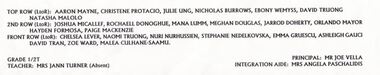 Sunshine and District Historical Society Incorporated
Photograph - Albion State School 2002 Class Photographs
... 5155.01 - Albion State School 2002 Grade 1 2T Names Back Row L2R Aaron Mayne Christene Protacio Julie Ung Nicholas Burrows Ebony Wemyss David Truong Natasha Malolo Second Row L2R Joshua Micallef Rochaell Donoghue Mana Lumm Meghan Douglas Jarrod Doherty Orlando Mayor Hayden Formosa Paige Mackenzie Front Row L2R Chelsea Lever Naomi Truong Nuri Nurhussien Stephanie Nedelkovska Emma Gruescu Ashleigh Gauci David Tran Zoe Ward Malea Culhane Saamu Teacher Mrs Jann Turner Mr Angela Paschalidis Principal Mr Joe Vella 5155.02 - Albion State School 2002 Grade 2 3M 5155.02 - Albion State School 2002 Grade 2 3M Names Back Row L2R Bethany Tippet Narrell Raye Aaron McIntyre Joshua Boudoloh Reece Mayne Travis Montague Jesse Culhane Saamu Nicolle Reynolds Second Row L2R Annie Lam Jessica Nedelkovska Paloma Donato Travis Blacket Tim ONeill Bojana Kakuca Thuy Tran Melissa Hall Front Row L2R Alfie Kennedy Imran Rashid Danielle Williams Jim Murphy Kobi HOle Marsden Chantel Attard Natalie Coburn Kieran Azzopardi Luke DAlfonso Teacher Ms Andrea Murray Principal Mr Joe Vella 5155.03 - Albion State School 2002 Grade 3 4H 5155.03 - Albion State School 2002 Grade 3 4H Names Back Row L2R Peter Mayne Safia Ali William Burrows David Kennedy Jesse Hearn James Schwencke Samantha Firth Second Row L2R Alisi Faingaanuku Jessica Heeps Nathaniel Dizon Owen Malolo Tarick Haleseh Amy Caruana Smith Ashley Skew Ethan Morgan Front Row L2R Nicole Williams Rahma Nurhussien Daniel Falzon Tiffany Smith Kasey Davis Natalie Miranda Zorana Popovic Jenny Le Shakira Lever Teacher Mrs Julie Hrovatin Mrs Lorraine Farrugia Principal Mr Joe Vella 5155.04 - Albion State School 2002 Grade 4 5R 5155.04 - Albion State School 2002 Grade 4 5R Names Back Row L2R Merren Smart Robert Reynolds Mitchell Durbin Zayne Duggan Cody Mayne Callan Tishler Ladd John Second Row L2R Nivaar Rolston Gosia Wasilewska Sam Malolo Stephanie Stronell Julie Rand Kelly Kennedy Aidan Wileman Michael Nardella Teagan Maguire Front Row L2R Jennifer Williams Daniel Kindred Corine Markovic Jade Formosa Nichalos Davie Jahnah Clark Luke Meyer Jake Raye Jennifer Truong Teacher Miss Jennifer Ryan Principal Mr Joe Vella 5155.05 - Albion State School 2002 Grade 6H 5155.05 - Albion State School 2002 Grade 6H Names Back Row L2R James Durham Kristy Ward Melissa Kennedy Sharnee Adams Courtney Teray Troy Maguire Steven Puckek Second Row L2R Shane Quinsee Steven Cameron IKamil Bulinski Megan Montague Phillip Cetwerschuk Mathew Smith Adis Husejnovic William Raye Absent Mathew Grima Teacher Mr Wayne Haren Mrs Sandra Spurr Principal Mr Joe Vella Front Row L2R 5155.06 - Albion State School 2002 Grade Prep 1B 5155.06 - Albion State School 2002 Grade Prep 1B Names Back Row L2R Travis Rand Benjamin Britton Jack Schofield John Huynh David Ung Second Row L2R Stephen Coburn Kurtis Maguire Jayde Page Milos Zarkovic Kaliesha Birch Melisa Husejnovic Tyson Freeman Annalise McMillan Front Row L2R Nerys Davie Chelsea TeRay Blake MacKenzie Brayden Lumm Mile Ajder Jordan Boudoloh Nhu Nguyen Jessica Tawaf Sang Lam Teacher Miss Elisaa Barr Mrs Betty Batty Principal Mr Joe Vella 5155.07 - Albion State School 2002 Grade Prep G 5155.07 - Albion State School 2002 Grade Prep G Names Back Row L2R Liam Noack Brendan Stendt Steven Firth Ashley Rattray Second Row L2R Cecilia Nguyen Jennifer Ung Dale Reynolds Samuel Miranda Kyle Durbin Sharon Mach Hani Mohammad Front Row L2R Shae Scholfield Kelvin Quach Brenden Smith Dean Pegram Amanda Mach Jamie Wooding Brandon Marsh Howe Alexis Ante Absent Elias Boudoloh Linh Tran Teacher Miss Marnie Galea Principal Mr Joe Vella 5155.08 - Albion State School 2002 Staff 5155.08 - Albion State School 2002 Staff Names Back Row L2R Marnie Galea Andrea Murray Elissa Barr John Milne Julie Hrovatin Sandra Spurr Jennifer Ryan Sandy Dennis Front Row L2R Lynn Mahoney Angela Paschalidis Susan Carpenter Joe Vella Teresa Woods Lorraine Farrugia Pt Porigneaux Absent Wayne Haren Jann Turner Betty Batty...Albion State School Albion Primary School Adelaide Street Albion 5155.01 - Albion State School 2002 Grade 1 2T Names Back Row L2R Aaron Mayne Christene Protacio Julie Ung Nicholas Burrows Ebony Wemyss David Truong Natasha Malolo Second Row L2R Joshua Micallef Rochaell Donoghue Mana Lumm Meghan Douglas Jarrod Doherty Orlando Mayor Hayden Formosa Paige Mackenzie Front Row L2R Chelsea Lever Naomi Truong Nuri Nurhussien Stephanie Nedelkovska Emma Gruescu Ashleigh Gauci David Tran Zoe Ward Malea Culhane Saamu Teacher Mrs Jann Turner Mr Angela Paschalidis Principal Mr Joe Vella 5155.02 - Albion State School 2002 Grade 2 3M 5155.02 - Albion State School 2002 Grade 2 3M Names Back Row L2R Bethany Tippet Narrell Raye Aaron McIntyre Joshua Boudoloh Reece Mayne Travis Montague Jesse Culhane Saamu Nicolle Reynolds Second Row L2R Annie Lam Jessica Nedelkovska Paloma Donato Travis Blacket Tim ONeill Bojana Kakuca Thuy Tran Melissa Hall Front Row L2R Alfie Kennedy Imran Rashid Danielle Williams Jim Murphy Kobi HOle Marsden Chantel Attard Natalie Coburn Kieran Azzopardi Luke DAlfonso Teacher Ms Andrea Murray Principal Mr Joe Vella 5155.03 - Albion State School 2002 Grade 3 4H 5155.03 - Albion State School 2002 Grade 3 4H Names Back Row L2R Peter Mayne Safia Ali William Burrows David Kennedy Jesse Hearn James Schwencke Samantha Firth Second Row L2R Alisi Faingaanuku Jessica Heeps Nathaniel Dizon Owen Malolo Tarick Haleseh Amy Caruana Smith Ashley Skew Ethan Morgan Front Row L2R Nicole Williams Rahma Nurhussien Daniel Falzon Tiffany Smith Kasey Davis Natalie Miranda Zorana Popovic Jenny Le Shakira Lever Teacher Mrs Julie Hrovatin Mrs Lorraine Farrugia Principal Mr Joe Vella 5155.04 - Albion State School 2002 Grade 4 5R 5155.04 - Albion State School 2002 Grade 4 5R Names Back Row L2R Merren Smart Robert Reynolds Mitchell Durbin Zayne Duggan Cody Mayne Callan Tishler Ladd John Second Row L2R Nivaar Rolston Gosia Wasilewska Sam Malolo Stephanie Stronell Julie Rand Kelly Kennedy Aidan Wileman Michael Nardella Teagan Maguire Front Row L2R Jennifer Williams Daniel Kindred Corine Markovic Jade Formosa Nichalos Davie Jahnah Clark Luke Meyer Jake Raye Jennifer Truong Teacher Miss Jennifer Ryan Principal Mr Joe Vella 5155.05 - Albion State School 2002 Grade 6H 5155.05 - Albion State School 2002 Grade 6H Names Back Row L2R James Durham Kristy Ward Melissa Kennedy Sharnee Adams Courtney Teray Troy Maguire Steven Puckek Second Row L2R Shane Quinsee Steven Cameron IKamil Bulinski Megan Montague Phillip Cetwerschuk Mathew Smith Adis Husejnovic William Raye Absent Mathew Grima Teacher Mr Wayne Haren Mrs Sandra Spurr Principal Mr Joe Vella Front Row L2R 5155.06 - Albion State School 2002 Grade Prep 1B 5155.06 - Albion State School 2002 Grade Prep 1B Names Back Row L2R Travis Rand Benjamin Britton Jack Schofield John Huynh David Ung Second Row L2R Stephen Coburn Kurtis Maguire Jayde Page Milos Zarkovic Kaliesha Birch Melisa Husejnovic Tyson Freeman Annalise McMillan Front Row L2R Nerys Davie Chelsea TeRay Blake MacKenzie Brayden Lumm Mile Ajder Jordan Boudoloh Nhu Nguyen Jessica Tawaf Sang Lam Teacher Miss Elisaa Barr Mrs Betty Batty Principal Mr Joe Vella 5155.07 - Albion State School 2002 Grade Prep G 5155.07 - Albion State School 2002 Grade Prep G Names Back Row L2R Liam Noack Brendan Stendt Steven Firth Ashley Rattray Second Row L2R Cecilia Nguyen Jennifer Ung Dale Reynolds Samuel Miranda Kyle Durbin Sharon Mach Hani Mohammad Front Row L2R Shae Scholfield Kelvin Quach Brenden Smith Dean Pegram Amanda Mach Jamie Wooding Brandon Marsh Howe Alexis Ante Absent Elias Boudoloh Linh Tran Teacher Miss Marnie Galea Principal Mr Joe Vella 5155.08 - Albion State School 2002 Staff 5155.08 - Albion State School 2002 Staff Names Back Row L2R Marnie Galea Andrea Murray Elissa Barr John Milne Julie Hrovatin Sandra Spurr Jennifer Ryan Sandy Dennis Front Row L2R Lynn Mahoney Angela Paschalidis Susan Carpenter Joe Vella Teresa Woods Lorraine Farrugia Pt Porigneaux Absent Wayne Haren Jann Turner Betty Batty Collection of Digital Photographs Photograph Albion State School 2002 Class Photographs ...The current school, Albion Primary School, No 4265 opened in 1926. It was built on a site once owned by John Fitzgerald (1850s). The land was later acquired by H. V. McKay who had transferred his Sunshine Harvester Works to the area in 1905 - 7. In 1920, the Albion railway station was moved nearer Ballarat Road at the request of Mr McKay. More people came to live in the area including soldier settlers.Albion Primary School's mission is to 'Aim High' in all we do so that our students grow to be socially capable, reach their full academic potential and become caring, respectful community minded people. Albion Primary School is located in a residential area in Albion, a small pocket of the local government area of Brimbank, approximately 10 kilometres west of Melbourne and was established in 1926. Our current enrolment is 199 students. We have a rich cultural diversity amongst our school community. The school is set around a courtyard with spacious playing areas including a grassed oval, running track, games courts, an adventure playground, sand pit, jumping pits, shady courtyard and garden areas, a vegetable garden and fruit tree orchard. As well as classroom groups, we have our learning teams, student house groups (siblings are allocated to the same house) and a Junior School Council. The school has four main buildings. All classrooms have air conditioning and interactive screens. Block A houses classrooms, staff areas and the administration offices. Our newest building has classrooms and some small group/office spaces. Block B includes our library, canteen and a multi-purpose room used for indoor physical education, Perceptual Motor Program, drama, visiting performers, and community activities. Block C houses classrooms and specialist rooms. We expect and receive the best from our students in terms of their learning and behaviour. The school’s dedicated and effective staff is strongly committed to helping students achieve personal, behavioural, social and academic success. In terms of learning, the highest priority is placed on the work in English and Mathematics. We also have a range of specialist and extra-curricular programs that we provide. Our specialist teacher-librarian is involved in reading extension programs that support development in literacy. All children are able to develop their artistic abilities through visual arts and music program. Our music program is supported by the Australian Children's Music Foundation. A specialist Physical Education teacher provides lessons for all children as well as the opportunity for students to participate in organised lunch time sporting competitions between the house groups. Auslan is the additional language all students learn at Albion. All children participate in a student wellbeing program that focuses on developing strong connections and a sense of belonging within the school. Our school student leaders participate in programs that help develop their leadership skills. 5155.01 - Albion State School 2002 Grade 1 2T Names Back Row L2R Aaron Mayne Christene Protacio Julie Ung Nicholas Burrows Ebony Wemyss David Truong Natasha Malolo Second Row L2R Joshua Micallef Rochaell Donoghue Mana Lumm Meghan Douglas Jarrod Doherty Orlando Mayor Hayden Formosa Paige Mackenzie Front Row L2R Chelsea Lever Naomi Truong Nuri Nurhussien Stephanie Nedelkovska Emma Gruescu Ashleigh Gauci David Tran Zoe Ward Malea Culhane Saamu Teacher Mrs Jann Turner Mr Angela Paschalidis Principal Mr Joe Vella 5155.02 - Albion State School 2002 Grade 2 3M 5155.02 - Albion State School 2002 Grade 2 3M Names Back Row L2R Bethany Tippet Narrell Raye Aaron McIntyre Joshua Boudoloh Reece Mayne Travis Montague Jesse Culhane Saamu Nicolle Reynolds Second Row L2R Annie Lam Jessica Nedelkovska Paloma Donato Travis Blacket Tim ONeill Bojana Kakuca Thuy Tran Melissa Hall Front Row L2R Alfie Kennedy Imran Rashid Danielle Williams Jim Murphy Kobi HOle Marsden Chantel Attard Natalie Coburn Kieran Azzopardi Luke DAlfonso Teacher Ms Andrea Murray Principal Mr Joe Vella 5155.03 - Albion State School 2002 Grade 3 4H 5155.03 - Albion State School 2002 Grade 3 4H Names Back Row L2R Peter Mayne Safia Ali William Burrows David Kennedy Jesse Hearn James Schwencke Samantha Firth Second Row L2R Alisi Faingaanuku Jessica Heeps Nathaniel Dizon Owen Malolo Tarick Haleseh Amy Caruana Smith Ashley Skew Ethan Morgan Front Row L2R Nicole Williams Rahma Nurhussien Daniel Falzon Tiffany Smith Kasey Davis Natalie Miranda Zorana Popovic Jenny Le Shakira Lever Teacher Mrs Julie Hrovatin Mrs Lorraine Farrugia Principal Mr Joe Vella 5155.04 - Albion State School 2002 Grade 4 5R 5155.04 - Albion State School 2002 Grade 4 5R Names Back Row L2R Merren Smart Robert Reynolds Mitchell Durbin Zayne Duggan Cody Mayne Callan Tishler Ladd John Second Row L2R Nivaar Rolston Gosia Wasilewska Sam Malolo Stephanie Stronell Julie Rand Kelly Kennedy Aidan Wileman Michael Nardella Teagan Maguire Front Row L2R Jennifer Williams Daniel Kindred Corine Markovic Jade Formosa Nichalos Davie Jahnah Clark Luke Meyer Jake Raye Jennifer Truong Teacher Miss Jennifer Ryan Principal Mr Joe Vella 5155.05 - Albion State School 2002 Grade 6H 5155.05 - Albion State School 2002 Grade 6H Names Back Row L2R James Durham Kristy Ward Melissa Kennedy Sharnee Adams Courtney Teray Troy Maguire Steven Puckek Second Row L2R Shane Quinsee Steven Cameron IKamil Bulinski Megan Montague Phillip Cetwerschuk Mathew Smith Adis Husejnovic William Raye Absent Mathew Grima Teacher Mr Wayne Haren Mrs Sandra Spurr Principal Mr Joe Vella Front Row L2R 5155.06 - Albion State School 2002 Grade Prep 1B 5155.06 - Albion State School 2002 Grade Prep 1B Names Back Row L2R Travis Rand Benjamin Britton Jack Schofield John Huynh David Ung Second Row L2R Stephen Coburn Kurtis Maguire Jayde Page Milos Zarkovic Kaliesha Birch Melisa Husejnovic Tyson Freeman Annalise McMillan Front Row L2R Nerys Davie Chelsea TeRay Blake MacKenzie Brayden Lumm Mile Ajder Jordan Boudoloh Nhu Nguyen Jessica Tawaf Sang Lam Teacher Miss Elisaa Barr Mrs Betty Batty Principal Mr Joe Vella 5155.07 - Albion State School 2002 Grade Prep G 5155.07 - Albion State School 2002 Grade Prep G Names Back Row L2R Liam Noack Brendan Stendt Steven Firth Ashley Rattray Second Row L2R Cecilia Nguyen Jennifer Ung Dale Reynolds Samuel Miranda Kyle Durbin Sharon Mach Hani Mohammad Front Row L2R Shae Scholfield Kelvin Quach Brenden Smith Dean Pegram Amanda Mach Jamie Wooding Brandon Marsh Howe Alexis Ante Absent Elias Boudoloh Linh Tran Teacher Miss Marnie Galea Principal Mr Joe Vella 5155.08 - Albion State School 2002 Staff 5155.08 - Albion State School 2002 Staff Names Back Row L2R Marnie Galea Andrea Murray Elissa Barr John Milne Julie Hrovatin Sandra Spurr Jennifer Ryan Sandy Dennis Front Row L2R Lynn Mahoney Angela Paschalidis Susan Carpenter Joe Vella Teresa Woods Lorraine Farrugia Pt Porigneaux Absent Wayne Haren Jann Turner Betty Battyalbion state school, albion primary school, adelaide street, albion -
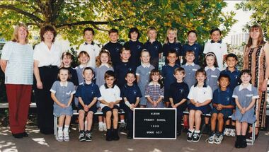 Sunshine and District Historical Society Incorporated
Photograph - Albion State School 1999 Class Photographs
... 5114.01 - Albion State School 1999 Grade 1 2F 5114.01 - Albion State School 1999 Grade 1 2F Names Back Row L2R Tyson Stone Michael Nardella Monique Zerni David Kennedy Robert Reynolds Dion Johnson Zayne Duggan 2nd Row L2R Jayde Stanley Malgorzata Wasilewska Julie Rand Timothy McGrath Olivia Moore Peter Horak Hayley Riley Kelly Kennedy Callan Tishler Front Row L2R Teagan Maguire Danield Kindred Dusan Karkovic Nichalos Davie Hannah Gray James Schwencke Lynda Ferrara Tony Tongpoon Emily Folino Absent Krystal Margaritis Principal Mr Joe Vella Teacher Mrs Ann Fabro 5114.02 - Albion State School 1999 Grade 2 3T 5114.02 - Albion State School 1999 Grade 2 3T Names Front Row L2R Rafael Potacio Rachel Elliott Melissa Kennedy Mathew Smith Mitchell Pollard Dylan Markovic Blake Cain 2nd Row L2R Stephanie Stronell Meg McKinnon Steven Pucek Macit Hasmaden Mathew Grima Simon Kinder Jack Wightman Jacqulyn TeRay Front Row Benjamin Milicevic Nikki Durham Caitlin Tippet Jared DAlfonso Tiani Megens Christopher Dymott Jade Formosa Miranda Hall Idil Yusuf Teachers Mrs Jann Turner Mrs Jan Talbot Principal Mr Joe Vella 5114.03 - Albion State School 1999 Grade 3 4H 5114.03 - Albion State School 1999 Grade 3 4H Names Back Row L2R Son Tran Megan Montague Chantelle Noack Priya Shah Jennifer Pucek Steve Bernacki Adis Husejnovic 2nd Row L2R Billy Morrow Yukun Liang Binh Nguyen Jilliah Johnson Farisha Zammit Daniel Harmsworth Gul Resuloglu Troy Maguire Helen Milsom Front Row L2R Thuy Vu Courtney TeRay Garratt Stone Alnh Vu Nicholas Rosener Jasmine Pecora Matthew Gauci Shane Quinsee Steven Cameron Principal Mr Joe Vella Teacher Mrs Julie Hrovatin 5114.04 - Albion State School 1999 Grade 4 5H 5114.04 - Albion State School 1999 Grade 4 5H Names Front Row L2R Lisa Broadwood Garry Gath Huriye Hasmaden Ricky Lyon Sarah Kennedy Stacey Hamilton 2nd Row L2R Alison Testa Rory Markovic Jessica James Jarrod Montague Heidi McKinnon Brody Woodbury Ricky Liddy Caterina Viterale Nicholas Miller Front Row L2R Matthew Archer Catherine Protacio Mathew Tiemes Gavin Stone Sara Kindred Bradley Rolfo Patrick Geoghegan Samantha Williams Robert Anderson Absent Tracey Coldrey Cong Le Principal Mr Joe Vella Teacher Mr Wayne Haren Integration Aide Mrs Betty Batty 5114.05 - Albion State School 1999 Grade 5 6D 5114.05 - Albion State School 1999 Grade 5 6D Names Back Row L2R Samantha Skew Matthew Baker Chase Horare Phi Nguyen Sarah Quinsee Samuel Sella 2nd Row L2R Paul Pecora Richard Elliott Benjamin Huynh Brodie Wightman Jacquiline Mayne Belman Turkusic Thuy Do Bradley Dale Terry Sinclair Front Row L2R Rebecca Trinh Dwayne Brown Anna Evangelista Miki ORegan Mary Nguyen Doreen Roberts Troy Strinovic Kellie Davis George Miller Absent Yen Le Principal Mr Joe Vella Teacher Mr Geoff Galloway Mrs Lorraine Farrugia Ms Sandy Dennis Absent 5114.06 - Albion State School 1999 Grade 6P 5114.06 - Albion State School 1999 Grade 6P Names Front Row L2R Darren Cain Rachel Testa Stephanie Theuma Madeline Burrows Mark King Kathleen Maguire Angel Protacio 2nd Row L2R Mark Micallef Tony Calhane Anthony Rolfo Amanda Kennedy Rachel Jude Beruke Yemane Dean Garrison Ryan Tishler Raja Shah Front Row L2R Michelle Gauci Krystal Spiteri Mahmut Resuloglu Aaron Batty Thong Tran Michael Woodhouse James Brown Chrystal Moore Andrew Demicoli Principal Mr Joe Vella Teacher Mrs Pat Porigneaux 5114.07 - Albion State School 1999 Grade Prep 1E 5114.07 - Albion State School 1999 Grade Prep 1E Names Back Row L2R Eduardo Riquelme Jenny Le Jessica Heeps Brooke Hamilton Helen Ha Corine Markovic Kasey Davis Jessy Kongsuwan 2nd Row L2R Jake Raye Sally Do Jennifer Truong Amy Caruana Smith Luke Harmsworth Tegan Wild Carl Schwencke Travis Montague Front Row L2R Shakira Lever Simone Schembri Luke Cleland Meyer Hien Huynh Laura Demicoli Jesse Culhane Saamu Alfie Kennedy Nicole Williams Principal Mr Joe Vella Teacher Mrs Adrienne Erwood Integration Aides Mr Pedro Batres Mrs Angela Paschalidis 5114.08 - Albion State School 1999 Grade Prep 1W 5114.08 - Albion State School 1999 Grade Prep 1W Names Back Row L2R Melissa Hall Aaron McIntyre Cavan Chen Sophie Marshall Molly Gray Tiffany Smith Ethan Morgan Amanda Mustafa 2nd Row L2R Joshue Boudoloh Joshua Folino William Burrows Aidan Wileman Cody Mayne Ashley Skew Jim James Murphy Annie Lam Front Row L2R Kieran Azzopardi Jessica Nedelkovska Bradley Stockdale Casey James Rachael Buckley Mohamed Yusuf Jenny Williams Imran Clancy Absent Julie Ung Chantelle Langanke Principal Mr Joe Vella Techer Mrs Teresa Wood Integration Aide Mrs Betty Batty 5114.09 - Albion State School 1999 Grade House Captains 5114.09 - Albion State School 1999 Grade House Captains Names Back Row L2R Aaron Batty Kathleen Maguire Mr Vella Rachael Testa Ryan Tishlet Front Row L2R Anna Evangelista Angel Protacio Darren Cain Sarah Quinsee 5114.10 - Albion State School 1999 Grade Staff 5114.10 - Albion State School 1999 Grade Staff Names Back Row L2R Pat Porigneaux Joy Farrell Pedro Batres Teresa Woods Geoff Galloway Wayne Haren Ann Fabbro Lorraine Farrugia Vesna Begovic Front Row L2R Betty Batty Adrienne Erwood Jan Talbot Joe Vella Jann Turner Angela Paschalidis Robyn Pope Absent Julie Hrovatin Sandy Dennis Susan Carpenter...Albion State School Albion Primary School Adelaide Street Albion 5114.01 - Albion State School 1999 Grade 1 2F 5114.01 - Albion State School 1999 Grade 1 2F Names Back Row L2R Tyson Stone Michael Nardella Monique Zerni David Kennedy Robert Reynolds Dion Johnson Zayne Duggan 2nd Row L2R Jayde Stanley Malgorzata Wasilewska Julie Rand Timothy McGrath Olivia Moore Peter Horak Hayley Riley Kelly Kennedy Callan Tishler Front Row L2R Teagan Maguire Danield Kindred Dusan Karkovic Nichalos Davie Hannah Gray James Schwencke Lynda Ferrara Tony Tongpoon Emily Folino Absent Krystal Margaritis Principal Mr Joe Vella Teacher Mrs Ann Fabro 5114.02 - Albion State School 1999 Grade 2 3T 5114.02 - Albion State School 1999 Grade 2 3T Names Front Row L2R Rafael Potacio Rachel Elliott Melissa Kennedy Mathew Smith Mitchell Pollard Dylan Markovic Blake Cain 2nd Row L2R Stephanie Stronell Meg McKinnon Steven Pucek Macit Hasmaden Mathew Grima Simon Kinder Jack Wightman Jacqulyn TeRay Front Row Benjamin Milicevic Nikki Durham Caitlin Tippet Jared DAlfonso Tiani Megens Christopher Dymott Jade Formosa Miranda Hall Idil Yusuf Teachers Mrs Jann Turner Mrs Jan Talbot Principal Mr Joe Vella 5114.03 - Albion State School 1999 Grade 3 4H 5114.03 - Albion State School 1999 Grade 3 4H Names Back Row L2R Son Tran Megan Montague Chantelle Noack Priya Shah Jennifer Pucek Steve Bernacki Adis Husejnovic 2nd Row L2R Billy Morrow Yukun Liang Binh Nguyen Jilliah Johnson Farisha Zammit Daniel Harmsworth Gul Resuloglu Troy Maguire Helen Milsom Front Row L2R Thuy Vu Courtney TeRay Garratt Stone Alnh Vu Nicholas Rosener Jasmine Pecora Matthew Gauci Shane Quinsee Steven Cameron Principal Mr Joe Vella Teacher Mrs Julie Hrovatin 5114.04 - Albion State School 1999 Grade 4 5H 5114.04 - Albion State School 1999 Grade 4 5H Names Front Row L2R Lisa Broadwood Garry Gath Huriye Hasmaden Ricky Lyon Sarah Kennedy Stacey Hamilton 2nd Row L2R Alison Testa Rory Markovic Jessica James Jarrod Montague Heidi McKinnon Brody Woodbury Ricky Liddy Caterina Viterale Nicholas Miller Front Row L2R Matthew Archer Catherine Protacio Mathew Tiemes Gavin Stone Sara Kindred Bradley Rolfo Patrick Geoghegan Samantha Williams Robert Anderson Absent Tracey Coldrey Cong Le Principal Mr Joe Vella Teacher Mr Wayne Haren Integration Aide Mrs Betty Batty 5114.05 - Albion State School 1999 Grade 5 6D 5114.05 - Albion State School 1999 Grade 5 6D Names Back Row L2R Samantha Skew Matthew Baker Chase Horare Phi Nguyen Sarah Quinsee Samuel Sella 2nd Row L2R Paul Pecora Richard Elliott Benjamin Huynh Brodie Wightman Jacquiline Mayne Belman Turkusic Thuy Do Bradley Dale Terry Sinclair Front Row L2R Rebecca Trinh Dwayne Brown Anna Evangelista Miki ORegan Mary Nguyen Doreen Roberts Troy Strinovic Kellie Davis George Miller Absent Yen Le Principal Mr Joe Vella Teacher Mr Geoff Galloway Mrs Lorraine Farrugia Ms Sandy Dennis Absent 5114.06 - Albion State School 1999 Grade 6P 5114.06 - Albion State School 1999 Grade 6P Names Front Row L2R Darren Cain Rachel Testa Stephanie Theuma Madeline Burrows Mark King Kathleen Maguire Angel Protacio 2nd Row L2R Mark Micallef Tony Calhane Anthony Rolfo Amanda Kennedy Rachel Jude Beruke Yemane Dean Garrison Ryan Tishler Raja Shah Front Row L2R Michelle Gauci Krystal Spiteri Mahmut Resuloglu Aaron Batty Thong Tran Michael Woodhouse James Brown Chrystal Moore Andrew Demicoli Principal Mr Joe Vella Teacher Mrs Pat Porigneaux 5114.07 - Albion State School 1999 Grade Prep 1E 5114.07 - Albion State School 1999 Grade Prep 1E Names Back Row L2R Eduardo Riquelme Jenny Le Jessica Heeps Brooke Hamilton Helen Ha Corine Markovic Kasey Davis Jessy Kongsuwan 2nd Row L2R Jake Raye Sally Do Jennifer Truong Amy Caruana Smith Luke Harmsworth Tegan Wild Carl Schwencke Travis Montague Front Row L2R Shakira Lever Simone Schembri Luke Cleland Meyer Hien Huynh Laura Demicoli Jesse Culhane Saamu Alfie Kennedy Nicole Williams Principal Mr Joe Vella Teacher Mrs Adrienne Erwood Integration Aides Mr Pedro Batres Mrs Angela Paschalidis 5114.08 - Albion State School 1999 Grade Prep 1W 5114.08 - Albion State School 1999 Grade Prep 1W Names Back Row L2R Melissa Hall Aaron McIntyre Cavan Chen Sophie Marshall Molly Gray Tiffany Smith Ethan Morgan Amanda Mustafa 2nd Row L2R Joshue Boudoloh Joshua Folino William Burrows Aidan Wileman Cody Mayne Ashley Skew Jim James Murphy Annie Lam Front Row L2R Kieran Azzopardi Jessica Nedelkovska Bradley Stockdale Casey James Rachael Buckley Mohamed Yusuf Jenny Williams Imran Clancy Absent Julie Ung Chantelle Langanke Principal Mr Joe Vella Techer Mrs Teresa Wood Integration Aide Mrs Betty Batty 5114.09 - Albion State School 1999 Grade House Captains 5114.09 - Albion State School 1999 Grade House Captains Names Back Row L2R Aaron Batty Kathleen Maguire Mr Vella Rachael Testa Ryan Tishlet Front Row L2R Anna Evangelista Angel Protacio Darren Cain Sarah Quinsee 5114.10 - Albion State School 1999 Grade Staff 5114.10 - Albion State School 1999 Grade Staff Names Back Row L2R Pat Porigneaux Joy Farrell Pedro Batres Teresa Woods Geoff Galloway Wayne Haren Ann Fabbro Lorraine Farrugia Vesna Begovic Front Row L2R Betty Batty Adrienne Erwood Jan Talbot Joe Vella Jann Turner Angela Paschalidis Robyn Pope Absent Julie Hrovatin Sandy Dennis Susan Carpenter Collection of Digital Photographs Photograph Albion State School 1999 Class Photographs ...The current school, Albion Primary School, No 4265 opened in 1926. It was built on a site once owned by John Fitzgerald (1850s). The land was later acquired by H. V. McKay who had transferred his Sunshine Harvester Works to the area in 1905 - 7. In 1920, the Albion railway station was moved nearer Ballarat Road at the request of Mr McKay. More people came to live in the area including soldier settlers.Albion Primary School's mission is to 'Aim High' in all we do so that our students grow to be socially capable, reach their full academic potential and become caring, respectful community minded people. Albion Primary School is located in a residential area in Albion, a small pocket of the local government area of Brimbank, approximately 10 kilometres west of Melbourne and was established in 1926. Our current enrolment is 199 students. We have a rich cultural diversity amongst our school community. The school is set around a courtyard with spacious playing areas including a grassed oval, running track, games courts, an adventure playground, sand pit, jumping pits, shady courtyard and garden areas, a vegetable garden and fruit tree orchard. As well as classroom groups, we have our learning teams, student house groups (siblings are allocated to the same house) and a Junior School Council. The school has four main buildings. All classrooms have air conditioning and interactive screens. Block A houses classrooms, staff areas and the administration offices. Our newest building has classrooms and some small group/office spaces. Block B includes our library, canteen and a multi-purpose room used for indoor physical education, Perceptual Motor Program, drama, visiting performers, and community activities. Block C houses classrooms and specialist rooms. We expect and receive the best from our students in terms of their learning and behaviour. The school’s dedicated and effective staff is strongly committed to helping students achieve personal, behavioural, social and academic success. In terms of learning, the highest priority is placed on the work in English and Mathematics. We also have a range of specialist and extra-curricular programs that we provide. Our specialist teacher-librarian is involved in reading extension programs that support development in literacy. All children are able to develop their artistic abilities through visual arts and music program. Our music program is supported by the Australian Children's Music Foundation. A specialist Physical Education teacher provides lessons for all children as well as the opportunity for students to participate in organised lunch time sporting competitions between the house groups. Auslan is the additional language all students learn at Albion. All children participate in a student wellbeing program that focuses on developing strong connections and a sense of belonging within the school. Our school student leaders participate in programs that help develop their leadership skills. 5114.01 - Albion State School 1999 Grade 1 2F 5114.01 - Albion State School 1999 Grade 1 2F Names Back Row L2R Tyson Stone Michael Nardella Monique Zerni David Kennedy Robert Reynolds Dion Johnson Zayne Duggan 2nd Row L2R Jayde Stanley Malgorzata Wasilewska Julie Rand Timothy McGrath Olivia Moore Peter Horak Hayley Riley Kelly Kennedy Callan Tishler Front Row L2R Teagan Maguire Danield Kindred Dusan Karkovic Nichalos Davie Hannah Gray James Schwencke Lynda Ferrara Tony Tongpoon Emily Folino Absent Krystal Margaritis Principal Mr Joe Vella Teacher Mrs Ann Fabro 5114.02 - Albion State School 1999 Grade 2 3T 5114.02 - Albion State School 1999 Grade 2 3T Names Front Row L2R Rafael Potacio Rachel Elliott Melissa Kennedy Mathew Smith Mitchell Pollard Dylan Markovic Blake Cain 2nd Row L2R Stephanie Stronell Meg McKinnon Steven Pucek Macit Hasmaden Mathew Grima Simon Kinder Jack Wightman Jacqulyn TeRay Front Row Benjamin Milicevic Nikki Durham Caitlin Tippet Jared DAlfonso Tiani Megens Christopher Dymott Jade Formosa Miranda Hall Idil Yusuf Teachers Mrs Jann Turner Mrs Jan Talbot Principal Mr Joe Vella 5114.03 - Albion State School 1999 Grade 3 4H 5114.03 - Albion State School 1999 Grade 3 4H Names Back Row L2R Son Tran Megan Montague Chantelle Noack Priya Shah Jennifer Pucek Steve Bernacki Adis Husejnovic 2nd Row L2R Billy Morrow Yukun Liang Binh Nguyen Jilliah Johnson Farisha Zammit Daniel Harmsworth Gul Resuloglu Troy Maguire Helen Milsom Front Row L2R Thuy Vu Courtney TeRay Garratt Stone Alnh Vu Nicholas Rosener Jasmine Pecora Matthew Gauci Shane Quinsee Steven Cameron Principal Mr Joe Vella Teacher Mrs Julie Hrovatin 5114.04 - Albion State School 1999 Grade 4 5H 5114.04 - Albion State School 1999 Grade 4 5H Names Front Row L2R Lisa Broadwood Garry Gath Huriye Hasmaden Ricky Lyon Sarah Kennedy Stacey Hamilton 2nd Row L2R Alison Testa Rory Markovic Jessica James Jarrod Montague Heidi McKinnon Brody Woodbury Ricky Liddy Caterina Viterale Nicholas Miller Front Row L2R Matthew Archer Catherine Protacio Mathew Tiemes Gavin Stone Sara Kindred Bradley Rolfo Patrick Geoghegan Samantha Williams Robert Anderson Absent Tracey Coldrey Cong Le Principal Mr Joe Vella Teacher Mr Wayne Haren Integration Aide Mrs Betty Batty 5114.05 - Albion State School 1999 Grade 5 6D 5114.05 - Albion State School 1999 Grade 5 6D Names Back Row L2R Samantha Skew Matthew Baker Chase Horare Phi Nguyen Sarah Quinsee Samuel Sella 2nd Row L2R Paul Pecora Richard Elliott Benjamin Huynh Brodie Wightman Jacquiline Mayne Belman Turkusic Thuy Do Bradley Dale Terry Sinclair Front Row L2R Rebecca Trinh Dwayne Brown Anna Evangelista Miki ORegan Mary Nguyen Doreen Roberts Troy Strinovic Kellie Davis George Miller Absent Yen Le Principal Mr Joe Vella Teacher Mr Geoff Galloway Mrs Lorraine Farrugia Ms Sandy Dennis Absent 5114.06 - Albion State School 1999 Grade 6P 5114.06 - Albion State School 1999 Grade 6P Names Front Row L2R Darren Cain Rachel Testa Stephanie Theuma Madeline Burrows Mark King Kathleen Maguire Angel Protacio 2nd Row L2R Mark Micallef Tony Calhane Anthony Rolfo Amanda Kennedy Rachel Jude Beruke Yemane Dean Garrison Ryan Tishler Raja Shah Front Row L2R Michelle Gauci Krystal Spiteri Mahmut Resuloglu Aaron Batty Thong Tran Michael Woodhouse James Brown Chrystal Moore Andrew Demicoli Principal Mr Joe Vella Teacher Mrs Pat Porigneaux 5114.07 - Albion State School 1999 Grade Prep 1E 5114.07 - Albion State School 1999 Grade Prep 1E Names Back Row L2R Eduardo Riquelme Jenny Le Jessica Heeps Brooke Hamilton Helen Ha Corine Markovic Kasey Davis Jessy Kongsuwan 2nd Row L2R Jake Raye Sally Do Jennifer Truong Amy Caruana Smith Luke Harmsworth Tegan Wild Carl Schwencke Travis Montague Front Row L2R Shakira Lever Simone Schembri Luke Cleland Meyer Hien Huynh Laura Demicoli Jesse Culhane Saamu Alfie Kennedy Nicole Williams Principal Mr Joe Vella Teacher Mrs Adrienne Erwood Integration Aides Mr Pedro Batres Mrs Angela Paschalidis 5114.08 - Albion State School 1999 Grade Prep 1W 5114.08 - Albion State School 1999 Grade Prep 1W Names Back Row L2R Melissa Hall Aaron McIntyre Cavan Chen Sophie Marshall Molly Gray Tiffany Smith Ethan Morgan Amanda Mustafa 2nd Row L2R Joshue Boudoloh Joshua Folino William Burrows Aidan Wileman Cody Mayne Ashley Skew Jim James Murphy Annie Lam Front Row L2R Kieran Azzopardi Jessica Nedelkovska Bradley Stockdale Casey James Rachael Buckley Mohamed Yusuf Jenny Williams Imran Clancy Absent Julie Ung Chantelle Langanke Principal Mr Joe Vella Techer Mrs Teresa Wood Integration Aide Mrs Betty Batty 5114.09 - Albion State School 1999 Grade House Captains 5114.09 - Albion State School 1999 Grade House Captains Names Back Row L2R Aaron Batty Kathleen Maguire Mr Vella Rachael Testa Ryan Tishlet Front Row L2R Anna Evangelista Angel Protacio Darren Cain Sarah Quinsee 5114.10 - Albion State School 1999 Grade Staff 5114.10 - Albion State School 1999 Grade Staff Names Back Row L2R Pat Porigneaux Joy Farrell Pedro Batres Teresa Woods Geoff Galloway Wayne Haren Ann Fabbro Lorraine Farrugia Vesna Begovic Front Row L2R Betty Batty Adrienne Erwood Jan Talbot Joe Vella Jann Turner Angela Paschalidis Robyn Pope Absent Julie Hrovatin Sandy Dennis Susan Carpenteralbion state school, albion primary school, adelaide street, albion -
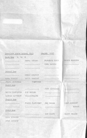 Sunshine and District Historical Society Incorporated
Photograph - Sunshine State School 3112 Class Photographs and Class Lists 1929 - 1932
... Photograph Sunshine State School Grade 3 1928 Back Row L to R Ida Duncan Ruth Wood Alison Meyers Peggy Riley Jean Cawood Unknown Jean Whittingham Second Row L to R Vera Blackburn Gladys Jackson Edna Pontin Audrey Talintyre Unknown Beryl Brown Florrie McVitty Muriel Bentley Third Row L to R Unknown Unknown Pat Dalling Unknown Marion Clifton Norma Rogers Pearl Mitchell Dorothy McElhinney Annie McVitty Unknown Fourth Row L to R Unknown David Templeton Doug Robertson Unknown John Pengelly Bob Parsons Kevin Holman Unknown Unknown Gordon Duncan Walter Carruthers Unknown Fifth Row L to R Dick Whiting Charlie Gist Jack Duxon Unknown Unknown Unknown Evan Davidson Unknown Sixth Rown L to R Jim Scott Bill Smith Ian Perry Unknown Norm Pengelly Reg Hogan Bill Avery Bob James Des Goode|Photograph and list of names Sunshine State School Grade 2 1927 Back Row L to R Ida Duncan Unknown Edna Pritchard Unknown Unknown Unknown Beryl Brown Unknown Betty Lindsay Second Row L to R Unknown Mr Slater Alison Meyers Edna Harris Unknown Unknown Unknown Gladys Jackson Unknown Third Row L to R Gordon Duncan Unknown Dick Whiting Unknown Bill Smith Des Goode Bill Searle Unknown Bill Avery Unknown Fourth Row L to R Unknown Norm Pengelly Pat Dalling Jack Scobie Ian Perry Unknown Charlie Gist Jim Hogan Frank Scott Jim Gilson Front Row L to R Harry Curtin Evan Davidson Harry Holman Don Mayes Unknown Jim Scott Unknown Unknown Unknown Reg Hogan|Photograph and list of names Sunshine State School Grade 1 1927 Back Row L to R Unknown Beryl Styles Florence Bird Jessie Hoskins Unknown Unknown Edna Harris Unknown Unknown Unknown Unknown Second Row L to R Unknown Doris Adamson Unknown Unknown Edna Pontin Betty Barclay Unknown Unknown Pearl Mitchell Miss Fletcher Third Row L to R Unknown Unknown Jeff Richards Unknown David Templeton Joe Moiler Unknown Unknown Laurie Kittelty Willy Whaite Unknown Fourth Row L to R Unknown Frank Fletcher Des Goode Bert Johnson Unknown Unknown Unknown Mr Hogan Front Row L to R Unknown Unknown Ron Smith Harry Fraser Bill Nielsen Unknown Unknown Unknown Stan Jowett|Photograph and list of names Sunshine State School Grade 1 Back Row L to R Unknown Unknown Veronica Goodwin Phyl Mounsey Jaqui Haxby Miss Mayo Unknown Unknown Second Row L to R Unknown Unknown Miss Porter Evelyn Shilston Unknown Glen Taylor Mavis Thomson Unknown Merle Armour Unknown Unknown Unknown Edith Larcobe Third Row L to R Margaret Davies Norm Talintyre Unknown Unknown Unknown Unknown Unknown Unknown Unknown Unknown Unknown Unknown Unknown Front row L to R Max Brown Unknown Linton Learmonth Unknown Andy Kyle Unknown Unknown Unknown Unknown|Photograph and list of names Sunshine State School Grade Prep 1928 Back Row L to R Jean Haworth Kitty Marsh Ina Jackson Beryl Rohner Thelma Carruthers Merle Clark Thelma Carruthers Marjorie Sharp Vena Thompson Second Row L to R Maisie Pibbs Edna Clifton Eva Bromson Eula Barkly Betty Halliday Unknown Nancy Drennan Audrey Hibbert Lesley Barker Front Row L to R Jack Steward Bill Paton Max Hargreaves Syd Gill Arthur Jowett Jim Moiler Frank Paul Reg Barclay Clarrie Roberts Jack Blight|Photograph and list of names Sunshine State School Grade 4 1929 Back Row L to R Unknown Maisie King Norma Rogers Jean Cawood Dorothy McElhinney Beryl Brown Vera Blackburn Second Row L to R Sadie Stock Ida Duncan Unknown Unknown Unknown Gladys Jackson Marion Clifton Miss Keeble Front Row L to R Unkown Eunice McBean Muriel Bentley Unknown Ruth Wood Peggy Riley Annie McVitty Florrie McVitty|Photograph and list of names Sunshine State School Grade 2 1929 Back Row L to R Audrey Hibbert Marion Tribe Unknown Marjorie Sharp Unknown Miss Polkinghorn Unknown Thelma Carruthers Joyce Hogan Second Row L to R Betty Halliday Joan Barclay Evelyn Mayo Eva Bromson Gertie Roberts Iris Carr Jean Mounsey Valda Ormiston Unknown Ina Jackson Phyl Greenham Edna Clifton Doreen Johnson Margaret McPherson Third Row L to R Lois Carter Lesley Barker Beryl Rohner Ivy Huggins Nancy Drennan Mr Moiler Bill Paton Syd Gill Unknown Unknown Arthur Jowett Max Hargreaves Unknown Maria Johnson Four Row L to R Unknown Unknown Unknown Unknown Stan Oswin Phil Davey Unknown Clarrie Roberts Len Duxon Unknown Tom Tribe Front Row Unknown Unknown Reg Barclay Ivan Carland Mr Patrick Mr Davidson Jim Reynolds Mr Fowler|Photograph and list of names Sunshine State School Grade 4 1929 Back Row L to R John Pengelley Jim Patterson Dave McGregor Jim Singleton Doug Robertson Harry Curtin Howard Gill Reg Hogan Ron Pattin Walter Carruthers Jack Duxon Gordon Duncan Unknown Unknown Unknown Jack Pontin Don Mayes Third Row L to R Jim Gilson Jack Frazer Unknown Bob Parsons Charlie Gist Dick Darby Jim Lynch Norm Pengelley Unknown Les Mudford Pat Dalling Front Row L to R Ron Thompson Bill Searle Evan Perry David Templeton Dick Whiting Bill Avery Evan Davidson Des Goode Jim Scott|Photograph and list of names Sunshine State School Grade 5B 1932 Back Row L to R Reg Seymour Kevin Lorenz Leo Martin Cyril Antony Norm Carland Bill Perry P Moiler Lionel Barnes Graham Roberts Lloyd Clark Willie Scott Max Hargreaves Second Row L to R Lesley Barker Joyce Hogan Iris Carr Eula Barkla Ina Jackson Marjorie Styles Dorothy Dean Jeanette Robertson Marjorie Sharp Merle Clark Thelma Carruthers Rose Brock B Herweg Edna Krause Third Row L to R Marion Tribe Eileen Hutton Gertie Roberts Jean Peeler Irene Day Lesley Petherick Beth Perry Valda Ormiston Marie Johnson Valda Brown Millie Howard Front Row L to R Bill Paton Len Duxon W Mitchell Geoff Taylor Ron Ferrell Ron Scanlon Russell Learmonth Mr Moiler Unknown Mr Chalmers Norm Carlton A Stoneham Arch McGilvrey Mr Patrick Keith Davey Arthur Jowett|Photograph and list of names Sunshine State School Grade 5A 1932 Back Row L to R Clarrie Roberts Unknown Jim Reynolds W Wood Unknown Unknown Fergus Gray Mr Davidson Ron Skewes Sid Gill Mr Moiler Second Row L to R Lillian Scobie Faith Fraser Unknown Unknown Unknown Unknown B Steer Beryl Rohner Ivy Carlyle Joan Oswin Ethel Smith Margaret McPherson Melba Warren Vena Thompson Eunice Lindsay Heather Hyett Doreen Johnson Third Row L to R Valda Spuring Elsie Hewitt Jean Mousey Laura Booth Susan Davidson Peggy Johnson Sissie Picken Betty Halliday Eva Bromson Ann Slater Unknown Phyl Greenham Ivy Huggins Nancy Drennan Audrey Hibbert Maisie Hibbs Edna Clifton Front Row L to R Tom Tribe R Crompton Unknown Unknown Bill Evans Unknown Jack Blight Unknown Peter Challen|Photograph and list of names Sunshine State School Grade 5 1930 Back Row L to R Jack Pontin David Templeton Charlie Gist Dick Whiting Unknown Frank Scott Des Goode Harold Gill Jim Singleton Doug Robertson Second Row L to R Ian Perry Jim Scott Evan Davidson Harry Curtin Pat Dalling Ted Napier Norm Pengelley Jack Duxon Jim Gilson Unknown Third Row L to R Ron Paton Unknown Max Howie Dick Darby Bill Searle Bill Smith Jim Patterson Gordon Duncan Walter Carruthers Jim Lynch Front Row L to R Bob Parsons Jack Frazer Les Mudford Bob Barkla John Pengelley Unknown Unknown Reg Hogan Don Mayo Bill Avery|Photograph and list of names Sunshine State School Grade 3 1930 Back Row L to R W Wood Russell Learmonth Jack Steward Ron Farrell Fergus Gray Mr Davidson Norm Carland Cecil Antony Lionel Barnes Lloyd Clark Bill Paton Tom Tribe Unknown Unknown Clarrie Roberts Geoff Taylor Second Row L to R Nancy Drennan Ethel Smith Eunice Lindsay Dorothy Dean Eula Barkla Jeanette Robinson B Steer T Carlisle Beryl Rohner Vena Thompson Unknown Marjorie Styles Rose Brock Edna Clifton Third Row L to R Eva Bromson Lesley Petherick Unknown Ina Jackson Jean Haworth Lesley Barker Susan Davidson Audrey Hibbert Marion Tribe Lillian Scobie Eileen Hutton Fourth Row L to R Betty Halliday Beth Perry Jean Mounsey Elsie Hewitt Joyce Hogan Margaret McPherson Marie Johnson Heather Hyett Gwenda Pommeroy Marjorie Sharp Joan Barkla Gertie Roberts Ivy Huggins Front Row L to R Unknown Jack Blight Arthur Jowett Ivan Carland Len Duxon Ron Skewes Max Hargreaves Mr Fowler Phil Davey Reg Barclay|Photograph and list of names Sunshine State School Grade 6B 1933 Back Row L to R Leo Martin Graham Roberts Max Hargreaves Unknown Stan Oswin Lionel Barnes Clarrie Roberts Jack Steward Arthur Jowett Lloyd Clark Second Row L to R Audrey Hibbert Elsie Hewitt Ina Jackson Majorie Styles Jeanette Robinson Joan Oswin Unknown Merle Clark Thelma Carruthers B Steer Jean Peeler Iris Carr Third Row L to R Heather Hyett Valda Spurling Jean Mounsey Sissie Picken Dorothy Dean Eileen Went Gertie Roberts Joan Barkla Peggy Johnson Unknown Eva Bromson Joyce Hogan Ivy Huggins Marie Johnson Front Row L to R Norm Carlton Sid Gill Bill Evans Ivan Carland Jack Blight Unknown Ray Crompton A Stoneham Arthur Field Unknown Ron Ferrell Cecil Perkins Ron Scanlon Peter Challen Stan Jowett....Sunshine State School State School Hampshire Road Sunshine Student Photograph Photograph Sunshine State School Grade 3 1928 Back Row L to R Ida Duncan Ruth Wood Alison Meyers Peggy Riley Jean Cawood Unknown Jean Whittingham Second Row L to R Vera Blackburn Gladys Jackson Edna Pontin Audrey Talintyre Unknown Beryl Brown Florrie McVitty Muriel Bentley Third Row L to R Unknown Unknown Pat Dalling Unknown Marion Clifton Norma Rogers Pearl Mitchell Dorothy McElhinney Annie McVitty Unknown Fourth Row L to R Unknown David Templeton Doug Robertson Unknown John Pengelly Bob Parsons Kevin Holman Unknown Unknown Gordon Duncan Walter Carruthers Unknown Fifth Row L to R Dick Whiting Charlie Gist Jack Duxon Unknown Unknown Unknown Evan Davidson Unknown Sixth Rown L to R Jim Scott Bill Smith Ian Perry Unknown Norm Pengelly Reg Hogan Bill Avery Bob James Des Goode|Photograph and list of names Sunshine State School Grade 2 1927 Back Row L to R Ida Duncan Unknown Edna Pritchard Unknown Unknown Unknown Beryl Brown Unknown Betty Lindsay Second Row L to R Unknown Mr Slater Alison Meyers Edna Harris Unknown Unknown Unknown Gladys Jackson Unknown Third Row L to R Gordon Duncan Unknown Dick Whiting Unknown Bill Smith Des Goode Bill Searle Unknown Bill Avery Unknown Fourth Row L to R Unknown Norm Pengelly Pat Dalling Jack Scobie Ian Perry Unknown Charlie Gist Jim Hogan Frank Scott Jim Gilson Front Row L to R Harry Curtin Evan Davidson Harry Holman Don Mayes Unknown Jim Scott Unknown Unknown Unknown Reg Hogan|Photograph and list of names Sunshine State School Grade 1 1927 Back Row L to R Unknown Beryl Styles Florence Bird Jessie Hoskins Unknown Unknown Edna Harris Unknown Unknown Unknown Unknown Second Row L to R Unknown Doris Adamson Unknown Unknown Edna Pontin Betty Barclay Unknown Unknown Pearl Mitchell Miss Fletcher Third Row L to R Unknown Unknown Jeff Richards Unknown David Templeton Joe Moiler Unknown Unknown Laurie Kittelty Willy Whaite Unknown Fourth Row L to R Unknown Frank Fletcher Des Goode Bert Johnson Unknown Unknown Unknown Mr Hogan Front Row L to R Unknown Unknown Ron Smith Harry Fraser Bill Nielsen Unknown Unknown Unknown Stan Jowett|Photograph and list of names Sunshine State School Grade 1 Back Row L to R Unknown Unknown Veronica Goodwin Phyl Mounsey Jaqui Haxby Miss Mayo Unknown Unknown Second Row L to R Unknown Unknown Miss Porter Evelyn Shilston Unknown Glen Taylor Mavis Thomson Unknown Merle Armour Unknown Unknown Unknown Edith Larcobe Third Row L to R Margaret Davies Norm Talintyre Unknown Unknown Unknown Unknown Unknown Unknown Unknown Unknown Unknown Unknown Unknown Front row L to R Max Brown Unknown Linton Learmonth Unknown Andy Kyle Unknown Unknown Unknown Unknown|Photograph and list of names Sunshine State School Grade Prep 1928 Back Row L to R Jean Haworth Kitty Marsh Ina Jackson Beryl Rohner Thelma Carruthers Merle Clark Thelma Carruthers Marjorie Sharp Vena Thompson Second Row L to R Maisie Pibbs Edna Clifton Eva Bromson Eula Barkly Betty Halliday Unknown Nancy Drennan Audrey Hibbert Lesley Barker Front Row L to R Jack Steward Bill Paton Max Hargreaves Syd Gill Arthur Jowett Jim Moiler Frank Paul Reg Barclay Clarrie Roberts Jack Blight|Photograph and list of names Sunshine State School Grade 4 1929 Back Row L to R Unknown Maisie King Norma Rogers Jean Cawood Dorothy McElhinney Beryl Brown Vera Blackburn Second Row L to R Sadie Stock Ida Duncan Unknown Unknown Unknown Gladys Jackson Marion Clifton Miss Keeble Front Row L to R Unkown Eunice McBean Muriel Bentley Unknown Ruth Wood Peggy Riley Annie McVitty Florrie McVitty|Photograph and list of names Sunshine State School Grade 2 1929 Back Row L to R Audrey Hibbert Marion Tribe Unknown Marjorie Sharp Unknown Miss Polkinghorn Unknown Thelma Carruthers Joyce Hogan Second Row L to R Betty Halliday Joan Barclay Evelyn Mayo Eva Bromson Gertie Roberts Iris Carr Jean Mounsey Valda Ormiston Unknown Ina Jackson Phyl Greenham Edna Clifton Doreen Johnson Margaret McPherson Third Row L to R Lois Carter Lesley Barker Beryl Rohner Ivy Huggins Nancy Drennan Mr Moiler Bill Paton Syd Gill Unknown Unknown Arthur Jowett Max Hargreaves Unknown Maria Johnson Four Row L to R Unknown Unknown Unknown Unknown Stan Oswin Phil Davey Unknown Clarrie Roberts Len Duxon Unknown Tom Tribe Front Row Unknown Unknown Reg Barclay Ivan Carland Mr Patrick Mr Davidson Jim Reynolds Mr Fowler|Photograph and list of names Sunshine State School Grade 4 1929 Back Row L to R John Pengelley Jim Patterson Dave McGregor Jim Singleton Doug Robertson Harry Curtin Howard Gill Reg Hogan Ron Pattin Walter Carruthers Jack Duxon Gordon Duncan Unknown Unknown Unknown Jack Pontin Don Mayes Third Row L to R Jim Gilson Jack Frazer Unknown Bob Parsons Charlie Gist Dick Darby Jim Lynch Norm Pengelley Unknown Les Mudford Pat Dalling Front Row L to R Ron Thompson Bill Searle Evan Perry David Templeton Dick Whiting Bill Avery Evan Davidson Des Goode Jim Scott|Photograph and list of names Sunshine State School Grade 5B 1932 Back Row L to R Reg Seymour Kevin Lorenz Leo Martin Cyril Antony Norm Carland Bill Perry P Moiler Lionel Barnes Graham Roberts Lloyd Clark Willie Scott Max Hargreaves Second Row L to R Lesley Barker Joyce Hogan Iris Carr Eula Barkla Ina Jackson Marjorie Styles Dorothy Dean Jeanette Robertson Marjorie Sharp Merle Clark Thelma Carruthers Rose Brock B Herweg Edna Krause Third Row L to R Marion Tribe Eileen Hutton Gertie Roberts Jean Peeler Irene Day Lesley Petherick Beth Perry Valda Ormiston Marie Johnson Valda Brown Millie Howard Front Row L to R Bill Paton Len Duxon W Mitchell Geoff Taylor Ron Ferrell Ron Scanlon Russell Learmonth Mr Moiler Unknown Mr Chalmers Norm Carlton A Stoneham Arch McGilvrey Mr Patrick Keith Davey Arthur Jowett|Photograph and list of names Sunshine State School Grade 5A 1932 Back Row L to R Clarrie Roberts Unknown Jim Reynolds W Wood Unknown Unknown Fergus Gray Mr Davidson Ron Skewes Sid Gill Mr Moiler Second Row L to R Lillian Scobie Faith Fraser Unknown Unknown Unknown Unknown B Steer Beryl Rohner Ivy Carlyle Joan Oswin Ethel Smith Margaret McPherson Melba Warren Vena Thompson Eunice Lindsay Heather Hyett Doreen Johnson Third Row L to R Valda Spuring Elsie Hewitt Jean Mousey Laura Booth Susan Davidson Peggy Johnson Sissie Picken Betty Halliday Eva Bromson Ann Slater Unknown Phyl Greenham Ivy Huggins Nancy Drennan Audrey Hibbert Maisie Hibbs Edna Clifton Front Row L to R Tom Tribe R Crompton Unknown Unknown Bill Evans Unknown Jack Blight Unknown Peter Challen|Photograph and list of names Sunshine State School Grade 5 1930 Back Row L to R Jack Pontin David Templeton Charlie Gist Dick Whiting Unknown Frank Scott Des Goode Harold Gill Jim Singleton Doug Robertson Second Row L to R Ian Perry Jim Scott Evan Davidson Harry Curtin Pat Dalling Ted Napier Norm Pengelley Jack Duxon Jim Gilson Unknown Third Row L to R Ron Paton Unknown Max Howie Dick Darby Bill Searle Bill Smith Jim Patterson Gordon Duncan Walter Carruthers Jim Lynch Front Row L to R Bob Parsons Jack Frazer Les Mudford Bob Barkla John Pengelley Unknown Unknown Reg Hogan Don Mayo Bill Avery|Photograph and list of names Sunshine State School Grade 3 1930 Back Row L to R W Wood Russell Learmonth Jack Steward Ron Farrell Fergus Gray Mr Davidson Norm Carland Cecil Antony Lionel Barnes Lloyd Clark Bill Paton Tom Tribe Unknown Unknown Clarrie Roberts Geoff Taylor Second Row L to R Nancy Drennan Ethel Smith Eunice Lindsay Dorothy Dean Eula Barkla Jeanette Robinson B Steer T Carlisle Beryl Rohner Vena Thompson Unknown Marjorie Styles Rose Brock Edna Clifton Third Row L to R Eva Bromson Lesley Petherick Unknown Ina Jackson Jean Haworth Lesley Barker Susan Davidson Audrey Hibbert Marion Tribe Lillian Scobie Eileen Hutton Fourth Row L to R Betty Halliday Beth Perry Jean Mounsey Elsie Hewitt Joyce Hogan Margaret McPherson Marie Johnson Heather Hyett Gwenda Pommeroy Marjorie Sharp Joan Barkla Gertie Roberts Ivy Huggins Front Row L to R Unknown Jack Blight Arthur Jowett Ivan Carland Len Duxon Ron Skewes Max Hargreaves Mr Fowler Phil Davey Reg Barclay|Photograph and list of names Sunshine State School Grade 6B 1933 Back Row L to R Leo Martin Graham Roberts Max Hargreaves Unknown Stan Oswin Lionel Barnes Clarrie Roberts Jack Steward Arthur Jowett Lloyd Clark Second Row L to R Audrey Hibbert Elsie Hewitt Ina Jackson Majorie Styles Jeanette Robinson Joan Oswin Unknown Merle Clark Thelma Carruthers B Steer Jean Peeler Iris Carr Third Row L to R Heather Hyett Valda Spurling Jean Mounsey Sissie Picken Dorothy Dean Eileen Went Gertie Roberts Joan Barkla Peggy Johnson Unknown Eva Bromson Joyce Hogan Ivy Huggins Marie Johnson Front Row L to R Norm Carlton Sid Gill Bill Evans Ivan Carland Jack Blight Unknown Ray Crompton A Stoneham Arthur Field Unknown Ron Ferrell Cecil Perkins Ron Scanlon Peter Challen Stan Jowett. ...Photograph Sunshine State School Grade 3 1928 Back Row L to R Ida Duncan Ruth Wood Alison Meyers Peggy Riley Jean Cawood Unknown Jean Whittingham Second Row L to R Vera Blackburn Gladys Jackson Edna Pontin Audrey Talintyre Unknown Beryl Brown Florrie McVitty Muriel Bentley Third Row L to R Unknown Unknown Pat Dalling Unknown Marion Clifton Norma Rogers Pearl Mitchell Dorothy McElhinney Annie McVitty Unknown Fourth Row L to R Unknown David Templeton Doug Robertson Unknown John Pengelly Bob Parsons Kevin Holman Unknown Unknown Gordon Duncan Walter Carruthers Unknown Fifth Row L to R Dick Whiting Charlie Gist Jack Duxon Unknown Unknown Unknown Evan Davidson Unknown Sixth Rown L to R Jim Scott Bill Smith Ian Perry Unknown Norm Pengelly Reg Hogan Bill Avery Bob James Des Goode|Photograph and list of names Sunshine State School Grade 2 1927 Back Row L to R Ida Duncan Unknown Edna Pritchard Unknown Unknown Unknown Beryl Brown Unknown Betty Lindsay Second Row L to R Unknown Mr Slater Alison Meyers Edna Harris Unknown Unknown Unknown Gladys Jackson Unknown Third Row L to R Gordon Duncan Unknown Dick Whiting Unknown Bill Smith Des Goode Bill Searle Unknown Bill Avery Unknown Fourth Row L to R Unknown Norm Pengelly Pat Dalling Jack Scobie Ian Perry Unknown Charlie Gist Jim Hogan Frank Scott Jim Gilson Front Row L to R Harry Curtin Evan Davidson Harry Holman Don Mayes Unknown Jim Scott Unknown Unknown Unknown Reg Hogan|Photograph and list of names Sunshine State School Grade 1 1927 Back Row L to R Unknown Beryl Styles Florence Bird Jessie Hoskins Unknown Unknown Edna Harris Unknown Unknown Unknown Unknown Second Row L to R Unknown Doris Adamson Unknown Unknown Edna Pontin Betty Barclay Unknown Unknown Pearl Mitchell Miss Fletcher Third Row L to R Unknown Unknown Jeff Richards Unknown David Templeton Joe Moiler Unknown Unknown Laurie Kittelty Willy Whaite Unknown Fourth Row L to R Unknown Frank Fletcher Des Goode Bert Johnson Unknown Unknown Unknown Mr Hogan Front Row L to R Unknown Unknown Ron Smith Harry Fraser Bill Nielsen Unknown Unknown Unknown Stan Jowett|Photograph and list of names Sunshine State School Grade 1 Back Row L to R Unknown Unknown Veronica Goodwin Phyl Mounsey Jaqui Haxby Miss Mayo Unknown Unknown Second Row L to R Unknown Unknown Miss Porter Evelyn Shilston Unknown Glen Taylor Mavis Thomson Unknown Merle Armour Unknown Unknown Unknown Edith Larcobe Third Row L to R Margaret Davies Norm Talintyre Unknown Unknown Unknown Unknown Unknown Unknown Unknown Unknown Unknown Unknown Unknown Front row L to R Max Brown Unknown Linton Learmonth Unknown Andy Kyle Unknown Unknown Unknown Unknown|Photograph and list of names Sunshine State School Grade Prep 1928 Back Row L to R Jean Haworth Kitty Marsh Ina Jackson Beryl Rohner Thelma Carruthers Merle Clark Thelma Carruthers Marjorie Sharp Vena Thompson Second Row L to R Maisie Pibbs Edna Clifton Eva Bromson Eula Barkly Betty Halliday Unknown Nancy Drennan Audrey Hibbert Lesley Barker Front Row L to R Jack Steward Bill Paton Max Hargreaves Syd Gill Arthur Jowett Jim Moiler Frank Paul Reg Barclay Clarrie Roberts Jack Blight|Photograph and list of names Sunshine State School Grade 4 1929 Back Row L to R Unknown Maisie King Norma Rogers Jean Cawood Dorothy McElhinney Beryl Brown Vera Blackburn Second Row L to R Sadie Stock Ida Duncan Unknown Unknown Unknown Gladys Jackson Marion Clifton Miss Keeble Front Row L to R Unkown Eunice McBean Muriel Bentley Unknown Ruth Wood Peggy Riley Annie McVitty Florrie McVitty|Photograph and list of names Sunshine State School Grade 2 1929 Back Row L to R Audrey Hibbert Marion Tribe Unknown Marjorie Sharp Unknown Miss Polkinghorn Unknown Thelma Carruthers Joyce Hogan Second Row L to R Betty Halliday Joan Barclay Evelyn Mayo Eva Bromson Gertie Roberts Iris Carr Jean Mounsey Valda Ormiston Unknown Ina Jackson Phyl Greenham Edna Clifton Doreen Johnson Margaret McPherson Third Row L to R Lois Carter Lesley Barker Beryl Rohner Ivy Huggins Nancy Drennan Mr Moiler Bill Paton Syd Gill Unknown Unknown Arthur Jowett Max Hargreaves Unknown Maria Johnson Four Row L to R Unknown Unknown Unknown Unknown Stan Oswin Phil Davey Unknown Clarrie Roberts Len Duxon Unknown Tom Tribe Front Row Unknown Unknown Reg Barclay Ivan Carland Mr Patrick Mr Davidson Jim Reynolds Mr Fowler|Photograph and list of names Sunshine State School Grade 4 1929 Back Row L to R John Pengelley Jim Patterson Dave McGregor Jim Singleton Doug Robertson Harry Curtin Howard Gill Reg Hogan Ron Pattin Walter Carruthers Jack Duxon Gordon Duncan Unknown Unknown Unknown Jack Pontin Don Mayes Third Row L to R Jim Gilson Jack Frazer Unknown Bob Parsons Charlie Gist Dick Darby Jim Lynch Norm Pengelley Unknown Les Mudford Pat Dalling Front Row L to R Ron Thompson Bill Searle Evan Perry David Templeton Dick Whiting Bill Avery Evan Davidson Des Goode Jim Scott|Photograph and list of names Sunshine State School Grade 5B 1932 Back Row L to R Reg Seymour Kevin Lorenz Leo Martin Cyril Antony Norm Carland Bill Perry P Moiler Lionel Barnes Graham Roberts Lloyd Clark Willie Scott Max Hargreaves Second Row L to R Lesley Barker Joyce Hogan Iris Carr Eula Barkla Ina Jackson Marjorie Styles Dorothy Dean Jeanette Robertson Marjorie Sharp Merle Clark Thelma Carruthers Rose Brock B Herweg Edna Krause Third Row L to R Marion Tribe Eileen Hutton Gertie Roberts Jean Peeler Irene Day Lesley Petherick Beth Perry Valda Ormiston Marie Johnson Valda Brown Millie Howard Front Row L to R Bill Paton Len Duxon W Mitchell Geoff Taylor Ron Ferrell Ron Scanlon Russell Learmonth Mr Moiler Unknown Mr Chalmers Norm Carlton A Stoneham Arch McGilvrey Mr Patrick Keith Davey Arthur Jowett|Photograph and list of names Sunshine State School Grade 5A 1932 Back Row L to R Clarrie Roberts Unknown Jim Reynolds W Wood Unknown Unknown Fergus Gray Mr Davidson Ron Skewes Sid Gill Mr Moiler Second Row L to R Lillian Scobie Faith Fraser Unknown Unknown Unknown Unknown B Steer Beryl Rohner Ivy Carlyle Joan Oswin Ethel Smith Margaret McPherson Melba Warren Vena Thompson Eunice Lindsay Heather Hyett Doreen Johnson Third Row L to R Valda Spuring Elsie Hewitt Jean Mousey Laura Booth Susan Davidson Peggy Johnson Sissie Picken Betty Halliday Eva Bromson Ann Slater Unknown Phyl Greenham Ivy Huggins Nancy Drennan Audrey Hibbert Maisie Hibbs Edna Clifton Front Row L to R Tom Tribe R Crompton Unknown Unknown Bill Evans Unknown Jack Blight Unknown Peter Challen|Photograph and list of names Sunshine State School Grade 5 1930 Back Row L to R Jack Pontin David Templeton Charlie Gist Dick Whiting Unknown Frank Scott Des Goode Harold Gill Jim Singleton Doug Robertson Second Row L to R Ian Perry Jim Scott Evan Davidson Harry Curtin Pat Dalling Ted Napier Norm Pengelley Jack Duxon Jim Gilson Unknown Third Row L to R Ron Paton Unknown Max Howie Dick Darby Bill Searle Bill Smith Jim Patterson Gordon Duncan Walter Carruthers Jim Lynch Front Row L to R Bob Parsons Jack Frazer Les Mudford Bob Barkla John Pengelley Unknown Unknown Reg Hogan Don Mayo Bill Avery|Photograph and list of names Sunshine State School Grade 3 1930 Back Row L to R W Wood Russell Learmonth Jack Steward Ron Farrell Fergus Gray Mr Davidson Norm Carland Cecil Antony Lionel Barnes Lloyd Clark Bill Paton Tom Tribe Unknown Unknown Clarrie Roberts Geoff Taylor Second Row L to R Nancy Drennan Ethel Smith Eunice Lindsay Dorothy Dean Eula Barkla Jeanette Robinson B Steer T Carlisle Beryl Rohner Vena Thompson Unknown Marjorie Styles Rose Brock Edna Clifton Third Row L to R Eva Bromson Lesley Petherick Unknown Ina Jackson Jean Haworth Lesley Barker Susan Davidson Audrey Hibbert Marion Tribe Lillian Scobie Eileen Hutton Fourth Row L to R Betty Halliday Beth Perry Jean Mounsey Elsie Hewitt Joyce Hogan Margaret McPherson Marie Johnson Heather Hyett Gwenda Pommeroy Marjorie Sharp Joan Barkla Gertie Roberts Ivy Huggins Front Row L to R Unknown Jack Blight Arthur Jowett Ivan Carland Len Duxon Ron Skewes Max Hargreaves Mr Fowler Phil Davey Reg Barclay|Photograph and list of names Sunshine State School Grade 6B 1933 Back Row L to R Leo Martin Graham Roberts Max Hargreaves Unknown Stan Oswin Lionel Barnes Clarrie Roberts Jack Steward Arthur Jowett Lloyd Clark Second Row L to R Audrey Hibbert Elsie Hewitt Ina Jackson Majorie Styles Jeanette Robinson Joan Oswin Unknown Merle Clark Thelma Carruthers B Steer Jean Peeler Iris Carr Third Row L to R Heather Hyett Valda Spurling Jean Mounsey Sissie Picken Dorothy Dean Eileen Went Gertie Roberts Joan Barkla Peggy Johnson Unknown Eva Bromson Joyce Hogan Ivy Huggins Marie Johnson Front Row L to R Norm Carlton Sid Gill Bill Evans Ivan Carland Jack Blight Unknown Ray Crompton A Stoneham Arthur Field Unknown Ron Ferrell Cecil Perkins Ron Scanlon Peter Challen Stan Jowett.|Photograph and list of names Sunshine State School Grade 6A 1933 Back Row L to R Unknown Ron Skewes Unknown Cecil Antony Norm Carland Unknown Mr Davidson Unknown Fergus Gray Kevin Lorenz Second Row L to R Gwenda Pommeroy Silvia Smith Eula Barkla Margaret McPherson Rose Brock Eunice Lindsay Beryl Rohner Ivy Carlyle Faith Fraser Ethel Smith Vena Thompson Phyl Greenham Marjorie Sharp Betty Herweg Millie Howard Third Row L to R Edna Clifton Marion Tribe Margot Peeler Annie Slater Doreen Johnson Lesley Petherick Lorna Booth Susan Davidson Eileen Hutton Beth Perry Valda Brown Front Row L to R Len Duxon W Mitchell Unknown Unknown W Wood Reg Barclay Russell Learmonth Bill Paton Tom Tribe Mr Patrick Mr Moiler Unknown|Letter by Dorothy MacNeil.sunshine state school, state school, hampshire road, sunshine, student photograph -
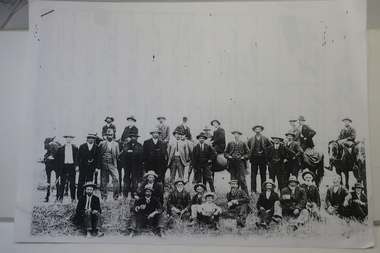 Kiewa Valley Historical Society
Papers photocopied - photo, list of names, Kiewa Valley Pioneers and Early Activities on the Bogong High Plains
... Department of Crown Lands letter - 1841 Tawonga pastoral run - Mr James Roberts and Mullindollingong pastoral run 1846 - Mr Patrick Reynolds 3. An account of the Bogong High Plains by W. ...Department of Crown Lands letter - 1841 Tawonga pastoral run - Mr James Roberts and Mullindollingong pastoral run 1846 - Mr Patrick Reynolds 3. An account of the Bogong High Plains by W. ...All Early History of the Kiewa Valley. 1. Photo clear but no date. Men named and are residents selecting a site for a bridge at Keegans Crossing 2. Department of Crown Lands letter - 1841 Tawonga pastoral run - Mr James Roberts and Mullindollingong pastoral run 1846 - Mr Patrick Reynolds 3. An account of the Bogong High Plains by W. F. Waters from the late 1890s to 1930s. Published article in the Schuss magazine. August 1958 History of Keegan's Crossing, Kiewa Valley and surrounding residents with names and photos. Early pastoral runs in the Kiewa Valley and Early activities on the Bogong High Plalns..1.The photo includes a listing of residents selecting a site for a bridge at Keegans Crossing. 2. A letter from the Department of Victorian Lands and Survey re early settlers 3. History written in Schuss magaine, Aug. 1958. "In 1896 ... erection of snow poles from Rocky Valley to Tawonga Hut. keegan's crossing, w.f. waters, tawonga and mullindollongong pastoral runs -
Federation University Historical Collection
Booklet, Burials with Irish Locations in the Ballarat Old and New Cemetaries
... Reynolds...Ireland...Irish...Eureka Burials...Hugh Brady...Robert...Barker Library (top floor) Mount Helen goldfields Ballarat Old Cemetary Ballarat New Cemetary Gwen Dixon Joy Menhennet Lois Reynolds Ireland Irish Eureka Burials Hugh Brady Robert Bell Mary Berkery James Brown Dennis Callinan Honora Callinan Mary Diamond John Diamond John Donaghey Patrick Dunne Mary Anne Dunne Ann Fitzgerald Patrick Gittens Michael Hanrahan John Hines Richard James Hobson Hugh Lamb Patrick Linnane Patrick Laffey Edwd McGlyn Thadds More Thomas Mullin Thomas O'Neill Edward Quin William Walsh John Walsh Mary Walker Michael Saxton Ann Ryan Abigail Harland McCann Margaret Lannan Thomas Dinneny John Commons Edmond Bourke John Barycery Thomas Bury Father Michael Jones Rev. ...A5 booklet with green cover containing the names of people with Irish backgrounds buried in the Old and New Ballarat Cemetries ballarat old cemetary, ballarat new cemetary, gwen dixon, joy menhennet, lois reynolds, ireland, irish, eureka burials, hugh brady, robert bell, mary berkery, james brown, dennis callinan, honora callinan, mary diamond, john diamond, john donaghey, patrick dunne, mary anne dunne, ann fitzgerald, patrick gittens, michael hanrahan, john hines, richard james hobson, hugh lamb, patrick linnane, patrick laffey, edwd mcglyn, thadds more, thomas mullin, thomas o'neill, edward quin, william walsh, john walsh, mary walker, michael saxton, ann ryan, abigail harland mccann, margaret lannan, thomas dinneny, john commons, edmond bourke, john barycery, thomas bury, father michael jones, rev. t.p. lynch, michael mcguane, john canny, timothy madden, bridget madden, thomas shanahan, john shanahan, margaret shanahan, margaret wulff, michael sweeney, timothy sweeney -
Federation University Historical Collection
Booklet, Victorian Department of Youth, Sport and Recreation, Life. Be In it. Health and Fitness, c1980s
... Anderson j. hopley m. reynolds a. roberts Ballarat College of Advanced Education lecturer Peter Fryar and others listed on page 43 A book of initiratives to increas health and fitness. ...Ballarat College of Advanced Education lecturer Peter Fryar and others listed on page 43A book of initiratives to increas health and fitness.non-fictionBallarat College of Advanced Education lecturer Peter Fryar and others listed on page 43health, fitness, recreation, peter fryar, clem barnett, i. anderson, j. hopley, m. reynolds, a. roberts -
 Orbost & District Historical Society
account, 13th May, 1915
... Reynolds. Swan was a tinsmith, coppersmith, plumber, zinc and iron worker who specialised in repairing tanks. Robert...Reynolds. Swan was a tinsmith, coppersmith, plumber, zinc and iron worker who specialised in repairing tanks. Robert ...E. Swan (of Bairnsdale) purchased the Orbost Tank Factory from Mr E. F. Reynolds. Swan was a tinsmith, coppersmith, plumber, zinc and iron worker who specialised in repairing tanks. Robert Pullar Cameron was a Shire Councillor for many years. He married Penuel Hossack and had a family of James, Flora, Penuel and Alex.This item is an example of the book-keeping of an Orbost business in the early 20th century and is a useful research tool.A very stained shite paper account with black print and red lines from E. Swan, Orbost Tank Factory, to R. Cameron.swan-e. cameron-robert-pullar -
 Orbost & District Historical Society
account, 1910
... Reynolds. In about 1905 Mr Drevermann assumed proprietorship and the tinsmith and plumbing section of the business was sold off to Mr Edward Swan. The ironmongery, hardware and timber business was known as Carl Dreverman & Co until 1917 when it was changed to Orbost Hardware and Timber Co. This shop had a row of nails on the window sill to prevent people sitting on the ledge. Robert...Reynolds. In about 1905 Mr Drevermann assumed proprietorship and the tinsmith and plumbing section of the business was sold off to Mr Edward Swan. The ironmongery, hardware and timber business was known as Carl Dreverman & Co until 1917 when it was changed to Orbost Hardware and Timber Co. This shop had a row of nails on the window sill to prevent people sitting on the ledge. Robert ...Mr Carl Otto (Clyde) Drevermann was born at Lucknow and worked in various parts of Victoria before coming to Orbost in about 1902. In July 1902 he entered into partnership with Mr Edward Fisher Reynolds and the ironmongery, hardware and tinsmithing business was carried on by the new firm as Drevermann and Reynolds. In about 1905 Mr Drevermann assumed proprietorship and the tinsmith and plumbing section of the business was sold off to Mr Edward Swan. The ironmongery, hardware and timber business was known as Carl Dreverman & Co until 1917 when it was changed to Orbost Hardware and Timber Co. This shop had a row of nails on the window sill to prevent people sitting on the ledge. Robert Pullar Cameron was a Shire Councillor for many years. He married Penuel Hossack and had a family of James, Flora, Penuel and Alex.This item is an example of the book-keeping of an early 20th century Orbost business and is a useful research tool. A white paper account with red lines and black print. Details are hand-written. It is from Carl Drevermann, Furnishings and General Ironmongers, to R. Cameron. -
 Federation University Historical Collection
Booklet, Ballarat Teachers College, Emerald Jubilee Reunion, 1949 - 2004, 2004
... Barker Library (top floor) Mount Helen goldfields emerald jubilee reunion Ballarat Teachers' College Programme Lois Bilston Waters Sherryn Waters Baile Ines Bourke Noone Kath Bunworth Drummond Jean Clarke White Stan White Margaret Collins Mountford Frank Mountford Mavis Court Blackie Margaret Eveston Peters Carmel Fitzgerald Ryan Mary Gallagher Edmonds Ruth Gardy Howard Mary Gearing Turner Margaret George Freckleton Maureen Godfrey Fithall Rose Harrison Johnstone Norma Heinrich Boldiston Bill Boldiston Margaret Hives Coughlan John Coughlan Pam Hudson Pentney Valda Kelly Spalding Kingsley Spalding Nancy Lee Sedgewick Lesley Latch Frank Verna Lees Kaye Kathy Lister Kenna Isabel MacMahon Young Kitty O'Shannessy McGurrin Janet Page Sanders George Sanders Margaret Panther Leask Margaret Reynolds Bennett Shirley Russell Rae Pat Ryan Roberts Betty Webb McGuane Ilysa Witney Robertson Wall Baker Beryl Baker Graham Bartle Ruth Bartle Max Bridges Dorothy Bridges Lindsay Campbell David Collins Jan Collins Jim Dunn Ron Edmonds Don Evans Jean Evans George Fordham Janice Fordham Peter Fryar Bev Hill John Holloway Judy Holloway Jim Lannen Florence Lannen Bill Lister Betty Lister Ian McIntyre Carol McIntyre Len McRae Vans McRae Keith Richardson Vera Richardson Ian Ryan Neil Tippett Wal Wall Rosemary Wall Valda Ward Gold and blue ribbon taped to front cover Small 8 page booklet from the Ballarat Teachers' College Reunion 2004 Ballarat Teachers College, Emerald Jubilee Reunion, 1949 - 2004 Booklet ...Small 8 page booklet from the Ballarat Teachers' College Reunion 2004Gold and blue ribbon taped to front coveremerald, jubilee, reunion, ballarat teachers' college, programme, lois bilston waters, sherryn waters baile, ines bourke noone, kath bunworth drummond, jean clarke white, stan white, margaret collins mountford, frank mountford, mavis court blackie, margaret eveston peters, carmel fitzgerald ryan, mary gallagher edmonds, ruth gardy howard, mary gearing turner, margaret george freckleton, maureen godfrey fithall, rose harrison johnstone, norma heinrich boldiston, bill boldiston, margaret hives coughlan, john coughlan, pam hudson pentney, valda kelly spalding, kingsley spalding, nancy lee sedgewick, lesley latch frank, verna lees kaye, kathy lister kenna, isabel macmahon young, kitty o'shannessy mcgurrin, janet page sanders, george sanders, margaret panther leask, margaret reynolds bennett, shirley russell rae, pat ryan roberts, betty webb mcguane, ilysa witney robertson, wall baker, beryl baker, graham bartle, ruth bartle, max bridges, dorothy bridges, lindsay campbell, david collins, jan collins, jim dunn, ron edmonds, don evans, jean evans, george fordham, janice fordham, peter fryar, bev hill, john holloway, judy holloway, jim lannen, florence lannen, bill lister, betty lister, ian mcintyre, carol mcintyre, len mcrae, vans mcrae, keith richardson, vera richardson, ian ryan, neil tippett, wal wall, rosemary wall, valda ward -
Federation University Historical Collection
Book, Education Department Certificates 1908 - 1922
... Robert Gullan...Henry Bull...Clara Clegg...John David...Albert Ferguson...Ina Westcott...Vera Walker...Agnes Walker...Eileen Tremain...Florence Smith...Lizzie Pier...Annie Reynolds...Barker Library (top floor) Mount Helen goldfields School of Mines Ballarat was a predecessor of Federation University Education Department School of Mines Ballarat Leslie Bennett Eulali Perry Hector Osborne Doris McDougall Mary Mullins John McLean Mary Morrish Francis Kelly Robert Gullan Henry Bull Clara Clegg John David Albert Ferguson Ina Westcott Vera Walker Agnes Walker Eileen Tremain Florence Smith Lizzie Pier Annie Reynolds Charles Peverill William Pearson Doris Patterson Rebecca McPhan Constance McHenry Jean McGregor Florence Mingst Gwen Mann Roz Kelly Edward Jones Freddi Jacobi Percy Baker Doris Carter Stephen Chambers Ruth Catt Arthur Dousey D'Arcy Bessie Doncaster Alan Eggleston Lena Featherstone Clarice Fisher Sylvia Williams James Walker Annie Treloar Shearer Cora Sandberg Elsie Pearce Jan McGregor Cyril McGibbon Margaret Moore Thomas Kierce William James Alice Horan Lucy Hamilton Beatrice Blake Catherine Bowers Mona Callow Lillian Cameron Joyce Dopel Iva Denovan William Thompson Irene Hewitt Catheriine Kardens Beatrice Stuart Hugh Ross Mavis Regelhuth Isabelle Bell Melba Perriman Vera Muny Alan Bernaldo Kathleen Conway Dorothy Darling Walter Dunston Mary Dwyer Agnes Fraser Enid Gates Maude Williams Violet Wheeler Jean Tunbridge Maud Auberry John B. ...School of Mines Ballarat was a predecessor of Federation UniversityBlack cloth covered book with handwritten pages and loose foolscap pages at the front and sticer on front cover with CERTIFICATES written on it.education department, school of mines ballarat, leslie bennett, eulali perry, hector osborne, doris mcdougall, mary mullins, john mclean, mary morrish, francis kelly, robert gullan, henry bull, clara clegg, john david, albert ferguson, ina westcott, vera walker, agnes walker, eileen tremain, florence smith, lizzie pier, annie reynolds, charles peverill, william pearson, doris patterson, rebecca mcphan, constance mchenry, jean mcgregor, florence mingst, gwen mann, roz kelly, edward jones, freddi jacobi, percy baker, doris carter, stephen chambers, ruth catt, arthur dousey, d'arcy, bessie doncaster, alan eggleston, lena featherstone, clarice fisher, sylvia williams, james walker, annie treloar, shearer, cora sandberg, elsie pearce, jan mcgregor, cyril mcgibbon, margaret moore, thomas kierce, william james, alice horan, lucy hamilton, beatrice blake, catherine bowers, mona callow, lillian cameron, joyce dopel, iva denovan, william thompson, irene hewitt, catheriine kardens, beatrice stuart, hugh ross, mavis regelhuth, isabelle bell, melba perriman, vera muny, alan bernaldo, kathleen conway, dorothy darling, walter dunston, mary dwyer, agnes fraser, enid gates, maude williams, violet wheeler, jean tunbridge, maud auberry, john b. allen, rose c. andrews, willie banagwanath, john n. bennett, alfred bayley, geo h. blake, ida bolte, allison brown, eva brown, harold r. brown, henry f. bull, arthur burge, olive cotton, gertrude f coxon, alice culph, curtain, r.l. cutter, florence davis, w.m davies, helen dempster, ed dopel, l.c.m. dovey, ernest duncan, hugh elliott, nelson h. ferguson, mary featherstone, amelia field, david cochrane, phyllis polson, frederick proctor, geoff richards, bessie robertson, catherine ronald, cora saudberg, mary sheppard, scott smith, leonard steele, j.b. suttcliffe, nellie thornhill, vernon fisher, gordon fletcher, elsie ford, constance furness, grace m. geddes, ada giacometti, mary gleeson, v. hall, harold herm, dorothy hambley, clemence hill, evelyn hodgson, annie holmes, glynis humphreys, augus henderson, joseph james, queenie johnson, harold jolly, francis n. king, william knott, mary kinnear, adelaide leash, doris lonie, a lilbourne, f.j. llewellyn, herb malui, muriel mathew, nellie moloney, mabel morris, ernest morshead, w.k. moss, winifred moyley, eileen mcinerney, jack mclean, chas mcnamara, maryanne medwell, alice osbourne, elsie pitts, percy trompf, basil tunbridge, david walker, ruby walton, annie whitla, kenneth whittle, walter wilberforce, alb e williams, masie wise, amy wolff, olive wunhym, beryl atkins, hector ashby, geo banagwanath, g.n.j. barker, marion r. bailey, kathleen bowe, lelia brough, cecil campbell, basil craddock, ida chapman, iris campbell, una campbell, eileen cleary, reg m.l. cuttter, lyle eves, violet elston, eric embling, violet evans, f.l. ellsworth, vera fisher, una fowles, colin graham, victor greenhalgh, clarence grose, dororthy hall, margaret hannaby, leslie henderson, harold herbert, effie holmes, herbert hopkins