Showing 37 items matching "rock pool"
-
 University of Melbourne, Burnley Campus Archives
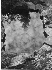
Photograph - Black and white print, E.M. Gibson, Rock Pool, March/April 1947
... Rock Pool......rock pool...Looking down into a rock pool surrounded by rocks. Built by the Commonwealth Reconstruction Training Scheme students behind the Dairy....The rock pool was constructed by 1st Short Course (CRTS) under guidance of Mrs. ...crts e. m. gibson e. m. gibson collection rock pool commonwealth reconstruction training scheme students cacti dairy The rock pool was constructed by 1st Short Course (CRTS) under guidance of Mrs. ...Black and white photograph. Looking down into a rock pool surrounded by rocks. Built by the Commonwealth Reconstruction Training Scheme students behind the Dairy.The rock pool was constructed by 1st Short Course (CRTS) under guidance of Mrs. E. M. Gibson." E M Gibson 6/4crts, e. m. gibson, e. m. gibson collection, rock pool, commonwealth reconstruction training scheme students, cacti, dairy -
 Stawell Historical Society Inc
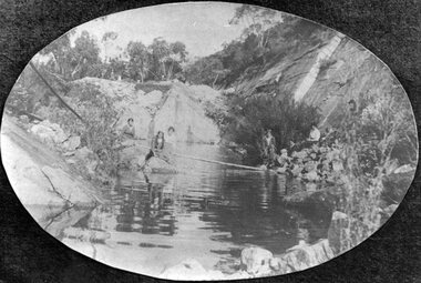
Photograph, Heatherlie Quarry with people around a rock pool
... Heatherlie Quarry with people around a rock pool....Many people around a rock pool....Black and White Photo - Mountain Scene. many people around a rock pool. Oval Shaped photo in black background....Many people around a rock pool. Stawell Grampians Industry Black and White Photo - Mountain Scene. many people around a rock pool. ...Heatherlie Quarry. B/W photo Mountain Scene. Many people around a rock pool.Black and White Photo - Mountain Scene. many people around a rock pool. Oval Shaped photo in black background.stawell grampians industry -
 Kew Historical Society Inc
Photograph - Deep Rock Swimming Pool and Clubrooms on the Yarra, c.1925
... Deep Rock Swimming Pool and Clubrooms on the Yarra...Deep rock swimming pool...The former Deep Rock Swimming Pool was about 500 yards [457 metres] above Dight’s Falls. ...Small, faded, Gelatin Silver print positive photograph of the Deep Rock Swimming Pool situated on the Yarra at Collingwood and Fairfield. ...Kew Historical Society Inc Kew Court House 188 High Street Kew melbourne The former Deep Rock Swimming Pool was about 500 yards [457 metres] above Dight’s Falls. ...The former Deep Rock Swimming Pool was about 500 yards [457 metres] above Dight’s Falls. It was there that the Deep Rock Swimming Club was established in 1906. This initial club was expanded in 1916 to incorporate a life-saving club. In 1918, John Wren, the president of the club offered the club £1000, and undertook to sponsor a patriotic carnival in March 1918, at which swimming champions would take part. The ‘pool’ was to achieve fame as the venue for a world record-breaking ‘swallow dive’ of 205 feet 9 inches [63 metres] by ‘Prince Wickyama’, [aka Alec Wickham], a Solomon Islander. The dive from a special platform on the west side of the Yarra was reputedly viewed by between 50,000-100,000 spectators, with funds going to the State War Council. The Herald, 25 March 1918, claimed that the wide area occupied by spectators made more precise estimates impossible. In the 1980s, the construction of the Eastern Freeway, and the consequent re-routing of the Yarra River led to the site of the Deep Rock Pool being obliterated. A small cairn and plaque on the Fairfield side of the river now marks its former site.Very rare early photograph off the Deep Rock swimming pool. The pool and its built structures are historically and socially important to the people of Collingwood, Fairfield and Kew. Small, faded, Gelatin Silver print positive photograph of the Deep Rock Swimming Pool situated on the Yarra at Collingwood and Fairfield. The famous diving tower is at the right of the photo. The built structures were constructed for the Deep Rock Swimming and Life Saving Club. People are sitting on the terraces above the river. "Bathing Club. Deep Rock on the Yarra. Studley Park Melbourne. Please credit E.J. Thomasson Collection"deep rock swimming pool, deep rock swimming club, deep rock lifesaving club, swimming -- river yarra, river yarra -
 Federation University Art Collection
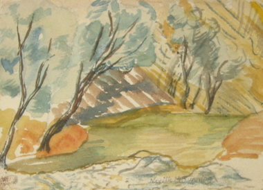
Artwork - Painting, 'Rock Pool Flinders Ranges' by Neville Bunning
... 'Rock Pool Flinders Ranges' by Neville Bunning...The Art Collection features over 1000 works and was listed as a 'Ballarat Treasure' in 2007. neville bunning available landscape artwork artist LR Neville M Bunning signature in pencil small framed painting of trees in a landscape 'Rock Pool Flinders Ranges' by Neville Bunning Artwork - Painting Neville Bunning Neville Bunning ...Neville Mirvane BUNNING (1902-1990) During World War Two he served with the RAAF. He was an Art Teacher at the Ballarat School of Mines from 05 February 1946 to 22 September 1964. Neville Bunning formed the Ballarat Artist's Society (later the Ballarat Society of Artists), a group that sponsored art and which invited modernist artists to speak to students and to the public of Ballarat. He also wrote a weekly column in the Ballarat Courier. Bunning produced a bust of Australian Prime Minister, The Right Honourable J.A. Lyons from Tasmania, who died in office. Bunning died in Subiaco, Western Australia on 29 April 1990. This item is part of the Federation University Art Collection. The Art Collection features over 1000 works and was listed as a 'Ballarat Treasure' in 2007.small framed painting of trees in a landscapeLR Neville M Bunning signature in pencilneville bunning, available, landscape, artwork, artist -
 Whitehorse Historical Society Inc.
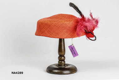
Headwear - Hat, c. 2000
... Rock Pool Millinery...Her name was Roberta, daughter of Mary and Geoff Eastern, purchased from Harris Scarfe, Forest Hill 1990. costume female headwear Rock Pool Millinery Red Pill Box Straw Hat, decorated with red feathers, black beads and crystal beads, with black comb to hold in the hair. ...Purchased in Sorrento from shop whose owner grew up at 10 Burnett Street, Mitcham. Her name was Roberta, daughter of Mary and Geoff Eastern, purchased from Harris Scarfe, Forest Hill 1990.Red Pill Box Straw Hat, decorated with red feathers, black beads and crystal beads, with black comb to hold in the hair.Rock Pool Millinerycostume, female headwear -
 Lakes Entrance Historical Society
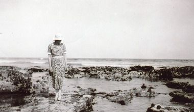
Photograph - Harbeck Family 1935
... Black and white photograph of a female member of the Harbeck family standing beside a rock pool at a coastal location...Genealogy Harbeck Black and white photograph of a female member of the Harbeck family standing beside a rock pool at a coastal location Photograph Harbeck Family 1935 ...Black and white photograph of a female member of the Harbeck family standing beside a rock pool at a coastal locationgenealogy, harbeck -
 Kew Historical Society Inc
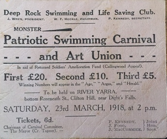
Flyer, Deep Rock Swimming and Lifesaving Club, Monster Patriotic Swimming Carnival and Art Union, 1918
... ...deep rock pool...Numerous items in the collection are historically important in that they are rare and often unique records of vanished locations or past recreational activities. christian-washfold collection river yarra -- recreation yarra - swimming carnivals deep rock pool Advertisement or ticket to a Monster Swimming Carnival to be held by the Deep Rock Swimming and Lifesaving Club in Fairfield at the bottom of Roseneath Street on Saturday 23rd March 1918 at 2 p.m. ...An item of ephemera relating to tourism and recreation on the Yarra River in Melbourne in the first half of the twentieth century.An item from a large collection assembled by the Christian and Washfold families of Kew, including photographs, postcards, and ephemera. Many of the items in the Christian-Washfold Collection relate to the Yarra River and its use as as a recreational resource. Numerous items in the collection are historically important in that they are rare and often unique records of vanished locations or past recreational activities.Advertisement or ticket to a Monster Swimming Carnival to be held by the Deep Rock Swimming and Lifesaving Club in Fairfield at the bottom of Roseneath Street on Saturday 23rd March 1918 at 2 p.m.christian-washfold collection, river yarra -- recreation, yarra - swimming carnivals, deep rock pool -
 Tatura Irrigation & Wartime Camps Museum
Photograph, 1950
... Murchison Camp 13 - P.O.W chapel on right, house left of centre, rock pool in foreground with concrete fountain...Murchison Camp 13 - P.O.W chapel on right, house left of centre, rock pool in foreground with concrete fountain Photograph ...Taken by photographer for State Rivers and Water Supply Commission.Medium sized black and white photograph. Murchison Camp 13 - P.O.W chapel on right, house left of centre, rock pool in foreground with concrete fountainvictorian state rivers and supply commission, camp 13, murchison, water commission camp -
 Federation University Historical Collection
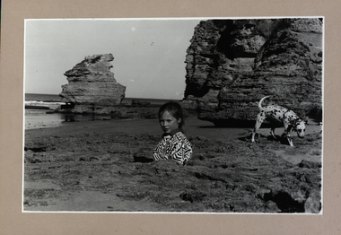
Photograph - Photograph - Black and White, Point Lonsdale Back Beach below the Lighthouse - Girl with a Dog
... Black and white photograph adhered to a beige coloured mount card showing a girl down a hole in the sand with her dalmation dog sitting in a rock pool....A Pilot Station was established and ship captains could signal for a Pilot to steer them through The Rip and into Port Philip Bay. paul lambeth point lonsdale back beach sailing ships ship wrecks the rip port philip bay pilot station girl dalmation dog Black and white photograph adhered to a beige coloured mount card showing a girl down a hole in the sand with her dalmation dog sitting in a rock pool. Point Lonsdale Back Beach below the Lighthouse - Girl with a Dog Photograph Photograph - Black and White ...Work produced during Paul Lambeth's photography class The photograph shows the back beach at Point Lonsdale, below the Point Lonsdale Lighthouse. This area was where many sailing ship coming to Melbourne were wrecked. This was due to the narrow passage through The Rip and the tides at certain times. A Pilot Station was established and ship captains could signal for a Pilot to steer them through The Rip and into Port Philip Bay. Black and white photograph adhered to a beige coloured mount card showing a girl down a hole in the sand with her dalmation dog sitting in a rock pool.paul lambeth, point lonsdale, back beach, sailing ships, ship wrecks, the rip, port philip bay, pilot station, girl, dalmation dog -
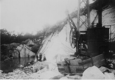
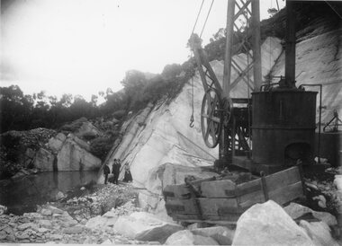 Stawell Historical Society Inc
Photograph, Picknickers outing at Heatherlie Quarry in the Mt Difficult Area, c 1914 -18
... Machinery near a rock pool. Three men and a lady...Machinery near a rock pool. Three men and a lady Stawell Grampians Industry Black and White Photgraph in a quarry with machinery in foreground and a group of people of in the distance. ...Picnic outing at Heatherlie Quarry Mt Difficult Area. Machinery near a rock pool. Three men and a ladyBlack and White Photgraph in a quarry with machinery in foreground and a group of people of in the distance.stawell grampians industry -
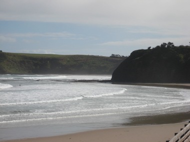 Ballarat Heritage Services
Photograph - Photograph - Colour, Smith's Beach, 2011, 29/08/2017
... Known for surfing, swimming, rock pooling, and family-friendly vibes with amenities like cafes and resorts. ...Known for surfing, swimming, rock pooling, and family-friendly vibes with amenities like cafes and resorts. ...Smiths Beach is a popular coastal spots in Phillip Island, Victoria. Known for surfing, swimming, rock pooling, and family-friendly vibes with amenities like cafes and resorts. The Phillip Island location offers consistent waves for all levels.Colour photographs of Smith's Beach.smith's beach, sea, beach, phillip island -
 Stawell Historical Society Inc
Photograph, Heatherlie Quarry with crane on right and cut blocks at bottom of cliff face
... Third photo is different but given the man's clothing, he possibly was on the excursion. as were the people at the rock pool in 213-1...Third photo is different but given the man's clothing, he possibly was on the excursion. as were the people at the rock pool in 213-1 Heatherlie Quarry with crane on right and cut blocks at bottom of cliff face Photograph ...Heatherlie Quarry. Black and white Photograph of Heatherlie Quarry with crane on right and cut blocks at bottom of cliff face. One small original and one enlargement. On the back of the small photo Quarries train escursion 1920. Third photo is different but given the man's clothing, he possibly was on the excursion. as were the people at the rock pool in 213-1stawell grampians industry -
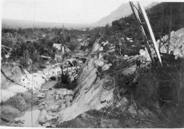
 Halls Gap & Grampians Historical Society
Photograph - B/W, C 1902
... Shows equipment working rock-face with pool of water in foreground...Shows equipment working rock-face with pool of water in foreground Photograph B/W ...Heatherlie Quarry. . Shows equipment working rock-face with pool of water in foreground'From the Weekly Times, September 1902" written on backquarrying, mt difficult quarry -
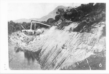
 Halls Gap & Grampians Historical Society
Photograph - B/W, C 1900s
... Three men & a woman standing in front of rock wall. Pool of water middle left...Three men & a woman standing in front of rock wall. Pool of water middle left Photograph B/W ...Heatherlie quarry - Photo shows a large piece of equipment front right. Three men & a woman standing in front of rock wall. Pool of water middle leftquarrying, mt difficult quarry -
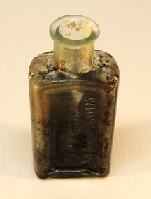 Torquay and District Historical Society
Container - Bottle, Shoe polish
... Probably from the wreck of the Joseph H Scammell as it was found in a rock pool at low tide at Point Danger, where the Scammell was shipwrecked. ...Probably from the wreck of the Joseph H Scammell as it was found in a rock pool at low tide at Point Danger, where the Scammell was shipwrecked. ...Probably from the wreck of the Joseph H Scammell as it was found in a rock pool at low tide at Point Danger, where the Scammell was shipwrecked. The Joseph H Scammell was a Canadian sailing ship that was wrecked off Point Danger, adjacent to the township of Torquay, on the 7th May 1891 on a voyage from New York to Melbourne with a general cargo worth $120,000 No lives were lost. Captain John albert Chapman was suspended as a ships master for 12 months. Whittemore Brothers Company was a large producer of shoe polish in Cambridge, Massachusetts, USA, between 1852 and the 1930s.Small bottle, aqua in colour, containing traces of shoe polish and embossed with the maker "Whittemore". A cork stopper has been added later.Whittemore/Boston/USAshipwrecks great ocean road victoria, scammell collection -
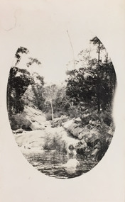 Kew Historical Society Inc
Photograph - Grampians, 1924
... This photo is of a rock pool, developed within an oval framing device....This photo is of a rock pool, developed within an oval framing device. ...Henry Beater Christian (1886-1962) , was a descendant of one of the earliest settler families in Kew. Employed at the Kew Asylum as a 'public servant', he was a skilled amateur photographer, photographing numerous scenes in Kew and on his travels around Victoria. The majority of his photographs date from 1916 to 1929. His finest photographs are housed in two photograph albums. Digital copy of a photograph from page 14 of the 47-page photograph album containing 261 gelatinous silver images, loaned by Diane Washfold with permission given to digitise and hold a copy in our collection. The first and last pages in the album document the Yarra River at Studley Park and at Kew. The remainder of the album includes photographs of walking and car tours in rural Victoria including 'wilderness' areas in the Grampians, Gippsland and the High Country. Six album pages document a camping trip by Henry Christian to the Grampians in September 1924. The photos include pictures of lookouts, and natural features including rock faces and waterfalls, as well as his camp site. This photo is of a rock pool, developed within an oval framing device."Grampians"henry beater christian (1886-1962), landscape photography, christian-washfold collection, photograph albums, grampians, gariwerd -
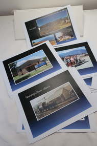 Kiewa Valley Historical Society
Coloured photographs on paper - Back to Tawonga 2010
... Saw Mill - Mill house 2. The Rock Pool 3. People at the Rock Pool x 2 4.Old Saw mill 5. ...Saw Mill - Mill house 2. The Rock Pool 3. People at the Rock Pool x 2 4.Old Saw mill 5. ...These photos were collected and copied by Di Edmondson for the 'Back To Tawonga' Event in 2010 when she launched her book "Tawonga Remembers".An historical photographic collection of Tawonga and its surrounds, places and people up to 20101. Saw Mill - Mill house 2. The Rock Pool 3. People at the Rock Pool x 2 4.Old Saw mill 5. Back to Tawonga Celebrations x6 6. Tennis Curts opposite the Tawonga Store, Bakery in the background 7. Bowling Club 8. Old Guide Hall 9. The Old Boarding House 10. Old Fire Brigade Shed 11. Building the New Tawonga Memorial Hall 12. Tawonga Go Kart Track - 1960s 13. Tawonga Pony Club 1969 State Championships 14. Tawonga Recreation Reserve Newspaper article 15. The Damm Children 19. 1980s Brian Edmondson, Geoff Edmondson, Mick Harvey, David Piera. Geoff Edmondson's car 20. Tawonga Speedway Track - 1970s Mick Harvey and Paul Harkin's car 21. 2000 22. Tawonga Sports Vera Ryder and Allie Briggs 23. Tawonga School Photos x8 24. Harry Cooper's Farm Looking South 25.View from Edmondson's Farm - looking north 26. Mount Emu 27. St Aiden's Debutante Ball 27. Grand Opening Ball 1961 Tawonga Hall 28. The Kiewa Valley Road at Tawonga. Vic. 29. Tennis Courts opposite the Bogong Hotel 30.Opening of the new Toilet Block in Pioneer park 31. Old Tawonga Store x 3 32. Tawonga Memorial Hall 33. Anglican Church, St Aiden's x 2 34. Motor Khana held at Recreation reserve 35. 1970 State Champioships Team 36. Kiewa Valley School Sports at Dederang 37. Miscellaneous photos x27 Some photos have headings and some headings have been writtentawonga remembers, back to tawonga 2010, di edmondson -
 Phillip Island and District Historical Society Inc.
Photograph - Photographs of Phillip Island, 1920s and 1940s
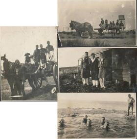
... Photograph of 5 boys and 1 woman swimming in rock pool. 1 boy watching. 314-05. Photograph of old wooden hut with tank and chimney. ...Photograph of 5 boys and 1 woman swimming in rock pool. 1 boy watching. 314-05. Photograph of old wooden hut with tank and chimney. ...Photographs associated with Public Schools camp, that started in the 1930s. Some boys worked on chicory at McFee's farm. 314-05 was possibly located at Trenavin Farm, Ventnor. (Source Jan Andrews ) Photo of people on cart with tank stand was off to a 7 picnic at the Nobbies 1917. [See 1124-01] Keeston Sambell driving, behind him is Betty Parker. on side from left is May Lambert, Jim Patterson, Jim Blake, Carmen Sambell and Bill Sambell.[ Source Jim Blake] Eight black & white photographs. 314-01. Photograph of horse and cart with 2 women, 2 girls and 5 boys. 314-02. Photograph of a mixed group of 7 people on a horse and drag. 314-03. Photograph of 3 young adult males and a dog standing in front of a wooden building. 1926 “Campers Rest” Labelled The Immortal camp at Ventnor. Poss. Trenavin Park 314-04. Photograph of 5 boys and 1 woman swimming in rock pool. 1 boy watching. 314-05. Photograph of old wooden hut with tank and chimney. Appears to have been used by boys when camping. 314-06. Photograph of 4 boys - 2 in swimming costumes - on the beach. 314-07. Photograph of 3 women and 1 girl sitting on sand dunes. 314-08. Photograph of 3 boys in uniform and 1 man sitting on bench - maybe watching sporting event?scotch college camp phillip island, scotch college boys, s j mcfee, c.k. newman, f. r. newman, trenavin park phillip island, sambell family, jim blake, betty parker -
Marysville & District Historical Society
THE TRIANGLE NEWS-VOL 38 NO 5-FEBRUARY 18 2010
... ...pool party to rock alexandra...Marysville & District Historical Society 39 Darwin Street Marysville yarra-valley-and-the-dandenong-ranges marysville victoria australia pool party to rock alexandra marysville triangle twilight bus service THE TRIANGLE NEWS-VOL 38 NO 5-FEBRUARY 18 2010 ...marysville, victoria, australia, pool party to rock alexandra, marysville triangle twilight bus service -
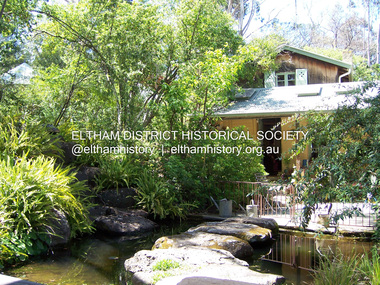 Eltham District Historical Society Inc
Photograph - Digital Photograph, Marguerite Marshall, Gordon Ford's Garden, 'Fulling', Pitt Street, Eltham, 10 November 2006
... Retaining walls and steps of rock through the garden link different terrace levels. Lichen-covered boulders serve as steps across a pool, leading to the triple level mud-brick house. ...Retaining walls and steps of rock through the garden link different terrace levels. Lichen-covered boulders serve as steps across a pool, leading to the triple level mud-brick house. ...'Fulling', the half-hectare property at Pitt Street, Eltham was the home of landscape designer Gordon Ford and his wife Gwen. Ford bought the property in 1948, originally part of an orchard. The garden encapsulates the major trends of Australian garden design in the second half of the 20th century. The garden design is based on mass (plants) and void (paths and pools), textures and forms. It epitomises the Eltham style because of its relaxed informality and attraction to native wildlife. The mud brick house and designed and built by Ford commenced in 1948. Several extensions were added up to 1970 and were built by Graham Rose (Source: information panel for exhibition, n.d.) Covered under Heritage Overlay, Nillumbik Planning Scheme. Published: Nillumbik Now and Then / Marguerite Marshall 2008; photographs Alan King with Marguerite Marshall.; p147 A narrow timber gate opens onto a garden that has had a huge impact on natural garden development in Australia since the 1950s.1 Fulling, the half-hectare property at Pitt St, Eltham, was the home of the landscape designer, Gordon Ford, who died in 1999. The garden ‘encapsulates the major trends of Australian garden design in the second half of the 20th century...and epitomises the Eltham style of garden’.2 It in turn, was influenced by several Victorian major landscape designers of the mid 20th century – Ellis Stones, Peter Glass and Edna Walling. The gate opens onto a sandy gravel path, one of several, which wind around dramatic pools and what appear to be natural bush, but on close inspection are carefully integrated native, indigenous and exotic plantings. Retaining walls and steps of rock through the garden link different terrace levels. Lichen-covered boulders serve as steps across a pool, leading to the triple level mud-brick house. Ford bought the property, which was originally part of an orchard, in 1948. As the son of a Presbyterian minister, Ford received a good education, which included learning Latin. This was advantageous when he worked in plant sales for the Forestry Commission, before the Second World War. In the late 1940s, however, Ford turned to building and landscape gardening. He worked on the Busst house, an early mud-brick building designed by Alistair Knox and at the same time, Ford was employed by Ellis Stones. Knox described Ford as, ‘one of the funniest men of the district. ...Rocky’s (Ellis Stones) Depression stories and Gordon’s memory and quick tongue made the jobs the most enjoyable of all those hysterical times that made Eltham the centre of the eternal laugh, between the years of 1945 and 1950’.3 Ford’s house, like so many after the war, was built progressively, as more space was needed and formerly scarce materials became available. It began with an army-shed of timber-lined walls, now used as the kitchen. Ford then built what is now the lounge room, and the house grew ‘like topsy and on a shoestring,’ says his widow Gwen. A lot of second-hand materials such as window frames were used, a style made famous particularly with their extensive use at Montsalvat, the Eltham Artists’ Colony. The house was constructed as a joint venture with friends, including artist Clifton Pugh, who built Ford’s bedroom for £10. The polished floorboards and solomite (compressed straw) ceilings, interspersed with heavy beams, exude warmth. The result is a home of snug spaces, with soft light and garden vistas. Several other mud-brick buildings were constructed as needed, including a studio and units for bed-and-breakfast clients. The garden, which has been part of the Open Garden Scheme since the mid 1980s, is based on a balance of mass (plants) and void (paths and pools), textures and forms. It epitomises the Eltham style because of its relaxed informal ethos and attracts native animals. Wattlebirds, scrub wrens, pardalotes, currawongs, owls and even kangaroos, have been seen at Fulling. Gwen, a former English teacher who has worked on the garden since around 1970, urged and helped Ford write his book, The Natural Australian Garden.4 Several of Ford’s favourite trees are in the garden, including the native Casuarina or She-Oak. In spring, the garden is dusted with the purple Orthrosanthus multiflorus or blue native irises and rings with the calls of birds attracted to plants like the callistemons, correas and grevilleas.This collection of almost 130 photos about places and people within the Shire of Nillumbik, an urban and rural municipality in Melbourne's north, contributes to an understanding of the history of the Shire. Published in 2008 immediately prior to the Black Saturday bushfires of February 7, 2009, it documents sites that were impacted, and in some cases destroyed by the fires. It includes photographs taken especially for the publication, creating a unique time capsule representing the Shire in the early 21st century. It remains the most recent comprehenesive publication devoted to the Shire's history connecting local residents to the past. nillumbik now and then (marshall-king) collection, eltham, fulling, gordon ford garden, pitt street, eltham mud brick buildings, mud brick house -
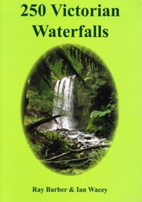 Otway Districts Historical Society
Book, Everbest Printing Company Ltd, 250 Victorian waterfalls, 2011
... There is nothing better than doing so at the base of a majestic waterfall with the spray drifing across the rock face and the unique sound of the water tumbling into the drop pool below....There is nothing better than doing so at the base of a majestic waterfall with the spray drifing across the rock face and the unique sound of the water tumbling into the drop pool below. waterfalls; ray barber; ian wacey; victoria; 250 Victorian waterfalls. ...Victoria is not noted for its waterfalls but in fact there are many hundreds of beautiful waterfalls scattered throughout the state. Each waterfall is different from the next, some remarkably so. Consider the amazing Hopetoun Falls surrounded by lush rainforest ferns near Beech Forest, compared to the often snow-covered Piemans Falls crashing down to the bottom of Bryce Gorge. This publication documents many of the more accessible waterfalls of Victoria, some for the first time, and many close to Melbourne. Ideal for bushwalkers, photographers, campers, or those who are interested in a healthy walk or looking for somewhere to enjoy a pinic lunch. There is nothing better than doing so at the base of a majestic waterfall with the spray drifing across the rock face and the unique sound of the water tumbling into the drop pool below.250 Victorian waterfalls. Ray Barber. Ian Wacey. 1st ed. Ian Wacey; Eltham North (Vic); 2011. 320 p.; illus., map, references, index. Soft cover. ISBN 978 0 646 54331 4waterfalls; ray barber; ian wacey;, victoria; -
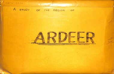 Sunshine and District Historical Society Incorporated
Archive - A Study Of The Region Of Ardeer, Sister Chanel (Sister Julia Williams), 1985
... There's Northing To Study 5384.02 - A Regional Study Of The Region Of Ardeer Page 8.jpg 1978 Municipal Directory 5384.02 - A Regional Study Of The Region Of Ardeer Page 9.jpg Text - Who Fosters It Image - House 5384.02 - A Regional Study Of The Region Of Ardeer Page 10.jpg Image - Market Gardens Yallourn Street Image - Yallourn Street 5384.02 - A Regional Study Of The Region Of Ardeer Page 11.jpg Image - Mother Of God Catholic Church Blanche Street Image - Mother Of God Catholic Church Blanche Street 5384.02 - A Regional Study Of The Region Of Ardeer Page 12.jpg Image - Scotch Thistles Image - Kororoit Creek Bridge West Street To Esmond Street 5384.02 - A Regional Study Of The Region Of Ardeer Page 13.jpg Image - Kororoit Creek Bridge Yalloun Street to Ballarat Road Image - Mother Of God Catholic Church Blanche Street 5384.02 - A Regional Study Of The Region Of Ardeer Page 14.jpg Text - Councillors, Politicians, People 5384.02 - A Regional Study Of The Region Of Ardeer Page 15.jpg Reality 5384.02 - A Regional Study Of The Region Of Ardeer Page 16.jpg Text - Geography Of The City Of Sunshine 5384.02 - A Regional Study Of The Region Of Ardeer Page 18.jpg Melway Map 5384.02 - A Regional Study Of The Region Of Ardeer Page 20.jpg Image - Kororoit Creek From Ballarat Road 5384.02 - A Regional Study Of The Region Of Ardeer Page 22.jpg Text - Basalt Sample Of A Basalt Rock When Laying Foundations For The Polish Community Hall In Helene Street 5384.02 - A Regional Study Of The Region Of Ardeer Page 23.jpg Image - Corner Yallourn Street And Rockbank Road Image - Tower Road Proposed Freeway Site (Now Scrapped) 5384.02 - A Regional Study Of The Region Of Ardeer Page 24.jpg Image - Kororoit Creek Bridge West Street To Esmond Street 5384.02 - A Regional Study Of The Region Of Ardeer Page 25.jpg Kororoit Creek Bridge West Street To Esmond Street 5384.02 - A Regional Study Of The Region Of Ardeer Page 26.jpg Image - Sunshine Swimming Pool Kororoit Creek 5384.02 - A Regional Study Of The Region Of Ardeer Page 27.jpg Text - Industry 5384.02 - A Regional Study Of The Region Of Ardeer Page 28.jpg Text - ICI 5384.02 - A Regional Study Of The Region Of Ardeer Page 29.jpg Text - ICINZ 5384.02 - A Regional Study Of The Region Of Ardeer Page 30.jpg Image - ICIANZ Ballarat Road Entrance 1979 Image - ICIANZ Explosive Reserve View From More Park Esmond Road 5384.02 - A Regional Study Of The Region Of Ardeer Page 31.jpg Image - Forrest Street Corner Fitzgerald Road Image - Entrance To ICIANZ Forrest Street 5384.02 - A Regional Study Of The Region Of Ardeer Page 32.jpg Image - Explosive Train Shunting Across Forrest Street 5384.02 - A Regional Study Of The Region Of Ardeer Page 33.jpg Image - Besco Batteries Forrest Street 5384.02 - A Regional Study Of The Region Of Ardeer Page 34.jpg Image - Queen Of Heaven Catholic Church Holt Street 5384.02 - A Regional Study Of The Region Of Ardeer Page 35.jpg Image - Ukrainian Catholic Church Forrest Street 5384.02 - A Regional Study Of The Region Of Ardeer Page 36.jpg Image - Mother Of God Catholic Church Blanche Street 5384.02 - A Regional Study Of The Region Of Ardeer Page 37.jpg Image - Ukrainian Hall Suspension Street Image - Polish Hall Helene Street 5384.02 - A Regional Study Of The Region Of Ardeer Page 38.jpg Image - Mother Of God Catholic Primary School Blanche Street 5384.02 - A Regional Study Of The Region Of Ardeer Page 39.jpg Image - Ardeer State School Looking From Suspension Street 5384.02 - A Regional Study Of The Region Of Ardeer Page 40.jpg Image - Polish Soccer Club Playgroup 5384.02 - A Regional Study Of The Region Of Ardeer Page 41.jpg Image - Holt Street Shopping Centre Image - Holt Street Milk Bar And Post Office 5384.02 - A Regional Study Of The Region Of Ardeer Page 42.jpg Image - 29 - 31 Maxwell Street Shopping Centre Image - 60 - 62 Maxwell Street Shopping Centre 5384.02 - A Regional Study Of The Region Of Ardeer Page 43.jpg Image - Motor Rail Train At Ardeer Station 5384.02 - A Regional Study Of The Region Of Ardeer Page 44.jpg Image - Ardeer Railway Station 5384.02 - A Regional Study Of The Region Of Ardeer Page 45.jpg Image - Railway Line Pedestrian Crossing Ardeer Station Ridgeway Parade To Forrest Street Image - Railway Line Pedestrian Crossing Ridgeway Parade To West Street 5384.02 - A Regional Study Of The Region Of Ardeer Page 46.jpg Image - Half House Image - Half House 5384.02 - A Regional Study Of The Region Of Ardeer Page 47.jpg Image - Small House Image - Vacant Block 5384.02 - A Regional Study Of The Region Of Ardeer Page 48.jpg Image - House Image - New House 5384.02 - A Regional Study Of The Region Of Ardeer Page 49.jpg Image - House 5384.02 - A Regional Study Of The Region Of Ardeer Page 50.jpg Image - Horse Riding School Forrest Street Image - Horse Riding School Forrest Street 5384.02 - A Regional Study Of The Region Of Ardeer Page 51.jpg Image - Kororoit Creek Image - Playground 5384.02 - A Regional Study Of The Region Of Ardeer Page 52.jpg Image - More Park Women's Sport Centre Esmond Street Image - Old Service Station Old Service Station 5384.02 - A Regional Study Of The Region Of Ardeer Page 53.jpg Image - Vegetable Garden Image - Vegetable Garden 5384.02 - A Regional Study Of The Region Of Ardeer Page 54.jpg Text - Open Space Analysis 5384.02 - A Regional Study Of The Region Of Ardeer Page 55.jpg 1976 Census 5384.02 - A Regional Study Of The Region Of Ardeer Page 56.jpg 1976 Census 5384.02 - A Regional Study Of The Region Of Ardeer Page 57.jpg 1979 Statistics 5384.02 - A Regional Study Of The Region Of Ardeer Page 58.jpg Text - Some Significant Realities 5384.02 - A Regional Study Of The Region Of Ardeer Page 59.jpg Text - A Typical Story From An Ardeerite 5384.02 - A Regional Study Of The Region Of Ardeer Page 60.jpg Text - Bibliography 5384.03 - A Regional Study Of The Region Of Ardeer - Donation Letter.jpg 5384.04 - A Regional Study Of The Region Of Ardeer - Sister Chanel Details.jpg ...There's Northing To Study 5384.02 - A Regional Study Of The Region Of Ardeer Page 8.jpg 1978 Municipal Directory 5384.02 - A Regional Study Of The Region Of Ardeer Page 9.jpg Text - Who Fosters It Image - House 5384.02 - A Regional Study Of The Region Of Ardeer Page 10.jpg Image - Market Gardens Yallourn Street Image - Yallourn Street 5384.02 - A Regional Study Of The Region Of Ardeer Page 11.jpg Image - Mother Of God Catholic Church Blanche Street Image - Mother Of God Catholic Church Blanche Street 5384.02 - A Regional Study Of The Region Of Ardeer Page 12.jpg Image - Scotch Thistles Image - Kororoit Creek Bridge West Street To Esmond Street 5384.02 - A Regional Study Of The Region Of Ardeer Page 13.jpg Image - Kororoit Creek Bridge Yalloun Street to Ballarat Road Image - Mother Of God Catholic Church Blanche Street 5384.02 - A Regional Study Of The Region Of Ardeer Page 14.jpg Text - Councillors, Politicians, People 5384.02 - A Regional Study Of The Region Of Ardeer Page 15.jpg Reality 5384.02 - A Regional Study Of The Region Of Ardeer Page 16.jpg Text - Geography Of The City Of Sunshine 5384.02 - A Regional Study Of The Region Of Ardeer Page 18.jpg Melway Map 5384.02 - A Regional Study Of The Region Of Ardeer Page 20.jpg Image - Kororoit Creek From Ballarat Road 5384.02 - A Regional Study Of The Region Of Ardeer Page 22.jpg Text - Basalt Sample Of A Basalt Rock When Laying Foundations For The Polish Community Hall In Helene Street 5384.02 - A Regional Study Of The Region Of Ardeer Page 23.jpg Image - Corner Yallourn Street And Rockbank Road Image - Tower Road Proposed Freeway Site (Now Scrapped) 5384.02 - A Regional Study Of The Region Of Ardeer Page 24.jpg Image - Kororoit Creek Bridge West Street To Esmond Street 5384.02 - A Regional Study Of The Region Of Ardeer Page 25.jpg Kororoit Creek Bridge West Street To Esmond Street 5384.02 - A Regional Study Of The Region Of Ardeer Page 26.jpg Image - Sunshine Swimming Pool Kororoit Creek 5384.02 - A Regional Study Of The Region Of Ardeer Page 27.jpg Text - Industry 5384.02 - A Regional Study Of The Region Of Ardeer Page 28.jpg Text - ICI 5384.02 - A Regional Study Of The Region Of Ardeer Page 29.jpg Text - ICINZ 5384.02 - A Regional Study Of The Region Of Ardeer Page 30.jpg Image - ICIANZ Ballarat Road Entrance 1979 Image - ICIANZ Explosive Reserve View From More Park Esmond Road 5384.02 - A Regional Study Of The Region Of Ardeer Page 31.jpg Image - Forrest Street Corner Fitzgerald Road Image - Entrance To ICIANZ Forrest Street 5384.02 - A Regional Study Of The Region Of Ardeer Page 32.jpg Image - Explosive Train Shunting Across Forrest Street 5384.02 - A Regional Study Of The Region Of Ardeer Page 33.jpg Image - Besco Batteries Forrest Street 5384.02 - A Regional Study Of The Region Of Ardeer Page 34.jpg Image - Queen Of Heaven Catholic Church Holt Street 5384.02 - A Regional Study Of The Region Of Ardeer Page 35.jpg Image - Ukrainian Catholic Church Forrest Street 5384.02 - A Regional Study Of The Region Of Ardeer Page 36.jpg Image - Mother Of God Catholic Church Blanche Street 5384.02 - A Regional Study Of The Region Of Ardeer Page 37.jpg Image - Ukrainian Hall Suspension Street Image - Polish Hall Helene Street 5384.02 - A Regional Study Of The Region Of Ardeer Page 38.jpg Image - Mother Of God Catholic Primary School Blanche Street 5384.02 - A Regional Study Of The Region Of Ardeer Page 39.jpg Image - Ardeer State School Looking From Suspension Street 5384.02 - A Regional Study Of The Region Of Ardeer Page 40.jpg Image - Polish Soccer Club Playgroup 5384.02 - A Regional Study Of The Region Of Ardeer Page 41.jpg Image - Holt Street Shopping Centre Image - Holt Street Milk Bar And Post Office 5384.02 - A Regional Study Of The Region Of Ardeer Page 42.jpg Image - 29 - 31 Maxwell Street Shopping Centre Image - 60 - 62 Maxwell Street Shopping Centre 5384.02 - A Regional Study Of The Region Of Ardeer Page 43.jpg Image - Motor Rail Train At Ardeer Station 5384.02 - A Regional Study Of The Region Of Ardeer Page 44.jpg Image - Ardeer Railway Station 5384.02 - A Regional Study Of The Region Of Ardeer Page 45.jpg Image - Railway Line Pedestrian Crossing Ardeer Station Ridgeway Parade To Forrest Street Image - Railway Line Pedestrian Crossing Ridgeway Parade To West Street 5384.02 - A Regional Study Of The Region Of Ardeer Page 46.jpg Image - Half House Image - Half House 5384.02 - A Regional Study Of The Region Of Ardeer Page 47.jpg Image - Small House Image - Vacant Block 5384.02 - A Regional Study Of The Region Of Ardeer Page 48.jpg Image - House Image - New House 5384.02 - A Regional Study Of The Region Of Ardeer Page 49.jpg Image - House 5384.02 - A Regional Study Of The Region Of Ardeer Page 50.jpg Image - Horse Riding School Forrest Street Image - Horse Riding School Forrest Street 5384.02 - A Regional Study Of The Region Of Ardeer Page 51.jpg Image - Kororoit Creek Image - Playground 5384.02 - A Regional Study Of The Region Of Ardeer Page 52.jpg Image - More Park Women's Sport Centre Esmond Street Image - Old Service Station Old Service Station 5384.02 - A Regional Study Of The Region Of Ardeer Page 53.jpg Image - Vegetable Garden Image - Vegetable Garden 5384.02 - A Regional Study Of The Region Of Ardeer Page 54.jpg Text - Open Space Analysis 5384.02 - A Regional Study Of The Region Of Ardeer Page 55.jpg 1976 Census 5384.02 - A Regional Study Of The Region Of Ardeer Page 56.jpg 1976 Census 5384.02 - A Regional Study Of The Region Of Ardeer Page 57.jpg 1979 Statistics 5384.02 - A Regional Study Of The Region Of Ardeer Page 58.jpg Text - Some Significant Realities 5384.02 - A Regional Study Of The Region Of Ardeer Page 59.jpg Text - A Typical Story From An Ardeerite 5384.02 - A Regional Study Of The Region Of Ardeer Page 60.jpg Text - Bibliography 5384.03 - A Regional Study Of The Region Of Ardeer - Donation Letter.jpg 5384.04 - A Regional Study Of The Region Of Ardeer - Sister Chanel Details.jpg A large envelope containing over 50 black & white photographs, statistics charts, several maps mounted on coloured card with text. ...Sister Chanel, was later known as Sister Julia Williams. She was professed on the 7th December 1963. She is mentioned in a history of the Brigidine Sister, by Morna Sturrock, Women of Strength, Women of Gentleness: Brigidine Sisters - Victoria Province, David Lovell Publishing, Victoria Australia, 1995, page 290. Sister Chanel (Sister Julia Williams) undertook a study of Ardeer in 1985, as part of her university studies. At the time, she was based at the Brigidine Convent in Blanche Street, Ardeer, opposite the Mother of God Catholic Primary School. Some years later, she was living at Unit 3, 387 Station Street, Bonbeach, Vic, 3196. Today, the Brigidine Convent at Ardeer no longer exists. The buildings have been demolished. The local schools begun by the Brigidine Sisters are now entirely staffed by lay teachers. There is a Brigidine Centre in Malvern, which contains archives relating to the Brigidine Sisters' history.The Brigidine Sisters (often misheard as “Bridiline”) are a long‑established Catholic religious congregation with a major historical presence in Melbourne, especially in education and social justice work. They arrived in Victoria in the 1880s and continue to operate schools, ministries, and community programs across the state.5384.01 - A Regional Study Of The Region Of Ardeer Envelope.jpg Text - A Regional Study Of The Region Of Ardeer 5384.02 - A Regional Study Of The Region Of Ardeer Page 1.jpg Text - A Regional Study Of The Region Of Ardeer 5384.02 - A Regional Study Of The Region Of Ardeer Page 2.jpg 5384.02 - A Regional Study Of The Region Of Ardeer Page 3.jpg Text - Subject HU211 Regionalism And Australia 5384.02 - A Regional Study Of The Region Of Ardeer Page 4.jpg Text - Ardeer Regions Selected 5384.02 - A Regional Study Of The Region Of Ardeer Page 5.jpg Melway Map 5384.02 - A Regional Study Of The Region Of Ardeer Page 6.jpg Text - Ardeer Never Heard Of It. Wheres That? 5384.02 - A Regional Study Of The Region Of Ardeer Page 7.jpg Text - Study The Region of Ardeer. There's Northing To Study 5384.02 - A Regional Study Of The Region Of Ardeer Page 8.jpg 1978 Municipal Directory 5384.02 - A Regional Study Of The Region Of Ardeer Page 9.jpg Text - Who Fosters It Image - House 5384.02 - A Regional Study Of The Region Of Ardeer Page 10.jpg Image - Market Gardens Yallourn Street Image - Yallourn Street 5384.02 - A Regional Study Of The Region Of Ardeer Page 11.jpg Image - Mother Of God Catholic Church Blanche Street Image - Mother Of God Catholic Church Blanche Street 5384.02 - A Regional Study Of The Region Of Ardeer Page 12.jpg Image - Scotch Thistles Image - Kororoit Creek Bridge West Street To Esmond Street 5384.02 - A Regional Study Of The Region Of Ardeer Page 13.jpg Image - Kororoit Creek Bridge Yalloun Street to Ballarat Road Image - Mother Of God Catholic Church Blanche Street 5384.02 - A Regional Study Of The Region Of Ardeer Page 14.jpg Text - Councillors, Politicians, People 5384.02 - A Regional Study Of The Region Of Ardeer Page 15.jpg Reality 5384.02 - A Regional Study Of The Region Of Ardeer Page 16.jpg Text - Geography Of The City Of Sunshine 5384.02 - A Regional Study Of The Region Of Ardeer Page 18.jpg Melway Map 5384.02 - A Regional Study Of The Region Of Ardeer Page 20.jpg Image - Kororoit Creek From Ballarat Road 5384.02 - A Regional Study Of The Region Of Ardeer Page 22.jpg Text - Basalt Sample Of A Basalt Rock When Laying Foundations For The Polish Community Hall In Helene Street 5384.02 - A Regional Study Of The Region Of Ardeer Page 23.jpg Image - Corner Yallourn Street And Rockbank Road Image - Tower Road Proposed Freeway Site (Now Scrapped) 5384.02 - A Regional Study Of The Region Of Ardeer Page 24.jpg Image - Kororoit Creek Bridge West Street To Esmond Street 5384.02 - A Regional Study Of The Region Of Ardeer Page 25.jpg Kororoit Creek Bridge West Street To Esmond Street 5384.02 - A Regional Study Of The Region Of Ardeer Page 26.jpg Image - Sunshine Swimming Pool Kororoit Creek 5384.02 - A Regional Study Of The Region Of Ardeer Page 27.jpg Text - Industry 5384.02 - A Regional Study Of The Region Of Ardeer Page 28.jpg Text - ICI 5384.02 - A Regional Study Of The Region Of Ardeer Page 29.jpg Text - ICINZ 5384.02 - A Regional Study Of The Region Of Ardeer Page 30.jpg Image - ICIANZ Ballarat Road Entrance 1979 Image - ICIANZ Explosive Reserve View From More Park Esmond Road 5384.02 - A Regional Study Of The Region Of Ardeer Page 31.jpg Image - Forrest Street Corner Fitzgerald Road Image - Entrance To ICIANZ Forrest Street 5384.02 - A Regional Study Of The Region Of Ardeer Page 32.jpg Image - Explosive Train Shunting Across Forrest Street 5384.02 - A Regional Study Of The Region Of Ardeer Page 33.jpg Image - Besco Batteries Forrest Street 5384.02 - A Regional Study Of The Region Of Ardeer Page 34.jpg Image - Queen Of Heaven Catholic Church Holt Street 5384.02 - A Regional Study Of The Region Of Ardeer Page 35.jpg Image - Ukrainian Catholic Church Forrest Street 5384.02 - A Regional Study Of The Region Of Ardeer Page 36.jpg Image - Mother Of God Catholic Church Blanche Street 5384.02 - A Regional Study Of The Region Of Ardeer Page 37.jpg Image - Ukrainian Hall Suspension Street Image - Polish Hall Helene Street 5384.02 - A Regional Study Of The Region Of Ardeer Page 38.jpg Image - Mother Of God Catholic Primary School Blanche Street 5384.02 - A Regional Study Of The Region Of Ardeer Page 39.jpg Image - Ardeer State School Looking From Suspension Street 5384.02 - A Regional Study Of The Region Of Ardeer Page 40.jpg Image - Polish Soccer Club Playgroup 5384.02 - A Regional Study Of The Region Of Ardeer Page 41.jpg Image - Holt Street Shopping Centre Image - Holt Street Milk Bar And Post Office 5384.02 - A Regional Study Of The Region Of Ardeer Page 42.jpg Image - 29 - 31 Maxwell Street Shopping Centre Image - 60 - 62 Maxwell Street Shopping Centre 5384.02 - A Regional Study Of The Region Of Ardeer Page 43.jpg Image - Motor Rail Train At Ardeer Station 5384.02 - A Regional Study Of The Region Of Ardeer Page 44.jpg Image - Ardeer Railway Station 5384.02 - A Regional Study Of The Region Of Ardeer Page 45.jpg Image - Railway Line Pedestrian Crossing Ardeer Station Ridgeway Parade To Forrest Street Image - Railway Line Pedestrian Crossing Ridgeway Parade To West Street 5384.02 - A Regional Study Of The Region Of Ardeer Page 46.jpg Image - Half House Image - Half House 5384.02 - A Regional Study Of The Region Of Ardeer Page 47.jpg Image - Small House Image - Vacant Block 5384.02 - A Regional Study Of The Region Of Ardeer Page 48.jpg Image - House Image - New House 5384.02 - A Regional Study Of The Region Of Ardeer Page 49.jpg Image - House 5384.02 - A Regional Study Of The Region Of Ardeer Page 50.jpg Image - Horse Riding School Forrest Street Image - Horse Riding School Forrest Street 5384.02 - A Regional Study Of The Region Of Ardeer Page 51.jpg Image - Kororoit Creek Image - Playground 5384.02 - A Regional Study Of The Region Of Ardeer Page 52.jpg Image - More Park Women's Sport Centre Esmond Street Image - Old Service Station Old Service Station 5384.02 - A Regional Study Of The Region Of Ardeer Page 53.jpg Image - Vegetable Garden Image - Vegetable Garden 5384.02 - A Regional Study Of The Region Of Ardeer Page 54.jpg Text - Open Space Analysis 5384.02 - A Regional Study Of The Region Of Ardeer Page 55.jpg 1976 Census 5384.02 - A Regional Study Of The Region Of Ardeer Page 56.jpg 1976 Census 5384.02 - A Regional Study Of The Region Of Ardeer Page 57.jpg 1979 Statistics 5384.02 - A Regional Study Of The Region Of Ardeer Page 58.jpg Text - Some Significant Realities 5384.02 - A Regional Study Of The Region Of Ardeer Page 59.jpg Text - A Typical Story From An Ardeerite 5384.02 - A Regional Study Of The Region Of Ardeer Page 60.jpg Text - Bibliography 5384.03 - A Regional Study Of The Region Of Ardeer - Donation Letter.jpg 5384.04 - A Regional Study Of The Region Of Ardeer - Sister Chanel Details.jpg -
 Marysville & District Historical Society
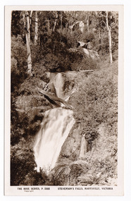
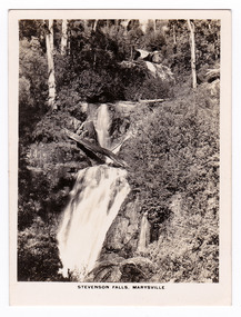
Postcard (item) - Black and white postcard, Rose Stereograph Company, Stevenson's Falls, Marysville, Victoria, 1913-1967
... The falls are split into roughly five cascades, with the last of these plunging into a small, picturesque rock pool. This postcard was produced by the Rose Stereograph Company as a souvenir of Marysville. stevenson's falls marysville victoria waterfall p. 2302 rose series postcard postcard souvenir john steavenson steavenson falls REAL PHOTO POST CARD THE "ROSE" SERIES DE LUXE PRODUCED IN AUSTRALIA PUBLISHED BY "THE ROSE STEREOGRAPH" Armadale,/ Victoria. ...A postcard in a series produced by the Rose Stereograph Company in Victoria, Australia as a souvenir of Marysville.A black and white photograph of Steavenson Falls, Marysville, Victoria. The Steavenson Falls is named after the Victorian Assistant Commissioner of Roads and Bridges, John Steavenson, who arrived in Victoria in the early 1860s. At 84 metres high, Steavenson Falls is Victoria's tallest cascading waterfall. The falls are split into roughly five cascades, with the last of these plunging into a small, picturesque rock pool. This postcard was produced by the Rose Stereograph Company as a souvenir of Marysville.REAL PHOTO POST CARD THE "ROSE" SERIES DE LUXE PRODUCED IN AUSTRALIA PUBLISHED BY "THE ROSE STEREOGRAPH" Armadale,/ Victoria.stevenson's falls, marysville, victoria, waterfall, p. 2302, rose series postcard, postcard, souvenir, john steavenson, steavenson falls -
 Marysville & District Historical Society
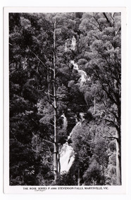
Postcard (item) - Black and white postcard, Rose Stereograph Company, Stevenson's Falls, Marysville, Victoria, 1916
... The falls are split into roughly five cascades, with the last of these plunging into a small, picturesque rock pool. This postcard was produced by the Rose Stereograph Company as a souvenir of Marysville. stevenson's falls steavensons falls marysville victoria waterfall p. 2303 rose series postcard postcard souvenir john steavenson REAL PHOTO POST CARD THE "ROSE" SERIES DE LUXE PRODUCED IN AUSTRALIA PUBLISHED BY THE ROSE STEREOGRAPHS Armadale Victoria. ...A postcard in a series produced by the Rose Stereograph Company as a souvenir of Marysville. A black and white photograph of Steavenson Falls, Marysville, Victoria. The Steavenson Falls is named after the Victorian Assistant Commissioner of Roads and Bridges, John Steavenson, who arrived in Victoria in the early 1860s. At 84 metres high, Steavenson Falls is Victoria's tallest cascading waterfall. The falls are split into roughly five cascades, with the last of these plunging into a small, picturesque rock pool. This postcard was produced by the Rose Stereograph Company as a souvenir of Marysville.REAL PHOTO POST CARD THE "ROSE" SERIES DE LUXE PRODUCED IN AUSTRALIA PUBLISHED BY THE ROSE STEREOGRAPHS Armadale Victoria.stevenson's falls, steavensons falls, marysville, victoria, waterfall, p. 2303, rose series postcard, postcard, souvenir, john steavenson -
 Marysville & District Historical Society
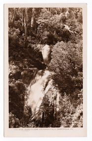
Postcard (item) - Black and white postcard, Rose Stereograph Company, Stevenson Falls, Marysville, Vic, 1913-1967
... The falls are split into roughly five cascades, with the last of these plunging into a small, picturesque rock pool. This postcard was produced by the Rose Stereograph Company as a souvenir of Marysville. marysville victoria waterfalls p. 4990 stevenson falls steavenson falls rose series postcard postcard souvenir john steavenson POST CARD The "Rose" Series/ De Luxe A Real Photograph/ Produced in Australia Published by the Rose Stereograph Co,/ Armadale, Victoria. ...A postcard in a series produced by the Rose Stereograph Company in Victoria, Australia as a souvenir of Marysville.A black and white photograph of Steavenson Falls in Marysville in Victoria. The Steavenson Falls is named after the Victorian Assistant Commissioner of Roads and Bridges, John Steavenson, who arrived in Victoria in the early 1860s. At 84 metres high, Steavenson Falls is Victoria's tallest cascading waterfall. The falls are split into roughly five cascades, with the last of these plunging into a small, picturesque rock pool. This postcard was produced by the Rose Stereograph Company as a souvenir of Marysville.POST CARD The "Rose" Series/ De Luxe A Real Photograph/ Produced in Australia Published by the Rose Stereograph Co,/ Armadale, Victoria.marysville, victoria, waterfalls, p. 4990, stevenson falls, steavenson falls, rose series postcard, postcard, souvenir, john steavenson -
 Marysville & District Historical Society
Postcard (item) - Black and white postcard, Rose Stereograph Company, Stevenson Falls, Marysville, Vic, 1913-1967
... The falls are split into roughly five cascades, with the last of these plunging into a small, picturesque rock pool. This postcard was produced by the Rose Stereograph Company as a souvenir of Marysville. stevenson falls marysville victoria waterfalls p. 10200 steavenson falls rose series postcard postcard souvenir john steavenson THE ROSE SERIES P. 10200/ COPYRIGHT/ STEVENSON FALLS, MARYSVILLE, VIC. ...A postcard in a series produced by the Rose Stereograph Company in Victoria, Australia as a souvenir of Marysville. The Steavenson Falls is named after the Victorian Assistant Commissioner of Roads and Bridges, John Steavenson, who arrived in Victoria in the early 1860s.A black and white photograph of Steavenson Falls, Marysville, Victoria. The Steavenson Falls is named after the Victorian Assistant Commissioner of Roads and Bridges, John Steavenson, who arrived in Victoria in the early 1860s. At 84 metres high, Steavenson Falls is Victoria's tallest cascading waterfall. The falls are split into roughly five cascades, with the last of these plunging into a small, picturesque rock pool. This postcard was produced by the Rose Stereograph Company as a souvenir of Marysville.THE ROSE SERIES P. 10200/ COPYRIGHT/ STEVENSON FALLS, MARYSVILLE, VIC. POST CARD The "Rose" Series/ De Luxe A Real Photograph/ Produced in Australia Published by the Rose Stereograph Co.,/ Sydney and Melbournestevenson falls, marysville, victoria, waterfalls, p. 10200, steavenson falls, rose series postcard, postcard, souvenir, john steavenson -
 Marysville & District Historical Society
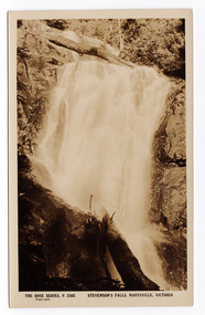
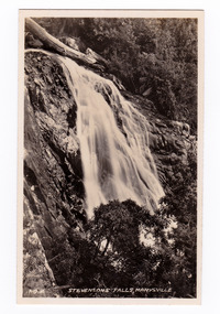
Photograph (item) - Black and white photograph, Rose Stereograph Company, Stevenson Falls, Marysville, 1913-1967
... The falls are split into roughly five cascades, with the last of these plunging into a small, picturesque rock pool. The photograph was published by the Rose Stereograph Company and was used to produce the Rose Series postcard P.2302. stevenson falls steavenson falls marysville victoria p. 2302 photograph rose series postcard souvenir rose stereograph company john steavenson An early black and white photograph of Steavenson Falls in Marysville, Victoria. ...A black and white photograph of Steavenson Falls, Marysville in Victoria.A black and white photograph of Steavenson Falls, Marysville in Victoria. The Steavenson Falls is named after the Victorian Assistant Commissioner of Roads and Bridges, John Steavenson who arrived in Victoria in the early 1860s. At 84 metres high, Steavenson Falls is Victoria's tallest cascading waterfall. The falls are split into roughly five cascades, with the last of these plunging into a small, picturesque rock pool. The photograph was published by the Rose Stereograph Company and was used to produce the Rose Series postcard P.2302.stevenson falls, steavenson falls, marysville, victoria, p. 2302, photograph, rose series postcard, souvenir, rose stereograph company, john steavenson -
 Marysville & District Historical Society
Photograph (item) - Black and white photograph, Valentine Publishing Co. Pty. Ltd, No.2. Stevensons Falls, Marysville, 1923-1963
... The falls are split into roughly five cascades, with the last of these plunging into a small, picturesque rock pool. This photograph was published by the Valentine Publishing Co Pty. ...A black and white photograph of Steavenson Falls, Marysville, Victoria.A black and white photograph of Steavenson Falls, Marysville, Victoria. The Steavenson Falls is named after the Victorian Assistant Commissioner of Roads and Bridges, John Steavenson who arrived in Victoria in the early 1860s. At 84 metres high, Steavenson Falls is Victoria's tallest cascading waterfall. The falls are split into roughly five cascades, with the last of these plunging into a small, picturesque rock pool. This photograph was published by the Valentine Publishing Co Pty. Ltd. as a souvenir of Marysville.stevenson falls, steavenson's falls, marysville, john steavenson, victoria, history, valentine publishing co, souvenir -
 Marysville & District Historical Society
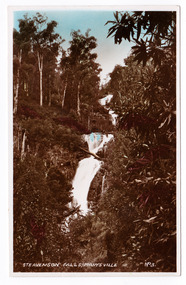
Postcard (item) - Colour tinted postcard, Valentine Publishing Co. Pty. Ltd, Steavenson Falls, Marysville No.3, 1923-1963
... The falls are split into roughly five cascades, with the last of these plunging into a small, picturesque rock pool. This postcard was published by the Valentine Publishing Co. ...An early colour tinted photograph of Steavenson Falls, Marysville, Victoria.An early colour tinted photograph of Steavenson Falls, Marysville, Victoria. The Steavenson Falls is named after the Victorian Assistant Commissioner of Roads and Bridges, John Steavenson who arrived in Victoria in the early 1860s. At 84 metres high, Steavenson Falls is Victoria's tallest cascading waterfall. The falls are split into roughly five cascades, with the last of these plunging into a small, picturesque rock pool. This postcard was published by the Valentine Publishing Co. Pty. Ltd as a souvenir of Marysville. Valentine's/ POST/ CARD SENDING YOU GREETINGS/ FOR ADDRESS ONLY PRINTED IN/ GT BRITAIN Published by The Valentine Publishing Co., Sydney and Melbourne. -THIS IS A REAL PHOTOGRAPH-steavenson falls, steavenson's falls, marysville, victoria, waterfalls, postcard, valentine publishing co, souvenir, john steavenson -
 Marysville & District Historical Society
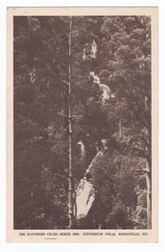
Postcard (item) - Black and white postcard, Stevenson Falls, Marysville, Vic, 1930
... The falls are split into roughly five cascades, with the last of these plunging into a small, picturesque rock pool. This postcard was produced by the Rose Stereograph Company as a souvenir of Marysville. marysville victoria waterfalls stevenson falls steavenson falls southern cross series 4990 postcard souvenir john steavenson THE SOUTHERN CROSS SERIES 4990./ COPYRIGHT/ STEVENSON FALLS, MARYSVILLE, VIC. ...A postcard in a series produced by the Rose Stereograph Company in Victoria, Australia.A black and white photograph of Steavenson Falls, Marysville, Victoria. The Steavenson Falls is named after the Victorian Assistant Commissioner of Roads and Bridges, John Steavenson, who arrived in Victoria in the early 1860s. At 84 metres high, Steavenson Falls is Victoria's tallest cascading waterfall. The falls are split into roughly five cascades, with the last of these plunging into a small, picturesque rock pool. This postcard was produced by the Rose Stereograph Company as a souvenir of Marysville.THE SOUTHERN CROSS SERIES 4990./ COPYRIGHT/ STEVENSON FALLS, MARYSVILLE, VIC. POST CARD. Correspondence/ Address Mt. Kitchener House/ Marysville Dear Dad,/ I'm having a/ great time up here,/ I don't suppose you/ remember, but we used/ to walk up to see these/ falls when you were up/ here with me. I hope you/ like being at No. 6./ However, it won't be/ much longer now - I'll/ be home on Saturday./ Love to you all,/ Marjoriemarysville, victoria, waterfalls, stevenson falls, steavenson falls, southern cross series, 4990, postcard, souvenir, john steavenson