Showing 10 items matching "rock temperature"
-
 Bendigo Historical Society Inc.
Newspaper - Kangaroo Flat Gold Mine Collection: Bendigo Goldfield
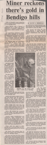
... ...rock temperature...Mine ventilation and rock temperatures in the New Argus (Eaglehawk) and the New Chum Railway at Golden Square were researched by David Pascoe. ...Mine ventilation and rock temperatures in the New Argus (Eaglehawk) and the New Chum Railway at Golden Square were researched by David Pascoe. ...'Bendigo Advertiser' article, 15th March , 1995, titled ' Miner reckons there's gold in Bendigo hills'. Comments from Mr. David Pascoe (miner and Mines Inspector) and Mr. Harry Clarke (former miner, Mines Inspector and mine manager) state that 'synclinal folds and inverted saddle reefs had been almost entirely neglected by Bendigo miners'. Mine ventilation and rock temperatures in the New Argus (Eaglehawk) and the New Chum Railway at Golden Square were researched by David Pascoe. Pascoe said 'the resources of the Bendigo field are enormous when it is considered that there are 516 kilometres of surveyed lines of reef down to the depth mines; by including the synclines it almost doubles that figure without any deeper penentration of the field'. gold mining, bendigo, bendigo mining nl, harry clarke, david pascoe, quartz legstones, saddle reef, spurs, mine ventilation, rock temperature, new argus, new chum, garden gully reef -
 Bendigo Historical Society Inc.
Document - Kangaroo Flat Gold Mine Collection: Historical and Modern Mine Ventilation, Rowland Hill, October 2001
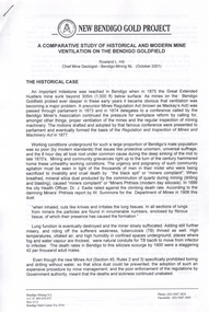
... ...rock temperature...Bendigo mining gold Kangaroo Flat New Bendigo Gold Project mine ventilation rock temperature Victorian Department of Mines phthisis tuberculosis humidity Five page document titled 'New Bendigo Gold Project, a Comparative Study of Historical and Modern Mine Ventilation on the Bendigo Goldfield, Rowland L. ...Five page document titled 'New Bendigo Gold Project, a Comparative Study of Historical and Modern Mine Ventilation on the Bendigo Goldfield, Rowland L. Hill, Chief Mine Geologist, Bendigo Mining NL, (October 2001). Study compares ventilation practices for two periods of time, citing historical examples of ventilation in Bendigo mines in the 19th and early 20th century and compares them to modern practices. bendigo mining n.l., bendigo, mining, gold, kangaroo flat, new bendigo gold project, mine ventilation, rock temperature, victorian department of mines, phthisis, tuberculosis, humidity -
 Bendigo Historical Society Inc.
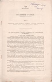
Document - MINING REPORTS -DEPARTMENT OF MINES, REPORT ON OBSERVATIONS OF UNDERGROUND TEMPERATURE AT BENDIGO
... Report mentions temperature increases as the mines get deeper, temperature of air and rocks, Meteorological Observations at 180 Mine, Bendigo, comparison temperature in other parts of the world and Bendigo, Temperature of air at the 180 Mine, Shenandoah Mine, victoria Quartz, Shamrock, Great Extended Hustlers, Princess Dagmar and United Hustlers and Redan, Daily Variation of Temperature and Pressure of the Air, Temperature of Fault Line, Drawing of Lansell's No 180 Mine showing levels, geological features, graph of Curves of Atmosphere Pressure at 180 Mine Bendigo, graph of Curves of Temperature at 180 Mine Bendigo, Lansell's 180 Mine Rate of Aincrease of Rock Temperature, Comparisons with Observations in other Countries, Observations in November and December 1895, Meteorological Observations at New Chum Railway Mine Bendigo, Kiagram of working 'ends' showing temperatures therein at the New Chum Railway Mine Bendigo Vic, Additional Observations at Lansell's 180 Mine, Shamrock, Princess Dagmar, United Hustlers and Redan and Great Extended Hustler's, Humidity with formula which was adopted, Hygrometer Observations, The Ventilating Currents (and formula), Notes on Anemometer Records 180 Mine, Tabulated List showing Velocities of Air Currents at Various Levels in the 180 Mine Bendigo, Pressure of Air (and formula), Composition of the Air at Lansell's 180 Mine, Shamrock, Princess Dagmar, Gt Extended Hustlers and United Hustlers and Redan and Miners' Complaints. ...Report mentions temperature increases as the mines get deeper, temperature of air and rocks, Meteorological Observations at 180 Mine, Bendigo, comparison temperature in other parts of the world and Bendigo, Temperature of air at the 180 Mine, Shenandoah Mine, victoria Quartz, Shamrock, Great Extended Hustlers, Princess Dagmar and United Hustlers and Redan, Daily Variation of Temperature and Pressure of the Air, Temperature of Fault Line, Drawing of Lansell's No 180 Mine showing levels, geological features, graph of Curves of Atmosphere Pressure at 180 Mine Bendigo, graph of Curves of Temperature at 180 Mine Bendigo, Lansell's 180 Mine Rate of Aincrease of Rock Temperature, Comparisons with Observations in other Countries, Observations in November and December 1895, Meteorological Observations at New Chum Railway Mine Bendigo, Kiagram of working 'ends' showing temperatures therein at the New Chum Railway Mine Bendigo Vic, Additional Observations at Lansell's 180 Mine, Shamrock, Princess Dagmar, United Hustlers and Redan and Great Extended Hustler's, Humidity with formula which was adopted, Hygrometer Observations, The Ventilating Currents (and formula), Notes on Anemometer Records 180 Mine, Tabulated List showing Velocities of Air Currents at Various Levels in the 180 Mine Bendigo, Pressure of Air (and formula), Composition of the Air at Lansell's 180 Mine, Shamrock, Princess Dagmar, Gt Extended Hustlers and United Hustlers and Redan and Miners' Complaints. ...Printed Report on Observations of Underground Temperature at Bendigo, by James Stirling, Government Geologist. Report mentions temperature increases as the mines get deeper, temperature of air and rocks, Meteorological Observations at 180 Mine, Bendigo, comparison temperature in other parts of the world and Bendigo, Temperature of air at the 180 Mine, Shenandoah Mine, victoria Quartz, Shamrock, Great Extended Hustlers, Princess Dagmar and United Hustlers and Redan, Daily Variation of Temperature and Pressure of the Air, Temperature of Fault Line, Drawing of Lansell's No 180 Mine showing levels, geological features, graph of Curves of Atmosphere Pressure at 180 Mine Bendigo, graph of Curves of Temperature at 180 Mine Bendigo, Lansell's 180 Mine Rate of Aincrease of Rock Temperature, Comparisons with Observations in other Countries, Observations in November and December 1895, Meteorological Observations at New Chum Railway Mine Bendigo, Kiagram of working 'ends' showing temperatures therein at the New Chum Railway Mine Bendigo Vic, Additional Observations at Lansell's 180 Mine, Shamrock, Princess Dagmar, United Hustlers and Redan and Great Extended Hustler's, Humidity with formula which was adopted, Hygrometer Observations, The Ventilating Currents (and formula), Notes on Anemometer Records 180 Mine, Tabulated List showing Velocities of Air Currents at Various Levels in the 180 Mine Bendigo, Pressure of Air (and formula), Composition of the Air at Lansell's 180 Mine, Shamrock, Princess Dagmar, Gt Extended Hustlers and United Hustlers and Redan and Miners' Complaints. A Richardson name written on the top right corner.A. Richardson, 29 Harrison St., Bendigogold, mining reports, mining reports, report on observations of underground temperature at bendigo, department of mines, james travis, the hon henry foster, james stirling, 180 mine, shenandoah mine, victoria quartz, shamrock, great extended hustlers, princess dagmar, united hustlers and redan, new chum railway mine, north old chum, m grehauf, dr boyd, robt s brain -
 Kiewa Valley Historical Society
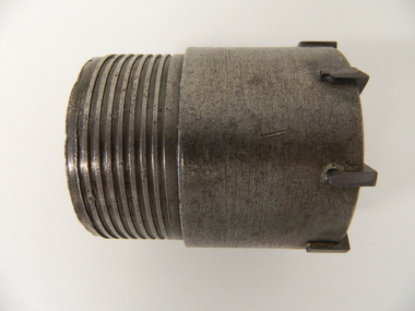
Drill Bit Diamond, circa mid to late 1900's
... rock. The use of "coring" to obtained samples for the SEC Kiewa Hydro Electricity Scheme(1920's onward) was to analyse the core to obtain temperature and rainfall patterns shown by the levels of layered solidified soil(rock). ...rock. The use of "coring" to obtained samples for the SEC Kiewa Hydro Electricity Scheme(1920's onward) was to analyse the core to obtain temperature and rainfall patterns shown by the levels of layered solidified soil(rock). ...This hollow core bit has hard cutting inserts for drilling into rock. It was used to drill and recover 50mm diameter (most common size) rock cores. The rock cores were assessed by geologists and engineers to provide information for design of structures such as tunnels, dams and underground power stations (eg. McKay Creek Power Station, West Kiewa Power Station). This type of bit was also used where damage to the surrounding rock had to be minimised. The Diamond Drill Bit,used in the early 1900's, when it was primarily used as a method of sampling rock for ore deposits and oil exploration resulting in a "coring" of rock. The use of "coring" to obtained samples for the SEC Kiewa Hydro Electricity Scheme(1920's onward) was to analyse the core to obtain temperature and rainfall patterns shown by the levels of layered solidified soil(rock). This diamond drill would have been used in the early 1900's to provide a sub strata map of temperature and water patterns (over an long period of time). This was a pre requisite to any decisions about the viability of the region to provide the water needed for a successful hydro electricity scheme.This diamond drill for core sampling was at the forefront of the analysis whether to construct a hydro electrical facility in the Kiewa Valley and the adjoining alpine region. The rock core samples produced were assessed by geologists and structural engineers. It was only after extensive core drilling covering the region that solid scientific evidence could be provided to start the "SEC Vic Hydro Electricity Scheme" within its current boundaries.This "diamond" drill bit has eight "teeth" at its cutting edge. The drill creates an 55mm hole in extremely hard rock material to obtain 50mm core samples.. Three quarters down the shank it has thread screw channels to attach the bit to the drill pipe. The coring pipe attaches via screwing it onto this bit. Core samples are the main objective of this tool.alternate energy supplies, alpine feasibility studies temperature, rainfall, sec, kiewa hydro electric scheme, electricity -
 Kiewa Valley Historical Society
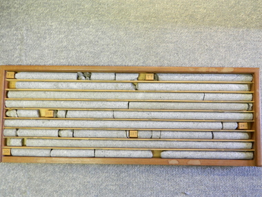
Core Rock Samples
... These rock core samples are very significant in the formulation and placement of the underground Power Stations and their maze of tunnels (in and out) for a successful implementation of the Hydro Scheme. The amount of pre-planning and engineering studies required for such a large scheme must be undertaken to ensure that a "white elephant" was not the result. alternate energy supplies alpine feasibility studies temperature rainfall sec kiewa hydro scheme electricity Depth levels (retrieved from) are shown for each section on wooden Blocks: 1st Block: "7'10" (seven feet, ten inches), 2nd Block:"9'4" (nine feet, four inches), 3rd Block: "19'3" (nineteen feet, three inches), 4th Block: "24'2" (twenty four feet, two inches), 5th Block: "25'7"( twenty five feet, seven inches) and last block: "30' (thirty feet)" There are nine columns of rock cores, each 30mm in diameter, set in a wooden display rack. ...The core samples in the display cabinet were obtained from the various sites at which drilling into the rock surface was carried out (under the control of design and structural engineers of the SEC Kiewa Hydro Scheme - late 1940's). This function was a precursor to the decision where to locate, in this case, the McKay Creek Power Station. The information gained by structural engineers from the core samples would be used also for the placements of underground tunnels entry and exit points and the overall effective size of the generator plant. This would have included drill and blast techniques (rock characteristics play an import part of explosion control), requirements for support structures and reinforcing cement/steel forms. The use and replenishment of diamond drill bits(the strongest available, see KVHS 0280) was dependent on the "type" of rock found (harder rock required greater numbers of drill bits). Support beams for reinforced ceilings and floors was also a necessity.These rock core samples are very significant in the formulation and placement of the underground Power Stations and their maze of tunnels (in and out) for a successful implementation of the Hydro Scheme. The amount of pre-planning and engineering studies required for such a large scheme must be undertaken to ensure that a "white elephant" was not the result.There are nine columns of rock cores, each 30mm in diameter, set in a wooden display rack. A clear plastic (slide out) protective panel is installed to the front section. Within each column are block details of the depth from which that section was brought from. See KVHS for the appropriate sketch details.Depth levels (retrieved from) are shown for each section on wooden Blocks: 1st Block: "7'10" (seven feet, ten inches), 2nd Block:"9'4" (nine feet, four inches), 3rd Block: "19'3" (nineteen feet, three inches), 4th Block: "24'2" (twenty four feet, two inches), 5th Block: "25'7"( twenty five feet, seven inches) and last block: "30' (thirty feet)"alternate energy supplies, alpine feasibility studies temperature, rainfall, sec, kiewa hydro scheme, electricity -
 Kiewa Valley Historical Society
Sketch Rock Core Display, circa mid to late 1900's
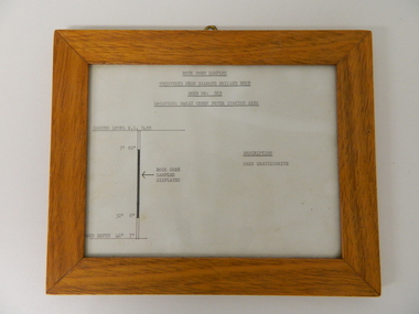
... The visual derails of where the rock core samples were removed is very significant in the formulation and placement of the underground Power Stations and their maze of tunnels(in and out) for a successful implementation of the Hydro Scheme. The amount of pre-planning and scientific studies required for such a large scheme must be undertaken to ensure that a "white elephant" was not the result. alternate energy supplies alpine feasibility studies temperature rainfall sec kiewa hydro scheme electricity The sign heading "ROCK CORE SAMPLES RECOVERED FROM DIAMOND DRILLED BORE" underneath this "BORE NO: 883" and below this "LOCATION: McKAY CREEK POWER STATION AREA" to the left a sketch incorporating the ground level point "GROUND LEVEL R.L.3493", and the core depth point "CORE DEPTH 40' 7". ...This framed sketch details, in graphic form, where the core samples in the display cabinet were removed. The drilling was a precursor to the decision where to locate, in this case, the McKay Creek Power Station. The information gained by structural engineers from the core samples would be used also for the placements of underground tunnels entry and exit points and the overall effective size of the plant. This would have included drill and blast techniques(rock characteristics play an import part of explosion control), requirements for support structures and reinforcing cement/steel forms. The use and replenishment of diamond drill bits(the strongest available, see KVHS 0280) was dependent on the "type" of rock found. Support beams for reinforced ceilings and floors was also a necessity.The visual derails of where the rock core samples were removed is very significant in the formulation and placement of the underground Power Stations and their maze of tunnels(in and out) for a successful implementation of the Hydro Scheme. The amount of pre-planning and scientific studies required for such a large scheme must be undertaken to ensure that a "white elephant" was not the result.This framed and glass front rock core display sketch has type written information of the rock samples displayed in KVHS 0279 (A). It has a softwood stained and glossed frame with a fixed(nailed) back board and a brass fixture for mounting onto a wall.The paper and type are slighted faded (sunlight affected). The sign heading "ROCK CORE SAMPLES RECOVERED FROM DIAMOND DRILLED BORE" underneath this "BORE NO: 883" and below this "LOCATION: McKAY CREEK POWER STATION AREA" to the left a sketch incorporating the ground level point "GROUND LEVEL R.L.3493", and the core depth point "CORE DEPTH 40' 7". In between and representing( in visual form) the core location areain question.alternate energy supplies, alpine feasibility studies temperature, rainfall, sec, kiewa hydro scheme, electricity -
 The Beechworth Burke Museum
Geological specimen - Slate (Metamorphic), Unknown
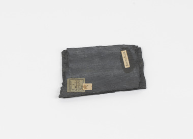
... Slate is a fine-grained, low-grade metamorphic rock that is formed by the transformation of mudstone, shale or sometimes volcanic ash under low pressure and temperatures. ...Slate is a fine-grained, low-grade metamorphic rock that is formed by the transformation of mudstone, shale or sometimes volcanic ash under low pressure and temperatures. ...This particular specimen was found in the Moorabool Slate quarries in Victoria. The Moorabool Slate quarries was established in the 1860’s by a company of Welshmen with a crew of six who purchased land by the riverside to mine for slate. Under the promise of adding to existing recourses the crew mined the slate which was used for paving and roofing. Slate is a fine-grained, low-grade metamorphic rock that is formed by the transformation of mudstone, shale or sometimes volcanic ash under low pressure and temperatures. It dark colour is due to carbonaceous material or to finely divided iron sulphide. It is believed that Evan Rowlands and Theophilus Williams of Ballarat were the first to discover the slate veins. Slate is a one of the most common natural stones in general use. Being used as paving, flooring, roofing and more. However, its history of being mined in Australia is not common as it is considered that the best places to mine slate is Spain and parts of the United Kingdom. This specimen is part of a larger collection of geological and mineral specimens collected from around Australia (and some parts of the world) and donated to the Burke Museum between 1868-1880. A large percentage of these specimens were collected in Victoria as part of the Geological Survey of Victoria that begun in 1852 (in response to the Gold Rush) to study and map the geology of Victoria. Collecting geological specimens was an important part of mapping and understanding the scientific makeup of the earth. Many of these specimens were sent to research and collecting organisations across Australia, including the Burke Museum, to educate and encourage further study.A somewhat rectangular foliated metamorphic rock composed of quartz, sericite and minerals from the chlorite group that make up the compounds of slate. The rock is dark grey almost black.Geological survey / R S / Loc Moorabool /Slate quarries / 1/4 sheet | 78 | Roofing Slate /burke museum, beechworth, geological, slate, metamorphic, slate (metamorphic), geological specimen, slate specimen, indigo shire -
 The Beechworth Burke Museum
Geological specimen - Basalt (igneous-volcanic) containing Olivine, unknown
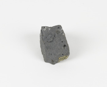
... Olivine is the name of a group of rock-forming silicate minerals with compositions ranging between Mg2SiO4 and Fe2SiO4. Unlike other minerals, Olivine has a very high crystallisation temperature which makes it the first of the minerals to crystallise from magma. ...Olivine is the name of a group of rock-forming silicate minerals with compositions ranging between Mg2SiO4 and Fe2SiO4. Unlike other minerals, Olivine has a very high crystallisation temperature which makes it the first of the minerals to crystallise from magma. ...This particular geological specimen was found in Mount Franklin or Lalgambook in Djadjawurrung, located between Daylesford and Newstead, approximately ninety minutes drive from Melbourne. The mountain is an example of a breached scoria cone (a steep conical hill of loose pyroclastic fragments) which was created by a volcanic eruption about 470,000 years ago, a date which may indicate the age of this geological specimen. The volcanic eruptions of Mount Franklin were most likely witnessed by members of the Dja Dja Wurrung Aboriginal tribe, who referred to this country as the 'smoking grounds'. Mount Franklin and the surrounding area appears to have been a place of considerable religious significance to Aboriginal people, there is evidence which indicates that frequent large ceremonial gatherings took place in the area. Basalt is the most common rock on Earth’s surface, more than 90% of all volcanic rock on Earth is basalt. Basalt is an aphanitic extrusive igneous rock formed from the rapid cooling of low-viscosity lava exposed at or very near the surface of a rocky planet or moon. Specimens are black in colour and weather to dark green or brown. Basalt is rich in iron and magnesium and is mainly composed of olivine, pyroxene, and plagioclase. Olivine is the name of a group of rock-forming silicate minerals with compositions ranging between Mg2SiO4 and Fe2SiO4. Unlike other minerals, Olivine has a very high crystallisation temperature which makes it the first of the minerals to crystallise from magma. As magma cools, the crystals begin to form and settle on the bottom of the lava and form basalts that are abnormally enriched in olivine in the lower part of lava flows. According to H. M. King (on geology.com) "Olivine is thought to be an important mineral in Earth's mantle. Its presence as a mantle mineral has been inferred by a change in the behaviour of seismic waves as they cross the boundary between Earth's crust and mantle". Lava from Mount Franklin and other volcanoes in the area filled valleys and buried the gold bearing streams that became the renowned ‘deep leads’ of the gold mining era. In 1852, as part of the Victorian gold rush, gold was discovered in the immediate area, this gold was created by lava flows during the Newer Volcanic period, which were mined intensively during the nineteenth century. Around 1865 the presence of a deep lead in Mount Franklin was established. Deep lead mining was initially unsuccessful, and it was not until the late 1870s that the Franklinford Gold Mining Company mined at Mount Franklin on a significant scale. A few years later the Mount Franklin Estate Gold Mining Company also struck gold, followed by the Shakespeare and Great Western companies in the mid-1880s. By the late 1880s, however, deep lead mining had ceased in the area. Soon after gold was discovered in 1851, Victoria’s Governor La Trobe wrote to the Colonial Office in London, urging ‘the propriety of selecting and appointing as Mineral Surveyor for this Colony a gentleman possessed of the requisite qualifications and acquaintance with geological science and phenomena’. Alfred Selwyn was appointed geological surveyor in Australia in 1852 which began the Geological Survey of Victoria. In 1853-69 the Geological Survey issued under Selwyn's direction sixty-one geological maps and numerous reports; they were of such high standard that a writer in the Quarterly Journal of the Geological Society of London bracketed the survey with that of the United States of America as the best in the world. During his years spent in Australia, Selwyn collected numerous significant geological specimens, examples of which are held in collections such as the Burke Museum.This geological specimen is an example of basalt and olivine which shows the volcanic lava activity and geographical specific nature of Mt Franklin as a significant volcanic site. According to Agriculture Victoria 'The crater is one of the deepest in the Central Highlands area. It is a major megacryst site with some of the largest known Victorian examples of megacrysts of augite and an orthoclase. The small parasitic mound of Lady Franklin on the western flanks adds to the geological interest of the site'. This specimen also highlights the locality as a significant place for both indigenous activity and Victorian gold rush era mining practices. This specimen is part of a larger collection of geological and mineral specimens collected from around Australia (and some parts of the world) and donated to the Burke Museum between 1868-1880. A large percentage of these specimens were collected in Victoria as part of the Geological Survey of Victoria that begun in 1852 (in response to the Gold Rush) to study and map the geology of Victoria. Collecting geological specimens was an important part of mapping and understanding the scientific makeup of the earth. Many of these specimens were sent to research and collecting organisations across Australia, including the Burke Museum, to educate and encourage further study.An angular, solid hand-sized piece of grey volcanic Basalt with green/brown Olivine phenocrysts along one flat edge.Olivine in basalt / - label is probably / correct. / C. Willman / 15/4/21burke museum, beechworth, indigo shire, beechworth museum, geological, geological specimen, mineralogy, basalt, igneous rock, igneous-volcanic, volcanic geology, volcanic, olivine, olivine specimen, basaltoid -
 The Beechworth Burke Museum
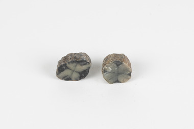
Geological specimen - Chiastolite
... rock-forming mineral, sometimes found in granite or schist. It is often used to make glass, ceramic products, chemicals, and heat-resistant bricks as it can withstand high temperatures without changing. ...rock-forming mineral, sometimes found in granite or schist. It is often used to make glass, ceramic products, chemicals, and heat-resistant bricks as it can withstand high temperatures without changing. ...It is made up of andalusite. Andalusite is a rock-forming mineral, sometimes found in granite or schist. It is often used to make glass, ceramic products, chemicals, and heat-resistant bricks as it can withstand high temperatures without changing. The chiastolite contains particles of graphite, which arranges in geometric patterns. When crystal growth occurs in the rock, the granite particles concentrate at crystal interfaces and can result in cross shapes. These ‘cross stones’ have been valued and used for their spiritual or religious meaning and used as charms, gems, or amulets. Chiastolite was first discovered in 1754, seen in a description in a published book by a palaeontologist, Franciscan priest, and Spanish author, Jose Torrubia. Deposits have been found in Australia, France, the USA, Chile, Canada, Spain, Brazil, Sri Lanka, and Russia. Deposits have been found in Western Australia and South Australia. This particular specimen was found in Bimbowrie, South Australia. Other chiastolite specimens have been found in Bimbowrie, along with jasper, quartz, and aventurine in the form of rolled pebbles or schist. This chiastolite specimen is socially and historically significant. It is a very rare sort of andalusite mineral. It is from one of only two locations where it is regularly found in Australia. The carbon cross has made it an important religious symbol in the past. Its ability to withstand high temperatures has made it a common ingredient in heat-resistant bricks and ceramics today. This specimen is part of a larger collection of geological and mineral specimens collected from around Australia (and some parts of the world) and donated to the Burke Museum between 1868-1880. A large percentage of these specimens were collected in Victoria as part of the Geological Survey of Victoria that begun in 1852 (in response to the Gold Rush) to study and map the geology of Victoria. Collecting geological specimens was an important part of mapping and understanding the scientific makeup of the earth. Many of these specimens were sent to research and collecting organisations across Australia, including the Burke Museum, to educate and encourage further study.A metamorphic mineral consisting of andalusite, with a cross shaped graphite pattern in colours of grey, brown and yellowburke museum, beechworth, geological, geological specimen, andalusite, chiastolite, geometric, cross stone, spiritual, religious, australia, south australia, bimbowrie, quartz, jasper, aventurine, schist -
 8th/13th Victorian Mounted Rifles Regimental Collection
Photograph
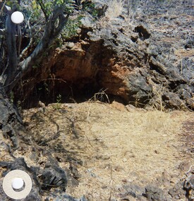
... Two colour photographs of sink holes/rock depressions cbserved while on patrol during Exercise " Northern Explorer. These features offered the only shade when temperature was 41oC....Two colour photographs of sink holes/rock depressions cbserved while on patrol during Exercise " Northern Explorer. These features offered the only shade when temperature was 41oC. ...In 1988, as part of a Defence of Mainland Australian policy, defence of facilities of strategic importance in northern Australia were allocated to Army Reserve units. ‘A’ Squadron was allocated the defence of Tindal Air Force base located 15 KM outside Katherine in Northern Territory. Consequently the Squadron deployed on Exercise ‘Northern Explorer’ to gain first-hand knowledge of operating conditions for mounted and dismounted patrolling in the area.Two colour photographs of sink holes/rock depressions cbserved while on patrol during Exercise " Northern Explorer. These features offered the only shade when temperature was 41oC.