Showing 4 items matching "rockbank inn"
-
 Sunshine and District Historical Society Incorporated
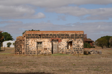
Photograph - Rockbank Inn Photograph, John Alchin, 2007
... Rockbank Inn Photograph......Rockbank Inn...In 1951, further land was lost to the Shire of Melton. The Rockbank Inn built C1853 was located on Beatty's Road, one of the main routes from Melbourne to Ballarat during the gold rush. ...5590.01 - Rockbank Inn Beattys Rd 2007.JPG...Beatty's Road Rockbank Rockbank Inn Beattie 5590.01 - Rockbank Inn Beattys Rd 2007.JPG Digital photograph Photograph Rockbank Inn Photograph John Alchin ...Rockbank was once part of the Braybrook Road District. In 1871, the Road District became the Shire of Braybrook. In 1916, this district was transferred to the Shire of Melton. In 1951, further land was lost to the Shire of Melton. The Rockbank Inn built C1853 was located on Beatty's Road, one of the main routes from Melbourne to Ballarat during the gold rush. In December 1854, troops of the 12th and 40th Regiments marching to suppress the Eureka Stockade stopped at the inn: After the closure of the Inn C1870, it became a residence of the Beattie family for nearly 90 years. The building was then abandoned C1960 and it then fell into ruin. Past owners of the site include: 1840s–1853 William Cross Yuille. Original pastoral run holder. In 1853, he sold of the run to W.C.T. Clarke but retained the 20‑acre inn site. 1853–c.1855 James Stewart & John Brown. Possibly built earliest section of the inn. c.1855–1870 John Gray. Commissioned 1855 bluestone additions; trustees sold in 1870. c.1870–c.1960 Beattie family. Long‑term residents; inn no longer operated as hotel. The Rockbank Inn is one of the few surviving sites directly tied to the Eureka Stockade Rebellion.5590.01 - Rockbank Inn Beattys Rd 2007.JPGbeatty's road, rockbank, rockbank inn, beattie -
 Sunshine and District Historical Society Incorporated
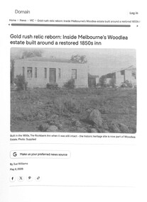
Document - Rockbank Inn Woodlea Estate Rockbank, Sue Williams, 6th May 2026
... Rockbank Inn Woodlea Estate Rockbank...Rockbank Inn...In 1951, further land was lost to the Shire of Melton. The Rockbank Inn built C1853 was located on Beatty's Road, one of the main routes from Melbourne to Ballarat during the gold rush. ...Long‑term residents; inn no longer operated as hotel. Rockbank Inn Beatty's Road Rockbank Gold rush relic reborn: Inside Melbourne’s Woodlea estate built around a restored 1850s inn Digital PDF File Document Rockbank Inn Woodlea Estate Rockbank Sue Williams Domain ...Rockbank was once part of the Braybrook Road District. In 1871, the Road District became the Shire of Braybrook. In 1916, this district was transferred to the Shire of Melton. In 1951, further land was lost to the Shire of Melton. The Rockbank Inn built C1853 was located on Beatty's Road, one of the main routes from Melbourne to Ballarat during the gold rush. In December 1854, troops of the 12th and 40th Regiments marching to suppress the Eureka Stockade stopped at the inn: After the closure of the Inn C1870, it became a residence of the Beattie family for nearly 90 years. The building was then abandoned C1960 and it then fell into ruin. The Inn will become an important land in the new Woodlea residential housing estate. Past owners of the site include: 1840s–1853 William Cross Yuille. Original pastoral run holder. In 1853, he sold of the run to W.C.T. Clarke but retained the 20‑acre inn site. 1853–c.1855 James Stewart & John Brown. Possibly built earliest section of the inn. c.1855–1870 John Gray. Commissioned 1855 bluestone additions; trustees sold in 1870. c.1870–c.1960 Beattie family. Long‑term residents; inn no longer operated as hotel.Gold rush relic reborn: Inside Melbourne’s Woodlea estate built around a restored 1850s innrockbank inn, beatty's road, rockbank -
 Sunshine and District Historical Society Incorporated
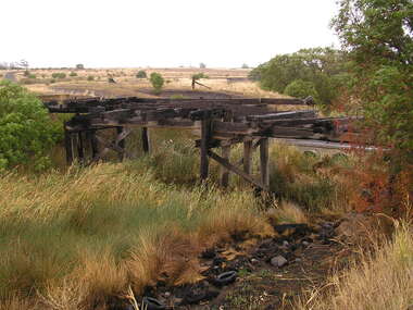
Photograph - Beattys Road Bridge Rockbank Photographs, John Alchin, 2008
... ...Rockbank Inn...In December 1854, troops of the 12th and 40th Regiments marching to suppress the Eureka Stockade would have used this route before stopping at the Rockbank Inn, which was located on Beatty's Road, further west towards Melton. ...In December 1854, troops of the 12th and 40th Regiments marching to suppress the Eureka Stockade would have used this route before stopping at the Rockbank Inn, which was located on Beatty's Road, further west towards Melton. ...Rockbank was once part of the Braybrook Road District. In, 1871 the Road District became the Shire of Braybrook. In 1916, this district was transferred to the Shire of Melton. In 1951, further land was lost to the Shire of Melton. During the early days of the Ballarat gold rush, Beatty's Road was one of the main routes from Melbourne to Ballarat via Keilor . In December 1854, troops of the 12th and 40th Regiments marching to suppress the Eureka Stockade would have used this route before stopping at the Rockbank Inn, which was located on Beatty's Road, further west towards Melton. One of the photographs captures a Terrestrial Road surface (Local Blue Stone), one of the district's early sealed section of road. 5644.01 - Beattys Road Bridge Rockbank 2008 Photo 01.JPG 5644.02 - Beattys Road Bridge Rockbank 2008 Photo 02.JPG 5644.03 - Beattys Road Terrestrial Road Surface Rockbank 2008 Photo 04.JPG 5644.04 - Beattys Road Paddocks Rockbank 2008 Photo 03.JPGbeatty's road, rockbank, rockbank inn, terrestrial road -
 Sunshine and District Historical Society Incorporated
Document - Shire Of Melton Heritage Study Environmental History 2007, David Moloney, May 2007
... ...Rockbank Inn...Mention in this document includes Charles Grimes and John Batman, two of the district's early explorers, the local aborigine clans, Kororoit Creek, Keilor Plains, Rockbank Inn and the Rockbank Beam Wireless Station. ...The Braybrook Road Board proclaimed on the 28th May 1860, and subsequently on the 23rd January 1871, renamed to The Shire of Braybrook. The Braybrook Roads Board and Shire of Braybrook were the earliest form of local government for the entire district that later became Sunshine, and its jurisdiction originally stretched all the way west to Toolern Creek near present‑day Melton. This means that much of what we now think of as “East Melton” and “Rockbank” was once governed from Braybrook.Mention in this document includes Charles Grimes and John Batman, two of the district's early explorers, the local aborigine clans, Kororoit Creek, Keilor Plains, Rockbank Inn and the Rockbank Beam Wireless Station.Shire Of Melton Heritage Study Environmental History David Maloney May 2007charles grimes, kororoit creek, derrimut, first nation, aboriginal, aborigine, hume and hovell, rockbank inn, keilor plains, john batman, rockbank, rockbank wireless station