Showing 1009 items matching rocky%20mountain%20mining%20company
-
 Kiewa Valley Historical Society
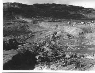
Photograph of Rocky Valley, Rocky Valley showing Dam Excavation, c1948-1951
This photograph was taken during construction of the Rocky Valley Dam and wall. Work was commenced in early 1947 but had to be suspended during winter and then resumed in October. Work continued in 1948 with the establishment of work facilities and, at the dam site, the river was diverted through a temporary pipeline. Rocky Valley and associated spillway and outlet works were completed in 1959.A pictorial record of the construction of the rock and earth filled dam wall at Rocky Valley. Shows the extent of the project undertaken and the fact that a lot of the work was done manually by pick and shovel - note the workmen using picks and sledge hammers on the lower half of the photo.A black and white photograph showing the excavation of the dam at Rocky Valley looking towards Heathey's SpurHand written on the back of photograph in blue ink "Rocky Valley showing dam excavation" rocky valley, dam, wall, picks, sledge hammers -
 Kiewa Valley Historical Society
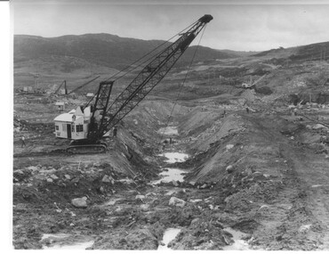
Photograph Rocky Valley Dam Excavations, Rocky Valley Dam Wall Excavation, c1947-48
Work commenced at Rocky Valley Dam site in early 1947 and proceeded until May. Resumed work in October after the winter and a camp for the accommodation of workmen was commenced at this time. Work continued in 1948 with the establishment of work facilities, including the erection of two large excavators. At the dam site the river was diverted through a temporary pipeline. Work proceeded in the summer months with the placing of concrete in the foundations and earth and rock fill for the construction of the wall. Rocky Valley and associated spillway and outlet works were completed in March, 1959. A very good representation of the type of machinery available in the 1940's used for excavation of the dam and the construction of the dam wall.Black and white photograph of Rocky Valley Dam wall under construction. There are at least three cranes plus workmen in the photo. This is taken from the Heathey's Spur side of the dam wall looking back toward Sun Valley.Hand written on back of photograph "Rocky Valley Dam Wall Excavation" in blue ink.rocky valley, dam, wall, machinery -
 Port Fairy Historical Society Museum and Archives
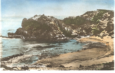
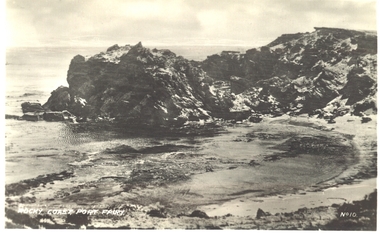
Photograph - Postcard, Rocky Coast. Port Fairy
Hand coloured photograph of a rocky outcrop above a small sandy cove Rocky coast Port Fairy No !0beach, sea, seascape -
 Falls Creek Historical Society
Photograph - Building Rocky Valley Dam Wall
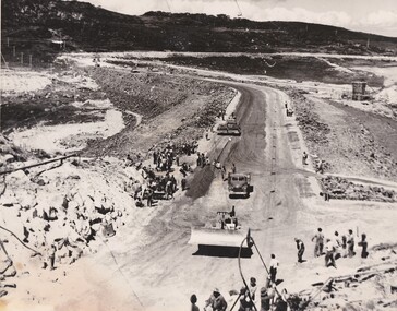
The Rocky Valley Dam is located on the Bogong High Plains, near Falls Creek, Victoria. The dam is man-made and has a capacity of 28,000 megalitres (990×106 cu ft). At an elevation of 1600m, Rocky Valley Dam is the highest significant body of water in Australia. The dam was created for the Kiewa Hydroelectric Scheme. Just a short distance from the heart of the village, the lake provides a playground for a range of aquatic activities. It is also utilised in snow making for the Falls Creek ski resort. Work began on the Rocky Valley Dam site in early 1947 and continued until May. It resumed in October after the winter and a camp for the accommodation of workmen was commenced at this time. Work continued in 1948 with the establishment of work facilities, including the erection of two large excavators. The Rocky Valley Dam was completed in 1959.These images are significant as they capture work carried out to build the wall at Rocky Valley near Falls Creek, VictoriaThree black and white images showing work on the Rocky Valley Dam, Victoriarocky valley dam, kiewa hydroelectric scheme, falls creek -
 Kiewa Valley Historical Society
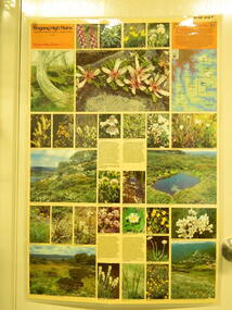
Map / Chart, Vegetation Map & Guide to Alpine Flora: Rocky Valley, 1982
This poster is of Rocky Valley is on the Victorian High Plains where the State Electricity Commission of Victoria worked on the Kiewa Hydro Electric Scheme and also where cattlemen brought their cattle up during summer at various times. Its significance is due to it shows the flora of the area after the Kiewa Hydro Electric Scheme Rocky Valley damn has been build and therefore is a valuable for comparison to see what plants are there now after this information on this poster was complied. Historic: Comparison of the flora at Rocky Valley with other areas on the Victorian High Plains and with Rocky Valley before and after the Kiewa Hydro Scheme and / or grazing there. Is therefore research significance and interpretive capacity due to this compatibility value.Laminated double sided vegetation map and guide to the Alpine flora of the Rocky Valley area, with photographs of plants and vegetation.rocky valley. alpine. flora. vegetation. plants. s.e.c.v.. cattlemen. victorian high plains. -
 Port Fairy Historical Society Museum and Archives
Postcard - Photograph, Rocky Coast, Port Fairy
PhotographRocky Coast, Port Fairybeach, sea, seascape -
 Falls Creek Historical Society
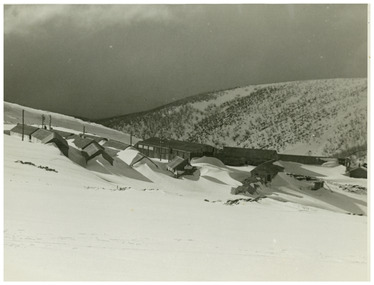
Photograph - Rocky Valley Camp
MEYER COLLECTION - FALLS CREEK PHOTOS In 1947 a determined group of like-minded State Electricity Commission (SEC) staff including Ray Meyer, the chief surveyor of the Kiewa Hydro-Electric Scheme, had a common interest that revolved around the skiing potential of the snow-covered high plains which included what is now the resort of Falls Creek. The six SEC employees, Toni St Elmo, Ray Meyer, Jack Minogue, Lloyd Dunn, Adrian Ruffenacht and Dave Gibson (together with their families) banded together to secretly build a 'hut' that was the first ski lodge at Falls Creek. Using a road built in 1930s to gain access to Falls Creek, their hut project was carried out in secret as efforts by other skiers were blocked by H.H.C. Williams – the engineer in charge of the Hydro Scheme. In 1946 Ray Meyer made a trip to the Lands Office in Melbourne. He came away with a 99-year lease on three acres that was ideally suited for a hut designed by Lloyd Dunn. Adrian Ruffenacht (Design Engineer for the KHS) had suggested where the group should build because of easy access to a spring for water. Much of the building material required was scavenged from derelict huts on the high plains. Due to the need for secrecy, the determined group worked on the hut in the evenings and weekends to avoid detection. During the building period the group had met at Echidna Rock (now known as Eagle Rock) where Skippy St Elmo announced, "This is my favourite ‘Skyline’.” And so the first lodge in the area at Falls Creek Ski Resort came into existence. With the development of the International Poma in the 1970s, the Skyline Lodge, which was sited between the ski-lift’s pole one and pole two, was demolished. However, the legacy of Ray Meyer, Toni St Elmo, Jack Minogue, Lloyd Dunn, Adrian Ruffenacht and Dave Gibson and Skyline lives on in the vibrant atmosphere of Falls Creek Resort. The MEYER COLLECTION documents developments on the Kiewa Hydro Scheme and their life at Falls Creek from the mid 1930s to 1960s.This image is significant because it documents the development of the Kiewa Hydroelectric Scheme.A black and white image of Rocky Valley Camp. Work began on the Rocky Valley Dam site in early 1947 and continued until May. It resumed in October after the winter and a camp for the accommodation of workmen was commenced at this time. Work continued in 1948 with the establishment of work facilities, including the erection of two large excavators. The Rocky Valley Dam was completed in 1959.ray meyer, blairs hut, falls creek, victorian snowfields -
 Falls Creek Historical Society
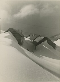
Photograph - Rocky Valley Camp, c1949
MEYER COLLECTION - FALLS CREEK PHOTOS In 1947 a determined group of like-minded State Electricity Commission (SEC) staff including Ray Meyer, the chief surveyor of the Kiewa Hydro-Electric Scheme, had a common interest that revolved around the skiing potential of the snow-covered high plains which included what is now the resort of Falls Creek. The six SEC employees, Toni St Elmo, Ray Meyer, Jack Minogue, Lloyd Dunn, Adrian Ruffenacht and Dave Gibson (together with their families) banded together to secretly build a 'hut' that was the first ski lodge at Falls Creek. Using a road built in 1930s to gain access to Falls Creek, their hut project was carried out in secret as efforts by other skiers were blocked by H.H.C. Williams – the engineer in charge of the Hydro Scheme. In 1946 Ray Meyer made a trip to the Lands Office in Melbourne. He came away with a 99-year lease on three acres that was ideally suited for a hut designed by Lloyd Dunn. Adrian Ruffenacht (Design Engineer for the KHS) had suggested where the group should build because of easy access to a spring for water. Much of the building material required was scavenged from derelict huts on the high plains. Due to the need for secrecy, the determined group worked on the hut in the evenings and weekends to avoid detection. During the building period the group had met at Echidna Rock (now known as Eagle Rock) where Skippy St Elmo announced, "This is my favourite ‘Skyline’.” And so the first lodge in the area at Falls Creek Ski Resort came into existence. With the development of the International Poma in the 1970s, the Skyline Lodge, which was sited between the ski-lift’s pole one and pole two, was demolished. However, the legacy of Ray Meyer, Toni St Elmo, Jack Minogue, Lloyd Dunn, Adrian Ruffenacht and Dave Gibson and Skyline lives on in the vibrant atmosphere of Falls Creek Resort. The MEYER COLLECTION documents developments on the Kiewa Hydro Scheme and their life at Falls Creek from the mid 1930s to 1960s.This image is significant because it depicts aspects of the development of the Kiewa Hydroelectric Scheme.A black and white image of Rocky Valley Camp. Work began on the Rocky Valley Dam site in early 1947 and continued until May. It resumed in October after the winter and a camp for the accommodation of workmen was commenced at this time. Work continued in 1948 with the establishment of work facilities, including the erection of two large excavators. The Rocky Valley Dam was completed in 1959.falls creek, victorian snowfields, rocky valley camp -
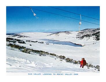 Falls Creek Historical Society
Postcard - Sun Valley, Looking to Rocky Valley Dam
These photographs were taken in and around Falls Creek by Samuel Keith Pearce and printed for him as a foldout postcard by NuColor Vue. The postcards state they were printed for S. K. Pearce Pty. Ltd of Tawonga and Mount Beauty. Samuel Keith Pearce was born on 24 June 1917 in Armadale, Victoria. By the late 1940s he owned the Mt Beauty Supermarket, Newsagency, Drapery and Hardware store at Mount Beauty and also a store at Tawonga in partnership with his brother Gordon Cathew Pearce. For some time, they operated as Pearce Brothers. In the early 1960s Keith also opened a mini mart In Falls Creek. As well as being a keen photographer and an astute businessman, Keith Pearce was a well-known identity in the Kiewa Valley, making many contributions to the development of the area over a long period. This included serving as a member of the Bright Shire Council for many years. He worked hard to promote the interests of the Upper Kiewa Valley. As a sign of recognition and appreciation for his contribution to the community, the park opposite the grocery store in Mount Beauty was named the SK Pearce Gardens in his honour. Samuel Keith Pearce died on 7 July 1994 in Mount Beauty, VictoriaThis collection of postcards and image is significant because they were commissioned by a highly successful business in Falls Creek, Victoria.A high definition photo of the skiers at Sun Valley with Rocky Valley Dam in the background. Rocky Valley Dam is man-made and has a capacity of 28,000 megalitres. It was created for the Kiewa Hydroelectric Scheme and is also utilised in snow making for Falls Creek.falls creek resort, sun valley tow, rocky valley dam, hydroelectricity -
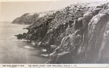 Phillip Island and District Historical Society Inc.
Photograph, Rocky coast, Cape Woolamai
Part of a collection of 'Rose & Valentine' series of Post Cards. Copied by John Jansson 1984View of Cape Woolamai showing the rugged nature of the coastline. Calm seas.The Rose Series P.10449. The Rocky Coast, Cape Wollomai, Phillip Island Victorialocal history, photography, photographs, postcards, cape woolamai, phillip island, black & white postcard copy, coastline -
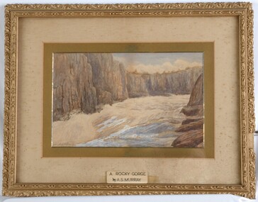 Glenelg Shire Council Cultural Collection
Painting, A.S. Murray, A Rocky Gorge, n.d
CEMA Art collection Previously located in History HouseThe painting portrays a gorge from the perspective of being in the gorge and looking towards the shore. In the foreground is a small body of water with large brown rocks to the right. Yellow sand extends from the rocks around to the left of the water. The sand stretches from the water's edge to the large cliffs in the background that form the borders of the gorge. The work is mounted and framed in an ornate gilded frame with glass.Front: A.S.Murray (signature lower left) A ROCKY GORGE by A.S.MURRAY (sticker - lower centre on glass) Back: 3132 (small yellow sticker) -
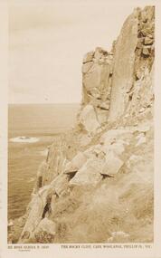 Phillip Island and District Historical Society Inc.
Sepia Photograph, 1920's
This album was presented to the Earl of Stradbroke by the Fathers of Soldiers and Returned Soldiers 16/02/1923. Photo of rocky cliff at Cape Woolamai with Bass Strait in background.Photograph of rocky cliff at Cape Woolamai, Phillip Island.Rose Series P 3439. The Rocky Cliff, Cape Woolamai, Phillip Is., Vic.phillip island, cape woolamai, rocky cliffs at cape woolamai, earl of stradbroke -
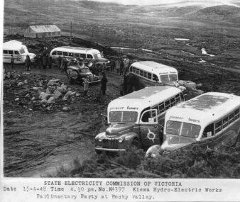 Kiewa Valley Historical Society
Photograph - Parlimentary Party visiting Rocky Valley Dam site, 15-4-1948
This photograph was taken during construction of the Rocky Valley Dam and wall. Work was commenced in early 1947 but had to be suspended during winter and then resumed in October. Work continued in 1948 with the establishment of work facilities and, at the dam site, the river was diverted through a temporary pipeline. Rocky Valley and associated spillway and outlet works were completed in 1959.A pictorial record of the construction of the rock and earth filled dam wall at Rocky Valley. Shows the extent of the project undertaken and the level of importance of the project as indicated by the large representation at the parliamentary party visit on 15/4/48.Photocopy of black and white photograph of parliamentary party visiting Rocky Valley Dam site 15/04/1948Typed on the bottom of photocopy - State Electricity Commission of Victoria. Date: 15-4-48 Time: 4.30pm No: K4397. Kiewa Hydro-Electric works. Parlimentary Party at Rocky Valleyrocky valley dam, parliamentary party, secv -
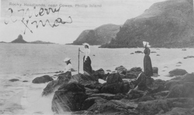 Phillip Island and District Historical Society Inc.
Photography, Fishing on rocky headland
Part of collection of Rose & Valentine Series of Postcards - Copied by John Jansson 1984Black & White Postcard. Picnic party on rocks looking towards Pyramid Rock. CopyRocks Headlands near Cowes, Phillip Island. over printed "A Merry Xmas"local history, photography, photographs, postcards, views phillip island, picnic party, beach rocks, pyramid rock, phillip island -
 Federation University Historical Collection
Photograph - Colour, Chatham-Holmes Collection: Elizabeth and Philip Chatham, dry rocky area
chatham-holmes collection, elizabeth chatham, philip chatham -
 Stawell Historical Society Inc
Book - Report, Grampians: A Report on recreation and Timber Uses of. Too Steep to Graze - Too Rocky to Plough, 1979
1) Conservation & Economics 2) Grampians Study Area 3) Land Use 4) Management 5) Criticisms of the Management Plan Appendix Graphs & MapsGreen Paper cover: Black tape on SpineConservation council of Victoria and Logo -
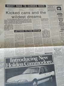 Peterborough History Group
Newspaper - Newspaper article ab out the road the The Lodge fishing spot, Rocky road to Curdies River
The fishing spot known as The Lodge was accessed, for many years, via private property. This article is about an on site meeting, who attended and what was said in regards to the upgrading of a road for access to the river. Includes a letter to the Editor from Ronald Irvine stating their position. Enquiries made on March 11th 2021 with Ronald Irvine revealed that the road had deteriorated and vehicles were becoming bogged, requiring the farmer to pull them out with a tractor. Council were reluctant to fund repairs and the result was that the gate was locked and public access no longer available.Significant because it is a record of community and government discussion about community access to a popular fishing location on the Curdies River.Two page newspaper article from the Cobden Times March 5 1986peterborough, curdies river, the lodge, ronald irvine, the lodge fishing, timboon anglers club, john irvine, the cobden times, 5 march 1986 -
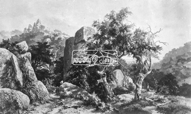
![Watercolour on paper, Neville Bunning, [Rocky Landscape]](https://victoriancollections.net.au/media/collectors/530576742162ef0fa09a2288/items/534748169821f420f8c0373a/item-media/5388204b2162ef1ba88bb56f/item-fit-380x285.jpg) Federation University Art Collection
Federation University Art CollectionWatercolour on paper, Neville Bunning, [Rocky Landscape]
This item is part of the Federation University Art Collection. The Art Collection features over 1000 works and was listed as a 'Ballarat Treasure' in 2007.Four landscapes framed together.art, artwork, neville bunning, landscape -
 Eltham District Historical Society Inc
Photograph, Rocky Outcrop
A rural location with a visible exposure of bedrock surrounded by vegetation and trees. A rock exposed high hill is in the background. The location and artist are unidentified. The location is reminscent of Hanging Rock, Woodend.This photo forms part of a collection of photographs gathered by the Shire of Eltham for their centenary project book, "Pioneers and Painters: 100 years of the Shire of Eltham" by Alan Marshall (1971). The collection of over 500 images is held in partnership between Eltham District Historical Society and Yarra Plenty Regional Library (Eltham Library) and is now formally known as 'The Shire of Eltham Pioneers Photograph Collection.' It is significant in being the first community sourced collection representing the places and people of the Shire's first one hundred years.Digital imagesepp, shire of eltham pioneers photograph collection, other areas, rocks, bedrock, unknown -
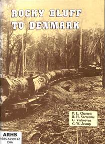 Victorian Railway History Library
Book, Light Railway Research Society of Australia et al, Rocky Bluff to Denmark, 1978
The Light Railway Research Society of Australia's book on the Rocky Bluff to Denmark timber Tramway in Queensland.ill, maps, p.65.non-fictionThe Light Railway Research Society of Australia's book on the Rocky Bluff to Denmark timber Tramway in Queensland.light railways - australia - history, railroad operations - australia - history -
Glenelg Shire Council Cultural Collection
Photograph - Photograph - Cape Bridgewater, n.d
Black and white photo. Waves breaking against rocky cliffs at Cape Bridgewater.Back: 'Rocky Shore & Stormy sea - Cape Bridgewater' - handwritten, black ink. '8' - pencilcoastline, cape bridgewater, south west coastline -
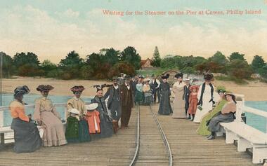 Phillip Island and District Historical Society Inc.
Photograph - Post Cards, Vallentines, Phillip Island
Three coloured Postcards from Mary Karney's collection.Three coloured Postcards, Cowes Pier, Rocky Headlands near Cowes and On the Beach at Cowes.450-37: Waiting for the Steamer on the Pier at Cowes, Phillip Island. 450-38: Rocky Headlands near Cowes, Phillip Island. 450:39: On The Beach at Cowes, Phillip Island. cowes pier phillip island, cowes beach, phillip island foreshore, mary karney -
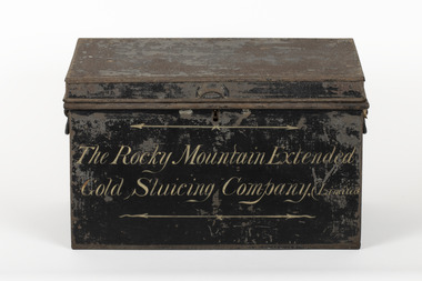 The Beechworth Burke Museum
Container - Trunk, c1870
A tin trunk used by the Rocky Mountain Extended Sluicing Company (Limited).Mining played an important role in the history of Beechworth, for the township was established in the mid-1850s after gold was discovered in the area. The success of goldmining lead to the growth and development of early Beechworth. The Rocky Mountain Company was a very successful gold mining company and had a big impact on the people and landscape of early Beechworth.A tin trunk painted in black with gold script painted on the front.The Rocky Mountain Extended / Gold Slucing Company. (Limited / BMM 8068 -
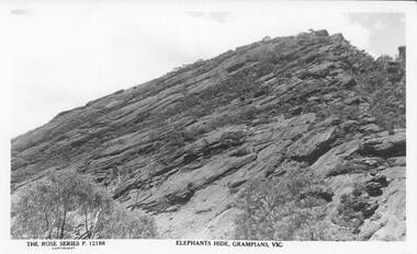 Halls Gap & Grampians Historical Society
Postcard - B/W
Rocky outcrop is known as the "Elephant's Hide' part of the Wonderland Range.Photo shows rocky outcrop with some vegetation and two larger gumtrees in foreground.The Rose Series P12198. Elephant's Hide,Grampians,Vic(on front) Post Card,a Real Photograph,produced in Australia(on back)scenery, wonderland range -
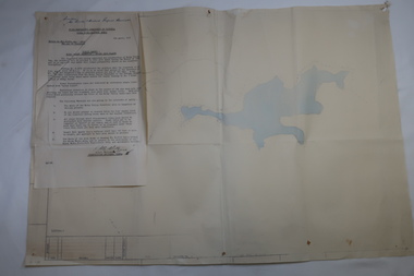 Kiewa Valley Historical Society
Plan Ref. K. 6612 with Letter attached re Public Safety in Kiewa Works Area
The SECV constructed the Kiewa Hydro Electric Scheme which included the building of Rocky Valley Dam on the Bogong High Plains near Falls Creek. H.H.C. Williams, construction engineer, Kiewa wrote to the Ski Clubs at Falls Creek outlining the dangers arising with the filling of Rocky Valley Dam. He lists 5 warnings in the interest of safety.The plan and letter provide the dates for the completion of Rocky Valley dam and its effect on the people living and working in the area including miners and ski clubs. It describes some of the features of Kiewa Works Area at the time.Plan No. K 6612 of Fall Creek showing Rocky Valley Dam's shape when it is full. Letter dated 6th April 1959 from H.H.C. Williams to Ski Clubs at Falls Creek re public safety as Rocky Valley fills. Refers to roads, transmission lines, pole lines etc in the Kiewa Works Area.Written in ink at top of letter - "Secretary / Mt Beauty and District Progress Association"rocky valley dam, falls creek ski clubs, h.h.c. williams, khes 1959, safety -
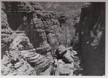 Halls Gap & Grampians Historical Society
Photograph - B/W, C 1960s
Rocky gorge is known as The Grand Canyon, part of the Wonderland/ Pinnacle walking track.Photo shows a rocky gorge. Aroad can be seen through bushland in the background. Two figures can be seen middle foreground about to climb a ladder to higher level . A handrail is visible on the track above the hikers.Copyright photograph. This photograph may be reproduced on condition that it is acknowledged as " Victorian Railways'.scenery, wonderland range -
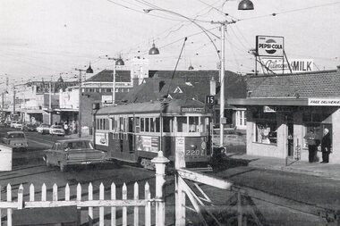 Melbourne Tram Museum
Photograph - Illustration/s, Jul. 1967
Illustration from a printed publication glue to a sheet of paper. Photo graph of W2 220 on Moreland Rd stub terminus, near Brunswick depot. Dated 7/1967 Tram has the destination of South Melbourne, route 15. On the right is Rocky's Milk bar advertising Pepsi Cola and Gilmore's Milk. In the foreground are the railway gates and the level crossing.in ink on rear ""W2 220 (7/67) Old Moreland Rd stub Melbourne (Far Right "Rocky's Milk bar Col's 1st milk share!!)"trams, tramways, w2 class, moreland rd, route 15, tram 220 -
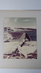 Kiewa Valley Historical Society
Photo - Rocky Valley Dam
The State Electricity Commission of Victoria constructed the Kiewa Hydro Electric Scheme on the Bogong High Plains. The scheme consisted of storage dams and pondages, aqueducts, tunnels, pipelines, transmission lines and three power stations.. Rocky Valley dam was the biggest storage and the last to be completed.Rocky Valley dam was the largest storage within the Kiewa Hydro Electric Scheme. Begun in 1954 and completed in 1960. It was linked to McKay Creek Power StationColoured photo attached to cream cardboard. The background shows hills and the foreground a sign "Rocky Valley Dam ..." The middle shows the dam with water and its bank. There is snow on the ground.rocky valley dam, kiewa hydro electric scheme, secv -
 Ballarat Heritage Services
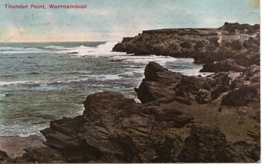
Postcard, Thunder Point, Warrnambool
A rocky beach scene at Warrnambool.warrnambool, thunder point, beach -
 Phillip Island and District Historical Society Inc.
Photograph, Bryant West
One of a collection of over 400 photographs in an album commenced in 1960 and presented to the Phillip Island & Westernport Historical Society by the Shire of Phillip IslandPhotograph of Rocky south coast shoreline.local history, photography, photographs, coastline, phillip island, southern coastline phillip island, john jenner, bryant west