Showing 615 items matching "route map"
-
 Moorabbin Air Museum
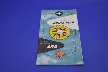
Pamphlet (item) - Australian National Airlines (ANA), Fold Out Route Map
... Australian National Airlines (ANA), Fold Out Route Map....Australian National Airlines (ANA), Fold Out Route Map....Australian National Airlines (ANA), Fold Out Route Map....Moorabbin Air Museum Moorabbin Airport 12 First Street Moorabbin melbourne Australian National Airlines (ANA), Fold Out Route Map. Australian National Airlines (ANA), Fold Out Route Map. ... -
 Moorabbin Air Museum
Map (Item) - Ansett Route Map - Broken Hill <> Alice Springs
... Ansett Route Map - Broken Hill <> Alice Springs...Ansett Route Map - Broken Hill <> Alice Springs...Moorabbin Air Museum Moorabbin Airport 12 First Street Moorabbin melbourne Ansett Route Map - Broken Hill <> Alice Springs Map Ansett Route Map - Broken Hill <> Alice Springs ... -
Moorabbin Air Museum
Map (Item) - BOAC Britannia Fleet London to Colombo Route Map BA774
... BOAC Britannia Fleet London to Colombo Route Map BA774 ...BOAC Britannia Fleet London to Colombo Route Map BA774 ...Moorabbin Air Museum Moorabbin Airport 12 First Street Moorabbin melbourne BOAC Britannia Fleet London to Colombo Route Map BA774 Map BOAC Britannia Fleet London to Colombo Route Map BA774 ... -
 Melbourne Tram Museum
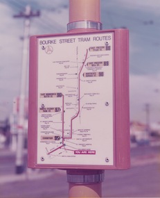
Photograph - Tram stop route map
... Tram stop route map...route map...Photograph is a close-up of an orange and white tram route map on a pole at the corner of Bourke Street and Russell Street. ...Yields information about Melbourne tramway stops and passenger information route map East Brunswick East Preston Bourke Street more tramway patronage Russell Street Colour print with no note on the rear Photograph Tram stop route map ...Photograph is a close-up of an orange and white tram route map on a pole at the corner of Bourke Street and Russell Street. The map shows the routes to East Brunswick and East Preston with intermediate route numbers, major locations and railway stations. Such signs were part of a program to encourage more tramway patronage.Yields information about Melbourne tramway stops and passenger informationColour print with no note on the rearroute map, east brunswick, east preston, bourke street, more tramway patronage, russell street -
 Melbourne Tram Museum
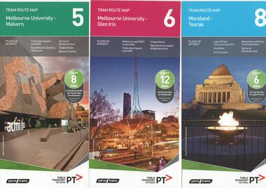
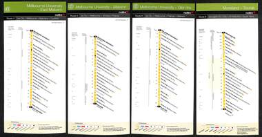
Ephemera - Tram Route Guides, Public Transport Victoria (PTV), "Tram Route Map", 11/2014 to 6/2015
... "Tram Route Map"...Set of 19 Tram Route Maps, published during 2014 and 2015. ..."Tram Route Map" Ephemera Tram Route Guides Public Transport Victoria (PTV) ...Each comprises a vertical DL folded sheet, full colour for the nominated routes, with Yarra Trams and PTV logos, listing the stops, interchanges with bus and other tram services, ticketing zones, estimated frequencies with adverts for Night tram services, TramTracker and Myki tickets. 1 - Route 5 - Melbourne University to Malvern 2 - Route 6 - Melbourne University to Glen Iris 3 - Route 8 - Moreland to Toorak 4 - Route 11 - West Preston - Victoria Harbour Docklands 5 - Route 19 - North Coburg - Flinders St Station 6 - Route 70 - Wattle Park to Waterfront City Docklands 7 - Route 72 - Melbourne University to Camberwell 8 - Route 1 - East Coburg - South Melbourne Beach 9 - Route 3 and 3A - Melbourne University to East Malvern 10 - Route 16 - Melbourne University to Kew 11 - Route 55 - West Coburg - Domain Interchange 12 - Route 57 - West Maribyrnong - Flinders St Station 13 - Route 59 - Airport West - Flinders St. Station 14 - Route 64 - Melbourne University - East Brighton 15 - Route 67 - Melbourne University - Carnegie 16 - Route 78 - North Richmond - Balaclava via Prahran 17 - Route 82 - Footscray - Moonee Ponds 18 - Route 48 - Victoria Harbour to North Balwyn 19 - Route 109 - Box Hill - Port Melbourne See Reg Item 2396 for 2012, 2278 for 2016 and 2940 for 2014 versionsDemonstrates PTV work in providing printed route mapsSet of 19 Tram Route Maps, published during 2014 and 2015. trams, tramways, timetables, maps, route 1, route 3, route 5, route 6, route 8, route 11, route 16, route 19, route 55, route 57, route 59, route 64, route 67, route 70, route 72, route 78, route 82, east coburg, south melbourne, east malvern, kew, west coburg, west maribyrnong, airport west, east brighton, carnegie, north richmond, balaclava, footscray, moonee ponds, malvern, glen iris, moreland, west preston, north coburg, wattle park, camberwell, route 48, north balwynp, box hill -
 Melbourne Tram Museum
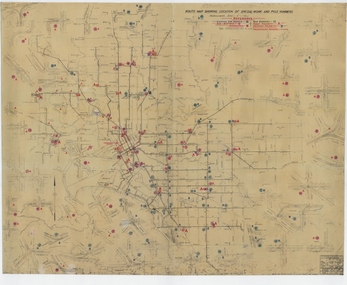
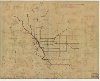
Drawing, Melbourne & Metropolitan Tramways Board (MMTB), "Route Map showing location of special work and pole numbers" "substations", late 1942
... "Route Map showing location of special work and pole numbers" "substations"...Drawing - dyeline cloth backed print - titled - "Route Map showing location of special work and pole numbers" and subtitled - "Substations". ..."Route Map showing location of special work and pole numbers" "substations" Drawing Melbourne & Metropolitan Tramways Board (MMTB) ...Map of the system shown at two inches = 1 mile. Drawing No. P5799. Shows crossovers, track layouts at junctions, signal cabins roads, railways, and stations. Originally signed by Perway Engineer - 20/12/1940, though originally drawn in 1922. The plan shows the lines to Maribyrnong Munitions works along Cordite Ave and Wests Road and the track from Moonee Ponds to Union Road, opened in July 1941, and the extension to Essendon Airport built in 1942, but not the Queen St North Essendon substation. Shows underground cables, tram and bus depot, workshop locations, and substation locations and their priority.Yields information about the MMTB substation locations in 1942.Drawing - dyeline cloth backed print - titled - "Route Map showing location of special work and pole numbers" and subtitled - "Substations". trams, tramways, mmtb, trackwork, tramways, junction, map, world war 2, substation -
 Melbourne Tram Museum
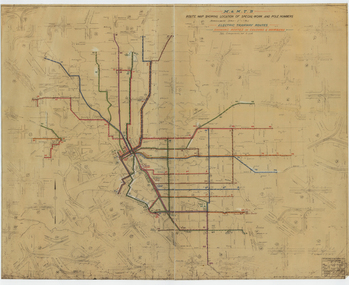
Drawing, Melbourne & Metropolitan Tramways Board (MMTB), "Route Map showing location of special work and pole numbers" "All night tram routes in colours", late 1941
... "Route Map showing location of special work and pole numbers" "All night tram routes in colours"...Map of the system shown at two inches = 1 mile. Drawing No. P5799. Shows crossovers, track layouts at junctions, signal cabins roads, railways, and stations. Originally signed by Perway Engineer - 20/12/1940, though originally drawn in 1922. Has been marked up in colour pencil to show the all-night routes...Drawings - dyeline cloth-backed print - titled - "Route Map showing the location of special work and pole numbers" and subtitled - "All night tram routes in colours". ..."Route Map showing location of special work and pole numbers" "All night tram routes in colours" Drawing Melbourne & Metropolitan Tramways Board (MMTB) ...Map of the system shown at two inches = 1 mile. Drawing No. P5799. Shows crossovers, track layouts at junctions, signal cabins roads, railways, and stations. Originally signed by Perway Engineer - 20/12/1940, though originally drawn in 1922. Has been marked up in colour pencil to show the all-night routes and the individual services. The plan shows the lines to Maribyrnong Munitions works along Cordite Ave and Wests Road and the track from Moonee Ponds to Union Road, opened in July 1941, but not the extension to Essendon Airport built in 1942.Demonstrates a detail drawing of Melbourne tramways, junctions and pole numbers.Drawings - dyeline cloth-backed print - titled - "Route Map showing the location of special work and pole numbers" and subtitled - "All night tram routes in colours". trams, tramways, mmtb, trackwork, tramways, junction, map, world war 2, night trams -
 Melbourne Tram Museum
Drawing, Melbourne & Metropolitan Tramways Board (MMTB), "Route Map showing location of special work and pole numbers" "Electric Tramway Routes - showing routes in colours and numbers", late 1941
... "Route Map showing location of special work and pole numbers" "Electric Tramway Routes - showing routes in colours and numbers"...Map of the system shown at two inches = 1 mile. Drawing No. P5799. Shows crossovers, track layouts at junctions, signal cabins roads, railways and stations. Originally signed by Perway Engineer - 20/12/1940, though originally drawn in 1922. Has been marked up in coloured pencil to show the routes...Drawings - dyeline cloth backed print - titled - "Route Map showing location of special work and pole numbers" and subtitled - "Electric Tramway Routes - showing routes in colours and numbers". ..."Route Map showing location of special work and pole numbers" "Electric Tramway Routes - showing routes in colours and numbers" Drawing Melbourne & Metropolitan Tramways Board (MMTB) ...Map of the system shown at two inches = 1 mile. Drawing No. P5799. Shows crossovers, track layouts at junctions, signal cabins roads, railways and stations. Originally signed by Perway Engineer - 20/12/1940, though originally drawn in 1922. Has been marked up in coloured pencil to show the routes and route numbers. The plan shows the lines to Maribyrnong Munitions works along Cordite Ave and Wests Road and the track from Moonee Ponds to Union Road, which opened in July 1941, but not the extension to Essendon Airport built-in 1942. See Reg Item 1561 for a 1963 version and 1683 for a 1987 versionDemonstrates the use of a MMTB drawing to show tram routes and their route numbers at the time.Drawings - dyeline cloth backed print - titled - "Route Map showing location of special work and pole numbers" and subtitled - "Electric Tramway Routes - showing routes in colours and numbers". trams, tramways, mmtb, trackwork, tramways, junction, map, world war 2 -
 Melbourne Tram Museum
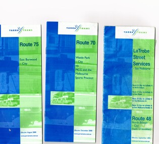
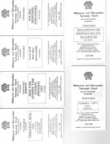
Ephemera - Timetable/s, Yarra Trams, Set of five timetable books - 2002. Provide details about Yarra Trams, Metcards, route map, timing points and route description, 8/2000 to 9/2002
... Provide details about Yarra Trams, Metcards, route map, timing points and route description....Provide details about Yarra Trams, Metcards, route map, timing points and route description. .1 - printed 24 page book, blue green cover stapled timetable for "Route 75 - East Burwood - City" tram service, dated August 2000. .2 - printed 24 page book, blue green cover stapled timetable for "Route 70 - Wattle Park - City" tram service, dated December 2000. .3 - printed 24 page book, blue green cover stapled timetable for "La Trobe Street Services - East Melbourne" and "North Balwyn - City" tram service, dated September 2001. ...Provide details about Yarra Trams, Metcards, route map, timing points and route description. ...Set of five timetable books - 2002. Provide details about Yarra Trams, Metcards, route map, timing points and route description. .1 - printed 24 page book, blue green cover stapled timetable for "Route 75 - East Burwood - City" tram service, dated August 2000. .2 - printed 24 page book, blue green cover stapled timetable for "Route 70 - Wattle Park - City" tram service, dated December 2000. .3 - printed 24 page book, blue green cover stapled timetable for "La Trobe Street Services - East Melbourne" and "North Balwyn - City" tram service, dated September 2001. Covers Route 48, 24, 27, 30 and 34. Has Route 48 on the reverse of the book. .4 - printed 28 page book, blue green cover stapled timetable for "Route 86 - Bundoora / RMIT - Colonial Stadium via Bourke St" tram service, dated September 2002. .5 - printed 32 page book, blue green cover stapled timetable for "Route 109 - Port Melbourne - Mont Albert" and La Trobe St services (back of booklet) tram services, dated September 2001.trams, tramways, tickets, yarra trams, tram services, timetables, la trobe st, route 70, route 75, route 109, route 86, route 86, route 109, route 48, route 24, route 27, route 30, route 34 -
 Ballarat Tramway Museum
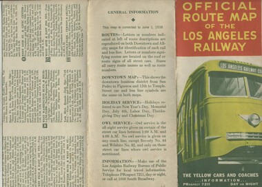
Map, H.P. Noordwal, "Official Route Map of the Los Angeles Railway", Jun. 1938
... "Official Route Map of the Los Angeles Railway"...A (12 section) fold out map of street car (tram) and bus services for Los Angeles, dated June 1, 1938, showing all LAR (Los Angeles Railway) streetcar and coach (tram and bus) services, Pacific Electric lines within area, detailed "downtown" map, route descriptions and points of interest. ...Record images added 20/8/2013. "Official Route Map of the Los Angeles Railway" Map H.P. ...A (12 section) fold out map of street car (tram) and bus services for Los Angeles, dated June 1, 1938, showing all LAR (Los Angeles Railway) streetcar and coach (tram and bus) services, Pacific Electric lines within area, detailed "downtown" map, route descriptions and points of interest. Record images added 20/8/2013.Three terminus have been marked with pencil "X". On rear car, next to object number is a symbol looking like a "H & S" merged together.trams, tramways, los angeles, street cars, map -
Lakes Entrance Historical Society
Booklet - Broadbents Motor Route Map Booklet
... Broadbents Motor Route Map Booklet...Lakes Entrance Historical Society 4 Marine Parade Lakes Entrance gippsland Navigation Accommodation travel Booklet containing maps and information re routes, mileage, hotels, garages between Sydney and Melbourne via Princes Highway Booklet containing maps and information 124 pages Booklet Broadbents Motor Route Map Booklet ...Booklet containing maps and information re routes, mileage, hotels, garages between Sydney and Melbourne via Princes HighwayBooklet containing maps and information 124 pagesnon-fictionBooklet containing maps and information re routes, mileage, hotels, garages between Sydney and Melbourne via Princes Highwaynavigation, accommodation, travel -
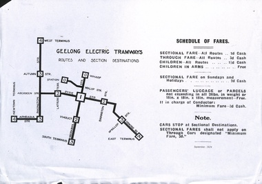 Ballarat Tramway Museum
Sign - Geelong Tramways - Schedule of Fares and route map, State Electricity Commission of Victoria (SECV), 9/1924
... Geelong Tramways - Schedule of Fares and route map...Sign Geelong Tramways - Schedule of Fares and route map State Electricity Commission of Victoria (SECV) ...Sign reset by donor from an original details the routes and sections, fares and luggage charges for Geelong Electric Tramways operated by MESCo dated September 1924. Published prior to the extensions to Eastern Park, Belmont, Chilwell and North. Yields information about the fares and charges and routes operated by MESCo in 1924.Sheet of paper - copy reset from original sign along with composite parts.geelong, tramways, fares, sections, mesco -
Moorabbin Air Museum
Map (Item) - route map of Australia, ANA australian national airways
... route map of Australia...Moorabbin Air Museum Moorabbin Airport 12 First Street Moorabbin melbourne ANA australian national airways Map route map of Australia ... -
 Melbourne Tram Museum
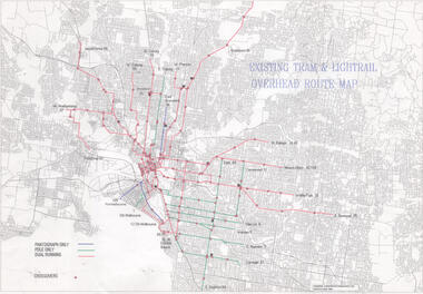
Drawing, Public Transport Corporation (PTC), "Existing tram & Light rail overhead route map", 1996
... "Existing tram & Light rail overhead route map"...Dated 5/6/1996 Demonstrates a PTC document for detailing overhead availability and cross overs. tramways PTC Pantographs Trolley Poles overhead cross overs route numbers tram routes Drawing - Document - folded A3 sheet "Existing tram & Light rail overhead route map" Drawing Public Transport Corporation (PTC) ...Drawings shows on a street plan of Melbourne, tram routes, route numbers location of cross overs, and track availability of pantograph only, pole only and dual running. Dated 5/6/1996Demonstrates a PTC document for detailing overhead availability and cross overs.Drawing - Document - folded A3 sheettramways, ptc, pantographs, trolley poles, overhead, cross overs, route numbers, tram routes -
 Kew Historical Society Inc
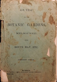
Booklet, Robert S Brain, Guide to the Botanic Gardens Melbourne, with Route Map etc, 1901
... Guide to the Botanic Gardens Melbourne, with Route Map etc...Guide to the Botanic Gardens Melbourne, with Route Map etc Booklet Robert S Brain ...Authorised guide to the Botanic Gardens, Melbourne published by the Government Printer, Victoria. Includes three fold out pages, the first a panoramic photograph, the second a colour map of the Botanic Gardens in 1873 upon the retirement of Baron Von Mueller from the Directorship in 1873 and the third a map of the Botanic Gardens in 1901 showing alterations and improvements since 1873 by W.R. Guilfoyle, Director..Melbourne : Robt. S. Brain, Govt. Printer, [1901] 19 p., [3] folded leaves of plates : ill., plans ; 21 cm. non-fictionAuthorised guide to the Botanic Gardens, Melbourne published by the Government Printer, Victoria. Includes three fold out pages, the first a panoramic photograph, the second a colour map of the Botanic Gardens in 1873 upon the retirement of Baron Von Mueller from the Directorship in 1873 and the third a map of the Botanic Gardens in 1901 showing alterations and improvements since 1873 by W.R. Guilfoyle, Director..botanic gardens -- melbourne (vic.), christian-washfold collection -
 Melbourne Tram Museum
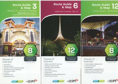
Ephemera - Tram Route Guides, Public Transport Victoria (PTV), "Tram Route Guide and Map", Oct. 13 to July 14
... "Tram Route Guide and Map"...Set of 17 Tram Route Maps, published during 2013 and 2014. Each comprises a vertical DL folded sheet, full colour for the nominated routes, with Yarra Trams and PTV logos, listing the stops, interchanges with bus and other tram services, ticketing zones, estimated frequencies with adverts for Night tram services, TramTracker and Myki tickets. .1 - Route 3 - East Malvern - Melbourne Uni and 3A via St Kilda (Sat and Sun) .2 - Route 6 - Melbourne University to Glen Iris .3 - Route 12 - St Kilda - Victoria Gardens .4 - Route 16 - Kew via St Kilda .5 -Route 30 - St Vincent's Plaza - Etihad Stadium .6 - Route 55 - West Coburg - Domain Interchange .7 - Route 59 - Airport West - City (Elizabeth St) .8 - Route 64 - Melbourne University - East Brighton .9 - Route 70 - Wattle Park to Waterfront City Docklands .10 - Route 75 - Docklands - Vermont South .11 - Route 78 - North Richmond - Balaclava .12 - Route 82 - Moonee Ponds - Footscray .13 - Route 86 - Bundoora - Waterfront City .14 - Route 96 - East Brunswick - St Kilda Beach .15 - Route 109 - Box Hill - Port Melbourne .16 - Route 112 and 11 - West Preston - St Kilda and West Preston - Victoria Harbour Docklands .17 - Route 24 - North Balwyn to Etihad Stadium See Reg Item 2396 for 2012, 2278 for 2016 and 2939 for 2015 versions...Melbourne Tram Museum 8 Wallen Road Hawthorn melbourne Trams tramways Timetables Maps Route 3 Route 6 Route 11 Route 12 Route 16 Route 24 Route 30 Route 55 Route 59 Route 64 Route 70 Route 75 Route 78 Route 82 Route 86 Route 96 Route 109 Route 112 East Malvern Glen Iris Victoria Gardens Kew St Vincent's Plaza West Coburg Airport West East Brighton Wattle Park Vermont South North Richmond Moonee Ponds Footscray St Kilda Docklands West Preston Victoria Harbour North Balwyn Etihad Stadium Set of 17 Tram Route Maps, published during 2013 and 2014. ...Set of 17 Tram Route Maps, published during 2013 and 2014. Each comprises a vertical DL folded sheet, full colour for the nominated routes, with Yarra Trams and PTV logos, listing the stops, interchanges with bus and other tram services, ticketing zones, estimated frequencies with adverts for Night tram services, TramTracker and Myki tickets. .1 - Route 3 - East Malvern - Melbourne Uni and 3A via St Kilda (Sat and Sun) .2 - Route 6 - Melbourne University to Glen Iris .3 - Route 12 - St Kilda - Victoria Gardens .4 - Route 16 - Kew via St Kilda .5 -Route 30 - St Vincent's Plaza - Etihad Stadium .6 - Route 55 - West Coburg - Domain Interchange .7 - Route 59 - Airport West - City (Elizabeth St) .8 - Route 64 - Melbourne University - East Brighton .9 - Route 70 - Wattle Park to Waterfront City Docklands .10 - Route 75 - Docklands - Vermont South .11 - Route 78 - North Richmond - Balaclava .12 - Route 82 - Moonee Ponds - Footscray .13 - Route 86 - Bundoora - Waterfront City .14 - Route 96 - East Brunswick - St Kilda Beach .15 - Route 109 - Box Hill - Port Melbourne .16 - Route 112 and 11 - West Preston - St Kilda and West Preston - Victoria Harbour Docklands .17 - Route 24 - North Balwyn to Etihad Stadium See Reg Item 2396 for 2012, 2278 for 2016 and 2939 for 2015 versionstrams, tramways, timetables, maps, route 3, route 6, route 11, route 12, route 16, route 24, route 30, route 55, route 59, route 64, route 70, route 75, route 78, route 82, route 86, route 96, route 109, route 112, east malvern, glen iris, victoria gardens, kew, st vincent's plaza, west coburg, airport west, east brighton, wattle park, vermont south, north richmond, moonee ponds, footscray, st kilda, docklands, west preston, victoria harbour, north balwyn, etihad stadium -
 Melbourne Tram Museum
Photograph - Black & White Photograph/s of MMTB Map, Melbourne & Metropolitan Tramways Board (MMTB), 1975
... On the rear of the photograph has in pencil "Route Map - MMTB"....Melbourne Tram Museum 8 Wallen Road Hawthorn melbourne Trams tramways Maps Buses MMTB On the rear of the photograph has in pencil "Route Map - MMTB". Black and White Photograph of the MMTB tram and bus services c1975. ...Black and White Photograph of the MMTB tram and bus services c1975. The tram line to East Burwood is not shown. Possibly used in a report 1975 as it shows the urban development in 1945 and 1975.On the rear of the photograph has in pencil "Route Map - MMTB".trams, tramways, maps, buses, mmtb -
 Melbourne Tram Museum
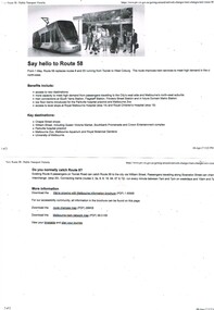
Pamphlet, Public Transport Victoria (PTV), "We're growing with Melbourne", "Say hello to Route 58", Apr. 2017
... ... Route 58... Map...route and all the benefits! .2 - "We're growing with Melbourne" - pamphlet issued by PTV - 6 fold A3 sheet, printed on off white paper, full colour - with changes out lined and a map of Melbourne tram services - see i2 for pdf copy. ...Melbourne Tram Museum 8 Wallen Road Hawthorn melbourne Trams tramways Yarra Trams PTV Route 8 Route 6 Route 55 Route 58 Map Route Guide Set of two black and white pamphlets downloaded from the PTV website, 9/4/2017 regarding the introduction of Route 58, amalgamation of route 55 and 8 on 1/5/17. .1 - "Say hello to Route 58" - two pages going an outline of the new route and all the benefits! ...Set of two black and white pamphlets downloaded from the PTV website, 9/4/2017 regarding the introduction of Route 58, amalgamation of route 55 and 8 on 1/5/17. .1 - "Say hello to Route 58" - two pages going an outline of the new route and all the benefits! .2 - "We're growing with Melbourne" - pamphlet issued by PTV - 6 fold A3 sheet, printed on off white paper, full colour - with changes out lined and a map of Melbourne tram services - see i2 for pdf copy. Two copies held .3 - Pamphlet, printed and cut for use in trams around passenger hanging rails, titled "Say hello to the new Route 58" - on rear gives the new routes and key changes and what to do if you catch route 8? Two copies held - 2 copies held. .4 - Folded DL size sheet - vertical - titled "Tram Route Guide 8 Moreland to Toorak" with a photo of the Shrine of Remembrance on the front. Dated 02/16 - gives a map of all route stops, zones, estimated frequencies, with notes on night services and Myki. .5 - As for .4, but for route 55, with a giraffe on the front, dated 02/16. .6 - Route 58 guide - pending publication at time of entry. There were other service changes as well to other routes. Have Yarra Trams, PTV and State Government logos on the various documents.trams, tramways, yarra trams, ptv, route 8, route 6, route 55, route 58, map, route guide -
 Bendigo Historical Society Inc.
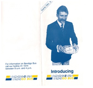
Ephemera - "Bendigo Bus" new routes, 1960 -1970s
... Glossy Brochure introducing "Bendigo Bus" new routes. Map of the new routes and information hotline....History House 11 Mackenzie Street Bendigo goldfields BHS Collection history bendigo merle lummis collection bendigo bus Glossy Brochure introducing "Bendigo Bus" new routes. Map of the new routes and information hotline. ...BHS CollectionGlossy Brochure introducing "Bendigo Bus" new routes. Map of the new routes and information hotline.history, bendigo, merle lummis collection, bendigo bus -
 Wodonga & District Historical Society Inc
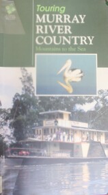
Book - Touring Murray River Country, Stone, Derrick I & Stone, Sascha C, 1996
... A publication of 128 pages includes 230 full colour photos, 42 illustrations and 19 colour route maps. ...A publication of 128 pages includes 230 full colour photos, 42 illustrations and 19 colour route maps. Touring Murray River Country Book Touring Murray River Country Stone, Derrick I & Stone, Sascha C ...A touring guide of the Murray RIver, Australia from its source in the mountains following its journey to the sea. The first sections cover information about the area of the Upper Murray, including Lake Hume and the Albury-Wodonga area.A publication of 128 pages includes 230 full colour photos, 42 illustrations and 19 colour route maps. A touring guide of the Murray RIver, Australia from its source in the mountains following its journey to the sea. The first sections cover information about the area of the Upper Murray, including Lake Hume and the Albury-Wodonga area.murray river, australia - tourism -
 Bendigo Historical Society Inc.
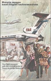
Map - TRANS AUSTRALIAN AIRLINES - ROUTE MAPS, 1950s
... Map. Route maps and flight information for Trans Australian Airlines. ...Map TRANS AUSTRALIAN AIRLINES - ROUTE MAPS ...Map. Route maps and flight information for Trans Australian Airlines. Fold out pamphlet includes brief information about major Australian towns and cities.map, flight map, trans australian airlines, taa -
 Melbourne Tram Museum
Ephemera - Tram Route Guides, Metlink, Set of 12 Metlink route maps, c2008?
... Possibly produced before the route maps at Reg item 2443, not dated. Route 3, 5, 6, 8, 16, 19, 57, 59, 64, 67, 72, 78, 79,...Possibly produced before the route maps at Reg item 2443, not dated. Route 3, 5, 6, 8, 16, 19, 57, 59, 64, 67, 72, 78, 79, Set of 12 Metlink route maps Ephemera Tram Route Guides Metlink ...Set of 12 Metlink route maps, DL, providing a line map with the major stops, roads, approx. times for each section, ticketing zones and on the rear, service frequency and information about Metcards. All the same front styles, but three different styles on rear. Possibly produced before the route maps at Reg item 2443, not dated. Route 3, 5, 6, 8, 16, 19, 57, 59, 64, 67, 72, 78, 79,trams, tramways, metlink, tram services, timetables, route 3, route 5, route 6, route 8, route 16, route 19, route 57, route 59, route 64, route 67, route 72, route 78, route 79 -
Port Melbourne Historical & Preservation Society
Book - Reference, Gary Presland, Records of the Victorian Archeological Survey, 1977 - 1983
... Journals of George Augustus Robinson Jan -March 1840 (light orange cover 96 pages plus fold out route map) .02 - No 6 1977. Journals of George Augustus Robinson March - May 1841 (orange cover 102 pages plus fold out route map and illustrations) .03 - An archeological survey of the Melbourne Metropolitan area 1983 (yellow cover 136 pages)...Journals of George Augustus Robinson Jan -March 1840 (light orange cover 96 pages plus fold out route map) .02 - No 6 1977. Journals of George Augustus Robinson March - May 1841 (orange cover 102 pages plus fold out route map and illustrations) .03 - An archeological survey of the Melbourne Metropolitan area 1983 (yellow cover 136 pages) Records of the Victorian Archeological Survey Book Reference Gary Presland Victorian Government ...Purchased from Information Victoria, circa 2000Victorian Archeological Survey books by Gary Presland (editor or author). .01 - No5, 1977. Journals of George Augustus Robinson Jan -March 1840 (light orange cover 96 pages plus fold out route map) .02 - No 6 1977. Journals of George Augustus Robinson March - May 1841 (orange cover 102 pages plus fold out route map and illustrations) .03 - An archeological survey of the Melbourne Metropolitan area 1983 (yellow cover 136 pages)natural environment, gary presland, george augustus robinson, archeology, indigenous australians -
 Melbourne Tram Museum
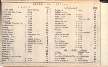
Administrative record - Tram fare route diagrams or maps, Melbourne & Metropolitan Tramways Board (MMTB), 1930s
... The route maps give for each tram, including cable trams, and bus routes, a map of the fare structure, sections, all-night routes, details of transfers and tickets such as combined tickets. ...Melbourne Tram Museum 8 Wallen Road Hawthorn melbourne The route maps give for each tram, including cable trams, and bus routes, a map of the fare structure, sections, all-night routes, details of transfers and tickets such as combined tickets. ...The route maps give for each tram, including cable trams, and bus routes, a map of the fare structure, sections, all-night routes, details of transfers and tickets such as combined tickets. Not dated as such but sheet 1 has a note regarding the East Brighton - St Kilda route that it was out of date from 16/10/1938.Yields information about the MMTB fare structure for tram, and bus routes during the 1930s.Album brown card heavy card coves, secured with two interscrews containing a type index, 33 cartridge paper sheets with ink drawings and six loose sheets. Hand drawn in black, red and green ink.mmtb, tramways, fares, maps, routes, buses, cable trams -
 Melbourne Tram Museum
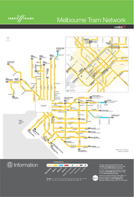
Poster, Metlink, "Melbourne tram network", Jul. 2005
... Digital Image of the July 2005 version of the tram and route map for Melbourne titled "Melbourne tram network". ...Melbourne Tram Museum 8 Wallen Road Hawthorn melbourne Trams tramways Maps Metlink Melbourne Routes Digital Image of the July 2005 version of the tram and route map for Melbourne titled "Melbourne tram network". ...Digital Image of the July 2005 version of the tram and route map for Melbourne titled "Melbourne tram network". Published by Metlink. Shows each of the route, terminal points, with a legend. Has Yarra Trams, Metcard and Metlink logos.trams, tramways, maps, metlink, melbourne, routes -
 Melbourne Tram Museum
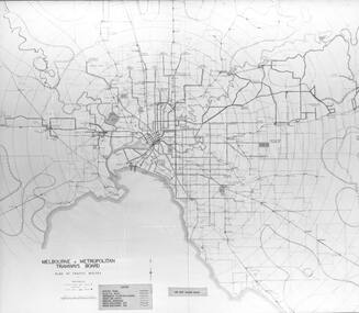
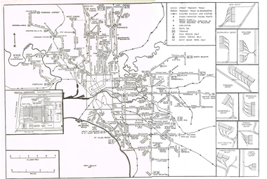
Map, Track plan or track map or layout of the Melbourne system, c1973
... Route Numbers... Terminus... Map...Track plan or track map or layout of the Melbourne system showing track layout, crossovers, depots, workshops and route numbers, terminus, substations, Bundy clocks, layout of Preston works. ...Melbourne Tram Museum 8 Wallen Road Hawthorn melbourne Trams tramways MMTB Track Layout Junction Depots Substation Plans Trackwork Route Numbers Terminus Map Bundy clock Track plan or track map or layout of the Melbourne system showing track layout, crossovers, depots, workshops and route numbers, terminus, substations, Bundy clocks, layout of Preston works. ...Track plan or track map or layout of the Melbourne system showing track layout, crossovers, depots, workshops and route numbers, terminus, substations, Bundy clocks, layout of Preston works. On the rear is a detailed layout of the city area. Shows railway stations but not the station names and rivers. Printed on cartridge paper. No details of to who prepared the plan or the drawing or date. Wattle Park line has been duplicated (Sept 1970), but the Essendon Airport line remains (closed Oct. 1976).trams, tramways, mmtb, track layout, junction, depots, substation, plans, trackwork, route numbers, terminus, map, bundy clock -
 Bendigo Historical Society Inc.
Document - J W SWATTON COLLECTION: RACV ROUTE MAPS
... Four RACV Route Maps and Touring Information, Bendigo to Alexandra via Seymour and Yea, Bendigo to Mt Gambier and return, Bendigo to Horsham via Ararat and Bendigo to Anglesea, dated 1 March 76. ...Document J W SWATTON COLLECTION: RACV ROUTE MAPS ...Four RACV Route Maps and Touring Information, Bendigo to Alexandra via Seymour and Yea, Bendigo to Mt Gambier and return, Bendigo to Horsham via Ararat and Bendigo to Anglesea, dated 1 March 76. Also an unsigned Safe Driving Pledge.j w swatton collection, royal automobile club of victoria -
 Melbourne Tram Museum
Ephemera - Timetable, Melbourne & Metropolitan Tramways Board (MMTB), Set of 14 MMTB Bus timetables, Jul. 1969
... Set of 14 MMTB Bus timetables, folded sheets, providing timetables for specific routes, day of week giving information on tram times at specific time points, route map, sections and fares and organisation address - 616 Little Collins St. ...Yields information about MMTB Bus services July 1969 Trams tramways Timetables Tickets Bus Services Fares MMTB Set of 14 MMTB Bus timetables, folded sheets, providing timetables for specific routes, day of week giving information on tram times at specific time points, route map, sections and fares and organisation address - 616 Little Collins St. ...All July 1969 - no route numbers shown. .1 - Box Hill - Heidelberg - Templestowe .2 - East Kew - Box Hill - Doncaster .3 - Deer Park - Sunshine Park - Sunshine - Footscray - City .4 - Fishermen's Bend - City .5 - Williamstown Rd - Footscray Railway Stn - Ballarat Rd .6 - Garden City - City .7 - La Trobe University - Northland - West Heidelberg - City .8 - Box Hill - North Blackburn .9 - Bulleen - North Kew - City .10 - Clifton Hill - Elsternwick .11 - Box Hill - East Doncaster - Mitcham - Ringwood .12 - Deer Park - Sunshine Park - Sunshine - Footscray - City - Saturdays and Sundays - printed on pink paper. 13 - Warrandyte - Donvale Post Office - City 14 - Warrandyte - Park Orchards, Ringwood.Yields information about MMTB Bus services July 1969Set of 14 MMTB Bus timetables, folded sheets, providing timetables for specific routes, day of week giving information on tram times at specific time points, route map, sections and fares and organisation address - 616 Little Collins St. Melbourne.trams, tramways, timetables, tickets, bus services, fares, mmtb -
 Bendigo Historical Society Inc.
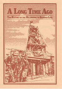
Document - ''A LONG TIME AGO'': THE HISTORY OF THE MELBOURNE TO BENDIGO LINE
... V/Line publication (fold-out) with brief history of construction and simplified route map of line with brief description of some of the railway line features as well as information about towns and special features on the route....V/Line publication (fold-out) with brief history of construction and simplified route map of line with brief description of some of the railway line features as well as information about towns and special features on the route. ...''A Long Time Ago'' - The history of the Melbourne to Bendigo line. V/Line publication (fold-out) with brief history of construction and simplified route map of line with brief description of some of the railway line features as well as information about towns and special features on the route.V/Line Publication, Walker Printing Bendigo.bendigo, history, bendigo railway, bendigo railway, stations on the bendigo line -
 Melbourne Tram Museum
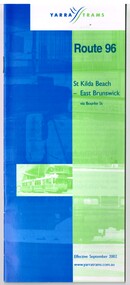
Ephemera - Timetable, Yarra Trams, "Route 96 - St Kilda Beach - East Brunswick", Sep. 2002
... Provide details about Yarra Trams, Metcards, route map, timing points and route description....Provide details about Yarra Trams, Metcards, route map, timing points and route description. ...Printed 24 page book, blue green cover stapled timetable for "Route 96 - St Kilda Beach - East Brunswick" tram service, dated September 2002. Provide details about Yarra Trams, Metcards, route map, timing points and route description.trams, tramways, tickets, yarra trams, tram services, timetables, route 96