Showing 21 items matching "rowsley"
-
 Bacchus Marsh & District Historical Society
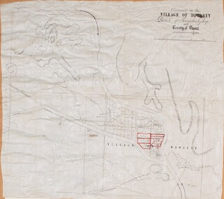
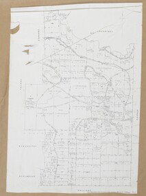
Map, Allotments in the Village of Rowsley, Parish of Gorrocburkghap, County of Grant c.1856
... Allotments in the Village of Rowsley, Parish of Gorrocburkghap, County of Grant c.1856...Rowsley is a locality 11 kilometers south-west of Bacchus Marsh. ...A cadastral map of the Village of Rowsley in Victoria, showing numbered land allotments. 57 allotments are shown on the map and some areas set aside as reserves. ...MAPS 820 BJE 1837- ROWSLEY 1856. Rowsley Victoria History Rowsley Victoria Maps A single page paper map. ...Rowsley is a locality 11 kilometers south-west of Bacchus Marsh. The date of this map is uncertain. A very similar map held by the State Library of Victoria (SLV) contains slightly more information than this copy and is dated as an 1856 map. SLV reference: 'Allotments in the Village of Rowsley, Parish of Gorrocburkghap, County of Grant', by T. Nixon, Assistant Surveyor, May 1856 ; Surveyor General’s Office, July 18 1856 (lithographed by R. Meikle). (1856). Melbourne: Surveyor General’s Office. MAPS 820 BJE 1837- ROWSLEY 1856. A single page paper map. A cadastral map of the Village of Rowsley in Victoria, showing numbered land allotments. 57 allotments are shown on the map and some areas set aside as reserves. Allotments 8, and 10-16 are outlined in red ink and allotment 9 has a cross in red ink on it. The map is pasted into a bound volume containing 76 maps or plans in total. High resolution digital image stored on BMDHS computer network. rowsley victoria history, rowsley victoria maps -
 Bacchus Marsh & District Historical Society
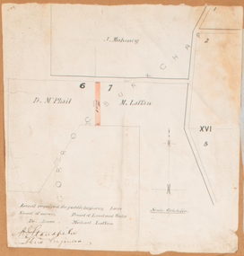
Map, Land required for a public highway near Rowsley, Victoria. Circa 1880s
... Land required for a public highway near Rowsley, Victoria. Circa 1880s....This map indicates portions of land in the Parish of Gorrockburkchap near Rowsley which was required for construction of a road. ...Rowsley Victoria Maps Signed by Shire Engineer, W.E. ...This map indicates portions of land in the Parish of Gorrockburkchap near Rowsley which was required for construction of a road. The land required was leased to a Michael Laffan. Other blocks of land nearby owned or leased by D. McPhail and J. Mahoney are also indicated on the map. The date of the map is not known. However newspaper reports in the Bacchus Marsh Express on the 18 March 1882, page 3, column 3 mention land occupied by McPhail and Laffan near Rowsley in connection to the construction of a public road.Single page map showing land occupied by farmers D. McPhail and Michael Laffan which was required for a public highway. Scale 6 chains to inch. Part of a set of maps which are pasted into a bound volume containing 76 maps or plans in total. High resolution digital image stored on BMDHS computer network. Signed by Shire Engineer, W.E. Standfieldrowsley victoria maps -
 Bacchus Marsh & District Historical Society
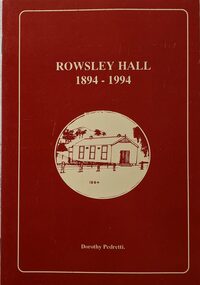
Booklet, Rowsley Hall 1894-1994
... Rowsley Hall 1894-1994...Bacchus Marsh & District Historical Society Lerderderg Library Main Street Bacchus Marsh Rowsley Victoria History Halls Rowsley Hall Rowsley is a rural locality 6km south-west of Bacchus Marsh. ...Rowsley is a rural locality 6km south-west of Bacchus Marsh. It is a very small community and the Rowsley Hall has been a community meeting place for over 100 years. This history tells the story of the origin of the Hall and its place in the community's history for its first 100 years. Citation: Rowsley Hall, 1894-1994, by Dorothy Pedretti. Published by Bacchus Marsh and District Historical Society, Bacchus Marsh, Vic., 1995?A small booklet. 36 unnumbered pages. Stapled binding. Contains black and white photographs, maps and facsimiles of documents. BMDHS Loc: AR/SU5/Pamphlets Box 4Rowsley is a rural locality 6km south-west of Bacchus Marsh. It is a very small community and the Rowsley Hall has been a community meeting place for over 100 years. This history tells the story of the origin of the Hall and its place in the community's history for its first 100 years. Citation: Rowsley Hall, 1894-1994, by Dorothy Pedretti. Published by Bacchus Marsh and District Historical Society, Bacchus Marsh, Vic., 1995?rowsley victoria history, halls, rowsley hall -
 Bacchus Marsh & District Historical Society
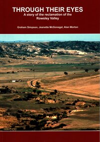
Book, Through Their Eyes : A Story of the Reclamation of the Rowsley Valley
... Through Their Eyes : A Story of the Reclamation of the Rowsley Valley...Through Their Eyes : A Story of the Reclamation of the Rowsley Valley Book ...This book contains a collection of articles written by landholders, local residents and members of corporate and volunteer organisations describing their roles in the restoration of Rowsley Valley. The historical scope of this book encompasses the geological and environmental history of the area prior to human habitation, occupation by the Wadawurrung people prior to European colonisation, and the colonial and post colonial eras. This introductory contextual background is complemented by the rest of the book which describes the various aspects of the environmental restoration of the Rowsley Valley from the latter part of the 20th century continuing to the present day.Printed foolscap size book. Softcover. 112 pages. Colour and black and white photos. Maps, figures, tables. Index. Publication details. Graham Simpson (Publisher, Bacchus Marsh, Victoria, 2021. Lead authors Graham Simpson, Jeanette McGonegal and Alan Morton.This book contains a collection of articles written by landholders, local residents and members of corporate and volunteer organisations describing their roles in the restoration of Rowsley Valley. The historical scope of this book encompasses the geological and environmental history of the area prior to human habitation, occupation by the Wadawurrung people prior to European colonisation, and the colonial and post colonial eras. This introductory contextual background is complemented by the rest of the book which describes the various aspects of the environmental restoration of the Rowsley Valley from the latter part of the 20th century continuing to the present day.environmental restoration projects, rowsley valley victoria environmental history, conservation of natural resources, aboriginal australians bacchus marsh region history, wadawurrung people history -
 Flagstaff Hill Maritime Museum and Village
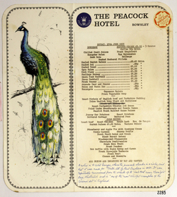
Menu
... ...Rowsley...Menu from The Peacock Hotel, Rowsley, England....Flagstaff Hill Maritime Museum and Village 89 Merri Street Warrnambool great-ocean-road flagstaff hill warrnambool shipwrecked-coast flagstaff-hill flagstaff-hill-maritime-museum maritime-museum shipwreck-coast flagstaff-hill-maritime-village Menu The Peacock Hotel Rowsley Menu from The Peacock Hotel, Rowsley, England. ...Menu from The Peacock Hotel, Rowsley, England.flagstaff hill, warrnambool, shipwrecked-coast, flagstaff-hill, flagstaff-hill-maritime-museum, maritime-museum, shipwreck-coast, flagstaff-hill-maritime-village, menu, the peacock hotel, rowsley -
 Ballarat Heritage Services
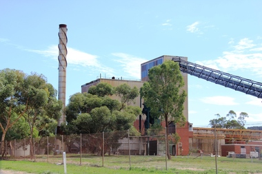
Digital photographs, L.J. Gervasoni, Boiler House CSR Timbrock Factory Maddingley Prior to Demolition, 2012, 2012
... 25 Rowsley Station Road, Maddingley, Hepburn Shire, Victoria, Australia...Ballarat Heritage Services PO Box 2209 Bakery Hill Post Office goldfields http://vhd.heritagecouncil.vic.gov.au/places/69285 jbd timbrock rowsley station maddingley factory csr jack mcconnell heritage boiler house industry industrial Digital images of the csr Boiler House Timbrock Factory at Maddingley prior to demolition. ...http://vhd.heritagecouncil.vic.gov.au/places/69285 Digital images of the csr Boiler House Timbrock Factory at Maddingley prior to demolition.jbd, timbrock, rowsley station, maddingley, factory, csr, jack mcconnell, heritage, boiler, house, industry, industrial -
 Ballarat Heritage Services
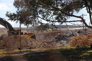
Photograph - Digital photographs, L.J. Gervasoni, Boiler House CSR Timbrock Factory Maddingley post demolition, 2016
... 25 Rowsley Station Road, Maddingley, Hepburn Shire, Victoria, Australia...Ballarat Heritage Services PO Box 2209 Bakery Hill Post Office goldfields http://vhd.heritagecouncil.vic.gov.au/places/69285 jbd timbrock rowsley station maddingley factory csr jack mcconnell heritage boiler house industry industrial demolition Boiler House CSR Timbrock Factory Maddingley post demolition Boiler House CSR Timbrock Factory Maddingley post demolition Photograph Digital photographs L.J. ...http://vhd.heritagecouncil.vic.gov.au/places/69285 Boiler House CSR Timbrock Factory Maddingley post demolitionjbd, timbrock, rowsley station, maddingley, factory, csr, jack mcconnell, heritage, boiler, house, industry, industrial, demolition -
 Ballarat Heritage Services
Digital photographs, L.J. Gervasoni, CSR Timbrock Factory Maddingley - Jack McConnell Architect, 2015
... 25 Rowsley Station Road, Maddingley, Hepburn Shire, Victoria, Australia...Ballarat Heritage Services PO Box 2209 Bakery Hill Post Office goldfields http://vhd.heritagecouncil.vic.gov.au/places/69285 jbd timbrock rowsley station maddingley factory csr jack mcconnell heritage industry industrial glass curtain wall modern Digital images CSR Timbrock Factory Maddingley - Jack McConnell Architect Digital photographs L.J. ...http://vhd.heritagecouncil.vic.gov.au/places/69285 Digital imagesjbd, timbrock, rowsley station, maddingley, factory, csr, jack mcconnell, heritage, industry, industrial, glass, curtain, wall, modern -
 Ballarat Heritage Services
Photograph - Digital photographs, L.J. Gervasoni, CSR Timbrock Factory Maddingley - internal remains of boiler, 2015
... 25 Rowsley Station Road, Maddingley, Hepburn Shire, Victoria, Australia...Ballarat Heritage Services PO Box 2209 Bakery Hill Post Office goldfields http://vhd.heritagecouncil.vic.gov.au/places/69285 jbd timbrock rowsley station maddingley factory csr jack mcconnell heritage industry industrial machinery CSR Timbrock Factory Maddingley - internal remains of boiler CSR Timbrock Factory Maddingley - internal remains of boiler Photograph Digital photographs L.J. ...http://vhd.heritagecouncil.vic.gov.au/places/69285 CSR Timbrock Factory Maddingley - internal remains of boilerjbd, timbrock, rowsley station, maddingley, factory, csr, jack mcconnell, heritage, industry, industrial, machinery -
 Bacchus Marsh & District Historical Society
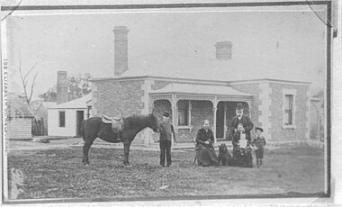
Photograph, Rutherford family Bacchus Marsh district 1883
... It was located near the Bacchus Marsh Racecourse heading towards Rowsley. It was also described as being near the Rowsley Station which was a small railway station a few kilometres south-west of Bacchus Marsh. ...It was located near the Bacchus Marsh Racecourse heading towards Rowsley. It was also described as being near the Rowsley Station which was a small railway station a few kilometres south-west of Bacchus Marsh. ...This image shows the Rutherford family at their property near Bacchus Marsh. The bearded man to the right of the picture is probably Thomas Rutherford. The other people in the picture are probably members of his family. The Rutherford property was a dairy farm and was at one stage described as a 'model farm' by the Bacchus Marsh Express newspaper. It was located near the Bacchus Marsh Racecourse heading towards Rowsley. It was also described as being near the Rowsley Station which was a small railway station a few kilometres south-west of Bacchus Marsh. The Rowsley Station existed from 1889 until replaced by a railway siding in 1959. The Melbourne photographers Stevenson & McNicoll visited the Bacchus Marsh district in 1883. They took photographs of many local families and individuals in front of their houses or businesses. More than 50 of these images were preserved by the Hawkins family of Bacchus Marsh and passed to a granddaughter of that family Mrs Beryl Jeremeas who donated those images to the Bacchus Marsh and District Historical Society in 1973. Stevenson & McNicoll are known to have taken numerous studio portrait photographs of Bacchus Marsh people. This was probably the larger part of their work. However very few of these images have been acquired by local historical societies. A black and white photographic copy of sepia coloured Carte de Visite photograph on cardboard. The photo is of a family group standing and sitting in front of a substantial brick farmhouse. A plainer dwelling stands at the back of the farm house and is probably the day-to-day utility house. The group consists of a well-dressed gentleman, probably Mr Thomas Rutherford, two women and three children, a baby, a young girl and an older boy holding a saddled pony. The family's dog is included in the photo. On the front: Stevenson and McNicoll. Photo. 108 Elizabeth St, Melbourne. Copies can be obtained at any time. On the Back: Logo of the rising sun with the words LIGHT & TRUTH on a banner. Copies of this portrait can be had at any time by sending the Name and Post Office Money Order or Stamps for the amount of order to Stevenson & McNicoll Late Benson & Stevenson, Photographers. 108 Elizabeth Street, Melbourne. stevenson and mcnicoll 1883 photographs of bacchus marsh and district, stevenson and mcnicoll photographers, rutherford family bacchus marsh district -
 Bacchus Marsh & District Historical Society
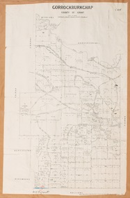
Map, Gorrockburkchap Parish Map, County of Grant
... The parish of Gorrockburkchap (sometimes spelled Gorrockburkghap) lies to the west and south west of the township of Bacchus Marsh. The locality of Rowsley is situated within this parish area....Gorrockburkchap Parish Maps Rowsley Victoria Maps A single page paper map showing the parish plan for Gorrockburkchap in the County of Grant. ...The parish of Gorrockburkchap (sometimes spelled Gorrockburkghap) lies to the west and south west of the township of Bacchus Marsh. The locality of Rowsley is situated within this parish area.A single page paper map showing the parish plan for Gorrockburkchap in the County of Grant. The map is pasted into a bound volume containing 76 maps or plans in total. High resolution digital image stored on BMDHS computer network. gorrockburkchap parish maps, rowsley victoria maps -
 Bacchus Marsh & District Historical Society
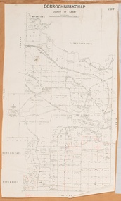
Map, Gorrockburkchap Parish Map, County of Grant c.1915
... The parish of Gorrockburkchap (sometimes spelled Gorrockburkghap) lies to the west and south west of the township of Bacchus Marsh. The locality of Rowsley is situated within this parish area....Gorrockburkchap Parish Maps Rowsley Victoria Maps A single page paper map showing the parish plan for Gorrockburkchap in the County of Grant. ...The parish of Gorrockburkchap (sometimes spelled Gorrockburkghap) lies to the west and south west of the township of Bacchus Marsh. The locality of Rowsley is situated within this parish area.A single page paper map showing the parish plan for Gorrockburkchap in the County of Grant. The map is pasted into a bound volume containing 76 maps or plans in total. High resolution digital image stored on BMDHS computer network. gorrockburkchap parish maps, rowsley victoria maps -
 Bacchus Marsh & District Historical Society
Map, Gorrockburkchap Parish Map, County of Grant c.1906
... The parish of Gorrockburkchap (sometimes spelled Gorrockburkghap) lies to the west and south west of the township of Bacchus Marsh. The locality of Rowsley is situated within this parish area....Gorrockburkchap Parish Maps Rowsley Victoria Maps Bacchus Marsh Region Parish Plans A single page paper map showing the parish plan for Gorrockburkchap in the County of Grant. ...The parish of Gorrockburkchap (sometimes spelled Gorrockburkghap) lies to the west and south west of the township of Bacchus Marsh. The locality of Rowsley is situated within this parish area.A single page paper map showing the parish plan for Gorrockburkchap in the County of Grant. A cadastral map showing parish boundaries and land ownership The map is pasted into a bound volume containing 76 maps or plans in total. High resolution digital image stored on BMDHS computer network. gorrockburkchap parish maps, rowsley victoria maps, bacchus marsh region parish plans -
 Bacchus Marsh & District Historical Society
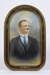
Painting, Portrait of Thomas Manly, 1930
... Deceased was a great walker, and mostly walked to his work, both at Rowsley and for the past 27 years to the Darley brickworks. ...Deceased was a great walker, and mostly walked to his work, both at Rowsley and for the past 27 years to the Darley brickworks. ...Thomas Manly was a well-known resident of Bacchus Marsh. Born at Rowsley in 1863, Mr. Manly was a grandson in a family who had been in the service of the Greene family at "Greystones" from the time of its arrival in Victoria. The woolsheds at "Greystones" were built by deceased's grandfather, who also conducted a jeweller's shop at Rowsley. Like his forebears, Mr. Thomas Manly entered the service at "Greystones" and later worked for Messrs. Chomley and Boyd at "Glenmore." After his marriage to Miss Mary Johnston, whose mother arrived as an infant in Bacchus Marsh as early as 1839, Mr. Manly took up residence in the Main Street, Bacchus Marsh, where he has lived ever since. Deceased was a great walker, and mostly walked to his work, both at Rowsley and for the past 27 years to the Darley brickworks. Never a prominent man in public affairs, he was essentially a home-lover, and adopted horticulture as his hobby, gaining many prizes for both flowers and lucerne. Text for this description taken from the obituary for Thomas Manly in the Bacchus Marsh Express, 26 June, 1937, page 3, column 2.A framed painting based on a 1930 photograph of Tom Manly.'Heirloom' inscribed at the bottom right hand corner of the paintingthomas manly 1863-1937, bacchus marsh and district biographies -
 Federation University Historical Collection
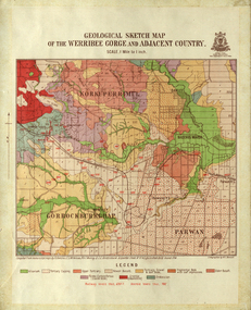
Map, Geological Sketch Map of the Werribee Gorge and Adjacent Country, 1914, 1914
... ...rowsley...Barker Library (top floor) Mount Helen goldfields werribee gorge bacchus marsh darley parwan w.e. bennett bennett r.a.f. murray c.c. brittlebank rowsley A coloured geological sketch map of the Werribee Gorge, Bacchus Marsh, Rowlesy, Darley, Parwan. ...A coloured geological sketch map of the Werribee Gorge, Bacchus Marsh, Rowlesy, Darley, Parwan. The scale is 1 mile to 1 inchwerribee gorge, bacchus marsh, darley, parwan, w.e. bennett, bennett, r.a.f. murray, c.c. brittlebank, rowsley -
 Federation University Historical Collection
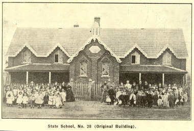
Booklet, Back to Bacchus Marsh, 1930, 1930
... ...rowsley...Contents include Bacchus Marsh and its soldiers, Red Cross, Lerderderg Gorge, Werribee Gorge, Lerderderg Park, Coimadai, Darely Firebrick Co., Myrniong, Underbank, Balliang, Rowsley, Parwan, schoosl, churches, Shire Council, Federal Milk Pty Ltd, Bacchus Marsh Milk, Old Maddingley Bridge Images include: * Bacchus Marsh looking east, 1930 * Bacchus Marsh Looking West, 1872 * Bacchus Marsh Looking West, 1930 * Aerial View of Bacchus Marsh Township looking east * Aerial View of Bacchus Marsh Township looking south * Bacchus Marsh Agricultural Society & Pastoral Society, 1893 (named), * Original Bacchus Marsh State School No 28 * Holy Trinity Bacchus Marsh * Bacchus Marsh Baptist Church * St Bernard's Catholic Church * Bacchus Marsh Methodist Church * St Andrew's Presbyterian Church Bacchus Marsh * View of Maddingley Park, showing Original Courthouse, 1890 * Werribee Gorge * Underbank Stud Farm * Ballarat State School Number 28. ...(Back to Bacchus Marsh, 1930) bacchus marsh maddingley maddingley park underbank lerderderg park coimadai darely firebrick co. myrniong balliang rowsley parwan schoosl churches shire council federal milk pty ltd bacchus marsh milk old maddingley bridge police police paddock maddingley gates crisp mccormack cain harkness howe bence mcdonald mcfarlane cosgrave flagg burnip scott lodge cameron vallance bacchus marsh state school bacchus marsh state school no 28. geology r.w. thompson lederderg gorge weribee gorge comadai darley firebrick company Signed 'C. ...The 1930 Back to Bacchus Marsh celebrations were held on 23 to 28 October 1930. The committee were Cr L.M. Gugdale (president), A.W. Bond (General secretary), W. Grant Morton, J.G. Wells, Dr E. McDonald, Charles Dickie, G.H. Anderson, F.M. Crisp, W.R. Vigor. Bacchus Marsh State School No. 28 was established in 1851 as a National School in a rented building on the right-hand side of Bacchus Marsh-Melbourne Road, just beyond Woolpack Inn. Several willow trees mark the site. H.G. Ball was the first Head Teacher of the school, and the enrolmen towas 34. In 1854 Governor Charles Hotham visited the school. In 1855 two new schools, East and West, were recommended. School No. 28 closed in 1862 and the sitre was sold. The present school site was purchased in 1865 for 67 pounds. The cost of the building was 782 pounds. (Visions and Realisations, Vol 3., 1973) A clock purchased by public subscription was placed in the front of the building to the memory of scholars who served during World War One. (Back to Bacchus Marsh, 1930)Brown covered book of 44 pages. Contents include Bacchus Marsh and its soldiers, Red Cross, Lerderderg Gorge, Werribee Gorge, Lerderderg Park, Coimadai, Darely Firebrick Co., Myrniong, Underbank, Balliang, Rowsley, Parwan, schoosl, churches, Shire Council, Federal Milk Pty Ltd, Bacchus Marsh Milk, Old Maddingley Bridge Images include: * Bacchus Marsh looking east, 1930 * Bacchus Marsh Looking West, 1872 * Bacchus Marsh Looking West, 1930 * Aerial View of Bacchus Marsh Township looking east * Aerial View of Bacchus Marsh Township looking south * Bacchus Marsh Agricultural Society & Pastoral Society, 1893 (named), * Original Bacchus Marsh State School No 28 * Holy Trinity Bacchus Marsh * Bacchus Marsh Baptist Church * St Bernard's Catholic Church * Bacchus Marsh Methodist Church * St Andrew's Presbyterian Church Bacchus Marsh * View of Maddingley Park, showing Original Courthouse, 1890 * Werribee Gorge * Underbank Stud Farm * Ballarat State School Number 28. Signed 'C. Hodgson'bacchus marsh, maddingley, maddingley park, underbank, lerderderg park, coimadai, darely firebrick co., myrniong, balliang, rowsley, parwan, schoosl, churches, shire council, federal milk pty ltd, bacchus marsh milk, old maddingley bridge, police, police paddock, maddingley gates, crisp, mccormack, cain, harkness, howe, bence, mcdonald, mcfarlane, cosgrave, flagg, burnip, scott, lodge, cameron, vallance, bacchus marsh state school, bacchus marsh state school no 28., geology, r.w. thompson, lederderg gorge, weribee gorge, comadai, darley firebrick company -
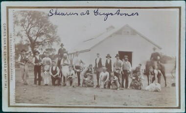 Bacchus Marsh & District Historical Society
Photograph, Shearers and Overseers at Greystones Station 1883
... The photo shows a group of sixteen men standing or kneeling outside a large shearing shed at Greystones, Rowsley. Behind them are two mounted men, probably overseers or managers. ...The photo shows a group of sixteen men standing or kneeling outside a large shearing shed at Greystones, Rowsley. Behind them are two mounted men, probably overseers or managers. ...Greystones station was originally part of the Glenmore run, established in 1840 by Charles Griffith. Originally a run of 55,00 acres, Glenmore was subdivided in the 1870s to form the Greystones property, owned and managed by Molesworth Greene, the nephew of Charles Griffith. The property had 11,000 sheep and was renowned for its high quality wool. In November 2023, the property of 4033 hectares was sold to overseas investors. The wool industry was a major industry in the development of the Australian economy from pre-colonial times. It gave rise to the saying that Australia 'rode on the sheep's back.'Small black and white 'carte de visite' style unframed photograph on card with gold border framing photograph. One of a set of photographs of Bacchus Marsh and District taken in 1883 by the photographers Stevenson and McNicoll. The photo shows a group of sixteen men standing or kneeling outside a large shearing shed at Greystones, Rowsley. Behind them are two mounted men, probably overseers or managers. The standing group includes a man with a fiddle and one with a concertina. The cook, wearing a white apron and hat can also be identified. Six men have hand-held shears, three in poses of shearing a sheep. Printed On the front: Stevenson & McNicoll. Photo. 108 Elizabeth St. Melbourne. COPIES CAN BE OBTAINED AT ANY TIME. On the back: LIGHT & TRUTH inscribed on a banner surmounted by a representation of the rising sun. Copies of this Portrait can be had at any time by sending the Name and Post Office Money Order or Stamps for the amount of order to STEVENSON & McNICOLL LATE BENSON & STEVENSON, Photographers. 108 Elizabeth Street, MELBOURNE. Handwritten in biro along the top: Shearers at Greystones. stevenson and mcnicoll 1883 photographs of bacchus marsh and district, shearers, greystones estate bacchus marsh, glenmore run, wool industry, charles james griffith 1808-1863, molesworth r. green 1827-1916 -
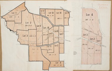 Bacchus Marsh & District Historical Society
Map, Glenvale Estate and Glenmore Estate Land Sales 1909
... Griffith and James Moore which the began in the Rowsley area south west of Bacchus Marsh in the 1840s. ...Griffith and James Moore which the began in the Rowsley area south west of Bacchus Marsh in the 1840s. ...The two land auction plans shown in this record relate to the sale of land from the Glenmore Estate property. The Glenmore property was established by C.J. (Charles James) Griffith and James Moore around 1840. Moore sold his interest to Moelesworth Greene in 1848. Greene was the nephew of the other owner Charles Griffith who died in 1863. From around the 1870s onwards parts of the Estate were subdivided and put up for sale or lease. In subsequent decades more changes in ownership occurred. These two plans document another major sale of the land from the original Glenmore Estate including part of the estate which had become used for dairy farming and was at that time known as the Glenvale Estate. Two single page maps pasted together on a single page of a bound volume of maps. One map shows 15 separate lots of land for sale. The other map which has the words 'Glenvale Estate' at the top of the map shows 4 lots of land for sale. Both parcels of land were originally part of the Glenmore Estate a pastoral holding belonging to C.J. Griffith and James Moore which the began in the Rowsley area south west of Bacchus Marsh in the 1840s. The maps are pasted into a bound volume containing 76 maps or plans in total. High resolution digital image stored on BMDHS computer network. bacchus marsh victoria maps, glenvale estate property, glenvale estate land sales, glenmore estate, glenmore station -
 Bacchus Marsh & District Historical Society
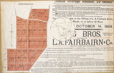
Map, Greystones Estate Land Sale 1909
... And situated only six miles from that prosperous township, two miles from Rowsley, and three miles from Parwan, all Railway towns, connected with the Estate by metal roads." ...Green 1827-1916 Land Sales Rowsley A single page paper map showing portions of land for sale from the Greystones Estate near Bacchus Marsh. ...This map was produced sometime around mid 1909 to advertise portions of land from the Greystones Estate for sale by public tender. The selling agents were Young Brothers of Horsham and L.A. Fairbairn of Bacchus Marsh and Melbourne. The seller was Molesworth R. Greene who was a pioneer pastoralist in the Bacchus Marsh area and had also acquired other properties in Victoria and interstate. Molesworth Greene died in 1916 so this sale came towards the end of his life. A total of 4,176 acres was offered for sale in multiple lots. Successful tenderers could buy single or multiple lots. The results of the sale were reported in the Bacchus Marsh Express newspaper on the 16th October 1909, page 3. At the sale a total of 3, 420 acres was sold. A single page paper map showing portions of land for sale from the Greystones Estate near Bacchus Marsh. The map includes extensive details about the property, number of allotments for sale, terms and conditions of the sale and prices. The map includes an inserted reference map showing the location of the property in relation to Melbourne, Geelong, Ballarat and Castlemaine. The top of the map appears to be missing resulting in some loss of the text. The sale notice in the Bacchus Marsh Express of 10 July, 1909, page 3, column 1 appears to duplicate the text overall in the auction plan. Based on this the missing text is likely to be: "Important Subdivisional Sale 'Of Portion of One of the Best and Most Favourably known Estates IN THE RENOWNED BACCHUS MARSH DISTRICT. And situated only six miles from that prosperous township, two miles from Rowsley, and three miles from Parwan, all Railway towns, connected with the Estate by metal roads." Scale: 20 chains to 1 inch The map is pasted into a bound volume containing 76 maps or plans in total. bacchus marsh victoria maps, land sales, land sales bacchus marsh, greystones estate bacchus marsh, molesworth r. green 1827-1916, land sales rowsley -
 Federation University Historical Collection
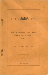
Booklet, Thomas Stephen Hart, The Highlands and Main Divide of Western Victoria, 1907, 12/12/1907
... Diagram to illustrate the possible courses of the leads south of the present Divide - Burrumbeet Basin (Smythesdale, Ballarat, Lal Lal , Mt Doran, egerton, Parwan Creet, Rowsley Fault, Eastern Plateau) Fig. 6. Diagramatic cross section of the grampians, south of Hall's Gap. ...Diagram to illustrate the possible courses of the leads south of the present Divide - Burrumbeet Basin (Smythesdale, Ballarat, Lal Lal , Mt Doran, egerton, Parwan Creet, Rowsley Fault, Eastern Plateau) Fig. 6. Diagramatic cross section of the grampians, south of Hall's Gap. ...Thomas S. Hart was a teacher at the Ballarat School of Mines, and a member of the Ballarat Field Naturalists ClubArticle with illustrations published by the Royal Society of Victoria by Thomas S. Hart. The following plates are included: Fig 1. The Main Divide and some of the transverse ridges Fig 2. Hills on and near the Divide at the Ercildoun and Ascot Gaps Fig. 3. Profile of the Divide at Ascot Gap. Fig. 4. Sketch of the Hills west and north-west from Mt Buninyong - - The divide in Ascot Gap from Mt Blowhard (Serra Range, Mt William, Mt Ararat, Larne Gerin, Ben Major, Mt Cole, Mt Misery, Mt Bolton) Fig. 5. Diagram to illustrate the possible courses of the leads south of the present Divide - Burrumbeet Basin (Smythesdale, Ballarat, Lal Lal , Mt Doran, egerton, Parwan Creet, Rowsley Fault, Eastern Plateau) Fig. 6. Diagramatic cross section of the grampians, south of Hall's Gap. Profile of the Pyranees, from maiden Hill - Diagramatic Section of the Grampians south of Hall's Gap. (Mt Cole, Mt Mitchell, Ben Major, Ben More, Avoca Hill, Hall's Gap.) Fig. 7. Profile of the Pyrenees as seen from Maiden Hill near Waubra.thomas hart, thomas s. hart, ballarat school of mines, ballarat field naturalists club, royal society of victoria, western victoria, ballarat, great dividing range, mt william, volcano, volcanic plains, waterways, lal lal basin, yarrowee creek, ballarat common, lava flow, wendouree, warrenheip, ballarat plateau, mt elephant, grampians, t.s. hart, mt buangor, mt beckworth, mt misery, mt bolton, lal lal iron ored, mt ararat, mt wiliam, mt cole, burrumbeet, mt warrenheip, daylesford, waubra, ercildoun gap, smythesdale, lal lal falls, parwan valley, burrumbeet creek, staffordshire reef, pyranees, bacchus marsh, rowsley fault, ben nevis, avoca hill, landsborough hill, mt blowhard, weatherboard, mclean's hill, fyan's creek, thomas stephen hart, lal lal -
 Truganina Explosives Reserve Preservation Society Inc (TERPS)
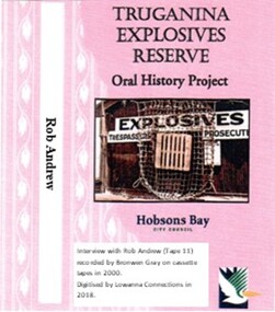
Digitised Oral History – Truganina Explosives Reserve - Tape 11 Rob Andrew, 2018
... A primary source of information on memories of the Truganina Explosives Reserve and Altona,Victoria Native grasses explosives Cheetham Wetlands Cheetham Salt Works Doug Grant Chirnside Cliff Gibson lava plain brown coal sand ridges Selwyn Fault Rowsley Fault Victorian Coastal Strategy aboriginal stone artefacts aboriginal habitation aboriginal remains red gums casuarinas Altona Skipper Butterfly Orange Bellied Parrot Digital copy of original cassette recorded in 2000 and digitised in 2018 Digitised Oral History – Truganina Explosives Reserve - Tape 11 Rob Andrew ...The interviews were recorded in 2000 by Bronwen Gray and Alan Young for the production of Unreserved, Stories from Truganina Explosives Reserve, animated stories from past residents, workers and interested people of the Reserve (subject to copyright 2004). Rob Andrew’s career was as an Environmental Health Officer with various councils around Victoria. As an Altona resident he became interested in the Truganina Explosives Reserve when he heard the site was to be sold. He was concerned that because of the prospect of commercial development the community would lose tranquil open parklands. Through his involvement with the Reserve he realised the historical, geomorphic, flora and fauna significance of the site. A primary source of information on memories of the Truganina Explosives Reserve and Altona,VictoriaDigital copy of original cassette recorded in 2000 and digitised in 2018native grasses, explosives, cheetham wetlands, cheetham salt works, doug grant, chirnside, cliff gibson, lava plain, brown coal, sand ridges, selwyn fault, rowsley fault, victorian coastal strategy, aboriginal stone artefacts, aboriginal habitation, aboriginal remains, red gums, casuarinas, altona skipper butterfly, orange bellied parrot