Showing 4 items matching "rowsley victoria history"
-
 Bacchus Marsh & District Historical Society
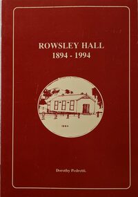
Booklet, Rowsley Hall 1894-1994
... Rowsley Victoria History...Bacchus Marsh & District Historical Society Lerderderg Library Main Street Bacchus Marsh Rowsley Victoria History Halls Rowsley Hall Rowsley is a rural locality 6km south-west of Bacchus Marsh. ...Rowsley is a rural locality 6km south-west of Bacchus Marsh. It is a very small community and the Rowsley Hall has been a community meeting place for over 100 years. This history tells the story of the origin of the Hall and its place in the community's history for its first 100 years. Citation: Rowsley Hall, 1894-1994, by Dorothy Pedretti. Published by Bacchus Marsh and District Historical Society, Bacchus Marsh, Vic., 1995?A small booklet. 36 unnumbered pages. Stapled binding. Contains black and white photographs, maps and facsimiles of documents. BMDHS Loc: AR/SU5/Pamphlets Box 4Rowsley is a rural locality 6km south-west of Bacchus Marsh. It is a very small community and the Rowsley Hall has been a community meeting place for over 100 years. This history tells the story of the origin of the Hall and its place in the community's history for its first 100 years. Citation: Rowsley Hall, 1894-1994, by Dorothy Pedretti. Published by Bacchus Marsh and District Historical Society, Bacchus Marsh, Vic., 1995?rowsley victoria history, halls, rowsley hall -
 Bacchus Marsh & District Historical Society
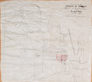
Map, Allotments in the Village of Rowsley, Parish of Gorrocburkghap, County of Grant c.1856
... Rowsley Victoria History...Rowsley is a locality 11 kilometers south-west of Bacchus Marsh. The date of this map is uncertain. A very similar map held by the State Library of Victoria (SLV) contains slightly more information than this copy and is dated as an 1856 map. SLV reference: 'Allotments in the Village of Rowsley, Parish of Gorrocburkghap, County of Grant', by T. Nixon, Assistant Surveyor, May 1856 ; Surveyor General’s Office, July 18 1856 (lithographed by R. Meikle). (1856). Melbourne: Surveyor General’s Office. MAPS 820 BJE 1837- ROWSLEY 1856. Rowsley Victoria History ...Rowsley is a locality 11 kilometers south-west of Bacchus Marsh. The date of this map is uncertain. A very similar map held by the State Library of Victoria (SLV) contains slightly more information than this copy and is dated as an 1856 map. SLV reference: 'Allotments in the Village of Rowsley, Parish of Gorrocburkghap, County of Grant', by T. Nixon, Assistant Surveyor, May 1856 ; Surveyor General’s Office, July 18 1856 (lithographed by R. Meikle). (1856). Melbourne: Surveyor General’s Office. MAPS 820 BJE 1837- ROWSLEY 1856. A single page paper map. A cadastral map of the Village of Rowsley in Victoria, showing numbered land allotments. 57 allotments are shown on the map and some areas set aside as reserves. Allotments 8, and 10-16 are outlined in red ink and allotment 9 has a cross in red ink on it. The map is pasted into a bound volume containing 76 maps or plans in total. High resolution digital image stored on BMDHS computer network. rowsley victoria history, rowsley victoria maps -
 Bacchus Marsh & District Historical Society
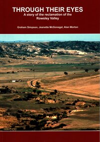
Book, Through Their Eyes : A Story of the Reclamation of the Rowsley Valley
... Rowsley Valley Victoria Environmental History...Bacchus Marsh & District Historical Society Lerderderg Library Main Street Bacchus Marsh Environmental Restoration Projects Rowsley Valley Victoria Environmental History Conservation of Natural Resources Aboriginal Australians Bacchus Marsh Region History Wadawurrung People History This book contains a collection of articles written by landholders, local residents and members of corporate and volunteer organisations describing their roles in the restoration of Rowsley Valley. ...This book contains a collection of articles written by landholders, local residents and members of corporate and volunteer organisations describing their roles in the restoration of Rowsley Valley. The historical scope of this book encompasses the geological and environmental history of the area prior to human habitation, occupation by the Wadawurrung people prior to European colonisation, and the colonial and post colonial eras. This introductory contextual background is complemented by the rest of the book which describes the various aspects of the environmental restoration of the Rowsley Valley from the latter part of the 20th century continuing to the present day.Printed foolscap size book. Softcover. 112 pages. Colour and black and white photos. Maps, figures, tables. Index. Publication details. Graham Simpson (Publisher, Bacchus Marsh, Victoria, 2021. Lead authors Graham Simpson, Jeanette McGonegal and Alan Morton.This book contains a collection of articles written by landholders, local residents and members of corporate and volunteer organisations describing their roles in the restoration of Rowsley Valley. The historical scope of this book encompasses the geological and environmental history of the area prior to human habitation, occupation by the Wadawurrung people prior to European colonisation, and the colonial and post colonial eras. This introductory contextual background is complemented by the rest of the book which describes the various aspects of the environmental restoration of the Rowsley Valley from the latter part of the 20th century continuing to the present day.environmental restoration projects, rowsley valley victoria environmental history, conservation of natural resources, aboriginal australians bacchus marsh region history, wadawurrung people history -
 Truganina Explosives Reserve Preservation Society Inc (TERPS)
Digitised Oral History – Truganina Explosives Reserve - Tape 11 Rob Andrew, 2018
... A primary source of information on memories of the Truganina Explosives Reserve and Altona,Victoria Native grasses explosives Cheetham Wetlands Cheetham Salt Works Doug Grant Chirnside Cliff Gibson lava plain brown coal sand ridges Selwyn Fault Rowsley Fault Victorian Coastal Strategy aboriginal stone artefacts aboriginal habitation aboriginal remains red gums casuarinas Altona Skipper Butterfly Orange Bellied Parrot Digital copy of original cassette recorded in 2000 and digitised in 2018 Digitised Oral History – Truganina Explosives Reserve - Tape 11 Rob Andrew ...The interviews were recorded in 2000 by Bronwen Gray and Alan Young for the production of Unreserved, Stories from Truganina Explosives Reserve, animated stories from past residents, workers and interested people of the Reserve (subject to copyright 2004). Rob Andrew’s career was as an Environmental Health Officer with various councils around Victoria. As an Altona resident he became interested in the Truganina Explosives Reserve when he heard the site was to be sold. He was concerned that because of the prospect of commercial development the community would lose tranquil open parklands. Through his involvement with the Reserve he realised the historical, geomorphic, flora and fauna significance of the site. A primary source of information on memories of the Truganina Explosives Reserve and Altona,VictoriaDigital copy of original cassette recorded in 2000 and digitised in 2018native grasses, explosives, cheetham wetlands, cheetham salt works, doug grant, chirnside, cliff gibson, lava plain, brown coal, sand ridges, selwyn fault, rowsley fault, victorian coastal strategy, aboriginal stone artefacts, aboriginal habitation, aboriginal remains, red gums, casuarinas, altona skipper butterfly, orange bellied parrot