Showing 18 items matching "rural school development"
-
 Kiewa Valley Historical Society
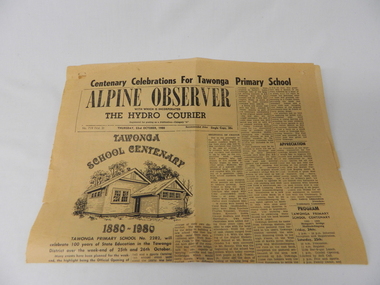
Newspaper Article - Tawonga School Centenary 1980 x2, Alpine Courier incorporating The Hydro Courier, 1980
... rural school development...The article also covers the changes brought about by the increased employment opportunities from SEC Kiewa Works(1935), the Sawmill(1946), the Gold mine(1949) and the Tobacco Industry (largest growing area in Australia). rural school development tawonga school centenary kiewa valley development 1880 to 1980 "Centenary Celebrations For Tawonga Primary School" below this in an enclosed heading "ALPINE OBSERVER" underneath in smaller print "WITH WHICH IS INCORPORATED" below this in larger print "THE HYDRO COURIER" and below this from left to right, "No. 719 (Vol. 3) THURSDAY, 23rd OCTOBER, 1980" next "in smaller print Recommended Price Single Copy, 20c "(cents) This item is a one page (original) article of the centenary celebrations for Tawonga Primary School came from the Alpine Observer and incorporated the Hydro Courier. ...This newspaper article was produced at a time when newspapers were the main source of local information. The period before the explosion of mobile communication technology and the cost effectiveness of communication by "texting" and internet "social connections, eg. facebook and other social media networkings" The newspapers were the main links between and within large regions. The Hydro Courier was first printed in 1950 as a YMCA community service publication by Mr. Albert Clarke YMCA Officer and Mr. Alex McCullough a State Electricity Commission employee. This paper was one very important publication that provided relevant community information to all and was the major contributer to the "Valley" cohesive fibre and unity. This article not only records the celebration (centenary) of the Tawonga School but also presents the history of the school and important events such as various relocations of classrooms and how the region was settled and developed from the 1870's onward. The yawonga school opened in 1880 on 8 acres of land. It consisted of one large wooden building (22 ft x 11 ft). It had two windows, one brick chimney, bare wooden floor and a shingle roof. This article also presents the time when Mount Beauty area was likened to an island and occasionally school children could not attend school because of a flooded Kiewa river. The article also covers the changes brought about by the increased employment opportunities from SEC Kiewa Works(1935), the Sawmill(1946), the Gold mine(1949) and the Tobacco Industry (largest growing area in Australia).This item is a one page (original) article of the centenary celebrations for Tawonga Primary School came from the Alpine Observer and incorporated the Hydro Courier. It covers the arrangements for the celebration of the 100 years of the school's existence. The printed layout is typical of the typeset in use in 1980's. There are seven distinctive type collumns separated by a printed line. Three photographs are published with one photograph of a demountable classromm ,circa 1980, and the other two of student class photos of 1899 and 1914. Teacher and student names are listed below each photograph. On the back of this page are "specials" for "Sam's Cut Price Stores", specifically the Myrtleford store. Of interest is the advertisement of "Cartons of Cigarettes at cut prices". The page was produced as part of a "run" with "telltale" holes at each corner for stabilising the page in the printing process."Centenary Celebrations For Tawonga Primary School" below this in an enclosed heading "ALPINE OBSERVER" underneath in smaller print "WITH WHICH IS INCORPORATED" below this in larger print "THE HYDRO COURIER" and below this from left to right, "No. 719 (Vol. 3) THURSDAY, 23rd OCTOBER, 1980" next "in smaller print Recommended Price Single Copy, 20c "(cents)rural school development, tawonga school centenary, kiewa valley development 1880 to 1980 -
 Kiewa Valley Historical Society
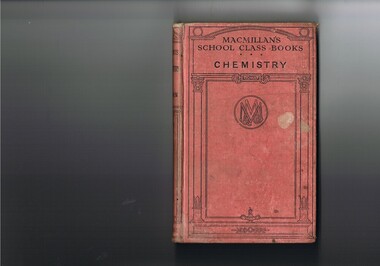
Book - Reference Chemistry, Elements of Chemistry, first printed 1887 this item 1921
... The book acknowledges that although the region was relatively isolated up to the mid 1900s, the good teaching methods of local schools did not suffer in this rural area. This region was not in the backwaters of scholarly development and modern progressive thought. ...This item is a good example of a pre 1960's school science reference books. It contains sketches of experimental apparatus and not colored photographs of later text books. Although the sketches are very instructional they do not show the various colours obtained when mixing some compounds. The history of reprints demonstrates the quality of the information and the ease of study for students using this book. The era of this publication was a time when sources for knowledge in schools was restricted to mainly school books and teacher demonstrations. The student in the 2 Millennium has a far greater reference source available e.g. the internet. This book is significant to the Kiewa Valley as the Davies family (Tas Davies, penned on the first page), belong to the early settlers of the valley. The book acknowledges that although the region was relatively isolated up to the mid 1900s, the good teaching methods of local schools did not suffer in this rural area. This region was not in the backwaters of scholarly development and modern progressive thought. As with "school of the air" distances in rural areas, between centres of learning and recipients, became irrelevant provided that the social stimulant to learn exists. The "local school" mind set within rural areas was, even before the improvement of the communication "explosion" of the early 1900s followed by the internet facilities of the late 1900s, the greatest drive in cutting the anomalies between city and rural learning facilities. Government decentralising higher education facilities into regional centres (Wodonga - Albury) provided greater access for the learned mind.This item (book) has a faded red colour, hard cover with black print and rectangular design. Within this design is an encircled double "M" and "&" (in the left inverted V of the M) and a "Co" (in the right inverted V of the M). On the front cover "MACMILLAN'S SCHOOL CLASS BOOKS CHEMISTRY" and on the spine "ELEMENTS OF CHEMISTRY" underneath "REMSEN" and at the bottom"MACMILLAN & Co"school, chemistry, text books, science experiments -
 Kiewa Valley Historical Society
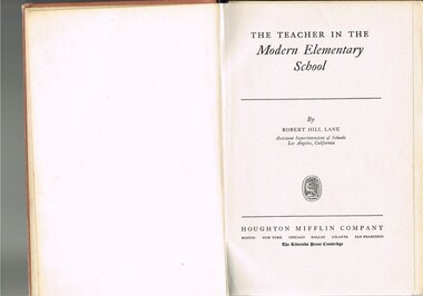
Book - Reference Teaching Infants, The Teacher in the Modern Elementary School, 1941
... school would have children from multi-cultural backgrounds as many of the parents were recruited as labourers or with European technical backgrounds. In the book,the black and white photographs detailing the classroom sizes and configurations point to larger classes and slightly different teaching methods than that which existed in Australia. This teacher's aid book presents the Australian rural teachers with an advanced American approach to teaching methods. These methods were based on the then modern "group" psychological teachings and were a good guide in the development ...This teacher's aid publication was used by the teachers in the The Bogong Primary School from 1941 and also the Mount Beauty Primary School from its establishment in 1947. Both had most of their pupils recruited from SEC(Victoria) Hydro Electricity Scheme employees working for a limited time scale. Rural based children benefited greatly by the decision by the SEC to provide these facilities for their worker's families. This bypass of the "typical rural provisions" offered to other schools, by the Victorian Department of Education was a bonus to the Kiewa Valley educational community. These schools had a higher level of facilities available to them than other "typical" rural schools. Treasured facilities such as a comprehensive library, movie projector, tape recorder and public address system placed these two schools at the level of the Greater Public School of city or the larger towns rather than the small rural schools in Victoria.This item was used in Mount Beauty Primary School as part of a teacher's curriculum. The fact that it is in a rural area, in an enclosed SEC construction worker's village in the Kiewa Valley did present a slightly different learning atmosphere than in the larger towns and cities. The majority of parents within the Kiewa Valley, had a slight resentment of the "high and mighty" attitude of city dwellers with a "plum in their mouths" and the effectiveness that city bred teachers had to achieve was to overcome these ingrained mores. The majority of students at this primary school had parents who were working for (the closed "village" of the SEC Hydro Electricity Scheme. In the 1940s this school would have children from multi-cultural backgrounds as many of the parents were recruited as labourers or with European technical backgrounds. In the book,the black and white photographs detailing the classroom sizes and configurations point to larger classes and slightly different teaching methods than that which existed in Australia. This teacher's aid book presents the Australian rural teachers with an advanced American approach to teaching methods. These methods were based on the then modern "group" psychological teachings and were a good guide in the development of a more effective and progressive teaching platform. The one thing that it did not address was the easy going Australian psyche of "she'll be right mate" of the Australia rural community. The socio-economic identity of the Kiewa Valley rural community was not that of the typical city community (American) and this was a challenge for city based and trained teachers. The principles that the book presents is not constrained by the date of publication or its time of use (1954).This hard cardboard covered book is sleeveless but bound by a red cloth glued onto a thick cardboard base. It has the title printed in gold script on the spine with horizontal and fifteen black horizontal lines at the top and bottom. The front cover has the title printed in gold coloured letters (the first and last words are in freehand script style)On the spine and front cover is printed "The TEACHER IN THE MODERN ELEMENTARY School" school organisation, developmental stages of children, subliminal classroom mental and physical stimulation, usa 1940s teacher aids. -
 Kiewa Valley Historical Society
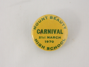
Badge School Carnival, Circa 1970
... School has not only provided outstanding academics but also sports professionals. It has and is still producing a cross section of outstanding Australian men and women. Although the local environment (rural) has limited opportunities for further scholastical and professional sporting achievements it is a vital facility in the student's development for the ever changing Australian society. high school education metal school badges school sports On the front of the badge (in smaller green coloured print) and following the round shape of the badge is "MOUNT BEAUTY HIGH SCHOOL". ...This badge represents a period in time when a School Carnival was not only a major School activity but also had a community "spirit" attached to it. It represents the balance between the metal (learning) and the physical (body) development of the student body. This balance of the growing student has been in existence for centuries. Although some students excel in the academic side of schooling others balance this through the sporting/physical side of "school life" This balance is mirrored in the overall Australian society. From the late 1990's the highly lucrative "professional" sports have provided a highly monetary incentive for those excelling in the physical side of society.The Mount Beauty High School has not only provided outstanding academics but also sports professionals. It has and is still producing a cross section of outstanding Australian men and women. Although the local environment (rural) has limited opportunities for further scholastical and professional sporting achievements it is a vital facility in the student's development for the ever changing Australian society. This yellow coloured, round "lapel" badge is made from mild steel (tin). It has a safety pin shaped around a hole and running horizontal it can be pressed into a "U" shaped hole for fastening onto any material (blazer or shirt).On the front of the badge (in smaller green coloured print) and following the round shape of the badge is "MOUNT BEAUTY HIGH SCHOOL". In the middle portion of the badge, and in larger print "CARNIVAL". Below this in smaller print again is "21st MARCH 1970"high school education, metal school badges, school sports -
 Kiewa Valley Historical Society
Book - Sketch Book, Circa 1918
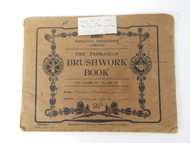
... rural based school children who had limited excursion opportunities available to visit town/city based botanical gardens and museums. This brushwork book is very significant to the Kiewa Valley as it demonstrates that childhood relocations from one State to another were not detrimental to the students overall scholastic development. ...This childhood sketchbook of the 1918 era details the emphasis placed upon a skill of brushwork that portrayed part of the students natural environment both in Tasmanian schools and Victorian schools, especially rural schools. The close bondage between students and their environment was a reflection on the early "hands on" approach in child education. Abstract art or teaching aids which could not be identified with physical properties available to students at this period in time were of lesser value. The ability of the student to identify the artistic value of local nature eg. local plants and flowers was especial important to rural based school children who had limited excursion opportunities available to visit town/city based botanical gardens and museums. This brushwork book is very significant to the Kiewa Valley as it demonstrates that childhood relocations from one State to another were not detrimental to the students overall scholastic development. The rural environment in Tasmania was not that far removed from the rural environment of the Kiewa Valley. The skills taught in both regions were still the same and the socio-economic factors and mores were also similar. This item demonstrates the relocation of one family from Tasmania to the Kiewa Valley. The expansion in population into the Kiewa valley was quite erratic and significant population growth only came after the increase in population brought into the area by the SEC Vic Hydro Scheme introduced to quench the demand for Victoria's electricity.This book has a brown cover with black print and designs on a 150 gsm cardboard. Each page is of the same thickness as the cover but is of paper.On the outside cover and contained within a thick boarder. "EDUCATION DEPARTMENT" and below this in smaller print "TASMANIA" below this "THE TASMANIAN BRUSHWORK BOOK". Below this "FOR CLASSES IV., V., AND VI" Below this "NAME" SCHOOL" At the bottom 2 1/2d1918's educational sketchbook, 1918 children's sketchbook -
 Marysville & District Historical Society
THE TRIANGLE NEWS-VOL 36 NO 37-OCTOBER 2 2009
... school...situations vacant...waste transfer station...community service hub operating hours...spring-season of hope and promise...marysville medical clinic...councillor comment...bushfire affected residents to reap solar hot water rebate...marysville art show...marysville & district football & netball clubs...lakeside fellowship evening...eildon community centre hall...alexandra cinema...murrindindi shire council...youth development and participation officer...mayors chair...marysville community market...gallipoli park...lions triangle tool library...marysville community golf & bowls club...marysville caravan park...your health and wellbeing...public notice...rural...Marysville & District Historical Society 39 Darwin Street Marysville yarra-valley-and-the-dandenong-ranges marysville victoria australia late snow still an attraction marysville marathon dr lachlan fraser what's on when in october buxton cfa buxton community hall annual buxton community christmas bbq buxton reserve football in marysville the marysville & district lions club mtcrc report advertisements marysville marquee mobile kitchens my chef mike catering st michael's grammar school all stars band bpa news had enough community support gathering marysville golf club accredited facilitators graeme & julia cann church notices vale christina barton charcoal drawings of christ church and marysville primary school situations vacant waste transfer station community service hub operating hours spring-season of hope and promise marysville medical clinic councillor comment bushfire affected residents to reap solar hot water rebate marysville art show marysville & district football & netball clubs lakeside fellowship evening eildon community centre hall alexandra cinema murrindindi shire council youth development and participation officer mayors chair marysville community market gallipoli park lions triangle tool library marysville community golf & bowls club marysville caravan park your health and wellbeing public notice rural 1 land buxton progress assocn amnesty period on open air burning marysville junior cricket marysville triangle real estate alexandra clearing sale THE TRIANGLE NEWS-VOL 36 NO 37-OCTOBER 2 2009 ...marysville, victoria, australia, late snow still an attraction, marysville marathon, dr lachlan fraser, what's on when in october, buxton cfa, buxton community hall, annual buxton community christmas bbq, buxton reserve, football in marysville, the marysville & district lions club, mtcrc report, advertisements, marysville marquee, mobile kitchens, my chef mike catering, st michael's grammar school all stars band, bpa news, had enough community support gathering, marysville golf club, accredited facilitators graeme & julia cann, church notices, vale christina barton, charcoal drawings of christ church and marysville primary school, situations vacant, waste transfer station, community service hub operating hours, spring-season of hope and promise, marysville medical clinic, councillor comment, bushfire affected residents to reap solar hot water rebate, marysville art show, marysville & district football & netball clubs, lakeside fellowship evening, eildon community centre hall, alexandra cinema, murrindindi shire council, youth development and participation officer, mayors chair, marysville community market, gallipoli park, lions triangle tool library, marysville community golf & bowls club, marysville caravan park, your health and wellbeing, public notice, rural 1 land, buxton progress assocn, amnesty period on open air burning, marysville junior cricket, marysville triangle real estate, alexandra clearing sale -
 Orbost & District Historical Society
newsletters, Goongerah Grapevine, July 1998 - August 2005
... school no longer functions. These newsletters were produced by members of the community and distributed locally. In small rural communities newsletters have been important tools for facilitating community development while fostering a sense of belonging and attachment to the community. label on front- "COMMUNITY NEWSLETTERS Goongerah 1998 - 2005" A yellow plastic covered folder containing black / white printed newsletters. ...Goongerah is a community on the Brodribb River, located in Gippsland, about seventy kilometres north of Orbost. The town's population is about sixty. Goongerah Post Office opened on 21 November 1952 and closed in 1974. Goongerah had one of the smallest primary schools in Victoria, with about 11 students. The school no longer functions. These newsletters were produced by members of the community and distributed locally.In small rural communities newsletters have been important tools for facilitating community development while fostering a sense of belonging and attachment to the community.A yellow plastic covered folder containing black / white printed newsletters. There are fifteen copies of "Goongerah Community News" and thirty-nine copies of "Goongerah Grapevine". All include news from the C.F.A., Forest News and articles from Goongerah Primary School.label on front- "COMMUNITY NEWSLETTERS Goongerah 1998 - 2005" -
 Narre Warren and District Family History Group
Book, Dot Morrison, 100 years in Skye 1850-1950, 2004
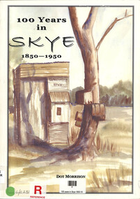
... rural area, underwent significant changes during this period, transitioning from a farming community to a more suburban landscape. The book provides valuable insights into the lives of the early settlers and their contributions to shaping the region's identity. [AI generated text] Skye (Vic.) Skye (Vic.) -- history Skye (Vic.) -- road names Wedge family Skye (Vic.) -- murders South Lyndhurst State School The book 100 Years in Skye, 1850-1950 by Dot Morrison explores the history of Skye in a detailed account of the area's development over a century, including its social, economic, and cultural changes. ...The book 100 Years in Skye, 1850-1950 by Dot Morrison explores the history of Skye in a detailed account of the area's development over a century, including its social, economic, and cultural changes. The book's illustrations, maps, and photographs offer a vivid portrayal of life in Skye during this period. Includes an index and bibliography.99 p.; 29 cmnon-fictionThe book 100 Years in Skye, 1850-1950 by Dot Morrison explores the history of Skye in a detailed account of the area's development over a century, including its social, economic, and cultural changes. The book's illustrations, maps, and photographs offer a vivid portrayal of life in Skye during this period. Includes an index and bibliography.skye (vic.), skye (vic.) -- history, skye (vic.) -- road names, wedge family, skye (vic.) -- murders, south lyndhurst state school -
 Buninyong & District Historical Society
Photograph - Colour Photograph of Mt Helen Campus, Aerial view of University of Ballarat, Mt. Helen Campus c1991
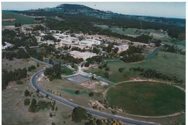
... Buninyong & District Historical Society Old Court House, Buninyong Town Hall 313 Learmonth Street Buninyong goldfields Mount Helen Campus in its later building stages before becoming the University of Ballarat in 1994 The University of Ballarat was formed from a number of varying types of tertiary schools, the earliest being the School of Mines in 1870 and finally became a University in 1994 University of Ballarat Mt. Helen Campus Tertiary Education Mount Buninyong Rural Development Mt. ...Mount Helen Campus in its later building stages before becoming the University of Ballarat in 1994The University of Ballarat was formed from a number of varying types of tertiary schools, the earliest being the School of Mines in 1870 and finally became a University in 1994 Aerial view Mount Helen Campus c1991Mt. Helen Campus. Aerial view to Mt. Buninyong c. 1991university of ballarat, mt. helen campus, tertiary education, mount buninyong, rural development -
 Bayside Gallery - Bayside City Council Art & Heritage Collection
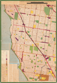
Map - print, Melbourne and Metropolitan Board of Works, Interim development order: Brighton, Moorabbin and Sandringham, 1959
... development order Bayside Print. The coloured map shows planning and municipal boundaries, rural, village and residential zones, businesses, industry, transportation. It also shows open spaces, public purposes (eg, hospitals, schools ...The Melbourne and Metropolitan Board of Works (now Melbourne Water) was established in 1891. From that time, as part of their work laying water and sewerage connections, they created detailed plans of houses and other buildings in the Melbourne metropolitan area. In 1956 it acquired powers to construct and maintain highways and bridges, protect and improve the foreshores and create and maintain parks within the metropolitan region. This Interim development order comprises part of the municipalities of Brighton, Moorabbin and Sandringham and was made on 20 October 1959.brighton, moorabbin, sandringham, melbourne and metropolitan board of works, map, town planning, cartographic material, interim development order, bayside -
Broadmeadows Historical Society & Museum
Photograph - Aerial Photograph
... rural area with agricultural roots, but since the late 20th century, it has undergone significant urban development. The transformation accelerated in the 1990s and 2000s, with large-scale residential subdivisions, infrastructure projects, and commercial developments reshaping the landscape. Key historical milestones include: Early Settlement: Originally inhabited by the Wurundjeri people of the Kulin Nation. European Settlement: Began in the mid-1800s, primarily for farming and grazing. Urban Expansion: Post-1970s, Craigieburn saw increasing suburban development, especially after the extension of rail and road infrastructure. Recent Growth: From the 2000s onward, Craigieburn became one of Melbourne’s fastest-growing suburbs, with new estates, schools...rural area with agricultural roots, but since the late 20th century, it has undergone significant urban development. The transformation accelerated in the 1990s and 2000s, with large-scale residential subdivisions, infrastructure projects, and commercial developments reshaping the landscape. Key historical milestones include: Early Settlement: Originally inhabited by the Wurundjeri people of the Kulin Nation. European Settlement: Began in the mid-1800s, primarily for farming and grazing. Urban Expansion: Post-1970s, Craigieburn saw increasing suburban development, especially after the extension of rail and road infrastructure. Recent Growth: From the 2000s onward, Craigieburn became one of Melbourne’s fastest-growing suburbs, with new estates, schools ...Craigieburn is a rapidly growing suburb located approximately 25 km north of Melbourne’s CBD. Historically, it was a rural area with agricultural roots, but since the late 20th century, it has undergone significant urban development. The transformation accelerated in the 1990s and 2000s, with large-scale residential subdivisions, infrastructure projects, and commercial developments reshaping the landscape. Key historical milestones include: Early Settlement: Originally inhabited by the Wurundjeri people of the Kulin Nation. European Settlement: Began in the mid-1800s, primarily for farming and grazing. Urban Expansion: Post-1970s, Craigieburn saw increasing suburban development, especially after the extension of rail and road infrastructure. Recent Growth: From the 2000s onward, Craigieburn became one of Melbourne’s fastest-growing suburbs, with new estates, schools, and shopping centres.This large colour aerial photograph of Craigieburn holds significant value as a visual record of the suburb’s transformation from a semi-rural landscape to a dynamic urban centre in Melbourne’s northern growth corridor. Captured during a period of rapid development, the image documents the spatial evolution of Craigieburn, including residential expansion, infrastructure projects, and the integration of green spaces and commercial zones. The photograph is historically significant as it reflects the broader patterns of post-2000 suburban growth in Victoria, driven by population pressures, housing demand, and strategic planning initiatives. It provides insight into land use changes, transport connectivity (notably the Hume Highway and Craigieburn railway line), and the emergence of community hubs such as Craigieburn Central. From a cultural heritage perspective, the image contributes to understanding the lived environment of diverse communities who have settled in Craigieburn, including its role in accommodating Melbourne’s multicultural population. It also serves as a reference point for future urban planning, environmental monitoring, and historical comparison. The photograph is an important archival asset for researchers, planners, and local historians, offering a detailed snapshot of a pivotal moment in Craigieburn’s development trajectory.Colour aerial photograph of Craigieburnaerial photograph, craigieburn -
 Wodonga & District Historical Society Inc
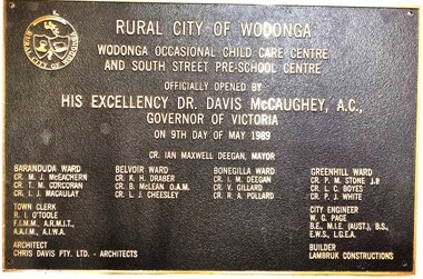
Plaque - Official Opening of the Child Care Centre & South Street Pre-School, Wodonga
... development in the provision of pre-school and child care services in Wodonga. Child care facilities Wodonga Children's services Wodonga Pre-schools Wodonga This training module was available to enginemen who had completed Modules 1 to 5 (1983 Scheme). The manual contained fault finding checklists and standard procedures to be carried out if faults occured. Every driver was required to be conversant with and follow the instructions. Enginemen issued with this manual had to carry it with them at all times when in charge of a diesel electric locomotive. "RURAL ...This plaque commemorates the official opening of an occasional child care centre and pre-school in South St, Wodonga in 1989 by the Governor of Victoria Dr. Davis McCaughey. With strong population growth in Wodonga community services had expanded rapidly throughout the 1980s. The first child minding centre had opened in 1975. BY 1987 Upper Murray Family Care provided full-day family day care and occasional care and there were also 2 private child care centres. By 1986 there were 350 full-time places and 75 part-time places, but pre-schools were unable to fill the demand for another 511 applicants. This new facility helped to ease a little of the problem. As well as the inscription included here, the name of the Mayor, all members of the Wodonga Council, City Engineer, Architect and Builder are listed on the plaque.This item illustrates an important development in the provision of pre-school and child care services in Wodonga.A bronze rectangular plaque with detailed inscription, designed to be attached to the wall of a building. There is a hole in each corner for bolts to be inserted. The text is raised above the surface of the plaque. It features the symbol of the shield of the Rural City of Wodonga in the top left corner.fiction"RURAL CITY OF WODONGA WODONGA OCCASIONAL CHILD CARE CENTRE AND SOUTH STREET PRE-SCHOOL CENTRE OFFICIALLY OPENED BY HIS EXCELLENCY DR. DAVIS MCCAUGHEY, A.C., GOVERNOR OF VICTORIA ON 9TH DAY OF MAY 1989child care facilities wodonga, children's services wodonga, pre-schools wodonga -
 Whitehorse Historical Society Inc.
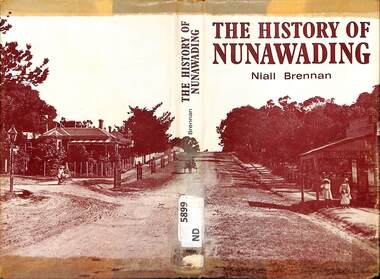
Book - Historical Resource, Niall Brennan, The History of Nunawading, 1972
... Rural Shire, and then became part of the City of Whitehorse. Shire of Nunawading Blackburn Vermont Mitcham Nunawading This book covers the civic and industrial development of the shire of Nunawading since the first overlanders in 1830's. It includes photographs, maps, a bibliography and an index. Stamps: Rectangular Blackburn High School ...This book covers the civic and industrial development of the shire of Nunawading since the first overlanders in 1830's. It includes photographs, maps, a bibliography and an index.This book covers the civic and industrial development of the shire of Nunawading since the first overlanders in 1830's. It includes photographs, maps, a bibliography and an index.non-fictionThis book covers the civic and industrial development of the shire of Nunawading since the first overlanders in 1830's. It includes photographs, maps, a bibliography and an index.shire of nunawading, blackburn, vermont, mitcham, nunawading -
City of Kingston
Photograph - Colour, 31 January 1993
... development would give the suburb's homeowners access to Port Phillip Bay "from their back door". Circa 1974, the area was rezoned from rural to residential and named Patterson Lakes. Development has been continuous since the 1970s with construction of residential housing, schools ...Patterson Lakes is a suburb in the City of Kingston that is built one kilometre upstream of the mouth of the Patterson River. The area is bordered by the Patterson River and Eel Race Drain which enters the Kananook Creek. The suburb consists predominantly of newer housing developments and the tidal canal system of the development joins Port Phillip Bay. Patterson Lakes and the Kananook Creek were previously part of the extensive Carrum Carrum Swamp. The area was once a source of fish and eels for the Mayone-Bulluk clan of the Bunurong people. Over time the area was drained and in 1973 investigations commenced into the development of a unique residential area that would be built adjacent to canals and waterways. It was originally proposed to be known as "Gladesville". The development would give the suburb's homeowners access to Port Phillip Bay "from their back door". Circa 1974, the area was rezoned from rural to residential and named Patterson Lakes. Development has been continuous since the 1970s with construction of residential housing, schools, shopping centres, marinas, a hotel and library.Laminated colour aerial photograph of the Carrum and Patterson Lakes region within City of Kingston. This 1993 image includes Patterson River Secondary College, Roy Dore Reserve, Kananook Creek and Nepean Highway. The railway line can be seen as it veers inland from Eel Race Road, Seaford. The section of Ocean Reef Drive and Palm Beach Drive in Patterson Lakes appears to be a recent development with many spare blocks and new houses under construction.Black typed lettering on white adhesive label: 31.1.93 Black typed lettering on white adhesive label: 27E/7140 31/1/93 12.55 pm Black typed lettering on white label: 7140 Yellow round adhesive label located on left sidepatterson lakes, seaford, kananook creek, carrum carrum swamp, canals and waterways -
City of Kingston
Photograph - Colour, c. 1993
... development would give the suburb's homeowners access to Port Phillip Bay "from their back door". Circa 1974, the area was rezoned from rural to residential and named Patterson Lakes. Development has been continuous since the 1970s with construction of residential housing, schools ...Patterson Lakes is a suburb in the City of Kingston that is built one kilometre upstream of the mouth of the Patterson River. The area is bordered by the Patterson River and Eel Race Drain which enters the Kananook Creek. The suburb consists predominantly of newer housing developments and the tidal canal system of the development joins Port Phillip Bay.Patterson Lakes and the Kananook Creek were previously part of the extensive Carrum Carrum Swamp. The area was once a source of fish and eels for the Mayone-Bulluk clan of the Bunurong people. Over time the area was drained and in 1973 investigations commenced into the development of a unique residential area that would be built adjacent to canals and waterways. It was originally proposed to be known as "Gladesville". The development would give the suburb's homeowners access to Port Phillip Bay "from their back door". Circa 1974, the area was rezoned from rural to residential and named Patterson Lakes. Development has been continuous since the 1970s with construction of residential housing, schools, shopping centres, marinas, a hotel and library.Laminated colour aerial photograph of the Carrum and Patterson Lakes region within City of Kingston. This 1993 image includes Patterson River Secondary College, Roy Dore Reserve, Kananook Creek and Nepean Highway. The railway line can be seen as it veers inland from Eel Race Road, Seaford. The section of Palm Beach Drive, Curlew Point Drive, Snapper Point Drive, Clipper Island and Myola Street in Patterson Lakes appears to be a recent development with many spare blocks and new houses under construction.patterson lakes, seaford, kananook creek, carrum carrum swamp, canals and waterways -
City of Kingston
Photograph - Colour, 29 January 1993
... rural to residential and named Patterson Lakes. Development has been continuous since the 1970s with staged construction of the waterways, residential housing, and supporting infrastructure and facilities. Bonbeach Carrum Patterson Lakes Patterson River Carrum Carrum Swamp Canals and waterways Black type on white adhesive sticker: No. 6661 Black type on white adhesive sticker: 26E/6661, 29/1/93, 4.25 pm Black type on white adhesive sticker 29-1-93 Yellow circular adhesive sticker Laminated colour aerial photograph of the Bonbeach, Carrum and Patterson Lakes region within City of Kingston. This 1993 image includes Bonbeach High School ...Bonbeach, Carrum and Patterson Lakes are suburbs in the City of Kingston. Bonbeach and Carrum were holiday destinations in early 20th century and over time the housing has converted to permanent residential structures. In Patterson Lakes, the area consists predominantly of newer housing developments and the tidal canal system which is accessible to many dwellings joins Port Phillip Bay.Bonbeach, Carrum and Patterson Lakes were previously part of the extensive Carrum Carrum Swamp. The area was once a source of fish and eels for the Mayone-Bulluk clan of the Bunurong people. Over time the area was drained and this allowed farming at Carrum and Bonbeach, although the area was prone to flooding. In the early 1920s and 30s the land was converted to residential dwellings. In 1973 investigations commenced nearby to Bonbeach and Carrum into the development of a unique residential area comprising canals and waterways. It was originally proposed to be known as "Gladesville". Circa 1974, the area was rezoned from rural to residential and named Patterson Lakes. Development has been continuous since the 1970s with staged construction of the waterways, residential housing, and supporting infrastructure and facilities.Laminated colour aerial photograph of the Bonbeach, Carrum and Patterson Lakes region within City of Kingston. This 1993 image includes Bonbeach High School prior to demolition, Bonbeach Primary School and Patterson River Golf Club. Sections of Patterson Lakes are not yet developed, including Rhode and Staten Islands. Long Island Point appears to be a recent development with many spare blocks and new houses under construction. The Patterson River marina is prominent and the river mouth as it meets Port Phillip Bay. The Carrum railway station is visible.Black type on white adhesive sticker: No. 6661 Black type on white adhesive sticker: 26E/6661, 29/1/93, 4.25 pm Black type on white adhesive sticker 29-1-93 Yellow circular adhesive stickerbonbeach, carrum, patterson lakes, patterson river, carrum carrum swamp, canals and waterways -
 Wodonga & District Historical Society Inc
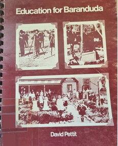
Book - Education for Baranduda, David Pettit, 1976
... Baranduda Albury-Wodonga Development Corporation Education North East Victoria This book is the result of research commissioned by the Albury-Wodonga Development Corporation in 1976 to investigate future educational needs for the Baranduda community, Baranduda was established as a pastoral run around 1846. It developed as a rural community in the late 19th century—with a school ...This book is the result of research commissioned by the Albury-Wodonga Development Corporation in 1976 to investigate future educational needs for the Baranduda community, Baranduda was established as a pastoral run around 1846. It developed as a rural community in the late 19th century—with a school opening in 1880. In 1974 The Albury-Wodonga Development Corporation was established to transform the twin-town border region into a major inland city, aiming for a population of 300,000 by 2000. It was created by federal and state governments to decentralise population from capital cities, manage regional land development, and boost local industry. As part of its recommendations Baranduda was designated for development as a modern satellite township. This report was commissioned as part of the planning for the future development of the Baranduda community.A spiral bound publication of 110 pages investigating potential plans and developments of education in Baranduda, Victoria. Cover features 3 photographs and diagrams are included.This book is the result of research commissioned by the Albury-Wodonga Development Corporation in 1976 to investigate future educational needs for the Baranduda community, Baranduda was established as a pastoral run around 1846. It developed as a rural community in the late 19th century—with a school opening in 1880. In 1974 The Albury-Wodonga Development Corporation was established to transform the twin-town border region into a major inland city, aiming for a population of 300,000 by 2000. It was created by federal and state governments to decentralise population from capital cities, manage regional land development, and boost local industry. As part of its recommendations Baranduda was designated for development as a modern satellite township. This report was commissioned as part of the planning for the future development of the Baranduda community.baranduda, albury-wodonga development corporation, education north east victoria -
Marysville & District Historical Society
THE TRIANGLE NEWS-VOL 40 NO 19-MAY 24 2013
... rural development...peter ryan...what's on when in may and june...buxton recreational reserve...working bee...intrepid triangle bushwalkers...the committee of management of the gallipoli park precinct...marysville community market...creative triangle...fire services levy now part of rates notices...church notices...triangle community dinner...el kanah village...biggest morning tea a success...vale brian moore...murrindindi shire council...payment of rate installment...position vacant...mayor's chair...marysville primary school...marysville victoria australia $28 million vibe hotel marsyville breaks ground deputy premier and minister for regional & rural development peter ryan what's on when in may and june buxton recreational reserve working bee intrepid triangle bushwalkers the committee of management of the gallipoli park precinct marysville community market creative triangle fire services levy now part of rates notices church notices triangle community dinner el kanah village biggest morning tea a success vale brian moore murrindindi shire council payment of rate installment position vacant mayor's chair marysville primary school mother's day raffle advertisements buxton fire brigade anna's mobile patchwork quilt shop open capital works program supports existing infrastructure villains storm home to first ever away victory staff wanted black spur inn greenlands guesthouse open by lachlan fraser building our future draft council plan released for comment emotions anonymous international buxton hotel real estate marysville golf report snowgum hillary challenge comes to marysville last quarter assault gets villains home free mulch loading triangle community dance group marysville villains sponsors and members lunch randy the puppet is back for lunch draft council plan and budget have your say melbourne international comedy festival marysville & district lions club road maintenance and construction works free information session council delivers conservative draft budget yarra valley div 1 game in marysville a success THE TRIANGLE NEWS-VOL 40 NO 19-MAY 24 2013 ...marysville, victoria, australia, $28 million vibe hotel marsyville breaks ground, deputy premier and minister for regional & rural development, peter ryan, what's on when in may and june, buxton recreational reserve, working bee, intrepid triangle bushwalkers, the committee of management of the gallipoli park precinct, marysville community market, creative triangle, fire services levy now part of rates notices, church notices, triangle community dinner, el kanah village, biggest morning tea a success, vale brian moore, murrindindi shire council, payment of rate installment, position vacant, mayor's chair, marysville primary school mother's day raffle, advertisements, buxton fire brigade, anna's mobile patchwork quilt shop open, capital works program supports existing infrastructure, villains storm home to first ever away victory, staff wanted black spur inn, greenlands guesthouse open by lachlan fraser, building our future draft council plan released for comment, emotions anonymous international, buxton hotel, real estate, marysville golf report, snowgum hillary challenge comes to marysville, last quarter assault gets villains home, free mulch loading, triangle community dance group, marysville villains sponsors and members lunch, randy the puppet is back for lunch, draft council plan and budget have your say, melbourne international comedy festival, marysville & district lions club, road maintenance and construction works free information session, council delivers conservative draft budget, yarra valley div 1 game in marysville a success