Showing 190 items matching "sandhurst maps"
-
 Bendigo Historical Society Inc.
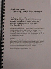
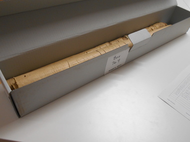
Book - SANDHURST MAPS, 1870s
... SANDHURST MAPS......Sandhurst Maps...Sandhurst Maps Prepared by George Black Surveyor. ...History House 11 Mackenzie Street Bendigo goldfields George Black Sandhurst Maps 1870 Sandhurst Maps Prepared by George Black Surveyor. ...Sandhurst Maps Prepared by George Black Surveyor. Enlarged from original survey Field Book. Prepared by Carol Holsworth December 2011george black, sandhurst maps, 1870 -
 Bendigo Historical Society Inc.
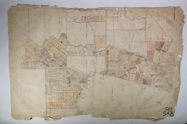
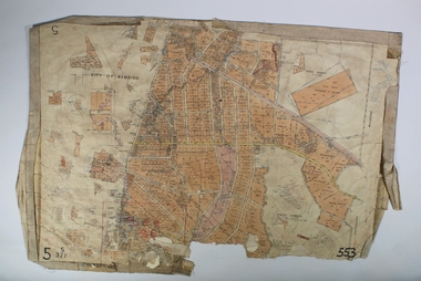
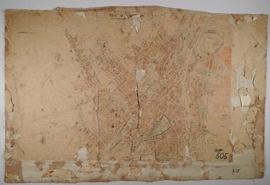
Map - SANDHURST (PART), Circa 1900
... MAP...Bendigo...parish plan...Sandhurst...Map: Sandhurst ( part), sheet No., Missing...History House 11 Mackenzie Street Bendigo goldfields MAP Bendigo parish plan Sandhurst Map: Sandhurst ( part), sheet No., Missing Map SANDHURST (PART) ...Map: Sandhurst ( part), sheet No., Missingmap, bendigo, parish plan, sandhurst -
 Bendigo Historical Society Inc.
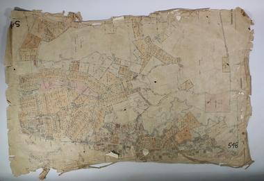
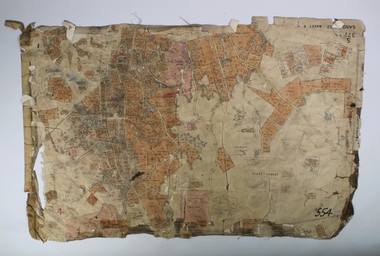
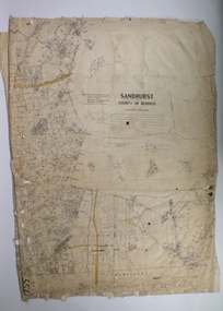
Map - SANDHURST,. SHEET ?, 24/04/1907 ?
... MAP...Bendigo...parish plan...Sandhurst...Map: Sandhurst (sheet No. missing). Parish plan...History House 11 Mackenzie Street Bendigo goldfields MAP Bendigo parish plan Sandhurst Map: Sandhurst (sheet No. missing). Parish plan Map SANDHURST,. ...Map: Sandhurst (sheet No. missing). Parish planmap, bendigo, parish plan, sandhurst -
 Bendigo Historical Society Inc.
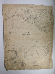
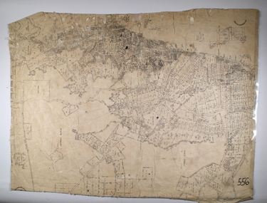
Map - SANDHURST SHEET 4, 11/03/1925
... MAP...Bendigo...parish plan...Sandhurst...Map: Sandhurst sheet 4. Parish plan...History House 11 Mackenzie Street Bendigo goldfields MAP Bendigo parish plan Sandhurst Map: Sandhurst sheet 4. Parish plan Map SANDHURST SHEET 4 ...Map: Sandhurst sheet 4. Parish planmap, bendigo, parish plan, sandhurst -
 Bendigo Historical Society Inc.
Map - SANDHURST, SHEET ?, Date missing
... MAP...Bendigo...parish plan...Sandhurst...Map: Sandhurst (sheet No., Missing) P_arish plan...History House 11 Mackenzie Street Bendigo goldfields MAP Bendigo parish plan Sandhurst Map: Sandhurst (sheet No., Missing) P_arish plan Map SANDHURST, SHEET ? ...Map: Sandhurst (sheet No., Missing) P_arish planmap, bendigo, parish plan, sandhurst -
 Bendigo Historical Society Inc.
Map - SANDHURST SHEET 4, No date visible
... MAP...Bendigo...parish plan...Sandhurst...Map: Sandhurst sheet 4. Parish plan...History House 11 Mackenzie Street Bendigo goldfields MAP Bendigo parish plan Sandhurst Map: Sandhurst sheet 4. Parish plan Map SANDHURST SHEET 4 ...Map: Sandhurst sheet 4. Parish planmap, bendigo, parish plan, sandhurst -
 Bendigo Historical Society Inc.
Map - SANDHURST SHEET 2, 14/03/1923 ?
... MAP...Bendigo...parish plan...Sandhurst...Map: Sandhurst sheet 2. Parish plan...History House 11 Mackenzie Street Bendigo goldfields MAP Bendigo parish plan Sandhurst Map: Sandhurst sheet 2. Parish plan Map SANDHURST SHEET 2 ...Map: Sandhurst sheet 2. Parish planmap, bendigo, parish plan, sandhurst -
 Bendigo Historical Society Inc.
Map - SANDHURST SHEET 2, Date unreadable
... MAP...Bendigo...parish plan...Sandhurst...Map: Sandhurst sheet 2. Parish plan...History House 11 Mackenzie Street Bendigo goldfields MAP Bendigo parish plan Sandhurst Map: Sandhurst sheet 2. Parish plan Map SANDHURST SHEET 2 ...Map: Sandhurst sheet 2. Parish planmap, bendigo, parish plan, sandhurst -
 Bendigo Historical Society Inc.
Map - SANDHURST SHEET 3, June 29th 1967
... MAP...Bendigo...city streets...Sandhurst...Map: Sandhurst sheet 3. Parish plan....History House 11 Mackenzie Street Bendigo goldfields MAP Bendigo city streets Sandhurst Early Bendigo Map: Sandhurst sheet 3. ...Map: Sandhurst sheet 3. Parish plan.map, bendigo, city streets, sandhurst, early bendigo -
 Bendigo Historical Society Inc.
Map - SANDHURST SHEET 2, March 12th 1867
... MAP...Bendigo...city streets...Sandhurst...Map: Sandhurst sheet 2 . Parish plan....History House 11 Mackenzie Street Bendigo goldfields MAP Bendigo city streets Sandhurst Early bendigo Map: Sandhurst sheet 2 . ...Map: Sandhurst sheet 2 . Parish plan.map, bendigo, city streets, sandhurst, early bendigo -
 Bendigo Historical Society Inc.
Map - SANDHURST SHEETS 1 AND 2, No date visible
... MAP...Bendigo...parish plan...Sandhurst...Map: Sandhurst sheets 1 and 2. Parish plan...History House 11 Mackenzie Street Bendigo goldfields MAP Bendigo parish plan Sandhurst Map: Sandhurst sheets 1 and 2. Parish plan Map SANDHURST SHEETS 1 AND 2 ...Map: Sandhurst sheets 1 and 2. Parish planmap, bendigo, parish plan, sandhurst -
 Bendigo Historical Society Inc.
Map - SANDHURST SHEET 1, 27/05/1925
... MAP...Bendigo...parish plan...Sandhurst...Map: Sandhurst ,County of Bendigo, sheet 1. Parish plan...Parish plan Map SANDHURST SHEET 1 ...Map: Sandhurst ,County of Bendigo, sheet 1. Parish planmap, bendigo, parish plan, sandhurst -
 Bendigo Historical Society Inc.
Map - SANDHURST SHEET 3, 27/05/1925
... MAP...Bendigo...parish plan...Sandhurst...Map: sandhurst sheet 3. Parish plan ( number 202 in Map Cupboard 1)...History House 11 Mackenzie Street Bendigo goldfields MAP Bendigo parish plan Sandhurst Map: sandhurst sheet 3. Parish plan ( number 202 in Map Cupboard 1) Map SANDHURST SHEET 3 ...Map: sandhurst sheet 3. Parish plan ( number 202 in Map Cupboard 1)map, bendigo, parish plan, sandhurst -
Bendigo Historical Society Inc.
Map - SANDHURST SHEET 3, No date visible
... MAP...Bendigo...city streets...Sandhurst...Map: Sandhurst sheet 3. Parish plan ( number 199 in Map Cupboard 1)...History House 11 Mackenzie Street Bendigo goldfields MAP Bendigo city streets Sandhurst Map: Sandhurst sheet 3. Parish plan ( number 199 in Map Cupboard 1) Map SANDHURST SHEET 3 ...Map: Sandhurst sheet 3. Parish plan ( number 199 in Map Cupboard 1)map, bendigo, city streets, sandhurst -
Bendigo Historical Society Inc.
Map - SANDHURST SHEET 4, January 1947
... MAP...Bendigo...city streets...Sandhurst...Map: Sandhurst sheet 4. Parish plan ( number 198 in Map Cupboard 1)...History House 11 Mackenzie Street Bendigo goldfields MAP Bendigo city streets Sandhurst Map: Sandhurst sheet 4. Parish plan ( number 198 in Map Cupboard 1) Map SANDHURST SHEET 4 ...Map: Sandhurst sheet 4. Parish plan ( number 198 in Map Cupboard 1)map, bendigo, city streets, sandhurst -
Bendigo Historical Society Inc.
Map - SANDHURST SHEET 5, Circa 1940's
... MAP...Bendigo...city streets...Sandhurst...Map: Sandhurst sheet 5. Parish plan ( number 197 in Map Cupboard 1)...History House 11 Mackenzie Street Bendigo goldfields MAP Bendigo city streets Sandhurst Map: Sandhurst sheet 5. Parish plan ( number 197 in Map Cupboard 1) Map SANDHURST SHEET 5 ...Map: Sandhurst sheet 5. Parish plan ( number 197 in Map Cupboard 1)map, bendigo, city streets, sandhurst -
Bendigo Historical Society Inc.
Map - SANDHURST SHEET 6, 1947
... MAP...Bendigo...city streets...Sandhurst...Map: Sandhurst sheet 6. Parish plan ( number 196 in Map Cupboard 1)...History House 11 Mackenzie Street Bendigo goldfields MAP Bendigo city streets Sandhurst Map: Sandhurst sheet 6. Parish plan ( number 196 in Map Cupboard 1) Map SANDHURST SHEET 6 ...Map: Sandhurst sheet 6. Parish plan ( number 196 in Map Cupboard 1)map, bendigo, city streets, sandhurst -
Bendigo Historical Society Inc.
Map - SANDHURST SHEET 1, No date visible
... MAP...Bendigo...city streets...Sandhurst...Map: Sandhurst ,County of Bendigo sheet 1. Parish plan ( number 201 in Map Cupboard 1)...Parish plan ( number 201 in Map Cupboard 1) Map SANDHURST SHEET 1 ...Map: Sandhurst ,County of Bendigo sheet 1. Parish plan ( number 201 in Map Cupboard 1)map, bendigo, city streets, sandhurst -
Bendigo Historical Society Inc.
Map - SANDHURST GOLD FIELD SHEET NO. 1, 18th June 1873
... MAP...Bendigo...mining plan...Sandhurst...Map: Sandhurst Gold Field sheet No. 1, Showing lands held under lease for Gold Mining ( number 221 in Map Cupboard 1)...History House 11 Mackenzie Street Bendigo goldfields MAP Bendigo mining plan Sandhurst Gold Field Lease for Gold Mining Map: Sandhurst Gold Field sheet No. 1, Showing lands held under lease for Gold Mining ( number 221 in Map Cupboard 1) Map SANDHURST GOLD FIELD SHEET NO. 1 ...Map: Sandhurst Gold Field sheet No. 1, Showing lands held under lease for Gold Mining ( number 221 in Map Cupboard 1)map, bendigo, mining plan, sandhurst gold field, lease for gold mining -
 Bendigo Historical Society Inc.
Map - CAMPBELL COLLECTION: BENDIGO AND DISTRICT MAPS
... Map. Sandhurst and suburbs, Parish of Sandhurst, Parish of Huntly, Parish of Nerring, Parish of Marong, Parish of Lockwood, Parish of Wellsford, Parish of Strathfieldsaye, Parish of Mandurang...MAP Bendigo parishes Map. Sandhurst and suburbs, Parish of Sandhurst, Parish of Huntly, Parish of Nerring, Parish of Marong, Parish of Lockwood, Parish of Wellsford, Parish of Strathfieldsaye, Parish of Mandurang Map CAMPBELL COLLECTION: BENDIGO AND DISTRICT MAPS. ...Map. Sandhurst and suburbs, Parish of Sandhurst, Parish of Huntly, Parish of Nerring, Parish of Marong, Parish of Lockwood, Parish of Wellsford, Parish of Strathfieldsaye, Parish of Mandurangmap, bendigo, parishes -
Bendigo Historical Society Inc.
Map - PORTION OF SANDHURST, 27/01/1877
... MAP...Bendigo...parish plan...Sandhurst...Map: Hand draughted parish plan, showing a portion of the City of Sandhurst ( number 225 in Map Cupboard 1)...History House 11 Mackenzie Street Bendigo goldfields MAP Bendigo parish plan Sandhurst Map: Hand draughted parish plan, showing a portion of the City of Sandhurst ( number 225 in Map Cupboard 1) Map PORTION OF SANDHURST ...Map: Hand draughted parish plan, showing a portion of the City of Sandhurst ( number 225 in Map Cupboard 1)map, bendigo, parish plan, sandhurst -
 Bendigo Historical Society Inc.
Map - MARKS COLLECTION: MAP SANDHURST 1867
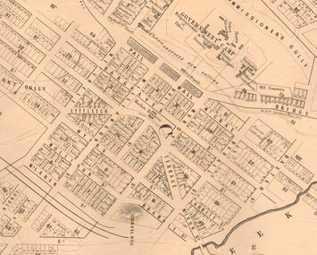
... MARKS COLLECTION: MAP SANDHURST 1867......1867 sandhurst map...Original map: Sandhurst 1867, shows central Bendigo and surrounds, including police camp, stockade, 'old cemetery', reserve for. ...On top RH corner 'Sheet No 1 Sandhurst'. Map MARKS COLLECTION: MAP SANDHURST 1867 ...Original map: Sandhurst 1867, shows central Bendigo and surrounds, including police camp, stockade, 'old cemetery', reserve for. On bottom of map: 'Lithographed at the Department of Lands and Survey by D. Henderson, 20 February, 1867'. On top RH corner 'Sheet No 1 Sandhurst'.map, bendigo, 1867 sandhurst map -
Bendigo Historical Society Inc.
Map - SANDHURST : COUNTY OF BENDIGO, 12-7-27
... MAP...Bendigo...sandhurst...Map. Sandhurst, County of Bendigo. Scale 20 chains to an inch. ...History House 11 Mackenzie Street Bendigo goldfields MAP Bendigo sandhurst H.J. Green, Govt. Printer. Map. ...Map. Sandhurst, County of Bendigo. Scale 20 chains to an inch. Huntly, Nerring, Marong, Mandurang, Strathfieldsaye, Wellsford, City of Bendigo. Photo-Lithographed at the Department of Lands and Survey, Melbourne by W.J. Butson12-7-27. Price 1/-. By authority H.J. Green, Govt. Printer. (number 33 in map cupboard 1)H.J. Green, Govt. Printer.map, bendigo, sandhurst -
Bendigo Historical Society Inc.
Map - BENDIGO AND DISTRICT PARISH MAPS, 21-10-26
... MAP...Bendigo...sandhurst...Map. Sandhurst, County of Bendigo, City of Bendigo, Strathfieldsaye, Mandurang, Marong, Nerring, Borough of Eaglehawk, Township of Kangaroo Flat, Lockwood, Huntly, Epsom, Wellsford. ...History House 11 Mackenzie Street Bendigo goldfields MAP Bendigo sandhurst By Authority H.J. Green, Govt. ...Map. Sandhurst, County of Bendigo, City of Bendigo, Strathfieldsaye, Mandurang, Marong, Nerring, Borough of Eaglehawk, Township of Kangaroo Flat, Lockwood, Huntly, Epsom, Wellsford. By Authority H.J. Green, Government Printer, Photo-Lithographed at the Department of Lands and Survey, Melbourne bj W.J Butson 21-10-26,Price 1/-. (number 13 in map cupboard 1)By Authority H.J. Green, Govt. Printermap, bendigo, sandhurst -
 Bendigo Historical Society Inc.
Map - LONG GULLY HISTORY GROUP COLLECTION: SANDHURST AT BENDIGO
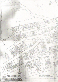
... Copy of a map titled Sandhurst at Bendigo, Parish of Sandhurst, County of Bendigo. ...History House 11 Mackenzie Street Bendigo goldfields BENDIGO History long gully history group The Long Gully History Group - Sandhurst at Bendigo Copy of a map titled Sandhurst at Bendigo, Parish of Sandhurst, County of Bendigo. ...Copy of a map titled Sandhurst at Bendigo, Parish of Sandhurst, County of Bendigo. Some of the street names are: Quick, Rae, Casley, Bell. Thomas, Victoria, Roeder and Prout Streets. Allotments have the date, size, measurements and names on them. Some are unreadable.bendigo, history, long gully history group, the long gully history group - sandhurst at bendigo -
 Bendigo Historical Society Inc.
Document - MARKS COLLECTION: MINING LEASE BLOCKS 1873
... Number linked to the mine site shown on Sandhurst Gold Field map....Number linked to the mine site shown on Sandhurst Gold Field map. Document MARKS COLLECTION: MINING LEASE BLOCKS 1873 ...Plan mining lease blocks 1873, timber hanger on top two brass rings, securing tape, round timber holder on bottom, scroll. On top Schedule of Mining Lease Blocks shown on the plan of the Sandhurst Gold Field, Published May 1873' Names of mining Companies listed with identifying number and area of mine site. E.g. '447 Johnson's Reef Gold Mines 7a, 2r, 8 p (acres, roods, perches). Number linked to the mine site shown on Sandhurst Gold Field map.bendigo, mining, mining lease blocks 1873 -
 Bendigo Historical Society Inc.
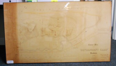
Map - CONTOUR PLAN OF THE GOVERNMENT CAMP SANDHURST 1854, 1994
... MAP...Bendigo...government camp...Pall Mall... Bendigo Creek... Commissioner's Gully... View Place (now View Street)... Post Office... Bank of Victoria... District Surgeon... Sandhurst...Contour map (copy) of the Government Camp Sandhurst, 1854. Map is mounted on coreflute and laminated. ...Survey and Mapping Victoria. Sandhurst Bendigo. Contour map (copy) of the Government Camp Sandhurst, 1854. ...Contour map (copy) of the Government Camp Sandhurst, 1854. Map is mounted on coreflute and laminated. Written in bottom righthand corner 'Contour Plan of the Government Camp, Sandhurst. Dec 1854. Signed by Richard Larritt, Assistant Surveyor, 11th December 1854.' Shown on map: Pall Mall, Bendigo Creek, Commissioner's Gully, View Place (now View Street), Post Office, Bank of Victoria, District Surgeon, Sandhurst Fire Brigade, Police Hospital, Flagstaff, Gold Office, License Shed, Military Barracks, Stables, Commissioner's Buildings, Police Office. Old Cemetery, Garden. Reference on righthand side: 'Stone or brick buildings are tinted in crimson. Wooden buildings tinted in Indian Ink. Tents and other temporary structures tinted in Burnt Sienna.' Scale of Chains, on bottom of map. Sticker on bottom left hand corner and back of map ' Presented by Survey and Mapping, Victoria, 7th Octber, 1994'.map, bendigo, government camp, pall mall, bendigo creek, commissioner's gully, view place (now view street), post office, bank of victoria, district surgeon, sandhurst fire brigade, police hospital, flagstaff, gold office, license shed, military barracks, stables, commissioner's buildings, police office. old cemetery, garden. , survey and mapping victoria. sandhurst, bendigo. -
 Bendigo Historical Society Inc.
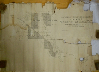
Map - MARKS COLLECTION: TRAMWAY OR RAILWAY MAP SANDHURST
... MARKS COLLECTION: TRAMWAY OR RAILWAY MAP SANDHURST...On bottom RH corner, is small map of Sandhurst, showing railway reserve. Top LH corner, Inglewood. ...Map shows route of railway line from Sandhurst to Inglewood. Map MARKS COLLECTION: TRAMWAY OR RAILWAY MAP SANDHURST ...Original map of 'land granted as endowment' for tramway or railway. On top Rh corner of map, in bold print 'Sandhurst, Inglewood & Loddon district Tramway or Railway. Land granted as endowment shaded, scale 60 chains to 1 inch. Lithographed by J & W. Holmes, Lith. Sandhurst'. Signed by Geo Avery Fletcher, Engineer. Map shows Parish of Leichardt, Parish of Yarraberb, Parish of Bridgwater and a section of Marong. On bottom RH corner, is small map of Sandhurst, showing railway reserve. Top LH corner, Inglewood. Map shows route of railway line from Sandhurst to Inglewood.map, marks collection, railway, inglewood -
 Bendigo Historical Society Inc.
Document - MCCOLL, RANKIN AND STANISTREET COLLECTION: MAP OF MINE LEASES SYMONDS STREET, MCKENZIE ST WEST AREA BENDIGO, 2nd September, 1936
... map. On top' Mining District of Bendigo' Parish of Sandhurst, County of Bendigo' Map shows lease 10135, area 32.1.19; lease 10371, area 30.0.23; lease 10179 area 41.3.4; lease 10370, area 49.0.1. ...map. On top' Mining District of Bendigo' Parish of Sandhurst, County of Bendigo' Map shows lease 10135, area 32.1.19; lease 10371, area 30.0.23; lease 10179 area 41.3.4; lease 10370, area 49.0.1. ...Blue waxed linen paper map. On top' Mining District of Bendigo' Parish of Sandhurst, County of Bendigo' Map shows lease 10135, area 32.1.19; lease 10371, area 30.0.23; lease 10179 area 41.3.4; lease 10370, area 49.0.1. Map indicates gully leading into and State Rivers and Water supply reservoir, water race; siphon, shaft, dam, residential area and some residential lots marked. Streets include Holly Street, MacKenzie Street West, Symonds Street, Aspinall Street, Emmett Street; Bendigo Creek marked at bottom of map. Scale 4 chains to one inch. Map is not dated.bendigo, mining, mccoll rankin & stanistreet -
 Bendigo Historical Society Inc.
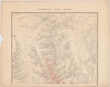
Map - Sandhurst Goldfield 1873, 1873
... Shepherd" Topographic map of Sandhurst gold field, with relief shown by hachures. ...vid=61SLV_INST:SLV&search_scope=slv_local&tab=searchProfile&context=L&docid=alma994975393607636 Map Sandhurst Goldfield 1873 ...Robert Brough Smyth (1830-1889), civil servant and mining engineer, was born on 18 February 1830 near Wallsend, Northumberland, England, son of Edward Smith, mining engineer, and his wife Elizabeth, née Brough. On 14 November 1852 Smyth arrived in Melbourne and went to the gold diggings, where he worked as a carter on the construction of roads at Sawpit Gully. Back in Melbourne, on 7 November 1853 he became a draftsman under the surveyor-general, Andrew Clarke, and soon was acting chief draftsman. Smyth compiled numerous reports and wrote catalogues for exhibitions of minerals and fossils. In November 1869 he superintended the establishment of a museum of economic geology, mineralogy and mining and published in Melbourne The Gold Fields and Mineral Districts of Victoria … Covertly involved in the controversy that led to the disbanding of the Geological Survey in 1869, he became its director on its reinstatement in 1871; he increased its part in the search for and proving of economic mineral and coal deposits. In 1875 he became chief inspector of mines and published the geological reports on John Forrest's Western Australian exploration. On 19 June 1860 Smyth had become honorary secretary to the Board for the Protection of Aborigines and in 1863 became a voting member. Zealous and determined, he assumed the role of chairman, which belonged ex officio to the chief secretary, and wielded great power, including the dubious dismissal of John Green, general inspector of Aborigines in 1861-75 with whom he had earlier collaborated. Smyth's compilation, The Aborigines of Victoria … (1878), arose from his efforts to gather information and artefacts of Victorian Aboriginal cultures at a time when their vestiges were fast disappearing. The work, still valuable though long since superseded, relied heavily upon others such as L. Fison, G. B. Halford, A. Howitt and J. Milligan. Press reports and a petition from officers in the Mining Department accused Smyth of 'tyrannical and overbearing conduct', and in February 1876 a board of inquiry was constituted and heard evidence until April. McCoy defended 'one of the best heads of department he had ever known' but the board found the charges of 'excessive severity … in the main substantiated', and reported that Smyth had been irritable, lacking self-control and over-fastidious, but acknowledged his 'unremitting energy and zealous labours in the public service'. On 4 May Smyth resigned all public offices except his membership of the Aborigines' board. Source: Australian Dictionary of Biography. https://adb.anu.edu.au/biography/smyth-robert-brough-4621Original map printed on paper on canvas; copy of map with original. Title: Sandhurst gold field [cartographic material] / surveyed and compiled under the direction of R. Brough Smyth and Thos. Couchman, Angus Mackay ; additions made to the survey under the same direction by Regd. A.F. Murray, April 1873. "Lithd. by R. Shepherd" Topographic map of Sandhurst gold field, with relief shown by hachures. Shows roads, railways and public buildings. "Note - blocks held under leasing regulations are outlined and numbered in red" Map is also available on State Library Victoria: https://find.slv.vic.gov.au/discovery/fulldisplay?vid=61SLV_INST:SLV&search_scope=slv_local&tab=searchProfile&context=L&docid=alma994975393607636 sandhurst, goldfield, lease holdings, gullies, brough smyth, state library of victoria