Showing 14 items matching "sandy point"
-
 Phillip Island and District Historical Society Inc.
Book, BENNETT, Bruce, Sandy Point : the history of Sandy Point, Western Port, 1999
... Sandy Point : the history of Sandy Point, Western Port...sandy point...Phillip Island and District Historical Society Inc. phillip-island-and-the-bass-coast sandy point history victoria Sandy Point : the history of Sandy Point, Western Port Book BENNETT, Bruce Bruce Bennett ...sandy point, history, victoria -
 Phillip Island and District Historical Society Inc.
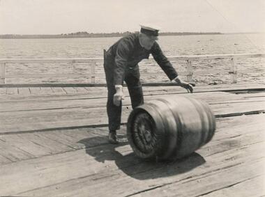
Photograph
... Photograph of Captain James Clark rolling a barrel on Cowes Jetty. Sandy Point in background....Phillip Island and District Historical Society Inc. phillip-island-and-the-bass-coast One of a collection of over 400 photographs in an album commenced in 1960 and presented to the Phillip Island & Westernport Historical Society by the Shire of Phillip Island local history photography photographs captain james clark ferry captain black & white photograph shipping ferry captains cargo cowes jetty john jenner bryant west Photograph of Captain James Clark rolling a barrel on Cowes Jetty. Sandy Point in background. Photograph Bryant West ...One of a collection of over 400 photographs in an album commenced in 1960 and presented to the Phillip Island & Westernport Historical Society by the Shire of Phillip IslandPhotograph of Captain James Clark rolling a barrel on Cowes Jetty. Sandy Point in background.local history, photography, photographs, captain james clark, ferry captain, black & white photograph, shipping, ferry captains, cargo, cowes jetty, john jenner, bryant west -
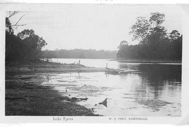 Lakes Entrance Historical Society
Postcard - Lake Tyers Victoria, Vogt, W S, c1916
... Showing heavily timbered banks and a rowing boat pulled up at a sandy point. Lake Tyers Victoria...Showing heavily timbered banks and a rowing boat pulled up at a sandy point. Lake Tyers Victoria Postcard Lake Tyers Victoria Vogt, W S ...Black and white postcard of an arm of Lake Tyers. Showing heavily timbered banks and a rowing boat pulled up at a sandy point. Lake Tyers VictoriaLake Tyerswaterways, boats and boating, vegetation -
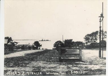 Phillip Island and District Historical Society Inc.
Photograph, 3/10/1920
... HMAS Australia shown in the distant between Cowes and Sandy Point. Part of Cowes Garage also depicted....HMAS Australia shown in the distant between Cowes and Sandy Point. Part of Cowes Garage also depicted. ...One of a collection of over 400 photographs in an album commenced in 1960 and presented to the Historical Society by the Shire of Phillip IslandPhotograph looking north along Thompson Avenue from Chapel Street. HMAS Australia shown in the distant between Cowes and Sandy Point. Part of Cowes Garage also depicted.local history, photography, photographs, film maritime technology, boats, thompson avenue - hmas australia - cowes garage, black & white photograph, cowes, thompson avenue, shipping, hmas australia, cowes garage, john jenner, bryant west -
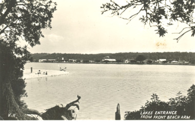
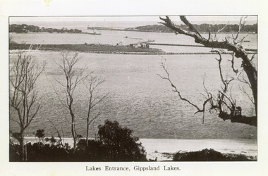 Lakes Entrance Historical Society
Photograph - The Entrance c1922, Lakes Entrance, Gippsland Lakes, 1922c
... It shows the western end of Bullock Island with bathing boxes, rock groynes, and sandy shore beneath Jemmys Point. Lakes Entrance Victoria...It shows the western end of Bullock Island with bathing boxes, rock groynes, and sandy shore beneath Jemmys Point. Lakes Entrance Victoria Lakes Entrance, Gippsland Lakes Photograph The Entrance c1922 ...Black and white copy 9.5 x 15|Black and white copy 12x18Black and white photograph of the entrance and Bullock Island. It shows the western end of Bullock Island with bathing boxes, rock groynes, and sandy shore beneath Jemmys Point. Lakes Entrance VictoriaLakes Entrance, Gippsland Lakesislands, waterways, topography -
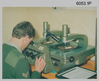 Bendigo Military Museum
Photograph - Army Survey Regiment Map Production Equipment, c1980s, c1990s
... point transfer device in Air Survey Squadron c1980s. Control points were transferred onto the mapping diapositives of aerial photography by drilling their locations into the photographic emulsion. SPR Viv (Hawkins) Doherty in photo .2P, SPR Jeanette Drury-Lane in photo .5P and SGT Sandy...point transfer device in Air Survey Squadron c1980s. Control points were transferred onto the mapping diapositives of aerial photography by drilling their locations into the photographic emulsion. SPR Viv (Hawkins) Doherty in photo .2P, SPR Jeanette Drury-Lane in photo .5P and SGT Sandy ...Photos .1P, .2P, and.4P were most likely taken in the 1980s and photos .3P, .5P to .8P in the c1990s at the Army Survey Regiment, Fortuna, Bendigo. Despite lacking annotation on exact dates, locations and personnel, they are positively identified. CPL Ian Nelson in photo .1P is operating a Wild Pug 4 point transfer device in Air Survey Squadron c1980s. Control points were transferred onto the mapping diapositives of aerial photography by drilling their locations into the photographic emulsion. SPR Viv (Hawkins) Doherty in photo .2P, SPR Jeanette Drury-Lane in photo .5P and SGT Sandy Craig are operating a Wild B8 Stereoplotter coupled to a digital workstation in Air Survey Squadron c1994. Topographic features were extracted with the B8 in 3D and feature coded with attributes, using keyboard, menu, keypad and voice inputs to the computer. The features were stored in the AUTOMAP 2 digital database for subsequent cartographic production and printing. CPL Mick Ellis in photo .3P is operating the Optronix 4040 Scanner/Film Writer in Lithographic Squadron c1990s. In scanning mode, compilation sheets were mounted on the drum and scanned. The resultant raster file was vectorized, feature coded with attributes and stored by cartographic technicians in the AUTOMAP 2 database. In film writing mode, digital cartographic files were output at very high resolution for each print colour on photosensitive film, for subsequent finalisation, platemaking and printing.This is a set of eight photographs of technicians operating map production equipment at the Army Survey Regiment, Bendigo. The photographs were printed on photographic paper and are part of the Army Survey Regiment’s Collection. The photographs were scanned at 300 dpi. Photo negatives were scanned at 2400 dpi. .1) - Photo, colour, c1980s. CPL Ian Nelson operating a Wild Pug 4 point transfer device in Air Survey Squadron. .2) - Photo, colour, c1980s. Wild B8 Aviograph stereoplotter feature extraction, SPR Viv (Hawkins) Doherty in Air Survey Squadron. .3) - Photo, colour, c1990s. CPL Mick Ellis operating the Optronics 4040 Scanner in Lithographic Squadron. .4) - Photo, colour, c1984. AUTOMAP 2 Graphic Edit Workstation, SPR Craig Kellet in Cartographic Squadron. .5) - Photo, colour, c1994. Wild B8 Aviograph stereoplotter feature extraction, SPR Jeanette Drury-Lane in Air Survey Squadron. .6) - Photo, colour, c1994. AUTOMAP 2 Graphic Edit Workstation, L to R: unidentified, SPR Rachel (Stanford) Scott, CPL Chris Wynn in Cartographic Squadron. .7) - Photo, colour, c1994. Wild B8 Aviograph stereoplotter AUTOMAP 2 Graphic Edit Workstation, L to R: unidentified (x2), SGT Sandy Craig in Air Survey Squadron. .8) - Photo, colour, c1994. AUTOMAP 2 Graphic Edit Workstation, L to R: unidentified, SPR Peter Smyth, SPR Frank Savy, SPR Quentin Seecamp, CPL Steve McGuiness in Cartographic Squadron. .1P – no annotations .2P – annotated “Stereoplotter Workstation. The operator has the use of keyboard, menu, keypad and voice for input to the computer. Feedback is given through voice and screen messages.” .3 to .8P – no annotationsroyal australian survey corps, rasvy, army survey regiment, army svy regt, fortuna, air survey, litho, aerotrig, automap 2 -
4th/19th Prince of Wales's Light Horse Regiment Unit History Room
Order of Ceremony, The Royal Australian Amored (sic) Corps the Keeffe Family & Eoghan McDonald Celebrates (sic) the Unveiling of a Commemorative Plaque 16 November 2014, 2014
... point on Whiteheads Creek. The column consisted of seven M3 Medium Tanks and four Universal Carriers. In the case of Corporal McLeod's vehicle, there were seven crewmen rather than the usual five man crew. On arrival at the creek crossing, Captain C.M.I. 'Sandy...point on Whiteheads Creek. The column consisted of seven M3 Medium Tanks and four Universal Carriers. In the case of Corporal McLeod's vehicle, there were seven crewmen rather than the usual five man crew. On arrival at the creek crossing, Captain C.M.I. 'Sandy ...The 13th Australian Armoured Regiment was a Gippsland militia unit that had been called up for full time duty in December 1941 as a traditional light horse regiment. The early months of 1942 had seen the regiment lose its horses, a conversion to a motor regiment and finally to an armoured regiment in May. During this period there were considerable changes in personnel, however the regiment maintained its strong links to Gippsland and its former identity. Between May and November 1942, individual soldiers had become proficient in their trade training and the regiment changed its focus to troop and squadron activities. On 16 November 1942, the unit was located at the Puckapunyal Army Camp. C Squadron's training program involved a night driving exercise where a column of armoured and B vehicles would depart camp at 0245 hours and proceed to a site to the East of Seymour and set up a bivouac between Whiteheads Creek and Highlands Road. Numerous army camps surrounded the Seymour area; and much of the surrounding farm land had been acquired for military purposes. By November 1942 exercises such as C Squadron's were commonplace and had been repeated on numerous occasions since 1939. At 0400 hrs, C Squadron's vehicles reached O'Sullivan's Paddock on the Kobyboyn Road; prior to reaching the Old Telegraph Road the column turned to the North towards a known crossing point on Whiteheads Creek. The column consisted of seven M3 Medium Tanks and four Universal Carriers. In the case of Corporal McLeod's vehicle, there were seven crewmen rather than the usual five man crew. On arrival at the creek crossing, Captain C.M.I. 'Sandy' Pearson dismounted and with the assistance of Sergeant R.J. Ball began to guide individual tanks across the creek. Four tanks had crossed the creek without difficulty when Corporal McLeod's tank, ARN 24652, began its descent. Captain Pearson stated at the Coroner's Inquiry in December 1942, "Whilst climbing out of the ford the vehicle swerved to the left, apparently striking the tree. It was not the portion of the tank (front) that struck the tree. The tank straightened and appeared to be well under control, suddenly the bank on the left collapsed to the extent of 3ft by 12ft by15ft long causing the vehicle to slide into the creek and turn upside down." Captain Pearson and Sergeant Ball were faced with a nightmarish situation: The Grant had come to rest upside down in soft mud, six crew members were unaccounted for, escape hatches could not be opened and the weight of the tank was settling deeper into the water and mud. Compounding the problem was that the location of the tank did not allow for the other tanks to safely conduct a recovery. It was truly the darkest night.Single A4 card. folded, Contains an account of the raising of 13 Armoured Regiment in December 1941and a tank accident during a night creek crossing in which six crewmen were killed, and, Order of Ceremony for plaque unveiling, Guest of Honour LtCol Stuart Cree CO/CI School of Armour13 armored regiment, tank accident, puckapunyal -
 Phillip Island and District Historical Society Inc.
Photograph, Bryant West, Approx. 1925
... Photograph of Sandy Island near Lady Nelson Point about 1925. It has since disappeared beneath the waves....Phillip Island and District Historical Society Inc. phillip-island-and-the-bass-coast One of a collection of over 400 photographs in an album commenced in 1960 and presented to the Phillip Island & Westernport Historical Society by the Shire of Phillip Island local history photography photographs topography island black & white photograph coast line islands sandy island rhyll john jenner bryant west Photograph of Sandy Island near Lady Nelson Point about 1925. It has since disappeared beneath the waves. ...One of a collection of over 400 photographs in an album commenced in 1960 and presented to the Phillip Island & Westernport Historical Society by the Shire of Phillip IslandPhotograph of Sandy Island near Lady Nelson Point about 1925. It has since disappeared beneath the waves.local history, photography, photographs, topography, island, black & white photograph, coast line, islands, sandy island rhyll, john jenner, bryant west -
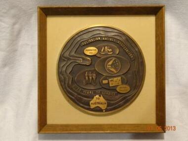 Learmonth and District Historical Society Inc.
Plaque "ANA"100 years service to Australia, Circa 20th century
... CENTENARY PLAQUE AUSTRALIAN NATIVES ASSOCIATION.1871 - 1971.This plaque commemorates the centenary of the Australian Natives Association and depicts some of the achievements brought about by the Association in Australia over a Century.The circular shape symbolizes a continuous line of achievements around a central point or theme.Whithin this shape are three bands of waving and undulating sand textured steps,passing through the map of Australia. these bands signify the rolling sandy plains which are so characteristic of this country .There is a total of seven basic shapes representing the seven states - six of which are overlapping representing the mainland.The six oval shapes depict The ANA.crest Federation 1901.The Made in Australia Council.The Australia Day Council. ...Learmonth and District Historical Society Inc. 326 High Street Learmonth goldfields CENTENARY PLAQUE AUSTRALIAN NATIVES ASSOCIATION.1871 - 1971.This plaque commemorates the centenary of the Australian Natives Association and depicts some of the achievements brought about by the Association in Australia over a Century.The circular shape symbolizes a continuous line of achievements around a central point or theme.Whithin this shape are three bands of waving and undulating sand textured steps,passing through the map of Australia. these bands signify the rolling sandy plains which are so characteristic of this country .There is a total of seven basic shapes representing the seven states - six of which are overlapping representing the mainland.The six oval shapes depict The ANA.crest Federation 1901.The Made in Australia Council.The Australia Day Council. ...CENTENARY PLAQUE AUSTRALIAN NATIVES ASSOCIATION.1871 - 1971.This plaque commemorates the centenary of the Australian Natives Association and depicts some of the achievements brought about by the Association in Australia over a Century.The circular shape symbolizes a continuous line of achievements around a central point or theme.Whithin this shape are three bands of waving and undulating sand textured steps,passing through the map of Australia. these bands signify the rolling sandy plains which are so characteristic of this country .There is a total of seven basic shapes representing the seven states - six of which are overlapping representing the mainland.The six oval shapes depict The ANA.crest Federation 1901.The Made in Australia Council.The Australia Day Council. The Armed Forces and Friendly Society.Made to commemorate 100 years service of ANA to Australia.A rectangular shadow box style frame of brown wood,in which is a round Brass Medallion on a beige background.Around the edge are wavy bands representing rolling sands.At the top are the words AUSTRALIAN NATIVES ASSOCIATION and at the bottom is inscribed 100 YEARS OF SERVICE and on a map of Australia TO AUSTRALIA.There are seven basic oval shapes on which -from the top-is the ANA Crest and the words Federation 1901.then a Boomerang with the stars of the Southern Cross and the words Buy Australian,then a map of Australia on which are standing three figures of Army,Navy,Airforce Personel,then the Australian flag with Jan 26 and Friendly Society.AUSTRALIAN NATIVES ASSOCIATION 100 YEARS OF SERVICE TO AUSTRALIA.ana commemoration plaque. -
Federation University Historical Collection
Report, Grampians Puma
... Sandy mackirdy...mark johnson...john morris...des paulson...feral cat...roses gap...paula odare...gaye beveridge...donald macarthur...karen jeffery...plaster casts...terry rethus...tom schubert...Victoria valley...mt talbot...fox...john spencer...ivan bother...neal bother...evan macklay...harry shrive...bill hower...michael harrsion...norma harrison...ellis tucker...gary middleton...barry henderson...joy potter...les becker...John Ryan...Cam anderson...Richardson...Shirley farrant...Adinsall...max xharles...margaret hurley...linda crawford...don anderson...paddy hynes...barry bell...neal boethe...Mark Johnson...Victoria Point...: An up-dated Report of the Deakin Puma Study Australian Animal Folklore Collection John A Henry John Henry Maurice Hornocker grampians geranium springs puma Felis concor mt bepcha scats US Army Peter Morris hans brunner mt Gambier RAAF Ernst Wieher Ellis Tucker halls gap Peter Dryden Geoff Riddle Snow astbury robert hiatt tom schubert trevor clark dick saligari ted saligari terry zerbst brian warren gary Middleton barry henderson morrie lawson bill hower michael harrison ray kerris robert east terry rethus dougal shilcock garth rees ilka rees harry shrive ellis tucker American Airmen Mascot Billywing range Sandy mackirdy mark johnson john morris des paulson feral cat roses gap paula odare gaye beveridge donald macarthur karen jeffery plaster casts terry rethus tom schubert Victoria valley mt talbot fox john spencer ivan bother neal bother evan macklay harry shrive bill hower michael harrsion norma harrison ellis tucker gary middleton barry henderson joy potter les becker John Ryan Cam anderson Richardson Shirley farrant Adinsall max xharles margaret hurley linda crawford don anderson paddy hynes barry bell neal boethe Mark Johnson Victoria Point David Hamilton Wally Smith mythical myth folklore White A4 pages laser printed pages related to a study conducted on the possibility of a Grampians Puma (Felis concolor) populations. ...The study into the Grampians Puma was undertaken by John A. Henry to settle the question of the existence of a puma population in the mountains. People who believe they have sighted a puma, or have sighted other evidence, were interviewed. The study also looked into records relating to the potential of USA army personal leaving a mascot in the grampians. Also see cat no 14012 - Pumas in the Grampians Mountains: A compelling Case?: An up-dated Report of the Deakin Puma StudyWhite A4 pages laser printed pages related to a study conducted on the possibility of a Grampians Puma (Felis concolor) populations. Australian Animal Foklore Collectionaustralian animal folklore collection, john a henry, john henry, maurice hornocker, grampians, geranium springs, puma, felis concor, mt bepcha, scats, us army, peter morris, hans brunner, mt gambier, raaf, ernst wieher, ellis tucker, halls gap, peter dryden, geoff riddle, snow astbury, robert hiatt, tom schubert, trevor clark, dick saligari, ted saligari, terry zerbst, brian warren, gary middleton, barry henderson, morrie lawson, bill hower, michael harrison, ray kerris, robert east, terry rethus, dougal shilcock, garth rees, ilka rees, harry shrive, ellis tucker, american airmen, mascot, billywing range, sandy mackirdy, mark johnson, john morris, des paulson, feral cat, roses gap, paula odare, gaye beveridge, donald macarthur, karen jeffery, plaster casts, terry rethus, tom schubert, victoria valley, mt talbot, fox, john spencer, ivan bother, neal bother, evan macklay, harry shrive, bill hower, michael harrsion, norma harrison, ellis tucker, gary middleton, barry henderson, joy potter, les becker, john ryan, cam anderson, richardson, shirley farrant, adinsall, max xharles, margaret hurley, linda crawford, don anderson, paddy hynes, barry bell, neal boethe, mark johnson, victoria point, david hamilton, wally smith, mythical, myth, folklore -
 Federation University Historical Collection
Document, Ken Clements, Peterborough Puzzles, 2009, 2009
... sandy bay...dog trap bay...buckley creek...viviennes lookeout...stanhope bay...buttres bay...burnies beach...armstrong creek...flaxman hill...antares rock...lovers nook...crofts bay...clements...worm bay...halladale point...This paper by Ken Clements considers the origin of the term martyr in connection to this location, and where the Aboriginal massacre may have taken place. aborigines bay of martyrs massacre bay massacre hill buckley creek run pioneer pastoralists british traversers settlers peterborough maps tourism history method childers cove barque children murnane bay sandy bay dog trap bay buckley creek viviennes lookeout stanhope bay buttres bay burnies beach armstrong creek flaxman hill antares rock lovers nook crofts bay clements worm bay halladale point the well wold dog cove james irvine monument curdies inlet squirrel creek wallaby creek boggy creek whiskey creek pioneer beach schomberg rock young australia spit crown of thorns newfield bay the grotto london bridge point hesse high cliffs the arch Cape Martyr Little massacre bay Aboriginal Massacre ken clements Thirteen page document by Ken Clements relating to Peterborough, Victoria. ...Massacre Bay is located on Victoria's Great Ocean Road, and is in the centre of the Bay of Martyrs. The bay consists of 20 m high, red limestone bluffs. This paper by Ken Clements considers the origin of the term martyr in connection to this location, and where the Aboriginal massacre may have taken place. Thirteen page document by Ken Clements relating to Peterborough, Victoria. Contents include coastal features, local Aborigines, Bay of Martyrs, Massacre Bay, Massacre Hill, Buckley Creek Run, Pioneer Pastoralists, British Traversers, settlers, Peterborough, Maps, tourism, history method. Photographs by Laurie Moore.aborigines, bay of martyrs, massacre bay, massacre hill, buckley creek run, pioneer pastoralists, british traversers, settlers, peterborough, maps, tourism, history method, childers cove, barque children, murnane bay, sandy bay, dog trap bay, buckley creek, viviennes lookeout, stanhope bay, buttres bay, burnies beach, armstrong creek, flaxman hill, antares rock, lovers nook, crofts bay, clements, worm bay, halladale point, the well, wold dog cove, james irvine monument, curdies inlet, squirrel creek, wallaby creek, boggy creek, whiskey creek, pioneer beach, schomberg rock, young australia, spit, crown of thorns, newfield bay, the grotto, london bridge, point hesse, high cliffs, the arch, cape martyr, little massacre bay, aboriginal massacre, ken clements -
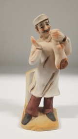 Royal Australian and New Zealand College of Obstetricians & Gynaecologists (RANZCOG)
Sculpture - Porcelain figurine of a doctor holding a baby
... pointing towards the ground. The figure is supported by a plinth behind the right leg, and is standing on a flat, sandy coloured base....pointing towards the ground. The figure is supported by a plinth behind the right leg, and is standing on a flat, sandy coloured base. ...Porcelain bisque figurine of a doctor holding a baby. The doctor is male, with brown hair and a moustache. He is wearing a white surgical gown and cap, with brown trouser cuffs and black shoes visible below the gown. The doctor is holding a baby by its ankles in his left hand, and is holding his right hand with the palm facing towards the baby. The baby is facing the doctor, head pointing towards the ground. The figure is supported by a plinth behind the right leg, and is standing on a flat, sandy coloured base.obstetrics -
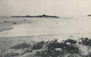
 Lakes Entrance Historical Society
Postcard - Sand hummocks Lakes Entrance Victoria c1940
... Black and white postcard taken from sand hummocks looking across Cunninghame Arm to township, sandy beach known as Play Point shown left centre of image Lakes Entrance Victoria c1940. ...Lakes Entrance Historical Society 4 Marine Parade Lakes Entrance gippsland Waterways Vegetation Township Houses Lakes Entrance from Front Beach Arm and Lakes Entrancee from the South Side Black and white postcard taken from sand hummocks looking across Cunninghame Arm to township, sandy beach known as Play Point shown left centre of image Lakes Entrance Victoria c1940. ...Black and white postcard taken from sand hummocks looking across Cunninghame Arm to township, sandy beach known as Play Point shown left centre of image Lakes Entrance Victoria c1940. Also two other black and white postcards showing similar viewsLakes Entrance from Front Beach Arm and Lakes Entrancee from the South Side waterways, vegetation, township, houses -
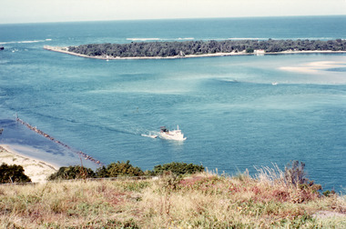 Lakes Entrance Historical Society
Photograph - The Entrance from Jemmys Point Lakes Entrance c1990, Fraser, Ian
... It shows a fishing boat with scallop dredge moving up the lake opposite the artificial entrance, grassy edge of Jemmy's Point in foreground above highway guard fence, rock groyne at entry to North Arm, sandy shallows at entry to Hopetoun Channel, scrub covered hummocks of south shore and Bass Strait in distance. ...It shows a fishing boat with scallop dredge moving up the lake opposite the artificial entrance, grassy edge of Jemmy's Point in foreground above highway guard fence, rock groyne at entry to North Arm, sandy shallows at entry to Hopetoun Channel, scrub covered hummocks of south shore and Bass Strait in distance. ...Colour photograph of the lake. It shows a fishing boat with scallop dredge moving up the lake opposite the artificial entrance, grassy edge of Jemmy's Point in foreground above highway guard fence, rock groyne at entry to North Arm, sandy shallows at entry to Hopetoun Channel, scrub covered hummocks of south shore and Bass Strait in distance. Lakes Entrance Victoriaislands, waterways, topography