Showing 107 items matching "scenic drive"
-
 Mt Dandenong & District Historical Society Inc.
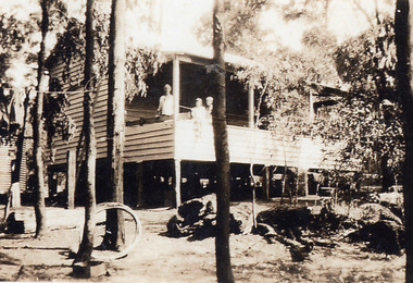
Photograph, Kamanange - Robinson Family Holiday House c1930, Scenic Drive, Kalorama
... Kamanange - Robinson Family Holiday House c1930, Scenic Drive, Kalorama....Farndons Community Hall 42 Falls Road Mt Dandenong yarra-valley-and-the-dandenong-ranges Kamanange Kalorama Robinson View of timber house with a man and two children standing on the balcony Kamanange - Robinson Family Holiday House c1930, Scenic Drive, Kalorama. Photograph ...View of timber house with a man and two children standing on the balconykamanange, kalorama, robinson -
 Clunes Museum
Photograph, 2000
... ...Scenic Drive....1 6 colour photographs of the opening of Wesley College showing the public and the band outside the college .2 two helicopters on Clunes oval - arriving of the dignitaries for the opening .3 Photograph from lookout at Scenic Drive .4 two photographs of Service Street, showing the cars parked for the opening of Wesley College ...Clunes Museum 36 Fraser Street enter building through Collins Place Clunes goldfields Wesley College Scenic Drive Service Street .1 opening /4/00 Kodak Premium, Processing April 2000 .2 Opening Wesley /4/00 .3 High crane Wesley Campus 1999 .4 Opening Wesley 2/4/00 .1 6 colour photographs of the opening of Wesley College showing the public and the band outside the college .2 two helicopters on Clunes oval - arriving of the dignitaries for the opening .3 Photograph from lookout at Scenic Drive .4 two photographs of Service Street, showing the cars parked for the opening of Wesley College Photograph Photograph ....1 6 colour photographs of the opening of Wesley College showing the public and the band outside the college .2 two helicopters on Clunes oval - arriving of the dignitaries for the opening .3 Photograph from lookout at Scenic Drive .4 two photographs of Service Street, showing the cars parked for the opening of Wesley College .1 opening /4/00 Kodak Premium, Processing April 2000 .2 Opening Wesley /4/00 .3 High crane Wesley Campus 1999 .4 Opening Wesley 2/4/00wesley college, scenic drive, service street -
 Port of Echuca
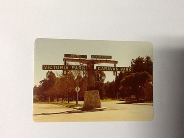
Colour Photograph, Approx.1979
... It is still the primary sporting ground in Echuca, offering AFL football oval, cricket pitch and nets, athletics and entry to the Echuca boat ramp and the natural bush land of the scenic drive. It also houses Echuca Council caravan park. ...Two driveways are shown, to the east "Caravan Park" and to the west , "Victoria Park", "Boat ramp", " Scenic drive"...Two driveways are shown, to the east "Caravan Park" and to the west , "Victoria Park", "Boat ramp", " Scenic drive" Colour Photograph ...In 1869 the Council moved to name this park "Victoria Park. The cricket pitch construction began in 1873 and major improvements to the ground were undertaken in 1881. It is still the primary sporting ground in Echuca, offering AFL football oval, cricket pitch and nets, athletics and entry to the Echuca boat ramp and the natural bush land of the scenic drive. It also houses Echuca Council caravan park. The signage in this photograph is no longer there and the enterance to the caravan park has moved.This area of Echuca has historically been a major recreational area for the town. Being the primary sporting ground since its establishment in 1869., the area has a number of sporting and recreational facilities for the people of Campaspe Shire, from natural bush walks in and along the Murray river to more formal facilities such as AFL football ground, firefighting training area, netball courts, cricket pitch and nets, and grass tennis courts. Colour photograph (post-card size) of directory signs to entrance of Victoria Park, Echuca taken facing north. Two driveways are shown, to the east "Caravan Park" and to the west , "Victoria Park", "Boat ramp", " Scenic drive"Printed in black on the reverse:"this paper manufactured by Kodak"echuca, port of, echuca council caravan park, victoria park, echuca, echuca-tourist attraction -
 Clunes Museum
Postcard - PHOTOGRAPH
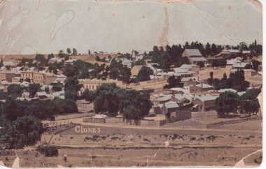
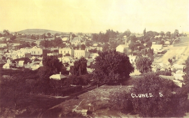
... COLOURED PANORAMIC VIEW OF CLUNES LOOKING SOUTHWARD FROM SCENIC DRIVE...Clunes Museum 36 Fraser Street enter building through Collins Place Clunes goldfields local history photography photographs clunes township COLOURED PANORAMIC VIEW OF CLUNES LOOKING SOUTHWARD FROM SCENIC DRIVE Postcard PHOTOGRAPH ...COLOURED PANORAMIC VIEW OF CLUNES LOOKING SOUTHWARD FROM SCENIC DRIVElocal history, photography, photographs, clunes township -
 Clunes Museum
Photograph, 1911
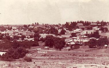
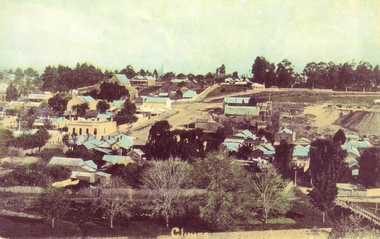
... COPY OF POSTCARD OF TOWNSHIP OF CLUNES 1911, TAKEN FROM SCENIC DRIVE, SHOWING FRASER STRRET BUILDINGS, ST PAUL'S CHURCH ETC....Clunes Museum 36 Fraser Street enter building through Collins Place Clunes goldfields local history document postcard clunes township CLUNES COPY OF POSTCARD OF TOWNSHIP OF CLUNES 1911, TAKEN FROM SCENIC DRIVE, SHOWING FRASER STRRET BUILDINGS, ST PAUL'S CHURCH ETC. ...COPY OF POSTCARD OF TOWNSHIP OF CLUNES 1911, TAKEN FROM SCENIC DRIVE, SHOWING FRASER STRRET BUILDINGS, ST PAUL'S CHURCH ETC.CLUNESlocal history, document, postcard, clunes township -
 Clunes Museum
Photograph
... PHOTOCOPY - CLUNES LANDSCAPE SHOWING CAMP STREET AND CAMP PARADE, CLUB HOTEL, RSL, STATE SAVINGS BANK ETC TAKEN FROM SCENIC DRIVE...Clunes Museum 36 Fraser Street enter building through Collins Place Clunes goldfields local history photography photographs clunes landscape buildings PHOTOCOPY - CLUNES LANDSCAPE SHOWING CAMP STREET AND CAMP PARADE, CLUB HOTEL, RSL, STATE SAVINGS BANK ETC TAKEN FROM SCENIC DRIVE Photograph PHOTOGRAPH ...PHOTOCOPY - CLUNES LANDSCAPE SHOWING CAMP STREET AND CAMP PARADE, CLUB HOTEL, RSL, STATE SAVINGS BANK ETC TAKEN FROM SCENIC DRIVElocal history, photography, photographs, clunes landscape, buildings -
 Clunes Museum
Photograph
... HAND COLOURED POSTCARD PHOTOGRAPH OF CLUNES LANDSCAPE FROM NORTH CLUNES - NOW THE SCENIC DRIVE VIEW OF UNION BANK, ST THOMAS AQUINAS CHURCH AND PRESBYTERY, ETC...Clunes Museum 36 Fraser Street enter building through Collins Place Clunes goldfields local history photography photographs clunes landscape buildings HAND COLOURED POSTCARD PHOTOGRAPH OF CLUNES LANDSCAPE FROM NORTH CLUNES - NOW THE SCENIC DRIVE VIEW OF UNION BANK, ST THOMAS AQUINAS CHURCH AND PRESBYTERY, ETC Photograph PHOTOGRAPH ...HAND COLOURED POSTCARD PHOTOGRAPH OF CLUNES LANDSCAPE FROM NORTH CLUNES - NOW THE SCENIC DRIVE VIEW OF UNION BANK, ST THOMAS AQUINAS CHURCH AND PRESBYTERY, ETClocal history, photography, photographs, clunes landscape, buildings -
 Clunes Museum
Photograph, MONUMENT
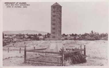
... BLACK AND WHITE POSTCARD OF THE BRICK MONUMENT ON SCENIC DRIVE, SURROUNDED BY WOOD AND WIRE MESH FENCE WITH CAMP PARADE AND MOUNT BECKWORTH IN BACKGROUND. ...BLACK AND WHITE POSTCARD OF THE BRICK MONUMENT ON SCENIC DRIVE, SURROUNDED BY WOOD AND WIRE MESH FENCE WITH CAMP PARADE AND MOUNT BECKWORTH IN BACKGROUND. ...MONUMENT BUILT AND ERECTED ON SITE OF FIRST GOLD DISCOVERY IN VICTORIA 1851. PORT PHILLIP MINE.BLACK AND WHITE POSTCARD OF THE BRICK MONUMENT ON SCENIC DRIVE, SURROUNDED BY WOOD AND WIRE MESH FENCE WITH CAMP PARADE AND MOUNT BECKWORTH IN BACKGROUND. PLAQUE ON CEMENT BASE OF BRICK PILLAR.MONUMENT AT CLUNES. GOLD WAS FIRST DISCOVERED HERE IN VICTORIA 1851.photography, monuments, memorials& mining -
 Clunes Museum
Photograph
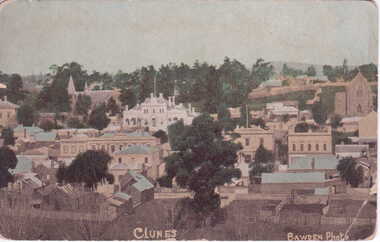
... .1 ORIGINAL POSTCARD - OVERVIEW OF CLUNES - FROM SCENIC DRIVE, SHOWING TOWN HALL, CLUB HOTEL ETC. .2 SEPIA COPY OF ABOVE PRINTED ON PHOTOGRAPHIC PAPER .3 COLOURED COPIES OF ABOVE POSTCARD REPRODUCED BY BAWDEN PHOTO .4 black and white photograph...I will write next week. hope G is better, Bear would like a trip, love from all Kit .3.4 On front of postcards in white printing; Clunes Bawden Photo .1 ORIGINAL POSTCARD - OVERVIEW OF CLUNES - FROM SCENIC DRIVE, SHOWING TOWN HALL, CLUB HOTEL ETC. .2 SEPIA COPY OF ABOVE PRINTED ON PHOTOGRAPHIC PAPER .3 COLOURED COPIES OF ABOVE POSTCARD REPRODUCED BY BAWDEN PHOTO .4 black and white photograph Photograph PHOTOGRAPH ...POSTCARD SENT TO MRS. L. MCLENNAN, QUEENSLAND.1 ORIGINAL POSTCARD - OVERVIEW OF CLUNES - FROM SCENIC DRIVE, SHOWING TOWN HALL, CLUB HOTEL ETC. .2 SEPIA COPY OF ABOVE PRINTED ON PHOTOGRAPHIC PAPER .3 COLOURED COPIES OF ABOVE POSTCARD REPRODUCED BY BAWDEN PHOTO .4 black and white photograph1. On reverse of postcard addressed to; Mrs. L. McLennan, Olive Station, via Marlborough, Rockhampton - hand written message "Dear A., Lot is home have not seen here yet. I will write next week. hope G is better, Bear would like a trip, love from all Kit .3.4 On front of postcards in white printing; Clunes Bawden Photolocal history, document, postcard, clunes township -
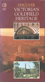 Bendigo Historical Society Inc.
Book - Discover Victoria's Goldfield Heritage
... Includes Ballarat, Bendigo, Castlemaine and Stawell Written by Douglas Stone and Greg Dunnett First published 1993 by See Australia Guides Pty Ltd Printed and bound by Toppan, Hong Kong Includes route maps, city and town maps, town walks, scenic drives and bike rides....Includes Ballarat, Bendigo, Castlemaine and Stawell Written by Douglas Stone and Greg Dunnett First published 1993 by See Australia Guides Pty Ltd Printed and bound by Toppan, Hong Kong Includes route maps, city and town maps, town walks, scenic drives and bike rides. Book Discover Victoria's Goldfield Heritage ...128-page illustrated soft cover book entitled 'Discover Victoria's Goldfield Heritage. Includes Ballarat, Bendigo, Castlemaine and Stawell Written by Douglas Stone and Greg Dunnett First published 1993 by See Australia Guides Pty Ltd Printed and bound by Toppan, Hong Kong Includes route maps, city and town maps, town walks, scenic drives and bike rides.Handwritten in pen PETER RYALL on title page.goldfields, bendigo, ballarat, castlemaine, see australia guides -
Glenelg Shire Council Cultural Collection
Pamphlet - Pamphlets - Portland and surrounds, Victoria, n.d
... Collection of pamphlets, information and maps for seven tourist tours of Portland and district. a. green Tour No. 1 Town of Portland b. pale yellow Tour No.2 Portland Harbour c. blue Tour No. 3 Scenic Drive d. gold Tour No. 4 Cobboboonee Forest e. yellow Tour No.5 Nelson, Glenelg River and caves f. pink Tour No. 6 Bridgewater Bay, Lakes, Blowholes g. orange Tour No. 7 Yambuk Lakes, Mt. ...Glenelg Shire Council Cultural Collection History House Cliff Street Portland great-ocean-road Front: 'VIVIAN' -handwritten, blue biro, top right Collection of pamphlets, information and maps for seven tourist tours of Portland and district. a. green Tour No. 1 Town of Portland b. pale yellow Tour No.2 Portland Harbour c. blue Tour No. 3 Scenic Drive d. gold Tour No. 4 Cobboboonee Forest e. yellow Tour No.5 Nelson, Glenelg River and caves f. pink Tour No. 6 Bridgewater Bay, Lakes, Blowholes g. orange Tour No. 7 Yambuk Lakes, Mt. ...Collection of pamphlets, information and maps for seven tourist tours of Portland and district. a. green Tour No. 1 Town of Portland b. pale yellow Tour No.2 Portland Harbour c. blue Tour No. 3 Scenic Drive d. gold Tour No. 4 Cobboboonee Forest e. yellow Tour No.5 Nelson, Glenelg River and caves f. pink Tour No. 6 Bridgewater Bay, Lakes, Blowholes g. orange Tour No. 7 Yambuk Lakes, Mt. ClayFront: 'VIVIAN' -handwritten, blue biro, top right -
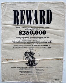 Flagstaff Hill Maritime Museum and Village
Article - Reward Poster - Portuguese Caravel, 1992
... Believed to be a PORTUGUESE CARAVEL, this traveller is thought to be hiding somewhere along the world's most scenic coastal drive- Victoria's Great Ocean Road. ...Believed to be a PORTUGUESE CARAVEL, this traveller is thought to be hiding somewhere along the world's most scenic coastal drive- Victoria's Great Ocean Road. ...The mystery of the Portuguese Caravel, commonly known as the ‘Mahogany Ship’ is today regarded as legend and refers to an ancient wreck that is said to lie beneath the sand between Warrnambool and Port Fairy. Its location is currently unknown, but many people have searched for it through the years since the first reported sighting of an unidentified wreck in 1836. For over a century this mystery has fascinated Australians because the existence of such a vessel could throw light on the earliest phase of exploration of Eastern Australia by Europeans. The interest in the mystery was high enough for the Victorian Government to offer a reward in 1992 which was subsequently withdrawn a year later with no monies being paid.This item is historically significant because of its relationship to an ongoing mystery (the Mahogany Ship) that may throw light on the early exploration of Australia. The offering of a reward, 150+years after the first recorded sighting, by the Victorian Government points to the ongoing fascination with this subject to the Victorian people.A reward poster printed on calico. Even though the poster was created in 1992 it follows the regular structure of a reward poster from earlier times; the word REWARD in large print at the top, the amount $250,000 in bold type and an imagined drawing of the missing Portuguese Caravel.Printed text: REWARD Notice is hereby given that the Government of Victoria is offering a REWARD of $250,000 for the DISCOVERY of an international invader that has eluded authorities for more than 400 years. Believed to be a PORTUGUESE CARAVEL, this traveller is thought to be hiding somewhere along the world's most scenic coastal drive- Victoria's Great Ocean Road. Positive sightings could rewrite the HISTORY OF AUSTRALIA. More than 20 unconfirmed sightings have been reported since 1836. Description: Approx. 26 metres long, 12 metres wide, 20 metres in height, dark brown in colour. BOUNTY HUNTERS AND INTERESTED PARTIES SHOULD APPLY TO: FLAGSTAFF HILL MARITIME MUSEUM, PO BOX 574 WARRNAMBOOL 3280 OR TOURISM MANAGER, DEPARTMENT OF CONSERVATION & ENVIRONMENT, 8TH FLOOR 250 VICTORIA PARADE, EAST MELBOURNE 3002 BY ORDER OF THE VICTORIAN MINISTER FOR TOURISM. Printed image: back view of a Caravel in full sail flagstaff hill maritime museum and village, great ocean road, shipwreck coast, warrnambool, port fairy, portuguese caravel, mahogany ship, reward poster, victorian government -
Federation University Historical Collection
Booklet, Buninyong Heritage Walks and other Interesting Cycle Rides and Scenic Drives, 2008
... Buninyong Heritage Walks and other Interesting Cycle Rides and Scenic Drives Booklet Booklet Neil McCraken Buninyong & District Historical Society ...Blue soft covered book, with maps, plans and photographs relating to Buninyong, Victoria. buninyong, de soza park, buninyong tannery, buninyong railway station, eagle hotel, old buninyong library, hastie's hill, buninyong town hall, hastie's spring, crown hotel, buninyong post office, bowen tree, aborigines, buninyong primary school, buninyong cemetery, gold monument, mount buninyong, lal lal falls -
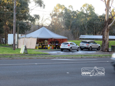 Eltham District Historical Society Inc
Photograph, Liz Pidgeon, Heritage Excursion; Eltham Lower Park Walk and Talk, 1 July 2017, 1 July 2017
... scenic walk. This walk on Saturday 1st July is about 3.5 km in length and will take 2 to 2.5 hours. It will start at 2pm at the Main Road car park at the front of the park. (Melway ref 21 H 10). Newsletter No., 234, June 2017 heritage excursion activities eltham district historical society eltham lower park roadside store flower vendor fleur de feliss tent drive through drive thru Born Digital Heritage Excursion; Eltham Lower Park Walk and Talk, 1 July 2017 Photograph Photograph Liz Pidgeon ...Temporary flower vendor set up in a tent opposite Eltham Lower Park. The flower seller sets up on weekends and offers a convenient drive through service for customers. Goolge maps in February 2021 identified this site as Fleur De Feliss Roadside Store. Heritage Excursion - Saturday 1st July - Eltham Lower Park - Walk and Talk Eltham Lower Park has played an important part in the history of our area since the early days of European settlement when it was used by local residents as an informal racecourse. Prior to that its location at the junction of the Diamond Creek and the Yarra River made it an important meeting place for the Wurundjeri people. The park combines formal elements and sporting facilities with remnant bushland that is of environmental significance. It is home to sporting and horse riding clubs, popular play spaces and the Diamond Valley Miniature Railway, which attracts large numbers of visitors. The park will be the venue for our July excursion which will comprise a walk of about 3.5 km around the park and adjacent areas. Along the way we will discuss the history and natural history of the area. The path along the creek and the river provides a pleasant and scenic walk. This walk on Saturday 1st July is about 3.5 km in length and will take 2 to 2.5 hours. It will start at 2pm at the Main Road car park at the front of the park. (Melway ref 21 H 10). Newsletter No., 234, June 2017 Born Digitalheritage excursion, activities, eltham district historical society, eltham lower park, roadside store, flower vendor, fleur de feliss, tent, drive through, drive thru -
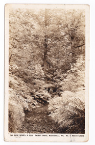 Marysville & District Historical Society
Postcard (item) - Black and white postcard, Rose Stereograph Company, Talbot Drive, Marysville, Vic. No. 5. Beech Grove, 1913-1967
... It is accessible from Lady Talbot Drive which is a 24 kilometer scenic rainforest car journey which passes a number of walks and waterfalls in the Yarra Ranges National Park. ...A postcard in a series produced by the Rose Stereograph Company in Victoria, Australia as a souvenir of Marysville.A black and white photograph taken along Lady Talbot Drive, Marysville, Victoria, of the area known as the Beech Grove. The Beeches Rainforest Walk is a loop that starts at Taggerty Cascades before winding through Myrtle Beech and Mountain Ash woodland and is one of the many walking tracks in and around Marysville. It is accessible from Lady Talbot Drive which is a 24 kilometer scenic rainforest car journey which passes a number of walks and waterfalls in the Yarra Ranges National Park. Lady Talbot Drive is named after Lady Sarah Elizabeth, the wife of Sir Reginald Talbot, who was the Governor of Victoria from 25th April, 1904 to 6th July 1908. This postcard was produced by the Rose Stereograph Company as a souvenir of Marysville.POST CARD The "Rose" Set/ De Luxe A Real Photograph/ Produced in Australia Published by the Rose Stereograph Co./ Armadale, Victoria. This is just to remind you of/ Marysville - I am spending the/ weekend up here & thoroughly/ enjoying it./ Love to all of you L. McIver All best honey + thanks for/ a lovely day E. + P. F.talbot drive, marysville, victoria, beech grove, p. 2310, rose series postcard, postcard, souvenir, beeches rainforest walk, sarah elizabeth talbot, sir reginald talbot, mountain ash, myrtle beech -
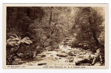 Marysville & District Historical Society
Postcard (item) - Black and white postcard, Rose Stereograph Company, Talbot Drive, Marysville, Vic. No. 12. Taggerty River, 1913-1967
... Lady Talbot Drive is a 24 kilometer scenic rainforest car journey which passes a number of walks and waterfalls in the Yarra Ranges National Park. ...A postcard in a series produced by the Rose Stereograph Company in Victoria, Australia as a souvenir of Marysville.A black and white photograph taken along Lady Talbot Drive, Marysville, Victoria, of the Taggerty River. Lady Talbot Drive is a 24 kilometer scenic rainforest car journey which passes a number of walks and waterfalls in the Yarra Ranges National Park. Lady Talbot Drive is named after Lady Sarah Elizabeth, the wife of Sir Reginald Talbot, who was the Governor of Victoria from 25th April, 1904 to 6th July 1908.REAL PHOTO POST CARD THE "ROSE" SERIES DE LUXE PRODUCED IN AUSTRALIA PUBLISHED BY "THE ROSE STEREOGRAPHS"/ Armadale, Victoria.marysville, victoria, taggerty river, p. 2317, rose series postcard, postcard, souvenir, sir reginald talbot, sarah elizabeth talbot, lady talbot drive -
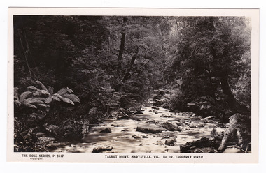 Marysville & District Historical Society
Postcard (item) - Black and white postcard, Rose Stereograph Company, Talbot Drive, Marysville, Vic. No. 12. Taggerty River, 1913-1967
... Lady Talbot Drive a 24 kilometer scenic rainforest car journey which passes a number of walks and waterfalls in the Yarra Ranges National Park. ...A postcard in a series produced by the Rose Stereograph Company in Victoria, Australia as a souvenir of Marysville.A black and white photograph taken along Lady Talbot Drive, Marysville, Victoria, of the Taggerty River. Lady Talbot Drive a 24 kilometer scenic rainforest car journey which passes a number of walks and waterfalls in the Yarra Ranges National Park. Lady Talbot Drive is named after Lady Sarah Elizabeth, the wife of Sir Reginald Talbot, who was the Governor of Victoria from 25th April, 1904 to 6th July 1908.POST CARD The "Rose" Series/ De Luxe A Real Photograph/ Produced in Australia Published by the Rose Stereograph Co.,/ Armadale, Victoria.marysville, victoria, taggerty river, p. 2317, rose series postcard, postcard, souvenir, lady talbot drive, sir reginald talbot, sarah elizabeth talbot -
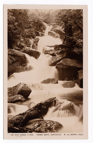 Marysville & District Historical Society
Postcard (item) - Black and white postcard, Rose Stereograph Company, Talbot Drive, Marysville. No. 10. Keppel Falls, 1913-1967
... Lady Talbot Drive is a 24 kilometer scenic rainforest car journey which passes a number of walks and waterfalls in the Yarra Ranges National Park. ...A postcard in a series produced by the Rose Stereograph Company in Victoria, Australia as a souvenir of Marysville.A black and white photograph taken along Lady Talbot Drive, Marysville, Victoria, of Keppel Falls. Keppel Falls are named after the Keppel Family who were one of Marysville's earliest pioneering families. Lady Talbot Drive is a 24 kilometer scenic rainforest car journey which passes a number of walks and waterfalls in the Yarra Ranges National Park. Lady Talbot Drive is named after Lady Sarah Elizabeth, the wife of Sir Reginald Talbot, who was the Governor of Victoria from 25th April, 1904 to 6th July 1908.POST CARD REAL PHOTO THE "ROSE" SERIES DE LUXE PRODUCED IN AUSTRALIA Published by the Rose Stereograph Co.,/ Armadale, Victoria.marysville, keppel falls, waterfalls, postcard, p. 2315, rose series postcard, souvenir, lady talbot drive, sir reginald talbot, sarah elizabeth talbot, keppel family, ] -
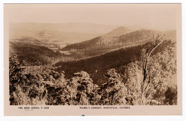 Marysville & District Historical Society
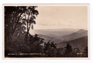
Postcard (item) - Black and white postcard, Rose Stereograph Company, Nichol's Lookout, Marysville, Victoria, 1913-1967
... Today this sealed mountain road is a popular scenic drive between Marysville and Warburton. nicol's lookout lookout marysville victoria p. 2324 rose series postcard postcard souvenir yarra track mining wood's point POST CARD The "Rose" Series/ De Luxe A Real Photograph/ Produced in Australia Published by the Rose Stereograph Co.,/ Armadale, Victoria. ...A postcard in a series produced by the Rose Stereograph Company in Victoria, Australia as a souvenir of Marysville.A black and white photograph of the view of the surrounding hills from Nichol's Lookout which is on the Marysville-Wood's Point road near Marysville in Victoria. The Marysville-Woods Point Road was originally part of the Yarra Track, constructed in the early 1860s to provide access between Healesville and the Woods Point Goldfields. Despite the steep terrain and engineering difficulties, the Yarra Track soon became a busy route used by pack horses, horse-drawn drays, and wagons. Today this sealed mountain road is a popular scenic drive between Marysville and Warburton.POST CARD The "Rose" Series/ De Luxe A Real Photograph/ Produced in Australia Published by the Rose Stereograph Co.,/ Armadale, Victoria. "The Falls"/ Marysville/ Monday Dear Mrs Wilson. Just a line to let you know/ I'm here by Dr's advice. He advised me/ to get extended leave. I'm suffering from/ blood pressure so have to go slow-no/ walking-Ugh-a bitter pill to swallow/ in these glorious surroundings. However/ I'm feeling much better and hope on my/ return (Saturday) to be able to resume duty/ I trust you and yours are well, Your loving/ friend A Butler. Quite/ an imposing/ hotel now/ stands at/ Keppel's/ Corner./ A.B.nicol's lookout, lookout, marysville, victoria, p. 2324, rose series postcard, postcard, souvenir, yarra track, mining, wood's point -
 Marysville & District Historical Society
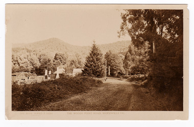
Postcard (item) - Black and white postcard, Rose Stereograph Company, The Wood's Point Road, Marysville, Vic, 1913-1967
... Today this sealed mountain road is a popular scenic drive between Marysville and Warburton. wood's point road marysville-wood's point road marysville victoria p. 10201 rose series postcard postcard souvenir yarra track mining wood's point warburton POST CARD REAL PHOTO THE "ROSE" SERIES DE LUXE PRODUCED IN AUSTRALIA Published by "The Rose Stereographer"/ Sydney and Melbourne. ...A postcard in a series produced by the Rose Stereograph Company in Victoria, Australia as a souvenir of Marysville.A black and white photograph of the Wood's Point Road in Marysville , Victoria. This is now known as the Marysville-Wood's Point Road. The Marysville-Woods Point Road was originally part of the Yarra Track, constructed in the early 1860s to provide access between Healesville and the Woods Point Goldfields. Despite the steep terrain and engineering difficulties, the Yarra Track soon became a busy route used by pack horses, horse-drawn drays, and wagons. Today this sealed mountain road is a popular scenic drive between Marysville and Warburton.POST CARD REAL PHOTO THE "ROSE" SERIES DE LUXE PRODUCED IN AUSTRALIA Published by "The Rose Stereographer"/ Sydney and Melbourne.wood's point road, marysville-wood's point road, marysville, victoria, p. 10201, rose series postcard, postcard, souvenir, yarra track, mining, wood's point, warburton -
 Marysville & District Historical Society
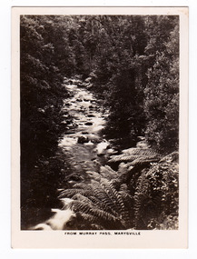
Photograph (item) - Black and white photograph, Rose Stereograph Company, From Murray Pass, Marysville, 1913-1967
... Lady Talbot Drive a 24 kilometer scenic rainforest car journey which passes a number of walks and waterfalls in the Yarra Ranges National Park. ...An early black and white photograph of the Taggerty River from Murray Pass near Marysville, Victoria.An early black and white photograph of the Taggerty River from Murray Pass near Marysville, Victoria. Murray Pass is off the Lady Talbot Drive. Lady Talbot Drive a 24 kilometer scenic rainforest car journey which passes a number of walks and waterfalls in the Yarra Ranges National Park. Lady Talbot Drive is named after Lady Sarah Elizabeth, the wife of Sir Reginald Talbot, who was the Governor of Victoria from 25th April, 1904 to 6th July 1908.The photograph was also used to produce the Rose Series postcard P. 2309.marysville, victoria, photograph, taggerty river, murray pass, lady talbot forest drive, p. 2309, rose series postcard, souvenir, rose stereograph company, sir reginald talbot, lady sarah elizabeth talbot -
 Marysville & District Historical Society
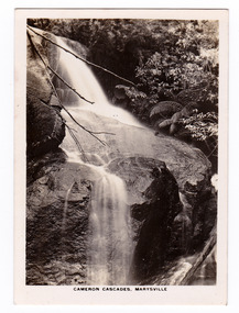
Photograph (item) - Black and white photograph, Rose Stereograph Company, Cameron Cascades, Marysville, 1913-1967
... Lady Talbot Drive a 24 kilometer scenic rainforest car journey which passes a number of walks and waterfalls in the Yarra Ranges National Park. ...An early black and white photograph of the Cameron Cascades near Marysville, Victoria.An early black and white photograph of the Cameron Cascades near Marysville, Victoria. The Cameron Cascades are off the Lady Talbot Drive. Lady Talbot Drive a 24 kilometer scenic rainforest car journey which passes a number of walks and waterfalls in the Yarra Ranges National Park. Lady Talbot Drive is named after Lady Sarah Elizabeth, the wife of Sir Reginald Talbot, who was the Governor of Victoria from 25th April, 1904 to 6th July 1908. The photograph was also used to produce the Rose Series postcard P. 2313.marysville, victoria, photograph, cameron cascades, waterfalls, cameron cascades track, lady talbot forest drive, p. 2313, rose series postcard, souvenir, rose stereograph company, sir reginald talbot, lady sarah elizabeth talbot -
 Marysville & District Historical Society
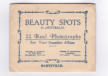
Photograph (item) - Black and white photographs, Rose Stereograph Company, Beauty Spots In Australia-Marysville, 1913-1967
... scenic attractions taken in and around Marysville in Victoria. The photographs were used for a series of photographs and postcards published by the Rose Stereograph Company in Armadale, Victoria. keppel falls (image 1) cumberland falls (image 2) track to cora lynn falls (image 3) nichol's lookout (image 4) cameron cascades (image 5) stevenson falls (image 6) taggerty river (image 7) main street (image 8) taggerty river (image 9) talbot drive (image 10) cora lynn falls (image 11) taggerty river (image 12) rose series postcard rose stereograph company souvenir 12 Real Photographs/ For Your Snapshot Album PRODUCED IN AUSTRALIA/ BY The Rose/ Stereograph Company PRINTERS & PHOTOGRAPHIC/ PUBLISHERS/ Armadale, Victoria An envelope with 12 black and white photographs of scenic attractions taken in and around Marysville in Victoria. ...An envelope with 12 black and white photographs of scenic attractions taken in and around Marysville in Victoria. An envelope with 12 black and white photographs of scenic attractions taken in and around Marysville in Victoria. The photographs were used for a series of photographs and postcards published by the Rose Stereograph Company in Armadale, Victoria.12 Real Photographs/ For Your Snapshot Album PRODUCED IN AUSTRALIA/ BY The Rose/ Stereograph Company PRINTERS & PHOTOGRAPHIC/ PUBLISHERS/ Armadale, Victoriakeppel falls (image 1), cumberland falls (image 2), track to cora lynn falls (image 3), nichol's lookout (image 4), cameron cascades (image 5), stevenson falls (image 6), taggerty river (image 7), main street (image 8), taggerty river (image 9), talbot drive (image 10), cora lynn falls (image 11), taggerty river (image 12), rose series postcard, rose stereograph company, souvenir -
 Marysville & District Historical Society
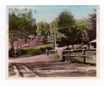
Photograph (item) - Colour tinted photograph, Valentine Publishing Co. Pty. Ltd, The Road to Cumberland Valley, Marysville. No. 1, 1923-1963
... Today this sealed mountain road is a popular scenic drive between Marysville and Warburton. ...An early colour tinted photograph of the intersection of the Buxton Marysville Road and the Marysville-Wood's Point Road.An early photograph of the Buxton Marysville Road and the Marysville-Wood's Point Road intersection. The Marysville-Buxton Road joins the Maroondah Highway which leads to Alexandra. The Marysville-Woods Point Road was originally part of the Yarra Track, constructed in the early 1860s to provide access between Healesville and the Woods Point Goldfields. Despite the steep terrain and engineering difficulties, the Yarra Track soon became a busy route used by pack horses, horse-drawn drays, and wagons. Today this sealed mountain road is a popular scenic drive between Marysville and Warburton. On the right of the photograph can be seen 'The Crossways Hotel' which is circa 1920 and one of the oldest buildings still standing in Marysville. 'The Crossways Hotel' survived the 2009 Black Saturday bushfires, through the efforts of the owner using buckets of water from the nearby Steavenson River. In the background can be seen the Poontawan Guest House which later became the Marysville Chalet Guest House which was on the site of the original Steavenson's Hotel. That guest house no longer exists and the Christ Church stands on the land where the guest house once stood. This photograph was published by the Valentine Publishing Co Pty. Ltd as a souvenir of Marysville.marysville, victoria, marysville chalet guest house, crossways hotel, christ church marysville, poontawan guest house, steavenson's hotel, valentine publishing co, souvenir, yarra track, wood's point road, mining, buxton-marysville road, marysville-wood's point road, maroondah highway, alexandra -
 Marysville & District Historical Society
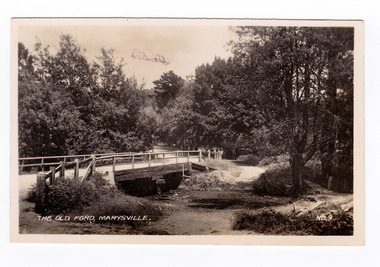
Photograph (item) - Black and white photograph, Valentine Publishing Co. Pty. Ltd, The Old Ford, Marysville No.9, 1923-1963
... Today this sealed mountain road is a popular scenic drive between Marysville and Warburton. ...An early black and white photograph of the old ford in Marysville, Victoria.An early photograph of the bridge at the end of the main street in Marysville which is near the Buxton-Marysville Road and the Marysville-Wood's Point Road intersection. The Marysville-Buxton Road joins the Maroondah Highway which leads to Alexandra. The Marysville-Woods Point Road was originally part of the Yarra Track, constructed in the early 1860s to provide access between Healesville and the Woods Point Goldfields. Despite the steep terrain and engineering difficulties, the Yarra Track soon became a busy route used by pack horses, horse-drawn drays, and wagons. Today this sealed mountain road is a popular scenic drive between Marysville and Warburton. This photograph was published by the Valentine Publishing Co Pty. Ltd as a souvenir of Marysville.marysville, victoria, valentine publishing co, souvenir, buxton-marysville road, marysville-wood's point road, maroondah highway, alexandra, yarra track, mining -
 Marysville & District Historical Society
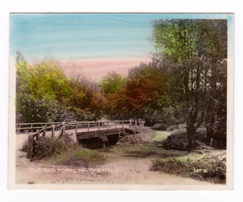
Photograph (item) - Colour tinted photograph, Valentine Publishing Co. Pty. Ltd, The Old Ford, Marysville No.9, 1923-1963
... Today this sealed mountain road is a popular scenic drive between Marysville and Warburton. ...An early colour tinted photograph of the old ford in Marysville, Victoria. This photograph was published by the Valentine Publishing Co Pty. Ltd. as a souvenir of Marysville.An early photograph of the bridge at the end of the main street in Marysville which is near the Buxton-Marysville Road and the Marysville-Wood's Point Road intersection. The Marysville-Buxton Road joins the Maroondah Highway which leads to Alexandra. The Marysville-Woods Point Road was originally part of the Yarra Track, constructed in the early 1860s to provide access between Healesville and the Woods Point Goldfields. Despite the steep terrain and engineering difficulties, the Yarra Track soon became a busy route used by pack horses, horse-drawn drays, and wagons. Today this sealed mountain road is a popular scenic drive between Marysville and Warburton. This photograph was published by the Valentine Publishing Co Pty. Ltd as a souvenir of Marysville.marysville, victoria, valentine publishing co, souvenir, buxton-marysville road, marysville-wood's point road, maroondah highway, alexandra, yarra track, mining -
 Marysville & District Historical Society
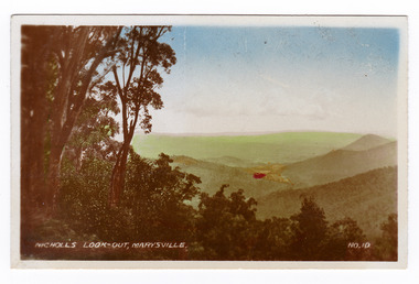
Photograph (item) - Colour tinted photograph, Valentine Publishing Co. Pty. Ltd, Nicoll's Lookout, Marysville No.10, 1923-1963
... Today this sealed mountain road is a popular scenic drive between Marysville and Warburton. ...An early colour tinted photograph of Nicholl's Look-out near Marysville in Victoria. This photograph was published by the Valentine Publishing Co Pty. Ltd. as a souvenir of Marysville.An early colour tinted photograph of Nicholl's Look-out near Marysville in Victoria. This lookout is situated on the Marysville-Wood's Point Road. The Marysville-Woods Point Road was originally part of the Yarra Track, constructed in the early 1860s to provide access between Healesville and the Woods Point Goldfields. Despite the steep terrain and engineering difficulties, the Yarra Track soon became a busy route used by pack horses, horse-drawn drays, and wagons. Today this sealed mountain road is a popular scenic drive between Marysville and Warburton. This photograph was published by the Valentine Publishing Co Pty. Ltd. as a souvenir of Marysville.marysville, victoria, valentine publishing co, souvenir, nicholl's look-out, mining, yarra track -
 Marysville & District Historical Society
Photograph (item) - Black and white photograph, Valentine Publishing Co. Pty. Ltd, Nicoll's Lookout, Marysville No.10, 1923-1963
... Today this sealed mountain road is a popular scenic drive between Marysville and Warburton. ...An early black and white photograph of Nicholl's Look-out near Marysville in Victoria.An early black and white photograph of Nicholl's Look-out near Marysville in Victoria. This lookout is situated on the Marysville-Wood's Point Road. The Marysville-Woods Point Road was originally part of the Yarra Track, constructed in the early 1860s to provide access between Healesville and the Woods Point Goldfields. Despite the steep terrain and engineering difficulties, the Yarra Track soon became a busy route used by pack horses, horse-drawn drays, and wagons. Today this sealed mountain road is a popular scenic drive between Marysville and Warburton. This photograph was published by the Valentine Publishing Co Pty. Ltd. as a souvenir of Marysville.marysville, victoria, valentine publishing co, souvenir, nicholl's look-out, mining, yarra track -
 Marysville & District Historical Society
Postcard (item) - Black and white postcard, Rose Stereograph Company, At Murray Pass, Marysville, 1913-1967
... Lady Talbot Drive a 24 kilometer scenic rainforest car journey which passes a number of walks and waterfalls in the Yarra Ranges National Park. ...A postcard in a series produced by the Rose Stereograph Company in Victoria, Australia as a souvenir of Marysville.An early black and white photograph of the Taggerty River from Murray Pass near Marysville, Victoria. Murray Pass is located on the Lady Talbot Drive. Lady Talbot Drive a 24 kilometer scenic rainforest car journey which passes a number of walks and waterfalls in the Yarra Ranges National Park. Lady Talbot Drive is named after Lady Sarah Elizabeth, the wife of Sir Reginald Talbot, who was the Governor of Victoria from 25th April, 1904 to 6th July 1908. This postcard was produced by the Rose Stereograph Company as a souvenir of Marysville.SOUTHERN CROSS SERIES 2309/ COPYRIGHT/ AT MURRAY PASS, MARYSVILLE, VIC. POST CARD. Correspondence Addressmarysville, victoria, photograph, taggerty river, murray pass, lady talbot forest drive, southern cross series, 2309, postcard, souvenir, lady talbot drive, sir reginald talbot, sarah elizabeth talbot -
 Marysville & District Historical Society
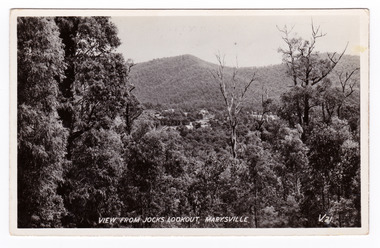
Postcard (item) - Black and white postcard, Valentine Publishing Co. Pty. Ltd, View From Jock's Lookout, Marysville. V. 21, 1923-1963
... Today this sealed mountain road is a popular scenic drive between Marysville and Warburton. ...An early black and white photograph of the view from Jock's Lookout of Marysville in Victoria. An early black and white photograph of the view from Jock's Lookout of Marysville in Victoria. Jock's Lookout is situated on the Marysville-Wood's Point Road. The Marysville-Woods Point Road was originally part of the Yarra Track, constructed in the early 1860s to provide access between Healesville and the Woods Point Goldfields. Despite the steep terrain and engineering difficulties, the Yarra Track soon became a busy route used by pack horses, horse-drawn drays, and wagons. Today this sealed mountain road is a popular scenic drive between Marysville and Warburton. This postcard was published by the Valentine Publishing Co. Pty. Ltd. as a souvenir of Marysville.VALENTINE'S/ POST CARD/ A GENUINE PHOTOGRAPHjock's lookout, marysville, victoria, postcard, valentine publishing co, souvenir, marysville-wood's point road, yarra track, mining, warburton