Showing 46 items matching "scrub hill"
-
 Ballarat Heritage Services
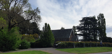
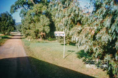
Photograph, Scrub Hill Church, Newlyn, 15/10/2024
... Scrub Hill Church, Newlyn...Scrub Hill...Colour photograph of the Scrub Hill Chuech, a19th-century Bluestone Church at Newlyn, Victoria...Ballarat Heritage Services PO Box 2209 Bakery Hill Post Office goldfields Scrub Hill Church Newlyn Colour photograph of the Scrub Hill Chuech, a19th-century Bluestone Church at Newlyn, Victoria Scrub Hill Church, Newlyn Photograph ...Colour photograph of the Scrub Hill Chuech, a19th-century Bluestone Church at Newlyn, Victoriascrub hill, church, newlyn -
 Uniting Church Archives - Synod of Victoria
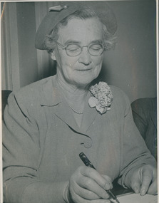
photograph, Undated c.1969
... Scrub Hill, Presbyterian, Mrs J S Bacon...Scrub Hill Presbyterian/Uniting Church was in existence from 1869 to 1994. ...Mrs J S Bacon invited to and photographed at Scrub Hill Presbyterian....Scrub Hill, Presbyterian, Mrs J S Bacon Mrs J S Bacon invited to and photographed at Scrub Hill Presbyterian. ...Scrub Hill Presbyterian/Uniting Church was in existence from 1869 to 1994. This photograph was possibly taken at a centenary event. For further information see "Scrub Hill Church: a pastoral history 1869 - 1994" by Katrine Anderson Kelly, published Ballarat Victoria c.1994.B & W waist length photograph of Mrs J S Baxon seated at a table, signing a book.Mrs J S Bacon invited to and photographed at Scrub Hill Presbyterian.scrub hill, presbyterian, mrs j s bacon -
 Clunes Museum
Book, KATRINE ANDERSON KELLY, SCRUB HILL CHURCH - A PASTORAL HISTORY, 1994
... SCRUB HILL CHURCH - A PASTORAL HISTORY...THIS BOOK IS TO COMMEMORATE THE BUILDING OF THE PRESBYTERIAN CHURCH AT SCRUB HILL EXACTLY 125 YEARS AGO IN APRIL 1869....Clunes Museum 36 Fraser Street enter building through Collins Place Clunes goldfields THIS BOOK IS TO COMMEMORATE THE BUILDING OF THE PRESBYTERIAN CHURCH AT SCRUB HILL EXACTLY 125 YEARS AGO IN APRIL 1869. book churches presbyterian THE AIM OF THIS BOOK IS TO COMMEMORATE THE BUILDING OF THE PRESBYTERIAN CHURCH AT SCRUB HILL... ...THE AIM OF THIS BOOK IS TO COMMEMORATE THE BUILDING OF THE PRESBYTERIAN CHURCH AT SCRUB HILL...A SOFT COVER BOOK, THE FRONT COVER IS A BLACK AND WHITE PASTORAL SCENE WITH AN INSET IMAGE IN BLACK AND WHITE OF A GROUP OF PEOPLE CONGREGATING AT THE FRONT OF THE CHURCH. THE BACK COVER SHOWS BLACK AND WHITE PHOTOS OF A SUNDAY SCHOOL ON PARK LAKE, CRESWICK, C 1925, BELOW ARE THE CHILDREN FROM A SUNDAY SCHOOL PLAY 1979THE AIM OF THIS BOOK IS TO COMMEMORATE THE BUILDING OF THE PRESBYTERIAN CHURCH AT SCRUB HILL...book, churches, presbyterian -
 Uniting Church Archives - Synod of Victoria
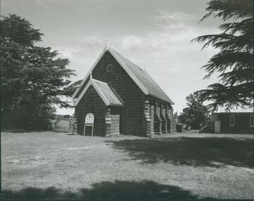
Photograph, undated
... Scrub Hill Uniting Church, Presbyterian, Henry Richards Casselli...B & W exterior view of the Scrub Hill Uniting (formerly Presbyterian) Church. ...The church is now operated as a wedding/event venue. Scrub Hill Uniting Church, Presbyterian, Henry Richards Casselli B & W exterior view of the Scrub Hill Uniting (formerly Presbyterian) Church. ...The bluestone church was designed by Ballarat architect Henry Richards Casselli, and constructed at a cost of 730 pounds. The church was opened on 18 April 1869. The Sunday School Hall was built c.1879. The church was closed in April 2015, and was subsequently sold. The church is now operated as a wedding/event venue.B & W exterior view of the Scrub Hill Uniting (formerly Presbyterian) Church. The image shows a bluestone church with porch and vestry.scrub hill uniting church, presbyterian, henry richards casselli -
Federation University Historical Collection
Booklet, Tippett Grigg Reunion, 1981, c1981
... ...scrub hill...The reunion was held at Scrub Hill, near Ballarat, on 21 and 22 March 1981. ...The reunion was held at Scrub Hill, near Ballarat, on 21 and 22 March 1981. tippett family reunion scrub hill trethowan grigg ronaldson and tippett newlyn dean newlyn stud family history genealogy Self published family reunion book with soft blue cover. ...The reunion was held at Scrub Hill, near Ballarat, on 21 and 22 March 1981. Self published family reunion book with soft blue cover. Includes a Tippett family tree, biographies on John Trewheela Tippett and Elizabeth Ann Grigg, obituaries, Ronaldson and Tippett, tippett, family reunion, scrub hill, trethowan, grigg, ronaldson and tippett, newlyn, dean, newlyn stud, family history, genealogy -
Federation University Historical Collection
Report, Cultural Landscapes Study of Creswick Goldfields Area for Australian Hertiage Commission
... ...scrub hill...Barker Library (top floor) Mount Helen goldfields goldfields of victoria goldfields tourism marketing tourism creswick creswick goldfields allendale broomfield rocklyn bullengarook mollongghip dean scrub hill clarkes hill creswick railway station creswick school of forestry sawpit gully oak gully creswick cemetery kingston creswick avenue of honour kerrins bridge berry deep leads mine system australasian mine site creswick alluvial workings calembeen park ascot anderson's mill smeaton hepburn lagoon White bound report with clear cover Cultural Landscapes Study of Creswick Goldfields Area for Australian Hertiage Commission Report Chris McConville Chris Olver ...White bound report with clear covergoldfields of victoria, goldfields tourism, marketing, tourism, creswick, creswick goldfields, allendale, broomfield, rocklyn, bullengarook, mollongghip, dean, scrub hill, clarkes hill, creswick railway station, creswick school of forestry, sawpit gully, oak gully, creswick cemetery, kingston, creswick avenue of honour, kerrins bridge, berry deep leads mine system, australasian mine site, creswick alluvial workings, calembeen park, ascot, anderson's mill, smeaton, hepburn lagoon -
 Stawell Historical Society Inc
Photograph, Girl Guides in bush setting
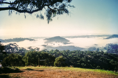
... Guides and leaders outdoors in front of scrub covered hill....Stawell Historical Society Inc 46 Longfield St Stawell grampians Guides Guides and leaders outdoors in front of scrub covered hill. Girl Guides in bush setting Photograph ...Guides and leaders outdoors in front of scrub covered hill.guides -
 Bendigo Military Museum
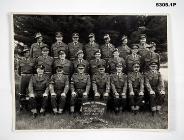
Photograph - PHOTOGRAPHS of AUSTRALIAN SOLDIERS, 38 Bn, c1950-1960
... On rear is written, Scrub Hill, Puckapunyal. 20 Oct 1957. Stamped - photo studio K. ...On rear is written, Scrub Hill, Puckapunyal. 20 Oct 1957. Stamped - photo studio K. ...38 Bn was raised in Bendigo in 1916. Post WW2 it was the CMF unit until 1962. The Mollison Street Drill hall was first used in Jan 1916.1. Group Portrait of OFFICER AND SENIOR NCO'S ON AN INSTRUCTORS COURSE. The course is titled " School of Infantry 10/55 CMF (All Arms) CW Instructors Course 3 Oct - 14 Oct 55. 2. Group Portrait of OFFICER AND SENIOR NCO'S . 3 rows of men in battle dress & berets. They are in front of Army tents. 3. Group Portrait of OFFICER AND SENIOR NCO'S in front of 38 Bn banner. They are all wearing "Battle dress Ceremonial" . Medals are being worn.1. On rear is stamped 3 Oct 1955 (missing data) Seymour, Vic. 2. On rear is written, Scrub Hill, Puckapunyal. 20 Oct 1957. Stamped - photo studio K. Milvain (?) is 30 Emily St, Seymour, Vic. 3. On rear is written " Freedom of City"- "Honorary Colonel" .photographs, 38 bn, puckapunyal -
 Bendigo Historical Society Inc.
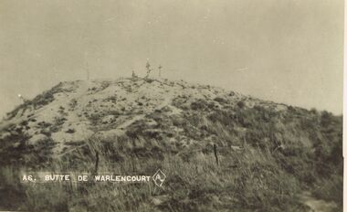
Postcard - ACC LOCK COLLECTION : BUTTE DE WARLENCOURT - POSTCARD, 1914-1918
... Postcard, WW1, B&W image of Butte de Warlencourt. Sand and scrub covered hill with 3 crosses and a loan figure on the summit. ...History House 11 Mackenzie Street Bendigo goldfields POSTCARD WW1 Butte de Warlencourt France Postcard, WW1, B&W image of Butte de Warlencourt. Sand and scrub covered hill with 3 crosses and a loan figure on the summit. ...Postcard, WW1, B&W image of Butte de Warlencourt. Sand and scrub covered hill with 3 crosses and a loan figure on the summit. Wire fence in the foreground. One copy A6postcard, ww1, butte de warlencourt, france -
 Lakes Entrance Historical Society
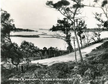
Postcard - Princes Highway at Jemmys Point. Lakes Entrance Victoria, 1930c
... It shows the road winding around the hill between the scrub covered hill and the post and rail guard fence, Bullock Island and rock groynes in the lake also entrance in distance. ...It shows the road winding around the hill between the scrub covered hill and the post and rail guard fence, Bullock Island and rock groynes in the lake also entrance in distance. ...Also faded copy identical imageBlack and white small format postcard of the Princes Highway at Jemmys Point. It shows the road winding around the hill between the scrub covered hill and the post and rail guard fence, Bullock Island and rock groynes in the lake also entrance in distance. Lakes Entrance VictoriaPrinces Highway, Lakes Entranceislands, fences, roads and streets -
 Lakes Entrance Historical Society
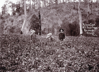
Photograph - Bertha, Gladys and Arthur Falk c1909, Arthur Cooper
... In the background is a scrub covered steep hill showing saplings remaining after clearing, Kalimna West Victoria...In the background is a scrub covered steep hill showing saplings remaining after clearing, Kalimna West Victoria Photograph Bertha, Gladys and Arthur Falk c1909 Arthur Cooper ...Black and white photograph of Bertha aged 10 and Gladys aged 16 and Arthur Falk aged 12 standing in their father's potato crop. In the background is a scrub covered steep hill showing saplings remaining after clearing, Kalimna West Victoriagenealogy, agriculture -
 Eltham District Historical Society Inc
Photograph, "Pindarri" - John Serle, 1968, 1971
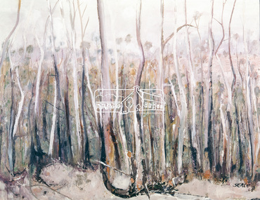
... hills to the Yarra... The timber in general is gum, oak and Banksia, the two later are small, the gum two to four feet of diameter and from then to thirty feet high; on some of the low ground somewhat larger. The forest was open with little scrub...hills to the Yarra... The timber in general is gum, oak and Banksia, the two later are small, the gum two to four feet of diameter and from then to thirty feet high; on some of the low ground somewhat larger. The forest was open with little scrub ...Pindarri was the name of the property on which artist John Serle lived on Pindari Road, St. Andrews. Colour painting reproduced on page 11 of "Pioneers & Painters: One hundred years of Eltham and its Shire" by Alan Marshall (1971). This chapter 1 "In the beginning" gives a physical description of the area: "Thick forest covered all the higher mountain ranges .. These areas were all heavily timbered, associated grasslands and eucalyptus extending from the thick forest country across undulating hills to the Yarra... The timber in general is gum, oak and Banksia, the two later are small, the gum two to four feet of diameter and from then to thirty feet high; on some of the low ground somewhat larger. The forest was open with little scrub..." The artist John Serle (born 1928) was the first local artist to become a councilor for the Shire of Eltham. He also worked for the Shire of Eltham grading roads. The Shire of Nillumbik hold a similiar painting in their collection (access via Victorian Collections) titled: Untitled (bush) Donor details on file. Location of original painting unknown. Most probably held in Serle family collection. Painting produced in 1968. Reproduced in "Pioneers and Painters", 1971 This photo forms part of a collection of photographs gathered by the Shire of Eltham for their centenary project book,"Pioneers and Painters: 100 years of the Shire of Eltham" by Alan Marshall (1971). The collection of over 500 images is held in partnership between Eltham District Historical Society and Yarra Plenty Regional Library (Eltham Library) and is now formally known as the 'The Shire of Eltham Pioneers Photograph Collection.' It is significant in being the first community sourced collection representing the places and people of the Shire's first one hundred years.4 x 5 inch colour reversal film (1) Condition: May not be true to colour of original work. Scanned from a 4 x 5 inch colour transparency which was taken c.1970 (approx. 50 years old) and which has undergone significant colour degradation towards the red spectrum. Allowances made for colour cast correction in scan with best guess for white balance. Significant light flare is reflected off glossy surface of original work at camera lens at lower left and right sides causing quality issues.pioneers and painters, sepp, shire of eltham pioneers photograph collection, john serle, pindarrri, bush -
 Eltham District Historical Society Inc
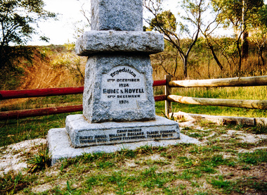
Photograph, Hume and Hovell Monument, Broadford, Autumn Excursion, Hume and Hovell's 1824 expedition, 26 May 1996, 26/05/1996
... Disappointment (Hume and Hovell's difficulties in "scrambling over brush and rock", "leeches in forest, as well as no water", "cutting grass 4-5 ft. high", dreadful scrub", "devil flies") we took an easier route, saw the Strath Creek memorial in ground fog and a wonderful "field of dreams", the Hume-Hovell privately owned cricket ground with its white picket boundary fence. Now, after a steep climb, in sunshine under gums we stretched and viewed magnificent rolling hills...Disappointment (Hume and Hovell's difficulties in "scrambling over brush and rock", "leeches in forest, as well as no water", "cutting grass 4-5 ft. high", dreadful scrub", "devil flies") we took an easier route, saw the Strath Creek memorial in ground fog and a wonderful "field of dreams", the Hume-Hovell privately owned cricket ground with its white picket boundary fence. Now, after a steep climb, in sunshine under gums we stretched and viewed magnificent rolling hills ...[article by Bettina Woodburn in EDHS Newsletter No. 109, July 1996:] ON THE TRAIL OF HUME AND HOVELL - REPORT ON THE AUTUMN EXCURSION - On a green and fresh morning (Sunday 26th May 1996) the Cobb and Co coach (driven by the most obliging Peter Tampion) set off in a north easterly direction from Eltham to connect with Hume and Hovell's route on their 1824 explorations of central Victoria. The Society would follow a series of monuments erected for the 1924 centenary of the expedition from King Parrot Creek (Tuesday 7th December 1824), through Strath Creek, over Sunday Creek (Sunday 12th December 1824) at Broadford, Tullamarine, St Albans, Deer Park, through Werribee, skirting east of the You Yangs to Lara and Avalon Beach. Because their distance-measuring wheel had broken and a one degree mistake was made in calculations, the two leaders of the original group of six convict-companions arrived at Corio Bay, instead of the expected Western Port, discovered earlier by Flinders. From below Mt. Disappointment (Hume and Hovell's difficulties in "scrambling over brush and rock", "leeches in forest, as well as no water", "cutting grass 4-5 ft. high", dreadful scrub", "devil flies") we took an easier route, saw the Strath Creek memorial in ground fog and a wonderful "field of dreams", the Hume-Hovell privately owned cricket ground with its white picket boundary fence. Now, after a steep climb, in sunshine under gums we stretched and viewed magnificent rolling hills and fog-filled valleys - not "smoke from Aborigines' bush fires". After morning tea at Broadford we followed the Sunday Creek valley beside the Hume Freeway, passed the Wallan Wallan Rest Area (more appropriately Hume and Hovell Rest Area) to tum right at Beveridge. In Gellibrand Hill Park, near the headwaters of the Moonee Ponds Creek, we experienced the landscape the first European settlers saw - huge river red gums and rolling pastures. The gardens and sheltered courtyard of the 1840s, timber, brought from .....[?] prefabricated Woodlands Homestead, provided a pleasant lunch stop. We enjoyed a private tour, panoramic views over Melbourne and surroundings and the excitement of arriving and departing aircraft. Our next river crossing was at Werribee, "in a vast treeless plain", then we drove on by-ways no coach had previously travelled, to find "an immense sheet of water" salty Corio Bay, off-course to the west. In late afternoon of a super, calm, late autumn day we headed homewards. Back at Eltham we were rather surprised to find that we had travelled a total of 347 km. Thanks again to Russell Yeoman for his research and organization. What a wonderful day! Colour photographactivities, broadford, hume and hovell, monument -
 Eltham District Historical Society Inc
Photograph, Strath Creek, Autumn Excursion, Hume and Hovell's 1824 expedition, 26 May 1996, 26/05/1996
... Disappointment (Hume and Hovell's difficulties in "scrambling over brush and rock", "leeches in forest, as well as no water", "cutting grass 4-5 ft. high", dreadful scrub", "devil flies") we took an easier route, saw the Strath Creek memorial in ground fog and a wonderful "field of dreams", the Hume-Hovell privately owned cricket ground with its white picket boundary fence. Now, after a steep climb, in sunshine under gums we stretched and viewed magnificent rolling hills...Disappointment (Hume and Hovell's difficulties in "scrambling over brush and rock", "leeches in forest, as well as no water", "cutting grass 4-5 ft. high", dreadful scrub", "devil flies") we took an easier route, saw the Strath Creek memorial in ground fog and a wonderful "field of dreams", the Hume-Hovell privately owned cricket ground with its white picket boundary fence. Now, after a steep climb, in sunshine under gums we stretched and viewed magnificent rolling hills ...[article by Bettina Woodburn in EDHS Newsletter No. 109, July 1996:] ON THE TRAIL OF HUME AND HOVELL - REPORT ON THE AUTUMN EXCURSION - On a green and fresh morning (Sunday 26th May 1996) the Cobb and Co coach (driven by the most obliging Peter Tampion) set off in a north easterly direction from Eltham to connect with Hume and Hovell's route on their 1824 explorations of central Victoria. The Society would follow a series of monuments erected for the 1924 centenary of the expedition from King Parrot Creek (Tuesday 7th December 1824), through Strath Creek, over Sunday Creek (Sunday 12th December 1824) at Broadford, Tullamarine, St Albans, Deer Park, through Werribee, skirting east of the You Yangs to Lara and Avalon Beach. Because their distance-measuring wheel had broken and a one degree mistake was made in calculations, the two leaders of the original group of six convict-companions arrived at Corio Bay, instead of the expected Western Port, discovered earlier by Flinders. From below Mt. Disappointment (Hume and Hovell's difficulties in "scrambling over brush and rock", "leeches in forest, as well as no water", "cutting grass 4-5 ft. high", dreadful scrub", "devil flies") we took an easier route, saw the Strath Creek memorial in ground fog and a wonderful "field of dreams", the Hume-Hovell privately owned cricket ground with its white picket boundary fence. Now, after a steep climb, in sunshine under gums we stretched and viewed magnificent rolling hills and fog-filled valleys - not "smoke from Aborigines' bush fires". After morning tea at Broadford we followed the Sunday Creek valley beside the Hume Freeway, passed the Wallan Wallan Rest Area (more appropriately Hume and Hovell Rest Area) to tum right at Beveridge. In Gellibrand Hill Park, near the headwaters of the Moonee Ponds Creek, we experienced the landscape the first European settlers saw - huge river red gums and rolling pastures. The gardens and sheltered courtyard of the 1840s, timber, brought from .....[?] prefabricated Woodlands Homestead, provided a pleasant lunch stop. We enjoyed a private tour, panoramic views over Melbourne and surroundings and the excitement of arriving and departing aircraft. Our next river crossing was at Werribee, "in a vast treeless plain", then we drove on by-ways no coach had previously travelled, to find "an immense sheet of water" salty Corio Bay, off-course to the west. In late afternoon of a super, calm, late autumn day we headed homewards. Back at Eltham we were rather surprised to find that we had travelled a total of 347 km. Thanks again to Russell Yeoman for his research and organization. What a wonderful day! Colour photographactivities, monument, hume and hovell, murchison valley, strath creek -
 Eltham District Historical Society Inc
Photograph, Murchison Gap viewed from Strath Creek, Autumn Excursion, Hume and Hovell's 1824 expedition, 26 May 1996, 26/05/1996
... Disappointment (Hume and Hovell's difficulties in "scrambling over brush and rock", "leeches in forest, as well as no water", "cutting grass 4-5 ft. high", dreadful scrub", "devil flies") we took an easier route, saw the Strath Creek memorial in ground fog and a wonderful "field of dreams", the Hume-Hovell privately owned cricket ground with its white picket boundary fence. Now, after a steep climb, in sunshine under gums we stretched and viewed magnificent rolling hills...Disappointment (Hume and Hovell's difficulties in "scrambling over brush and rock", "leeches in forest, as well as no water", "cutting grass 4-5 ft. high", dreadful scrub", "devil flies") we took an easier route, saw the Strath Creek memorial in ground fog and a wonderful "field of dreams", the Hume-Hovell privately owned cricket ground with its white picket boundary fence. Now, after a steep climb, in sunshine under gums we stretched and viewed magnificent rolling hills ...[article by Bettina Woodburn in EDHS Newsletter No. 109, July 1996:] ON THE TRAIL OF HUME AND HOVELL - REPORT ON THE AUTUMN EXCURSION - On a green and fresh morning (Sunday 26th May 1996) the Cobb and Co coach (driven by the most obliging Peter Tampion) set off in a north easterly direction from Eltham to connect with Hume and Hovell's route on their 1824 explorations of central Victoria. The Society would follow a series of monuments erected for the 1924 centenary of the expedition from King Parrot Creek (Tuesday 7th December 1824), through Strath Creek, over Sunday Creek (Sunday 12th December 1824) at Broadford, Tullamarine, St Albans, Deer Park, through Werribee, skirting east of the You Yangs to Lara and Avalon Beach. Because their distance-measuring wheel had broken and a one degree mistake was made in calculations, the two leaders of the original group of six convict-companions arrived at Corio Bay, instead of the expected Western Port, discovered earlier by Flinders. From below Mt. Disappointment (Hume and Hovell's difficulties in "scrambling over brush and rock", "leeches in forest, as well as no water", "cutting grass 4-5 ft. high", dreadful scrub", "devil flies") we took an easier route, saw the Strath Creek memorial in ground fog and a wonderful "field of dreams", the Hume-Hovell privately owned cricket ground with its white picket boundary fence. Now, after a steep climb, in sunshine under gums we stretched and viewed magnificent rolling hills and fog-filled valleys - not "smoke from Aborigines' bush fires". After morning tea at Broadford we followed the Sunday Creek valley beside the Hume Freeway, passed the Wallan Wallan Rest Area (more appropriately Hume and Hovell Rest Area) to tum right at Beveridge. In Gellibrand Hill Park, near the headwaters of the Moonee Ponds Creek, we experienced the landscape the first European settlers saw - huge river red gums and rolling pastures. The gardens and sheltered courtyard of the 1840s, timber, brought from .....[?] prefabricated Woodlands Homestead, provided a pleasant lunch stop. We enjoyed a private tour, panoramic views over Melbourne and surroundings and the excitement of arriving and departing aircraft. Our next river crossing was at Werribee, "in a vast treeless plain", then we drove on by-ways no coach had previously travelled, to find "an immense sheet of water" salty Corio Bay, off-course to the west. In late afternoon of a super, calm, late autumn day we headed homewards. Back at Eltham we were rather surprised to find that we had travelled a total of 347 km. Thanks again to Russell Yeoman for his research and organization. What a wonderful day! Colour photographactivities, hume and hovell, murchison valley, murchison gap, strath creek -
 Eltham District Historical Society Inc
Photograph, Autumn Excursion, Hume and Hovell's 1824 expedition, 26 May 1996, 26/05/1996
... Disappointment (Hume and Hovell's difficulties in "scrambling over brush and rock", "leeches in forest, as well as no water", "cutting grass 4-5 ft. high", dreadful scrub", "devil flies") we took an easier route, saw the Strath Creek memorial in ground fog and a wonderful "field of dreams", the Hume-Hovell privately owned cricket ground with its white picket boundary fence. Now, after a steep climb, in sunshine under gums we stretched and viewed magnificent rolling hills...Disappointment (Hume and Hovell's difficulties in "scrambling over brush and rock", "leeches in forest, as well as no water", "cutting grass 4-5 ft. high", dreadful scrub", "devil flies") we took an easier route, saw the Strath Creek memorial in ground fog and a wonderful "field of dreams", the Hume-Hovell privately owned cricket ground with its white picket boundary fence. Now, after a steep climb, in sunshine under gums we stretched and viewed magnificent rolling hills ...[article by Bettina Woodburn in EDHS Newsletter No. 109, July 1996:] ON THE TRAIL OF HUME AND HOVELL - REPORT ON THE AUTUMN EXCURSION - On a green and fresh morning (Sunday 26th May 1996) the Cobb and Co coach (driven by the most obliging Peter Tampion) set off in a north easterly direction from Eltham to connect with Hume and Hovell's route on their 1824 explorations of central Victoria. The Society would follow a series of monuments erected for the 1924 centenary of the expedition from King Parrot Creek (Tuesday 7th December 1824), through Strath Creek, over Sunday Creek (Sunday 12th December 1824) at Broadford, Tullamarine, St Albans, Deer Park, through Werribee, skirting east of the You Yangs to Lara and Avalon Beach. Because their distance-measuring wheel had broken and a one degree mistake was made in calculations, the two leaders of the original group of six convict-companions arrived at Corio Bay, instead of the expected Western Port, discovered earlier by Flinders. From below Mt. Disappointment (Hume and Hovell's difficulties in "scrambling over brush and rock", "leeches in forest, as well as no water", "cutting grass 4-5 ft. high", dreadful scrub", "devil flies") we took an easier route, saw the Strath Creek memorial in ground fog and a wonderful "field of dreams", the Hume-Hovell privately owned cricket ground with its white picket boundary fence. Now, after a steep climb, in sunshine under gums we stretched and viewed magnificent rolling hills and fog-filled valleys - not "smoke from Aborigines' bush fires". After morning tea at Broadford we followed the Sunday Creek valley beside the Hume Freeway, passed the Wallan Wallan Rest Area (more appropriately Hume and Hovell Rest Area) to tum right at Beveridge. In Gellibrand Hill Park, near the headwaters of the Moonee Ponds Creek, we experienced the landscape the first European settlers saw - huge river red gums and rolling pastures. The gardens and sheltered courtyard of the 1840s, timber, brought from .....[?] prefabricated Woodlands Homestead, provided a pleasant lunch stop. We enjoyed a private tour, panoramic views over Melbourne and surroundings and the excitement of arriving and departing aircraft. Our next river crossing was at Werribee, "in a vast treeless plain", then we drove on by-ways no coach had previously travelled, to find "an immense sheet of water" salty Corio Bay, off-course to the west. In late afternoon of a super, calm, late autumn day we headed homewards. Back at Eltham we were rather surprised to find that we had travelled a total of 347 km. Thanks again to Russell Yeoman for his research and organization. What a wonderful day! Colour photographactivities, hume and hovell -
 Eltham District Historical Society Inc
Photograph, Sign to Hume and Hovell Cricket Ground, at Allandale Road, Strath Creek, Autumn Excursion, Hume and Hovell's 1824 expedition, 26 May 1996, 26/05/1996
... Disappointment (Hume and Hovell's difficulties in "scrambling over brush and rock", "leeches in forest, as well as no water", "cutting grass 4-5 ft. high", dreadful scrub", "devil flies") we took an easier route, saw the Strath Creek memorial in ground fog and a wonderful "field of dreams", the Hume-Hovell privately owned cricket ground with its white picket boundary fence. Now, after a steep climb, in sunshine under gums we stretched and viewed magnificent rolling hills...Disappointment (Hume and Hovell's difficulties in "scrambling over brush and rock", "leeches in forest, as well as no water", "cutting grass 4-5 ft. high", dreadful scrub", "devil flies") we took an easier route, saw the Strath Creek memorial in ground fog and a wonderful "field of dreams", the Hume-Hovell privately owned cricket ground with its white picket boundary fence. Now, after a steep climb, in sunshine under gums we stretched and viewed magnificent rolling hills ...[article by Bettina Woodburn in EDHS Newsletter No. 109, July 1996:] ON THE TRAIL OF HUME AND HOVELL - REPORT ON THE AUTUMN EXCURSION - On a green and fresh morning (Sunday 26th May 1996) the Cobb and Co coach (driven by the most obliging Peter Tampion) set off in a north easterly direction from Eltham to connect with Hume and Hovell's route on their 1824 explorations of central Victoria. The Society would follow a series of monuments erected for the 1924 centenary of the expedition from King Parrot Creek (Tuesday 7th December 1824), through Strath Creek, over Sunday Creek (Sunday 12th December 1824) at Broadford, Tullamarine, St Albans, Deer Park, through Werribee, skirting east of the You Yangs to Lara and Avalon Beach. Because their distance-measuring wheel had broken and a one degree mistake was made in calculations, the two leaders of the original group of six convict-companions arrived at Corio Bay, instead of the expected Western Port, discovered earlier by Flinders. From below Mt. Disappointment (Hume and Hovell's difficulties in "scrambling over brush and rock", "leeches in forest, as well as no water", "cutting grass 4-5 ft. high", dreadful scrub", "devil flies") we took an easier route, saw the Strath Creek memorial in ground fog and a wonderful "field of dreams", the Hume-Hovell privately owned cricket ground with its white picket boundary fence. Now, after a steep climb, in sunshine under gums we stretched and viewed magnificent rolling hills and fog-filled valleys - not "smoke from Aborigines' bush fires". After morning tea at Broadford we followed the Sunday Creek valley beside the Hume Freeway, passed the Wallan Wallan Rest Area (more appropriately Hume and Hovell Rest Area) to tum right at Beveridge. In Gellibrand Hill Park, near the headwaters of the Moonee Ponds Creek, we experienced the landscape the first European settlers saw - huge river red gums and rolling pastures. The gardens and sheltered courtyard of the 1840s, timber, brought from .....[?] prefabricated Woodlands Homestead, provided a pleasant lunch stop. We enjoyed a private tour, panoramic views over Melbourne and surroundings and the excitement of arriving and departing aircraft. Our next river crossing was at Werribee, "in a vast treeless plain", then we drove on by-ways no coach had previously travelled, to find "an immense sheet of water" salty Corio Bay, off-course to the west. In late afternoon of a super, calm, late autumn day we headed homewards. Back at Eltham we were rather surprised to find that we had travelled a total of 347 km. Thanks again to Russell Yeoman for his research and organization. What a wonderful day! Colour photographactivities, hume and hovell, allandale road, strath creek -
 Eltham District Historical Society Inc
Photograph, Autumn Excursion, Hume and Hovell's 1824 expedition, 26 May 1996, 26/05/1996
... Disappointment (Hume and Hovell's difficulties in "scrambling over brush and rock", "leeches in forest, as well as no water", "cutting grass 4-5 ft. high", dreadful scrub", "devil flies") we took an easier route, saw the Strath Creek memorial in ground fog and a wonderful "field of dreams", the Hume-Hovell privately owned cricket ground with its white picket boundary fence. Now, after a steep climb, in sunshine under gums we stretched and viewed magnificent rolling hills...Disappointment (Hume and Hovell's difficulties in "scrambling over brush and rock", "leeches in forest, as well as no water", "cutting grass 4-5 ft. high", dreadful scrub", "devil flies") we took an easier route, saw the Strath Creek memorial in ground fog and a wonderful "field of dreams", the Hume-Hovell privately owned cricket ground with its white picket boundary fence. Now, after a steep climb, in sunshine under gums we stretched and viewed magnificent rolling hills ...[article by Bettina Woodburn in EDHS Newsletter No. 109, July 1996:] ON THE TRAIL OF HUME AND HOVELL - REPORT ON THE AUTUMN EXCURSION - On a green and fresh morning (Sunday 26th May 1996) the Cobb and Co coach (driven by the most obliging Peter Tampion) set off in a north easterly direction from Eltham to connect with Hume and Hovell's route on their 1824 explorations of central Victoria. The Society would follow a series of monuments erected for the 1924 centenary of the expedition from King Parrot Creek (Tuesday 7th December 1824), through Strath Creek, over Sunday Creek (Sunday 12th December 1824) at Broadford, Tullamarine, St Albans, Deer Park, through Werribee, skirting east of the You Yangs to Lara and Avalon Beach. Because their distance-measuring wheel had broken and a one degree mistake was made in calculations, the two leaders of the original group of six convict-companions arrived at Corio Bay, instead of the expected Western Port, discovered earlier by Flinders. From below Mt. Disappointment (Hume and Hovell's difficulties in "scrambling over brush and rock", "leeches in forest, as well as no water", "cutting grass 4-5 ft. high", dreadful scrub", "devil flies") we took an easier route, saw the Strath Creek memorial in ground fog and a wonderful "field of dreams", the Hume-Hovell privately owned cricket ground with its white picket boundary fence. Now, after a steep climb, in sunshine under gums we stretched and viewed magnificent rolling hills and fog-filled valleys - not "smoke from Aborigines' bush fires". After morning tea at Broadford we followed the Sunday Creek valley beside the Hume Freeway, passed the Wallan Wallan Rest Area (more appropriately Hume and Hovell Rest Area) to tum right at Beveridge. In Gellibrand Hill Park, near the headwaters of the Moonee Ponds Creek, we experienced the landscape the first European settlers saw - huge river red gums and rolling pastures. The gardens and sheltered courtyard of the 1840s, timber, brought from .....[?] prefabricated Woodlands Homestead, provided a pleasant lunch stop. We enjoyed a private tour, panoramic views over Melbourne and surroundings and the excitement of arriving and departing aircraft. Our next river crossing was at Werribee, "in a vast treeless plain", then we drove on by-ways no coach had previously travelled, to find "an immense sheet of water" salty Corio Bay, off-course to the west. In late afternoon of a super, calm, late autumn day we headed homewards. Back at Eltham we were rather surprised to find that we had travelled a total of 347 km. Thanks again to Russell Yeoman for his research and organization. What a wonderful day! Colour photographactivities, hume and hovell -
 Eltham District Historical Society Inc
Photograph, Murchison Gap, Autumn Excursion, Hume and Hovell's 1824 expedition, 26 May 1996, 26/05/1996
... Disappointment (Hume and Hovell's difficulties in "scrambling over brush and rock", "leeches in forest, as well as no water", "cutting grass 4-5 ft. high", dreadful scrub", "devil flies") we took an easier route, saw the Strath Creek memorial in ground fog and a wonderful "field of dreams", the Hume-Hovell privately owned cricket ground with its white picket boundary fence. Now, after a steep climb, in sunshine under gums we stretched and viewed magnificent rolling hills...Disappointment (Hume and Hovell's difficulties in "scrambling over brush and rock", "leeches in forest, as well as no water", "cutting grass 4-5 ft. high", dreadful scrub", "devil flies") we took an easier route, saw the Strath Creek memorial in ground fog and a wonderful "field of dreams", the Hume-Hovell privately owned cricket ground with its white picket boundary fence. Now, after a steep climb, in sunshine under gums we stretched and viewed magnificent rolling hills ...[article by Bettina Woodburn in EDHS Newsletter No. 109, July 1996:] ON THE TRAIL OF HUME AND HOVELL - REPORT ON THE AUTUMN EXCURSION - On a green and fresh morning (Sunday 26th May 1996) the Cobb and Co coach (driven by the most obliging Peter Tampion) set off in a north easterly direction from Eltham to connect with Hume and Hovell's route on their 1824 explorations of central Victoria. The Society would follow a series of monuments erected for the 1924 centenary of the expedition from King Parrot Creek (Tuesday 7th December 1824), through Strath Creek, over Sunday Creek (Sunday 12th December 1824) at Broadford, Tullamarine, St Albans, Deer Park, through Werribee, skirting east of the You Yangs to Lara and Avalon Beach. Because their distance-measuring wheel had broken and a one degree mistake was made in calculations, the two leaders of the original group of six convict-companions arrived at Corio Bay, instead of the expected Western Port, discovered earlier by Flinders. From below Mt. Disappointment (Hume and Hovell's difficulties in "scrambling over brush and rock", "leeches in forest, as well as no water", "cutting grass 4-5 ft. high", dreadful scrub", "devil flies") we took an easier route, saw the Strath Creek memorial in ground fog and a wonderful "field of dreams", the Hume-Hovell privately owned cricket ground with its white picket boundary fence. Now, after a steep climb, in sunshine under gums we stretched and viewed magnificent rolling hills and fog-filled valleys - not "smoke from Aborigines' bush fires". After morning tea at Broadford we followed the Sunday Creek valley beside the Hume Freeway, passed the Wallan Wallan Rest Area (more appropriately Hume and Hovell Rest Area) to tum right at Beveridge. In Gellibrand Hill Park, near the headwaters of the Moonee Ponds Creek, we experienced the landscape the first European settlers saw - huge river red gums and rolling pastures. The gardens and sheltered courtyard of the 1840s, timber, brought from .....[?] prefabricated Woodlands Homestead, provided a pleasant lunch stop. We enjoyed a private tour, panoramic views over Melbourne and surroundings and the excitement of arriving and departing aircraft. Our next river crossing was at Werribee, "in a vast treeless plain", then we drove on by-ways no coach had previously travelled, to find "an immense sheet of water" salty Corio Bay, off-course to the west. In late afternoon of a super, calm, late autumn day we headed homewards. Back at Eltham we were rather surprised to find that we had travelled a total of 347 km. Thanks again to Russell Yeoman for his research and organization. What a wonderful day! Three colour photographsactivities, murchison gap, murchison valley -
 Eltham District Historical Society Inc
Photograph, Hume and Hovell Monument, Broadford, Autumn Excursion, Hume and Hovell's 1824 expedition, 26 May 1996, 26/05/1996
... Disappointment (Hume and Hovell's difficulties in "scrambling over brush and rock", "leeches in forest, as well as no water", "cutting grass 4-5 ft. high", dreadful scrub", "devil flies") we took an easier route, saw the Strath Creek memorial in ground fog and a wonderful "field of dreams", the Hume-Hovell privately owned cricket ground with its white picket boundary fence. Now, after a steep climb, in sunshine under gums we stretched and viewed magnificent rolling hills...Disappointment (Hume and Hovell's difficulties in "scrambling over brush and rock", "leeches in forest, as well as no water", "cutting grass 4-5 ft. high", dreadful scrub", "devil flies") we took an easier route, saw the Strath Creek memorial in ground fog and a wonderful "field of dreams", the Hume-Hovell privately owned cricket ground with its white picket boundary fence. Now, after a steep climb, in sunshine under gums we stretched and viewed magnificent rolling hills ...[article by Bettina Woodburn in EDHS Newsletter No. 109, July 1996:] ON THE TRAIL OF HUME AND HOVELL - REPORT ON THE AUTUMN EXCURSION - On a green and fresh morning (Sunday 26th May 1996) the Cobb and Co coach (driven by the most obliging Peter Tampion) set off in a north easterly direction from Eltham to connect with Hume and Hovell's route on their 1824 explorations of central Victoria. The Society would follow a series of monuments erected for the 1924 centenary of the expedition from King Parrot Creek (Tuesday 7th December 1824), through Strath Creek, over Sunday Creek (Sunday 12th December 1824) at Broadford, Tullamarine, St Albans, Deer Park, through Werribee, skirting east of the You Yangs to Lara and Avalon Beach. Because their distance-measuring wheel had broken and a one degree mistake was made in calculations, the two leaders of the original group of six convict-companions arrived at Corio Bay, instead of the expected Western Port, discovered earlier by Flinders. From below Mt. Disappointment (Hume and Hovell's difficulties in "scrambling over brush and rock", "leeches in forest, as well as no water", "cutting grass 4-5 ft. high", dreadful scrub", "devil flies") we took an easier route, saw the Strath Creek memorial in ground fog and a wonderful "field of dreams", the Hume-Hovell privately owned cricket ground with its white picket boundary fence. Now, after a steep climb, in sunshine under gums we stretched and viewed magnificent rolling hills and fog-filled valleys - not "smoke from Aborigines' bush fires". After morning tea at Broadford we followed the Sunday Creek valley beside the Hume Freeway, passed the Wallan Wallan Rest Area (more appropriately Hume and Hovell Rest Area) to tum right at Beveridge. In Gellibrand Hill Park, near the headwaters of the Moonee Ponds Creek, we experienced the landscape the first European settlers saw - huge river red gums and rolling pastures. The gardens and sheltered courtyard of the 1840s, timber, brought from .....[?] prefabricated Woodlands Homestead, provided a pleasant lunch stop. We enjoyed a private tour, panoramic views over Melbourne and surroundings and the excitement of arriving and departing aircraft. Our next river crossing was at Werribee, "in a vast treeless plain", then we drove on by-ways no coach had previously travelled, to find "an immense sheet of water" salty Corio Bay, off-course to the west. In late afternoon of a super, calm, late autumn day we headed homewards. Back at Eltham we were rather surprised to find that we had travelled a total of 347 km. Thanks again to Russell Yeoman for his research and organization. What a wonderful day! Colour photographactivities, broadford, hume and hovell, monument -
 Eltham District Historical Society Inc
Photograph, Hume and Hovell Monument, Autumn Excursion, Hume and Hovell's 1824 expedition, 26 May 1996, 26/05/1996
... Disappointment (Hume and Hovell's difficulties in "scrambling over brush and rock", "leeches in forest, as well as no water", "cutting grass 4-5 ft. high", dreadful scrub", "devil flies") we took an easier route, saw the Strath Creek memorial in ground fog and a wonderful "field of dreams", the Hume-Hovell privately owned cricket ground with its white picket boundary fence. Now, after a steep climb, in sunshine under gums we stretched and viewed magnificent rolling hills...Disappointment (Hume and Hovell's difficulties in "scrambling over brush and rock", "leeches in forest, as well as no water", "cutting grass 4-5 ft. high", dreadful scrub", "devil flies") we took an easier route, saw the Strath Creek memorial in ground fog and a wonderful "field of dreams", the Hume-Hovell privately owned cricket ground with its white picket boundary fence. Now, after a steep climb, in sunshine under gums we stretched and viewed magnificent rolling hills ...[article by Bettina Woodburn in EDHS Newsletter No. 109, July 1996:] ON THE TRAIL OF HUME AND HOVELL - REPORT ON THE AUTUMN EXCURSION - On a green and fresh morning (Sunday 26th May 1996) the Cobb and Co coach (driven by the most obliging Peter Tampion) set off in a north easterly direction from Eltham to connect with Hume and Hovell's route on their 1824 explorations of central Victoria. The Society would follow a series of monuments erected for the 1924 centenary of the expedition from King Parrot Creek (Tuesday 7th December 1824), through Strath Creek, over Sunday Creek (Sunday 12th December 1824) at Broadford, Tullamarine, St Albans, Deer Park, through Werribee, skirting east of the You Yangs to Lara and Avalon Beach. Because their distance-measuring wheel had broken and a one degree mistake was made in calculations, the two leaders of the original group of six convict-companions arrived at Corio Bay, instead of the expected Western Port, discovered earlier by Flinders. From below Mt. Disappointment (Hume and Hovell's difficulties in "scrambling over brush and rock", "leeches in forest, as well as no water", "cutting grass 4-5 ft. high", dreadful scrub", "devil flies") we took an easier route, saw the Strath Creek memorial in ground fog and a wonderful "field of dreams", the Hume-Hovell privately owned cricket ground with its white picket boundary fence. Now, after a steep climb, in sunshine under gums we stretched and viewed magnificent rolling hills and fog-filled valleys - not "smoke from Aborigines' bush fires". After morning tea at Broadford we followed the Sunday Creek valley beside the Hume Freeway, passed the Wallan Wallan Rest Area (more appropriately Hume and Hovell Rest Area) to tum right at Beveridge. In Gellibrand Hill Park, near the headwaters of the Moonee Ponds Creek, we experienced the landscape the first European settlers saw - huge river red gums and rolling pastures. The gardens and sheltered courtyard of the 1840s, timber, brought from .....[?] prefabricated Woodlands Homestead, provided a pleasant lunch stop. We enjoyed a private tour, panoramic views over Melbourne and surroundings and the excitement of arriving and departing aircraft. Our next river crossing was at Werribee, "in a vast treeless plain", then we drove on by-ways no coach had previously travelled, to find "an immense sheet of water" salty Corio Bay, off-course to the west. In late afternoon of a super, calm, late autumn day we headed homewards. Back at Eltham we were rather surprised to find that we had travelled a total of 347 km. Thanks again to Russell Yeoman for his research and organization. What a wonderful day! Two colour photographsactivities, hume and hovell, monument -
 Bendigo Historical Society Inc.
Photograph - RALPH BIRRELL COLLECTION: VIEW OF WHITE HILL
... Hill. Image shows white clay and gravel, low level bushes, possibly Chinese Scrub on site. ...Hill. Image shows white clay and gravel, low level bushes, possibly Chinese Scrub on site. ...Colour photograph of White Hill area - possibly at First White Hill. Image shows white clay and gravel, low level bushes, possibly Chinese Scrub on site. 'The rim of the pit showing an exposed boulder in situ' ( in foreground of image ) (see Mosaic 4400.220 for detailed information regarding the White Hills, written by Dr. Ralph Birrell)bendigo, mining, white hills -
 Otway Districts Historical Society
Book, Otway Light Editorial Board, The Otway Light, 1989
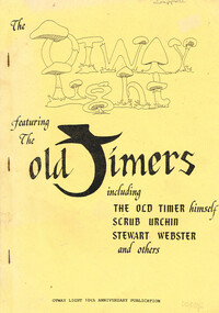
... Scrub Urchin, Stewart Webster, and others. Helen Grant (ed.). Robert Montgomery, Ellise Angel, Claire McCaffie (illus.). Lavers Hill...Scrub Urchin, Stewart Webster, and others. Helen Grant (ed.). Robert Montgomery, Ellise Angel, Claire McCaffie (illus.). Lavers Hill ...A collection of stories from the Otways that were collected for the Otway Light 10th Anniversary publication.The Otway Light featuring the Old Timers, including the Old Timer himself, Scrub Urchin, Stewart Webster, and others. Helen Grant (ed.). Robert Montgomery, Ellise Angel, Claire McCaffie (illus.). Lavers Hill (Vic); Otway Light Editorial Board; 1989. 98 p.; illus. Soft cover.Melba Gully (21st March 1975)otways; stories; sketches; history; -
 Bendigo Historical Society Inc.
Document - PETER ELLIS COLLECTION: NOTES MENTIONING WHIPSTICK REGION
... Scrub... Mandurang Forest... One Tree Hill...Region Bendigo Block Bendigo Field Naturalists Club Shipstick Scrub Mandurang Forest One Tree Hill Public park Redvers J Eddy Coliban/Sandhurst Water Supply Reserve Four pages of typed notes mentioning the Whipstick Region, Mandurang Forest, Jackass Flat, Diamond Hill Area, One Tree Hill, and the Coliban/Sandhurst Water Supply Reserve. ...Four pages of typed notes mentioning the Whipstick Region, Mandurang Forest, Jackass Flat, Diamond Hill Area, One Tree Hill, and the Coliban/Sandhurst Water Supply Reserve. Mentioned are the Birds, Mammals, Geology, Flora, Ground Flora, Orchids,Lilies, Mistletoe, Ferns and Grasses of some of the areas.bendigo, parks and gardens, public reserves, peter ellis collection, north/central l.c.c. region bendigo block, bendigo field naturalists club, shipstick scrub, mandurang forest, one tree hill public park, redvers j eddy, coliban/sandhurst water supply reserve -
 Bendigo Historical Society Inc.
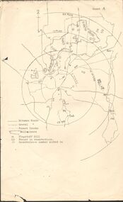
Map - PETER ELLIS COLLECTION: MAP OF WHIPSTICK
... Hill, fenced in reservations and reservoirs are marked. Also, a circle and part circles of 5-, 10-, 15- and 20-mile radius is marked. North & South are marked. Sheet B is an enlarged area of the Whipstick Scrub...Hill, fenced in reservations and reservoirs are marked. Also, a circle and part circles of 5-, 10-, 15- and 20-mile radius is marked. North & South are marked. Sheet B is an enlarged area of the Whipstick Scrub ...Two maps of the Whipstick - Sheet A and Sheet B. Sheet A shows the Whipstick in relation to Bendigo and some surrounding places. Bitumen roads, gravel, forest tracks, Mallee Areas, Flagstaff Hill, fenced in reservations and reservoirs are marked. Also, a circle and part circles of 5-, 10-, 15- and 20-mile radius is marked. North & South are marked. Sheet B is an enlarged area of the Whipstick Scrub area. North and South is marked. There are a number of letters written over both maps.map, bendigo, peter ellis collection, the whipstick, flagstaff hill