Showing 39 items matching "sherwood road"
-
 Surrey Hills Historical Society Collection
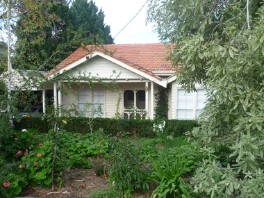
Photograph - 1 Sherwood Road, Surrey Hills, On The Street Where You Live Project
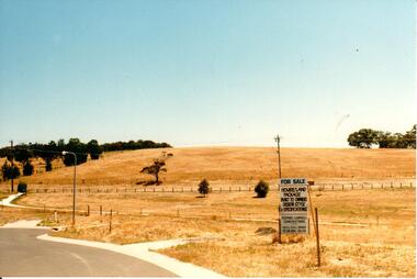
... 1 Sherwood Road, Surrey Hills...On The Street Where You Live Project Photograph 1 Sherwood Road, Surrey Hills ...Photos documenting this address as part of a photographic series undertaken by volunteer photographers during 2013 and 2014 for The Street Where You Live Project. This was organised through the Surrey Hills Neighbourhood Centre and covered the postcode 3127 in the cities of Boroondara and Whitehorse.These photos provide a snapshot of real estate in the suburbs of Mont Albert and Surrey Hills during a period of rapid change with many properties on large blocks demolished to create higher density residential development or renewal of single dwellings. At particular risk were properties not covered by heritage overlays, especially interwar housing and post 1950's housing. -
 Surrey Hills Historical Society Collection
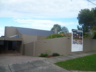
Photograph - 3 Sherwood Road, Surrey Hills, On The Street Where You Live Project
... 3 Sherwood Road, Surrey Hills...On The Street Where You Live Project Photograph 3 Sherwood Road, Surrey Hills ...Photos documenting this address as part of a photographic series undertaken by volunteer photographers during 2013 and 2014 for The Street Where You Live Project. This was organised through the Surrey Hills Neighbourhood Centre and covered the postcode 3127 in the cities of Boroondara and Whitehorse.These photos provide a snapshot of real estate in the suburbs of Mont Albert and Surrey Hills during a period of rapid change with many properties on large blocks demolished to create higher density residential development or renewal of single dwellings. At particular risk were properties not covered by heritage overlays, especially interwar housing and post 1950's housing. -
 Surrey Hills Historical Society Collection
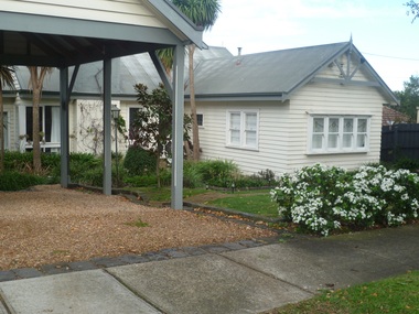
Photograph - 5 Sherwood Road, Surrey Hills, On The Street Where You Live Project
... 5 Sherwood Road, Surrey Hills...On The Street Where You Live Project Photograph 5 Sherwood Road, Surrey Hills ...Photos documenting this address as part of a photographic series undertaken by volunteer photographers during 2013 and 2014 for The Street Where You Live Project. This was organised through the Surrey Hills Neighbourhood Centre and covered the postcode 3127 in the cities of Boroondara and Whitehorse.These photos provide a snapshot of real estate in the suburbs of Mont Albert and Surrey Hills during a period of rapid change with many properties on large blocks demolished to create higher density residential development or renewal of single dwellings. At particular risk were properties not covered by heritage overlays, especially interwar housing and post 1950's housing. -
 Surrey Hills Historical Society Collection
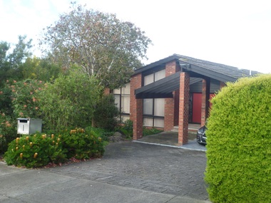
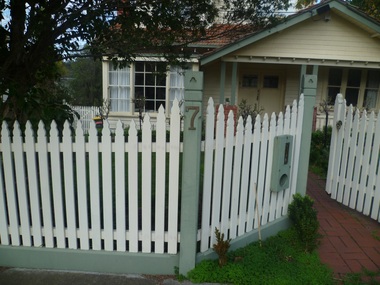
Photograph - 7 Sherwood Road, Surrey Hills, On The Street Where You Live Project
... 7 Sherwood Road, Surrey Hills...On The Street Where You Live Project Photograph 7 Sherwood Road, Surrey Hills ...Photos documenting this address as part of a photographic series undertaken by volunteer photographers during 2013 and 2014 for The Street Where You Live Project. This was organised through the Surrey Hills Neighbourhood Centre and covered the postcode 3127 in the cities of Boroondara and Whitehorse.These photos provide a snapshot of real estate in the suburbs of Mont Albert and Surrey Hills during a period of rapid change with many properties on large blocks demolished to create higher density residential development or renewal of single dwellings. At particular risk were properties not covered by heritage overlays, especially interwar housing and post 1950's housing. -
 Surrey Hills Historical Society Collection
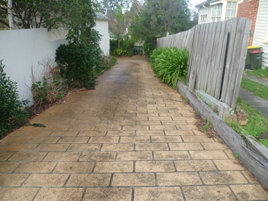
Photograph - 9 Sherwood Road, Surrey Hills, On The Street Where You Live Project
... 9 Sherwood Road, Surrey Hills...On The Street Where You Live Project Photograph 9 Sherwood Road, Surrey Hills ...Photos documenting this address as part of a photographic series undertaken by volunteer photographers during 2013 and 2014 for The Street Where You Live Project. This was organised through the Surrey Hills Neighbourhood Centre and covered the postcode 3127 in the cities of Boroondara and Whitehorse.These photos provide a snapshot of real estate in the suburbs of Mont Albert and Surrey Hills during a period of rapid change with many properties on large blocks demolished to create higher density residential development or renewal of single dwellings. At particular risk were properties not covered by heritage overlays, especially interwar housing and post 1950's housing. -
 Surrey Hills Historical Society Collection
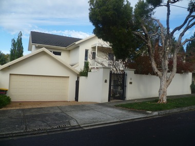
Photograph - 11 Sherwood Road, Surrey Hills, On The Street Where You Live Project
... 11 Sherwood Road, Surrey Hills...On The Street Where You Live Project Photograph 11 Sherwood Road, Surrey Hills ...Photos documenting this address as part of a photographic series undertaken by volunteer photographers during 2013 and 2014 for The Street Where You Live Project. This was organised through the Surrey Hills Neighbourhood Centre and covered the postcode 3127 in the cities of Boroondara and Whitehorse.These photos provide a snapshot of real estate in the suburbs of Mont Albert and Surrey Hills during a period of rapid change with many properties on large blocks demolished to create higher density residential development or renewal of single dwellings. At particular risk were properties not covered by heritage overlays, especially interwar housing and post 1950's housing. -
 Surrey Hills Historical Society Collection
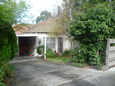
Photograph - 13 Sherwood Road, Surrey Hills, On The Street Where You Live Project
... 13 Sherwood Road, Surrey Hills...On The Street Where You Live Project Photograph 13 Sherwood Road, Surrey Hills ...Photos documenting this address as part of a photographic series undertaken by volunteer photographers during 2013 and 2014 for The Street Where You Live Project. This was organised through the Surrey Hills Neighbourhood Centre and covered the postcode 3127 in the cities of Boroondara and Whitehorse.These photos provide a snapshot of real estate in the suburbs of Mont Albert and Surrey Hills during a period of rapid change with many properties on large blocks demolished to create higher density residential development or renewal of single dwellings. At particular risk were properties not covered by heritage overlays, especially interwar housing and post 1950's housing. -
 Surrey Hills Historical Society Collection
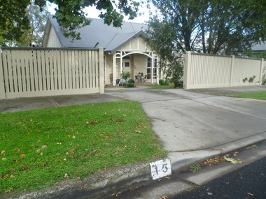
Photograph - 15 Sherwood Road, Surrey Hills, On The Street Where You Live Project
... 15 Sherwood Road, Surrey Hills...On The Street Where You Live Project Photograph 15 Sherwood Road, Surrey Hills ...Photos documenting this address as part of a photographic series undertaken by volunteer photographers during 2013 and 2014 for The Street Where You Live Project. This was organised through the Surrey Hills Neighbourhood Centre and covered the postcode 3127 in the cities of Boroondara and Whitehorse.These photos provide a snapshot of real estate in the suburbs of Mont Albert and Surrey Hills during a period of rapid change with many properties on large blocks demolished to create higher density residential development or renewal of single dwellings. At particular risk were properties not covered by heritage overlays, especially interwar housing and post 1950's housing. -
 Surrey Hills Historical Society Collection
Photograph - 17 Sherwood Road, Surrey Hills, On The Street Where You Live Project
... 17 Sherwood Road, Surrey Hills...On The Street Where You Live Project Photograph 17 Sherwood Road, Surrey Hills ...Photos documenting this address as part of a photographic series undertaken by volunteer photographers during 2013 and 2014 for The Street Where You Live Project. This was organised through the Surrey Hills Neighbourhood Centre and covered the postcode 3127 in the cities of Boroondara and Whitehorse.These photos provide a snapshot of real estate in the suburbs of Mont Albert and Surrey Hills during a period of rapid change with many properties on large blocks demolished to create higher density residential development or renewal of single dwellings. At particular risk were properties not covered by heritage overlays, especially interwar housing and post 1950's housing. -
 Surrey Hills Historical Society Collection
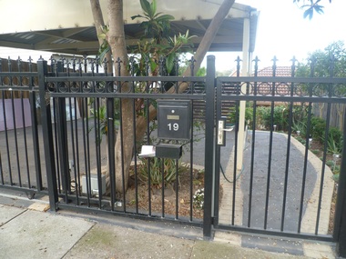
Photograph - 19 Sherwood Road, Surrey Hills, On The Street Where You Live Project
... 19 Sherwood Road, Surrey Hills...On The Street Where You Live Project Photograph 19 Sherwood Road, Surrey Hills ...Photos documenting this address as part of a photographic series undertaken by volunteer photographers during 2013 and 2014 for The Street Where You Live Project. This was organised through the Surrey Hills Neighbourhood Centre and covered the postcode 3127 in the cities of Boroondara and Whitehorse.These photos provide a snapshot of real estate in the suburbs of Mont Albert and Surrey Hills during a period of rapid change with many properties on large blocks demolished to create higher density residential development or renewal of single dwellings. At particular risk were properties not covered by heritage overlays, especially interwar housing and post 1950's housing. -
 Eltham District Historical Society Inc
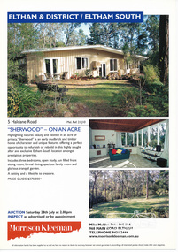
Folder, Sherwood, 5 Haldane Road, Eltham
... Sherwood, 5 Haldane Road, Eltham...road...eltham south...Sherwood...Eltham District Historical Society Inc 728 Main Rd Eltham melbourne Morrison Kleeman Real Estate sales information material gayle blackwood collection houses morrison kleeman real estate mudbrick haldane road eltham south Sherwood 1 document, 2 pages A4 Sherwood, 5 Haldane Road, Eltham Folder ...Morrison Kleeman Real Estate sales information material1 document, 2 pages A4 gayle blackwood collection, houses, morrison kleeman real estate, mudbrick, haldane road, eltham south, sherwood -
 Surrey Hills Historical Society Collection
Folder of real estate advertisements, Folders of real estate advertisements (Streets beginning with S), Various
... ...sherwood road...Surrey Hills Historical Society Collection 190A Canterbury Road Canterbury melbourne st georges avenue st james avenue salisbury avenue scheele street scottsdale street serpentine street shepherd street shepreth street sherwood road shrimpton court sir garnet road smythe avenue stanhope street streeton court suffolk road sunbury crescent surrey avenue sydenham lane sythney court A4 folders with individual pockets for each property in streets beginning with S located in Surrey Hills and Mont Albert. ...A4 folders with individual pockets for each property in streets beginning with S located in Surrey Hills and Mont Albert. Folders are ordered by street name and then chronologically by property number. Each property has its own pocket. This may include multiple real estate advertisements collected from sales over time. It may also include copies of any research undertaken by Alan Holt and / or members of the SHNCHC team. These are augmented by cards in the Alan Holt index file and by his property registers of Surrey Hills and Mont Albert.st georges avenue, st james avenue, salisbury avenue, scheele street, scottsdale street, serpentine street, shepherd street, shepreth street, sherwood road, shrimpton court, sir garnet road, smythe avenue, stanhope street, streeton court, suffolk road, sunbury crescent, surrey avenue, sydenham lane, sythney court -
 Hume City Civic Collection
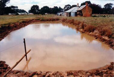
Photograph, Early 1980's
... sherwood...somerton road...Hume City Civic Collection 44 Macedon Street Sunbury melbourne The mud brick cottage and outbuilding was possibly built by James Waylett in the 1850's and it is only one of three remaining mud brick buildings in the Oaklands-Greenvale which were constructed in the late 19th Century. mud brick buildings waylett james farm buildings sherwood somerton road oaklands hunt club george evans collection A coloured photograph of farm scene. ...The mud brick cottage and outbuilding was possibly built by James Waylett in the 1850's and it is only one of three remaining mud brick buildings in the Oaklands-Greenvale which were constructed in the late 19th Century.A coloured photograph of farm scene. A dam is in the foreground and the remains of a mud brick cottage and timber and corrugated building in the middle distance. Further farm buildings can be seen in the distance.mud brick buildings, waylett, james, farm buildings, sherwood, somerton road, oaklands hunt club, george evans collection -
 Hume City Civic Collection
Photograph, c late 1990s
... A view of the Aboriginal ring and sacred site and its close proximity to a proposed housing estate at Sherwood near Racecourse Road....Despite rapid development in the area, those sites are protected heritage sites. aboriginal culture aboriginal rings sacred sites george evans collection A view of the Aboriginal ring and sacred site and its close proximity to a proposed housing estate at Sherwood near Racecourse Road. Photograph ...The series of 9 photographs were taken to be included in a study of archaeological sites and Aboriginal rings in the Sunbury area. Five earth rings which are thought to be associated with male initiation ceremonies have been identified in Sunbury. Only 3 others have been found in the rest of Victoria. Despite rapid development in the area, those sites are protected heritage sites.A view of the Aboriginal ring and sacred site and its close proximity to a proposed housing estate at Sherwood near Racecourse Road.aboriginal culture, aboriginal rings, sacred sites, george evans collection -
 Warrnambool and District Historical Society Inc.
Map - An Angler's map of the Hopkins River Estuary, Angler's map Hopkins River, 1980s
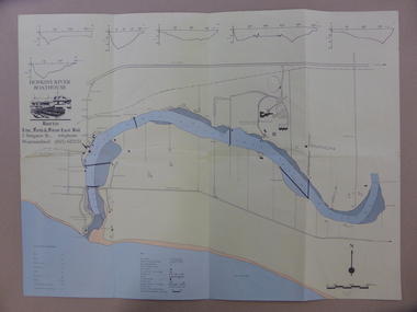
... Warrnambool and District Historical Society Inc. 2 Gilles Street (south of Merri St) Warrnambool great-ocean-road This is a map of the Hopkins River Estuary prepared by Dr John Sherwood for the benefit of anglers. ...This is a map of the Hopkins River Estuary prepared by Dr John Sherwood for the benefit of anglers. The information on the sheet includes the location of sand banks, the water depths, boat ramp facilities and public access facilities. Some of the information has been gathered from aerial photographs. The map has been produced by the Warrnambool Institute of Advanced Education which was developed in the late 1960s from the tertiary section of the Warrnambool Technical College and with all its departments established by 1984 at the Sherwood Campus five kilometres from Warrnambool on the Princes Highway. Today the site is occupied by Deakin University, Warrnambool campus. The Warrnambool Anglers’ Club has its headquarters on the banks of the Hopkins River near the mouth of the river and the Lyndoch Aged Care facility.This map is of interest as a specialist one, providing fishermen with detailed information on all aspects of the Hopkins river estuary. Fishing has been both a profession and a popular recreational pursuit for Warrnambool residents since the early days of the city’s settlement. The Hopkins River Estuary has been a focal point for fishermen throughout Warrnambool’s history. This is a sheet of paper folded three times to produce a folded map. The front cover has a black and white photograph of two fishermen with a large fish. The map of the Hopkins River Estuary is in yellow, blue and black and covers the side of one sheet and three quarters of the other side. There is an advertisement for the Hopkins River Boathouse with a black and white sketch of the boathouse and notes on the map written by Dr John Sherwood. There are several diagrams showing the water depths. The map has some silverfish damage and some tearing at the folds. warrnambool anglers’ club, history of warrnambool, hopkins river, hopkins river estuary, john sherwood -
 Warrnambool and District Historical Society Inc.
Document, Deaking Twilight Festival, 2015
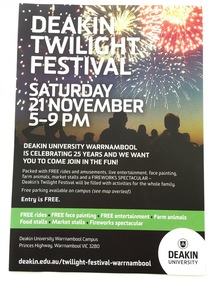
... road This is a brochure advertising the Twilight Festival at Deakin University, Warrnambool Campus, in November 2015. The festival was held to celebrate the 25th anniversary of the founding of the Warrnambool Campus of Deakin University in 1990. The Warrnambool Institute of Advanced Education had previously occupied the site at Sherwood ...This is a brochure advertising the Twilight Festival at Deakin University, Warrnambool Campus, in November 2015. The festival was held to celebrate the 25th anniversary of the founding of the Warrnambool Campus of Deakin University in 1990. The Warrnambool Institute of Advanced Education had previously occupied the site at Sherwood Park and in 1990 the Institute merged with Deakin University to form the Warrnambool Campus of that university. This brochure is of interest as a memento of the 25th anniversary celebrations of Deakin University Warrnambool. This is a single sheet of paper advertising the Deakin University Twilight Festival in November 2015. One side has a black background with a coloured image of people watching a fireworks display and white printed material on a black and green background. The other side has a white background with green and black printed material and a map of Deakin University Warrnambool campus. deakin university warrnambool, education in warrnambool, warrnambool history -
 Warrnambool and District Historical Society Inc.
Badges, Warrnambool Technical School
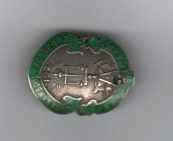
... The latter institute moved to Sherwood Park, Warrnambool and became the present-day Warrnambool campus of Deakin University. Warrnambool Technical School moved to Caramut Road, Warrnambool and is today known as Brauer College. ...road This is a Warrnambool Technical School badge of the 1920s and 30s. Warrnambool Technical School was established in Timor Street in 1913. The senior section was later called Warrnambool Technical College and then Warrnambool Institute of Advanced Education. The latter institute moved to Sherwood ...This is a Warrnambool Technical School badge of the 1920s and 30s. Warrnambool Technical School was established in Timor Street in 1913. The senior section was later called Warrnambool Technical College and then Warrnambool Institute of Advanced Education. The latter institute moved to Sherwood Park, Warrnambool and became the present-day Warrnambool campus of Deakin University. Warrnambool Technical School moved to Caramut Road, Warrnambool and is today known as Brauer College. The badge was donated by Mirth Marfell, the daughter of Henry and Helena Marfell. She was born in Warrnambool in 1919. Her grandfather, John Marfell, a Warrnambool hay and corn dealer and miller connected to the Warrnambool Co-operative Milling Company, was prominent in community and civic affairs in the town. Mirth Marfell completed her nursing training at the Warrnambool Base Hospital and served in the Australian Army Nursing Service in World War Two for five years. She then became the first Australian nursing organizer for the Victorian Royal College of Nursing. This badge is of interest, firstly as a memento of Warrnambool Technical School from the 1920s and 30s and secondly because it came from Mirth Marfell, a Warrnambool person who had a distinguished nursing career..1 Shield shaped metal and enamel badge with green border including text enclosing a silver area featuring raised images of a torch, scales, compass, hammer, nails, artist's palette, brushes , a bar and the numbers 192. A pin clip is on the reverse .2 Circular metal and enamel badge with a golden edged green border surrounding a bronze coloured centre with a stylised golden edged scarlet torch and three horizontal bars of varied length. A pin clip is on the reverse..1 WARRNAMBOOL TECn SCHOOL LABOR TO EFFICIENCY .2 WARRNAMBOOL TECHNICAL SCHOOLwarrnambool institute of advanced education, warrnambool technical school, brauer college, warrnambool co-operative milling company, victorian royal college of nursing, history of warrnambool -
 Warrnambool and District Historical Society Inc.
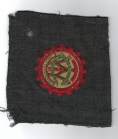
Blazer pocket, Warrnambool Technical College
... The latter institute moved to Sherwood Park, Warrnambool and became the present-day Warrnambool campus of Deakin University. Warrnambool Technical School moved to Caramut Road, Warrnambool and is today known as Brauer College. ...road This is a cloth badge from Warrnambool Technical College in the 1930s. Warrnambool Technical School was established in Timor Street in 1913. The senior section was later called Warrnambool Technical College and then Warrnambool Institute of Advanced Education. The latter institute moved to Sherwood ...This is a cloth badge from Warrnambool Technical College in the 1930s. Warrnambool Technical School was established in Timor Street in 1913. The senior section was later called Warrnambool Technical College and then Warrnambool Institute of Advanced Education. The latter institute moved to Sherwood Park, Warrnambool and became the present-day Warrnambool campus of Deakin University. Warrnambool Technical School moved to Caramut Road, Warrnambool and is today known as Brauer College. The badge came from Mirth Marfell, the daughter of Henry and Helena Marfell. She was born in Warrnambool in 1919. Her grandfather, John Marfell, a Warrnambool hay and corn dealer and miller connected to the Warrnambool Co-operative Milling Company, was prominent in community and civic affairs in the town. Mirth Marfell completed her nursing training at the Warrnambool Base Hospital and served in the Australian Army Nursing Service in World War Two for five years. She then became the first Australian nursing organizer for the Victorian Royal College of Nursing. This badge is of interest, firstly as a memento of Warrnambool Technical School from the 1920s and 30s and secondly because it came from Mirth Marfell, a Warrnambool person who had a distinguished nursing career.Cloth badge with machine embroidery on grey cloth The outer red rim is gear shaped enclosing red, green and brown text on a yellow background. W T C Damaged four letters, TO EFFICIENCY warrnambool technical college, warrnambool institute of advanced education, deakin university, john marfell, mirth marfell, australian army nursing service, history of warrnambool -
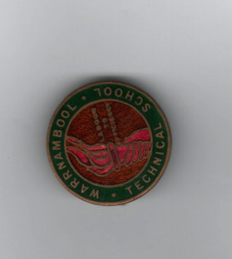 Warrnambool and District Historical Society Inc.
Badge, Warrnambool Technical school
... The latter institute moved to Sherwood Park, Warrnambool and became the present-day Warrnambool campus of Deakin University. Warrnambool Technical School moved to Caramut Road, Warrnambool and is today known as Brauer College. ...road This is a badge from Warrnambool Technical College in the 1930s. Warrnambool Technical School was established in Timor Street in 1913. The senior section was later called Warrnambool Technical College and then Warrnambool Institute of Advanced Education. The latter institute moved to Sherwood ...This is a badge from Warrnambool Technical College in the 1930s. Warrnambool Technical School was established in Timor Street in 1913. The senior section was later called Warrnambool Technical College and then Warrnambool Institute of Advanced Education. The latter institute moved to Sherwood Park, Warrnambool and became the present-day Warrnambool campus of Deakin University. Warrnambool Technical School moved to Caramut Road, Warrnambool and is today known as Brauer College. The badge came from Mirth Marfell, the daughter of Henry and Helena Marfell. She was born in Warrnambool in 1919. Her grandfather, John Marfell, a Warrnambool hay and corn dealer and miller connected to the Warrnambool Co-operative Milling Company, was prominent in community and civic affairs in the town. Mirth Marfell completed her nursing training at the Warrnambool Base Hospital and served in the Australian Army Nursing Service in World War Two for five years. She then became the first Australian nursing organizer for the Victorian Royal College of Nursing. The badge has also belonged at one stage to W Goodall a member of a well known Warrnambool family.This badge is of interest, firstly as a memento of Warrnambool Technical School from the 1920s and 30s and secondly because it came from Mirth Marfell, a Warrnambool person who had a distinguished nursing career.A circular metal and enamelled badge featuring a crimson torch and text on a bronze background surrounded by a dark green golden edged border with text. The reverse has a pin clip and text.WARRNAMBOOL. TECHNICAL..SCHOOL STOKES W GOODALLwarrnambool technical school, history of warrnambool, warrnambool institute of advanced education, deakin university campus, brauer college, mirth marfell, victorian royal college of nursing -
 Warrnambool and District Historical Society Inc.
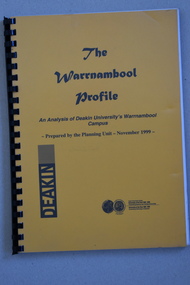
Booklet Lettering Book, Deakin University Planning Unit, The Warrnambool Profile – An Analysis of Deakin University’s Warrnambool Campus, 1999
... road This booklet was prepared in 1999 by the Planning Unit of Deakin University. It gives current data on the campus and projections and suggestions for the future. The Warrnambool Campus of Deakin University was established in 1990 after a merger with the Warrnambool Institute of Advanced Education which was already on the site that the university still occupies. This is Sherwood ...This booklet was prepared in 1999 by the Planning Unit of Deakin University. It gives current data on the campus and projections and suggestions for the future. The Warrnambool Campus of Deakin University was established in 1990 after a merger with the Warrnambool Institute of Advanced Education which was already on the site that the university still occupies. This is Sherwood Park, a 94 hectare site on the Princes Highway, five kilometres from Warrnambool.This booklet is of some interest as it contains information on the Warrnambool Campus of Deakin University ten years after it was first established. This is a soft cover booklet of 179 pages. It has an orange front cover and a black back cover with black printing and a plastic over-sheet. The booklet has printed information, tables and graphs. It has black plastic spiral binding. deakin university, warrnambool campus -
 Warrnambool and District Historical Society Inc.
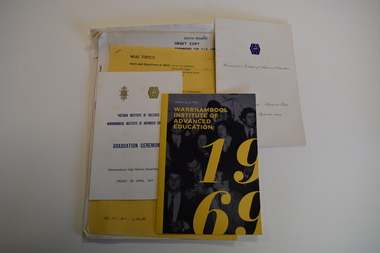
Administrative record (collection) - Warrnambool Institute of Advanced Education Collection, Second half of the 20th Century
... road This is a collection of W.A.I.E documents . The Institute was an offshoot of the Warrnambool Technical School founded in 1913. The Institute was established in 1969 and by 1984 it was fully established at the Sherwood Park Campus, East Warrnambool. ...Private CollectionHistorical RecordNo Particular OrderW.A.I.E Annual Reports, Student Magazines, Programs, Site Plans, Principal's Report, Various Bookletswarrnambool tertiary educationwarrnambool tertiary education -
 Warrnambool and District Historical Society Inc.
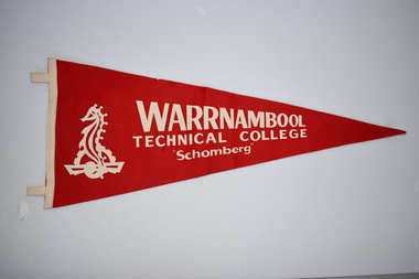
Pennant
... Road and is now called Brauer College. The senior section became the Institute of Adult Education and moved to Sherwood Park in 1984 , this is now Deakin University. and Timor Street is now Technical and Further Education. ...Road and is now called Brauer College. The senior section became the Institute of Adult Education and moved to Sherwood Park in 1984 , this is now Deakin University. and Timor Street is now Technical and Further Education. ...This pennant was used by one of the school houses at Warrnambool Technical College. Warrnambool Technical School was established in Warrnambool in 1913. The name was changed to Warrnambool Technical College in 1958. In 1974 the junior section of the Technical College was moved to Caramut Road and is now called Brauer College. The senior section became the Institute of Adult Education and moved to Sherwood Park in 1984 , this is now Deakin University. and Timor Street is now Technical and Further Education. The name of the house " Shomberg" comes from the ship that was wrecked near Peterborough, Victoria in 1855.This pennant is retained because of its connection with Warrnambool Technical School, an important educational establishment.A triangular red felt pennant with white felt loops for attaching to a stand. It has white printing and a white image of a sea horse stencilled on.WARRNAMBOOL TECHNICAL COLLEGE " Schomberg" -
 Warrnambool and District Historical Society Inc.
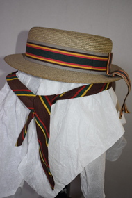
Hat & Neck Tie, Warrnambool Technical School, 1970s
... Sherwood Park in Warrnambool. The Timor Street site is now the location of South West College of TAFE. The WarrnamboolTechnical School moved from Timor Street to its present-day site in Caramut Road Warrnambool in 1973 and was re-named Brauer College in 1990 after Alfred Brauer, a Warrnambool doctor and a prominent school patron. ...road These two hats and school tie were once part of the uniform for girls at Warrnambool Technical School. This school was established in 1913 in Timor Street, Warrnambool with the first Principal being John King. From this school evolved the Warrnambool Institute of Advanced Education which itself was subsumed into the present day Deakin University campus at Sherwood Park in Warrnambool. ...These two hats and school tie were once part of the uniform for girls at Warrnambool Technical School. This school was established in 1913 in Timor Street, Warrnambool with the first Principal being John King. From this school evolved the Warrnambool Institute of Advanced Education which itself was subsumed into the present day Deakin University campus at Sherwood Park in Warrnambool. The Timor Street site is now the location of South West College of TAFE. The WarrnamboolTechnical School moved from Timor Street to its present-day site in Caramut Road Warrnambool in 1973 and was re-named Brauer College in 1990 after Alfred Brauer, a Warrnambool doctor and a prominent school patron. It is believed that the owners of the hats, Jeannie and Sandra Cole were sisters.These two hats and the tie are interesting reminders of the uniform of a local school some 40 or 50 years ago..1 This is a girl’s boater-shape straw hat. It has a ribbon band in grey, brown, yellow, red and green colours with a bow at the back with overhanging ends of the band. The hat has a cloth lining with a tag. The owner’s name is inside the hat. .2 This is a girl’s boater-shape straw hat. It has the same band as the one above but the crown on this hat is semi-detached. The owner’s name is on the inside of the hat. .3 This is a school tie. It is brown with gold, dark green and red diagonal stripes. .1 Jeannie Cole Made of straw fibre .2 Sandra Cole Made of straw fibre Created by Effie Jay showerproof with water repellent formula KO/3420 warrnambool technical school, history of warrnambool -
 Warrnambool and District Historical Society Inc.
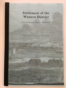
Booklet - Booklet: Settlement of the Western District, Collett, Bain and Gaspar, Printers, Settlement of the Western District From Prehistoric Times to the Present, 1985
... Warrnambool and District Historical Society Inc. 2 Gilles Street (south of Merri St) Warrnambool great-ocean-road This book, edited by Sherwood, Critchett and O’Toole, comprises the Proceedings of a Public Lecture Series held in Warrnambool, 3rd November 1984. ...This booklet documents a public lecture series held in Warrnambool 3rd November 1984.This is a soft-cover book of 133 pages on the settlement of the Western District from prehistoric times to the present. It has a blue paper front cover and a grey paper back cover. The front cover is covered with a clear plastic sheet and the binding is plastic. The cover has an image of a sketch of the Warrnambool beach showing the lighthouse complex on Middle Island and the lighthouse on the beach (established 1860). There are a Contents page, a Foreword, a List of Plates and seven articles on different aspects of the Western District history by different authors. There are black and white photographs and illustrations. One page (p.17) has been annotated by Les O’Callaghan.This booklet documents a public lecture series held in Warrnambool 3rd November 1984.western victorian history, edmund gill, peter ronald, john sherwood, jan critchett, tony dingle, miles lewis, kevin o’toole, warrnambool, history -
 Warrnambool and District Historical Society Inc.
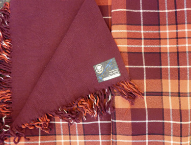
Textile - Woollen Blanket, Warrnambool Woollen Mill, Circa 1949
... Sherwood on the Hopkins River East Warrnambool who carried on the venture until fire destroyed the building in 1882, The site lay idle until a group of local businessmen raised 40000 pounds to establish the mill in 1910. It continued to trade well through the early and mid 20th century. Dunlop brought the mill in 1968 and there was a slow downturn with numerous owners until it closed in 2000. The site passed into private hands in 2003. Both the Warrnambool Woollen Mill and the Melbourne to Warrnambool Road ...The first Warrnambool to Melbourne cycling race was held in October 1895. 24 riders started with only 7 finishing the race. W. Nicol was the winner of the inaugural race. Two months later on 14/12/1895 the race was run in reverse. For the ensuing 43 years it was mainly Melbourne to Warrnambool. Since 1939 it has been run mainly Melbourne to Warrnambool. The prize of this blanket was 2nd prize to E. Ion of Tasmania in October 1949. The prize itself, A Warrnambool Blankets Tartan rug was made at the Warrnambool Woollen Mill in Harris St Warrnambool Early efforts to establish a woollen Mill in Warrnambool commenced with an early mill on the Merri at Woodford in 1874 but the site proved unsuitable and was financially struggling. The decision was made to move plant and and machinery to the old meat preserving factory in South Warrnambool The plant and equipment was sold to Mr Robert Hood of Sherwood on the Hopkins River East Warrnambool who carried on the venture until fire destroyed the building in 1882, The site lay idle until a group of local businessmen raised 40000 pounds to establish the mill in 1910. It continued to trade well through the early and mid 20th century. Dunlop brought the mill in 1968 and there was a slow downturn with numerous owners until it closed in 2000. The site passed into private hands in 2003.Both the Warrnambool Woollen Mill and the Melbourne to Warrnambool Road Race are a significant part of local history. The Melbourne to Warrnambool Cycling road race remains one of the premier sporting events in Australia. It commenced in 1895 Maroon and red block check with black and white check lines on front with plain maroon back. Fringed on two sides. Grey cotton label with The Warrnambool Woollen Mill Co Limited in top Left hand side of label, Victory Rug diagonally in blue Guaranteed All WOOL Made in Australia in bottom RH corner of label. Owner M bottom of label. 1949 Mr. Ernie Ion” handwritten in black pen.warrnambool, warrnambool woollen mill, marcus saltau, w. nicol -
 Warrnambool and District Historical Society Inc.
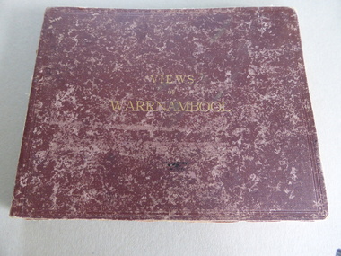
Album, Photographs Views of Warrnambool, c 1891
... Warrnambool and District Historical Society Inc. 2 Gilles Street (south of Merri St) Warrnambool great-ocean-road This album contains photographs of many Warrnambool buildings and scenes, including Proudfoot Boatsheds, St. John’s Church, Christ Church, Shelly Beach, Hopkins Falls, Sherwood gardens and buildings, Ozone Coffee Palace, Kepler Street, Sandstone Quarries and the Titan Crane on the Breakwater. ...This album contains photographs of many Warrnambool buildings and scenes, including Proudfoot Boatsheds, St. John’s Church, Christ Church, Shelly Beach, Hopkins Falls, Sherwood gardens and buildings, Ozone Coffee Palace, Kepler Street, Sandstone Quarries and the Titan Crane on the Breakwater. The photographs have been taken and put in album form by the photographer Joseph Jordan. The advertisements of the hotels on the inside covers place the publication of the album to the years1891-2. We have another album similar to this but there are six photographs in this album (VC000799) that are not in the other album. These extra photographs are of the original gardens and buildings of Sherwood.This is a most important album as the photographs are clear and show a good cross-section of Warrnambool in the early 1890s. Some of the photographs are not represented in other collections (eg Sherwood gardens) and so are of vital historical significance. The advertisements are also of great use to researchers.This album has a brown hard cover and contains three pages of local advertisements and sixteen pages of photographs and 32 photographs back to back. The pages have been bound but some pages have come loose. There is a fold-out section of a 180 degree panorama of Warrnambool taken from Liebig Street hill. The edges of these pages have been taped.Front Cover- Views of Warrnamboolwarrnambool, views of warrnambool, photos of warrnambool -
Glen Eira Historical Society
Ephemera - Carnegie Cricket Club
... Road... Bone J.... Jenner T.... Paul J.... Richards U.... Diamond C.... McKee W.... Reid S. H.... Robertson G.... Sherwood...Road Bone J. Jenner T. Paul J. Richards U. Diamond C. McKee W. Reid S. H. Robertson G. Sherwood J. ...This file contains nineteen Carnegie Cricket Club season match cards owned by the club’s Honorary Secretary for 1930-1931, and life member, Mr. T. E. S. Ash. The cards encompass the years from 1930-1931, 1936-1938, 1940-1941, 1943-1951 and 1952-1960. Each of the match cards list the office bearers for the year as well as the club’s fixtures. Some contain handwritten annotations by Mr. Ash as to the outcomes of the matches.ash mr., shelton j. n., reid s. h., price c., harratt f., stevenson h., donaldson t., walker a., cakebread e., gregg r., tebbs j., tempany t., quinn p., price f., lonch w., newing s., henderson e., reader a., larter f. t., harwood h., ash t. e. s., neerim road, bone j., jenner t., paul j., richards u., diamond c., mckee w., reid s. h., robertson g., sherwood j., tyers s. w., allaway j. e., clarke t. b., goldman a., jukes a., spencer w., beaumont c., carnegie, wishart g., bone r., boxshall k., cameron h., johnson a., hubbard l., larter f., price c. l., moore d., allaway e., ash t., louch w. h., goodall m., reid g., graham j., reid m., wilde w., willison p., murrumbeena, henty street, crussell j. a., williams h., allan p., pooley p. c., greig g., pierce l., caples r. w., newbury c. j., chamberlain a., cusack r., driver w. j., mau r., moore d. c., wishart m., pummeroy k., bailey f. i., brown r. w., whelan j. g., parker c., rofe r., wilkins d., dann e., tebbs j. (junior), yenden road, loush w., neville street, williams r. h., greenway a., lewis j., rolfe d., saunders r., wishart d., st. anthony, glenhuntly, stocks w., christie a., greenway a. e., caulfield south, ireland p., mcdougall c. j., burke s., pert r. g. a., mimosa road, carn. soc., carnegie socials, caulfield sth, ormond a, sweetnam r. w., price f. n., bone r. n., burke s. r., mcintosh a., ormond, caulfield east, ormond park, murrumbeena c, murrumbeena d, elsternwick, murrumbeena e, carnegie soldiers, mccarron a., newbury c. r., middleton j., o’connor j., cakebread j., morton l., lyons street, mckinnon, carnegie traders, bone r. j., north road, caul. f’balls, caulfield north, clarke t., whitelaw w., sweetman r. w., jury j., macfarlan i., daniells j. (senior), price r., bull a. j., tranmere avenue, wakeman o. w., coorigil road, bailey i., james p. c., ormond b, james p., pert r., green w., knox h., reid street, caulfield, heib j., price v. j., elliot a., phillips n., wilde w. j., cusack s., tyers n. s., hender b., george d., ford j., castles p., rolfe d. h., cusack r. s., gamble h., louch w. h., pearce e., koornang road, koornan road, harrington a., somerville h. j., grange road, sutherland m., bent street, rowland s., chestnut street, ariadne avenue, rankin ian, caulfield city, carnegie r. s. l., caulfield foot, murrumbeena foot, whitelaw m., chilvers r., kennedy d., mclatchie h., murrumbeena z, ormond c. of c., murrumbeena b, bentleigh, crussell j., mckee g., andrews e. j., andrews n., somerville h., moonya road, murrumbeena park, sweetnan r. w., hubbard l. c., harwood h. j., wilkins d. (senior), sporting clubs, cricket, clubs and associations, volunteers -
 Flagstaff Hill Maritime Museum and Village
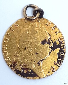
Currency - Guinea Coin, The Royal Mint, 1793 George III Spade Guinea, 1793
... Sherwood 12 Coin Collection of Notable Coinage of Australia. This coin is the only known guinea coin recovered from the wreck of the Loch Ard. It was already 85 years old when the ship was wrecked. Flagstaff Hill Maritime Museum and Village Warrnambool Great Ocean Road ...The coin was discovered by Julie Wilkins, a Victorian scuba diver who had already experienced more than 500 dives in Australia and overseas. She was holidaying in Peterborough, Victoria, and looking forward to discovering more about the famous Loch Ard ship, wrecked in June 1878 at Mutton Bird Island. The fast Glasgow-built clipper ship was only five years old when the tragedy occurred. There were 54 people on board the vessel and only two survived Julie's holiday photograph of Boat Bay reminds her of her most memorable dive. Submerged in the calm, flat sea, she was carefully scanning around the remains of the old wreck when, to her amazement, a gold coin and a small gold cross suddenly came up towards her. She excitedly cupped them in her hands, then stowed the treasures safely in her wetsuit and continued her dive. She soon discovered a group of brass carriage clock parts and some bottles of champagne. It was a day full of surprises. The items were easily recognisable, without any build-up of encrustations or concretion. Julie secretly enjoyed her treasures for twenty-four years then packed them up for the early morning train trip to Warrnambool. After a short walk to Flagstaff Hill Maritime Museum and Village, her photograph was taken as she handed over her precious find. She told her story to a local newspaper reporter, lunched a café in town then took the late afternoon train home. Her generous donation is now part of a vast collection of Loch Ard shipwreck artefacts, including the gold watch and the Minton Majolica model peacock. The coin is a British 1793 George III Gold Spade Guinea. It was already 83 years old when the Loch Ard had set sail. The loop and ring have been added, perhaps as a pendant, pocket watch accessory or similar purpose. It may have been worn for ‘good luck’ on the long journey to Australia, where ships had to carefully navigate the treacherous Bass’s Strait before arriving at their destination of Melbourne. Sadly, many met their fate on that short stretch of ocean aptly named the Shipwreck Coast. The coin is very recognisable even though it was exposed to the wrecking of the ship, its consequent movement, and the sea's turbulence. Its bent, scratched, buckled, split, dinted and worn condition is part of its story. The red-brown-black discolouration is similar to that found on other gold coins, sometimes called the ‘corrosion phenomena’. Studies suggest the possible cause is contaminants in the minting process reacting to the coins’ environment. The GEORGE III GOLD SPADE GUINEA: - The British Guinea was introduced in 1663 and was circulated until 1814. It was made of 22 carat gold, was 25 to 26 cm in diameter and weighed 8.35 grams. It had a value of 21 British shillings. The guinea coin ceased circulation after 1816 and was replaced by the one-pound note. However, the term ‘guinea’ continued to represent 21 shillings. King George (1738-1820) had six gold guinea designs minted during his reign from 1760 and 1820. Each of the six had different obverse portraits, all facing the right. There were three different reverse sides. The Spade Guinea was the fifth issue of the coin, introduced in 1787 and produced until 1799. The reverse shows a royal crown over a flat-topped shield with the Royal Arms of Great Britain, used in Scotland between 1714 and 1800. The shield images are, from left to right, top to bottom, the Arms of England and Scotland, the Arms of France, the Arms of Ireland, and the Arms of the House of Hanover. The Gold Guinea is also part of Australia’s history. It was the first coin mentioned in the announcement of Governor King of New South Wales his Australian Proclamation of a limited variety and denomination of coins accepted for use in the Australian Colony. The historic and decorative George III Spade Guinea has been reproduced for special collections of coins. However, replicas and imitations have also been made as souvenirs for tourists, as gaming tokens and chips for gamblers, and as ‘fake’ coins for profit. These coins differ in many ways; they may be only half the weight of the genuine coin. Often have a small stamp on the obverse with “COPY” or the manufacturer’s name or initials. Some have scalloped edges, some have dates that are different to the original dates of issue, and some even have text in Latin that translates as something very different to the original coin.The King George III Guinea was only produced from 1663 to 1814 and was the first English coin to be mechanically minted. The coin is the fifth edition of the King George III Guinea, the Spade Guinea, was only produced between 1787 and 1799. It is the only edition with this portrait of King George and the only one with the Royal Coat of Arms of Great Britain in Scotland on the reverse side. This edition was also the last guinea in circulation, because the sixth edition was reserved as the Military guinea. This edition of the Guinea is unique; This coin is the only guinea in our collection. It was minted in 1793, so it is now over 230 years old. The Gold Guinea is part of Australia’s history; it was the first coin in the list of coins for use in the Australian Colonies, mentioned by Governor King of New South Wales in his Australian Proclamation speech of 1800. The George III Spade Guinea was included in the Limited Edition Sherwood 12 Coin Collection of Notable Coinage of Australia. This coin is the only known guinea coin recovered from the wreck of the Loch Ard. It was already 85 years old when the ship was wrecked.Gold coin; British. 1793, King George III of the United Kingdom of Great Britain and Ireland (1760-1820), Spade Guinea. Yellow gold coin with gold metal loop mount and a gold ring through the loop. The design is the fifth issue of the George III Gold Guinea. The obverse relief is a portrait of George III facing right. Reverse relief is a crown above the Coats of Arms (1801-1816) of flat top spade-shaped shield divided into four quadrants that depict crowned lions, fleur de lies, a harp. These images are identified as, from left to right, top to bottom, England and Scotland, France, Ireland and Hanover. Inscriptions are minted around the rims of each side. The coin is dated 1793. Its surface has dark areas on both sides and the reed edge and surfaces are well worn. The loop mount is bent and the ring is buckled. The coin was recovered from the wreck of the ship Loch Ard.Obverse text; 'GEORGIVS III DEI GRATIA' (translates to George the Third, by the Grace of God) Obverse relief; (King George III bust, facing right, laurel wreath on head) Reverse text; 'M.B.E.ET.H.REX.F. D.B.ET.L.D. S.R.I.A.T.ET.E' '1793' (translates to: King of Great Britain, France and Ireland, Defender of the Faith, Duke of Brunswick and Lüneburg, Arch-Treasurer and Elector of the Holy Roman Empire) Reverse relief; a spade-shaped image i.e. (Crown with fleer de lies, above Shield with crowned lions in different postures, a harp, and other details)flagstaff hill maritime museum and village, warrnambool, great ocean road, shipwreck coast, royal mint, british coin, currency, guinea, military guinea, australian currency, british guinea, gold coin, spade guinea, king george iii, george iii, fifth portrait, arms of england and scotland, arms of france, arms of ireland, arms of the house of hanover, coins, gold coins, gold medallion, georgian era, 1793, numismatics, contamination phenomena, gold corrosion, good luck, lucky charm, pendant, lucky coin, trade, loch ard, wreck of the loch ard, 1878, mutton bird island, peterborough, scuba diver, 1980s, guinea coin, gold guinea, shipwreck artefact, relic, julie wilkins -
 Ringwood and District Historical Society
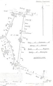
Document - Copy of Lands Department Field Notes - Parish of Ringwood, Victoria, Field Notes 55114 Survey of Allotment by J.D. Sherwood in 1955
... References include Railway (Reserve), Education Department, A-B Datum 117degrees20', Bedford Road, Certification by J.D. Sherwood Licensed Surveyor 23/11/1955....References include Railway (Reserve), Education Department, A-B Datum 117degrees20', Bedford Road, Certification by J.D. Sherwood Licensed Surveyor 23/11/1955. ...5618b Foolscap size photocopy of survey map with handwritten notations. References include Railway (Reserve), Education Department, A-B Datum 117degrees20', Bedford Road, Certification by J.D. Sherwood Licensed Surveyor 23/11/1955. -
 Flagstaff Hill Maritime Museum and Village
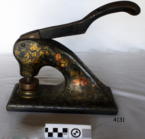
Functional object - Hand operated embossing document press, 1910
... road The woollen mill was a vital part of Warrnambool for all but 22 years of the town’s history since it's the establishment in 1847 when the first land sales were held and white settlement began. In 1869 the Warrnambool Meat Preserving Company began operations on the mill site, in 1875, shareholders of the then defunct Warrnambool Meat Preserving Company happily sold the land and buildings on the Merri river to Warrnambool Woollen Mill Company Ltd for £5,000. The site was sold again in 1876 to grazer Robert Hood of Sherwood ...The woollen mill was a vital part of Warrnambool for all but 22 years of the town’s history since it's the establishment in 1847 when the first land sales were held and white settlement began. In 1869 the Warrnambool Meat Preserving Company began operations on the mill site, in 1875, shareholders of the then defunct Warrnambool Meat Preserving Company happily sold the land and buildings on the Merri river to Warrnambool Woollen Mill Company Ltd for £5,000. The site was sold again in 1876 to grazer Robert Hood of Sherwood, who was chairman of directors of the failed company, which couldn’t raise sufficient capital to keep the works operating. The entrepreneurial Hood then used the existing plant to turn his own wool into tweed cloth. But just as the mill was starting to show a profit, a fire destroyed the building and plant on the night of 25 March 1882. So again, the mill was operational for six short years. Insurers only paid a fraction over 10% of the damage, Hood couldn't raise sufficient capital to rebuild on his own, and so the site lay unused until 1910. In 1908 Marcus Saltau and Peter John McGennan convinced the Warrnambool Chamber of Commerce to invest in a secondary industry with local capital. A public meeting in September 1908 agreed to raise £40,000, electing Saltau chairman of directors, a post he held for 34 years. A year later, using mostly local money, the Warrnambool Woollen Mill Company dispatched its first manager, John E. Bennett, to buy a plant and recruit 20 experienced staff from the Yorkshire woollen industry in December 1909. Another year more, the new mill was officially opened on 14 November 1910 by Marcus Saltau as company chairman and town mayor. Eighteen months on, in May 1912, the mill paid its first half-yearly dividend of 2 ½%. It was now working two shifts, with a year's orders to fill. In 1914 the mill ordered its own generator, providing the town with electricity and effectively doubling its plant size by October 1915, six months after Gallipoli. Thereafter, government orders for cloth and military supplies assured the mill’s success right through the First World War and on until 1923. A plant upgrade in 1922 for machinery to make worsted fabric drained profits, which, with a fall in demand, led to a loss in 1925. Profits were restored by the 1930s, despite the Depression, mostly due to tight management and robust marketing. Production boomed again during the Second World War, but soon foreign competition bit into profits, forcing the company to consolidate operations. The ‘50s and ‘60s were golden years for the mill. Security and growth gave the company confidence to trial Australia’s first electric blanket in 1958 and to install Swiss Sulzer looms in 1965. Over time, the building facades took on the modern look that the mill presented until it closed. The Dunlop company bought the mill in 1968, fending off a challenge from Onkaparinga in South Australia, and continued to expand by adding Wendouree Woollen Mill in the same year and Dream-spun Textiles a decade later, in 1979. Soon after that purchase, however, the mill began its slippery slide into decline. Dunlop sold to its former rival bidder Onkaparinga Woollen Co. Ltd in 1982, which in turn was taken over by Macquarie Worsted's only a year later, in 1983. Operations remained stable for a decade until 1994 when the Macquarie Group signaled that its newly rationalised operations left no room for the Warrnambool investment. The final operator of the mill was The Smith Family charity group, which ran the site by agreement with the Warrnambool City Council and a state government grant in that same year, 1994. The mill became more of a fabric recycler than a manufacturer. The site was sold to private operators in February 2003 and rezoned four months later to allow for the mixed housing development. The embossing press is significant for its association with the Warrnambool Woollen Mills 1910-1968, a major employer in the Warrnambool district. The press is also significant as an example of commercial office equipment used in the 19th and 20th century.Press, metal, for Company seal of Warrnambool Woollen Mill, stamping their brand as Western District Worsted Mills Pty Ltd. Metal is black with red and gold floral markings. Inscription of stamp reads "WESTERN DISTRICT WORSTED MILLS PROPRIETRY LIMITED" flagstaff hill, warrnambool, shipwrecked-coast, flagstaff-hill, flagstaff-hill-maritime-museum, maritime-museum, warrnambool woollen mills, western district worsted mills proprietry limited, worsted fabric, printing press, logo printing press, stamp printing press, shipwreck-coast, flagstaff-hill-maritime-village