Showing 813 items matching "shire avenue"
-
 Federation University Historical Collection
Plan, Plan of Mount Helen, 7/7/1964
... ...shire avenue...Chatham Ave midland highway gear avenue eddy avenue shire avenue boak avenue moss avenue rathkeale avenue ingliston avenue chatham avenue mardango drive nyora grove yarana drive shakespeare avenue marina avenue landale avenue lylia avenue recreation road olympic avenue the gums heather avenue dallas avenue jones avenue sebastopol mount clear road Plan of Subdivisions to Mount Helen, Shire of Buninyong, Sheet 1 and Sheet 2 Scale 200 feet to one inch Plan of Mount Helen Plan Plan K. ...John [Jack] and Jessie Imogene[ Gene] Chatham purchased a subdivided property in Mount Helen. Chatham Ave Plan of Subdivisions to Mount Helen, Shire of Buninyong, Sheet 1 and Sheet 2 Scale 200 feet to one inchmidland highway, gear avenue, eddy avenue, shire avenue, boak avenue, moss avenue, rathkeale avenue, ingliston avenue, chatham avenue, mardango drive, nyora grove, yarana drive, shakespeare avenue, marina avenue, landale avenue, lylia avenue, recreation road, olympic avenue, the gums, heather avenue, dallas avenue, jones avenue, sebastopol mount clear road -
 Federation University Historical Collection
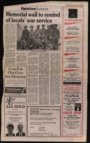
Newsclip, Ballarat Courier, Memorial Wall to Remind of Locals' War Service, 1993, 17/07/1993
... ...ballarat shire avenue of honour...Barker Library (top floor) Mount Helen goldfields anzac world war one memorial avenue of honour ballarat shire ballarat shire avenue of honour chatham-holmes family collection Newsclip on Ballarat memorial wall for those who served during World War One. ...Newsclip on Ballarat memorial wall for those who served during World War One.anzac, world war one, memorial, avenue of honour, ballarat shire, ballarat shire avenue of honour, chatham-holmes family collection -
 Phillip Island and District Historical Society Inc.
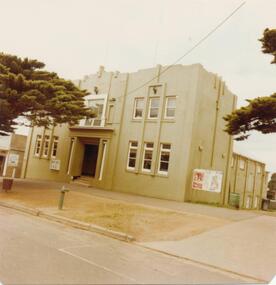
Photograph, 1978/79
... Shire Hall in Thompson Avenue, Cowes. Built early 1930's. ...Shire Hall in Thompson Avenue, Cowes. Box like building with windows overlooking the street. ...Phillip Island and District Historical Society Inc. phillip-island-and-the-bass-coast Shire Hall in Thompson Avenue, Cowes. Built early 1930's. ...Shire Hall in Thompson Avenue, Cowes. Built early 1930's. Demolished 1984/1985. The Shire Hall was also used as a Picture Theatre and Ballroom catering for 200 persons. On the right hand side was the Library which later was moved downstairs. The Council Chambers were on the third floor.Shire Hall in Thompson Avenue, Cowes. Box like building with windows overlooking the street. Note entrance at the middle of the building - also the Notice Board on the right advertising the forth coming films. The building was on three levels. Note Balcony above front door in the middle of the building.local history, photographs, historic, buildings - historical, coloured photograph, john cook, phillip island, cowes shire hall -
 Phillip Island and District Historical Society Inc.
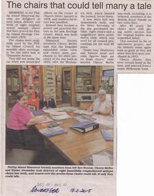
Newspaper Clipping, San Remo & Phillip Island Advertiser, Museum Chairs restored, 18/2/2015
... The chairs together with a large table originally were used by the Phillip Island Council for monthly shire meetings in the old shire hall in Thompson Avenue. When the new offices opened on the corner of Church Street & Thompson Avenue in 1978 modern furniture was installed. ...Phillip Island and District Historical Society Inc. phillip-island-and-the-bass-coast The chairs together with a large table originally were used by the Phillip Island Council for monthly shire meetings in the old shire hall in Thompson Avenue. When the new offices opened on the corner of Church Street & Thompson Avenue in 1978 modern furniture was installed. ...The chairs together with a large table originally were used by the Phillip Island Council for monthly shire meetings in the old shire hall in Thompson Avenue. When the new offices opened on the corner of Church Street & Thompson Avenue in 1978 modern furniture was installed. They were then donated to the Historical Society. Article and photo of Bev Forrest, Cherry McFee & Elaine Alexander sitting on the newly reupholstered antique chairs in the museum. museum chairs and table, chairs restoration, cherry mcfee, bev forrest, elaine alexander, phillip island & san remo advertiser, shire of phillip island -
 Ballarat Clarendon College
Albert Telfer White (1918) collection
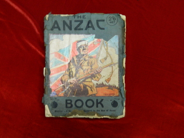
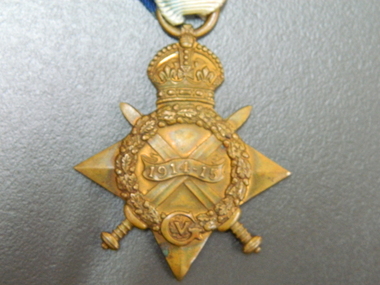
... Albert Telfer White's sacrifice is commemorated at Ballarat College, Avenue of Honour Ballarat (Tree 1214), Ballarat Shire Honour Avenue Learmonth (Tree 163) and the Australian War Memorial Canberra. ...Albert Telfer White's sacrifice is commemorated at Ballarat College, Avenue of Honour Ballarat (Tree 1214), Ballarat Shire Honour Avenue Learmonth (Tree 163) and the Australian War Memorial Canberra. ...Significant items relating to Albert Telfer White who entered Ballarat College April 1912 and left December 1918. Albert was born 29 June 1897 at his home 'Ashford Vale" farm, Cuthbert's Road, Cardigan. Albert, a second generation Australian, was the fourth son and sixth of eleven children born to dairy farmer John White and his wife Elizabeth, nee Douglas. Albert attended Bunker's Hill State School prior to enrolling at Ballarat College. After College he obtained employment with the engineering firm Ronaldson and Tippett in Ballarat. Following his eighteenth birthday Albert enlisted in the AIF in Ballarat with the rank of Private, No 2012. He embarked for the Middle East with 23rd Battalion on 26 August 1915 and was 'taken on strength at the Gallipoli Peninsular 25 October 1915". On 10 January 1916 Albert was posted to Alexandria, Egypt and during this time he was able to meet with his aunt Rose Douglas, an Australian Army Nursing Sister. This was a great comfort to his family. Albert was sent to France 19 March 1916 and transferred to the 22nd Battalion. He was mentioned in dispatches for 'good and gallant conduct' 5 August (1917?). Albert was hospitalised 30 March 1918, rejoined 22nd Battalion 3 June 1918, wounded in action 3 October 1918 but died of wounds at Rouen 10 October 1918. news of his death was received by his family n Australia just prior to the armistice. Albert Telfer White's sacrifice is commemorated at Ballarat College, Avenue of Honour Ballarat (Tree 1214), Ballarat Shire Honour Avenue Learmonth (Tree 163) and the Australian War Memorial Canberra. (These notes provided by family November 2016)Collections of items including: Bayonet, Carl Eickhorn, Solingen, (29.A.159 engraved on handle) Trench shovel The ANZAC book 1916 (flyleaf inscribed: No 2012 / Pte A T White / H Quarters / 22nd Battalion / 6th Inf Brigade / France) Gallipoli medal with documentation First World War Mothers’ and Widows’ Badge Next of Kin Memorial Plaque (Death Penny) and accompanying letter from King George V Imperial War Graves Commission documentation and photograph Australia Graves Services In Memory card and photograph Documentation relating to Australian War Memorial Roll of Honour, Learmonth Memorial Wall, Ballarat and Learmonth Avenues of Honours Documentation from the Australian Army Records office Documentation relating to Military Medal, 1914/15 Star, British War Medal and Victory Medal (whereabouts unknown, November 2016) Portraiture of Albert Telfer White as a child, as a young adult (civilian dress), in full kit (A I E F formal), and at camp 1915 Portraiture of sisters Cis, Addie, Bessie, Evelyn (with personal inscriptions) Four postcards (one with letter from Albert ‘at sea’ to his mother - undated) Death notice (unreferenced newspaper clipping) Biographical and family relationship details Photocopy of The White Family 1906 showing (standing) Adeline, Leslie, Harold (father), Muriel (mother), William; (seated) Albert, John (Grandfather), Elizabeth, Allan, Elizabeth (Grandmother), Evelyn (baby) and Benjamin The ANZAC book 1916 (flyleaf inscribed: No 2012 / Pte A T White / H Quarters / 22nd Battalion / 6th Inf Brigade / France) Gallipoli medal: engraved on reverse: A T WHITE Embossed lettering on death penny: ALBERT TELFER WHITE Handwritten on reverse of portraits: Lovingly yours / Cis / 21/11/17; your / loving sister / Addie; your loving / sister / Evelyn; Yours lovingly / Bessie Handwritten on back of postcard of ship H M A T 'Anchisis' 14.3.16: Dear Mother, I am sending you a card / of the boat we are on. Our deck is right / on the back. I have marked it with an X. / We are not allowed to put the date on or / where we are. I am sitting on the deck now / holding the card in my hand so it is hard / to write. We are together yet haven't been / separated Bill, Matt and myself. Haven't / had anything to do. I will write a couple / of letters now. Albert Handwritten on back of postcard photograph of Albert at camp: 30th September 1915 / Dear Mother / There is a studio at the / camp so Matt and I got our Photos / taken yesterday morning, & got them/ this morning. I am sending / Ciss one of Matt.albert-telfer-white, ballarat college, world-war-one, avenue-of-honour -
 Ballarat Clarendon College
Medal, 1914-15 Star
... Albert Telfer White's sacrifice is commemorated at Ballarat College, Avenue of Honour Ballarat (Tree 1214), Ballarat Shire Honour Avenue Learmonth (Tree 163) and the Australian War Memorial Canberra. ...Albert Telfer White's sacrifice is commemorated at Ballarat College, Avenue of Honour Ballarat (Tree 1214), Ballarat Shire Honour Avenue Learmonth (Tree 163) and the Australian War Memorial Canberra. ...The 1914–15 Star was authorised in 1918 and was awarded for service in specified theatres of war between 5 August 1914 and 31 December 1915. A recipient of the 1914 Star could not also be awarded the 1914–15 Star. Albert was born 29 June 1897 at his home 'Ashford Vale" farm, Cuthbert's Road, Cardigan. Albert, a second generation Australian, was the fourth son and sixth of eleven children born to dairy farmer John White and his wife Elizabeth, nee Douglas. Albert attended Bunker's Hill State School prior to enrolling at Ballarat College. After College he obtained employment with the engineering firm Ronaldson and Tippett in Ballarat. Following his eighteenth birthday Albert enlisted in the AIF in Ballarat with the rank of Private, No 2012. He embarked for the Middle East with 23rd Battalion on 26 August 1915 and was 'taken on strength at the Gallipoli Peninsular 25 October 1915". On 10 January 1916 Albert was posted to Alexandria, Egypt and during this time he was able to meet with his aunt Rose Douglas, an Australian Army Nursing Sister. This was a great comfort to his family. Albert was sent to France 19 March 1916 and transferred to the 22nd Battalion. He was mentioned in dispatches for 'good and gallant conduct' 5 August (1917?). Albert was hospitalised 30 March 1918, rejoined 22nd Battalion 3 June 1918, wounded in action 3 October 1918 but died of wounds at Rouen 10 October 1918. news of his death was received by his family in Australia just prior to the armistice. Albert Telfer White's sacrifice is commemorated at Ballarat College, Avenue of Honour Ballarat (Tree 1214), Ballarat Shire Honour Avenue Learmonth (Tree 163) and the Australian War Memorial Canberra. (These notes provided by family November 2016)Part of a greater A T White CollectionThe 1914-15 Star is a four pointed star of bright bronze, ensigned with a crown. The obverse has crossed gladius, overlaid with an oak wreath that is ensigned with the cypher of King George V. A scroll bearing the legend 1914-15 is centrally placed across the crossed blades. The 1914-15 Star ribbon has the red white and blue colours of the Empire, in shaded and watered stripes.Engraved on a scroll in the centre of the medal front: '1914-15' The oak wreath is ensigned with the cypher of King George V. The back of the medal is engraved: 2012 / Pte A T White / 23/BN. A.I.F. albert-telfer-white, medal, world war one, 1914-15 star -
Clunes Museum
Document - ARTHUR JAMES ROBERTS
... Black and white photocopies .1 Photocopy of Keith Roberts and Arthur Lloyd Roberts standing beside the Shire of Ballarat Honour Avenue 1914-18 monument with a close up of the roll for WWI and the name of A J Roberts (their father) .2 Photocopy image of A J Roberts in uniform for WWI, Newspaper article in the Ballarat Star, Tuesday March 25 1918 reporting Pte. ...Clunes Museum 36 Fraser Street enter building through Collins Place Clunes goldfields A J Roberts enlisted to serve in WW1 A J ROBERTS WW1 Black and white photocopies .1 Photocopy of Keith Roberts and Arthur Lloyd Roberts standing beside the Shire of Ballarat Honour Avenue 1914-18 monument with a close up of the roll for WWI and the name of A J Roberts (their father) .2 Photocopy image of A J Roberts in uniform for WWI, Newspaper article in the Ballarat Star, Tuesday March 25 1918 reporting Pte. ...A J Roberts enlisted to serve in WW1 Black and white photocopies .1 Photocopy of Keith Roberts and Arthur Lloyd Roberts standing beside the Shire of Ballarat Honour Avenue 1914-18 monument with a close up of the roll for WWI and the name of A J Roberts (their father) .2 Photocopy image of A J Roberts in uniform for WWI, Newspaper article in the Ballarat Star, Tuesday March 25 1918 reporting Pte. A Roberts attendance at the unveiling of the Honor Roll at the Tourello School of past students. Copy of service card No. 4874 (handwritten) Corp. A J Roberts and copy of what appears to be photograph of A J Roberts with his unit. .3 Photocopy of a diary of his movements, kept by Arthur James Roberts in his own handwriting from enlistment July 23 1915 (some of this is illegible)a j roberts, ww1 -
 Kiewa Valley Historical Society
Photographs – Lakeside Avenue, Mt Beauty. Circa 1993. Set of 7 colour photographs
... It also demonstrates the attention paid by Alpine Shire towards providing accessible recreational green space around the town centre. Mt Beauty Lakeside Ave Mt Beauty No markings Set of 7 colour photographs of Lakeside Avenue, Mt Beauty. ...Established in 1946, during the construction of the Kiewa Hydro Electric Scheme, the township of Mt Beauty was developed by the State Electricity Commission of Victoria to provide additional accommodation for the thousands of workers during the construction of the country’s second largest hydro-electricity scheme. Although these towns were built as temporary accommodation for the workers and their families, many stayed after the scheme finished. Combined with the influx of European migrants, with their rich cultural backgrounds, all played a major part in shaping the future character of the Mount Beauty, the Kiewa Valley and Falls Creek. The Bright Council, now the Alpine Shire took over the control of the township in 1960. This relatively young town of Mount Beauty, along with the surrounding townships of Falls Creek, Bogong, Tawonga South and Tawonga, are all part of a prospering tourist area with excellent services, accommodation, food and a wide range of recreational activities available for all ages. According to Shire records, the population of Mt Beauty has grown from 1,500 in 1981 to 1,800 in 2016 with a projected increase to 2,000 in 2013The photographs taken around 1993 show a prosperous commercial centre catering for both locals and the needs of visitors. It provides a pictorial history of the changes which have occurred in the retail/commercial district of Mt Beauty over the years. It also demonstrates the attention paid by Alpine Shire towards providing accessible recreational green space around the town centre.Set of 7 colour photographs of Lakeside Avenue, Mt Beauty. Circa 1993 showing retail services and streetscape of the time. No markingsmt beauty, lakeside ave mt beauty -
 Emerald Museum & Nobelius Heritage Park
Photograph - Emerald Main Street, 1907
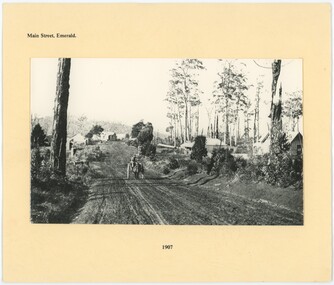
... According to Old Ferntree Gully Shire History, the man in the horsecart is David Charman, early Emerald resident and namesake of Charman Avenue. ...According to Old Ferntree Gully Shire History, the man in the horsecart is David Charman, early Emerald resident and namesake of Charman Avenue. ...This photograph depicts Emerald Main Street in 1907, still unpaved and traversed by horses more than cars. Mr. W. Moffat's general store is in the background on the right. The year after this photograph was taken, bushfires would threaten Moffat's store, (along with other stores and homes, on top of the church and the railway sleepers) which was ignited several times but not destroyed. According to Old Ferntree Gully Shire History, the man in the horsecart is David Charman, early Emerald resident and namesake of Charman Avenue. This is a copy of an original; part of a stamp on an older copy is cut off in the top right of the photograph. Additionally, another copy of this photograph is in our collection.This photograph captures a much earlier Emerald Main Street, almost unrecognisable today.A black and white photograph at the center of a labelled card backing. The photograph depicts a wide dirt road, with a horse and cart traversing the center of the road. There are buildings - mostly shops - on either side, amidst trees. A hill rises in the background.Top: "Main Street, Emerald" Bottom: "1907"emerald, 1900s, commerce -
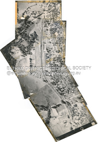
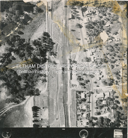
 Eltham District Historical Society Inc
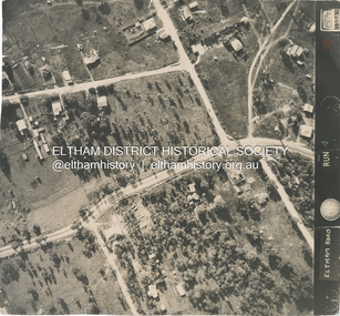
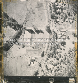
Photograph - Aerial Photograph, Main Road, intersection Grand Boulevard and Panorama Avenue, Lower Plenty / Montmorency, 2 Jul. 1951
... shire of eltham archives...Aerial Photo...Country Roads Board...Eltham...Main Road...Road widening...1951-07...Airlie Road...Ambulance Station...Beleura Grove...Grand Boulevard...Looker Road...Lower Plenty...Montmorency...Panorama Avenue...Eltham District Historical Society Inc 728 Main Rd Eltham melbourne Not originally catalogued in Shire of Eltham Archives but from the same series of photos taken for Country Road Board study of Main Road widening shire of eltham archives Aerial Photo Country Roads Board Eltham Main Road Road widening 1951-07 Airlie Road Ambulance Station Beleura Grove Grand Boulevard Looker Road Lower Plenty Montmorency Panorama Avenue Black and white proto print Size: 245x230 mm Condition: good Main Road, intersection Grand Boulevard and Panorama Avenue, Lower Plenty / Montmorency Photograph Aerial Photograph ...Not originally catalogued in Shire of Eltham Archives but from the same series of photos taken for Country Road Board study of Main Road wideningshire of eltham archives, aerial photo, country roads board, eltham, main road, road widening, 1951-07, airlie road, ambulance station, beleura grove, grand boulevard, looker road, lower plenty, montmorency, panorama avenue -
 Eltham District Historical Society Inc
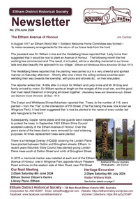
Journal - Newsletter, Newsletter, No. 276 June 2024
... Eltham District Historical Society Inc 728 Main Rd Eltham melbourne Contents: • The Eltham Avenue of Honour by Jim Connor • Next Meeting –2.00pm Saturday 8th June 2024 • July Excursion - Saturday 6th July – Walter Withers Walk • Robert Hoddle – Chains and Grids in Terra Nullius by Anne Paul • Montsalvat People by Richard Pinn o Arthur Munday (1903-1976) o Sonia Skipper (1918-2008) • Arthur Egglestone Dungey, Eltham’s third policeman by Irene Kearsey • Annual General Meeting – Saturday 13th April 2024 • Flagging Appreciation by Terry Beaton • Eltham Cemetery Stories by Liz Pidgeon o Blanche Emily Shallard, nee Everard, 1905-2002. Local historian and community volunteer • Experience Eltham Cemetery The Shire ...Contents: • The Eltham Avenue of Honour by Jim Connor • Next Meeting –2.00pm Saturday 8th June 2024 • July Excursion - Saturday 6th July – Walter Withers Walk • Robert Hoddle – Chains and Grids in Terra Nullius by Anne Paul • Montsalvat People by Richard Pinn o Arthur Munday (1903-1976) o Sonia Skipper (1918-2008) • Arthur Egglestone Dungey, Eltham’s third policeman by Irene Kearsey • Annual General Meeting – Saturday 13th April 2024 • Flagging Appreciation by Terry Beaton • Eltham Cemetery Stories by Liz Pidgeon o Blanche Emily Shallard, nee Everard, 1905-2002. Local historian and community volunteer • Experience Eltham Cemetery The Shire of Eltham Historical Society was formed in October 1967. The first newsletter of the Society was issued May 1978 and has been published continuously ever since on a bi-monthly basis. With the cessation of the Shire of Eltham in late 1994, the Society's name was revised to Eltham District Historical Society and this name first appeared with issue No. 103, July 1995. The collection of the Society's newsletters provides a valuable resource on the history of the Society's activities, office bearers and committee members, guest speakers and subjects of historical interest pertinent to the former Shire of Eltham and the Eltham District.A4 newsletter distributed to members (Digital and A4 photocopy)newsletter, eltham district historical society -
 Eltham District Historical Society Inc
Photograph - Digital Photograph, Alan King, Little Bank Building, the former Commercial Bank of Australia Branch, Hurstbridge, 1 February 2008
... Avenue, formerly a Commercial Bank of Australia branch, was moved to Hurstbridge around 1917. It was one of a few portable branch buildings, towed by horse or bullock team to a site as required. The branch operated until the early 1980s. In 1985 it was moved about 42 metres south to the Allwood House grounds to become part of the Hurstbridge Neighbourhood House. Covered under Heritage Overlay, Nillumbik Planning Scheme. Published: Nillumbik Now and Then / Marguerite Marshall 2008; photographs Alan King with Marguerite Marshall.; p13 This collection of almost 130 photos about places and people within the Shire ...The Little Bank Building at the corner of Anzac Avenue, formerly a Commercial Bank of Australia branch, was moved to Hurstbridge around 1917. It was one of a few portable branch buildings, towed by horse or bullock team to a site as required. The branch operated until the early 1980s. In 1985 it was moved about 42 metres south to the Allwood House grounds to become part of the Hurstbridge Neighbourhood House. Covered under Heritage Overlay, Nillumbik Planning Scheme. Published: Nillumbik Now and Then / Marguerite Marshall 2008; photographs Alan King with Marguerite Marshall.; p13This collection of almost 130 photos about places and people within the Shire of Nillumbik, an urban and rural municipality in Melbourne's north, contributes to an understanding of the history of the Shire. Published in 2008 immediately prior to the Black Saturday bushfires of February 7, 2009, it documents sites that were impacted, and in some cases destroyed by the fires. It includes photographs taken especially for the publication, creating a unique time capsule representing the Shire in the early 21st century. It remains the most recent comprehenesive publication devoted to the Shire's history connecting local residents to the past. nillumbik now and then (marshall-king) collection, cba bank, commercial bank of australia, hurstbridge, little bank building, portable buildings -
 Eltham District Historical Society Inc
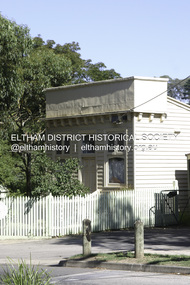
Slide, Site for the new Apex-Diamond Valley Ambulance Station, corner of Main Road and Grand Boulevard, Montmorency, July 1969, 1969
... Avenue, Montmorency showing the site for the new Apex-Diamond Valley Ambulance Station and before construction of Apex Way, July 1969. The Eltham Apex Club conducted a Community Service Project (1965-1968) to raise funds for a new Ambulance Station to service the community. A site bounded by the intersection of Main Road, Grand Boulevard and Looker Road at Montmorency was purchased in 1969. In 1970, Eltham Shire...Avenue, Montmorency showing the site for the new Apex-Diamond Valley Ambulance Station and before construction of Apex Way, July 1969. The Eltham Apex Club conducted a Community Service Project (1965-1968) to raise funds for a new Ambulance Station to service the community. A site bounded by the intersection of Main Road, Grand Boulevard and Looker Road at Montmorency was purchased in 1969. In 1970, Eltham Shire ...View looking west along Grand Boulevard from the intersection with Main Road and Panorama Avenue, Montmorency showing the site for the new Apex-Diamond Valley Ambulance Station and before construction of Apex Way, July 1969. The Eltham Apex Club conducted a Community Service Project (1965-1968) to raise funds for a new Ambulance Station to service the community. A site bounded by the intersection of Main Road, Grand Boulevard and Looker Road at Montmorency was purchased in 1969. In 1970, Eltham Shire Council undertook roadworks to construct Apex Way in preparation for the new station as well as duplicate Main Road, Lower Plenty, east of Grand Boulevard including the new Lower Plenty Bridge, which had been opened in November 1966, bordering with the City of Heidelberg.35 mm colour positive transparency Mount - Agfacolor Service (Blue)1969-07, ambulance station, apex way, grand boulevard, lower plenty, main road, montmorency, eltham ambulance station, apex-diamond valley ambulance station, eltham apex club -
 Eltham District Historical Society Inc
Slide, Reconstruction of Grand Boulevard viewed from Panorama Avenue, Montmorency, 18 August 1970, 1970
... In 1970, Eltham Shire Council undertook roadworks to construct Apex Way in preparation for the new station as well as duplicate Main Road, Lower Plenty, east of Grand Boulevard including the new Lower Plenty Bridge, which had been opened in November 1966, bordering with the City of Heidelberg. 1970-08-18, Apex-Diamond Valley Ambulance Station, Eltham Ambulance Station, Eltham Apex Club, Grand Boulevard, Montmorency 35 mm colour positive transparency Mount - Agfacolor Service (Blue) Reconstruction of Grand Boulevard viewed from Panorama Avenue, Montmorency, 18 August 1970 Slide ...The Eltham Apex Club conducted a Community Service Project (1965-1968) to raise funds for a new Ambulance Station to service the community. A site bounded by the intersection of Main Road, Grand Boulevard and Looker Road at Montmorency was purchased in 1969. In 1970, Eltham Shire Council undertook roadworks to construct Apex Way in preparation for the new station as well as duplicate Main Road, Lower Plenty, east of Grand Boulevard including the new Lower Plenty Bridge, which had been opened in November 1966, bordering with the City of Heidelberg.35 mm colour positive transparency Mount - Agfacolor Service (Blue)1970-08-18, apex-diamond valley ambulance station, eltham ambulance station, eltham apex club, grand boulevard, montmorency -
 Eltham District Historical Society Inc
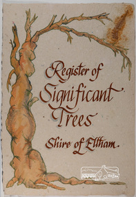
Work on paper - Folio, Register of Significant Trees, Shire of Eltham, c.1993
... Avenue of Honour to Eltham's First World War soldiers along Main Road between Dalton and Pitt Streets, Eltham. 5. Pinus canariensis (Canary Island Pine), Pinus pinea, (Stone pine) and Cedras altlantica, (Cedar) These trees are located at the Hurst family graves in the grounds of the Hurstbridge Pre-school Centre. In 1991 the Shire...Avenue of Honour to Eltham's First World War soldiers along Main Road between Dalton and Pitt Streets, Eltham. 5. Pinus canariensis (Canary Island Pine), Pinus pinea, (Stone pine) and Cedras altlantica, (Cedar) These trees are located at the Hurst family graves in the grounds of the Hurstbridge Pre-school Centre. In 1991 the Shire ...In 1983, the National Trust advised the Shire of Eltham that it was investigating a number of trees within the shire which had been nominated for recording the Register of Significant Trees of Victoria. The trees involved were described in the Shire of Eltham Historical Society Newsletter No. 29, March 1983 as follows:- 1. Eucalyptus melliadora (Yellow box) . a) An outstanding mature specimen 42 metres high in Laughing Waters Road, Eltham. b) Another mature specimen in Arthurs Creek road, Hurstbridge is reported to be the tree under which the bushranger Robert Bourke was tied after he shot and killed Henry Hurst in 1866 . 2. Quercus robur (English Oak). a) "Donaldson's Oak", Donaldsons Road, Kangaroo Ground was planted by John Donaldson from seed collected from Windsor Great Park in 1878. b) "Wippells Oak". This now misshapen tree is located on the St. Andrews Road near the Kangaroo Ground Fire Station. Its origins may have been similar to Donaldson's Oak, and as a young tree it apparently slipped from higher up the hill during wet weather. Both oaks are of local historical importance. 3. Eucalyptus globulus (Blue Gum). A large mature specimen at the corner of the Kangaroo Ground-St. Andrews Road and Bakehouse Road, Panton Hill. 4. Plantanas acerifolia (Plane tree) A number of trees forming the Avenue of Honour to Eltham's First World War soldiers along Main Road between Dalton and Pitt Streets, Eltham. 5. Pinus canariensis (Canary Island Pine), Pinus pinea, (Stone pine) and Cedras altlantica, (Cedar) These trees are located at the Hurst family graves in the grounds of the Hurstbridge Pre-school Centre. In 1991 the Shire of Eltham introduced controls into its planning scheme to protect sites of architectural, historic or conservation interest and significant trees. The controls were approved by the Minister for Planning and Housing. As advised in the Shire of Eltham Historical Society Newsletter No. 78, May 1991, a planning permit is required to demolish or alter any listed building or to destroy, lop or remove any listed tree. Provision is made for comments to be obtained from the National Trust or Historic Buildings Council in considering any applications. The buildings and trees listed were: Buildings: 250 Bolton Street Eltham (former Walter Withers home) "Rosehill" - Bonds Road Lower Plenty St Andrews Church of England - St Andrews "Montsalvat" - Hillcrest Avenue Eltham St Margarets Church and former vicarage - Pitt Street Eltham Presbyterian Church - Kangaroo Ground Parks and Environment Office (former police quarters) Main Road Eltham Former Court House - Main Road Eltham "Shillinglaw Cottage" - Main Road Eltham "The Robins" - Kangaroo Ground Road Warrandyte Trees: "Donaldsons Oak" - Donaldsons Road Kangaroo Ground Yellow Box - Laughing Waters Road Eltham Yellow Box - Arthurs Creek Road Hurstbridge Wippells Oak - St Andrews Road Kanqaroo Road Pines and Cedar - Hurst family cemetery Greysharps Road Hurstbridge Yellow Box - Parsons Road Eltham A large Blue Gum at Panton Hill has been listed but has recently died (1991). In 1993 work by Council Parks and Environment staff and volunteers resulted in the preparation of a Significant Tree Register listing forty-one trees or groups of trees. According to Shire of Eltham Historical Society Newsletter No. 91, March 1993, a similar number remained to be assessed for inclusion in the register. There is a wide range of indigenous and planted trees on private and public land and extending through the Shire of Eltham from Lower Plenty to Kinglake. Most can be viewed from publicly accessible locations. The Significant Tree Register lists 41 trees or groups of trees throughout the Shire. It contains a wide range of naturally occurring and planted trees. They have been assessed according to eleven criteria including size, age, rarity, historical value and the like. The list includes large old Red Gums at Lower Plenty, historic Oaks at Kangaroo Ground and Mountain Ash at Kinglake. The register includes a set of slides showing each tree. Garry Bartlett of the Council's Parks and Environment Section and Faye Shepherd were extensively involved in establishment of the register (Newsletter No. 93, November 1993). In 1999 Niliumbik planners prepared an amendment to the Planning Scheme to provide protection for approximately 200 of the places listed in the heritage studies and also in the Significant Tree Register commenced by the Eltham Council (Eltham District Historical Society Newsletter No. 127, July 1999. In 2004, The Register of Significant Trees was presented to the Eltham District Historical Society by Nillumbik Shire Council as part of a wider collection of of its memorabilia of the former Eltham Shire Council (EDHS Newsletter No. 159, July 2004. Album of loose handmade paper sheets contained within a handmade slip cover constructed of handcrafted card with encapsulated flora material (flowers, vines, ferns) and tinted. Each page also contains an embedded/adhered fern leaf also tinted with lacqueur or similar, text as appropriate in ink by hand calligraphy. Each page also has a white protective sheet cut to size and adhered to back surface with sticky tape and folded over face of page. Pages variously have photographs and coloured masks adhered with a gum resin. Over time much of this resin has let go and photos/masks have been reattached using acid free archival safe adhesive. 15 pages 41 x 29 cm inclusive of 3 blank pages. Slip case 42 x 30 x 1 cm; face cover of slip case has broken off at left hand margin as insufficient depth/flexibility for contents.arthurs creek road, blue gum (eucalyptus globulus), canary island pine (pinus canariensis), couties road, donaldsons oak, donaldsons road, eltham, english oak (quercus robur), eucalyptus melliodora, graysharps road, hurst tree, hurstbridge, ironbark (eucalyptus tricarpa), ironbark hill, kangaroo ground, kangaroo ground-kinglake road, laughing waters road, panton hill hotel, panton hill, parsons road, significant trees register, sonia van bodegraven, sonjart, stone pine (pinus pinea). atlantic cedar (cedrus atlantica), wippells oak, yellow box gum (eucalyptus melliodora), yellow box gum -
 Eltham District Historical Society Inc
Photograph, Fay Bridge, Rosehill Homestead, EDHS Heritage Excursion, 6 July 2019
... This area was the site of the first recorded European settlement in what was to become the Shire of Eltham when the Willis brothers arrived in the late 1830s. From the southern part of Cleveland Avenue there are extensive views across and along the Yarra Valley. ...This area was the site of the first recorded European settlement in what was to become the Shire of Eltham when the Willis brothers arrived in the late 1830s. From the southern part of Cleveland Avenue there are extensive views across and along the Yarra Valley. ...July Excursion July 6, 2019 - Exploring Lower Plenty The predominant feature of this walk in the Bonds Road area, Lower Plenty is the large number of magnificent old River Red Gums that line the route. These trees are of the spreading woodland form of this species indicating that they must have been originally growing in a reasonably open setting. The walk also includes parts of the historic Cleveland Estate and the homestead “Rosehill” established by pioneer farmer Henry Stooke. This area was the site of the first recorded European settlement in what was to become the Shire of Eltham when the Willis brothers arrived in the late 1830s. From the southern part of Cleveland Avenue there are extensive views across and along the Yarra Valley. An article on the history of this area was contained in Newsletter edition 201, November 2011. The walk will start at the at the corner of Bonds and Stawell Roads, Lower Plenty - EDHS Newsletter No. 246 June 2019fay bridge collection, 2019-07-06, blackburn bricks, eltham district historical society, heritage excursion, rosehill homestead, lower plenty -
 Eltham District Historical Society Inc
Document - Folder, Yarra Glen, 2006
... 2 pages Removed from HG Booklet 21 Transcript of "Opening of new road to Yarra Flats" Argus, 1 April 1875 Extracts of 3 letters from Shire of Eltham Correspondence Book No. 6 related to Welcome Home Committe and Avenue of Honour at Yarra Glen...Eltham District Historical Society Inc 728 Main Rd Eltham melbourne Eltham Shire Council Harry Gilham Collection Yarra Flats Yarra Glen Welcome Home Committee Batt's Hotel Brock charles wingrove Christmas Hills Eltham-Yarra Glen Road Kilpatrick memorial Monument Progress League Victoria Hall 2 pages Removed from HG Booklet 21 Transcript of "Opening of new road to Yarra Flats" Argus, 1 April 1875 Extracts of 3 letters from Shire of Eltham Correspondence Book No. 6 related to Welcome Home Committe and Avenue of Honour at Yarra Glen Yarra Glen Document Folder ...eltham shire council, harry gilham collection, yarra flats, yarra glen, welcome home committee, batt's hotel, brock, charles wingrove, christmas hills, eltham-yarra glen road, kilpatrick, memorial, monument, progress league, victoria hall -
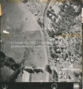
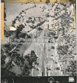
 Eltham District Historical Society Inc
Photograph - Aerial Photograph, Main Road Hurstbridge, corner of Rose Ave, 12 Apr. 1954
... shire of eltham archives...Aerial Photo...Main Road...Anzac Avenue...Eltham District Historical Society Inc 728 Main Rd Eltham melbourne Victorian Railways Aerial Survey shire of eltham archives Aerial Photo Main Road Anzac Avenue Hursbridge Parker Road Hurstbridge Railway Station Rose Road Black and white proto print; Size: 230x240 mm Condition: fair, sticky tape Main Road Hurstbridge, corner of Rose Ave Photograph Aerial Photograph ...Victorian Railways Aerial Surveyshire of eltham archives, aerial photo, main road, anzac avenue, hursbridge, parker road, hurstbridge railway station, rose road -
 Eltham District Historical Society Inc
Photograph - Aerial Photograph, Main Road, Hurstbridge; Rose Road to Anzac Avenue including Railway Station area, 12 Apr. 1954
... shire of eltham archives...Aerial Photo...Main Road...Anzac Avenue...Eltham District Historical Society Inc 728 Main Rd Eltham melbourne Victorian Railways Aerial Survey shire of eltham archives Aerial Photo Main Road Anzac Avenue Hursbridge Parker Road Hurstbridge Railway Station Rose Road Digital panorama created from items 4-9 Main Road, Hurstbridge; Rose Road to Anzac Avenue including Railway Station area Photograph Aerial Photograph ...Victorian Railways Aerial Surveyshire of eltham archives, aerial photo, main road, anzac avenue, hursbridge, parker road, hurstbridge railway station, rose road -
 Eltham District Historical Society Inc
Photograph - Aerial Photograph, Main Road Hurstbridge, Rose Ave to Parker Road, 12 Apr. 1954
... shire of eltham archives...Aerial Photo...Main Road...Anzac Avenue...Eltham District Historical Society Inc 728 Main Rd Eltham melbourne Victorian Railways Aerial Survey shire of eltham archives Aerial Photo Main Road Anzac Avenue Hursbridge Parker Road Hurstbridge Railway Station Rose Road Black and white proto print; Size: 230x240 mm Condition: fair, sticky tape Main Road Hurstbridge, Rose Ave to Parker Road Photograph Aerial Photograph ...Victorian Railways Aerial Surveyshire of eltham archives, aerial photo, main road, anzac avenue, hursbridge, parker road, hurstbridge railway station, rose road -
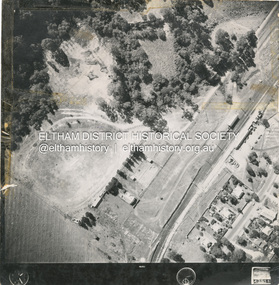 Eltham District Historical Society Inc
Photograph - Aerial Photograph, Main Road and Railway Station area, Hurstbridge, 12 Apr. 1954
... shire of eltham archives...Aerial Photo...Main Road...Anzac Avenue...Eltham District Historical Society Inc 728 Main Rd Eltham melbourne Victorian Railways Aerial Survey shire of eltham archives Aerial Photo Main Road Anzac Avenue Hursbridge Parker Road Hurstbridge Railway Station Rose Road Black and white proto print; Size: 230x240 mm Condition: fair, sticky tape Main Road and Railway Station area, Hurstbridge Photograph Aerial Photograph ...Victorian Railways Aerial Surveyshire of eltham archives, aerial photo, main road, anzac avenue, hursbridge, parker road, hurstbridge railway station, rose road -
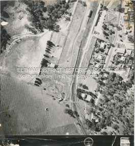
 Eltham District Historical Society Inc
Photograph - Aerial Photograph, Main Road and Anzac Ave intersection, Hurstbridge, 12 Apr. 1954
... shire of eltham archives...Aerial Photo...Main Road...Anzac Avenue...Eltham District Historical Society Inc 728 Main Rd Eltham melbourne Victorian Railways Aerial Survey shire of eltham archives Aerial Photo Main Road Anzac Avenue Hursbridge Parker Road Hurstbridge Railway Station Rose Road Stamped VR Aerial Survey This print is not rectified Scale Approx 160' to 1 inch Date Photographed 12.4.54 Written Series 33, Item 9 Black and white proto print; Size: 230x240 mm Condition: fair, sticky tape Main Road and Anzac Ave intersection, Hurstbridge Photograph Aerial Photograph ...Victorian Railways Aerial SurveyStamped VR Aerial Survey This print is not rectified Scale Approx 160' to 1 inch Date Photographed 12.4.54 Written Series 33, Item 9shire of eltham archives, aerial photo, main road, anzac avenue, hursbridge, parker road, hurstbridge railway station, rose road -
 Eltham District Historical Society Inc
Album - Document, J.A. McDonald, Report to Works Committee: Garbage Disposal, Eltham and Montmorency Ridings, c. 1956
... shire of eltham...Benchmark studies...Box Hill State School...Box Hill Teachers College...Box Hill Tip...Andrew Park...Camberwell City Council Tip...Eltham Lower Park...Eltham Tip...Health Inspector...Heidelberg City Tip...J.A. McDonald...Montmorency Park...Panorama Avenue...Infrastructure shire of eltham Benchmark studies Box Hill State School Box Hill Teachers College Box Hill Tip Andrew Park Camberwell City Council Tip Eltham Lower Park Eltham Tip Health Inspector Heidelberg City Tip J.A. McDonald Montmorency Park Panorama Avenue ...Reference report associated with photos: EDHS_05569-30-4 Box Hill Tip EDHS_05569-30-6 Camberwell Tip EDHS_05569-30-7 Camberwell Tip EDHS_05569-30-8 Camberwell TipRecord of various Shire of Eltham infrastructure works undertaken during the period of 1952-1962 involving bridge and road reconstruction projects, sometimes with Eltham Shire Council Project Reference numbers quoted. It was during this period that a number of significant improvements were made to roads and new bridges constructed within the shire that remain in place as of present day (2022). In many situations, the photos provide a tangible visible record of infrastructure that existed throughout the early days of the Shire. The album was put together by or under the direction of the Shire Engineer, J.A. McDonald.infrastructure, shire of eltham, benchmark studies, box hill state school, box hill teachers college, box hill tip, andrew park, camberwell city council tip, eltham lower park, eltham tip, health inspector, heidelberg city tip, j.a. mcdonald, montmorency park, panorama avenue, report, road construction, shire engineer, skyline theatre, tips, w.u. hughes, works committee: garbage disposal -
 Eltham District Historical Society Inc
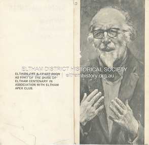
Folder, Jorgensen, Justus
... MacMahon Ball, Montsalvat, Hillcrtest Avenue, Eltham , Saturday 3rd April (1971) at 11.00 a.m.. (Eltham Art and Craft show as part of the Shire of Eltham Centenary in association with Eltham Apex Club). 2. ...MacMahon Ball, Montsalvat, Hillcrtest Avenue, Eltham , Saturday 3rd April (1971) at 11.00 a.m.. (Eltham Art and Craft show as part of the Shire of Eltham Centenary in association with Eltham Apex Club). 2. ...1. Exhibition Invitation: Justus Jorgensen; Paintings, Drawings, Sculpture, A Retrosepctive Exhibition, to be opened by Professor W. MacMahon Ball, Montsalvat, Hillcrtest Avenue, Eltham , Saturday 3rd April (1971) at 11.00 a.m.. (Eltham Art and Craft show as part of the Shire of Eltham Centenary in association with Eltham Apex Club). 2. Mini Biography: Justus Jorgensen (1894-1975) 3. An ode to the trendies, John March, The Age, Saturday, August 12, 1978, p15 - a review of a visit to Montsalvat and poetry reading during the 1978 Eltham Fesitval. Includes picture of Justus Jorgensen and cartoon sketch by Harper (?) 4. Mini Biography: Justus JorgensenFolder of information on Justus Jorgensen, artist and architect, Montsalvat.justus jorgensen, artist, eltham apex club, eltham art & craft show, exhibition, invitation, montsalvat, shire of eltham centenary, william macmahon ball, biography, 1978, david campbell, dorothy hewett, eltham festival, frank kellaway, poetry reading, poets, rosemary dobson, eltham cemetery, lily jorgensen -
Glen Eira Historical Society
Document - Historic Conservation Areas Project
... Shire of Caulfield... Railways... World War 1914-1918... Depression 1929-1939... Rippon Lea... Labassa... Parks... Mansions... Community Services... ‘Caulfield North Draft Heritage Guidelines July 1999’... City of Glen Eira... Caulfield North Heritage Area... Glen Eira Heritage Management Plan... Mayfield Grove... Normanby Avenue...Caulfield Library Dandenong Road Nepean Highway Hotham Street Iknerman Road Orrong Road North Road Poath Road ‘Plan of the City of Caulfield’ North Ward East Ward South Ward West Ward Kooyong Road Neerim Road Bambra Road Balaclava Road Shire of Caulfield Railways World War 1914-1918 Depression 1929-1939 Rippon Lea Labassa Parks Mansions Community Services ‘Caulfield North Draft Heritage Guidelines July 1999’ City of Glen Eira Caulfield North Heritage Area Glen Eira Heritage Management Plan Mayfield Grove Normanby Avenue Carnarvon Street Glenferrie Street Arthur Street Malakoff Street Normanby Road Heritage Advisory Service Construction Materials Victorian Style Mediterranean Style Spanish Mission Style Californian Bungalow Style Federation Style Architectural Style Architectural Features Heritage Conservation Design Building Construction Building Regulations Aboriginal Peoples Carnarvon Road Document Historic Conservation Areas Project ...Contains 4 items relating to historic conservation: 1/Five newsletters (one page each newsletter, dated 07/1975, 08/1975, 09/1975, 10/1975 and the final one 12/1975) describing how the project evolved, project funds, progress, study method, project 1 report, project 2 report and summary as no further funds available. Project was to include all of Melbourne but funding did not allow this. Note: newsletters stamped with Caulfield Historical Society. 2/Letter (one page on official city of Caulfield letterhead) from Andrew Rodda (manager planning) to Hazal Ford (dated 13/11/1989) describing ‘council resolved on 18/07/1989 to proceed with preliminary conservation survey’ and mentions that a copy is included. 3/Preliminary conservation survey for the City of Caulfield (nine pages) describing background, study area, budget, purpose, study outline, timeframe, report format, ownership, tasks and background information (mentions number and types of houses and properties as at 1986 and 1988) and a map of City of Caulfield. 4/Booklet (28 pages) titled ‘Heritage Area – Caulfield North Draft Heritage Guidelines July 1999 – City of Glen Eira’, containing Caulfield North Heritage Area, cultural heritage, Heritage Overlay Area, architectural description, common architectural forms and features, development guidelines, key design checklist. It includes a map of the Caulfield North Heritage Overlay Area, two illustrations about the development envelope and many black-and-white photographs of houses and architectural features.historic conservation areas project niven barbara, newsletters, town planning, historic buildings, heritage studies, housing, royal historical society of victoria (rhsv), read michael, plans, local government, historical societies, committee for urban action (cua), national trust, hopkins sherry ms., ford hazel, preliminary conservation survey, town planning, heritage studies, rodda andrew, city of caulfield, housing estates, victoria national estate grants program, australia icomos, burra charter, buildings structures and establishments, land surveys, suburbs, historic buildings, architectural significance, ‘caulfield’s heritage study’, soloman geulah dr., caulfield library, dandenong road, nepean highway, hotham street, iknerman road, orrong road, north road, poath road, ‘plan of the city of caulfield’, north ward, east ward, south ward, west ward, kooyong road, neerim road, bambra road, balaclava road, shire of caulfield, railways, world war 1914-1918, depression 1929-1939, rippon lea, labassa, parks, mansions, community services, ‘caulfield north draft heritage guidelines july 1999’, city of glen eira, caulfield north heritage area, glen eira heritage management plan, mayfield grove, normanby avenue, carnarvon street, glenferrie street, arthur street, malakoff street, normanby road, heritage advisory service, construction materials, victorian style, mediterranean style, spanish mission style, californian bungalow style, federation style, architectural style, architectural features, heritage conservation design, building construction, building regulations, aboriginal peoples, carnarvon road -
Glen Eira Historical Society
Document - KOOYONG ROAD, 75, CAULFIELD NORTH
... Avenue... Kooyong Road... Caulfield Racecourse... Caulfield Town Hall... Alma Road... Red Cheques Cab Company... Army Headquarters Printing Press... Searchlight Company... Amenities Store... Armoured Replacement Unit... First Base Printing Company R.A.A.O.C.... Garden Vale... Caulfield Railway Station... Paddy’s Swamp... Great Dandenong Road... Glen Ferrie Road... Dandenong Road... East Caulfield Reserve... Caulfield Military Hospital... ‘Glen Eira’... Town Hall... ‘War Office’... Caulfield District Road Board... Shire...(Chief Superintendent) City Hall Balaclava Road Hawthorn Road Glen Eira Road Hartley Avenue Kooyong Road Caulfield Racecourse Caulfield Town Hall Alma Road Red Cheques Cab Company Army Headquarters Printing Press Searchlight Company Amenities Store Armoured Replacement Unit First Base Printing Company R.A.A.O.C. Garden Vale Caulfield Railway Station Paddy’s Swamp Great Dandenong Road Glen Ferrie Road Dandenong Road East Caulfield Reserve Caulfield Military Hospital ‘Glen Eira’ Town Hall ‘War Office’ Caulfield District Road Board Shire of Caulfield Caulfield Recruiting Committee for Volunteers City Repatriation Committee Red Cross Emergency Service Women’s National Service Mayor’s Patriotic Fund Promotions Committee for War Savings Certificates War Savings Group Scheme ‘The Gazette’ Air Raid Precautions Committee Orrong Road Armed Forces World War 1939-1945 Local Government Parades and Processions Military Reserves World War 1914-1918 Councillors Events and Activities Historic Events Official Events Caulfield John Wyne Agar Murphy (Mayor) Hale P. ...Two copies of a pamphlet for the ceremony of the Third Ordnance Services Unit ‘Exercising the Right of the Freedom of Entry to the City of Caulfield’ held on 23/10/1983. The pamphlet includes a brief history of the unit’s association with the City of Caulfield, a list of individuals holding posts within the Unit, text of the scroll conferring the Freedom of Entry on the Unit, a program of the ceremony, a brief history of the Royal Australian Army Ordnance Corps including the Unit’s use of 75 Kooyong Road as their premises, a brief history of the City of Caulfield from 1937-postwar years, and an explanation of the tradition of conferring Freedom of Entry to a city. The pamphlet includes also: 1/A black and white photograph (47x35mm) of the Mayor of Caulfield, W.R. Walters, undated and unattributed. 2/A black and white photograph (81x69mm) of Major A.G. Storen, Commanding Officer of the Third Ordnance Services Unit, undated and unattributed. 3/A color photograph (88x84mm) of the Sovereign’s Banner, undated and unattributed. 4/A black and white copy (137x87mm) of the scroll conferring Freedom of Entry into the City of Caulfield, which was seated August 4 1978. 5/A color illustration (30x32mm) of the City of Caulfield Coat of Arms. 6/A color illustration (40x32mm) of the Third Ordnance Services Unit, Royal Australian Army Ordnance Corps Coat of Arms. 7/A black and white illustration (21x24mm) of the city of Caulfield Coat of Arms. 8/A black and white illustration (19x14mm) of the City of Caulfield badge. 9/A black and white illustration (22x31mm) of the City of Caulfield banner.walters w.r., storen a.g. major, finning d.j. captain, hately p.g. major, davidson j. (captain), swendson r. (second lieutenant), caulfield, city of caulfield, australian army, the third ordnance services unit royal australian army ordnance corps, caulfield park, caulfield council, north caulfield, campton e.j. (brigadier), walters w.r. mrs., calder g.k., calder g.k. mrs., mahon j. (chief superintendent), city hall, balaclava road, hawthorn road, glen eira road, hartley avenue, kooyong road, caulfield racecourse, caulfield town hall, alma road, red cheques cab company, army headquarters printing press, searchlight company, amenities store, armoured replacement unit, first base printing company r.a.a.o.c., garden vale, caulfield railway station, paddy’s swamp, great dandenong road, glen ferrie road, dandenong road, east caulfield reserve, caulfield military hospital, ‘glen eira’, town hall, ‘war office’, caulfield district road board, shire of caulfield, caulfield recruiting committee for volunteers, city repatriation committee, red cross emergency service, women’s national service, mayor’s patriotic fund, promotions committee for war savings certificates, war savings group scheme, ‘the gazette’, air raid precautions committee, orrong road, armed forces, world war 1939-1945, local government, parades and processions, military reserves, world war 1914-1918, councillors, events and activities, historic events, official events, caulfield john, wyne agar, murphy (mayor), hale p., ison (captain), fisher andrew, morris t.w. (mayor) -
Glen Eira Historical Society
Document - KOOYONG ROAD, 75, CAULFIELD NORTH
... Avenue... Caulfield Racecourse... Caulfield Town Hall... Alma Road... Orrong Road... Garden Vale... Caulfield Railway Station... Paddy’s Swamp... Great Dandenong Road... Glen Ferrie Road... Dandenong Road... East Caulfield Reserve... Caulfield Military Hospital... ‘Glen Eira’... Town Hall... ‘War Office’... Red Chequer Cab Company... Caulfield Council... Third Ordnance Services Unit Royal Australian Army Ordnance Corps... Australian Army... Army Headquarters Printing Press... Searchlight Company... Amenities Store... Armoured Replacement Unit... First Base Printing Company R.A.A.O.C.... Caulfield District Road Board... Shire...(Mayor) Caulfield Kooyong Road Caulfield Park North Caulfield City of Caulfield City Hall Balaclava Road Hawthorn Road Glen Eira Road Hartley Avenue Caulfield Racecourse Caulfield Town Hall Alma Road Orrong Road Garden Vale Caulfield Railway Station Paddy’s Swamp Great Dandenong Road Glen Ferrie Road Dandenong Road East Caulfield Reserve Caulfield Military Hospital ‘Glen Eira’ Town Hall ‘War Office’ Red Chequer Cab Company Caulfield Council Third Ordnance Services Unit Royal Australian Army Ordnance Corps Australian Army Army Headquarters Printing Press Searchlight Company Amenities Store Armoured Replacement Unit First Base Printing Company R.A.A.O.C. Caulfield District Road Board Shire ...Three copies of a pamphlet for the ceremony of the Third Ordnance Services Unit ‘Exercising the Right of the Freedom of Entry to the City of Caulfield’, held on 13/07/1986. The pamphlet includes a brief history of the Unit’s association with the City of Caulfield, a list of individuals holding posts within the unit, text of the scroll conferring the Freedom of Entry on the Unit, a program of the ceremony, a brief history of the Royal Australian Army Ordnance Corps, including the Unit’s use of 75 Kooyong Road as their premises, a brief history of the city of Caulfield and an explanation of the tradition of conferring Freedom of Entry to a city. The pamphlet includes also: 1/A black and white photograph (61x66mm) of the Mayor of Caulfield, Maxwell Blair, undated and unattributed. 2/A black and white photograph (70x51mm) of Major P.G. Hateley, Commanding Officer of the Third Ordnance Services Unit, undated and unattributed. 3/A black and white photograph (91x90mm) of the Sovereign’s Banner, undated and unattributed. 4/A black and white copy (137-87) of the scroll conferring Freedom of Entry into the City of Caulfield which was seated August 4 1978. 5/A color illustration (30x32mm) of the City of Caulfield Coat of Arms. 6/A colour illustration (40x32mm) of the Third Ordnance Services Unit, Royal Australian Army Ordnance Corps Coat of Arms. 7/A black and white illustration (21x24mm) of the City of Caulfield Coat of Arms. 8/A black and white illustration (19x19mm) of the City of Caulfield badge. 9/A black and white illustration (22x31mm) of the City of Caulfield banner.blair maxwell (mayor), hateley p.g. (major), finning d.j. (captain), lowe g. (captain), barker l.a. (lieutenant), blair mrs., aylen d.r., aylan d.r. mrs., goltz m.h., compton e.j. (brigadier), goltz m.h. (chief superintendant), caulfield john, wynne agar, murphy (mayor), hate p., ison (captain), fisher andrew, morris t.w. (mayor), caulfield, kooyong road, caulfield park, north caulfield, city of caulfield, city hall, balaclava road, hawthorn road, glen eira road, hartley avenue, caulfield racecourse, caulfield town hall, alma road, orrong road, garden vale, caulfield railway station, paddy’s swamp, great dandenong road, glen ferrie road, dandenong road, east caulfield reserve, caulfield military hospital, ‘glen eira’, town hall, ‘war office’, red chequer cab company, caulfield council, third ordnance services unit royal australian army ordnance corps, australian army, army headquarters printing press, searchlight company, amenities store, armoured replacement unit, first base printing company r.a.a.o.c., caulfield district road board, shire of caulfield, caulfield recruiting committee for volunteers, city repatriation committee, red cross emergency service, women’s national service, mayor’s patriotic fund, promotions committee for war savings certificates, war savings group scheme, ‘the gazette’, air raid precautions committee, armed forces, world war 1939-1945, local government, parades and processions, military reserves, world war 1914-1918, councillors, events and activities, historic events, official events -
Glen Eira Historical Society
Letter - ‘MOOD KEE’
... Avenue... Caulfield Town Hall... ‘Rosecraddock’... Caulfield... Davies Sydney... Langdon family... ‘Mood Kee’... fonts... ‘Yerangle’... House names... St Mary’s Church of England... Johnstone Brid. Gen.... Subdivisions... Swagmen... Johnstone Mrs... Davis Sydney... R.S.L Club... ‘Ripley’... Slaney family... ‘Sylverly’... ‘Belton’... Davis Family... Glen Eira... ‘Garrell’... Greenwood Family... ‘Sanquar’... Kooyong Road... Bell Family... ‘Royston’... Slatter Family... ‘Hengar’... Glen Eira Road... Langdon Family... Joynes Gwen... Davis Gwen... Mosley G Mrs... Davies Mrs... Mudge Mrs... Slate tiles... Verandahs... Weatherboard buildings... Brick houses... Bluestone... Board and Shire...Avenue Caulfield Town Hall ‘Rosecraddock’ Caulfield Davies Sydney Langdon family ‘Mood Kee’ fonts ‘Yerangle’ House names St Mary’s Church of England Johnstone Brid. Gen. Subdivisions Swagmen Johnstone Mrs Davis Sydney R.S.L Club ‘Ripley’ Slaney family ‘Sylverly’ ‘Belton’ Davis Family Glen Eira ‘Garrell’ Greenwood Family ‘Sanquar’ Kooyong Road Bell Family ‘Royston’ Slatter Family ‘Hengar’ Glen Eira Road Langdon Family Joynes Gwen Davis Gwen Mosley G Mrs Davies Mrs Mudge Mrs Slate tiles Verandahs Weatherboard buildings Brick houses Bluestone Board and Shire Offices Letter ‘MOOD KEE’ ...Three items about this property, two of which were provided by Peter R Murray (author of ‘From sand, swamp and heath...’. 1/A handwritten letter to P Murray from ex resident Gwen Joynes giving some history on people and places, possibly to help with his book on Caulfield’s past. Dated 08/12/1976. 2/A handwritten letter to Mr Murray from Gwen Joynes with details about accompanying photograph of ‘Moodkee’ and people in photograph; photograph presumably returned as requested. Dated 24/03/1977 3/A photocopied photo of Mood Kee and some written research from Sand Swamp and Heath. Photo likely to be that referred to above.pennington harold, caulfield council’s meeting room, harcourt avenue, caulfield town hall, ‘rosecraddock’, caulfield, davies sydney, langdon family, ‘mood kee’, fonts, ‘yerangle’, house names, st mary’s church of england, johnstone brid. gen., subdivisions, swagmen, johnstone mrs, davis sydney, r.s.l club, ‘ripley’, slaney family, ‘sylverly’, ‘belton’, davis family, glen eira, ‘garrell’, greenwood family, ‘sanquar’, kooyong road, bell family, ‘royston’, slatter family, ‘hengar’, glen eira road, langdon family, joynes gwen, davis gwen, mosley g mrs, davies mrs, mudge mrs, slate tiles, verandahs, weatherboard buildings, brick houses, bluestone, board and shire offices