
Showing 739 items matching "shopping area"
-
 Canterbury History Group
Document - Maling Road shopping area and traffic strategy plan, ARUP Transportation Planning, February 1994
... Maling Road shopping area and traffic strategy plan......Shopping area...Draft of Strategy Planning for shopping and traffic in Maling Road Maling Road Strategy Plan Parking and traffic Shopping area Maling Road Shopping Area Steering Committee 17 pages in black and white type, A4 size and 1 A3 sheet included 9 maps and 1 char tin black and white Document Maling Road shopping area and traffic strategy plan ARUP Transportation Planning ...Draft of Strategy Planning for shopping and traffic in Maling Road17 pages in black and white type, A4 size and 1 A3 sheet included 9 maps and 1 char tin black and whitemaling road, strategy plan, parking and traffic, shopping area, maling road shopping area steering committee -
 Chelsea & District Historical Society Inc
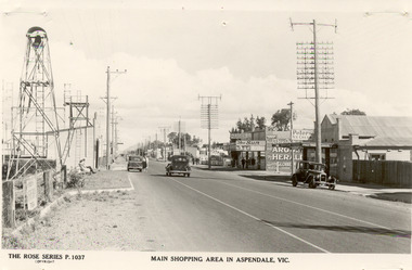
Photograph - Shopping Area, Aspendale, c 1930's
... Shopping Area, Aspendale...The Rose Series P. 1037 MAIN SHOPPING AREA IN ASPENDALE, VIC....The shops in view are a cafe, a general store, the Aspendale Picnic Grounds, which included Palais De Dance. Photograph Shopping Area, Aspendale ...Black and white postcard showing shops on the right hand side of Point Nepean Road and the railway line, Aspendale railway station and the Aspendale Fire Station with the bell tower beside it. One car driving along the road and two cars parked. The shops in view are a cafe, a general store, the Aspendale Picnic Grounds, which included Palais De Dance.The Rose Series P. 1037 MAIN SHOPPING AREA IN ASPENDALE, VIC.point nepean road, nepean highway, aspendale, taylor avenue, shops, aspendale fire station, aspendale picnic grounds -
 Bendigo Historical Society Inc.
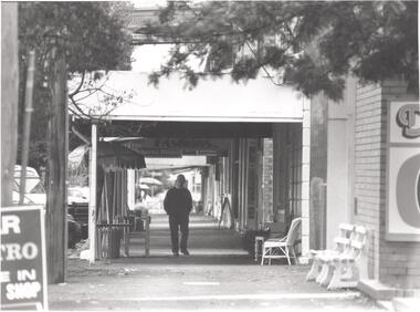
Photograph - PHOTOGRAPH. ELMORE. SHOPPING AREA, 1993
... PHOTOGRAPH. ELMORE. SHOPPING AREA....Person walking towards camera on shopping area footpath. Note chairs at front of business for use of the public....Photograph PHOTOGRAPH. ELMORE. SHOPPING AREA. ...Photograph. Elmore. Person walking towards camera on shopping area footpath. Note chairs at front of business for use of the public. -
 Ringwood and District Historical Society
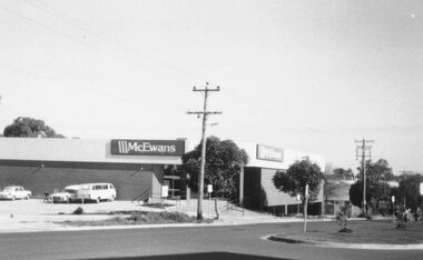
Photograph, McEwans Ringwood New shopping area 1984
... McEwans Ringwood New shopping area 1984...Written on back of photograph, "McEwans 1984. New shopping area."...Written on back of photograph, "McEwans 1984. New shopping area." McEwans Ringwood New shopping area 1984 Photograph ...Written on back of photograph, "McEwans 1984. New shopping area." -
 Stawell Historical Society Inc
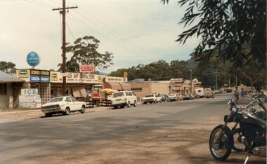
Photograph, Shopping Area at Halls Gap 1985
... Shopping Area at Halls Gap 1985...Shopping Area Halls Gap 1985...Shopping Area Halls Gap 1985 businesses Shopping Area at Halls Gap 1985 Photograph ...Shopping Area Halls Gap 1985businesses -
 Greensborough Historical Society
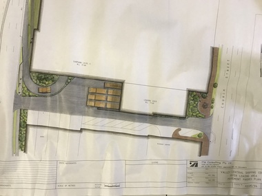
Plan, TTM Consulting, Valley Central Shopping Centre, Myer Loading Area, 1993_11
... Valley Central Shopping Centre, Myer Loading Area...Plan for the pavement finishes at the Myer loading area at Valley Central Shopping Centre (now Greensborough Plaza) between The Circuit and Church Street....Valley Central Shopping Centre, Myer Loading Area Plan TTM Consulting ...Plan for the pavement finishes at the Myer loading area at Valley Central Shopping Centre (now Greensborough Plaza) between The Circuit and Church Street.Plan of loading dock showing pavement finishes. Colour and black ink on white paper.greensborough plaza, the circuit greensborough, church street greensborough -
Whitehorse Historical Society Inc.
Document, Mitcham Shopping Centre Improvement Scheme, c. 1973
... Mitcham Shopping Area Development brief....Mitcham Shopping Centre Development Mitcham Shopping Area Development brief. Mitcham Shopping Area Development brief. ...Mitcham Shopping Area Development brief.Mitcham Shopping Area Development brief.Mitcham Shopping Area Development brief.mitcham shopping centre, development -
 Friends of Ballarat Botanical Gardens History Group
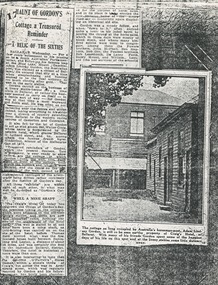
Work on paper - "Haunt of Gordon's" Newspaper Article pre 1934, Cottage a Treasured Reminder: A Relic of the Sixties", pre 1934
... Written in longhand, righthand corner is, Shopping area, Ballarat and underneath Courier....John Garner Doctor John Garner Collection Ballarat Botanical Gardens Friends of the Ballarat Botanical Gardens Ballarat Courier Adam Lindsay Gordon Cottage Craig's Hotel Bath Lane Australian "horseman poet" Livery Stables O'Farell's Horse Bazaar Gardens Ballarat Written in longhand, righthand corner is, Shopping area, Ballarat and underneath Courier. ...The page gives unique information about Adam Lindsay Gordon and a picture of the Gordon Cottage in its original state.The heading and by-lines in the Ballarat Courier attest to the significance of the extract and picture: "Haunt of Gordon's. Cottage a Treasured Reminder, A Relic of the Sixties".There are three sections to the newspaper article and one picture in the centre of the page. 2 sections are on the lefthand side of the page and one section above the picture; all roughly cut out. There is the number 17 recorded on the lefthand side of the main heading. Some lines have been roughly underlined.Written in longhand, righthand corner is, Shopping area, Ballarat and underneath Courier.john garner, doctor, john garner collection, ballarat botanical gardens, friends of the ballarat botanical gardens, ballarat courier, adam lindsay gordon cottage, craig's hotel, bath lane, australian "horseman poet", livery stables, o'farell's horse bazaar, gardens, ballarat -
 Whitehorse Historical Society Inc.
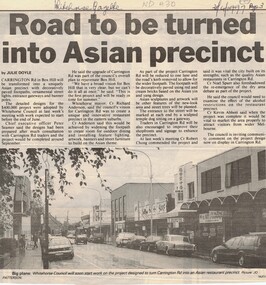
Article, Carrington Road Box Hill, 30/04/1998 12:00:00 AM
... Whitehorse Council's plans to improve Carrington Road Box Hill shopping area...carrington road box hill city of whitehorse Whitehorse Council's plans to improve Carrington Road Whitehorse Council's plans to improve Carrington Road Box Hill shopping area Carrington Road Box Hill Article Article ...Whitehorse Council's plans to improve Carrington RoadWhitehorse Council's plans to improve Carrington Road Box Hill shopping areaWhitehorse Council's plans to improve Carrington Roadcarrington road, box hill, city of whitehorse -
 Ringwood and District Historical Society
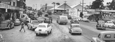
Photograph, Maroondah Highway West, Ringwood, 1955. Saturday morning shopping in Maroondah Highway
... Black and white photograph of shopping area along Maroondah Highway. Coolstores in background. (2 copies)...Black and white photograph of shopping area along Maroondah Highway. Coolstores in background. (2 copies) Maroondah Highway West, Ringwood, 1955. ...Black and white photograph of shopping area along Maroondah Highway. Coolstores in background. (2 copies)Typed below photograph: "Saturday morning shopping in Maroondah Highway looking towards corner of Wantirna Rd. with old coolstores in background. 1955. Written on back of loose photograph, "Wantirna Rd. between Ibbotson's and coolstore.coolstore -
 Greensborough Historical Society
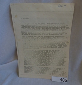
Document - Manuscript, Late Thoughts! by June Roberts, 1978
... A 3 page typed manuscript and a hand drawn plan of Greensborough shopping area based on the document....A 3 page typed manuscript and a hand drawn plan of Greensborough shopping area based on the document. Late Thoughts! ...This was prepared by June Roberts with assistance from Grace Cavill. Written in 1978 it includes details of Greensborough's Main Street from circa 1958-1978.Describes the locations of the Main Street traders in the 1950s. Also mentions the efforts needed to replace the Plenty River footbridge after it was washed away in a flood.A 3 page typed manuscript and a hand drawn plan of Greensborough shopping area based on the document.Sept 78 in blue biro on front page.main street shops, tom vickers, hume street, griffiths haberdashery, popes, flintoff street, plenty river bridge, stubleys hardware, stan ashleys menswear, hume street residences, rob willett, ashril theatre -
Whitehorse Historical Society Inc.
Document, Wandering dogs, 1937
... List of shopping areas specified by the Shire of Blackburn and Mitcham in which dogs are banned unless on a lead. ...List of shopping areas specified by the Shire of Blackburn and Mitcham in which dogs are banned unless on a lead. ...ist of shopping areas specified by the Shire of Blackburn and Mitcham in which dogs are banned unless on a lead.List of shopping areas specified by the Shire of Blackburn and Mitcham in which dogs are banned unless on a lead. Notice to be sent to papers.ist of shopping areas specified by the Shire of Blackburn and Mitcham in which dogs are banned unless on a lead. local government, shire of blackburn and mitcham, bishop, herbert thomas, dogs, shopping centres -
 Clunes Museum
Photograph
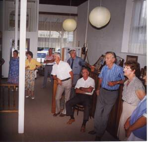
... ROBERT SEERS, RON PRYOR , CHARLES FENTON, MAVIS CARSON, IN CLUNES MUSEUM GROUND FLOOR - SHOP AREA...ROBERT SEERS, RON PRYOR , CHARLES FENTON, MAVIS CARSON, IN CLUNES MUSEUM GROUND FLOOR - SHOP AREA Photograph PHOTOGRAPH ...ENID STEART ? ROBERT SEERS, RON PRYOR , CHARLES FENTON, MAVIS CARSON, IN CLUNES MUSEUM GROUND FLOOR - SHOP AREAlocal history, photography, photographs, museum, clunes -
 Lakes Entrance Historical Society
Photograph - Trades, Lakes Post Newspaper, 1/09/1994 12:00:00 AM
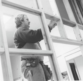
... Black and white photograph of Philip 'Pinky"" Baade builder at work extending the shop area at Lakes Post shopfront Lakes Entrance Victoria...Businesses Renovations Newspapers Trades Black and white photograph of Philip 'Pinky"" Baade builder at work extending the shop area at Lakes Post shopfront Lakes Entrance Victoria Photograph Trades Lakes Post Newspaper ...Black and white photograph of Philip 'Pinky"" Baade builder at work extending the shop area at Lakes Post shopfront Lakes Entrance Victoriabusinesses, renovations, newspapers, trades -
Dandenong & District Historical Society
Booklet - Wonders of Dandenong Walking Tour, 19 August 2026
... Some photos have name of building, names of people, short articles from Gippsland Gate, maps all of the Dandenong shopping area and near by outer areas....Some photos have name of building, names of people, short articles from Gippsland Gate, maps all of the Dandenong shopping area and near by outer areas. Display Book including photocopied pictures of streets, shops, hotels, halls and people Booklet Wonders of Dandenong Walking Tour ...Booklet used for display purposes and useful for walking tour.Display Book including photocopied pictures of streets, shops, hotels, halls and peoplenon-fictionBooklet used for display purposes and useful for walking tour.buildings, churches -
 Orbost & District Historical Society
coloured photographs, 1948 1954 ?
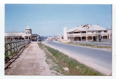
... Two coloured photographs. 3275.1 is a streetscape with a large hotel on the right, a main shopping area in the background and a wooden fence on the left. 3275,2 is overlooking backyards and fences. ...Orbost-1950s Orbost-House Commonwealth-Hotel on back - 1948-1954 Two coloured photographs. 3275.1 is a streetscape with a large hotel on the right, a main shopping area in the background and a wooden fence on the left. 3275,2 is overlooking backyards and fences. ...These photographs were probably taken in the late 1940s - mid 1950s. 3275.1 was taken at the roundabout in Nicholson Street / Salisbury Street intersection looking south. On the right is the The Commonwealth Hotel and the Gippsland Northern Store can be seen on the right. The war memorial can be seen in the centre of the intersection. 3275.2 has been taken from a height (possibly from behind the hardware store) overlooking Orbost House in McLeod Street. The butter factory can be seen in the background. Back yard toilets and paling fences can be seen with a narrow lane for the sanitary truck. Mrs Ruth Hannah Macalister, 1861-1932, established “Orbost House” as a boarding house in about 1900. Following her demise “Orbost House” was taken over by her son, “Reg” and his wife and they continued the Macalister family‟s association until the accommodation house was purchased by “Slim” and Eileen Somerville and Lindsay and Joan Jensen, in partnership, in 1963. (info. from Marilyn Morgan)These photographs are detailed pictorial records of Orbost in the mid 20th century. They show the objects in their spatial context with detail.Two coloured photographs. 3275.1 is a streetscape with a large hotel on the right, a main shopping area in the background and a wooden fence on the left. 3275,2 is overlooking backyards and fences. In the middle is an extensive red roof with "ORBOST HOUSE" in white print.on back - 1948-1954orbost-1950s orbost-house commonwealth-hotel -
 Kilmore Historical Society
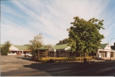
Photograph, 47-49 Sydney Street, 1995
... 15cm x 10 cm coloured photograph of the Kilmore Central Shopping Area which includes Commonwealth Bank and Post Office. ...Shopfronts Retail stores Storefronts 15cm x 10 cm coloured photograph of the Kilmore Central Shopping Area which includes Commonwealth Bank and Post Office. ...15cm x 10 cm coloured photograph of the Kilmore Central Shopping Area which includes Commonwealth Bank and Post Office. Single story building with green corrugated roofing with adjoining awnings and a central car park. shopfronts, retail stores, storefronts -
 Phillip Island and District Historical Society Inc.
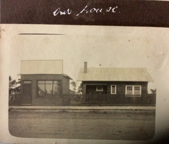
Photograph, Our house, 1925-1926
... Possibly in shopping area of Cowes....Possibly in shopping area of Cowes. photographs homes and haunts cowes shop buildings Our house Small sepia photograph of two buildings beside unmade road. ...Possibly in shopping area of Cowes.Small sepia photograph of two buildings beside unmade road. On left is a small shop, that looks empty. On right is a small timber house with a metal roof.Our housephotographs, homes and haunts, cowes shop buildings -
 Old Colonists' Association of Ballarat Inc.
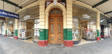
Photograph, Clare Gervasoni, Old Colonists' Hall, Ballarat, 2020, 09/05/2020
... Colour photograph of the entrance of a double storey building in Lydiard Street Notth known as the Ballarat Old Colonists' Hall It was taken during the Covid 19 Pandemic lockdown. when there was little activity in the shopping areas. Collins Booksellers are tenants of the shops associated with the Hall. ...The Old Colonists' Hall was opened in 1887. old colonists' association ballarat ballarat old colonists' club ballarat old colonists' hall shopfront lydiard street north Colour photograph of the entrance of a double storey building in Lydiard Street Notth known as the Ballarat Old Colonists' Hall It was taken during the Covid 19 Pandemic lockdown. when there was little activity in the shopping areas. Collins Booksellers are tenants of the shops associated with the Hall. ...The Old Colonists' Hall was opened in 1887. Colour photograph of the entrance of a double storey building in Lydiard Street Notth known as the Ballarat Old Colonists' Hall It was taken during the Covid 19 Pandemic lockdown. when there was little activity in the shopping areas. Collins Booksellers are tenants of the shops associated with the Hall. old colonists' association ballarat, ballarat old colonists' club, ballarat old colonists' hall, shopfront, lydiard street north -
 Whitehorse Historical Society Inc.
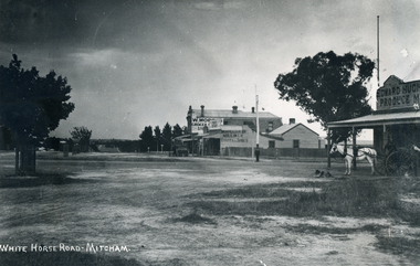
Photograph, Whitehorse Road Mitcham
... Very early view of shopping area of Whitehorse Road Mitcham; showing (corner Whitehorse and Mitcham Roads)- Edward Hughes Produce Merchant Draper Shop, Milliner, Boots & Shoes, W More's Grocer Horse and buggy in front of Produce store...Very early view of shopping area of Whitehorse Road Mitcham; showing (corner Whitehorse and Mitcham Roads)- Edward Hughes Produce Merchant Draper Shop, Milliner, Boots & Shoes, W More's Grocer Horse and buggy in front of Produce store Whitehorse Road Mitcham Photograph Photograph ...Black & white picture. Very early view of shopping area of Whitehorse Road Mitcham; showing (corner Whitehorse and Mitcham Roads)- Edward Hughes Produce Merchant Draper Shop, Milliner, Boots & Shoes, W More's Grocer Horse and buggy in front of Produce storewhitehorse road mitcham, hughes, edward, more, w. -
 Phillip Island and District Historical Society Inc.
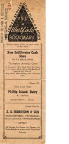
Ephemera, Bookmark Cowes shops, About 1960
... Most are in the main shopping area around Thompson Ave. Cowes is consistently spelt incorrectly as Cows....Most are in the main shopping area around Thompson Ave. Cowes is consistently spelt incorrectly as Cows. ...Lists stores and businesses in Cowes in about 1960. Most are in the main shopping area around Thompson Ave. Cowes is consistently spelt incorrectly as Cows.HistoricalBeige coloured cardboard strip with black lettering on both sides, advertising stores and businesses in Cowes.Use a Westfield Bookmark. The leaves request don't turn us downde la haye family, w. jenson dairy, a.g. morrison greengrocer, a. odlund electricals, j. harold smith real estate, j. white hairdresser, p.b. west draper -
 Lakes Entrance Historical Society
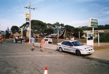
Photograph - Club Hotel Fire Lakes Entrance Victoria 2000, LERHS
... Colour photograph showing parked police vehicle in front of the drive-in bottle shop area, still standing, of the Club Hotel, following the early morning fire that destroyed the hotel. ...Date made December 2000 Hotels Fire Brigade Police Colour photograph showing parked police vehicle in front of the drive-in bottle shop area, still standing, of the Club Hotel, following the early morning fire that destroyed the hotel. ...Date made December 2000Colour photograph showing parked police vehicle in front of the drive-in bottle shop area, still standing, of the Club Hotel, following the early morning fire that destroyed the hotel. Signage undamaged behind the red and white tape erected by the police to keep sightseers out. Fire brigade vehicle and members of the fire brigade still wetting down smouldering debris. hotels, fire brigade, police -
 Stawell Historical Society Inc
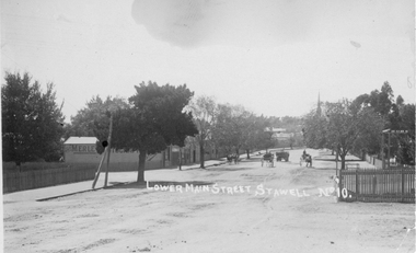
Photograph, Lower Main Street Stawell looking East c1905. Merle Photographic Studio at Left
... The photo was taken from the railway gates towards the main shopping area. The Presbyterian spire can be seen in the back ground. c1905....The photo was taken from the railway gates towards the main shopping area. The Presbyterian spire can be seen in the back ground. c1905. stawell shops business streetscape building transport Lower Main Street Stawell No 10. is inscribed on the front and The "Merle Studio" Main Street, Stawell on the back. ...Lower Main Street looking East from Railway gates. Shows four horse drawn vehicles. The photo was taken from the railway gates towards the main shopping area. The Presbyterian spire can be seen in the back ground. c1905.Sepia Postcard of a street scene the roadway is central in picture featuring 4 horse drawn vehicles. Street is tree lined with picket fence on right side of photograph. 0007a taken opposite the Diamond house looking down Seaby St. toward the railway crossing.Lower Main Street Stawell No 10. is inscribed on the front and The "Merle Studio" Main Street, Stawell on the back.stawell shops business streetscape building transport -
 Bacchus Marsh & District Historical Society
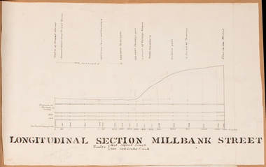
Drawing, Longitudinal Section Millbank Street Bacchus Marsh circa 1905
... Millbank Street is a short street located close to the central business and shopping area of Bacchus Marsh. In the early 1900s works to improve the drainage of the street were discussed and planned by Bacchus Marsh Shire Council. ...Millbank Street is a short street located close to the central business and shopping area of Bacchus Marsh. In the early 1900s works to improve the drainage of the street were discussed and planned by Bacchus Marsh Shire Council. ...Millbank Street is a short street located close to the central business and shopping area of Bacchus Marsh. In the early 1900s works to improve the drainage of the street were discussed and planned by Bacchus Marsh Shire Council. This plan is most probably the plan discussed at a Shire Council meeting in April 1905. Single page plan showing a longitudinal section view of MIllbank Street running from Clarinda Street to Grant Street in Bacchus Marsh. The names of Millbank Street property owners, Cain, Shelley, Oliver and Ramsay are marked on this plan. Scale: Vertical 10 feet to 1 inch. Horizontal: 100 links to 1 inch Part of a set of maps which are pasted into a bound volume containing 76 maps or plans in total. High resolution digital image stored on BMDHS computer network. bacchus marsh victoria maps, millbank street bacchus marsh -
 Greensborough Historical Society
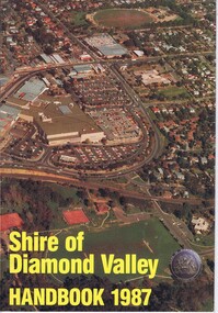
Booklet, Shire of Diamond Valley Handbook 1987, 1987_
... Cover illustration of aerial view of Greensborough shopping area and environs....Cover illustration of aerial view of Greensborough shopping area and environs. Annual guide to services in Shire of Diamond Valley shire of diamond valley greensborough handbooks 32 pages, col illus., maps. 2 copies. ...Guide to services provided by Shire of Diamond Valley. The Shire of Diamond Valley was a Local Government Area located about 20 kilometres northeast of Melbourne. The shire covered an area of 74.38 square kilometres and existed from 1964 until 1994. Cover illustration of aerial view of Greensborough shopping area and environs.Annual guide to services in Shire of Diamond Valley32 pages, col illus., maps. 2 copies.shire of diamond valley, greensborough, handbooks -
 Ballarat Tramway Museum
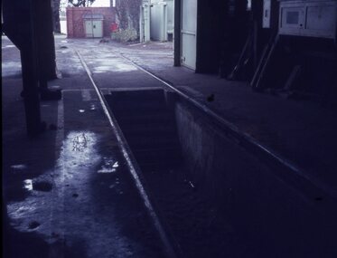
Slide - 27 mm sq slide/s - set of 4, Lilian Butler, scenes at the SEC Wendouree Parade depot, Sep. 1971
... Set of four Colour 27 x 27 mm slide in Agfachrome blue and white plastic mounts showing various views and scenes at the SEC Wendouree Parade depot .1 - view along No. 1 road looking outwards, shows the pit and the access steps. .2 - No. 38 in the paint shop area. .3 - ditto at the rear of the depot. .4 - View showing the notice board area - shows tramcars allocated against run numbers and for Sunday. ...Ballarat Tramways trams Depot SEC Depot Signs tram 38 Set of four Colour 27 x 27 mm slide in Agfachrome blue and white plastic mounts showing various views and scenes at the SEC Wendouree Parade depot .1 - view along No. 1 road looking outwards, shows the pit and the access steps. .2 - No. 38 in the paint shop area. .3 - ditto at the rear of the depot. .4 - View showing the notice board area - shows tramcars allocated against run numbers and for Sunday. ...Yields information about the appearance and facilities within the SEC tram depot.Set of four Colour 27 x 27 mm slide in Agfachrome blue and white plastic mounts showing various views and scenes at the SEC Wendouree Parade depot .1 - view along No. 1 road looking outwards, shows the pit and the access steps. .2 - No. 38 in the paint shop area. .3 - ditto at the rear of the depot. .4 - View showing the notice board area - shows tramcars allocated against run numbers and for Sunday. Photo from the collection of Lilian Butler. ballarat, tramways, trams, depot, sec depot, signs, tram 38 -
 St Kilda Historical Society
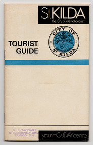
Document - Pamphlet, St Kilda the City of internationalism, tourist guide, c1970
... Includes information on shopping areas; fun things to do; dining, drinking and dancing; sightseeing; nearby beauty spots; and what to do in Melbourne....Includes information on shopping areas; fun things to do; dining, drinking and dancing; sightseeing; nearby beauty spots; and what to do in Melbourne. ...Tourist Guide for 'St. Kilda the City of internationalism', 'your HOLIDAY centre'. Undated but appears to have been produced in 1970 because it refers to Sergio's Cabaret, which opened in mid-1969, and the Victory Theatre, which closed in 1971. Includes information on shopping areas; fun things to do; dining, drinking and dancing; sightseeing; nearby beauty spots; and what to do in Melbourne.Multi-page pamphlet of white paper printed in black and blue and stapled.st kilda tourism -
 Sunbury Family History and Heritage Society Inc.
Photograph
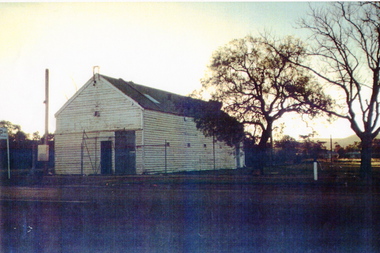
... In latter years two depots were built out of the immediate shopping area in Jackson Street, opposite the Ball Court and at the intersection of Elizabeth Drive and Gap Road. ...In latter years two depots were built out of the immediate shopping area in Jackson Street, opposite the Ball Court and at the intersection of Elizabeth Drive and Gap Road. ...Sunbury Bush Fire Brigade was established in Evans Street in a small wooden building near the Post Office in 1910 and adjacent to the former recreation reserve. It was later moved to the opposite side of the street, near the former Collins Bookshop. In latter years two depots were built out of the immediate shopping area in Jackson Street, opposite the Ball Court and at the intersection of Elizabeth Drive and Gap Road. A fire service has operated in Sunbury at various sites for over 110 years.A coloured photograph of a weatherboard garage with a corrugated iron roof. A cyclone wire fence and gate are across the front and two trees are growing at the side of the building.sunbury bush fire brigade, evans street, sunbury, sunbury cfa -
 Bacchus Marsh & District Historical Society
Map - Land Sales Plan, Grantbank Estate Bacchus Marsh, 1924
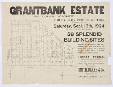
... The Grantbank Estate was a parcel of land close to the centre of the shopping area of Bacchus Marsh which was sub-divided and offered for sale in 58 lots on the 13th September, 1924. ...The Grantbank Estate was a parcel of land close to the centre of the shopping area of Bacchus Marsh which was sub-divided and offered for sale in 58 lots on the 13th September, 1924. ...The Grantbank Estate was a parcel of land close to the centre of the shopping area of Bacchus Marsh which was sub-divided and offered for sale in 58 lots on the 13th September, 1924. It comprised an area of 15 acres, being a portion of the Millbank Estate which had been in the hands of the Grant family for 75 years. The lots had frontages to Gisborne Road, Patterson, William and Sutherland Streets. This was a significant sub-division of land and represented a major expansion of residential housing in Bacchus Marsh in the early 20th century.This land sale map is a typical example of housing estate land sales advertising maps produced by real estate agents in this era. The map is significant for the detailed information it provides about when and where land was sold for new housing estates in Bacchus Marsh in the early twentieth century.Printed paper mapland sales bacchus marsh, land subdivsion bacchus marsh, housing estates land sales bacchus marsh, grant family bacchus marsh -
 Greensborough Historical Society
Article - Newspaper clipping, Fields give way to business boom, 1993_
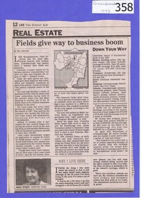
... Tells some of the story of the settlement of Greensborough and Lend Leases' gradual take over of Greensborough shopping area. In Canberra Times Wednesday 17 November 1993, page 27: Melbourne: Lend Lease Corp Ltd is to undertake a $600 million redevelopment of two suburban Melbourne shopping centres, at Dandenong and Greensborough; to be built in conjunction with Australia's largest retailer; Coles Myer Ltd. ...Tells some of the story of the settlement of Greensborough and Lend Leases' gradual take over of Greensborough shopping area. In Canberra Times Wednesday 17 November 1993, page 27: Melbourne: Lend Lease Corp Ltd is to undertake a $600 million redevelopment of two suburban Melbourne shopping centres, at Dandenong and Greensborough; to be built in conjunction with Australia's largest retailer; Coles Myer Ltd. ...Tells some of the story of the settlement of Greensborough and Lend Leases' gradual take over of Greensborough shopping area. In Canberra Times Wednesday 17 November 1993, page 27: Melbourne: Lend Lease Corp Ltd is to undertake a $600 million redevelopment of two suburban Melbourne shopping centres, at Dandenong and Greensborough; to be built in conjunction with Australia's largest retailer; Coles Myer Ltd. The project will create about 2000 jobs; 1000 during construction and 1000 in long-term retail.Has some history of Greensborough and records the average land prices in 1993. A black and white Sunday Age newspaper story. Includes map and photograph of resident.greensborough, lend lease, 1993, land prices
