Showing 212 items matching "shopping complex"
-
 Sunbury Family History and Heritage Society Inc.
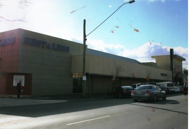
Photograph, Rosa McCall, Sunbury Shopping Square, 2011
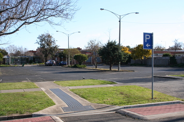
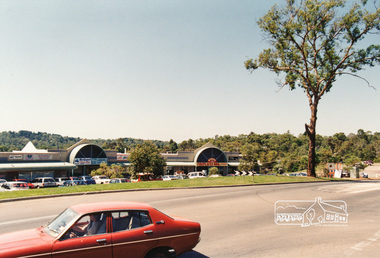
... ...Shopping Complex...The shopping complex opened own the site in late 1989....A coloured photograph of a shopping complex in a Main Street with cars angle parked along the kerb....Evans Street Shopping Complex Sunbury Shopping Square A coloured photograph of a shopping complex in a Main Street with cars angle parked along the kerb. ...The shopping complex is in Evans Street, Sunbury and it was built on the land that was a former sports ground and also housed the first CFA building in Sunbury and the scout hall. The shopping complex opened own the site in late 1989.This was the first large shopping complex to be built in Sunbury. Three more shopping areas were built in Sunbury between 1990 and 2005 on former railway land.A coloured photograph of a shopping complex in a Main Street with cars angle parked along the kerb.evans street, shopping complex, sunbury shopping square -
 Ringwood and District Historical Society
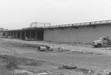
Photograph, Target Square shopping complex under construction, Seymour Street, Ringwood - 1984
... Target Square shopping complex under construction, Seymour Street, Ringwood - 1984....Target Square shopping complex under construction, Seymour Street, Ringwood - 1984. ...Written on back of photograph, "Target Square being built 1984". -
 Ringwood and District Historical Society
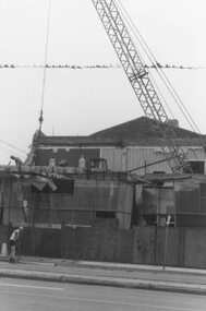
Photograph, Demolition to make way for Target Square shopping complex, Seymour Street, Ringwood - 1984
... Demolition to make way for Target Square shopping complex, Seymour Street, Ringwood - 1984....Demolition to make way for Target Square shopping complex, Seymour Street, Ringwood - 1984. ...Written on back of photograph, "Demolition to make way for Target and market 1984". -
 City of Greater Geelong
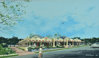
Painting - Watercolour, Wallace, Drysdale Village Shopping Complex
... Drysdale Village Shopping Complex...City of Greater Geelong 100 Brougham St Geelong geelong-and-the-bellarine-peninsula Drysdale Village Shopping Complex Painting Watercolour Wallace ... -
 Ringwood and District Historical Society
Photograph, Construction work at Target Square, NE corner of Maroondah Hwy and New Street, Ringwood - 1981, 1981
... Two views of Target Square shopping complex building under construction....Two views of Target Square shopping complex building under construction. Construction work at Target Square, NE corner of Maroondah Hwy and New Street, Ringwood - 1981. ...Two views of Target Square shopping complex building under construction.Written on back of photographs - V134a "29-6-81 View from Verstegen's no - New St across Brambles lot at the centre of Target building cnr of Charters-New St on right below Target." - V134b "30-6-81. Looking south from Brambles across Charter St. west end of Target. New St. just out of picture right". -
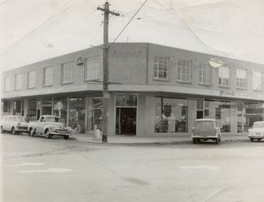 Sunshine and District Historical Society Incorporated
Photograph - Shops Dickson Street Corner Clarke Street, 1962
... Photograph of shopping complex built on Dickson Street Sunshine corner of Clarke Street by Mr M Mott...Dickson Street Clarke Street Sunshine Melbourne Leander Mott Shop Photograph of shopping complex built on Dickson Street Sunshine corner of Clarke Street by Mr M Mott Shops Dickson Street Corner Clarke Street Photograph Shops Dickson Street Corner Clarke Street ...Photograph of shopping complex built on Dickson Street Sunshine corner of Clarke Street by Mr M Mottdickson street, clarke street, sunshine, melbourne leander mott, shop -
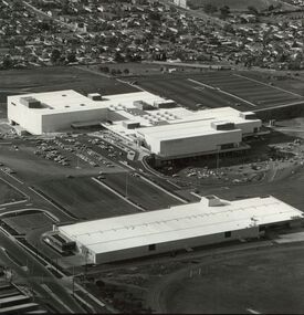 Sunshine and District Historical Society Incorporated
Photograph - Highpoint West shopping centre, 1975
... Photo of Highpoint West shopping complex which was built in a disused quarry Shows car parking areas and Myer and Waltons stores...Highpoint West Centre Building Maribyrnong Myers Waltons Photo of Highpoint West shopping complex which was built in a disused quarry Shows car parking areas and Myer and Waltons stores Highpoint West shopping centre Photograph Highpoint West shopping centre ...Photo of Highpoint West shopping complex which was built in a disused quarry Shows car parking areas and Myer and Waltons storeshighpoint west centre, building, maribyrnong, myers, waltons -
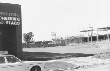
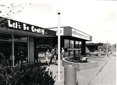 Hume City Civic Collection
Photograph
... A black and white photograph of a small shopping complex showing a craft shop and a coffee lounge. ...The photograph was taken in the centre of this developed area. shopping centres bakery walk link arcade let's be crafty suzanne's coffee lounge george evans collection A black and white photograph of a small shopping complex showing a craft shop and a coffee lounge. ...In the early 1980s, the CBD of Sunbury bounded by Evans, Brook, O'Shanassy and Station Streets underwent major redevelopment. The photograph was taken in the centre of this developed area.A black and white photograph of a small shopping complex showing a craft shop and a coffee lounge. Five people are at the entrance of the small arcade.shopping centres, bakery walk, link arcade, let's be crafty, suzanne's coffee lounge, george evans collection -
 Sunbury Family History and Heritage Society Inc.
Photograph
... A coloured photograph of an off-street carpark behind a shopping complex. Two cars are parked in the area and a nature strip with a parking sign in the foreground....Yakka factory Barkly Street Angee Clothing Sunbury A coloured photograph of an off-street carpark behind a shopping complex. Two cars are parked in the area and a nature strip with a parking sign in the foreground. ...The carpark is in Barkly Street, behind the O'Shanassy Shopping strip. In the 1940s-1950s, a former textile factory occupied the site. The factory was housed in an ex-army hut and many of Sunbury's women were employed there. From 1946 - 48, the business was known as Angee Clothing, which produced gloves, slippers and dressing gowns. In 1949, the site was taken over by Yakka, where work clothes were made. As the business expanded it moved to Broadmeadows in a large modern factory.While the factory was in Sunbury, it provided employment for a lot of the local women.A coloured photograph of an off-street carpark behind a shopping complex. Two cars are parked in the area and a nature strip with a parking sign in the foreground.yakka factory, barkly street, angee clothing, sunbury -
 Whitehorse Historical Society Inc.
Map, Proposed Mitcham Shopping Centre, 1979
... Proposed shopping complex of Mitcham - site plan and ground floor tenancy layout. ...Mitcham Shopping Centre City of Nunawading Coles Supermarket Mitcham Proposed shopping complex of Mitcham. Proposed shopping complex of Mitcham - site plan and ground floor tenancy layout. ...Proposed shopping complex of Mitcham.Proposed shopping complex of Mitcham - site plan and ground floor tenancy layout. Four stages of development for this shopping centre by Clarke Hopkins and Clarke Architects included.Proposed shopping complex of Mitcham.mitcham shopping centre, city of nunawading, coles supermarket, mitcham -
 Wodonga & District Historical Society Inc
Photograph - Codling Collection 01 - Wodonga Shire Hall
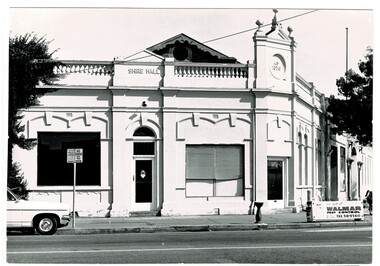
... Now the location of Woolworths shopping complex. Also incorporated the Melba Theatre...Now the location of Woolworths shopping complex. Also incorporated the Melba Theatre Codling Collection 01 - Wodonga Shire Hall Photograph Codling Collection 01 - Wodonga Shire Hall ...Miss Olive Codling was a Foundation Member and a Life Member of the Wodonga Historical Society. Many of her prize-winning photos are held in the Society Collection. She also held a range of roles and committee positions in a wide range of Wodonga community organisations. These included the Horticultural Society, the Wodonga Arts Council, the Wodonga Camera Club and the Wodonga Lapidary Club. Wodonga Shire was created in 1876 when the colonial government agreed to ratepayers' petitions to have their part of the local government district severed from the Yackandandah Shire to form a new municipality. After meeting for 14 years in rented premises, in the Prince of Wales Hall, Wodonga Council built its first Shire Hall on the corner of High and Elgin Streets in 1890. The date on the facade of the building represents the date of the formation of the Shire.This image is significant as it documents an important building and era in the development of local government in Wodonga.Wodonga Shire office at corner of High street and Melbourne Road Built 1876 demolished 1971 . Now the location of Woolworths shopping complex. Also incorporated the Melba Theatre On facade of building: " A.D. 1876"high st wodonga, wodonga local government, shire hall wodonga -
 Bendigo Historical Society Inc.
Photograph - AERIAL VIEW BENDIGO, 1995
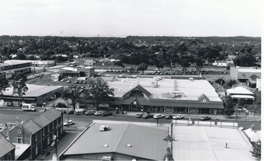
... Black and white photo: aerial view Mollison St., Jewel Shopping complex ( Noelene Wild 7/2000 ) from St. ...History House 11 Mackenzie Street Bendigo goldfields PLACE Aerial view of bendigo Peter Hyett Black and white photo: aerial view Mollison St., Jewel Shopping complex ( Noelene Wild 7/2000 ) from St. ...Black and white photo: aerial view Mollison St., Jewel Shopping complex ( Noelene Wild 7/2000 ) from St. Paul's tower ? Mollison St. left to right foreground. 'B22A' black lead on rear.Peter Hyettplace, aerial view of bendigo -
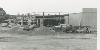
 Greensborough Historical Society
Photograph - Digital image, Greensborough Plaza Complex, 1979c
... View of Greensborough with Greensborough Plaza shopping complex in background. ...Greensborough Historical Society 34A Glenauburn Road Lower Plenty Lower Plenty melbourne View of Greensborough with Greensborough Plaza shopping complex in background. greensborough plaza Digital copy of colour photograph. ...View of Greensborough with Greensborough Plaza shopping complex in background. Digital copy of colour photograph.greensborough plaza -
Southern Sherbrooke Historical Society Inc.
Document - Information folder - proposed Demas Construction development at Belgrave South, 1976
... Information folder containing items [pertaining to the proposed building of a boutique shop complex on the south-eastern corner of Belgrave-Hallam Rd and Temple Rd, Belgrave South, in 1976. ...Southern Sherbrooke Historical Society Inc. 127 Colby Drive Belgrave Heights 3160 yarra-valley-and-the-dandenong-ranges Information folder containing items [pertaining to the proposed building of a boutique shop complex on the south-eastern corner of Belgrave-Hallam Rd and Temple Rd, Belgrave South, in 1976. ...Information folder containing items [pertaining to the proposed building of a boutique shop complex on the south-eastern corner of Belgrave-Hallam Rd and Temple Rd, Belgrave South, in 1976. Contents: -Town Planning Appeals Tribunal, Appeal No. X76/455, Application No. 2437, dated 24th August 1976. 11 sheets of foolscap. -
 Lakes Entrance Historical Society
Photograph, Lakes Post Newspaper, 1994
... Small black and white photograph of framework of construction of Safeway shopping centre complex. Tradesmens vehicles, pipes, Lakes Entrance Victoria...Lakes Entrance Historical Society 4 Marine Parade Lakes Entrance gippsland Photograph appeared in Lakes Post Newspaper 14 September 1994, page 24 Retail Trade Small black and white photograph of framework of construction of Safeway shopping centre complex. Tradesmens vehicles, pipes, Lakes Entrance Victoria Photograph Lakes Post Newspaper ...Photograph appeared in Lakes Post Newspaper 14 September 1994, page 24Small black and white photograph of framework of construction of Safeway shopping centre complex. Tradesmens vehicles, pipes, Lakes Entrance Victoriaretail trade -
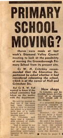 Greensborough Historical Society
Newspaper Clipping - Digital Image, Primary School Moving? Greensborough Primary School Gr2062, 21/08/1973
... Diamond Valley Councillors look at the possibility of moving Greensborough Primary School from its site on Grimshaw Street. [1973] The proposed new shopping complex for Greensborough would add to the dangers of traffic in the area. ...Greensborough Historical Society 34A Glenauburn Road Lower Plenty Lower Plenty melbourne Diamond Valley Councillors look at the possibility of moving Greensborough Primary School from its site on Grimshaw Street. [1973] The proposed new shopping complex for Greensborough would add to the dangers of traffic in the area. greensborough primary school Digital copy of newspaper article, black text and image. ...Diamond Valley Councillors look at the possibility of moving Greensborough Primary School from its site on Grimshaw Street. [1973] The proposed new shopping complex for Greensborough would add to the dangers of traffic in the area. Digital copy of newspaper article, black text and image.greensborough primary school -
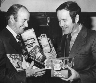 Box Hill Historical Society
Photograph - Ian Port, 1976
... These goods will be sent across to Matsudo to be displayed in the Box Hill shopping complex. ...These goods will be sent across to Matsudo to be displayed in the Box Hill shopping complex. Port> Ian Charlesworth> Alwyn Mayors Town clerks Manufacturing industry Matsudo> Japan B&w photo Photograph Ian Port ...Ian Port, Town clerk, with Mayor Cr. Alwyn Charlesworth displaying locally made goods at the "Made in Box Hill," in 1976. These goods will be sent across to Matsudo to be displayed in the Box Hill shopping complex. B&w photoport> ian, charlesworth> alwyn, mayors, town clerks, manufacturing industry, matsudo> japan -
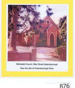 Greensborough Historical Society
Photograph, Unknown, Methodist Church Main Street Greensborough, 1940c
... This original site is now part of the Greensborough Plaza shopping complex. The Church moved to the new building in Grimshaw Street circa 1970s. ...This original site is now part of the Greensborough Plaza shopping complex. The Church moved to the new building in Grimshaw Street circa 1970s. ...The Greensborough Methodist Church stood in Main Street Greensborough and was central to the social life of the suburb in the early 20th century. This original site is now part of the Greensborough Plaza shopping complex. The Church moved to the new building in Grimshaw Street circa 1970s. This photograph shows the red brick church, now demolished.Copy of colour photograph of red brick church, mounted on yellow card and laminated.Caption: 'Methodist Church, Main Street Greensborough. Now the site of Greensborough Plaza'methodist church greensborough -
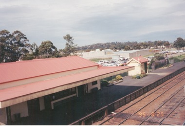 Sunbury Family History and Heritage Society Inc.
Photograph, Rosa McCall, 25 August 1995
... The rear view of one of the shopping complexes is also visible as well as a view of the wider town area....The rear view of one of the shopping complexes is also visible as well as a view of the wider town area. ...The photograph is a view of Platform 1 at Sunbury Station after the station underwent refurbishment and the platform was extended in 1993 as well as the carpark on the east side of the tracks. The rear view of one of the shopping complexes is also visible as well as a view of the wider town area.Sunbury Railway precinct has undergone a number of changes to cope with increased train services since the 19809s.A non-digital coloured photograph overlooking a railway station platform, carpark, commercial buildings and the area beyond the railway precinct.sunbury, sunbury railway station -
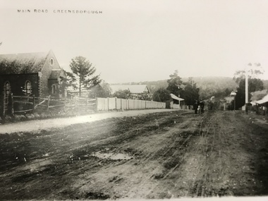 Greensborough Historical Society
Photograph, Main Road Greensborough c1900, 1900c
... Note Methodist Church on left, site of present entrance to the shopping complex. Also shows the Rechabite Hall further down on the left side. ...Note Methodist Church on left, site of present entrance to the shopping complex. Also shows the Rechabite Hall further down on the left side. ...Main Road (later re-named Main Street) Greensborough c1900. Note Methodist Church on left, site of present entrance to the shopping complex. Also shows the Rechabite Hall further down on the left side. Tracks of buggy wheels on unsealed road.A collection of 5 enlargements of sites in Greensborough township in the early 1900s.Black and white enlargement of photographic imagemain street greensborough, methodist church greensborough, rechabite hall -
 Ringwood and District Historical Society
Photograph, View of Ringwood in 1912 taken from Loughnan's Hill
... Field above is the football field with diagonal track coming out at Melbourne Street, later Eastland shopping complex. House on left is in Adelaide Street. ...Field above is the football field with diagonal track coming out at Melbourne Street, later Eastland shopping complex. House on left is in Adelaide Street. ...Black and white photograph looking across valley with small settlement. Mountains in background. (2 postcard copies and 2 enlargements). House in right foreground is in what is known now as Wildwood Grove. The dirt track above is Ringwood St. Field above is the football field with diagonal track coming out at Melbourne Street, later Eastland shopping complex. House on left is in Adelaide Street. Warrandyte Road is above it."Typed on back of one enlargement, "Copied from a postcard mailed in Ringwood, 1912, copied 1959. House in right foreground is in what is known now as Wildwood Grove. The dirt track above is Ringwood St. Field above is the present football field with diagonal track coming out at Melbourne Street. House on left is in Adelaide Street. Warrandyte Road is above it." House bottom RH side was still there in 1970 in Wildwood Grove (off Ringwood St). Ringwood Street lower centre to RH side. Field above Ringwood Street is the football field with diag. walk coming out at Melbourne Street. House on LH side in Adelaide Street. Warrandyte above it. Steam at LH from Bently's Steam Joinery at corner Main Street and Warrandyte Road. -
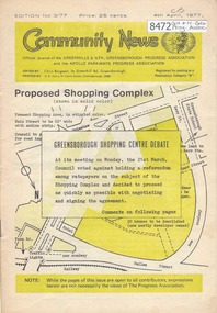 Greensborough Historical Society
Newsletter, Greenhills and North Greensborough Progress Association, Community News: official journal of the Greenhills and Nth. Greensborough Progress Association and the Apollo Parkways Progress Association. 4th April, 1977. Edition No. 3/77, 04/04/1977
... Proposed shopping complex: Greensborough shopping centre debate, Information or consultation - which? ...Greensborough Historical Society 34A Glenauburn Road Lower Plenty Lower Plenty melbourne Proposed shopping complex: Greensborough shopping centre debate, Information or consultation - which? ...Proposed shopping complex: Greensborough shopping centre debate, Information or consultation - which? The Greensborough shopping centre... two way communication, I remember when, Meet the natives, Diamond Valley Civic Centre Library, This and that, Local fauna controversy, Women's recreation, From the Council Chamber; Apollo Parkways street names, Kinder news. A digital copy of this Newsletter is available from Greensborough Historical Society. Newsletter, 20 p., illus.greenhills and north greensborough progress association, greenhills, apollo parkways progress association, apollo parkways -
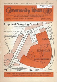 Greensborough Historical Society
Newsletter, Greenhills and North Greensborough Progress Association, Community News: official journal of the Greenhills and Nth. Greensborough Progress Association and the Apollo Parkways Progress Association.10th February, 1977. Edition No. 1/77, 10/02/1977
... Proposed shopping complex - Public meeting, Super shops, Letters to the Editor, From the Council Chamber, Freedom from despair, Grow, Co-operative education in Diamond Creek, This and that,. ...Greensborough Historical Society 34A Glenauburn Road Lower Plenty Lower Plenty melbourne Proposed shopping complex - Public meeting, Super shops, Letters to the Editor, From the Council Chamber, Freedom from despair, Grow, Co-operative education in Diamond Creek, This and that,. ...Proposed shopping complex - Public meeting, Super shops, Letters to the Editor, From the Council Chamber, Freedom from despair, Grow, Co-operative education in Diamond Creek, This and that,. Supplement to "Community News". No. 1/77. Geoff Kerry has a... Community News "family chat". A digital copy of this Newsletter is available from Greensborough Historical Society. Newsletter, 20 p., illus., map.greenhills and north greensborough progress association, greenhills, apollo parkways progress association, apollo parkways -
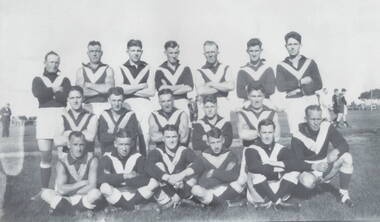 Sunbury Family History and Heritage Society Inc.
Photograph, Sunbury Football team, C 1930s - 1940s
... Th members of the Sunbury Football team were photographed on the former sports ground that was on railway land bounded by Evans and Macedon Streets, now a shopping complex. For many years that site was known as Sunbury's sports ground until 1949, when crown land facing Riddell Road was developed as a recreation and sport's ground and became known as Clarke Oval....Th members of the Sunbury Football team were photographed on the former sports ground that was on railway land bounded by Evans and Macedon Streets, now a shopping complex. For many years that site was known as Sunbury's sports ground until 1949, when crown land facing Riddell Road was developed as a recreation and sport's ground and became known as Clarke Oval. ...Th members of the Sunbury Football team were photographed on the former sports ground that was on railway land bounded by Evans and Macedon Streets, now a shopping complex. For many years that site was known as Sunbury's sports ground until 1949, when crown land facing Riddell Road was developed as a recreation and sport's ground and became known as Clarke Oval.Sport has played a prominent role in Sunbury and district's social life since the mid nineteenth century.A non-digital of a copied and enlarged black and white photograph of a team of football players standing and sitting in three rows in a sports ground. sunbury football club, "the swifts', sports clubs, football, australian rules football -
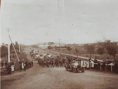 Sunbury Family History and Heritage Society Inc.
Photograph, A parade
... In the photograph the parade is approaching the intersection at Evans and Macedon Streets. Sunbury's Shopping complex now occupies the vacant land in the background, although for many years that land was the main sports ground. ...In the photograph the parade is approaching the intersection at Evans and Macedon Streets. Sunbury's Shopping complex now occupies the vacant land in the background, although for many years that land was the main sports ground. ...The parade took place in Sunbury in 1919 and was held to welcome home the local returned soldiers, who had enlisted in World War 1. In the photograph the parade is approaching the intersection at Evans and Macedon Streets. Sunbury's Shopping complex now occupies the vacant land in the background, although for many years that land was the main sports ground. The building in the distance was the Sunbury Fire Brigade.Many Sunbury men enlisted to fight in World War 1. Sadly some did not return home but others did.A copy of a non-digital sepia photograph of a parade being led along a road by a vintage car. There is open land with a few buildings in the distance. Spectators are watching the parade on either side of the roadway.evans street, macedon street, world war 1., parades, welcome home receptions -
 Sunshine and District Historical Society Incorporated
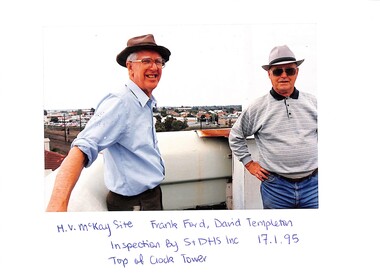
Photograph - McKay factory Bulk Store and the Historic Buildings Council on 17 January 1995, 17/01/1995 12:00:00 AM
... Series of 31 photographs depicting two buildings The Bulk store shows neglect after demolition of factory site and buildings Prior to incorporation into development of land for shopping complex proposed by Woolworths developers This building was one of two subjects for preservation of Historic Buildings Council hearing Developers for Woolworths made submissions for demolition Historic Buildings Council finding was in favour of preservation Reason for inspection was to provide information and input for Sunshine and District Historical Society preservation submission...McKay Massey Harris Massey Ferguson Series of 31 photographs depicting two buildings The Bulk store shows neglect after demolition of factory site and buildings Prior to incorporation into development of land for shopping complex proposed by Woolworths developers This building was one of two subjects for preservation of Historic Buildings Council hearing Developers for Woolworths made submissions for demolition Historic Buildings Council finding was in favour of preservation Reason for inspection was to provide information and input for Sunshine and District Historical Society preservation submission McKay factory Bulk Store and the Historic Buildings Council on 17 January 1995 Photograph McKay factory Bulk Store and the Historic Buildings Council on 17 January 1995 ...Series of 31 photographs depicting two buildings The Bulk store shows neglect after demolition of factory site and buildings Prior to incorporation into development of land for shopping complex proposed by Woolworths developers This building was one of two subjects for preservation of Historic Buildings Council hearing Developers for Woolworths made submissions for demolition Historic Buildings Council finding was in favour of preservation Reason for inspection was to provide information and input for Sunshine and District Historical Society preservation submissionh.v. mckay, h.v. mckay massey harris, massey ferguson -
 Sunshine and District Historical Society Incorporated
Archive - Sunshine Plaza / Market Place Development
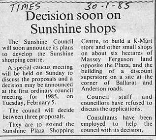
... The Council had acquired the land from Massey Ferguson and were considering developing the land into a large shopping complex. After complex discussions between developers, the site owners, councillors, consultants, legal advice and with the Victorian Government, the Council was forced to sell the site to private developers. ...In the end, Sunshine ended up with two distinct shopping complexes, the Sunshine Plaza on the east side of Hampshire Road, which is also on former Massey Ferguson land, and the Sunshine Market Place, on the west side of Hampshire Road, the large site of the former Massey Ferguson manufacturing site. ...The former Massey Ferguson site became a contentious issue for the City of Sunshine from the mid 1980's. The Council had acquired the land from Massey Ferguson and were considering developing the land into a large shopping complex. After complex discussions between developers, the site owners, councillors, consultants, legal advice and with the Victorian Government, the Council was forced to sell the site to private developers. The Victorian State Government stepped in and prevented the City of Sunshine in becoming the developers of the site due to the possible exposure to large amounts of financial debts. In the end, Sunshine ended up with two distinct shopping complexes, the Sunshine Plaza on the east side of Hampshire Road, which is also on former Massey Ferguson land, and the Sunshine Market Place, on the west side of Hampshire Road, the large site of the former Massey Ferguson manufacturing site. Both sites are now privately owned.5691.01 - Sunshine Plaza Development - Decision Soon On Sunshine Shops.jpg 5691.02 - Sunshine Plaza Development - Advice.jpg 5691.03 - Sunshine Plaza Development - Council May Become A Developer.jpg 5691.04 - Sunshine Plaza Development - Judge To Rule On Shop Site.jpg 5691.05 - Sunshine Plaza Development - Outspoken Plaza Boss To Stand For Council.jpg 5691.06 - Sunshine Plaza Development - Gwen Goedecke Letter Of Concerns 1989 Back.jpg 5691.06 - Sunshine Plaza Development - Gwen Goedecke Letter Of Concerns 1989 Front.jpg sunshine plaza, city of sunshine, george herscue, massey ferguson, sunshine market place, gwen goedecke -
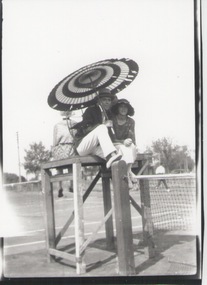 Sunbury Family History and Heritage Society Inc.
Photograph, C1920s
... The tennis courts in the photograph were located in Evans Street in Sunbury on the site of the present day Shopping Square complex. They were used by the townspeople in the 1920s. ...Sunbury Global Learning Centre Macedon Street Sunbury melbourne The tennis courts in the photograph were located in Evans Street in Sunbury on the site of the present day Shopping Square complex. They were used by the townspeople in the 1920s. ...The tennis courts in the photograph were located in Evans Street in Sunbury on the site of the present day Shopping Square complex. They were used by the townspeople in the 1920s. The various sporting clubs generated much community spirit in Sunbury.A non-digital black and white copy of an old photograph of a lady and man sitting under a sun umbrella on a tennis referee's seat at a tennis court. Some people are visible in the background playing tennis. tennis, tennis courts. -
 Eltham District Historical Society Inc
Photograph, Bolton Street, Eltham
... Five colour photographs of Bolton Street showing Eltham South Shops and The Ridge complex....Eltham District Historical Society Inc 728 Main Rd Eltham melbourne bolton street eltham montmorency lower plenty shops factories the ridge Five colour photographs of Bolton Street showing Eltham South Shops and The Ridge complex. Bolton Street, Eltham Photograph ...Five colour photographs of Bolton Street showing Eltham South Shops and The Ridge complex.bolton street, eltham, montmorency, lower plenty, shops, factories, the ridge -
 Eltham District Historical Society Inc
Photograph, Bolton Street, Eltham
... Five colour photographs of Bolton Street showing Eltham South Shops and The Ridge complex....Eltham District Historical Society Inc 728 Main Rd Eltham melbourne bolton street eltham montmorency lower plenty shops factories the ridge Five colour photographs of Bolton Street showing Eltham South Shops and The Ridge complex. Bolton Street, Eltham Photograph ...Five colour photographs of Bolton Street showing Eltham South Shops and The Ridge complex.bolton street, eltham, montmorency, lower plenty, shops, factories, the ridge